Space Assets for Pipeline Integrity Management (PIMS)
←
→
Page content transcription
If your browser does not render page correctly, please read the page content below

IAC-11-B5.1.7

                   Space Assets for Pipeline Integrity Management (PIMS)
                                           Dr. Michiel Kruijff
                         SERCO/ESA, Noordwijk, The Netherlands, michiel.kruijff@esa.int

                                                   Dr. Andre Bos
                                        Delft, The Netherlands, bos@stcorp.nl

                                                 Mr. Rob Bos
                           EuroPIMS B.V., Haren, The Netherlands, rob.bos@europims.nl

                                                 Mr. Neo Modise
                             Sasol Gas, Randburg, South Africa, neo.modise@sasol.com

                                             Dr. Arjan Mieremet
                        Science & Technology, Delft, The Netherlands, mieremet@stcorp.nl

                                            Prof. Amnon Ginati
                  European Space Agency (ESA), Noordwijk, The Netherlands, amnon.ginati@esa.int

    Pipeline integrity management systems (PIMS) are a key concept in the gas and pipeline industry that aims to
ensure that pipeline systems are safe and full-time operational. It addresses infrastructure design & construction,
inspection & maintenance, management and documentation. Space Assets for PIMS is a feasibility study of the
European Space Agency’s Integrated Application Promotion program. Its objective is to investigate and define
services that provide added value to PIMS-related activities by integration of multiple space assets, i.e. Earth
Observation (EO), Satellite Navigation and Satellite Communication.
    The application of PIMS has been particularly successful in steadily reducing the number of incidents in pipeline
operation, due to e.g. accidental third party intervention, sabotage, corrosion or landslides. Nevertheless, pipeline
monitoring as performed today remains costly and therefore incomprehensive. Significant improvement can still be
achieved by more ubiquitous use of Geographical Information Systems (GIS), such as PIMOA, and other
innovations.
    S&T together with EuroPIMS are about to conclude the PIMS Space Assets feasibility study. Involved users are
the gas pipeline operators SASOL (South Africa) and GasUnie (The Netherlands). These users have expressed, as a
primary need, their interest in a cost reduction of pipeline inspections (surveys) and a more frequent and
comprehensive monitoring of various threats to the pipeline integrity. In particular, third party interference has to be
better avoided, especially in South Africa. The study has next addressed the added value, feasibility, viability and
sustainability of novel services based on integration of multiple space assets into PIMS activities. For example
satellite images (SAR, hyperspectral, optical) can be used to detect large industrial vehicles or areas where landslides
occur or subsidence takes place. In remote areas the pipeline could be equipped with sensor networks that transmit
in-situ measurements via satellite communication to a central data processing facility, where the data is then checked
for signs of corrosion and other anomalies. Finally satellite navigation can improve the georeferencing of pipelines
and the measurements, overcoming the drawbacks in using traditional station coordinates or paper drawings of the
pipeline.
    The study has so far resulted in a PIMS service design that integrates the PIMS PIMOA software suit with a
multi-source and wide area network of sensors. The sensor suite comprises EO imagery instruments (optical & radar)
for observing the surrounding conditions of the pipeline, in-situ sensors measuring basic pipeline data, and a
communication network to transmit all data into a centralised database for further analysis and processing. The
development of a pre-operational service together with the involved users is foreseen as a next step.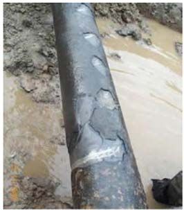
I. PIMSIS AND ESA’S INTEGRATED
APPLICATIONS PROGRAMME 2. Demonstration activities which aim at
demonstration of the ideas generated in the first
element.
I.1 ESA and IAP (ARTES 20)
IAP activities cover a wide range of themes,
The Pipeline Integrity Management Service In Space including Health, Transport, Energy, Development,
(PIMSIS) is a Feasibility Study of the Integrated Safety, Environment, Agriculture and Fisheries.
Applications Program (IAP) of the European Space
Agency (ESA). I.2 Space for Energy and Safety
ESA's Agenda 2011 contains a key objective: PIMSIS is an example of an IAP activity under the
"Development and Promotion of integrated applications theme “Space for Energy”. Typical Space for Energy
(space & non-space) and integration of security in the activities make use of the space assets Earth
European Space Policy. New concepts, new capabilities Observation, Satellite Navigation and Satellite
and a new culture have to be developed in order to Communication (Figure 1), for example in the context
respond to a multitude of needs from users who are not of:
yet familiar with space systems." Responding to this In-situ measurements & remote communication
objective are the Integrated Applications Programme Nowcasting/forecasting (based on e.g. weather)
(IAP), also known as ESA’s ARTES 20 element (user- of environmental conditions necessary for
driven applications), as well as the ARTES 3-4 power plant production generation (e.g. from
Telecommunications Applications element (product- alternative energy sources such as water, sun
driven applications). These elements are dedicated to wind, etc.)
development, implementation and pilot operations, Land subsidence / structural integrity
utilising not only Telecommunications satellites, but monitoring of power grids and other
also combining the use of different types of space infrastructure
assets, including Earth Observation and Navigation, as Third party interference monitoring
well as Human Spaceflight technologies.
The overall goal of the IAP program is the "the
development of operational services for a wide range of
users through the combination of different systems".
The goal is to incubate sustainable services to the
benefit of society that obtain their added value from the
innovative integration of existing terrestrial
technologies with space assets, such as
Figure 1. Space for Energy projects of IAP and the
Telecommunications, Earth Observation, Navigation, involved space assets.
and Human Spaceflight technologies. “Sustainable”
means here: triggered by, responsive to and sustained by SpaceGrid is focused on the monitoring of safe
real user demand, while taking into account financial corridors built around power lines. These corridors try
(e.g. commercial) and non-financial (e.g. environmental, to avoid interferences caused by e.g. building or
legal, adoptability) constraints. The provision of vegetation with the power lines. These monitoring is
commercial services (rather than of mere products) is currently done over 43000 Km of power lines in Italy,
seen as a key outcome - one that offers flexibility and using chage and subsidence detection
increases sustainability of demand, supply, and INTOGENER (INTegration of EO data and GNSS-
indirectly, up the value chain, also of space assets. In R for ENERgy Applications) support hydropower plant
this way, “our satellites help to do better the daily work operation in the Andean mountains of Chile by
of society”. performing large area water level prediction. Water
level is monitored using GNSS-R (reflected signal).
Such services are to be incubated through two steps Earth Observation SAR (snow height) and Optical/IR
or levels of ESA IAP activities: (temperature) data is integrated with water flow models
in order to make the required predictions. Satellite
1. Basic activities, which aim at generating, communications are used to transmit in-situ collected
assessing and studying ideas for projects. Feasibility data to the data processing centre, far away from the
Studies provide the preparatory framework to identify, mountains.
analyse and define new potentially sustainable CCS-SpaceMon (Carbon Capture & Storage)
activities. investigates the usability of multitemporal SAR for the
geomechanical monitoring of carbon subsurface storage and related service architecture will be defined in
sites. Calibration and confirmation is performed using consultation with the users;
differential GNSS. Satellite Communications are used
4. Proof of concept: not foreseen in the study due to
for data communication and remote monitoring.
budget constraints;
CSP-FoSyS is a Concentrated Solar Power Forecast
System. Nowcasting/Forecasting of environmental 5. Viability analysis: a comprehensive economic and
conditions is used as input for the estimation of solar non-economic viability analysis will be carried out,
parabolic-through power plants electricity output as well paying special attention to cost-efficient services
as for optimised maintenance planning. It is based on and the alignment of the activity with the
Earth Observation data (meteo) and in-situ legislation;
measurements, involving again Satellite
Communications for data provisioning. 6. Implementation Roadmap: the overall technical and
economic feasibility will be assessed; a
I.3 The PIMSIS Study comprehensive roadmap for the further
implementation and its associated services will be
The objective of the PIMS Feasibility Study is the drawn, as well as the preparation of a potential
assessment of the technical and economic feasibility of demonstration project;
the utilisation of space assets (Earth Observation,
SatNav, SatCom) in a pipeline integrity monitoring If concluded positively, it shall be followed by a
service, seamlessly integrating in real-time data from demonstration project in South Africa/Mozambique
terrestrial and space-based sources, increasing the (Sasol) and/or in the Netherlands (GasUnie) in which all
monitoring performance and reducing operational cost elements of the full service will be prototyped and run
and hazard. in pre-operational manner.
The users involved in the PIMSIS study are GasUnie
(NL) and Sasol Gas (SA)
III. PIPELINE INTEGRITY MONITORING
The study team consists of:
III.1 Background
Science & Technology B.V. (S&T) (NL, prime)
with experience in remote sensing data products Based on The World Fact Book, the total length of
and processing pipelines (gas, oil, and refined products combined) is
about 1.8 million kilometres. The European gas
EuroPims B.V. (NL, subcontractor) with expertise transmission network is about 225,000 km in length; it
in the operation of oil and gas pipelines and includes over 100 cross-border points and a similar
associated facilities (Shell, Gasunie, Sasol, Gaz de amount of underground storage facilities. The growth of
France NL, Total EP NL, Geoplin SL) the pipeline systems is fuelled by the increased
This consortium is already active in Pipeline dependency on imports and demand for renewable
Monitoring Management and has developed a PIMS sources (bio-methane).
software environment (PIMOA). PIMS International, The collection of pipeline safety data is growing in
the intended future service provider, has been founded significance as interest of responsible authorities for
in 2010 as a joint venture between S&T and EuroPims. safe gas transmission strengthens. Large operators
The study includes the following elements: typically spend several million Euros each year to
monitor their pipes. The total cost for monitoring
1. User requirements definition, analysing present and remote segments of pipelines is roughly estimated to
future legislation and relying on the inputs from the exceed 100 million Euros per year. This monitoring
participating pipeline operators the user effort pays off. Although the network is growing, the
requirements will be refined and captured; incident rate has decreased from about 0.9 per 1000
2. State-of-the-art analysis and identification, km/y in 1970 to the current value of 0.37 per 1000
identifying and analysing current terrestrial and km/y. It has been argued however that pipeline integrity
space technologies; identification of cost-efficient issues can have a significant impact on energy price,
technologies and technology gaps; even by tens of percentage points.
3. System and service definition: system and service Gas and oil pipeline integrity is a serious safety
specifications will regard functional, performance, concern. Over 50% of pipeline failures are the result of
interface and environmental aspects; reliable health third party intervention. This intervention may be by
and alarm indicators will be defined; the system accident (digging works) or from purposeful attempts to
interfere with or scavenge the gas or oil flow. Corrosion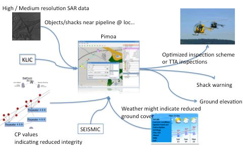
and ground movements are other common causes of              by the supportive normative documents. In summary,
incidents. Failures interrupt or affect the supply and in    there is a well-defined legal basis for improvement of
addition can lead to casualties, impact on the               the current monitoring practises.
environment, and damage the image of the stakeholders.
                                                                 With an inspection cost of approximately 1,000
Dramatic examples include one of the largest non-
                                                             Euro/km/year by helicopter, the targeted pipeline
nuclear explosions in history along the Trans-Siberian
                                                             network of about 90,000 km represents a market value
Pipeline in 1982, and the petroleum pipeline explosion
                                                             of about 90 million Euros per year which is considered
at Jesse in the Niger Delta in 1998 that killed 1200
                                                             sufficiently attractive to investigate this subject.
villagers, some of whom were scavenging gasoline.
                                                                 However, the economic viability will be impacted
    In most countries periodic inspections of natural gas
                                                             by the cost of the satellite data. A first survey indicates
pipelines are required by national legislation. Currently,
                                                             that the offered satellite data are not directly compatible
traditional pipeline inspection methods are used based
                                                             with the inspection requirements which ask only for a
on helicopter inspections with a cost of approximately
                                                             small area strip around the pipeline. Image resolution
1,000 Euro/km. Other pipeline costs include
                                                             and timeliness are also issues, that may be partly
maintenance (e.g. corrosion, valve failures), safety risks
                                                             countered by integration with an in-pipe / near-pipe
and downtime.
                                                             sensor grid combined with e.g. a Satcom SCADA
    The pipeline operators are supported by so-called        network – of course at additional cost. Therefore, a
Pipeline Integrity Maintenance Systems (PIMS) that           viability analysis will be performed that pays special
provide support in the administration, planning,             attention to the economic part.
analyses of inspection data and risk analysis activities
related to pipeline integrity. These PIMSs are usually
applications making use of the data of a Geographic                   IV. PIMSIS INTERMEDIATE RESULTS
Information System (GIS).
                                                             IV.1     The users and the threats they experience
    There are several products on the market varying
from just GIS-systems for presentation of the pipeline           Stakeholders in the addressed field are (high
on the map up to highly sophisticated tools used to          pressure) pipeline operators, regulators, pipeline
analyse inspection data, carry out risk assessments and      integrity    management      consults.   From     these
to support the pipeline operator in the development of       stakeholders, two oil/gas companies are involved in the
his Integrity Management Plan.                               activity, GasUnie (NL) and Sasol Gas (SA).
   It is expected that the integration of space assets in
                                                                 GasUnie produces natural gas at ~100.109 m3/year
such pipeline monitoring systems is able to detect
                                                             and is the main gas-pipeline operator in the Netherlands
problems easier and earlier, thereby reducing efforts,
                                                             with a network of 12.000 km pipeline. It is also a gas-
downtime, and cost.
                                                             pipeline operator in Germany (3.000 km pipeline).
    The proposed activity for a pipeline integrity           Furthermore it is a shareholder / operator of major
monitoring system concentrates on a subset of the            international pipes such as the Balgzand Bacton Line
pipeline system, i.e. the gas/oil pipelines that are         (BBL) between Netherlands and England, and
difficult or impossible to access, that are located in       Nordstream (Russia – Germany).
remote areas, and that do not have a reliable data
                                                                 In the Netherlands a reporting system is
infrastructure. A conservative estimate of the percentage
                                                             implemented (KLIC), that makes it mandatory to
of pipelines that fulfil above criteria is 5%
                                                             centrally register any intended excavation work. Albeit
(corresponding to 90,000km).
                                                             at a much lower rate, in this densely populated country,
                                                             incidents that cause pipeline damage continue to occur
III.2   Sustainability aspects for a PIMS service based
                                                             however (Figure 2). Ground cover over pipelines
on space assets
                                                             (including submerged ones) sometimes reduces due to
    In Europe, pipeline safety standards are derived         erosion or agricultural activity, leaving the pipelines
from ISO and CEN standards. They are more and more           much more vulnerable. Also light damage can lead to
often imposed by national legislation regulations which      gas leakage as a result of corrosion. The monitoring of
in turn follow the European Gas Directives of 1998,          the dense Dutch pipeline network therefore remains a
2003 and others. The European Standard EN 1594 for           necessity.
natural gas pipeline monitoring covers all relevant
technical safety aspects concerning the design,
construction, operation and maintenance of transmission
gas systems. PIMS and safety management are detailed
Figure 2. Pipeline coating damage due to excavation.
Sasol Gas operates and maintains own natural gas
and methane rich gas pipelines in South Africa and
Mozambique (~1200 km). It is contracted to operate and
maintain the Mozambique to South Africa gas
transmission pipeline including 1 compressor station
located in Komatipoort (~865 km), as well as to
maintain 6 other petrochemical pipelines (~600 km).
Finally, the National Energy regulator of South Africa
(NERSA) has Licensed Sasol Gas to operate the pipe
gas transmission, distribution and trading business.
Sasol Gas assets may be underground (pipelines,
valves) and aboveground (customer metering stations,
pressure reduction stations, scraper stations, solar
energy systems etc.).
Major threats to Sasol Gas assets include but are not
limited to the following:
external interference - unintentional damage to Figure 3. Pipeline networks of GasUnie in The
underground assets e.g. 3rd party contractors Netherlands and Germany (top) and Sasol Gas in South
erecting underground utilities Africa and Mozambique (bottom).
sabotage/theft on critical assets – solar energy units,
electrical cabling.
sabotage/theft on cellular assets – cellular SIM IV.1 Current PIMS operations and the user needs
cards (Subscriber Identity Module) used in remote Until recently, there were no legal requirements
communication have been stolen on numerous regarding the integrity and risk management of
occasions. pipelines - inspections were not prescribed. Both in
ecological – soil erosion, landslides and Europe and the US however operators are now
earthquakes e.g. in western Gauteng a historic requested to have a comprehensive integrated Pipeline
number of earth tremors has been reported via Integrity Management System (PIMS) in place,
USGS and SACGS. encompassing aspects of engineering, operation,
encroachment – formal and informal developments inspection, maintenance, communication etc. The
e.g. informal housing erected near pipelines. monitoring tasks include inspection to check for any
gas leaks – from underground and aboveground leak or damage of the pipeline, and that there is no
danger to the pipeline integrity from nearby
construction or ground movement activities, the so-
called third-party interference. Many operators are
currently looking into new technologies to effectively
meet the monitoring requirements and to deal safely
with the expected increase in gas consumption. This is a
challenge: on the one hand the market demands for gas
provision increase and require even more guarantees for
the supply of gas at a competitive cost, on the otherhand the resources for maintaining and operating the
transmission facilities need to be limited more and more
for cost reasons.
One of the passive protection mechanisms used by
the pipeline operators is placing the pipelines subsurface
with sufficient ground cover to protect the pipeline form
ground excavating activities (minimum about 80-100
cm). Having the pipes below ground however, makes
monitoring threats and damage much less trivial.
The use of helicopters or fixed-wing aircrafts is
currently often regarded as the most effective way of Figure 4. Screenshot of PIMOA software for PIMS.
detecting third-party interference. Inspection frequency
is typically 2 weeks, even if such frequency may not be Following in-depth discussions with the involved
sufficient. Besides the high operations cost, the use of users (Sasol Gas and Gasunie), taking into account
helicopters introduces additional hazards as they need to current operational scenarios, tools and methodologies
operate at an altitude which is lower than normal in use, operator needs and requirements have thus been
operations. formulated. In-line intrusive activities need to be
A second pillar for reducing risk of pipeline damage discovered earlier to reduce system downtime. A Right-
is corrosion protection of the pipeline system. This is Of-Way (ROW) zone of about 10-100 m around the
realized by impressed current, making the pipeline the pipeline is to be monitored for third party intervention.
cathode of an electrochemical cell. It is of great Landslides or other threats to the integrity should be
importance that it is verified that the Cathodic monitored and appropriate warning signals released.
Protection (CP) operates as intended. The CP— Helicopter operations should be reduced to minimize
installation, and other installations close to the pipelines cost and hazard. Measurements and observations should
(valves, flow meters, pressure meters, etc) need a secure be more precise and geo-tagged, as it still happens that
and dependable data link to send the data to the control the wrong pipeline segment is excavated after failure
centre, which processes these data to assess the health of reports. The monitoring must be adequate, secure,
the installations. In remote areas it is difficult and regular, cost-effective, and importantly, it should not
expensive to maintain this data link but even developed generate false alarms.
and more densely populated countries (like The With the recent availability of a range of
Netherlands) still rely on manual inspection (incl. by in- technologies, data sources and software systems, and
situ electric potential measurements) and data collection the ambition of many operators to upgrade their
of these installations which are considered expensive monitoring systems, a strong need exists for seamlessly
and do not deliver real-time data. The exact location of real-time integrated services, managed through a PIMS.
corrosion in a buried pipe is difficult to establish at great
precision, given that the measurements are indirect and Three major service functions have been categorized
measurement points are limited to about a few km as particularly interesting for the users:
intervals typically. More direct and continuous in-line The detection of third-party interference.
measurements from within the pipe (“pig-run”) are
exceedingly expensive and therefore are performed only The monitoring of the ground cover and
once every number of years. changes in it (e.g. due to erosion, land
slides)
Finally, IT systems form a vital part of the overall
management of the network to provide auditable results. A reliable data link of pipeline equipment
Pipeline operators require vast amounts of data in order to a central processing facility.
to manage the everyday activities related to pipeline
integrity: a PIMS provides the best way to store data IV.2 Previous studies and technological heritage
and solve the problem of data transparency. With this Preparatory studies on the use of space assets have
information available the operator can analyse the recently been performed which indicate that there is a
relationship between the different facts and figures and need and that the available technology is about to reach
make appropriate decisions related to pipeline the required performance.
inspections, repair plans and preventive measures. An
example of such a system is PIMOA, developed by The FP5 project PRESENSE (Pipeline REmote
S&T in collaboration with EuroPims (Figure 4). SENsing for Safety and the Environment) 1 (completed
in 2004) assessed the potential of remote sensingtechniques for PIMS including technology to 3. obtain system-health relation information about the
automatically find potential targets which might equipment related to the pipeline.
compromise pipeline security. It produced algorithms, a
prototype information system and a successful concept Nevertheless, the combination of data –coming from
demonstration. PRESENSE identified that for a different information sources– provides a very
commercially viable system satellite capabilities needed promising concept. Figure 5 depicts such a decision-
to be improved and extended, and data must be support system where the information of various
available at lower cost. information sources are combined and processed to
support the integrity-related activities.
The ESA activity PIPEMON 2 (completed in 2006)
included pre-commercial trials to introduce Earth
Various space assets are being considered. EO data
Observation services to the pipeline industry. Results
(optical and SAR at 0.5-1 m resolution from a variety of
from the PIPEMON test sites identified that there is
commercial providers) will be used to detect third-party
strong interest by pipeline operators regarding InSAR
interference by performing change-detection between a
applications, particularly supported by distributed
current picture and a set of historical pictures of the
corner reflectors.
same area. A major advantage over current practise is
On the industrial side, the pipeline operator Sasol that an objective and comprehensive (full coverage)
has performed an internal study on the use of satellite semi-automated analysis can be made in this way.
communications and believes that the inclusion of Satellite communication will be used to establish a
Satcom systems can bring operational advantages. reliable link between the various in-situ sensors and a
GAZPROM started development of a small dedicated central (Supervisory Control And Data Acquisition)
satellite, PIMSpace. SCADA system.
So far however, remote pipelines have traditionally
There are limiting factors to what space assets can
been maintained by a technician going to a site to take
realistically provide in terms of monitoring:
readings and make adjustments. On his return, this data
- limited revisit time of satellites (in order of tens of
is integrated off-line in the control centre. Bi-weekly
days) – this can to some extent be resolved to the
inspections are also made from low-flying helicopters.
level of weeks (close to current monitoring
To improve coverage and lower the cost, wireless
practise) by invoking multiple suppliers.
communication devices are now being deployed, and
- still high cost for high resolution imagery (0.5-1
the supervisory control and data acquisition systems
m), especially when taking into account that the
(SCADA) are being extended with configuration item
typical minimal scene size (square of 50 km^2)
control/ enterprise resource planning tools (ERP) and
exceeds by orders of magnitude the required
GIS applications for pipelines.
narrow path around a pipeline. As a result, imaging
Novel techniques were developed under the a pipeline network from space has comparable cost
European GERG8 committee and include optical to that from a helicopter (yet not lower).
waveguides or fibre-optic systems installed alongside - Resolution from a helicopter remains significantly
pipelines to detect vibrations and temperature better to distinguish submeter details that may be
abnormalities. Microphones can be used to monitor the important for a trained eye to distinguish potential
gas flow at distances up to 15 km. Advanced UV/IR threats from what would essentially be false
spectroscopic laser systems (differential absorption alarms.
LIDAR) and infrared sensors have been developed that
can be used to detect gas leaks (methane) remotely. For this reason it is not yet feasible to replace current
They are capable of detecting gas clouds from methodology of helicopter inspection completely.
helicopters which are equipped with D-GNSS and fly at Rather, a staggered approach is being considered:
an altitude of 100 m and with a speed of up to 90 km/hr. 1. low-cost low-resolution data is used to identify
potential threat areas
IV.1 The proposed solution 2. high-resolution data is requested to analyze those
The proposed solution is to provide the user with a areas in more detail
service delivering information that will greatly enhance 3. the high-resolution data is analyzed, and combined
the decision process of the integrity management with or checked against recent and/or historical
officers. The major idea is to combine and fuse data ground measurements and reference imagery.
coming from different origin in order to at least 4. change detection identifies spots to be investigated
1. detect third-party interference as soon as possible, 5. targeted helicopter inspection and, subsequently,
2. monitor the ground cover, and possible in-situ investigations are requested.In order to monitor the changes in ground-cover flight speeds (shorter flights) and may involve semi-
InSAR techniques will be used 3 (low-res with Envisat, automated imaging from the helicopter.
Sentinel-1 or in some cases hi-res with commercial
systems), exploiting the phase-difference present
between current and a set of historical SAR images. For
the threat that can be identified in this way
(erosion/landslides), currently only very limited
terrestrial monitoring is in place, therefore the case for
this service is more straightforward.
In this system concept, the data of the various
information sources are combined within the PIMOA
system, such that the link between the ingested data is
primarily linked by their geographic parameters. That is,
in PIMOA it will be possible to link features of the
ingested data using the geographic position. In such a Figure 5 Decision support system to create better
way, it will be possible to determine whether a feature situational awareness related to pipeline integrity
in an earth observation image is close to a pipeline.
With possible third-party interferences detected, one can
optimize the inspection cost and coverage by optimizing IV.1 The added value of space assets
the helicopter flights. Also, if some idiosyncratic value
in the inspection data (pigrun, CP-values) is noticed The involvement of space assets is expected to
(indicating, e.g., a possible damage of the protective provide added value to a future Pipeline Integrity
layer of the pipelines) –to explain the damage- the Monitoring System:
historical record of SAR images is analyzed to identify Earth Observation: Remote sensing technologies
whether in the past a possibly related interference was combined with proper feature extraction algorithms
detected by the system. can provide relevant information for many of the
critical pipeline monitoring needs. Third party
Figure 5 shows a number of possible information interference can be detected indirectly through
sources that will feed the decision-support system. change in position of surface features related to
Figure 5 is, however, not intended to be exhaustive; it excavation practises over successively obtained
shall be possible to ingest other information sources as images. Such images may in principle originate
well. For example, we have identified SAR as the main from a wide variety of sensors, such as SAR,
source for space-born images, but other images (such as optical, thermal and LIDAR, but from satellites,
optical) shall be possible as well. Also, the information SAR and optical (VNIR) are the more suitable
sources that are present in Figure 5 need not be present candidates. SAR is more expensive, less widely
in a real-life implementation of the decision-support available and somewhat lower in resolution, but
system. Besides data coming from EO-sensors or insensitive to cloud cover or time of day
transported using satellite communication, the system (day/night). Subsidence of the ground and
will also be able to ingest data from earth-bound sensor landslides can typically be observed from space
systems, such as a seismic measurement network. using SAR interferometry. Gas leakage has been
observed in proof of concept demonstrations
All these data sources combined together with the directly using aerial spectrometers and indirectly
(geographical) information available of the pipeline from space (IKONOS) through their effects on
infrastructure will deliver a comprehensive view of the vegetation, although both type of measurements
possible threats for the pipeline integrity. For example, have been found to be ambiguous and are not likely
inspection of the SAR images may indicate a change to be sufficiently reliable to be cost-effective.
close to the pipeline indicating major ground excavating Overall however, integration of space based remote
activities. During ingestion of the data, the system will sensing with terrestrial techniques as opposed to
check for a wide range of possible threats and will purely aerial tracing of the pipelines may offer
inform the pipeline integrity officer. The officer will be lower cost and provide greater continuity and better
able to further analyze these warnings e.g. by inspection spatial context;
of historical data. The outcome of these analyses should
then result in optimized (flight) inspection schedules to Satellite Navigation: High integrity and more
warrant integrity of the pipeline infrastructure. This accurate positioning data by augmented GPS (such
optimization is likely to include more targeted flights as by EGNOS) allows to more unambiguously
(skipping large parts of the infrastructure) and higher identify fault and digging locations (for pipelinevisual inspection or repair) and stay-out zones (for steadily increasing performance of space infrastructure,
third parties). GPS-sourced time tags and guidance ESA IAP has started the PIMSIS study.
by augmented GPS (such as by EGNOS) could help In PIMSIS, operational scenarios and needs for
to provide more effective in-situ manual enhancements in pipeline integrity monitoring systems
measurements on buried (invisible) pipelines. For have been obtained from two major, and distinct,
monitoring of the Cathodic Protection, precisely pipeline operators (Sasol Gas and Gasunie), who have
timed coordinated measurements (at 0.01 s absolute taken the role of (potential) users. Three major service
accuracy) need to be made along the pipe. Also functions have been categorized as particularly
investigators typically need to trace the interesting for these users:
underground (invisible) pipe accurately above
ground for continuous measurements. The detection of third-party interference.
Some technological opportunities for differential The monitoring of the ground cover and changes in
navigation (D-GNSS) technologies have been it (e.g. due to erosion, land slides)
identified, however it should be noted that no needs A reliable data link of pipeline equipment to a
for these have been expressed so far by the users: central processing facility.
- Aerial or helicopter based observations, which are
more suited for detailed investigations and leakage A commercial service provision scheme is
detection due to their higher resolution and much currently being developed that integrates terrestrial
smaller target distance, may be accurately geo- technologies (helicopter inspections, Cathodic
tagged using D-GNSS systems and precise data on Protection in-situ monitoring and PIMS software) with
sensor pointing to allow for automated processing space assets (optical and SAR earth observation data at
and easy integration into a GIS environment. 30 m down to 0.5 m resolution, SatCom, GNSS). The
expectation is that this service can optimize, rather than
- D-GNSS applications could be a suitable replace, the current PIMS methodologies. A full
technique for monitoring of pipeline motion in replacement of helicopter inspection flights has been
critical areas. found to be not (yet) possible. However, certain threats,
Satellite Communications: Supporting a secure, such as ground cover erosion are very hard and costly to
seamless and real-time integration of data, Satcom regularly monitor with current terrestrial means, while
can provide the communication link for existing space assets provide good opportunities. Also, at the
pipeline infrastructure and the collection of data moment, corrosion monitoring is currently hardly
from a local WiFi enabled sensor networks. This integrated with aerial inspections. The PIMSIS service
can be achieved by the implementation of a package would combine these strengths to provide
SCADA network with e.g. VSAT terminals higher reliability at the same or lower cost.
connected to the control centre. The detailed design and commercial viability are the
next steps to be performed.
If concluded positively, it shall be followed in the 2012
V. CONCLUSON timeframe by a demonstration project in South
Africa/Mozambique (Sasol) and/or in the Netherlands
Earlier research (PIPEMON, PRESENSE), has (GasUnie) in which all elements of the full service will
suggested that space assets are relevant tools for be prototyped and tested.
pipeline integrity monitoring (PIMS). Nevertheless, no
space assets are currently being exploited. Considering
REFERENCES
1
http://www.presense.net/
2
http://www.pipemon.com/
3
Mark Richards, A Beginner’s guide to interferometric SAR concepts and signal processing, IEEE A&E Systems
magazine, Volume 22, No. 9, September 2007.You can also read