The Laki Fissure eruption, 1783-1784 - Auteurs : Encyclopédie de l ...
←
→
Page content transcription
If your browser does not render page correctly, please read the page content below
The Laki Fissure eruption, 1783-1784
     Auteurs :

                                                                                                            14-01-2020

        In 1783, a mysterious dry fog enveloped the continent of Europe, blood-red sunsets were reported throughout the
      summer, and many reported a sulfuric smell, breathing difficulties and sore eyes. The Europeans were unaware
      that this was the result of a devastating event unfolding in Iceland. Many other phenomena were recorded
      throughout the year, including earthquakes and unusually frequent thunderstorms, leading to 1783 being dubbed an
      annus mirabilis, a year of awe. What could have caused these phenomena? Could these phenomena possibly all be
      connected?

Encyclopédie de l'environnement                           1/12                                         Généré le 16/12/2020
1. Iceland—The land of ice and fire

        Figure 1. Iceland’s location on two tectonic plates. The location of the Mid-Atlantic Ridge is shown here as a bold red line. The major
       volcanic zones are also indicated. [Source: Psiĥedelisto (add fault lines), Chris.urs-o (iceland outline) [CC BY-SA
       (https://creativecommons.org/licenses/by-sa/3.0)]

     On June 8, 1783, it began. In the highlands in southeastern Iceland, a volcano erupted. A 27-kilometer-long fissure tore
     through the landscape, beginning an eruption, which would last until February 7, 1784.

     Iceland is often referred to as a land of “ice and fire.” It’s home to many volcanoes and, due to its location in the North Atlantic
     and its proximity to the Arctic Circle several glaciers. Geologically speaking, Iceland is very young. It formed over the past 24
     million years, due mainly to two geological phenomena: Firstly, the fact that it is located at a diverging plate boundary, also
     known as a constructive plate boundary, as new crust is created here by the Mid-Atlantic Ridge. Iceland, perched upon both the
     Eurasian plate and the North American plate (Figure 1), grows by about two centimeters a year, one centimeter to the east and
     one to the west. Secondly, that it is located on top of a mantle plume, which is also known as a hot spot: A mass of relatively hot
     and therefore less dense mantle materials rise up from the Earth’s mantle towards the surface where it produces volcanism.

        Figure 2. Iceland and the location of the Laki Fissure, indicated by a red line to the SW of Vatnajökull. [Source:Max Naylor [Public
        domain]]

Encyclopédie de l'environnement                                       2/12                                                     Généré le 16/12/2020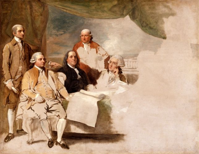
Iceland is divided into various volcanic zones, which make up a third of Iceland’s landmass (Figure 1). It is further divided into
     thirty volcanic systems, with a wide range of different volcano types. The Laki fissure eruption is located in a system called
     Grímsvötn. Grímsvötn is Iceland’s most productive volcanic system, fed by a central volcano of the same name that is located
     underneath the Vatnajökull ice shield. This system on average produces one volcanic eruption every 2-7 years. [1]

                             Figure 3. The delta of the Skaftá river in southern Iceland. [Source: Bjoertvedt [CC BY-SA
                            (https://creativecommons.org/licenses/by-sa/3.0)]]

     This volcanic eruption produced 14.7 cubic kilometers of lava. [2] The event was composed of ten eruptive episodes, each one
     beginning with strong earthquakes, followed by explosive activity, resulting in a new fissure segment. The entire fissure consists
     of around 140 craters, vents, and cones in a SW-NE direction, all the way to the Vatnajökull ice sheet, Iceland’s largest glacier
     (Figure 2). The total amount of lava produced covers an area of 599 square kilometers. [3]

         Figure 4. The NE part of the Laki Fissure, as seen from Mount Laki. In the distance, Vatnajökull is visible, Iceland’s largest glacier.
        [Source: Photo © Katrin Kleemann]

     The fissure is located at around 600 meters above sea level, whereas the coastal areas are much lower. Kirkjubæjarklaustur, a
     settlement on the southeastern coast, is located at 35 to 40 meters above sea level. So naturally, the large volumes of lava

Encyclopédie de l'environnement                                        3/12                                                     Généré le 16/12/2020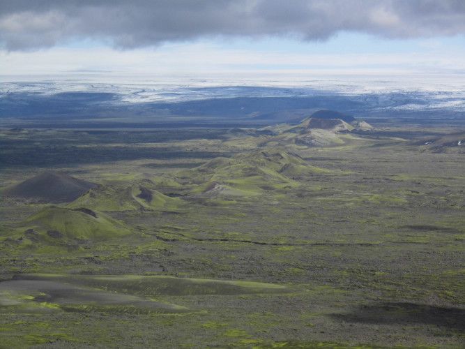
travelled downhill towards the coastal plains. The lava travelled, for the most part, via river beds, mainly through the Skaftá and
     Hversfljót, two glacial rivers that normally flow from Vatnajökull to the Atlantic Ocean. Skaftá (Figure 3), was devoid of water,
     lava lay in its stead. [4]

     This volcanic eruption is known by many names: Its Icelandic name, Skaftareldar, comes from the fact that the eruption took
     place in the Skaftarfellssysla, a region of Iceland, and that it replaced the Skaftá with lava. The crater row is also known as
     Lakagígar, meaning the craters of Laki. The name Laki comes from Mount Laki, a mountain of volcanic origin that did not
     actually erupt in 1783, located roughly in the middle of the fissure (Figure 4). In English, the eruption is mainly known as the
     Laki Fissure eruption. The term “Laki” was suggested by Norwegian geologist Amund Helland almost one hundred years after
     the eruption, it was also chosen for its brevity and easiness to pronounce. Sometimes, it is also referred to as the Laki eruption.

     2. The course of the eruption and the consequences for Iceland
     This lava threatened many Icelanders, their animals, and property. A small number of churches and farmsteads fell victim to the
     lava. Icelanders were able to evacuate before the lava arrived. A very important local chronicler, who kept records on the events
     unfolding in Kirkjubæjarklaustur and what he could observe from a distance about what was happening in the highlands, is Jón
     Steingrímsson. He was a local reverend. He became famous for his autobiography and his “fire treatise,” that described the
     events, and is well known as the “fire priest.” On July 20, 1783, lava crept to within a few meters of his church, in
     Kirkjubæjarklaustur, as he began mass. After his sermon, known as the “fire sermon,” the parishioners were astonished to find
     the lava in the same spot where it had been when mass began. Steingrímsson, it seemed to his parishioners, had prevented the
     lava from engulfing and consuming the church.

     The eruption had produced large amounts of gases and ash too. The gases, particularly the fluorine, poisoned the fields,
     meadows, and ponds. 50% of all the cattle, 79% of the sheep, and 76% of the horses perished between 1783 and 1785, in
     addition to fish in ponds and other animals [5]. In Iceland, the eruption is also remembered by its consequence: The famine of
     the mist, or Móðuharðindin. The Icelandic diet at the time was mainly based on meat and fish, so the fallout of this eruption was
     catastrophic. By 1785, roughly 20 percent of the Icelandic population had perished—from hunger, malnutrition, or diseases.

     Iceland was under a Danish trade monopoly, which meant that only certain Danish merchants were allowed to trade with
     Iceland at specific trading posts around the country. Usually, these merchants arrived in the spring and left in late summer or
     early autumn. News about the volcanic eruption reached Copenhagen in early September 1783, and so, the Danish king,
     Christian VII, decided to send a party to Iceland to survey the damage caused by the eruption. However, due to adverse weather
     conditions, the surveyors did not arrive until the spring of 1784. It took until the 1810s for the population in Iceland to get back
     to its pre-1783 levels.[6]

     3. Impacts on the world outside of Iceland
     3.1. Extraordinary weather phenomena and signs in the sky
     What makes this eruption so extraordinary is that its impacts reached far beyond the borders of Iceland. The gas was transported
     to Europe via the jet stream, where it became observable as a sulfuric-smelling dry fog. The contemporaries in Europe were
     oblivious to the fact that a volcanic eruption had occurred in Iceland at the same time and was causing this unusual dry fog. The
     most worrisome feature of the summer of 1783 was perhaps the “blood red” coloring of the sun during sunset and sunrise.
     Stars and planets became invisible in the lower degrees above the horizon—very similar to the appearance of smog in large cities
     today.

     In 2010, when Eyjafjallajökull erupted, the world was reminded of Icelandic volcanism and its almost global consequences: The
     plume of ash and gas was carried from Iceland towards Europe via the jet stream, grounding international air traffic for several
     days. Even before the onset of international aviation, Icelandic volcanic eruptions proved troublesome for the outside world.

Encyclopédie de l'environnement                                    4/12                                                  Généré le 16/12/2020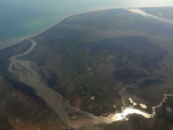
Figure 5. The view from Benjamin Franklin’s terrace in Passy on November 21, 1783. This was the first untethered and manned journey
      of a Montgolfière hot air balloon. Vue de la terrasse de Mr. Franklin a Passi by an anonymous engraver, Paris : Le Vachez : 1783.
      [Source: Bibliothèque nationale de France, département Estampes et photographie, FOL-IB-1. (In the public domain).]

     In early June 1783, two brothers in Annonay, France, had demonstrated the first flight of a hot air balloon (Figure 5). Jacques
     and Étienne Montgolfier named this new invention in their honor, calling it a Montgolfière. The race to the skies had begun: This
     would not remain the last balloon to ascend into the skies in France in 1783. Other inventors, such as Anne-Jean Robert,
     Nicolas-Louis Robert, and Jacques Charles were working on a hydrogen balloon [7]. While the “ballomania” [8] took hold,
     these “flying globes” were not the only unusual phenomenon to occupy the skies and people’s imaginations that year.

     Several extraordinary weather phenomena occurred throughout 1783—the annus mirabilis, the year of awe. Among them, a
     sulfuric-smelling dry fog that lasted for several weeks and that was observable from around June 16 in most parts of Europe and
     beyond. It was visible as far away as Labrador in today’s Canada, Syria, the Lebanon, and even the Altai Mountains on the border
     to China. [9] It varied in density, winds from the northwest seemed to strengthen it, whereas winds from the south seemed to
     disperse it. During the summer of 1783, the contemporaries in Europe were left alone to speculate about the fog’s origin.

     The dry fog was mainly caused by sulfur dioxide (SO2) that had been released during the eruption, the gases are believed to
     have reached an altitude of 9-12 kilometers. Above Iceland, the tropopause is at approximately 8-11 kilometers of altitude. The
     lower level of the atmosphere is called the troposphere and the level above is called the stratosphere. Generally, if volcanic gases
     only reach the troposphere, they are washed out within weeks and there is no long-term impact on the climate. If volcanic gases
     reach the stratosphere, they will remain in the atmosphere for longer and have lasting impacts on the climate, perhaps for up to
     three years. Scientists working on the Laki Fissure eruption are divided on whether most of the Laki gases were able to reach the
     stratosphere. Once the sulfur dioxide reached the tropospause, it was transported towards Europe via the polar jet stream, here
     the sulfur dioxide chemically reacted with the moisture, which produced sulfuric acid (H2SO4). An unusual anticyclonic
     weather pattern above Europe, a quasi-stationary high-pressure cell, funneled the Laki gases down to the surface level, where
     it materialized as a sulfuric-smelling dry fog. [10]

     In addition, the summer of 1783 was hot in north, west, and central Europe. This is particularly unusual, as normally cooling is
     expected after a large volcanic eruption. The heat wave was most likely related to this high-pressure cell. [11]

     The dry fog was peculiar, long-lasting, and may have had some negative impacts on vegetation and human health in mainland
     Europe. A sticky substance was said to have formed on leaves of plants, it was called “honey dew.” Particularly around June
     24-25, in the Netherlands and Northwest Germany, almost over night, plants were heavily affected. Several plants withered,
     leaves changed their color or the trees lost their leaves altogether, but not all species were affected the same. At the same time,
     chemical reactions on metal were observed, structures rusted or turned green. The dry fog hit hardest those suffering from
     pre-existing respiratory or heart issues. In several regions, people complained about sore eyes. There are studies for England
     and France that analyze whether the heat, the dry fog, or several factors together may have caused a higher than usual

Encyclopédie de l'environnement                                    5/12                                                  Généré le 16/12/2020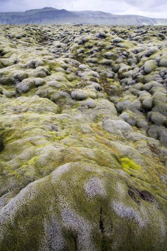
mortality rate in the population. It remains unclear if it was indeed this fog that caused this, or an unrelated outbreak of another
     kind.

     Other contemporary reports argued against the fear mongering: Reports from the eldest community members and close study of
     older chronicles suggested that similar events had occurred in the past and they were always followed by fertile years, indicating
     that there was nothing to worry about. Indeed, the grape harvest of 1783 seemed to have been extraordinarily successful,
     most likely aided by the very warm summer.

     The summer also saw a large number of severe thunderstorms, which brought with them frequent lightning that killed many
     people. The practice of ringing church bells to reroute the storm clouds when thunderstorms were approaching undoubtedly
     helped those figures (clocher de tourmente in French). The recent invention of the lightning rod and a sudden increase in their
     popularity throughout the summer of 1783, led to a law abolishing this practice in many regions [12].

     3.2. Speculation about the cause of the unusual weather

       Figure 6. The earthquake of February 5, 1783. The earthquakes caused severe damage and destruction in Messina (in the foreground)
       and Reggio Calabria (in the background), killing and injuring thousands of residents. [Source: Public Domain]

     The possible explanations for the unusual weather of 1783 were numerous:

     By far the most popular explanation for the presence of the dry fog was the numerous earthquakes that seemed to have
     occurred throughout the year: In February and March 1783, a seismic sequence of five very strong earthquakes shook Sicily and
     Calabria, causing an estimated 30,000 casualties (Figure 6).[13] Other earthquakes occurred throughout the summer: On July 6,
     an earthquake shook parts of France, and was felt in Franche-Comté, the Jura, Burgundy, and Geneva. This earthquake did not
     produce much damage, but it occurred when the dry fog was still dense and wide-spread. Another earthquake occurred on the
     night from August 7 to 8, affecting Northern France, and the areas between Aachen and Maastricht. Another major earthquake
     hit Tripoli, Lebanon, on July 30. [14] Many contemporaries believed they were living in a time of “subterraneous revolution”
     and there were reports of a “newly emerged burning island” that was discovered by fishermen in May 1783 off the coast of
     Iceland. This island was said to have been emitting smoke and surrounded by pumice, floating on the ocean surface, impeding
     sea travel. This island was called Nyey (“new island”) and was fussed over in the news during the summer and almost forgotten
     by the time continental Europe heard of the Laki Fissure eruption. [15]

Encyclopédie de l'environnement                                    6/12                                                 Généré le 16/12/2020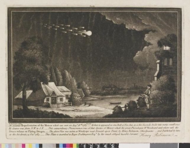
Figure 7. A map of the Earth’s fire canals (Subterraneus Pyrophylaciorum), which he believed to connect all the volcanoes in the world.
      This map is from Athanasius Kircher’s Mundus Subterraneus, 1668. [Source: Public Domain]

     All of these reports of earthquakes gave credence to the idea of a “subterraneous revolution” connecting the “upheavel” in
     Iceland, Calabria, and the Lebanon with one another. It was believed that volcanoes around the world were connected by
     subterraneous canals (Figure 7). There also were reports of a dry fog that occurred just before the first earthquake in Calabria,
     thus spreading fear that this dry fog might only be a harbinger for a large earthquake that was to come. The idea to connect
     earthquakes and the dry fog was probably also aided by the fact that the various hundreds of aftershocks in Calabria and Sicily
     occurred while the dry fog was still visible in southern Italy.

     There also were reports of “fire spitting mountains” that had erupted in three different parts of Germany: The most famous
     one being the Gleichberg in Thuringia. The reports were surprisingly accurate in describing the process of a volcanic eruption
     and it is debatable whether these were genuine explanation attempts to describe the origin of the dry fog locally or whether they
     were clever hoaxes to spread fear. [16] The reports were later retracted after people had visited these areas only to realize the
     extinct volcanoes hadn’t inexplicably sprung back to life. The idea of volcanic eruptions, though, fit very well with the
     above-mentioned theory of a subterraneous revolution.

Encyclopédie de l'environnement                                      7/12                                                   Généré le 16/12/2020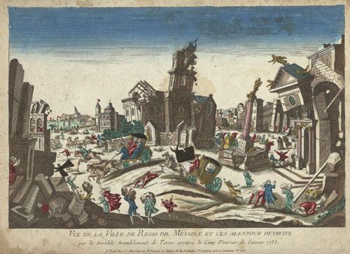
Figure 8. Henry Robinson, “An accurate representation of the meteor“ as seen at Winthorpe, Nottinghamshire, England, on 18 August
       1783. [Source: Henry Robinson / The Trustees of the British Museum. This image is in the online collection of the British Museum. (CC
       BY-NC-SA 4.0).]

     On August 18, 1783, another phenomenon made people turn their heads skyward: A very bright and unusually long-lasting
     meteor, called “the Great Meteor of 1783” was visible from Ireland, Scotland, England, France, Belgium, and the Netherlands
     (Figure 8). At the time, an extraterrestrial origin of meteors was not yet widely accepted: There was no clear distinction between
     meteors and comets. Meteors were believed to be either produced by vapors in the atmosphere or by electricity in the upper
     atmosphere, similar to the phenomenon of the northern lights. [17] Benjamin Franklin, the American ambassador to the United
     States, naturalist, and inventor, who was in Paris at the time, speculated whether “the tails of these great burning balls” might
     have caused the dry fog.

       Figure 9. The United States delegation at the Treaty of Paris: John Jay, John Adams, Benjamin Franklin, Henry Laurens, and William
      Temple Franklin, as depicted by Benjamin West. The British delegation refused to pose, which is why the painting was never completed.
      [Source: Benjamin West [Public domain]]

     Benjamin Franklin further speculated, in May 1784, that there also was a connection between the dry fog and the extremely cold
     winter of 1783/1784. The winter had been extraordinarily cold, not only in Europe, but also in North America. In Europe,
     there was heavy snow, which resulted in major floods along several central and western European rivers in February and March
     of 1784. In Germany, the water levels of late February 1784 produced the highest or second highest flood markers ever recorded

Encyclopédie de l'environnement                                      8/12                                                   Généré le 16/12/2020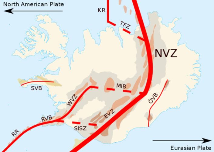
for some regions. [18] In North America, the winter was unusually long, was rich in snow, and even froze the Mississippi river at
     New Orleans and created ice floes in the Gulf of Mexico. [19] The severe winter conditions made it difficult to assemble enough
     congress members in Annapolis in order to have a quorum to ratify the Treaty of Paris, which ended the American
     Revolutionary War (Figure 9). Once the quorum was reached and the treaty was ratified, it was difficult to get a passage across
     the Atlantic Ocean in order to bring it to Paris to exchange it with the ratified treaty of the British. [20]

     While the debate about the origin of the dry fog was primarily inspired by the Enlightenment and the thirst for a rational
     explanation, there also were some religious arguments made.

     3.3. Speculation about a connection between the dry fog and icelandic volcanism
     A handful of contemporary naturalists considered a connection between the dry fog and volcanic eruptions in Iceland. Most
     suggested that there might be a connection between the unusual weather phenomena of the summer and either the Nyey eruption
     or the eruption in the Skaftárfellsysla region when they learnt about them in the news in early to mid-September of 1783. The
     first to propose such an idea was Jacques Antoine Mourge de Montredon, a French naturalist, who presented his findings in front
     of the Société Royale des Sciences de Montpellier on August 7, 1783. Christian Gottlieb Kratzenstein, a German naturalist and
     professor for physics at the University of Copenhagen also connected Icelandic volcanism, with which he was familiar, with the
     dry fog. Swiss naturalist H. Guerin also came to a similar conclusion, his findings were published in Neue Zürcher Zeitung on
     November 5, 1783. Johann Rudolf von Salis-Marschlins, also a Swiss naturalist, published his findings on the topic in Der
     Sammler: Eine gemeinnützige Wochenschrift für Büntgen in mid-November 1783. Belgian botanist and baron Eugène de Poederlé
     published a text about his observations made in Brussels in early 1784.

     In May 1784, Benjamin Franklin, who had suggested the dry fog might have been caused by the meteor, also suggested
     alternatively that Icelandic volcanoes—either Nyey or Hekla—might have been responsible. [21] However, all this speculation
     remained just that for a long time.

     4. The search for the origin of the dry fog
     When the news of an Icelandic volcanic eruption reached Denmark, the mystery about the dry fog was not lifted. It was only in
     1794, that Icelandic naturalist and physician Sveinn Pálsson discovered the Laki Fissure in the highlands. Pálsson described
     his discovery in his manuscript, which he sent to Copenhagen, but remained unpublished for financial reasons. In 1879, Icelandic
     geologist Thorvaldur Thoroddsen stumbled upon the manuscript at the Royal Library in Copenhagen and subsequently published
     part of it in 1879. Norwegian geologist Amund Helland also took an interest in this and upon Thoroddsen’s suggestion visited the
     Laki Fissure in 1881, he also drew a map of the craters and lava fields. Thoroddsen visited the fissure in 1894. [22]

     In 1883, another volcanic eruption made global news: In the Dutch East Indies, a volcano called Krakatau produced the loudest
     noise ever recorded, ejected large amounts of gas and ash, and triggered a tsunami. The eruption is estimated to have killed
     35,000 people. Despite Krakatau’s distance from Europe, the news about the eruption spread fast–thanks to the advent of
     telegraphy. [23]

     This large volcanic eruption inspired several scientists into action, who collected information from professional and amateur
     weather observers from all around the world. They realized for the first time that volcanic eruptions can have impacts on the sky
     and weather phenomena far, far away from the actual volcano. In the aftermath of the 1883 Krakatau eruption, colorful sunsets
     and vibrant colors of the sky were observed in Europe and North America. Thus, in the 1880s, the dots between the Laki
     Fissure eruption and the strange haze of the summer of 1783 could finally be connected. [24]

     5. The Laki Fissure today

Encyclopédie de l'environnement                                  9/12                                                Généré le 16/12/2020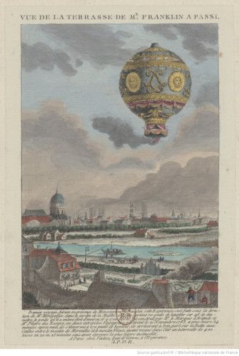
Figure 10. A photo from the center of the Laki Fissure. [Source: Chmee2/Valtameri [CC BY-SA
                         (https://creativecommons.org/licenses/by-sa/3.0)]

     Today, Iceland is an independent country with a population roughly seven times the size it was in 1783. Iceland performs well in
     many indices that measure quality of life, happiness, and equality. Iceland is far from the marginal country it was 250 years ago.
     In the last few decades, Iceland has become a popular tourist destination and Iceland is welcoming record numbers of
     tourists each year. This of course has some environmental consequences.

     The Vatnajökull National Park was established in 2008 and now also incorporates the Laki Fissure (Figure 10). The
     increase in tourism to Iceland also leads to an increasing number of visitors to the fissure. The Laki Fissure is difficult to reach.
     From Kirkjubæjarklaustur it is an eight hour round trip on a four-wheel bus. Although only 50 kilometers from the village,
     traversing bumpy dirt roads, kn

                Figure 11. The moss on the lava fields that were produced by the 1783-1784 eruption. [Source: Onioram [CC BY-SA
               (https://creativecommons.org/licenses/by-sa/4.0)]]

     own as F-roads, takes time. Additionally, the journey requires the fording of several rivers. [25]

Encyclopédie de l'environnement                                    10/12                                                  Généré le 16/12/2020
Sadly, not all tourists respect nature, some leave rubbish behind and others leave the designated pathways. On the
Skaftáreldahraun, the Laki lava field, a very delicate sort of moss is growing, painting the hills around the Laki Fissure with a
lush light green (Figure 11). This moss, due to the altitude and high latitudes, is very sensitive and takes decades to grow. If it is
stepped on, it turns brown and dies. Several warning signs educate visitors and the efforts of volunteer conservationists have led
to wooden paths being built that visitors can step on. [26]
Large flood lava events such as the Laki Fissure eruption have a recurrence time of 300-1000 years. However, in Iceland, the
next volcanic eruption is never far away: On average, Iceland sees a volcanic eruption every 3-5 years. Today, Iceland
monitors its volcanoes carefully and gives locals and travelers a warning to evacuate once the threat of a volcanic eruption is
imminent. It is important to understand the consequences of Icelandic volcanic eruptions on Europe and the northern hemisphere
so that we may act accordingly in the future.
6. Messages to remember
The Laki Fissure eruption of 1783 shows that volcanic eruptions can have impacts on regions far away from the actual volcano.
Sometimes, these effects might be fairly long lasting, even perturbing weather patterns to the extreme.
This extreme event during the Little Ice Age shows how contemporaries dealt with sudden and extreme weather changes, these
lessons may become very useful in our own present and future in a warming world.
Notes et références
Cover image. The southwestern part of the Laki Fissure in Iceland, as seen from Mount Laki. [Source: Photo © Katrin
Kleemann. (Used by permission).]
[1] Thorvaldur Thordarson and Armann Höskuldsson. Iceland. Edinburgh: Dunedin, 2014.
[2] Thordarson, Thorvaldur, and Self, Stephen. “The Laki (Skaftar Fires) and Grimsvotn eruptions in 1783-1785.” Bulletin of
Volcanology 55 (1993), 233–263.
[3] Thordarson, Thorvaldur, and Self, Stephen. “Atmospheric and environmental effects of the 1783–1784 Laki eruption: A
review and reassessment.” Journal of Geophysical Research 108 (2003).
[4] Steingrímsson, Jón. Fires of the Earth. The Laki Eruption 1783-1784, translated by Keneva Kunz, 25-26. Reykjavík:
University of Iceland Press and Nordic Volcanological Institute, 1998.
[5] Oppenheimer, Clive. Eruptions that Shook the World. Cambridge: Cambridge University Press, 2011.
[6] Vasey, Daniel E. “Population, Agriculture, and Famine: Iceland, 1784-1785.” Human Ecology 19, no. 3 (1991):
323-350.1810: 49,000 inhabitants; 1815: 50,000 inhabitants. (accessed on 19 April 2019)
[7] Gillespie, Richard. “Ballooning in France and Britain, 1783-1786. Aerostation and Adventurism.” ISIS 75, no 2 (1984):
249-268.
[8] The term “Ballomania” was used in letter by Joseph Banks to Benjamin Franklin, November 7, 1783. Van Pelt Library,
University of Pennsylvania, VIII, p. 35.
[9] Stothers, Richard. “The Great Dry Fog of 1783.” Climatic Change 32, no. 1 (1996): 79-89.
[10] Thordarson, Thorvaldur, and Stephen Self. “Real-Time Observations of the Laki Sulfuric Aerosol Cloud in Europe During
1783 as Documented by Professor S. P. van Swinden at Franeker, Holland.” Jökull 50 (2011): 65-72.
[11] Zambri, Brian, Alan Robock, Michael J. Mills, and Anja Schmidt. “Modelling the 1783-1784 Laki Eruption in Iceland, Part
Encyclopédie de l'environnement 11/12 Généré le 16/12/2020II: Climate Impacts.” JGR Atmospheres 2019.
[12] Hochadel, Oliver, “‘In Nebula Nebulorum’: The Dry Fog of the Summer of 1783 and the Introduction of Lightning Rods in
the German Empire,” Transactions of the American Philosophical Society 99, no. 5 (2009): 45–70.
[13] Kleemann, Katrin. “Living in the Time of a Subsurface Revolution: The 1783 Calabrian Earthquake Sequence.”
Environment & Society Portal, Arcadia (Summer 2019), no. 30. Rachel Carson Center for Environment and Society.
[14] Demarée, Gaston R., and Astrid E. J. Ogilvie. “Bons Baisers d’Islande: Climatic, Environmental, and Human Dimension.
Impacts of the Lakagigar Eruption (1783-1784) in Iceland.” In History and Climate: Memories of the Future, edited by R. D.
Jones. et al., 219-246. New York: Springer, 2001.
[15] Kleemann, Katrin. “Living in the Time of a Subsurface Revolution: The 1783 Calabrian Earthquake Sequence.” Arcadia:
Explorations in Environmental History, Summer Volume 2019, forthcoming.
[16] Grattan, John, David D. Gilbertson, and A. Dill, “‘A Fire Spitting Volcano in our Dear Germany’: Documentary Evidence
for a Low-Intensity Volcanic Eruption of the Gleichberg in 1783?” The Archaeology of Geological Catastrophe [Geological
Society London, Special Publications] 171 (2000): 307–15.
[17] Beech, Martin. „The Great Meteor of 18th August 1783.” Journal of the British Astronomical Association 99, no. 3 (1989):
130-134.
Payne, Richard J. “Meteors and Perceptions of Environmental Change in the annus mirabilis AD1783-4.” North West Geography
11, no. 1 (2011): 19-28.
[18] Brazdil, Rudolf, Gaston R. Demarée, Mathias Deutsch, et al. “European Floods During the Winter 1783/1784: Scenarios of
an Extreme Event During the ‘Little Ice Age’.” Theoretical and Applied Climatology 100, no. 1-2 (2010): 163-189. Demarée,
Gaston R. “The Catastrophic Floods of February 1784 in and around Belgium—a Little Ice Age Event of Frost, Snow, River Ice
… and Floods.” Hydrological Sciences Journal 51, no. 5 (2006): 878-898.
[19] Ludlum, David M. Early American Winters (1604 to 1820), volumes I and II. American Meteorological Society: Lancaster
Press, 1968.
[20] Dwight L. Smith, "Josiah Harmar, Diplomatic Courier." Pennsylvania Magazine of History and Biography 87.4 (1963):
420–430.
[21] Demarée, Gaston R, and Astrid E. J. Ogilvie. “L’éruption du Lakagígar en Island ou ‘Annus mirabilis 1783’. Chronique
d’une année extraordinaire en Belgique et allieurs.” In Études et bibliographies d’histoire environnementale. Belgique – Nord de la
France – Afrique centrale, edited by Isabelle aprmentier. Actes des 2e RBel, Namur, 2016.
[22] Helland, Amund. Lakis kratere og lavastrømme. Kristiania: Trykt I Centraltrykkeriet, 1886.
Thoroddsen, Th. “De vulkanske Udbrud paa Island I Aaret 1783.” Geografisk Tidskrift 1879.
[23] Winchester, Simon. Krakatoa. The Day the World Exploded. 27th August 1883. London: Viking, 2003.
[24] Symons, George, et al., The Eruption of Krakatoa, and Subsequent Phenomena. London: Harrison and Sons, 1888.
[25] Planning your visit to Laki
[26] Kleemann, Katrin. “Watch your Step! Moss Conservation in Vatnajökull National Park, Iceland.” Seeing the Woods, 18
October 2016.
L’Encyclopédie de l’environnement est publiée par l’Université Grenoble Alpes - www.univ-grenoble-alpes.fr
Pour citer cet article: Auteurs : (2020), The Laki Fissure eruption, 1783-1784, Encyclopédie de l’Environnement, [en ligne
ISSN 2555-0950] url : http://www.encyclopedie-environnement.org/?p=10521
Les articles de l’Encyclopédie de l’environnement sont mis à disposition selon les termes de la licence Creative Commons
Attribution - Pas d'Utilisation Commerciale - Pas de Modification 4.0 International.
Encyclopédie de l'environnement
Powered by TCPDF (www.tcpdf.org)
12/12 Généré le 16/12/2020You can also read