Turtle Mountain Decommission Project, Alberta (NTS 82G): Summary Report and Historical Signs - AER/AGS Open File Report 2018-02
←
→
Page content transcription
If your browser does not render page correctly, please read the page content below
AER/AGS Open File Report 2018-02

                          Turtle Mountain Decommission
                          Project, Alberta (NTS 82G):
                          Summary Report and Historical
                          Signs
AER/AGS Open File Report 2018-02

Turtle Mountain Decommission Project, Alberta
(NTS 82G): Summary Report and Historical Signs

J.A. Yusifbayov, D.E. Wood, D.K. Chao and J.E. Warren

Alberta Energy Regulator
Alberta Geological Survey

April 2018
©Her Majesty the Queen in Right of Alberta, 2018
ISBN 978-1-4601-2689-9

The Alberta Energy Regulator / Alberta Geological Survey (AER/AGS), its employees and contractors
make no warranty, guarantee or representation, express or implied, or assume any legal liability regarding
the correctness, accuracy, completeness or reliability of this publication. Any references to proprietary
software and/or any use of proprietary data formats do not constitute endorsement by AER/AGS of any
manufacturer’s product.

If you use information from this publication in other publications or presentations, please acknowledge
the AER/AGS. We recommend the following reference format:

Yusifbayov, J.A., Wood, D.E., Chao, D.K. and Warren, J.E. (2018): Turtle Mountain Decommission
    Project, Alberta (NTS 82G): summary report and historical signs; Alberta Energy Regulator,
    AER/AGS Open File Report 2018-02, 13 p.

Publications in this series have undergone only limited review and are released essentially as submitted
by the author.

Published April 2018 by:
Alberta Energy Regulator
Alberta Geological Survey 4th
Floor, Twin Atria Building
4999 – 98th Avenue
Edmonton, AB T6B 2X3
Canada

Tel:       780.638.4491
Fax:       780.422.1459
Email:     AGS-Info@aer.ca
Website:   www.ags.aer.ca

                                                    AER/AGS Open File Report 2018-02 (April 2018)    • iii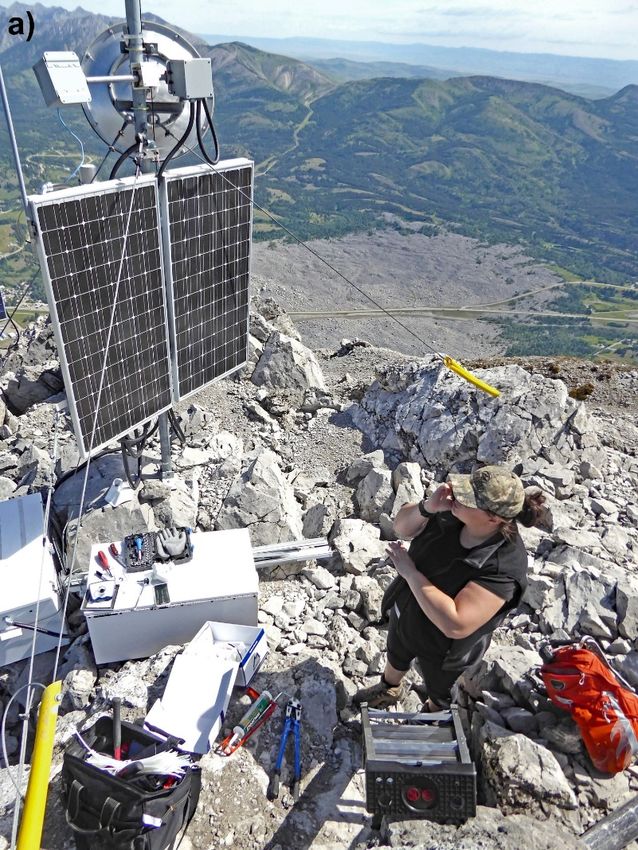
Contents
Acknowledgements ....................................................................................................................................... v
Abstract ........................................................................................................................................................ vi
1 Project Summary ................................................................................................................................... 1
1.1 Background ................................................................................................................................... 1
1.2 Goals ............................................................................................................................................. 1
1.3 Scope of Work .............................................................................................................................. 2
1.4 Project Contributors ...................................................................................................................... 3
2 Decommission....................................................................................................................................... 3
2.1 Web Camera.................................................................................................................................. 3
2.2 Weather Station and Safety Barrels .............................................................................................. 3
2.3 Borehole ........................................................................................................................................ 6
2.4 Crackmeters, Extensometers, and Tiltmeters ................................................................................ 6
2.5 Differential GPS............................................................................................................................ 7
2.6 Clean-up ........................................................................................................................................ 7
3 Outcomes .............................................................................................................................................. 7
3.1 Historical Signs ............................................................................................................................. 7
3.2 Surplus Inventory .......................................................................................................................... 7
4 Conclusion .......................................................................................................................................... 10
5 References ........................................................................................................................................... 13
Table
Table 1. Location and status of Turtle Mountain monitoring equipment ..................................................... 9
Figures
Figure 1. LiSAmobile, overlooking South Peak of Turtle Mountain, Crowsnest Pass, Alberta................... 2
Figure 2. a) Replacement of the South Peak web camera. b) Image from the new South Peak
web camera ................................................................................................................................................... 4
Figure 3. a) AGS field staff dismantling the weather station electronics and instrumentation. b) Non-
operational equipment awaiting removal from Third Peak via helicopter sling ........................................... 5
Figure 4. One of the two safety survival barrels located in the cracks near the weather station .................. 5
Figure 5. AGS field crew dismantling the borehole hub and conduit lines leading to multiple
monitoring-equipment locations ................................................................................................................... 6
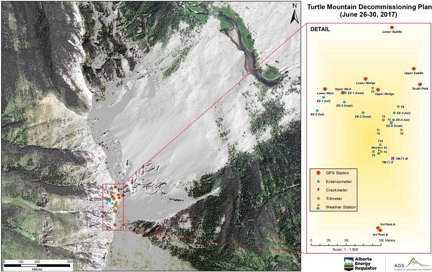
Figure 6. Locations of monitoring equipment on Turtle Mountain, near South Peak .................................. 8
Figure 7. a) Fully assembled dGPS station in 2016. b) Dismantled dGPS station, with only the
cement pillar remaining .............................................................................................................................. 10
Figure 8. Equipment removal from South Peak by helicopter .................................................................... 11
Figure 9. Equipment loaded onto trailers for transportation back to Edmonton ......................................... 12
Figure 10. Sign installed on South Peak commemorating the Town of Frank, devastated by the
Frank Slide of 1903..................................................................................................................................... 12
AER/AGS Open File Report 2018-02 (April 2018) • iv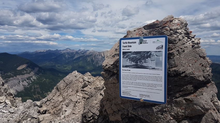
Acknowledgements
We acknowledge the contributions of the following colleagues and collaborators on the Turtle Mountain
Decommission Project:
•   T. Shipman (Alberta Energy Regulator, Alberta Geological Survey, Edmonton, AB)
•   R. Elgr (Alberta Energy Regulator, Alberta Geological Survey, Edmonton, AB)
•   R. Schultz (Alberta Energy Regulator, Alberta Geological Survey, Edmonton, AB)
•   R. Natyshen (Alberta Energy Regulator, Information Management Branch, Edmonton, AB)
•   J. Pawlowicz (Alberta Energy Regulator, Alberta Geological Survey, Edmonton, AB)
•   S. Anderson (Alberta Energy Regulator, Alberta Geological Survey, Edmonton, AB)
•   R. Peters (Ascent Helicopters Ltd., Fernie, BC)
•   G. Bjorgan (NavStar Geomatics Ltd., Kelowna, BC)
•   G. Sivorot (NavStar Geomatics Ltd., Kelowna, BC)
•   É. Talbot-Lanciault (NavStar Geomatics Ltd., Kelowna, BC)
•   M. Field (Government of Alberta, Frank Slide Interpretive Centre, Crowsnest Pass, AB)
•   J. Ambrosi (Government of Alberta, Frank Slide Interpretive Centre, Crowsnest Pass, AB)
•   M. Sagrafena (Government of Alberta, Frank Slide Interpretive Centre, Crowsnest Pass, AB)
•   B. Reilly (Alberta Energy Regulator, Emergency Management, Calgary, AB)
•   J. Martens (Alberta Energy Regulator, Emergency Management, Edmonton, AB)
•   G. Schroter (Alberta Energy Regulator, Emergency Management, Edmonton, AB)
•   M. Zamin (Alberta Energy Regulator, Emergency Management, Edmonton, AB)
•   D. Howlader (Government of Alberta, Alberta Emergency Management Agency, Edmonton, AB)
•   S. Shrubb (Government of Alberta, Alberta Emergency Management Agency, Edmonton, AB)
•   R. Tonowski (Government of Alberta, Alberta Emergency Management Agency, Edmonton, AB)
•   Alberta Emergency Management Agency (Government of Alberta, Edmonton, AB)
•   P. Thomas (Municipality of Crowsnest Pass, Crowsnest Pass, AB)
•   Municipality of Crowsnest Pass Council (Crowsnest Pass, AB)

                                                      AER/AGS Open File Report 2018-02 (April 2018)   • v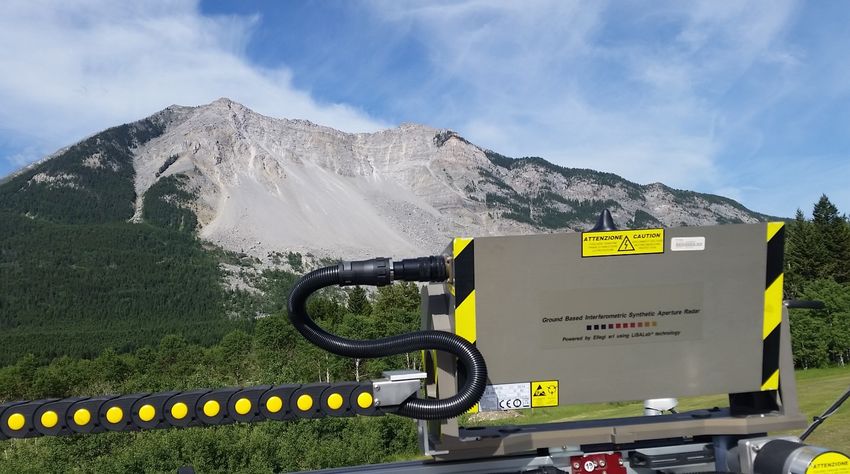
Abstract
The Turtle Mountain Monitoring System (TMMS) is a near-real-time remote monitoring system that
provides data from a network of sensors located at Turtle Mountain in the Crowsnest Pass, site of the
1903 Frank Slide. As of April 1, 2005, the Alberta Energy and Utilities Board, now the Alberta Energy
Regulator (AER), through the Alberta Geological Survey (AGS), took ownership of this system and
manages the Turtle Mountain Monitoring Program (TMMP). In July 2016, the TMMP transitioned from a
near-real-time early warning system to a near-real-time remote monitoring system.
The TMMP conducts ongoing monitoring of Turtle Mountain’s unstable eastern slopes, including an
annual detailed review of the TMMS data stream. To help with this interpretation, the AGS has completed
specific studies to better understand the structure of the mountain and its relationship to the style and rate
of movement seen in recent and historical deformations of South Peak. These studies also better define
the unstable volumes of rock from the South, North and Third Peak areas.
This report provides information about the AER/AGS’s ownership of the TMMS and serves as a
historical record regarding the decommissioning of non-operational instrumentation on Turtle Mountain
in June 2017. The objectives during the decommissioning of inactive equipment also included the
installation of historical signs on South Peak, with the aim of educating hikers on the legacy of the
TMMS from more than a decade of monitoring.

                                                      AER/AGS Open File Report 2018-02 (April 2018)     • vi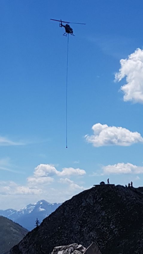
1 Project Summary
The purpose of the Turtle Mountain Decommission Project (TMDP) was to remove non-operational
instrumentation and equipment located on Turtle Mountain. The addition of historical signs on South
Peak provides public outreach to commemorate the historical monitoring (2003 to 2015) by the Turtle
Mountain Monitoring System (TMMS). Lastly, the TMMS transitioned the ground-based InSAR (GB-
InSAR), LiSAmobile, to the primary monitoring sensor in 2016. Additional documentation of the
inoperable sensors and Turtle Mountain monitoring transition plan is provided in Wood et al. (2016,
2017a, b).

1.1 Background
In 2005, the AGS assumed responsibility for the long-term monitoring and study of a potentially large,
slowly moving rockslide at Turtle Mountain. The initial priority of this program was to provide an early
warning to the residents of the Crowsnest Pass in the event of a second catastrophic rock avalanche
originating from South Peak. In July 2016, the TMMP transitioned from a near-real-time early warning
system to a near-real-time remote monitoring system.
During the past decade, the AGS has been studying Turtle Mountain and providing on-call staff 24 hours
a day. In July 2013, a one-day workshop about Turtle Mountain was held in Waterton, Alberta to review
the previous decade of monitoring. Following the workshop, an independent panel of international
experts prepared a report (Wood et al., 2016, Appendix 3) for the AGS providing recommendations for
the current and future TMMP. The report outlines the characteristics and hazard assessment of the
mountain site, reviews the early warning system practices, and makes recommendations for the future of
the program. The panel found the risk of a large-scale rockslide to be very low. The transition to a near-
real-time remote monitoring system will eliminate the requirement that staff be on call 24 hours a day
and will allow the AGS to withdraw some non-operational monitoring equipment. More information on
non-operational equipment previously identified by the AGS is provided by Wood et al. (2016, 2017a).
The AGS is still responsible for long-term monitoring and retains the capacity for early warning if
necessary.
In June 2014, the AGS leased a GB-InSAR system known as LiSAmobile (Figure 1) for a one-year
probationary period, giving us time to review the equipment and monitoring system. During this period,
monthly data updates and monitoring reports were produced on a quarterly basis. This one-year pilot
period allowed the AGS to verify that the services and equipment provided by Ellegi Srl. were optimal
for monitoring surface displacements and had the ability to withstand weather extremes in the Crowsnest
Pass (for detailed information on the operation and data collected, see Wood et al., 2016, 2017a).
LiSAmobile continues to collect high-quality data with limited interruptions since installation. In 2016,
the AGS transitioned to using the LiSAmobile system as the primary monitoring system for the TMMS,
with secondary monitoring campaigns selected by the AGS on an annual basis (Wood et al., 2017b). The
AGS will continue to evaluate LiSAmobile and investigate newer forms of monitoring systems for the
Turtle Mountain Field Laboratory (TMFL).

1.2 Goals
The primary goal was to remove non-operational and abandoned instruments and equipment from Turtle
Mountain because of their inoperable state or generation of poor-quality data. Some non-operational
instrumentation may have been collecting sporadic data, but such data are no longer used by the TMFL.
Non-operational instruments were inventoried in 2016 and subsequently decommissioned and removed in
June 2017. All instruments and equipment removed from the mountain were awaiting surplus admission
in the fall of 2017. Remaining items that have no capital asset value will be disposed at a local eco-
station.

                                                     AER/AGS Open File Report 2018-02 (April 2018)   • 1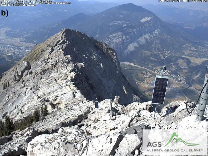
Figure 1. LiSAmobile, overlooking South Peak of Turtle Mountain, Crowsnest Pass, Alberta.

The secondary goal was to work with the Government of Alberta, Frank Slide Interpretive Centre (FSIC)
to create historical signs for members of the public who visit South Peak on Turtle Mountain. These signs
provide information on the historical monitoring program and transition to a near-real-time remote
monitoring system.

1.3 Scope of Work
In-scope work included the removal of low-risk non-operational equipment and restoration of the TMFL
on South Peak to its near-original state. Removal of equipment in high-risk areas, as previously
identified by the Turtle Mountain team during a reconnaissance visit in 2016 was out of scope.
Project constraints were highly variable due to the possibility of harsh weather conditions on Turtle
Mountain. Weather is extremely volatile and difficult to predict. Sudden storms and high winds present
the most substantial complications for the project. Weather is deemed favourable in the early morning,
but massive storms can suddenly develop by early afternoon. The weather was monitored every hour, and
constant communication with the helicopter pilot was mandatory. All field-crew members were prepared
for the possibility of an emergency weather evacuation and were prepared to descend the mountain
quickly by foot or helicopter. Effective communication on the mountaintop was critical between all
members. Flights were determined at the discretion of the pilot for all passenger and slinging flights.
Other constraints included the very loose and brittle rock and unstable terrain found on Turtle Mountain.
All field-crew members were required to read the Turtle Mountain Field Laboratory Safety Manual
(Alberta Geological Survey, 2016) and implement all safety measures while on the mountaintop.
Equipment located in areas of easy to moderate accessibility were decommissioned. Stations that required
special climbing gear or rappelling systems were not removed.

                                                    AER/AGS Open File Report 2018-02 (April 2018)   • 2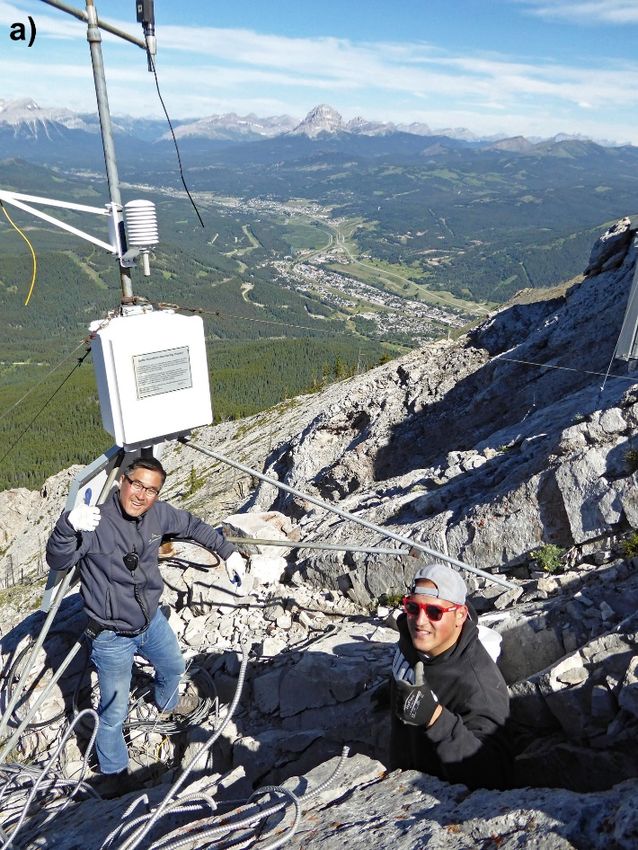
1.4 Project Contributors
Two companies were contracted to provide services and support for the TMDP. NavStar Geomatics Ltd.
was contracted to provide decommission support for the differential GPS (dGPS) stations, and general
clean-up of NavStar equipment. Ascent Helicopters Ltd. was contracted to provide all passenger and
equipment slinging services on the mountain.

2 Decommission
2.1 Web Camera
One group of two AGS employees was tasked with the replacement of the web camera located at South
Peak (Figure 2a). The previous Mobotix M22 camera was replaced with a newer M25 model. The
decision to replace the web camera was based on several reoccurring issues with the older M22 model,
including:
•   poor image quality as a result of low megapixels and outdated technology,
•   constant unexplained reboots of the camera, and
•   inadequate communication transmissions to the AER network.
Replacement of the web camera installation was straightforward, with the new camera solving the above
problems and producing a higher quality video stream (Figure 2b).

2.2 Weather Station and Safety Barrels
The second group focused on disassembling the weather station and replenishing the safety supplies in the
safety barrel. The weather station is located on the west side of the ridge crest, approximately 3 m below
the hiking path connecting South and Third Peaks. As seen in Figure 3a, the weather station is attached to
a 3 m high extended tripod that is secured to the rock face with steel cables. It houses instrumentation
such as a wind monitor, solar radiation probe (pyranometer), temperature/relative humidity probe, solar
panel, batteries, and a plastic enclosure for multiplexors, dataloggers, barometer, and a transmission radio.
This instrumentation collected and transmitted data on rainfall, wind direction and speed, temperature,
and barometric pressure to complement data collected by other components of the monitoring system on
the mountain.
The decommissioning of the weather station began with the detachment of the power supply and removal
of the electrical cables that were connecting batteries with the solar panel and instruments. After the
electronic equipment was disconnected, batteries were removed from their protective enclosure and
transported to the nearest slinging area (Figure 3b). The rock temperature probe could not be safely
accessed, so its conduit was cut as close to the source as possible and the probe was left untouched.
Cleanup at the site included removal of a metal tool chest and such smaller items as electrical wiring,
nuts, and bolts. Conduit and other long electrical wires were rolled up and taped for safe transportation by
helicopter.
The tripod structure for the weather station (including steel tension cables), solar panels, wind monitor,
and the empty plastic enclosure were left behind as part of the educational display for the public on the
history of the TMMP.
If hikers or visitors become stranded on top of Turtle Mountain as a result of injury, fatigue, or change in
weather conditions, they can access a survival kit housed in two blue waterproof plastic safety barrels
near the weather station, one of which is shown in Figure 4. The kit includes items such as a utility knife,
utensils, broadcast radio, flashlight, batteries, blankets, sleeping bags, waterproof matches, water and
purification tablets, wick candles, camp stove with fuel, heat packs, and basic first-aid kit.

                                                      AER/AGS Open File Report 2018-02 (April 2018)     • 3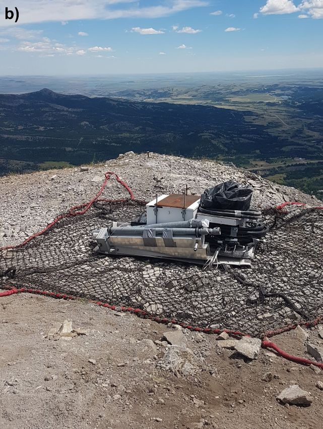
Figure 2. a) Replacement of the South Peak web camera. b) Image from the new South Peak web
camera.

                                              AER/AGS Open File Report 2018-02 (April 2018)   • 4
Figure 3. a) AGS field staff dismantling the weather station electronics and instrumentation.
b) Non-operational equipment awaiting removal from Third Peak via helicopter sling.
Figure 4. One of the two safety survival barrels located in the cracks near the weather station.
AER/AGS Open File Report 2018-02 (April 2018) • 5These survival barrels also contain an approximately 48-hour supply of high-energy food rations for two
people (or four people for 24 hours), including instant coffee and soup packages, hot chocolate, mixed
nuts, sugar, and granola bars. All consumables are vacuumed sealed, and most of them will not expire
until 2020. All expired rations, such as granola bars and mixed nuts, were removed and replaced with a
fresh stock. An inventory of the emergency barrels was conducted and the internal inventory was updated
to reflect these changes in the Turtle Mountain Field Laboratory Safety Manual (Alberta Geological
Survey, 2016) in 2017.
2.3 Borehole
The third group focused on dismantling the borehole, located approximately 10 m below the South Peak
monitoring station. As seen in Figure 5, the borehole station consisted of a solar panel, battery boxes,
dataloggers, multiplexors, and a wireless router, which served as the data collection and transmission site
for the monitoring sensors: crackmeters, extensometers, and tiltmeters.
To decommission the station, the battery and solar panel were disconnected, followed by all sensor
connections. The dataloggers, multiplexors, and the router were left in the enclosure for ease of transport.
The conduit housing the wires to each of the external sensors was then disconnected from the metal
enclosure. Once all connections were severed, the guy-wires were loosened and the main mast was
disconnected. When the mast was free, the enclosure and solar panel were separated from the mast to
prepare them for slinging.
2.4 Crackmeters, Extensometers, and Tiltmeters
The remaining AGS crew was responsible for dismantling the crackmeters, extensometers, and tiltmeters.
All 22 crackmeters remain on the mountain due to their remote and concealed locations. Four surface-
wire extensometers and seven tiltmeters were removed from the mountain due to their relative ease of
access.
Figure 5. AGS field crew dismantling the borehole hub and conduit lines leading to multiple
monitoring-equipment locations.
AER/AGS Open File Report 2018-02 (April 2018) • 6An extensometer consists of a narrow metal enclosure at one end and a plastic head at the other, both of
which were cut near the base of the equipment. Tiltmeters consist of a small waterproof enclosure that is
attached to the face of the mountain by two screws. Once disassembled, all of the sensors were brought to
the closest slinging area where conduit was rolled and taped together for safe transportation. The
remaining two extensometers and three tiltmeters remain as part of the educational display for the public
on the historical monitoring program. Locations of the monitoring sensors on Turtle Mountain are shown
in Figure 6 and the exact co-ordinates of the sensors are provided in Table 1.
2.5 Differential GPS
Three employees from NavStar Geomatics Ltd. were responsible for decommissioning the dGPS network
of sensors. Each of these stations consists of three parts: a GPS antenna mounted on a concrete pillar, an
electronic box containing batteries and telemetry instruments, and a solar panel providing power to the
station. Six out of ten stations were disassembled due to their ease of access. Station removal included
dismantling the GPS antennas, solar panels, and electronic boxes, and removing all conduit cables from
the station, leaving only the concrete pillar in place. The remaining four stations are considered out of
scope, due to their locations; therefore, only the battery enclosures, electronics, and conduit were
removed. Figure 7a shows a fully assembled dGPS station, while Figure 7b shows a partially dismantled
station that was left as part of the educational display for the public on the historical monitoring program.
2.6 Clean-up
One of the critical components of the decommission project was the clean-up and transportation of the
equipment from the mountaintop to the valley below. Several locations on the mountain were selected as
slinging and staging areas. They were chosen according to their relative flatness, ease of access for the
helicopter, lack of trees, and general visibility from the surroundings (Figure 8).
Due to the potential risks of the operation, constant communication between the helicopter pilot and the
field leaders was mandatory. To further increase everyone’s safety, a limited number of employees were
allowed to be near the slinging area and responsible for equipment loading. All employees were required
to wear safety vests for maximum visibility from the helicopter.
A group of three field-crew members was located at the base of the mountain and responsible for
unloading the cargo nets, organizing materials, and packing the trailers according to the Turtle Mountain
Field Laboratory Safety Manual (Alberta Geological Survey, 2016). Final packing of the trailers is shown
in Figure 9.
The remaining field-crew members were responsible for the final clean-up of the mountain, which
involved picking up screws and bolts misplaced while the equipment was being dismantling, picking up
garbage left by hikers, and cleaning and organizing the equipment awaiting pickup from the helipad.
3 Outcomes
3.1 Historical Signs
Six historical signs were created in collaboration with the Frank Slide Interpretive Centre (FSIC) that
provide information and education to hikers on the historical monitoring equipment that remains in place.
The signs were printed on aluminum, weather-resistant material and attached to rocks on South Peak
(Figure 10) with weather-resistant bolts. Sign locations were chosen with the FSIC for ease of access to
hikers.
3.2 Surplus Inventory
All decommissioned items were brought back to the AER/AGS Mineral Core Research Facility (MCRF)
for either surplus as capital/noncapital assets or to repurpose for other use at the AGS. Items for surplus
AER/AGS Open File Report 2018-02 (April 2018) • 7Figure 6. Locations of monitoring equipment on Turtle Mountain, near South Peak.
AER/AGS Open File Report 2018-02 (April 2018) • 8Table 1. Location and status of the Turtle Mountain monitoring equipment. Decommissioned
stations were either partially decommissioned (e.g., dGPS stations), leaving only concrete pillars,
or fully disassembled (e.g., extensometers, and tiltmeters). Various pieces of equipment were left
as historical examples of monitoring due to their inaccessibility. The weather station was also
partially decommissioned, leaving the external structure behind. All of the crackmeters remain on
the mountain due to their inaccessibility. Remaining historical stations have had their electronics
and batteries removed.
Location
Monitoring Network Station Name Station Status
Latitude Longitude
Ridge 49.57660 –114.40786 Historical
Upper Wedge 49.57904 –114.41256 Decommissioned
Lower Wedge 49.57918 –114.41272 Decommissioned
Upper West 49.57900 –114.41301 Decommissioned
Lower West 49.57905 –114.41324 Decommissioned
Differential GPS
South Peak 49.57911 –114.41202 Historical
Upper Saddle 49.57931 –114.41210 Historical
Lower Saddle 49.57984 –114.41238 Historical
3rd Peak A 49.57726 –114.41256 Decommissioned
3rd Peak B 49.57723 –114.41253 Decommissioned
EX-1 (head) 49.57900 –114.41298 Decommissioned
EX-1 (tail) 49.57894 –114.41326 Decommissioned
EX-2 (head) 49.57874 –114.41275 Historical
EX-2 (tail) 49.57896 –114.41334 Historical
Extensometers
EX-3 (head) 49.57888 –114.41299 Decommissioned
EX-3 (tail) 49.57874 –114.41235 Decommissioned
EX-4 (head) 49.57865 –114.41236 Historical
EX-4 (tail) 49.57861 –114.41239 Historical
T1 49.57870 –114.41278 Decommissioned
T2 49.57865 –114.41249 Historical
T3 49.57906 –114.41263 Decommissioned
T4 49.57824 –114.41252 Decommissioned
T5 49.57824 –114.41262 Decommissioned
Tiltmeters
T6 49.57852 –114.41226 Decommissioned
T7 49.57862 –114.41239 Decommissioned
T8 49.57852 –114.41256 Decommissioned
T9 49.57882 –114.41230 Historical
T10 49.57833 –114.41253 Historical
AER/AGS Open File Report 2018-02 (April 2018) • 9Figure 7. a) Fully assembled dGPS station in 2016. b) Partially dismantled dGPS station, with only
the cement pillar remaining.
included functioning equipment from the mountain, such as solar panels, batteries, conduit and various
sensors. The metal and plastic enclosures that housed the electronics on the mountain were stored at the
MCRF, with the intent of being used in future by the AGS.
4 Conclusion
Recent application of modern characterization, monitoring, and modelling technologies has
dramatically increased our understanding of the existing rock-slope hazard at Turtle Mountain. The
successful decommissioning of non-operational instrumentation on Turtle Mountain concludes the
transition from a mountain-based early warning system to a remote monitoring system.
The AGS will continue to investigate different forms of monitoring systems for the TMFL and will
continue to provide primary, secondary, and tertiary monitoring. This report is written for historical
education and is accurate to the best of our knowledge.
AER/AGS Open File Report 2018-02 (April 2018) • 10Figure 8. Equipment removal from South Peak by helicopter.
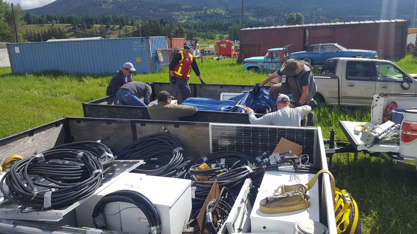
AER/AGS Open File Report 2018-02 (April 2018) • 11Figure 9. Equipment loaded onto trailers for transportation back to Edmonton.
Figure 10. Sign installed on South Peak commemorating the Town of Frank, devastated by the
Frank Slide of 1903.
AER/AGS Open File Report 2018-02 (April 2018) • 125 References
Alberta Geological Survey (2016): Turtle Mountain Field Laboratory Safety Manual; Alberta Energy
Regulator, AER/AGS unpublished manual, 73 p.
Wood, D.E., Chao, D.K. and Shipman, T.C. (2016): Turtle Mountain Field Laboratory, Alberta (NTS
82G): 2014 data and activity summary; Alberta Energy Regulator, AER/AGS Open File Report
2015-10, 91 p. URL [October 2016].
Wood, D.E., Chao, D.K., and Shipman, T.C. (2017a): Turtle Mountain Field Laboratory, Alberta (NTS
82G): 2015 data and activity Summary; Alberta Energy Regulator, AER/AGS Open File Report
2017-03, 21 p. URL [September 2017].
Wood, D.E., Chao, D.K., Guo, J.F. and Shipman, T.C. (2017b): AER/AGS Roles and Responsibilities
Manual for the Turtle Mountain Monitoring Program, Alberta; Alberta Energy Regulator, AER/AGS
Open File Report 2017-04, 38 p. URL< http://ags.aer.ca/publications/OFR_2017_04.html>
[September 2017].
AER/AGS Open File Report 2018-02 (April 2018) • 13You can also read