WATERFRONT: PAST AND PRESENT WATERSCAPES OF TOORADIN AND KOO WEE RUP SWAMPLAND
←
→
Page content transcription
If your browser does not render page correctly, please read the page content below
WATERFRONT:
PAST AND PRESENT WATERSCAPES OF TOORADIN AND
KOO WEE RUP SWAMPLAND

PRIMER:
A selection of readings about the landscape of the old swamplands of Koo Wee Rup and the
coastal shores of Tooradin and Westernport.

Compiled by Monash Urban Lab

Waterfront is proudly presented by Centre for Architecture Victoria | Open House Melbourne, in partnership with
DELWP and East Gippsland Shire Council. Waterfront is part of Melbourne Design Week 2021, an initiative of
the Victorian Government in collaboration with the NGV.
CONTENTS:

                                                                                                      MAP FOR A VANISHED LANDSCAPE BY LIAM DAVISON                                           p.6
                                                                                                      Davison, Liam. “Map for a Vanished Landscape.” Griffith Review, 44 (2014):
                                                                                                      https://www.griffithreview.com/articles/map-for-a-vanished-landscape/

                                                                                                      THE SWAMPY LOWLANDS OF MELBOURNE BY CATHERINE MURPHY                                  p.23
                                                                                                      AND NIGEL BERTRAM
                                                                                                      Murphy, Catherine, and Nigel Bertram. “The Swampy Lowlands of Melbourne”. In
                                                                                                      In Time With Water: Design Studies of 3 Australian Cities, edited by Nigel Bertram
                                                                                                      and Catherine Murphy, 79-153. Perth: UWAP, 2019.

                                                                                                      ECOLOGY OF THE KOOWEERUP SWAMP AND ASSOCIATED                                         p.42
                                                                                                      GRASSLANDS BY JEFFREY YUGOVIC
                                                                                                      Yugovic, Jeffrey. “Ecology of the Kooweerup Swamp and associated grasslands.”
                                                                                                      Proceedings of the Royal Society of Victoria, no 123 (2, 2011): 172-188.

                                                                                                      WESTERNPORT BAY, FRENCH ISLAND AND PHILLIP ISLAND BY ERIC                             p.63
                                                                                                      C. F. BIRD
                                                                                                      Bird, Eric C.F., The Coast of Victoria: The Shaping of Scenery, Carlton.: Melbourne
Source: Monash Urban Lab                                                                              UniversityPress, 1993, 192-231.
COMPILED BY:
Monash Urban Lab
Department of Architecture
Monash University
https://www.monash.edu/mada/research/monash-urban-lab

For research purposes only. Copyright held by authors or publishers.
Except as permitted by the Copyright Act, no part of the material in this reading primer may be re-
produced in print or reproduced or utilised in any digital or printed form, without permission from
the authors or publishers, as listed below.
Source: Monash Urban Lab
6 7
8 9
10 11
12 13
14 15
16 17
18 19
Source: Monash Urban Lab
22 23
24 25
26 27
28 29
30 31
32 33
34 35
36 37
38 39
Source: Monash Urban Lab
ECOLOGY OF THE KOOWEERUP SWAMP AND ASSOCIATED GRASSLANDS                                   173

                                ECoLogy of ThE KoowEERuP SwAmP
                                   AND ASSoCiATED gRASSLANDS

                                                   Jeffrey V. yugoVic
                                Biosis research, 38 Bertie Street, port melbourne, Victoria 3207

            yugoVic, J.V., 2011. ecology of the Kooweerup Swamp and associated grasslands. Proceedings of the
                 Royal Society of Victoria 123(2): 172-188. iSSN 0035-9211.
                 an understanding of the ecology of the Kooweerup Swamp is obtained from historical maps and
            survey plans and modern soil mapping. The probable boundary of the former largest swamp in Victoria is
            determined. The immense swamp had distinct zones formed by inner and outer swamps: the inner swamp
            was a permanently inundated reedswamp with emergent sand ridges and a descending series of lake-like
            cells, while the fringing outer swamp was largely paperbark scrub subject to frequent flooding. grassland
            and Acacia woodland were locally extensive adjacent to the swamp in areas of periodic flooding. The inner
            swamp boundary was probably flood controlled while the outer boundary was probably fire controlled on
            the plains and topographically controlled by hills to the east. Small areas of swamp scrub and grassland
            remain, with significant examples at The inlets in Koo wee Rup.

            Key words: Kooweerup, Koo wee rup, Koo-wee-rup, swamp, grassland

     The Kooweerup Swamp, also known as The                         official place name of the town on the former edge of
     Great Swamp, The Great marsh and Kuwirap, was                  the swamp.
     the largest swamp in Victoria (Fig. 1). Draining and               The Kooweerup Swamp was effectively impass-
     clearing the immense swamp for agriculture was a               able and formed part of the boundary between the in-    Fig. 1.   The Great Swamp, map of Australia Felix (Ham 1849).
     major undertaking commencing in 1876 and con-                  land woi wurrung and the coastal Bun wurrung peo-
     tinuing in stages to 1962, imposing hardship on                ple. The northern edge was inhabited by the Bulug
     early settlers and drainage workers. The major drain           willam clan, meaning ‘swamp dwellers’ from buluk        case of Urquhart (1847), Mount Ararat and Cannibal       Plan Rail 84C2 (1873)
     is the Bunyip main Drain which was constructed in              = swamp and willam = dwelling place. The southern       Hill. Swamp and grassland boundaries were digitally      Railway survey map of the eastern swamp edge from
     1889–1893 and later enlarged. There have been sev-             edge was inhabited by the Yallock balug clan of the     traced and combined on one composite map.                Garfield to Yannathan, uniquely covers a large area
     eral attempts to drain the swamp during which time             Bun wurrung, meaning ‘river people’ from yallock =          Map data and information sources were:               but relatively small scale.
     there have been at least 14 floods. The Cora Lynn              river and bulluk = people (Clark 1990).                 Survey map of Urquhart (1847)                            Map of Torbonarach and Red Bluff (Moore and Mar-
     spillway, constructed in 1962, was the last major                  In order to understand this unique ecosystem        Map of the western and northern edge of the swamp        tin’s Yallock stations)(no date)
     drainage project (roberts 1985) but the swamp is not           and locate remnant vegetation, historical sources are   and adjacent open plains from Tooradin to Garfield,      Sketch map of the Yallock area in Gunson (1968), not
     entirely tamed as there have been significant floods           used here to map the outer boundary of the swamp.       remarkable detail with chainage points shown, with       to scale but informative.
     since then. The natural swamp was destroyed without            Soil mapping allows a glimpse of the inner swamp.       annotations on vegetation.                               Map of land subsidence of Hills (1942)
     any detailed account of its original condition (hills          Further analysis is in Yugovic and mitchell (2004,      Survey map of Foot (1855)                                Remarkable map of early land subsidence, overlaying
     1942) so what is known of its ecology is based on              2005). This paper updates and expands upon Yugovic      Map of the southern swamp edge from The Inlets           early contours with 1914 contours. Subsidence was
     fragmentary and often indirect evidence.                       and mitchell (2006) and includes a clear map of the     to Yallock, shows crown allotments allowing better       due to shrinkage and loss of up to about eight feet of
          The aboriginal name Kuwirap is said to mean               reconstructed swamp boundary.                           resolution and registration with the base map, with      peat from drainage, fires, wind erosion, compaction
     ‘blackfish swimming’, from kowe = water and wirap                                                                      annotations.                                             and oxidation. The distribution of the former peat
     or werup = blackfish (Database of Aboriginal Pla-                                                                      Survey map of Callanan (1859)                            deposit is assumed to indicate the extent of the inner
                                                                                         meThoDS                            Map of the northern swamp edge from Cardinia to          swamp. Points where contour lines from the two
     cenames of Victoria 2002). Surveyor william ur-
     quhart (1847) recorded the name of the swamp. his                                                                      Pakenham, shows allotments, with annotations.            surveys converge indicate no subsidence and the
     field book states that the swamp was called ‘Cowir-            Copies of historical and maps survey plans were         Plan K118 (1866)                                         edge of the deposit. Coverage is not complete so the
     rip’ by the ‘Natives’. The name of the swamp is                obtained from Land Victoria and the State Library       Map of the southern swamp edge in the Yallock area,      entire deposit is not indicated. Map also appears in
     spelt in several ways. Kooweerup and Koo-wee-                  of Victoria. mapping was undertaken using GIS           shows allotments, with annotations.                      Hills (1975).
     Rup are official historical place names. The spelling          software. plans were scanned and registered as          Plan L3335 (1866)                                        Soil map of Sargeant et al. (1996)
     Kooweerup is more in keeping with the aboriginal               accurately as possible, using reference points such     Map of the near-coastal swamp edge and The Inlets,       Primary source on the extent of the former peat
     name and is applied here. Koo wee rup is now the               as creek alignments, land boundaries and, in the        shows allotments, with annotations.                      deposit and thus the inner swamp. Map units Koo-
                                                              172

42                                                                                                                                                                                                                                            43
174 J. YUGOVIC
Wee-Rup peaty clay (Ko) and Koo-Wee-Rup peaty boundary is inferred from soil mapping and is
clay with sandy ridges (Ko/sr) indicate the former indicative only.
extent of peat (I. Sargeant pers. comm.). These soils The Koo Wee Rup Plain included a number of
are developed on alluvial deposits that pre-date the swamp complexes (Rosengren 1984):
swamp. Apart from some of the higher sandy ridges, • Kooweerup Swamp
these deposits were below the original peat layer and • Dalmore Swamp, contiguous with above, to the
now incorporate ploughed-in residue from the peat, west
hence the description ‘peaty’ (Hills 1942; Goudie • Tobin Yallock Swamp, effectively separate from
1942). both of the above, to the south
Hills (1942) indicates a larger area of peat Grasslands and woodlands were locally extensive on
deposit but Sargeant et al. (1996) is adopted for the the margins of these swamps.
inner swamp boundary due to its complete coverage;
however, soil map units Ko and Ko/sr may represent
Kooweerup Swamp
a minimum estimate. The present organic or peaty
content of soil is expected to be lower towards the
edge of the former peat deposit where the overlying The Kooweerup Swamp was joined with the Dal-
peat would have been shallow. Marginal areas of more Swamp to form a major wetland complex with
Monomeith clay loam and Narre clay loam, which an east-west orientation. With maximum dimensions
have normal amounts of organic matter, may have of 32 km and 14 km and 30 000 ha in area, this was
had shallow peat although it was ‘no more than a few by far the largest swamp in Victoria.
inches’, and the transition from peaty clay to clay The swamp was situated on the Koo Wee Rup
loam is very gradual (Goudie 1942: 103). Plain, the northern and terrestrial part of the Western
Swampy riparian woodland is indicated in the Port Sunkland which is a product of block faulting
mapping along the Bunyip River before it enters the (Spencer-Jones et al. 1975). The swamp formed after
inner swamp and along Yallock Creek after it leaves the last Ice Age in what had been an arid or semi-arid
the inner swamp. The woodland is modelled in order landscape. A previously dry climate is indicated by
to complete the map, all other data being sourced wind-formed curved ridges (lunettes) on the east side
from existing maps. The notional width of woodland of former intermittent lakes (Sargeant et al. 1996).
is approximately 100 m on each side of the stream With climate warming there was more rainfall and
based on the example at Bayles, while the old course permanent flow in the Bunyip River. Permanent in-
of the Bunyip River is unclear. undation of the inner swamp initiated peat deposi-
tion which was continuous up to the time of drainage
(Hills 1942).
RESULTS AND DISCUSSION Sea level rise following the Ice Age truncated the
swamp, greatly reducing its size. Freshwater swamp
Historical maps and survey plans and modern soil deposits outcrop along the coast as low cliffs be-
mapping are combined to delineate the original inner tween The Inlets and Lang Lang beach (Gell 1974;
and outer boundaries of the Kooweerup Swamp in Rosengren 1984). Peat deposits also have been traced
Fig. 2. The outer boundary is taken to be the mapped below the mudflats of Western Port Bay where they
edge of Swamp Paperbark Melaleuca ericifolia scrub. are exposed in tidal channels. Peat 0.5 m above the
Where there are discrepancies between sources, the base of the freshwater swamp deposit on the floor of
best source in terms of resolution is given priority. the bay was dated 12 280 to 13 480 years BP. Given
Where no data is included, along small sections of the age of the peat sample and its location relative to
the outer boundary, no line is indicated. the base of the deposit, it is likely that initial deposi-
The scale and accuracy of the reconstructed tion began around 14–15 000 years BP. Prior to the
swamp boundary varies with the source data. Source marine incursion, the Kooweerup and Tobin Yallock
maps such as Foot (1855) are remarkably detailed Swamps extended well onto the present floor of the
and probably accurate to within tens of metres, while bay where they merged to form a large swamp for
other maps are at smaller scales and one is not to several thousand years (Miles 1976).
scale. The outer swamp boundary is a compilation The fall of the swamp decreased towards the
of historical maps and survey plans, while the inner coast, as the fall of the main drain ranges from 1.9
44 45176 J. YUGOVIC ECOLOGY OF THE KOOWEERUP SWAMP AND ASSOCIATED GRASSLANDS 177
m/km near Bunyip to 0.6 m/km in the lower reaches with deep peat probably existed between Cora Lynn main outlet was Yallock Creek which issued from the An island in the swamp occurred at Tynong where
(Hills 1942). This is due to the shape and size of the and Catani (Goudie 1942). Groundwater moved more southern edge of the inner swamp at Bayles and was a low granite hill had become surrounded by swamp
old alluvial fan of the Bunyip River that lay under the slowly through the peat and, in effect, the swamp was essentially the lower course of the Bunyip River which (Fig. 2). The description on Urquhart’s map is ‘island
swamp (Goudie 1942). a gigantic sponge with large volumes of water slowly entered the inner swamp in the north-east (Rosengren heavily timbered with gum and dense scrubs’ sug-
The outer swamp consisted primarily of closed moving through, with increased surface flows during 1984). Natural levees lining the creek supported gesting lack of fire. At Tynong there was an abrupt
scrub 4–6 m in height and dominated by the shrub floods. riparian eucalypt woodland; a priceless example is sequence from grassy eucalypt woodland on granite
or small tree Swamp Paperbark Melaleuca ericifolia Permanent inundation in the centre of the swamp the isolated woodland at Bayles. Yallock Creek and hills to reedswamp on the plain with a fringe of Mela-
(Urquhart 1847 field book). The dense scrub grew on resulted in the deposition of ‘fibrous peat, six to ten its levee woodland meandered through 3 km of scrub leuca and swampy woodland. The extensive view
essentially mineral clay soil rather than the deeper or- feet deep, waterlogged for the most part’ (East 1935: before leaving the outer swamp and passing through from the hills over ‘impenetrable scrubs of Tea Tree,
ganic peat of the inner swamp, as Melaleuca requires 80), consisting of Phragmites and other vegetation woodland and grassland to the coast. According to Gum Scrubs and Reeds’ (Urquhart 1847) included the
drainage and generally does not tolerate permanent not fully decomposed due to anaerobic conditions. Foot (1855: annotation on plan), Yallock Creek ‘runs northern arm reedswamp and the vast inner reeds-
inundation. Melaleuca substrates may develop a Remains of Phragmites, Typha and Melaleuca were the greater part of the year, but towards the end of wamp stretching south-west to the horizon.
shallow peaty surface layer where frequently water- found in remnant peat by Goudie (1942). The peat summer becomes only a chain of ponds’. Hovell, in Two curved ridges of similar orientation on the
logged, and the species may colonise peat during dry also included a small amount of gravel from the January 1827, found the water ‘exceedingly good’. north-west edge of the swamp appear on Urquhart’s
phases when water levels are low. catchment transported into the swamp by water cur- Sand ridges were reportedly used to access the map: the 3 km Rythdale ridge and the 2 km Cardinia
Some areas within the outer swamp, probably rents. Up to 3 m of peat had accumulated over thou- swamp for stock grazing (Hills 1942). Narrow me- ridge (Fig. 2). Five to eight metres above the swamp
mostly localised sand ridges, supported swampy sands of years, and since peat is resistant to erosion andering sandy ridges slightly above the present sur- surface, these features are lunettes that formed on the
woodland of Swamp Gum Eucalyptus ovata with the massive peat deposit acted as a local base level face occur in parts of the swamp area, both inside downwind side of intermittent lakes that were the
Melaleuca understorey, the ‘Gum Scrub’ of Urqu- for streams (Hills 1942, 1975). and outside the area of the former peat deposit. There terminations of creeks (Toomuc and Cardinia Creeks
hart (1847). These sites had more soil aeration and Vegetation patterns, particularly within the inner are two ‘sandy complexes’, in the north and south respectively) under dry Ice Age conditions before the
possibly a higher fire frequency. Sand ridges also im- swamp, were probably intricate. The lake-like cells of the swamp, where sand ridges occupy more than swamp existed (Sargeant et al. 1996). They are dif-
peded drainage, resulting in local reedbeds and wa- postulated by Hills (1942) are likely to have support- 20% of the area, and occasional ridges occur outside ferent in origin from the lower alluvial sand ridges
terholes in the outer swamp (1866 Yallock plan) and ed a mosaic of reedswamp (Phragmites and Typha), these areas (Goudie 1942, Sargeant et al. 1996, Fig. and have state geomorphic significance due to their
there were ‘water channels in places’ (Hills 1942: 79). aquatic sedgeland (including Baumea, Eleocharis 2). Many ridges are now modified by gravel extrac- unusual landform (Rosengren 1984). Both ridges
The presence of natural levees supporting swampy and Schoenoplectus), aquatic herbland (including tion (I. Sargeant pers. comm.) but they were 0.3 to were high ground in the swamp but they did not
riparian woodland including Manna Gum Eucalyptus Azolla and Triglochin) and open water. Emergent 1.5 m high and from a few metres to 20 to 40 m wide reach the inner swamp (the other high ground was
viminalis as evidenced by the remnant at Bayles along sand ridges would have supported paperbark scrub (Goudie 1942). A site with one metre ridges occurs the Tynong island). From remnant vegetation, the
outflowing Yallock Creek within the outer swamp within the inner swamp and eucalypt woodland at Pakenham South (Rosengren 1984). The ridges crest of Rythdale ridge supported grassy woodland
indicates that the entire swamp would flood at times. within the outer swamp, adding to the complexity of are probably abandoned levees and bed deposits of of Manna Gum. The southern tip of the ridge was
The core of the swamp was a very different en- the vegetation. distributary channels of a large alluvial fan made by annotated ‘point of timber’ by Urquhart (1847).
vironment, being relatively open and dominated by The Kooweerup Swamp was fed by about 10 the Bunyip River under more arid conditions prior to A specimen of Leadbeater’s Possum Gymno-
reeds and rushes. ‘Two transects of the swamp made creeks and rivers but mainly by the Bunyip River formation of the swamp (Hills 1942). belideus leadbeateri at Museum Victoria was col-
in 1868 show mainly reeds, rushes, and water where with headwaters in the cool temperate rainforests Judging by the map of early land subsidence lected from the hollow branch of a tree being felled
peat has now been mapped, with a small area of stunt- and Mountain Ash forests of the Central Highlands (Hills 1942), the original surface of the sandy com- at ‘the edge of the Koo-Wee-Rup Swamp long be-
ed tea-tree noted on the eastern edge’ (Goudie 1942: 25 km north. Before it was channelled, the Bunyip plex areas was 0.6 to 2.1 m higher. Given that the fore the swamp was drained, about three miles due
95). Hills (1942) thought the reeds and rushes were River was ‘about 10 feet wide and 5 feet deep’ (Catani ridges were up to 1.5 m high, it follows that some south from Tynong railway station’ (Mason in Bra-
probably Common Reed Phragmites australis and a 1901). It is not clear whether levees lined the river but not all of the ridges were buried under the peat, zenor 1932: 108). This location is within the original
species of Scirpus (this genus was subsequently split before it entered the inner swamp as levees are not which is consistent with some ridges having a peaty swamp but peripheral clearing may have occurred by
into several genera, the species of deep water is River apparent at sites 28 and 29 of Rosengren (1984). All loam soil indicating past coverage by peat while that time. The hollow-bearing tree may have been a
Club-sedge Schoenoplectus tabernaemontani which contributing streams dissipated within the swamp, others do not (Goudie 1942, Sargeant et al. 1996). It Swamp Gum on a sand ridge outcropping above the
would certainly have occurred in the swamp). The the outlets being separate streams. is also likely that ridges in the outer swamp (which peat to the south-west of the Tynong island. A sand
early 1868 survey, which could not be located during Paperbark scrub extended back along the rivers were exposed as there was no peat) extended into the ridge mapped by Rosengren (1984) may have been
this study, also indicates the presence of open water. and creeks entering the Kooweerup Swamp, making inner swamp before disappearing below peat. the collection site.
The 13 000 ha inner swamp was essentially a the boundary of the swamp somewhat arbitrary in The sandy complexes impeded drainage and Magpie Goose Anseranas semipalmata is record-
massive peat bog. With an average surface slope of places. For example, swampy vegetation east of influenced the distribution and size of lagoons within ed from Koo Wee Rup and the swamp would pre-
1.3 m/km (Hills 1975), it could not have held one Bunyip along the Bunyip River and its tributaries the inner swamp. The southern sandy complex at sumably have supported large numbers of this bird
continuous standing body of water. Hills (1942) sug- may be considered part of the larger swamp complex Bayles may have been responsible for a ‘large area which was locally abundant in south-east Australia.
gested it consisted of relatively small lake-like cells but is not included in this analysis. Further historical of standing water’ between Cora Lynn and Ca- The habitat preferences and behaviour of the species
separated by dense growths of reeds and rushes that research and map compilation are required east of tani. Similarly, the northern complex blocked Ararat in northern Australia (Nye 2004) indicate that the in-
acted as slowly permeable barriers to the flow of sur- Bunyip in particular. Creek forming a northern arm of the inner swamp ner swamp would have provided nesting habitat, the
face water, while Goudie (1942) referred to ‘many Six creeks drained the swamp: Sawtell Creek, (Hills 1942). outer swamp roosting habitat in trees and shrubs, and
lagoons’. A particularly large cell or ‘sheet of water’ The Inlets (four creeks) and Yallock Creek. The
46 47178 J. YUGOVIC ECOLOGY OF THE KOOWEERUP SWAMP AND ASSOCIATED GRASSLANDS 179
the adjacent floodplain grasslands foraging habitat. after the megafauna extinction. It is implausible that
The swamp area thus provided all necessary habitats the coastal Bun wurrung would not have recognised
for the species as well as drought refuge. seals even outside their usual habitat, but they may
The close proximity of the inner and outer swamp have regarded vagrant seals within the swamp to be
boundaries for about 8 km between Nar Nar Goon and inhabited by Tooroodun.
Garfield is of considerable interest. This area is likely Draining and clearing the Kooweerup and Tobin
to have been highly productive for the Bulug willam Yallock Swamps rapidly led to deep incision and
clan (‘swamp dwellers’), providing easy access to the channel erosion of the feeder streams upstream due to
inner swamp where fish and waterbirds would have lowering of the local base level. By 1916 the Bunyip
been abundant. Tynong is said to mean ‘plenty of fish’ Main Drain had deposited a layer of sediment two
(O’Callaghan 1918). River Blackfish Gadopsis mar- feet thick 1½ miles out to sea (East 1935). Bunyip
moratus, after which the swamp is named, is a valua- Main Drain and Lang Lang River (Drain) remain by
ble eating fish that presumably occurred in the swamp. far the largest contributors of suspended sediment to
Black Swan Cygnus atratus eggs may have been Western Port Bay (Wallbrink et al. 2003). The slow
obtained in spring when most breeding occurs. Plant recovery of seagrass cover since the decline of the
resources included food plants such as Water-ribbons 1970s (Ball and Blake 2001) and declining fisheries
Triglochin procera with edible tubers, and Cumbungi in the bay (DPI 2004) may be affected by the result-
Typha spp. with edible rhizomes, as well as Common ing high turbidity.
Reed used for spear shafts, bags, baskets and necklace
beads (Gott 1993). On the south side of the swamp,
Dalmore Swamp
the Yallock balug clan (‘river people’) could reach the
inner swamp at Bayles via the Yallock Creek levees.
An early sketch map of Western Port drawn by Before it was drained and cleared, Dalmore Swamp
Assistant Aboriginal Protector William Thomas in was known for its dense, almost impassable scrub
1840 depicts an area well inland of his coastal route (Goudie 1942). It occurred on mineral clay soil rather
with the label ‘Pan-der-buit or Great Impassable than the deep peat of the inner Kooweerup Swamp. A
Swamp’ (Thomas in Cannon 1983). This may have continuous line of ‘impenetrable scrubs’ was mapped
been a name of the inner swamp, from buth/butj = by Urquhart (1847) along the west and north edges of
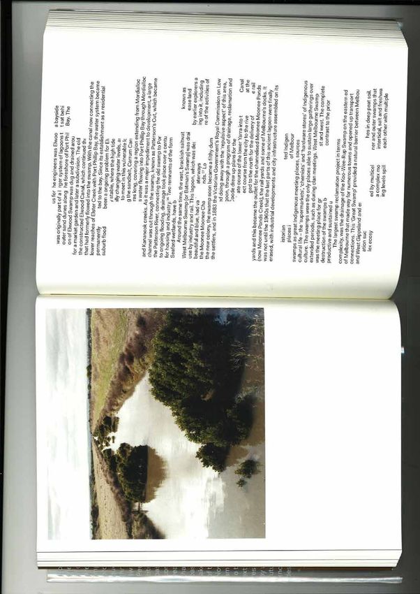
‘The Great Swamp’ then consisting of both swamps Fig. 3. Moodys Inlet, former Kooweerup Swamp in background, Koo Wee Rup.
‘grass in general’ also referring to reeds and sedges
(N. Scarlett, pers. comm.). in combination. Dalmore Swamp was joined with the
As with many swamps in Australia, Kuwirap Kooweerup Swamp, forming a western extension of ner swamp peat (Goudie 1942, Sargeant et al. 1996), The central Inlets area including Moodys Inlet
was said to be inhabited by a large black monstrous the outer swamp. The swamp was drained by five tid- suggesting the past existence of two inner swamps. is protected within the 83.7 ha The Inlets Waterway
amphibious creature with a harsh call known as the al creeks: Sawtell Creek at Tooradin and four creeks Reserve located in Koo Wee Rup and Dalmore and
bunyip. The Woi wurring called the creature Banib, at The Inlets. managed by Melbourne Water. Swamp remnants ex-
The central area has a layer of decomposed peat, The Inlets
hence the place name Bunyip, while the Bun wurrung tend onto the drainage reserve to the north as far as
called it Tooroodun, hence the name Tooradin (Data- up to 60 cm in thickness, approximately 75–85 cm the disused South Gippsland rail line, and also oc-
below the surface (Goudie 1942). The peat seam is The Inlets are a series of meandering tidal creeks open- cur on adjacent private land. The waterway reserve is
base of Aboriginal Placenames of Victoria 2002). ing onto the mangrove-fringed shore of northern West-
‘On the Western Port plains, there is a basin of valuable in market gardening due to the internal soil also contiguous with the North Western Port Nature
drainage it provides (Sargeant et al. 1996), the over- ern Port Bay. They were major outlets of the Koow- Conservation Reserve on the coast.
water—never dry, even in the hottest summers— eerup Swamp, previously draining the western outer
which is called Toor-roo-dun, because the Bun-yip lying black clay preventing it from being lost. Re- The Inlets formed within the Kooweerup Swamp
mains of club-sedge Bolboschoenus have been found swamp (the Dalmore Swamp). Old growth remnants and are not the lower reaches of streams that entered
lives in that water’ (Smyth 1878, Vol.1: 436), which of the swamp and its boundary with estuary vegetation
suggests Toor-roo-dun was also a name of the inner in the peat (S. Seymour pers. comm.), consistent with the swamp, as all feeder streams dissipated in the
Goudie (1942) who identified seeds of ‘Scirpus and occur at The Inlets (Yugovic 2008, Figs 3–6). swamp.
swamp. Reputed to devour human beings, Toor-roo- The number of creeks comprising The Inlets is
dun was said to inhabit the deep waters and the thick Lepidosperma’ in the peat (Bolboschoenus was pre- In plan the Inlets show a dendritic pattern of
viously Scirpus). between two and four depending on definition. There branching channels, each representing a self-
mud beneath the waters of the swamp, and to have a are two central inlets: the eastern Moodys Inlet and
head and neck like an emu’s (Smyth 1878). The centre of the Dalmore Swamp may have contained drainage unit which is long compared
once been an arm of the inner swamp until local geo- the western unnamed (and largely unreserved) inlet. with its breadth, and they present a remarkable
No bunyip story in Australia is recorded in de- Bird & Barson (1975) consider the Bunyip Drain
tail. The story may relate to seals, which occasion- logical uplift reduced the catchment size and stream similarity in form to the rill-marks that develop
flow of the western feeder streams, ending peat for- (east of the waterway reserve), known as Reeces In- on sloping surfaces of water-saturated sand or
ally visit freshwater rivers and swamps, as bunyips let before modification, to be one of the inlets. Hills
reported by early Europeans were apparently vagrant mation and leading to deposition of the overlying mud, such as may be seen on beaches at low tide.
Dalmore clay (Hills 1942). However, soil maps indi- (1942) considers Lyalls Inlet (west of the waterway (Hills 1942: 81).
seals, or even to extinct megafauna such as Dipro- reserve) to be another inlet.
todon (Flett 1999) although the swamp formed well cate the Dalmore peat was not connected with the in-
48 49180 J. YUGOVIC ECOLOGY OF THE KOOWEERUP SWAMP AND ASSOCIATED GRASSLANDS 181
Fig. 5. Edge of Kooweerup Swamp, Cardinia Creek drain in foreground, The Inlets.
The central creeks form a compound estuary as they of Prickly Spear-grass Austrostipa stipoides line the
share the same floodplain but enter the sea separately. winding channel of Moodys Inlet above the man-
The meanders in the creeks are apparently stable groves. Six native grassland communities occur on
as they have not changed significantly since The Inlets a range of saline to freshwater soils, making The In-
were first surveyed in 1866. This may be due to the lets outstanding in a state context. The area is also a
tidal nature of the channels—in a freshwater stream stronghold for the significant Swamp Skink Egernia
meanders migrate downstream over time due to uni- coventryi and Southern Brown Bandicoot Isoodon
directional current flow, whereas in a tidal stream the obesulus. Constructed levee banks support variable
flow reverses regularly so that meanders are more native and introduced vegetation (Yugovic 2008).
likely to be stable. However, mangrove shrubland The vegetation of The Inlets is highly complex
tends to occur on the sheltered downstream sides of due to variable water, salinity and disturbance re-
meanders in Moodys Inlet (Fig. 4), possibly due to gimes. Important factors determining vegetation pat-
strong currents during freshwater floods inhibiting terns are (a) topography in relation to inundation, the
the establishment of mangroves on the relatively ex- variation being created by natural features (islands,
posed sides of meanders. meandering channels and the dendritic drainage
The waterway reserve supports diverse, high pattern) overlaid by artificial features (drains, levee
quality native vegetation almost throughout. Old banks and borrow pits) and (b) the salinity gradient,
growth Kooweerup Swamp scrub occurs on inland which varies in time and space and generally exhib-
Fig. 4. Vegetation, The Inlets Waterway Reserve, Koo Wee Rup. sites and forms a sharp boundary with saline, treeless its a decrease in salinity with distance inland. Due to
estuary and saltmarsh vegetation. Estuary vegeta- the scale of mapping, the vegetation map (Fig. 4) is
tion at the boundary is dense sedgeland dominated necessarily a simplification of the intricate vegetation
by Coast Saw-sedge Gahnia trifida. Large tussocks pattern on the ground.
50 51182 J. YUGOVIC ECOLOGY OF THE KOOWEERUP SWAMP AND ASSOCIATED GRASSLANDS 183
Low ‘islands’ of terrestrial grassy vegetation, set Creek drains indicated in Roberts (1985) is unclear mapped by Smythe, the low two metre cliff con- agreeable’ (Blake 1977). The name is likely to be a
within the estuary vegetation, support distinctive plant but they are likely to be the pair of minor drains with sisting of exposed freshwater swamp peat and clay. reference to the open and productive grassy terrain
communities (Fig. 4). Some islands form a line 1500 parallel low levees within the central area, one on There was no single outlet, water issuing from the compared to dense swamp scrub. It is noted that
m in from the mangrove shoreline and may represent each side of Moodys Inlet (the western drain bisects swamp via ‘numerous rills of fresh water continually ‘monomeeth poath’ means ‘a grassy plain, a lawn’
the coastline during the mid Holocene marine maxi- the highest island). These drains and levees strongly running’ (Smythe 1843). ‘It is possible that floodwa- (Bunce in Smyth 1878, Vol. 2: 142).
mum. The highest site, which is split in two by a minor influence vegetation patterns (Fig. 4). ters spilling out in this way produced the crenulate With an extensive view to the ranges of the
drain, has a fringe of brackish grassland dominated by Today three large drains and their parallel levee shoreline, with waterfalls scouring out each cove’ Great Divide to the north, the open expanse would
Common Tussock-grass Poa labillardierei with a ha- banks pass north to south through the reserve: Car- (Bird & Barson 1975: 23). have indeed been beautiful, being composed mainly
lophytic component including Rounded Noon-flower dinia Creek drain on the west which crosses the Gum Scrub Creek drained the outer Kooweerup of blue-green Common Tussock-grass. As with the
Disphyma crassifolium (subject to occasional flooding highway under a bridge, and Deep Creek drain and a Swamp at Caldermeade and was vegetated by ‘Tea Clyde-Tooradin grassland (Cook and Yugovic 2003),
by brackish water). The higher central area supports closely parallel drain on the east. The latter two drains Tree Swamp’; it then entered Tobin Yallock Swamp in spring this plain would have been studded with
plains grassland with entirely glycophytic (freshwa- converge north of the highway (within the reserve) and dissipated. The scrub from the two swamps almost bright yellow Buttercup Ranunculus lappaceus,
ter) vegetation including Kangaroo Grass Themeda to become Deep Creek drain which also crosses the connected via a tenuous link where the first European shimmering purple and pink patches of Chocolate
triandra, Grass Triggerplant Stylidium graminifolium, highway under a bridge. Cardinia Creek drain is ap- ‘road’ was situated (Smythe 1843), almost certainly Lily Arthropodium strictum and Pale Vanilla-lily
Branching Bluebell Wahlenbergia multicaulis, Pale- proximately 20 m wide and is assumed to be the new following the Aboriginal trail between the swamps. Arthropodium milleflorum, and clusters of pure white
fruit Ballart Exocarpos strictus and six Acacia spe- drain referred to by Roberts as constructed in the sum- A valuable 1887 Lands Department plan of To- Smooth Rice-flower Pimelea glauca.
cies (never flooded). The fauna of the islands includes mer of 1938–39, along with the Deep Creek drain, bin Yallock Swamp, showing scrub along the coast ‘It was this natural grassland which made the Yal-
Swamp Skink, Southern Brown Bandicoot, Metallic following the ‘super flood’ of 1934. These drains have and a mosaic of scrub and grassland further inland, lock area, just south of the swamp, so attractive to the
Skink Niveoscincus metallicus, Blotched Blue-tongue high levee banks to confine overflows to the large area is in Key (1967: map 5). The grassland is described early squatters’ (Key 1967: 17). Smythe (1843) mapped
Lizard Tiliqua nigrolutea and Lowland Copperhead of natural vegetation between them. Toomuc Creek as ‘course pasture land very wet in winter’ and ‘very swamp scrub and Acacia woodland forming a mosaic
Austrelaps superbus. drain empties into the natural channel of Moodys In- good pasture land’. in the local area. The description of the relatively open
Aboriginal names for The Inlets are given on the let at the northern edge of the waterway reserve. The original boundary of the Tobin Yallock country between belts of ‘Tea Tree Swamp’ is ‘Rich
sketch map of the Western Port District by Assistant Ironically, the large Cardinia Creek and Deep Swamp is not delineated by this study. Further re- black soil wooded with Lightwood’ and ‘good grass’.
Protector William Thomas (1841) who named each of Creek drains have helped to protect the central area search and mapping is required to better define the The map of the open areas includes many clusters of
the ‘4 Muddy Rivers’ suggesting that The Inlets con- of The Inlets from destruction by agricultural devel- edges of the Tobin Yallock and Kooweerup Swamps dots that may represent trees, thus depicting a mosaic
sists of four streams. The western of the central pair of opment; however, there were unsuccessful attempts and the largely open area between them. of grassland and Acacia woodland.
inlets (unnamed today) is Lalln, while the eastern of to develop the area for agriculture, as evidenced by On its western side, The Great Swamp had an ad-
the central pair (Moodys Inlet) is Koonham (probably abandoned fences, a fallen windmill, and a derelict jacent ‘open grassy plain’ at Cardinia where Cardinia
Associated grasslands
pronounced Goonum with short ‘oo’). According to stock pen on one of the islands. Creek entered the swamp (Urquhart 1847). Another
Bun wurrung legend, The Inlets were formed by the The Inlets is no longer an obstacle to travel due ‘open grassy plain’ north of Tooradin about 5 by 2–3
wriggling of an immense snake (Gunson 1968). to constructed road bridges over drains that channel While being very familiar to the Yallock balug clan, km in size (Cook and Yugovic 2003) was described
In the 1840s, The Inlets was the greatest natural most of the fresh water through the area and out to explorer Samuel Wright was the first European to by Hovell:
hazard on the route between Melbourne and Port Al- the Bay. Since tides still penetrate the natural chan- see the extensive grassland or open woodland on the I came to another open space, quite clear of trees
bert due to the channels which were tidal and prone nels of the estuary, and fresh water is diverted into floodplain of Yallock Creek between the Kooweerup for several miles square, but so perfectly flat that
to freshwater flooding. ‘The noise of the overflow of drains except for Toomuc Creek which flows into and Tobin Yallock Swamps, describing it in 1826 as the water appears to have no possibility of drain-
the Swamp rushing through the tea tree at the inlets Moodys Inlet (via a drain), it is possible that the area follows: ing off, consequently after rain the ground must
was enough to frighten a faint heart.’ (Gunson 1968: is now generally more saline than originally; howev- in point of quality. . . equal to any he ever saw in be some time before it can absorb the whole, but
2). The first bridges were washed away but perma- er, the boundary of the Kooweerup Swamp (defined the Colony, it appeared like beautiful meadows at this time we could not get a drop to moisten
nent bridges were eventually built across The Inlets by Melaleuca) with the estuary at The Inlets has not in England, very thin of timber, grass excellent our lips, which would have been very acceptable
(Gunson 1968; Roberts 1985). changed significantly since the 1866 survey. (Wright in Gunson 1968: 18) from it being so very hot, and which we so much
Settler and swamp drainer William Lyall was a Soon after, explorer William Hovell described the required, having come upon a native path, which
member of the Acclimatization Society and introduced same area: led in the direction I wanted to go, I kept upon
Tobin Yallock Swamp one mile from the tent [mouth of Yallock Creek],
several fauna species to the area including Sambar it in hopes that it would lead to water (Hovell
Deer which occur there today. In 1873–4, he planted I came to a fine open level country, very thinly 1827: 90)
40 000 Sydney rock oysters within the channels of The The former extensive Tobin Yallock Swamp was covered with trees, soil of a good quality, and the Explorer William Blandowski crossed the grassy
Inlets but the enterprise was a disaster as the oysters south of the Yallock grasslands and was fed mainly grass long and fresh. . . the only objection to it is plains of Western Port in 1855.
were killed by freshwater floods (Gunson 1968). by the Lang Lang River. It consisted largely of Mela- that I think it lies too flat to be perfectly dry in Between Lisle’s station [Tooradin] and the inlets,
The Inlets contain the first drains constructed leuca scrub fanning out to form a 6 km length of the rainy seasons (Hovell 1827: 87-88) the land is swampy, and luxuriantly covered with
within the Kooweerup Swamp. Construction of the north-east coast of Western Port Bay. With no man- This grassy plain south of Yallock Creek seen excellent grass, well adapted for fattening cattle.
first drain, Cardinia Creek, which was 8 m wide at grove or salt marsh fringe and no beach, this shore- by Hovell is in Monomeith which is an Aboriginal . . Between Lisle’s and Cuthbert’s station [The
the surface, began in 1876 (Roberts 1985). The lo- line Melaleuca scrub was highly unusual in Victoria. word meaning ‘pleasant, good, pure’ (Massola 1968), Gurdies] the country consists of magnificent pas-
cation of the original Cardinia Creek and Toomuc The shore was probably cliffed and receding when ‘good and beautiful’ (Gunson 1968) or ‘pleasant,
52 53184 J. YUGOVIC ECOLOGY OF THE KOOWEERUP SWAMP AND ASSOCIATED GRASSLANDS 185
ture grounds, the horse having to walk through demanding Common Tussock-grass. Also present, soils occur on both sides of the surveyed boundary.
thick kangaroo grass, reaching up to the girths. usually on slightly drier sites, was Kangaroo Grass Since Melaleuca tends to occupy former grassland
(Blandowski 1855: 50-51). Themeda triandra, the dominant grass of dry basalt sites today, it is likely that Koories were burning back
The grassland strip between the inland paperbark grasslands in western Victoria. The grassland was the edge of the swamp for access and hunter gather-
scrub (Kooweerup Swamp) and the coastal saltmarsh rich in flora and fauna (Cook and Yugovic 2003) in- ing. All the early European explorers of Western Port
and mangrove scrub was less than 300 m wide in the cluding the Aboriginal staple Murnong (Yam Daisy) noted that large areas of land were burnt (Gaughwin
vicinity of The Inlets, and would have been a vital Microseris sp. which was probably common. 1981). Urquhart’s field book refers to frequent burn-
corridor in the middle of the Bun wurrung range. The Blackwood Acacia melanoxylon (then called ing reducing the Melaleuca on open plains ‘produc-
grassland is described as ‘good grass pasture land’ on Lightwood) and to a lesser extent Swamp Gum ing good grass’. William Thomas noted that since
the 1866 survey plan. Remnant vegetation includes were the major trees in this grassy environment the neighbouring Yowengarra clan was defunct their
grasslands associated with various salinity regimes. due to their resilience to flood, drought and fire. country had become scrubby because it was not be-
Relatively saline sites are dominated by Coast Tus- Blackwood’s suckering habit enables it to survive ing periodically burned (Clark 1990). ‘Many lay-
sock-grass Poa poiformis, brackish sites by Common fire. Some individuals would reach tree size and ers of burnt tea tree branches were found when the
Tussock-grass (Fig. 6) and non-saline sites by Com- avoid grass fires, forming a woodland. The area is swamp was drained’ (Roberts 1985: 6). As dry peat is
mon Tussock-grass or Kangaroo Grass. Native grass- just beyond the range of River Red-gum Eucalyptus flammable, accumulation of the massive peat deposit Fig. 7. Native grassland on the floodplain of Yallock
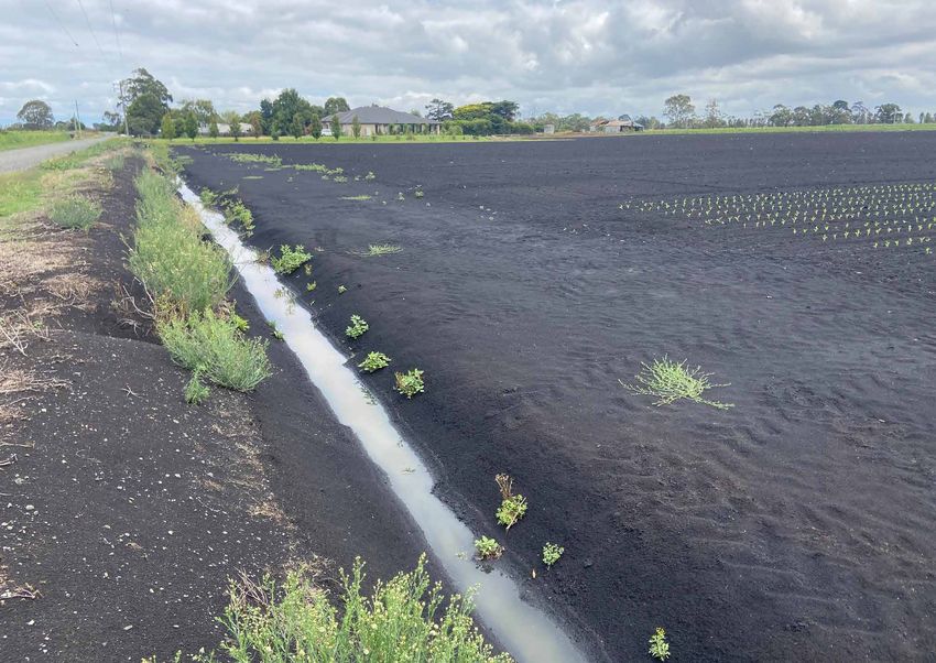
land on the ‘islands’ at The Inlets has been previously camaldulensis probably due to high rainfall. Acacia in the presence of the Aboriginal fire regime was pre- Creek, Monomeith Road, Monomeith.
discussed. woodland on flood plains, previously a distinctive sumably due to water in the inner swamp preventing
Grassland and Acacia woodland, essentially the part of the landscape, is now very rare or extinct major peat fires. Despite the once locally extensive occurrence of
same plant community, were locally extensive on as an ecosystem. However, Blackwood remains Melaleuca ericifolia reproduces by root-suck- floodplain grasslands in the region, recognition of
alluvial plains outside the wall of Melaleuca scrub widespread, mainly on road and rail reserves. ering and seedlings, enabling rapid spread under this distinctive ecosystem only occurred in the 1990s
that defined the edges of The Great Swamp and To- The outer swamp boundary has no clear relation- suitable conditions. The Koories were probably ad- with the listing of ‘Plains Grassland (South Gipps-
bin Yallock Swamp. The major grass was moisture- ship with soil type (Sargeant et al. 1996) as the same vantaged by a natural weakness or tolerance limit land)’ under the Flora and Fauna Guarantee Act
of Melaleuca: while it was flood tolerant it was not (SAC 1994), reflecting early modification and loss of
tolerant of the high fire frequency on the swamp mar- the grasslands before recording. These grasslands are
gin associated with drier soils and more flammable more depleted than the familiar but also endangered
vegetation. Melaleuca can regenerate after fire but basalt grasslands of western Victoria.
may be greatly reduced in cover, so the position of The extremely rare plains grassland may be pre-
the swamp boundary is likely to have been a long- dicted to occur on alluvial ‘black soil’ outside the
term response to repeated burning. margins of former swamps on the Gippsland plain.
Drainage patterns indicate the floodplain grass- The eastern side of The Great Swamp may have
lands and woodlands occurred on slightly higher and had little or no grassland, as in the north-east area
therefore less flooded land than the swamp. It follows where foothills of the ranges formed an edge with
that the soils were more prone to dry out and crack the swamp (Garfield to Bunyip). Here Melaleuca
in summer but it is unlikely that soil factors alone evidently extended to the break of slope. However,
would have controlled Melaleuca. A combination of the rail survey map with this evidence was compiled
soil and fire factors may have operated to confine the after cessation of the Aboriginal fire regime, so Mela-
scrub. Both the inner and outer swamp boundaries leuca may have spread onto grassland.
may have been relatively stable over time, or dy- By enabling targeted survey, this detailed
namic and responsive to change in factors such as knowledge of the swamp boundary has been useful in
rainfall, evaporation, flooding and fire. locating and recognising several significant remnants
Fire may have been particularly important to the of grassland such as the Clyde-Tooradin grassland
Bun wurrung for access purposes. Aboriginal burn- along the South Gippsland rail line (Cook and Yugov-
ing is likely to have maintained the 18 km open space ic 2003) and the Yallock grassland seen by Samuel
corridor between Tooradin and Lang Lang and the Wright 185 years ago (Fig. 7). Similarly, extremely
effective separation of the Kooweerup and Tobin rare remnants of outer swamp scrub have been found,
Yallock Swamps. The Yallock balug clan were most including significant examples at The Inlets.
likely managing their grassy open landscape by regu- Native grassland at The Inlets discovered by this
lar burning, without which the land would have be- study is now being managed by Melbourne Water.
come dense and effectively uninhabitable scrub. In The main objectives for vegetation management are
doing so they maximised both food production and to limit Melaleuca, which is overabundant due to
biodiversity. lack of fire, and to control introduced plants. Foxes
Fig. 6. Native grassland on an ‘island’ within the estuary, The Inlets.
54 55186 J. YUGOVIC ECOLOGY OF THE KOOWEERUP SWAMP AND ASSOCIATED GRASSLANDS 187
are also being controlled to assist the population of CONCLUSION scientifically based management for biodiversity Cook, d. & yugoviC, J., 2003. Clyde-Tooradin grass-
Southern Brown Bandicoot. conservation. land rediscovered. The Victorian Naturalist
The Kooweerup Swamp was a unique ecosystem with 120: 140–146.
distinct zonation formed by inner and outer swamps. dAtABAse of ABoriginAl PlACenAmes of viCtoriA,
ECOLOGICAL VEGETATION CLASSES ACKNOWLEDGEMENTS
The inner swamp was a permanently inundated reed 2002. Victorian Aboriginal Corporation for
and rush swamp on deep peat with localised emer- Languages (compiled by ID Clark and T
Native vegetation in Victoria is classified into Thanks to Sally Mitchell, Katherine Crowder, Bretan Heydon).
gent sand ridges. It consisted of a descending series
ecological vegetation classes (EVCs) by the Clifford, Robert Fitzgerald and Paul Young (Biosis DPI, 2004. Fisheries Victoria Commercial Fish Pro-
of lake-like cells or lagoons separated by dense belts
Department of Sustainability and Environment Research) for mapping, Tim Allen for Fig. 3, and duction Information Bulletin 2004. Primary
of vegetation, resulting in multiple internal water lev-
(DSE). Numerous EVCs occurred within the Damien Cook, Doug Frood, Ian Sargeant, Neville Industries Research Victoria, Department of
els rather than the single water level of most swamps.
Kooweerup Swamp area. The mapping of the Scarlett, Jill Anderson, Gary Vines, Ian Smales, Chris Primary Industries, Victoria.
The fringing outer swamp was subject to frequent
original (1750) vegetation on the DSE Biodiversity Bloink, Peter Menkhorst, Ian Miles, Rob Gell, Scott eAst, L.R., 1935. Swamp reclamation in Victoria.
flooding and supported dense Melaleuca giving an
Interactive Map shows only one extensive EVC, Seymour and Cathy Dowling for comments. Journal of the Institute of Engineers, Aus-
impression that the scrub occurred throughout. Ad-
Swamp Scrub, throughout almost the entire area of tralia 7: 77–91.
jacent grasslands and grassy woodlands were occa-
the swamp deposit including areas now known to flett, J., 1999. A History of Bunyips: Australia’s
sionally flooded and were locally extensive beyond REFERENCES
have been extensive reedswamp (inner swamp) and Great Mystery Water Beasts. Free Spirit
the generally sharp swamp boundary.
grassy open plains (surrounding areas). Depicted Press, Tyalgum, NSW.
It appears that the inner swamp boundary was BAll, d. & BlAke, S., 2001. Seagrass mapping of
occurrences of Swampy Riparian Woodland running foot, H.B., 1855. Country allotments in the Parish
primarily flood controlled while the outer swamp Western Port. Marine and Freshwater Re-
through the entire swamp are also incorrect as all of Yallock County of Mornington. Surveyor-
boundary was primarily fire controlled on the plain, sources Institute Report No. 29. Marine and
feeder streams dissipated within the swamp. General’s Office, Melbourne.
and topographically controlled by hills to the east. Freshwater Resources Institute, Queenscliff.
The following EVCs are likely to have been gAugHWin, D., 1981. Sites of archaeological signifi-
Aboriginal burning maintained the adjacent grass- Bird, e.C.f. & BArson, M.M., 1975. Shoreline
present: cance in the Western Port catchment. Envi-
lands and woodlands but had little or no influence on changes in Westernport Bay. Proceedings of
Inner swamp: the core of the swamp where permanent water pre- the Royal Society of Victoria 87:15–28. ronmental Studies Series 367, Ministry for
Tall Marsh widespread, extensive (reed vented major peat fires. BlAke, L.J., 1977. Place Names of Victoria. Rigby, Conservation, Victoria.
swamp) Despite the major environmental change, some Melbourne. gell, R.A., 1974. Shore development in the Lang
Aquatic Herbland lakes within reedswamp of the wetland flora and fauna of the original swamp BlAndoWski, W., 1855. Report No. III to the Survey- Lang area. BSc (Hons) thesis, Department of
Aquatic Sedgeland lakes within reedswamp live in, visit or pass through the area today, the many or-General of an excursion from King’s Sta- Geography, The University of Melbourne.
Outer swamp: drains and pastures providing modified habitat. tion to Bass River, Phillip and French Islands. goudie, A.G., 1942. A survey of soils and land uti-
Swamp Scrub widespread, extensive Swamp Paperbark and Common Reed are conspicu- Transactions of the Philosophical Institute of lization in the parishes of Koo-wee-rup and
Swampy Woodland sandy ridges ous along many drains. In addition, some flora and Victoria 1: 50–67. Koo-wee-rup East. Proceedings of the Royal
Swampy Riparian levees lining creeks fauna from the forest catchment of the Bunyip River, BrAzenor, C.W., 1932. A re-examination of Gymno- Society of Victoria 54: 93–130.
Woodland such as Silver Wattle Acacia dealbata, have colo- belideus leadbeateri McCoy. Australian Zo- gott, B., 1993. Use of Victorian plants by Koories.
Estuarine Scrub estuaries draining the swamp nised the banks of the Bunyip Main Drain. ologist 7: 106–109. In Flora of Victoria Volume 1: Introduction,
This study shows how careful interpretation of CAllAnAn, M., 1859. Country Lots, Parish of Sher- D.B. Foreman & N.G. Walsh, eds, Inkata
High ground within swamp: small remnants, in combination with examination of Press, Melbourne.
wood, County of Mornington. Public Lands
Grassy Woodland Rythdale Ridge, Cardinia archival records, can further our knowledge of highly gunson, N.. 1968. The Good Country: Cranbourne
Office, Melbourne, now held by State Li-
Ridge, Tynong Island fragmented vegetation types such as native grass- Shire. Cheshire, Melbourne.
brary of Victoria.
Surrounding plains: lands. It also demonstrates that existing vegetation CAllAnAn, M., 1866. Country Lands, Parishes HAm, T., 1849. A map of Australia Felix. Thomas
Grassy Woodland locally extensive on plains on roadsides and in drains may be misleading as to of Yallock & Lang Lang, County of Ham, Melbourne.
Plains Grassland locally extensive on open pre-European vegetation patterns. Mornington. Hills, E.S., 1942. The physiography of the Koo-wee-
plains, and The Inlets Further historical research and field investigation CAnnon, M. (ed.), 1983. Historical Records of Victo- rup Swamp. Proceedings of the Royal Society
Plains Grassy drainage lines and depres- would resolve these wetland and grassland ecosystems ria Foundation Series Vol 2B Aborigines and of Victoria 54: 79–91.
Wetland sions on open plains more clearly, this analysis forming a basis for further Protectors 1838–1839. Victorian Govern- Hills, E.S., 1975. Physiography of Victoria: An In-
Estuarine Reedbed estuaries draining the swamp study. An understanding of historical and existing ment Printing Office, Melbourne. troduction to Geomorphology. Whitcombe &
Estuarine Wetland estuaries draining the swamp ecosystems and landscapes provides the basis for CAtAni, G., 1901. Letter to The Inspector General. Tombs, Australia.
Brackish Sedgeland estuaries draining the swamp informed land management. Small areas of scrub and Public Record Office Victoria (VPRS Hovell, W., 1827. Remarks on the Voyage to West-
Brackish Grassland estuaries draining the swamp grassland remain, with significant examples at The 12650). ern Port. Journal of William Hovell, State
Estuarine Flats estuaries draining the swamp Inlets Waterway Reserve currently being managed by ClArk, I.D., 1990. Aboriginal languages and clans: Library of Victoria.
Grassland Melbourne Water. An historical atlas of western and central key, L.M., 1967. Historical geography of the Koow-
Coastal Saltmarsh estuaries draining the swamp All remnants of the Kooweerup Swamp and its Victoria, 1800–1900. Monash Publications eerup district. MA thesis, School of Geogra-
Mangrove Shrubland estuaries draining the swamp associated grasslands require detailed mapping and in Geography 37, Monash University. phy, The University of Melbourne.
56 57188 J. YUGOVIC
mAssolA, A.S., 1968. Aboriginal Place Names of smytHe, G.D., 1843. Survey of the eastern coast of
South-east Australia and their Meanings. Western Port. Land Victoria.
Lansdowne, Melbourne. sPenCer-Jones, d., mArsden, m.A.H., BArton, C.m.
miles, I.W., 1976. The morphology of northern & CArrillo-riverA, J.J., 1975. Geology of
Westernport Bay. MSc thesis, Department of the Westernport Sunkland. Proceedings of
Geography, The University of Melbourne. the Royal Society of Victoria 87: 43–68.
nye, E.R., 2004. Distributional ecology of the Mag- urquHArt, W.S., 1847. Continuation of the survey of
pie Goose (Anseranas semipalmata) and the the Toomuc Creek to the Great Swamp. Cen-
Wandering Whistling Duck (Dendrocygna tral Plan Office, Land Victoria.
arcuata) in Australia. PhD thesis, The Uni- WAllBrink, P.J., HAnCoCk, g.J., olley, J.m., HugH-
versity of Sydney. es, A., Prosser, i.P., Hunt, d., rooney, g.,
o’CAllAgHAn, T., 1918. Names of Victorian Railway ColemAn, r. & stevenson, J., 2003. The
Stations. Government Printer, Melbourne. Western Port sediment study. CSIRO Con-
roBerts, D. 1985. From Swampland to Farmland: sultancy report.
A History of the Koo-Wee-Rup Flood Pro- Wesson, S., 2001. Aboriginal flora and fauna names
tection District. Rural Water Commission of of Victoria: As extracted from early survey-
Victoria. ors’ reports. Victorian Aboriginal Corpora-
rosengren, N. 1984. Sites of geological and geomor- tion for Languages, Melbourne.
phological significance in the Westernport yugoviC, J. & mitCHell, S., 2004. Preliminary vege-
Bay catchment. Environmental Studies Series tation mapping of the Koo-Wee-Rup Swamp
401, Department of Conservation, Forests & and adjacent grasslands. Report to Cardinia
Lands, Victoria. Shire Council, Biosis Research Pty Ltd, Vic-
SAC 1994. Flora and Fauna Guarantee – Scientific toria.
Advisory Committee. Final recommendation yugoviC, J. & mitCHell, S., 2005. Vegetation map-
on a nomination for listing: Plains Grassland ping of the Koo-Wee-Rup Swamp and ad-
(South Gippsland) Community. jacent grasslands. Report to Cardinia Shire
sArgeAnt, i., imHof, m., lourey, r., mArtin, J., nink, Council, Biosis Research Pty Ltd, Victoria.
r., de PlAter, k., rAmPAnt, P., tHomPson, s. yugoviC, J. & mitCHell, S., 2006. Ecological review
& zilm, J., 1996. Major agricultural soils of of the Koo-Wee-Rup Swamp and associated
the Cranbourne and Koo-Wee-Rup vegetable grasslands. The Victorian Naturalist 123:
growing region. Department of Natural Re- 323–334.
sources & Environment, Victoria. yugoviC, J., 2008. Flora and fauna of The Inlets, Koo
smytH, R.B., 1878. The Aborigines of Victoria: with Wee Rup, Victoria. Report to Melbourne Wa-
notes relating to the habits of the natives ter. Biosis Research Pty Ltd, Victoria.
of other parts of Australia and Tasmania.
2 Volumes, Victorian Government Printer,
Melbourne.
58 59You can also read