Winter Storm Saturday Night-Sunday - Decision Support Briefing #2 As of 9:00 AM Friday, Jan. 18, 2019 - Borough of Stone Harbor
←
→
Page content transcription
If your browser does not render page correctly, please read the page content below
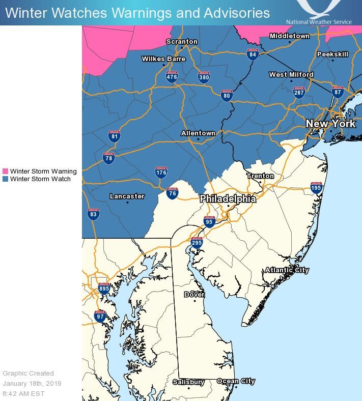
Winter Storm Saturday Night-Sunday
Decision Support Briefing #2
As of 9:00 AM
Friday, Jan. 18, 2019
What Has Changed?
The threat of significant icing has
migrated further south toward the I-95
corridor
Western Montgomery and Upper Bucks
Counties have been added to the
Winter Storm Watch
Weather Forecast Office
Presentation Created 1/18/2019
Philadelphia/Mount Holly @NWS_MountHolly NWSMountHolly
9:27 AM
Main Points
      Hazard                             Impacts                        Location                         Timing
                                                                                                  Snow will overspread these
                                A mix of snow, sleet, and freezing
                                                                     Most significant impacts    areas Saturday afternoon and
Snow and                         rain will create very hazardous
                                                                      will be along and north    evening and quickly increase
                                travel conditions. Roadways will
Wintry Mix of                                                        of I-78, but ice and snow    in intensity. Snow may mix
                                be snow and ice covered. Power
Snow, Sleet and                                                          accumulations are        with sleet, freezing rain, or
                                  outages are possible due to a
                                                                      possible further south      rain by overnight Saturday
Freezing Rain                   combination of freezing rain and
                                                                       into the I-95 corridor.   night. Precipitation will wrap
                                               wind.
                                                                                                      up Sunday evening.
                                  An initial burst of snow, sleet,                                  Urban and small stream
                                freezing rain will change over to                                flooding is possible Saturday
Heavy Rain                                                           Along and southeast of
                                  heavy rain. This will bring the                                  night and Sunday morning
and Flooding                                                            the I-95 corridor.
                                potential for both urban flooding                                 with river flooding possible
                                        and river flooding.                                        later Sunday into Monday.
                                  A rapid temperature drop will                                   Sunday late morning NW of
                                  cause any slush or standing                                    the I-95 corridor and Sunday
Flash Freeze                     water to freeze solid, leading to
                                                                     All of our forecast area.
                                                                                                 afternoon from that corridor
                                       very icy conditions.                                                    SE.
                                Gale force wind gusts will create
                                                                                                    Winds increase Sunday
                                   hazardous conditions for           Coastal areas of New
                                                                                                  afternoon and evening and
Wind/Marine                     mariners. Strong winds near the       Jersey, Delaware, and
                                                                                                    peak Sunday night and
                                  coast could cause localized          our coastal waters.
                                                                                                           Monday.
                                         power outages.

Coastal                             Minor coastal flooding is        Atlantic coast, Delaware
                                                                                                  Sunday morning high tide.
Flooding                                   possible.                 Bay, tidal Delaware River
      Weather Forecast Office
                                                                                                       Presentation Created 1/18/2019
   Philadelphia/Mount Holly                     @NWS_MountHolly        NWSMountHolly
                                                                                                                  9:27 AM
Summary of Greatest Impacts
                              Snow and mix: Along and north of I-78
                                None          Limited     Elevated      Significant     Extreme

                              Heavy Rain: Along and SE of I-95
                                None           Limited     Elevated      Significant    Extreme

                              Flash Freeze: NJ, DE, NE MD, SE PA
                                None          Limited     Elevated      Significant     Extreme

                              Wind/marine: coastal waters, adjacent shores
                                None           Limited     Elevated      Significant    Extreme

                               Coastal Flooding: Atlantic, DE Bay & River
                                 None           Limited     Elevated      Significant    Extreme

   Weather Forecast Office
                                                                                                   Presentation Created 1/18/2019
Philadelphia/Mount Holly                @NWS_MountHolly        NWSMountHolly
                                                                                                              9:27 AM
Forecast Snow Accumulations
Uncertainty in Snowfall
Forecast:
Snow and ice totals will be
dependent on the timing
and duration of the
precipitation type.
Near and along the I-95
corridor, a small shift in the
storm track could result in
big differences in
precipitation type and
amount.
If sleet and freezing rain
occurs for a longer period,
snow accumulations will
decrease but overall
impacts will remain
significant.
Weather Forecast Office
Presentation Created 1/18/2019
Philadelphia/Mount Holly @NWS_MountHolly NWSMountHolly
9:27 AM
Forecast Ice Accumulations
Uncertainty in Ice
Forecast:
Snow and ice totals will be
dependent on the timing
and duration of the
precipitation type
Near and along the I-95
corridor, a small shift in the
storm track could result in
big differences in
precipitation type and
amount
If sleet and freezing rain
occurs for a longer period,
ice accumulations will
increase.
Weather Forecast Office
Presentation Created 1/18/2019
Philadelphia/Mount Holly @NWS_MountHolly NWSMountHolly
9:27 AM
Probabilistic Snowfall Forecast
                     Low End Potential                                     High End Potential
  9 in 10 (90%) Chance of Higher Snowfall                     1 in 10 (10%) Chance of Higher Snowfall
            Than Depicted Below                                         Than Depicted Below

   Weather Forecast Office
                                                                                       Presentation Created 1/18/2019
Philadelphia/Mount Holly                 @NWS_MountHolly   NWSMountHolly
                                                                                                  9:27 AM
Coastal Flooding
Sunday morning high tide
This graphic shows the
expected degree of flooding
Middlesex
Mercer on the oceanfront, bays,
Bucks Monmouth
and estuaries along the
highlighted areas.
Ocean
Delaware Burlington
New Castle
Cecil
Salem
Atlantic
Cumberland
Kent
Kent
No Flooding
Caroline
Talbot Spotty Minor Flooding
Sussex Minor Flooding
Moderate Flooding
Major Flooding
Weather Forecast Office
Presentation Created 1/18/2019
Philadelphia/Mount Holly @NWS_MountHolly NWSMountHolly
9:27 AM
Event Summary
A significant winter storm will impact the mid-Atlantic this weekend with a wide
variety of precipitation types and impacts.
For northern NJ and northeast PA, a period of heavy snowfall is likely beginning
late Saturday with a change to sleet/ice likely overnight. Very hazardous travel
conditions are expected in these areas and freezing rain and wind could lead to
power outages.
Heavy rainfall in areas south of the rain/snow transition zone could lead to both
urban flooding Saturday night and Sunday and river flooding later Sunday into
Monday. Flooding potential is largely dependent on how much precipitation falls
as rain as opposed to ice and snow.
Sunday late morning and afternoon, a rapid temperature drop will lead to a hard
freeze of any areas of slush and standing water, even for areas that received
little to no snowfall. This will lead to very icy conditions Sunday evening and
overnight. Bitterly cold air will make clearing snow and ice very difficult.
Minor coastal flooding is possible with the Sunday morning high tide, mostly
along the Atlantic Coast, Delaware Bay, and the tidal Delaware River.
Strong winds behind the storm late Sunday through Monday will lead to
hazardous conditions over the waters for mariners and localized power outages
on adjacent shores.
Weather Forecast Office
Presentation Created 1/18/2019
Philadelphia/Mount Holly @NWS_MountHolly NWSMountHolly
9:27 AM
Contact and Next Briefing Information

                                                       Next Briefing
                                                      When: by 5 PM on
                                                    Friday, January 18, 2019

                                                Briefing Webpage:
                                    www.weather.gov/media/phi/current_briefing.pdf

                                    Web:                                              Facebook:
                              www.weather.gov/phi                                    NWSMountHolly

                                Phone (public):                                        Twitter:
                                (609) 261-6600                                      @NWS_MountHolly

                             Disclaimer: The information contained in this briefing is time-
                             sensitive; do not use after the next briefing package is issued.

   Weather Forecast Office
                                                                                                     Presentation Created 1/18/2019
Philadelphia/Mount Holly                          @NWS_MountHolly   NWSMountHolly
                                                                                                                9:27 AM
You can also read