A snapshot of water quality from sampling freshwater invertebrates in Purau stream, Lyttelton Harbour/Whakaraupō - LEAP Research Report
←
→
Page content transcription
If your browser does not render page correctly, please read the page content below
LEAP Research Report
No. 55

A snapshot of water quality
from sampling freshwater
invertebrates in Purau stream,
Lyttelton Harbour/Whakaraupō
Report for Environment Canterbury
Kate Marshall

February 2021
A snapshot of water quality from
  sampling freshwater invertebrates in
    Purau stream, Lyttelton Harbour/
              Whakaraupō

            Report for Environment Canterbury

                                             Kate Marshall

February Land Environment and People Research Report

                                                No. 55
                                                 2021

                                        1172-0859 (Print)
                                        1172-0891 (PDF)
                                   978-0-86476-460-7 (Print
                                  978-0-86476-461-4 (PDF)

               Lincoln University, Canterbury, New Zealand
Cover photo: Purau Bay, Lyttelton Harbour/Whakaraupō. Source: Jo, 2009, https://flic.kr/p/6gCYFy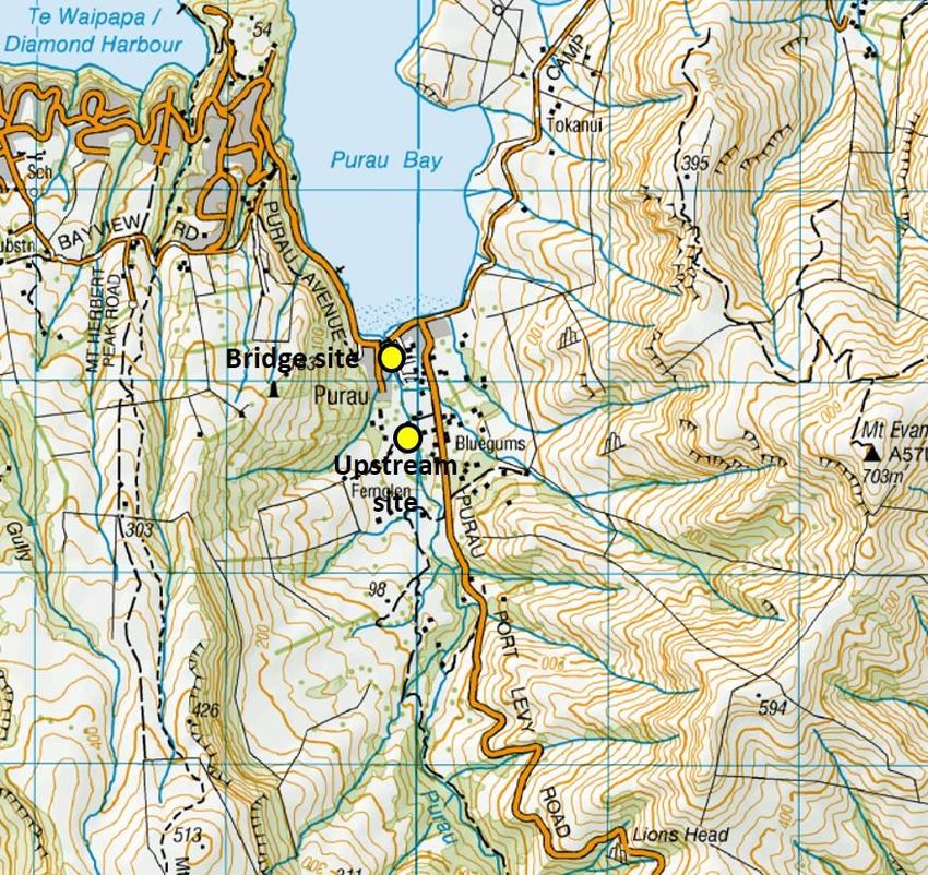
Contents
List of Figures ……………………………………………………………………………...2
List of Tables………………. ...................................................................................... 2
Summary………. ....................................................................................................... 3
   1.1. Whaka-ora Healthy Harbour Programme ..................................................... 4
   1.2. Why aquatic Invertebrates? .......................................................................... 4
   1.3. Aim of research.............................................................................................. 5
Chapter 2. Catchment Attributes ............................................................................ 6
   2.1. Climate and Rainfall ...................................................................................... 6
   2.2. Geology and Soils ......................................................................................... 6
   2.3. Vegetation ...................................................................................................... 7
Chapter 3. Overview of Historical Human Influences ........................................... 9
   3.1 Māori Settlement ............................................................................................. 9
   3.2. European Settlement ................................................................................... 10
Chapter 4. Sampling Methods ............................................................................... 11
   4.1. Study Area .................................................................................................... 11
   4.2. Materials and Methods ................................................................................ 13
   4.3. Statistical Analysis ...................................................................................... 13
   4.4 Limitations..................................................................................................... 14
Chapter 5. Results .................................................................................................. 15
Chapter 6. Discussion............................................................................................ 19
   Conclusion .......................................................................................................... 20
   Acknowledgments .............................................................................................. 20
Appendix……………. .............................................................................................. 21
References…………................................................................................................ 23

                                                                                                                         1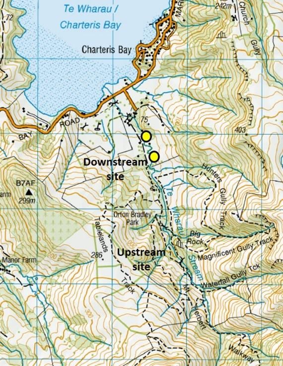
List of Figures
Figure 1: Location map of study sites in Purau and Te Wharau catchments         5
Figure 2: Surface rock type illustrating the volcanic origins, and soil types   6
Figure 3: Aerial imagery of Purau catchment vegetation 1970-1974 and 2018
imagery                                                                         8
Figure 4: Richard Oliver. The Māori Settlement, Purau Bay, Port Cooper          9
Figure 5: The destruction of old growth native forests on the Peninsula
happened rapidly                                                                10
Figure 6: Water quality sampling sites in Purau (Left); and Te Wharau Stream    12
Figure 7: Current vegetation patterns in Purau and Te Wharau catchments         12

Figure 8: Purau Stream Site 1 (Bridge) looking upstream. Purau Stream Site 2
looking downstream. Te Wharau Stream Site 3 looking upstream. Te Wharau
Stream Site 4 looking downstream                                                14
Figure 9: Invertebrate orders identified in the samples from Purau Stream, January
2021                                                                             15
Figure 10: Macroinvertebrate Community index (MCI) values for Purau and Te
Wharau Streams                                                                  15
Figure 11: Macroinvertebrate Community index (MCI) values for Purau Stream at
the Purau-Port Levy road bridge site from 2011-2021                           16
Figure 12: Substrate index mean for all sites                                   17
Figure 13: Qualitative assessment of mean canopy cover (%) for all sites        17

                             List of Tables
Table 1: Assessment criteria for habitat parameters: Bank Stability; Sediment
Deposition; and Embeddedness/Siltation.                                         21
Table 2: MCI scores from samples taken in Purau Stream, Purau Bay and Te
Wharau Stream, Orton Bradley Park                                               22
Table 3: Interpretation of MCI values                                           22
Table 4: Species list from Purau sites 1 and 2                                  22

                                                                                    2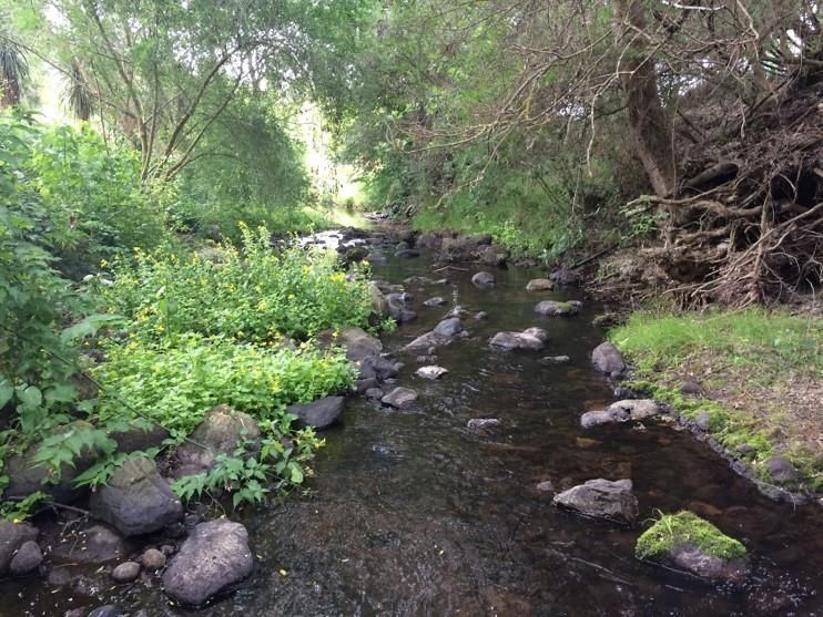
Summary
Whaka-Ora Healthy Harbour is a partnership between Te Hapū o Ngāti Wheke, Te
Rūnanga o Ngāi Tahu, the Lyttelton Port Company, Environment Canterbury and
Christchurch City Council1. The partnership is working to restore the ecological and
cultural health of Lyttelton Harbour/Whakaraupō in conjunction with resident groups.
The restorative focus includes: increasing indigenous biodiversity; protecting and
restoring mahinga kai values; providing a safe place for recreation; and protecting
the harbour for future generations. Currently, issues relating to the health of the
harbour have been identified, such as sedimentation, erosion, high nutrient levels,
and bacterial contaminants, which cumulatively impact on indigenous biodiversity
and coastal water quality.
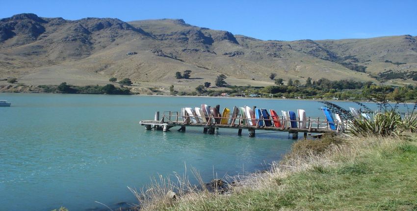
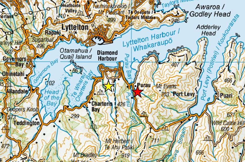
Purau Bay is one of the large bays located on the southern side of Lyttelton Harbour/
Whakaraupō, located also within the wider Banks Peninsula/Te Pātaka o Rākaihautū
area. Purau Bay has a permanently flowing stream that winds its way through a
variety of land uses, including indigenous vegetation, pastoral farmland, and
residential properties before discharging into the harbour. This study takes a
snapshot of the environmental quality of Purau Stream by examining the diversity of
aquatic invertebrates as an indicator of the stream health at two sites along the
stream. The results from the macroinvertebrate community index (MCI) were
compared to Te Wharau catchment in nearby Orton Bradley Park, where
contemporaneous data were also collected from two locations within the stream.
The condition of both streams was assessed as being in overall good health,
although the MCI was lower at the Purau bridge site compared to the upstream site
and the Te Wharau stream sites. Previous water quality sampling by Environment
Canterbury at the bridge indicates that although the current condition is classified as
good, the long-term trend is may be declining water quality.
These results contribute to informing progress towards the partnership’s long-term
plan for these streams, which is “to enhance the riparian margins and water quality
to a state where sensitive species are present”: The current condition of both
streams is contextualised within past changes to the catchment, through the
presentation of a brief overview of historical events.
1
https://www.healthyharbour.org.nz/
3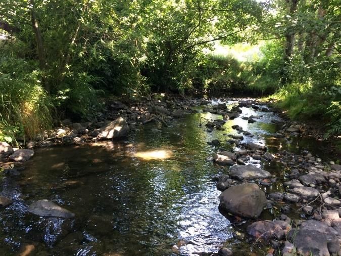
Chapter 1. Introduction

1.1. Whaka-ora Healthy Harbour Programme
The Whaka-ora Healthy Harbour Catchment Management Plan was developed
during development of the Lyttelton Port Recovery Plan. The communities around
the harbour wanted agencies and the community to help improve the health of the
harbour. This resulted in a partnership between five agencies, Te Hapū o Ngāti
Wheke, Te Rūnanga o Ngāi Tahu, the Lyttelton Port Company, Environment
Canterbury and Christchurch City Council.
Launched in 2018, the Whaka-ora Healthy Harbour plan is supported by the five
partners to help the community achieve the action points. The main aim of the plan
is to “restore the ecological and cultural health of Whakaraupō/Lyttelton Harbour as
mahinga kai” (Whaka-ora, n.d). This includes increasing biodiversity, safeguarding
mahinga kai values, providing a safe place for recreation and protecting the harbour
for future generations.
Streams are one of the focal points in the Whakaraupō/Lyttelton Harbour Catchment
Management Plan, as there are five permanently flowing streams discharging into it.
These streams are in excellent condition in the upper reaches but start to deteriorate
as they get closer to the harbour. To help improve the water quality the plan aims to
focus on fencing off the stream to stock and the planting of the riparian zone.
Whaka-ora Healthy Harbour have identified Purau Bay as an area of significant
recreation, ecological and mahinga kai value. Issues relating to the health of the
harbour, such as sedimentation, erosion, water pollution and decreasing indigenous
biodiversity have also been identified as problems within the catchment. Purau
Stream has a number of landowners who are working together to help restore the
catchment (K, Banwell, personal communication, November 2020).
Whaka-ora Healthy Harbour and Lincoln University jointly funded a summer research
scholarship to investigate the environmental quality of Purau Stream in late
2020/early 2021. Results from sampling for aquatic invertebrates are reported here
along with a discussion about the stream health. The results are compared with Te
Wharau stream, which is a separate catchment to the south (Figure 1).

1.2. Why aquatic Invertebrates?
There are many abiotic and biotic factors that influence the composition of aquatic
invertebrate communities in streams and rivers (Wright-Stow & Winterbourn, 2003).
These factors can include pH, temperature, substrate composition and species
interactions. As environmental factors change over time, this can affect the species
inhabiting the streams. Sensitive species, such as Ephemeroptera (mayfly),
Trichoptera (caddisfly) and Plecoptera (stonefly), can be replaced by more pollution
tolerant species such as Oligochaeta (worm) and Littorinimorpha (snail), as water
quality deteriorates (Wright-Stow & Winterbourn, 2003).

                                                                                       4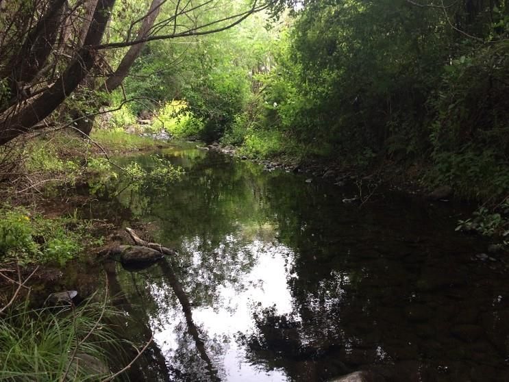
The Macroinvertebrate Community Index (MCI) can be used to indicate the health of
freshwater ecosystems in New Zealand2, as the invertebrate species present in a
waterway affect the outcome of the MCI calculation. Species such as mayfly,
caddisfly and stonefly are more sensitive to changes in their environment and
contribute a higher score towards to the MCI. Whereas, species such as worms or
snails are more tolerant of polluted waterways and can lower the MCI (Landcare
Research, n.d). An MCI score higher than 120 indicates excellent stream health,
whereas a score of 80 or below indicates poor stream health (Gray, 2013).
Aquatic invertebrates are a common group of organisms to monitor for waterway
health, as they are relatively easy to measure over time using standard procedures,
their sampling being relatively non-destructive of the environment, inexpensive and
biologically relevant (Cairns, McCormick and Niederlehner, 1993).

1.3. Aim of research
This study seeks to investigate the environmental quality of Purau Stream with MCI
scores at a point in time. The sampling is augmented with an assessment of
instream habitats and substrata, and overhead canopy cover. The results are
compared to Te Wharau Stream catchment in Orton Bradley Park (Figure 1). An
overview of historical changes to the Purau catchment is also presented to assist in
contextualising current conditions.

    Figure 1: Location map of study sites in Purau (red star) and Te Wharau (yellow star) catchments.

2
    https://www.lawa.org.nz/learn/factsheets/benthic-macroinvertebrates/

                                                                                                        5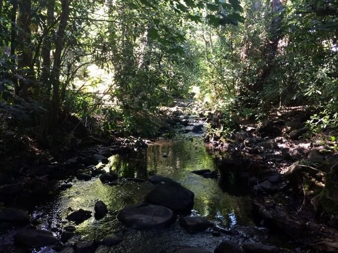
Chapter 2. Catchment Attributes
2.1. Climate and Rainfall
Purau Bay is one of many large bays located on Banks Peninsula/Te Pātaka o
Rākaihautu on the south shore of Lyttelton Harbour/Whakaraupō, surrounded by
Mount Herbert (920 m), the highest Banks Peninsula peak, and Mount Evans (Figure
1). Rainfall recorded at the closest weather station at Coopers Knob is around 730
mm per year (Environment Canterbury, n.d). Winter brings snow above 600 m,
especially after southerly storms, snow may last from a few days to a few weeks on
the high peaks. Summer droughts are often worsened by strong, dry nor ‘west winds
(Wilson & Department of Conservation, 1992).

2.2. Geology and Soils
Banks Peninsula was primarily formed by two large volcanoes, Lyttelton and Akaroa
which are both now extinct. These extinct volcanoes form the two main harbours in
Canterbury, Lyttelton and Akaroa harbours, after part of the caldera walls were
breached allowing the sea water to fill up and form the harbours (Wilson, 2009).
This forms the basis of the peninsula’s extensive parent material type (Figure 2). Soil
fertility on the peninsula is mostly medium to high fertility and quite free-draining
(Wilson, 2009) (Figure 2).

   Figure 2: Surface rock type illustrating the volcanic origins (left), and soil types (right). Source:
   Manaaki Whenua Landcare Research Our Environment. https://ourenvironment.scinfo.org.nz/

                                                                                                           6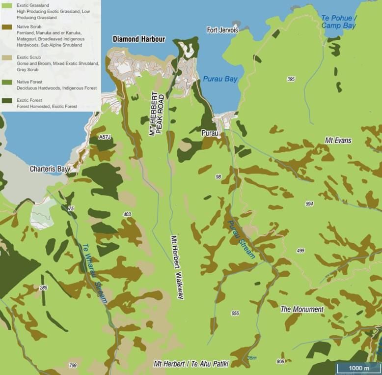
The Peninsula was first known as Banks Island, named by James Cook after Joseph
Banks, a botanist on board the Endeavour (Olgivie, 2007). Originally, the peninsula
was an island, and was gradually connected c. 7,000 years ago to the ongoing
formation of the Canterbury Plains (Beaumont, Carter & Wilson, 2014). Sand and
gravel outwash from the eroding Southern Alps was carried down by large braided
rivers, which spread away from the mountains and formed the plains over millennia.3

2.3. Vegetation
Before human settlement, the area would have been almost entirely forested with
emergent podocarp forest. Abundant tree species included: matai (Prumnopitys
taxifolia), kahikatea (Dacrycarpus dacrydioides), rimu (Dacrydium cupressinum),
miro (Prumnopitys ferruginea), broadleaf (Griselinia littoralis), mahoe (Melicytus
ramiflorus) and pigeonwood (Hedycarya arborea). Sub-alpine and alpine species
such as snow tussock (Chionochloa rigida), fescue tussock (Festuca novae-
zelandiae), Dracophyllum spp. and mountain flax (Phormium colensoi) were found
on the high bluffs and peaks (Wilson & Department of Conservation, 1992).
Occupying this forested area was an abundance of New Zealand native birds,
including kiwi (Apteryx spp.), kaka (Nestor meridionalis), tui (Prosthemadera
novaeseelandiae), kereru (Hemiphaga novaeseelandiae), moa (Dinornithiformes)
and saddleback (Philesturnus carunculatus) (Beaumont, Carter & Wilson, 2014).
Many of these species are now at risk of extinction or became extinct due to habitat
loss, hunting, and introduced mammalian predators.
Around one-third of the forest was removed in the Mount Herbert area when
Polynesian settlers came to the area. Much of the remaining forest was removed by
European settlers by logging, burning and conversion to pasture for farming. Some
very small fragments of the original forest remain today (Wilson & Department of
Conservation, 1992; Peart & Woodhouse 2021).
Aerial imagery shows that scrub and tree cover is greater in recent times than the
early 1970s (Figure 3). This due to the retirement of some marginal areas, riparian
areas being fenced off, restoration plantings of indigenous species, and radiata pine
(Pinus radiata) production forestry. The Purau catchment is now used primarily for
grazing sheep and cattle, pine forestry, with a small settlement.

3
 For more information, readers are directed to a recent landscape restoration and planning study
“Restoring Te Pātaka o Rākaihautū/Bans Peninsula by the Environmental Defence Society (Peart &
Woodhouse 2021) funded by Environment Canterbury. www.eds.org.nz

                                                                                                   7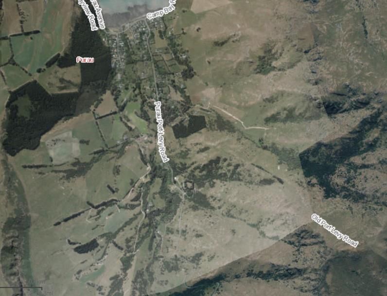
Figure 3: (Top) Aerial imagery of Purau catchment vegetation 1970-1974. (Bottom) 2018 imagery
retrieved 19 February 2021 https://apps.canterburymaps.govt.nz/CanterburyHistoricAerialImagery/

                                                                                                  8
Chapter 3. Overview of Historical
Human Influences
3.1 Māori Settlement
Purau Bay is thought to be one of the oldest sites on Te Pātaka o Rākaihautu/Banks
Peninsula for Māori settlement. Ovens containing moa bones, stone adzes and
necklaces have been found at excavation sites near the beach (Olgivie, 1970).
Artefacts excavated from the beach include greenstone and stone adzes identified
from the Ngāi Tahu era (Olgivie, 1970). Te Pātaka o Rākaihautu means the
storehouse of Rākaihautu as the forests contained an abundance of food (Mahaanui
Iwi Management Plan 2013). For a history of tangata whenua relationships with the
whenua, ngahere, awa, and moana of the area as shared publicly, readers are
directed to the Waitangi Tribunal report on the Ngāi Tahu Treaty Claim (1991).
From 1836, whaler ships began to visit the peninsula regularly, Māori traded with the
whalers for items such as tools, clothing, food and medicine (Christchurch City
Council, n.d). Some Māori men were also able to gain employment on the whale
ships (Olgivie, 2007). Along with the employment, whalers also bought alcohol,
tobacco, muskets and European diseases (Olgivie, 2007). The Māori population on
the peninsula in 1849 was recorded at around 300, and in 1857 the Purau population
was recorded at 12 (Christchurch City Council, n.d).
Figure 4: Richard Oliver. The Māori Settlement, Purau Bay, Port Cooper. 1850. Collection of Christchurch Art
Gallery Te Puna o Waiwhetū; purchased with assistance from the Olive Stirrat Bequest, 1983. Source:
https://christchurchartgallery.org.nz/collection/83-49/richard-aldworth-oliver/the-maori-settlement-
purau-bay-port-cooper
93.2. European Settlement
The Greenwood brothers, James, Joseph and Edward, were the first European
settlers at Purau Bay in 1843. The brothers planned to squat on the land and James
travelled to Australia to organise the purchase of cattle to ship to the Peninsula (The
Press, 1945). As they ‘had no legal rights to buy land in the South Island’ (Ogilive,
1970 p23), this caused problems with the local Māori population and the
government. After many discussions, the Greenwoods agreed to pay the local Māori
a yearly rent of six blankets and printed calico (Ogilive, 1970).
After a robbery of the Greenwood brothers, Edward decided to return home to
England. The Purau station was sold in 1847 for £1710, which included the stock, to
the Rhodes brothers (The Press, 1945). Joseph Greenwood was lost at sea in 1848
after the whaleboat he was travelling on to Motunau, washed up in pieces near
Kaikōura (Nelson Evening Mail, 1932). James travelled to Sydney to purchase stock
for a farm the brothers wanted to set up in Motunau, he never returned, assumed
murdered as he was carrying money (Ogilive, 1970). George Greenwood arrived in
1864 to settle the family matters (Ogilive, 1970).
Figure 5: (Left) Purau Bay and surrounding hills with all native forest felled, 1939. Retrieved: 23 Feb:
https://paperspast.natlib.govt.nz/newspapers/CHP19390504.2.129.5?items_per_page=10&query=pur
au&snippet=true&type=ILLUSTRATION. (Right) The destruction of old growth native forests on the
Peninsula happened rapidly, as described here in 1900. Retrieved 23 Feb
https://paperspast.natlib.govt.nz/newspapers/AMBPA19000710.2.7?items_per_page=50&query=pura
u+forest&snippet=true
10The Rhodes brothers set up a station in Akaroa in 1843 and then started to purchase
other land, including Purau, Kaituna and Ahuriri. In 1850, when Lyttelton was being
settled, The Rhodes brothers were able to supply the workers with dairy products,
vegetables and meat (Ogilive, 1970). Some of the brothers moved south to set up a
station near Timaru, while Robert Rhodes remained in Purau to run the peninsula
stations (The Press, 1937). From 1866-1874, the station was managed by various
people while Robert was in Christchurch managing the family’s business matters. In
1874 Robert returned to England after his health declined to seek medical treatment
and in the same year Henry Gardiner purchased the Purau Station for 20,000
pounds (Ogilive, 1970; The Star, 1909). Much of the native bush was felled during
this time and sown with cocksfoot, with the development of the station (Figure 5).
The Gardiner family worked this area for the next 50 years (Ogilive, 1970).
Chapter 4. Sampling Methods
4.1. Study Area
This study took place in Purau Bay and Orton Bradley Park (Figure 1). Sampling
was conducted in the middle of January 2021 over two days. The temperature
during this time was 13-14 °C with between 0.5 mm and 1.0 mm of precipitation in
the 2 days leading up to the sampling, recorded at nearby Cooper’s Knob.
The streams selected for this study were Purau stream (-43.639154 S, 172.750120
E) located in Purau Bay, and Te Wharau Stream (-43.654954 S, 172.705582 E),
located in Orton Bradley Park, Charteris Bay (Figure 6). Both catchments have
pastoral agriculture, primarily grazing for sheep and cattle in the upper and middle
areas of the catchment (Figure 7). The lower catchment areas differ with Purau
predominantly urban, immediately surrounding the stream. Orton Bradley is a
privately owned park which has public facilities and walking tracks in the lower
catchment area. Both catchments have areas of exotic tree species, including areas
of radiata pine plantations, willows along streamsides, and regenerating native shrub
and tree species (Figure 7).
11Figure 6: Water quality sampling sites in Purau (Left); and Te Wharau Stream (Right), January 2021.
Figure 7: Current vegetation patterns in Purau and Te Wharau catchments. Source: Manaaki
Whenua Landcare Research’s Our Environment.
124.2. Materials and Methods
Within each of the four sampling sites, there were three subsampling points along a
50m reach. Sub-sample sites were selected within the 50 m reach. All sites were
located under mature tree canopy, either exotic or native species (Figure 9).
Invertebrates were collected using a kick sample with a D shaped net (NIWA, 2020).
The net was placed at the selected site, and an area of streambed 80 cm upstream
of the net and the width of the net (30 cm) was disturbed. This was done twice at
each sampling point along each transect. Samples were sorted as they were taken.
The invertebrates collected from Purau Bay were preserved in 70 % ethanol, with
some easy to identify taxa released, such as dobsonfly and smooth cased caddisfly.
Invertebrates collected from Orton Bradley were sorted with photographs taken and
released back to the stream as per the ranger’s instructions.
An estimate of the canopy cover was taken by sight and was taken by the same
person throughout to ensure consistency. Substrate composition was estimated,
categories used were: boulders larger than 25 cm, large cobbles 12-25 cm, small
cobbles 6-12 cm, gravels under 6 cm, sand, silt and woody debris (NIWA, 2020).
A habitat assessment was conducted following the methods used by Environment
Canterbury (obtained from A, Barnden, Environment Canterbury) at all four stream
areas. This assessment scored features of the habitat in four categories: optimal,
suboptimal, marginal and poor. The habitat parameters assessed were “Bank
Stability”, “Embeddedness/Siltation”, and “Sediment Deposition” (Appendix 1).
4.3. Statistical Analysis
Data were recorded, analysed and graphed in Microsoft Excel. Sampling sites were
grouped by location and an average was created to show the average for MCI and
canopy cover which gave us four representative sites.
The MCI score was calculated using the equation: (Stark, 1985):
The taxa recorded in each sample were given a score between one and ten. For
example, a pollution tolerant snail is given the score of three and a sensitive species
such as a stonefly, is given the score of ten. These scores are summed together to
give the site score, this score was then divided by the number of scoring taxa in the
sample and multiplied by 20.
The substrate index was calculated as follows (McMurtie & Greenwood, 2008):
13Figure 8: (Top left) Purau Stream Site 1 (Bridge) looking upstream. (Top right) Purau Stream Site 2
looking downstream. (Bottom left) Te Wharau Stream Site 3 looking upstream. (Top right) Te Wharau
Stream Site 4 looking downstream.
4.4 Limitations
Limitations for this study included not being able to take invertebrates back to the
laboratory from Orton Bradley Park for identification. This information was only found
out on the day of sampling even after contacting the park’s ranger via email
previously. Accessibility of Purau stream was a limitation for this study as most of the
land surrounding the stream is privately owned. The sites used for the study were
publicly accessible but if more time were allowed, more sites would be beneficial but
would involve gaining permission and a site visit up the whole of the stream to
determine sampling sites.
14Chapter 5. Results
A total of six orders were identified from the collected invertebrates from the two
streams. These orders are: Trichoptera (caddisfly), Megaloptera (dobsonfly),
Ephemeroptera (mayfly), Diptera (fly), Littorinimorpha (snail) and Oligochaeta
(worm). Figure 9 displays the different orders found in Purau Stream at the two
locations that were sampled. Site 1 (Bridge) had high numbers of pollution-tolerant
species than Site 2 (Upstream). The two Orton Bradley sites were qualitatively
similar to Purau Site 2. The MCI scores reflected this pattern, with Purau Site 1
having the lowest MCI, although this was still in the B category (rated as ‘Good’).
The other three sites were in the ‘Excellent’ category (Figure 10).
Figure 9: Invertebrate orders identified in the samples from Purau Stream, January 2021.
Figure 10: Macroinvertebrate Community index (MCI) values for Purau and Te Wharau Streams.
15The MCI results for Purau Site 1 are generally consistent with previous annual
sampling at the road bridge, albeit a little lower than most of the previous years
(Figure 11). Annual data analysis for Purau Stream also includes median taxonomic
richness from the last 5 years and median Ephemeroptera (mayfly), Plecoptera
(stonefly) and Trichoptera (caddisfly) (%EPT) from the last 5 years. Taxonomic
richness for this site is currently recorded at 26 and %EPT is 40.7 (LAWA, n.d).
Although the taxonomic richness is on the higher side, the percentage of sensitive
species used to calculate the %EPT is on the low side. The %EPT is the percentage
of mayfly, stonefly and caddisfly present in a sample; a low percentage can indicate
poor stream health as the rest of the sample is made up of pollution tolerant species.
Taxonomic richness at Purau site 1 was recorded as 8 and %EPT calculated as
37.5. Purau site 2 taxonomic richness also recorded as 8 and %EPT calculated as
62.5.
Figure 11: Macroinvertebrate Community index (MCI) values for Purau Stream at the Puraru-Port
Levy road bridge site from 2011-2021. Environment Canterbury data from www.lawa.org.nz The MCI
calculated from this study is depicted as a yellow circle.
The mean of the substrate composition at each of the four sites is shown in Figure
13. The higher the number, the higher the percentage of large cobbles or boulders
at that site. Orton Bradley site 1 had the highest mean at 5.8, with the lowest at
Purau site 2 with 5.2. This is unlikely to be a meaningful difference in an ecological
sense, given the similarity in the habitats depicted in Figure 9. Moreover, the MCI
scores do not show a similar pattern between sites. In other words, Purau Site 1 did
not have the highest or lowest mean score that would suggest the small differences
in the index scores were significant in ecological habitat terms.
16The results from the qualitative assessment of canopy cover (Figure 13) also did not
suggest differences in assessed cover were an explanatory factor in the MCI
patterns observed. Purau Site 1 and Te Wharau Site 4 (Orton Bradley Site 2) had
similar cover at >60%, yet the MCI scores differed markedly (Figure 10). The MCI
scores of Purau Site 2 and Te Wharau Site 3 (Orton Bradley Site 1) were similar to
Te Wharau Site 4, yet canopy cover for Purau Site 2 was much lower at 40% (Figure
13). The site photos show all sites had shading from intact tree cover (Figure 8).
Figure 12: Substrate index mean for all sites.
Figure 13: Qualitative assessment of mean canopy cover (%) for all sites .
17Erosion of the stream banks was recorded in the habitat assessment with the Te
Wharau (Orton Bradley) sites scoring higher than the Purau sites. Both left and right
banks were scored separately at each sampling site. Orton Bradley site 1 had a
suboptimal score for both banks – that is moderately stable with small areas of
erosion. The streambanks at Orton Bradley site 2 were assessed as suboptimal and
marginal (moderately unstable with 30-60% of the bank area with small areas of
erosion). The situation at Purau site 1 was marginal for both banks; and assessed as
marginal and poor at site two; where poor is unstable, with many eroded areas and
erosional scars over most of the banks.
The visibility of sediment in the streams differed between the sites, with Purau site 1
in the urban area carrying the highest amount of streambed sediment. In the habitat
assessment for sediment deposition, Orton Bradley site 1 and Purau site 2 scored
suboptimal (slight deposits observed), Orton Bradley site 2 scored marginal
(moderate amounts of silt deposition) and Purau site 1 scored poor (heavy deposits
of fine material).
The embeddedness of siltation around boulders, cobbles, and gravel also differed
between the sites. Orton Bradley site 1 and Purau site 2 were assessed as
suboptimal (fine sediment surrounding 30-50% of the coarser material). Orton
Bradley site 2 scored marginal (>50-75% surrounding); and Purau site 1 scored poor
(the coarser material was surrounded by fine sediment)
18Chapter 6. Discussion
Results from the macroinvertebrate community index (MCI) suggested that
environmental conditions at the road bridge site at Purau was different to the other
sites. The other Purau and the two Te Wharau stream sites more closely resembled
each other in MCI, with more abundant pollution sensitive species such as smooth
cased caddisfly, helix caddisfly, mayfly, dobsonfly, cranefly and bark caddisfly. In
contrast, Purau bridge (Site 1) had a greater abundance of pollution-tolerant species;
such as polychaete worms, snails, and non-biting midges. Snails and non-biting
midge are found in degraded and polluted waterways elsewhere (NIWA, 2020).
Notwithstanding the lower MCI score at Purau Site 1, it is still assessed as ‘Good’ in
the accepted MCI classification system (www.lawa.org.nz). However, it would be
prudent to undertake sampling of other water quality analytes, such as bacteria and
nutrients, to determine the likely cause(s) of the relative deterioration. This may then
lead to a targeted investigation to identify and manage the source of the stressors.
This is because it is unlikely that subtle differences in assessed canopy cover and
substrata are plausible explanatory factors. All sites had canopy cover with large
mature exotic trees such as willow, with native trees/shrubs and smaller exotic trees
in the understorey. Aquatic invertebrates primarily prefer lower instream
temperatures, which are influenced by canopy shading that keep a cooler
temperature more consistently than if the stream was in full sun (Collier, 1995).
The high water quality in the other sites sampled is reflected in the presence of
mayflies and caddisflies. If environmental conditions were to deteriorate, these
species will start to decline and be replaced with more snails, worms and midges.
Other organisms such as dobsonflies and fish feed on mayflies and caddisflies; so a
decline or loss of these prey species may influence the resilience of the food web.
Substrate composition is one of the most important factors for invertebrate
composition, as the substrate provides habitat and food sources in the stream
environment (Bourassa and Morin, 1995). The substrate index mean was very
similar for all sites. Purau sites one and two were 5.5 and 5.2. With the Orton
Bradley sites one and two at 5.8 and 5.3. Purau site 1 had a visibly noticeable
amount of sediment settled into the gaps of cobbles compared to the other sites, but
overall the substrate composition was similar at all sites, with a mixture of boulders,
large cobbles, small cobbles, gravels and silt (Figure 10).
There are a number of environmental factors which could cause a change in
substrate composition and thereby affect stream health, such as a loss of riparian
vegetation, or catchment land use activities. For example, clearfell harvesting of
radiata pine has been shown to deposit large volumes of fine sediment in waterways
from soils high in clay content (O’Loughlin, 1979), such as those found throughout in
the catchment. Sediment entering waterways is a natural process, however high
levels of sediment from human activities can be damaging to freshwater ecosystems
(NIWA, n.d). When excessive amounts of sediment enter a waterway, it starts to
settle in the gaps between rocks in the substrate. These gaps are important habitats
19for aquatic invertebrates and can decrease the abundance of sensitive species. This
is because sediment fills up the gaps between cobbles, preventing invertebrates
seeking shelter between and under the cobbles. A literature review completed by
Davies-Colley et al. (2015) of many studies from around the world, highlighted that
invertebrate abundance decreases as sediment increases. Wood et al. (2005)
documented that sensitive species were absent from sediment over 10 mm but some
were able to survive in less than this. The areas of erosion observed upstream in
Purau Stream could be a contributing factor to the higher sediment load downstream
when the flow of the stream is higher or in flood
Conclusion
Overall, the health of Purau Stream and Te Wharau stream are in good health as
indicated by their MCI values, however it is clear that Purau stream has degraded in
quality as it reaches the urban area. This could be due to impacts from the
surrounding land uses. It is reassuring to see that the two streams are in relatively
good condition, however work needs to continue to restore the waterways to assure
that the ecological health is maintained, rather than degrades. Actions such as
riparian plantings, fencing waterways, limiting fertiliser and pesticide use where
possible can all help with nutrient run-off and erosion control to contribute to better
stream health. Harvesting of the pine plantations will also need to be managed with
care to prevent run-off into the streams and out into Lyttelton Harbour/Whakaraupō.
Acknowledgments
This summer research project was made possible thanks to funding from Lincoln
University and Whaka-ora Healthy Harbour.
I would like to thank my supervisor, Dr Steve Urlich, for all the help and support
throughout this project. From initial project design, to support and advice for the
report through to the final stages of editing the drafts. Steve has been a great
supervisor throughout the process.
Thank you to Wendy Fox for assisting with field work.
20Appendix
Table 1: Assessment criteria for habitat parameters: Bank Stability; Sediment
Deposition; and Embeddedness/Siltation.
21Table 2: MCI scores from samples taken in Purau Stream, Purau Bay and Te
Wharau Stream, Orton Bradley Park, January 2021.
Table 3: Interpretation of MCI values (from Gray, 2013)
Table 4: Species list from Purau sites 1 and 2
22References
Beaumont, L., Carter, M., & Wilson, J. (2014). Banks Peninsula: contextual historical
overview and thematic framework. Christchurch City Council.
https://www.ccc.govt.nz/assets/Documents/Culture-Community/Heritage/14-
974633-Banks-Peninsula-Contextual-Historical-Overview-and-the matic-
Framework-FINAL-.pmd.PDF
Bourassa, N., & Morin, A. (1995). Relationships between size structure of
invertebrate assemblages and trophy and substrate composition in streams.
Journal of the North American Benthological Soiciety, 14(3), 393-403.
https://doi.org/10.2307/1467205
Cairns, J., McCormick, P., & Niederlehner, B. (1993). A proposed framework for
developing indicators of ecosystem health. Hydrobiologia, 263, 1-44.
https://doi.org/10.1007/BF00006084
Collier, K. (1995). Environmental factors affecting the taxonomic composition of
aquatic macroinvertebrate communities in lowland waterways of Northland,
New Zealand. New Zealand Journal of Marine and Freshwater Research,
29(4), 9:4, 453-465. https://doi.org/10.1080/00288330.1995.9516679
Christchurch City Council. (n.d). Banks Peninsula District Plan.
https://www.ccc.govt.nz/assets/Documents/The-Council/Plans-Strategies-
Policies-Bylaws/Plans/district-plan/banks-peninsula/Chapter05-
bpdplistofpdfs.pdf
Davies-Colley, R., Hicks, M., Hughes, A., Clapcott, C., Kelly, D., & Wagenhoff, A.
(2015). Fine sediment effects on freshwaters, and the relationship of
environmental state to sediment load. NIWA.
mfe.govt.nz/sites/default/files/media/Fresh%20water/fine-sediment-effects-on-
freshwaters.pdf
Environment Canterbury. (n.d). Rainfall for Coopers Knob.
https://www.ecan.govt.nz/data/rainfall-data/sitedetails/326611
Gray, D. (2013). Freshwater ecology: quantitative macroinvertebrate sampling in
soft-bottomed streams. Department of Conservation.
https://www.doc.govt.nz/globalassets/documents/science-and-
technical/inventory-monitoring/im-toolbox-freshwater-ecology/im-toolbox-
freshwater-ecology-soft-bottomed-stream-quantitative-macroinvertebrate-
sampling.pdf
Jolly, D., & Ngā Papatipu Rūnanga Working Group. (2013). Mahaanui Iwi
Management Plan. https://mahaanuikurataiao.co.nz/wp-
content/uploads/2019/08/Full-Plan.pdf
23Landcare Research. (n.d). Indicator Species.
https://www.landcareresearch.co.nz/tools-and-
resources/identification/freshwater-invertebrates-guide/indicator-species/
Land Air Water Aotearoa. (n.d). Purau Stream at Purau Port Levy Road.
https://www.lawa.org.nz/explore-data/canterbury-region/river-quality/purau-
stream/purau-stream-at-purau-port-levy-road/
Nelson Evening Mail. (1932, 30 August). Obituary Mr G. D. Greenwood.
https://paperspast.natlib.govt.nz/newspapers/NEM19320830.2.7
NIWA. (n.d). Sediment. https://niwa.co.nz/our-
science/freshwater/tools/kaitiaki_tools/impacts/sediment#:~:text=Sediment%2
0in%20a%20stream%20is,ecosystems%20and%20kill%20mahinga%20kai.&t
ext=Sediments%20are%20a%20natural%20part,geology%20of%20the%20su
rrounding%20area
NIWA. (2020). Stream health monitoring and assesment kit.
https://niwa.co.nz/sites/niwa.co.nz/files/SHMAK_Chapter%204_Field%20man
ual_low%20res.pdf
McMurtie, S., & Greenwood, M. (2008). Long-Term Monitoring of Aquatic
Invertebrates in Christchurch’s Waterways: Otukaikino and Styx River
Catchments 2008. Christchurch City Council.
https://ccc.govt.nz/assets/Documents/Environment/Water/Monitoring-
Reports/5-Yearly-Otukaikino-and-Styx-River-Invertebrates-2008-PDF-3.15-
MB.PDF
Olgivie, E. (1970). Purau. The Caxton Press
Olgivie, G. (2007). Banks Peninsula: cradle of Canterbury. Philips & King Publishers
O’Loughlin, CL. (1979). Near-shore seawater quality study, Marlborough Sounds.
NZ Forest Service, unpublished Forest Research Institute Report (available
from library@scionresearch.com), and reported in 1980 in the New Zealand
Journal of Ecology Vol 3. Resumes.
http://newzealandecology.org/nzje/1495.pdf
Peart, R., & Woodhouse, C. (2021). Restoring Te Pātaka o Rākaihautū/Banks
Peninsula. Environmental Defence Society. Auckland
Press. (1937, 24 April). Early Canterbury.
https://paperspast.natlib.govt.nz/newspapers/CHP19370424.2.106
Press. (1945, 21 April). Banks Peninsula Stations
https://paperspast.natlib.govt.nz/newspapers/CHP19450421.2.33
Stark, J. D. (1985). A macroinvertebrate community index of water quality for stony
steams. Water and soil miscellaneous publication, no 87
24Star. (1909, 5 February). Obituary Mr Henry Dent Gardiner.
https://paperspast.natlib.govt.nz/newspapers/TS19090205.2.61
Waitangi Tribunal Report. (1991). The Ngai Tahu Report.
https://forms.justice.govt.nz/search/Documents/WT/wt_DOC_68476209/Ngai
%20Tahu%20Report%201991%20V1W.pdf
Whaka-ora Healthy Harbour. (n.d). Home. https://www.healthyharbour.org.nz/
Wilson, H., & Department of Conservation. (1992). Banks ecological region.
Department of Conservation.
Wilson, H. (2009). Natural history of Banks Peninsula. Canterbury University Press
Wood, P., Toone, J., Greenwood, M., & Armitage, P. (2005). The response of four
lotic macroinvertebrate taxa to burial by sediments. Archiv für Hydrobiologie,
163(2), 145-162. https://doi.org/10.1127/0003-9136/2005/0163-0145
Wright‐Stow, A. E., & Winterbourn, M. J. (2003). How well do New Zealand's stream‐
monitoring indicators, the macroinvertebrate community index and its
quantitative variant, correspond? New Zealand Journal of Marine and
Freshwater Research, 37(2), 461-470.
https://doi.org/10.1080/00288330.2003.9517180
25You can also read