Durrow Development Forum Durrow Community Plan 2019-2023
←
→
Page content transcription
If your browser does not render page correctly, please read the page content below
Durrow Development Forum

      Durrow Community Plan 2019-2023

   This Community Plan is funded by Laois Partnership and Laois Local
Community Development Committee under the LEADER Rural Development
                              Programme

                                  1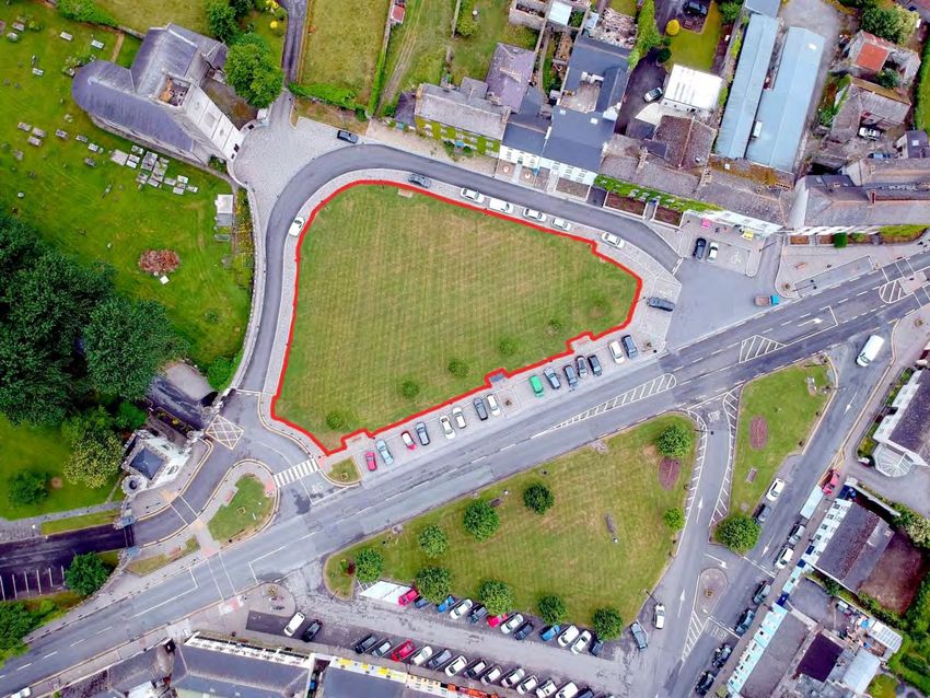
Table of Contents

  1.1 Background to Community and Participatory Planning ............................................... 5

     1.2 Durrow Development Forum ......................................................................................... 5

     1.3 Consultation Process ...................................................................................................... 7

     1.4 Summary findings of Resource Audit ............................................................................. 8

     1.5 Strengths, Weaknesses, Threats, Opportunities ............................................................ 9

     1.6 Location .......................................................................................................................... 9

     1.7 Population Profile ......................................................................................................... 14

     1.8 Plan Context ................................................................................................................. 16

Chapter 2 Social, Community and Economic Development ...................................... 19

  2.1 Community and Social Infrastructure ....................................................................... 19

     2.1.1 Redevelopment of Methodist Church and Civil Defence property on Patrick Street 19

     2.1.2 Rationale for Investment in Community Facilities .................................................... 21

     2.1.3 Policy Context ............................................................................................................ 22

     2.1.4 Durrow Community Centre: Key Funding Challenges & Needs Analysis .................. 22

     Figure 2.5 Elevation of Proposed Community Centre ........................................................ 24

     2.1.6 Multi-Use Games Area (MUGA) and pitch for Soccer Club ....................................... 24

     2.1.7 Play Areas for Children .............................................................................................. 26

  2.2 Economic Development and Employment ................................................................ 27

     2.2.1 Tourism...................................................................................................................... 27

     2.2.2 Building on the Successful Wedding Business .......................................................... 28

     2.2.3 Buildings for Businesses ............................................................................................ 30

  2.3 Movement and Transport ........................................................................................ 31

     2.3.1 Improvements for Pedestrians .................................................................................. 31

     2.3.2 Facilitating Cycling in Durrow .................................................................................... 34

     2.3.3 Parking in Durrow...................................................................................................... 36

     2.3.4 Traffic Calming........................................................................................................... 39

                                                                    2
Chapter 3 Culture and Heritage ............................................................................... 45

   3.1 Arts and Culture ...................................................................................................... 45

      3.1.1 Introduction............................................................................................................... 45

      3.1.2 The Scarecrow Festival .............................................................................................. 47

      3.1.3 The Development of Interpretative Centres & Museums ........................................ 47

   3.2 Built Heritage .......................................................................................................... 48

      3.2.1 Built Heritage Introduction ....................................................................................... 48

      3.2.2 Future Enhancements to Built Heritage .................................................................... 49

Chapter 4 Housing, Key Development Sites and Environmental and Public Realm

Improvements ........................................................................................................ 53

   4.1 Housing ................................................................................................................... 53

   4.2 Public Realm............................................................................................................ 57

      4.2.1 Seating ....................................................................................................................... 57

   4.3 Environmental Projects ............................................................................................ 58

      4.3.1 Natura 2000 sites ...................................................................................................... 58

      4.3.2 Waterways ................................................................................................................ 61

      4.3.3 Walkways .................................................................................................................. 62

      4.3.4 Cycle Trails ................................................................................................................. 63

      4.3.5 Biodiversity ................................................................................................................ 65

   4.4 Sustainability Strategy ............................................................................................. 67

      4.4.1 Energy Efficient Grants .............................................................................................. 67

      4.4.2 Waste Management .................................................................................................. 67

      4.4.3 Water Management .................................................................................................. 68

Chapter 5: Project Action Implementation Plan ....................................................... 70

   5.1 Subcommittee Structure .......................................................................................... 70

   5.2        Focus Areas & Objectives: ................................................................................. 70

      5.2.1 Community Participation & Community Infrastructure [Community Projects] ....... 70

                                                                     3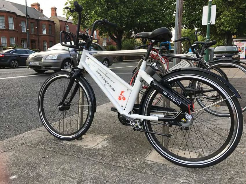
5.2.2 Community Culture, Expression & Identity [Cultural Heritage Projects] .................. 71

       5.2.3 Enterprise in the Community [Community Enterprise Projects] .............................. 71

       5.2.4 Primary Focus Area 1: Community Participation & Community Infrastructure....... 72

       5.2.5 Primary Focus Area 2: Community Culture, Expression & Identity........................... 73

       5.2.6 Primary Focus Area 3: Enterprise in the Community ................................................ 74

   5.3 Funding Sources ...................................................................................................... 74

Conclusion .............................................................................................................. 75

Acknowledgements ................................................................................................ 75

                                                               4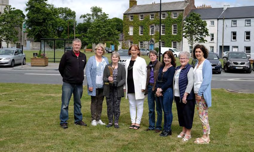
Chapter 1 Introduction

1.1 Background to Community and Participatory Planning

According to the Atlas of the Irish Rural Landscape (1997), each village is distinctive and

unique. They create a significant sense of regional and local character based on the natural,

built and cultural heritage. This unique character is created by the interplay of architecture,

streetscape, boundaries, views, landscape features and cultural elements (Dargan, 2013). The

individual elements of these villages make up a set of historic clues that can explain the past

provided we know what to look for. These clues include tales of religion, culture, economics,

vernacular style and climate over long periods of time.

1.2 Durrow Development Forum

For the past 20 years, Durrow Development Forum, the lead group in developing this

Community Plan, have a strong track record of delivering key projects and programmes for the

benefit of all individual’s groups and communities in the area. The group are the lead

representative group for the village. In 2017, the group successfully applied for assistance

under the Rural Development Programme 2014-2020 for support to develop a five year

Sustainable Communities Plan.

The key objective of this initiative was to secure a “shared vision” for the future of Durrow

Village. This was to be achieved by:

    1. Working intensively with the community to strengthen and enhance community struc-

        tures.

    2. Producing a comprehensive Sustainable Community Plan which will inform actions for

        future community development of Durrow village.

                                                5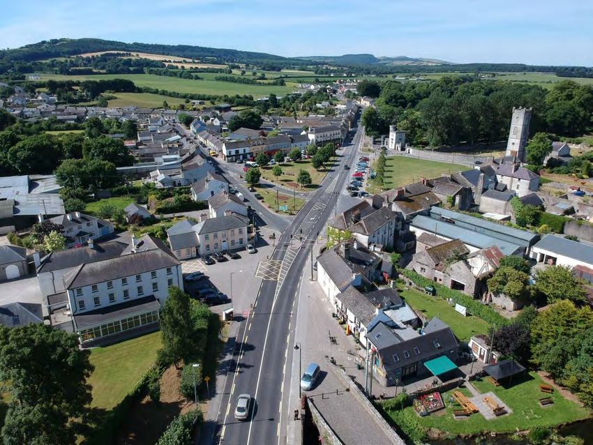
3. Identifying project proposals and preparing specifications for future funding applica-

        tions.

Figure 1: Some members of Durrow Development Forum, June 2018

A successful plan for Durrow cannot deal with spatial aspects in isolation from the social,

economic and environmental context. Of particular importance is the process by which

decisions are made and who makes them. The more people involved in decision making, the

more accurate and broad ranging the information base and the higher the chances of reaching

genuine agreement on key issues become. Therefore, participation by local people in the

process of developing the plan becomes as important as the plan itself (Tipperary Institute).

Since the mid-2000s, a significant shift in the need to secure meaningful public participation

has taken place at an international, European and national level.

The guiding principles used to assist with this community planning process included:

                                                6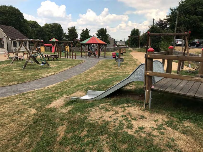
1. The plan was developed using an action planning model
    2. A commitment to working in an inclusive way
    3. Adopting an integrated approach to sustainable planning
    4. The Plan needed to be clear and accessible
    5. The Plan should devise structures to support its implementation

This Community Plan will provide significant assistance for decision makers and a context for

future planning, enabling an accurate and informed assessment of the potential impacts of

new development proposals.

1.3 Consultation Process

Extensive preplanning took place to ensure appropriate representative views were captured

and collated at a public consultation meeting which was held on the 25th January 2018. The key

aim was to recruit broad representation from community groups, businesses and elected

representatives. The workshop covered the preparation of a local resource audit, a SWOT

Analysis (Strengths, Weaknesses, Opportunities, Threats) and an indicative priority Programme

Action Plan.

Recruitment for the event was undertaken with the assistance of local social media, local

newspapers and extensive one to one telephone contact with many of the above stakeholders.

A follow up workshop with members of the Development Forum was held on the 15th February

2018. A number of follow up telephone interviews were held with individuals who expressed

an interest in elaborating in more details their views on the future of the area. A number of

written submissions further aided the collation of key information and views for the plan.

                                               7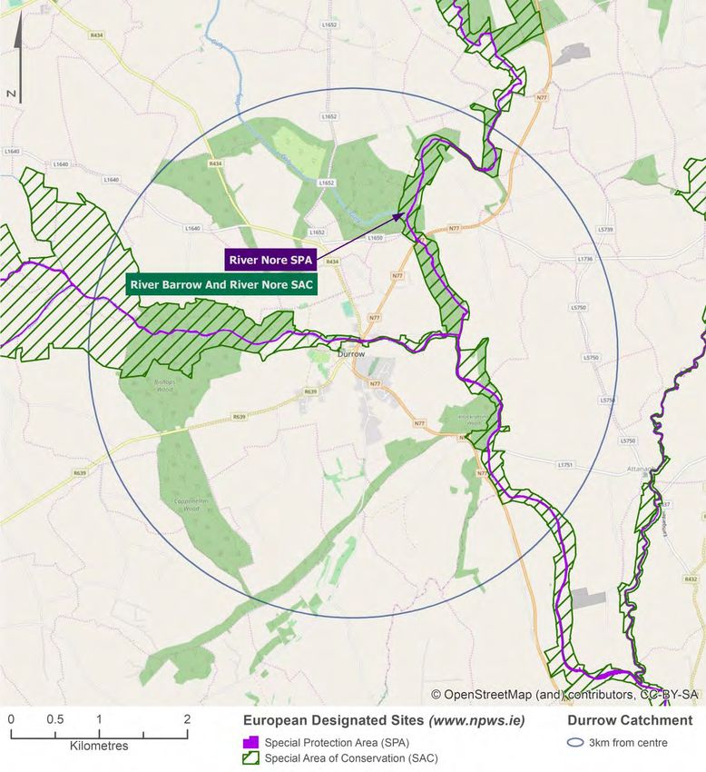
1.4 Summary findings of Resource Audit

 Theme                      Resource
 Economic                   Employment Opportunities
                            Quality of Local Businesses
                            Bespoke Auction House
                            Range of local hospitalities, eateries & accommodation
                            5* Hotel
                            Central Location
                            Good connectivity (buses, taxis)
                            Residential homes are affordable
                            Numerous points of interest
                            Limited dereliction & No ghost estates
                            Good Broadband Service
                            Financial institutions have been retained
 Social Capital             People
                            Community Ethos & high level of Volunteerism
                            Strong Local Social Media Platform
                            High Quality Festivals (Scarecrow & St Patricks Day Festival)
                            Range & Quality of Sporting Clubs
                            Range & Quality of Community Groups
 Community                  Community Playground
                            Cycling Routes
                            Community Employment Programme
                            Extensive range of events
                            Central Green is the heart of the village
                            Community Services (meals on wheels)
                            Umbrella Community Structure
                            Good quality primary schools, playschools & childcare service
                            High Quality Walks (e.g. Leafy Loops)
                            Post Office
                            Library
                            Fire Station
 Natural & Built Heritage   Natural Landscape (e.g. Rivers, Walks, Woods)
                            High Quality Built Heritage
                            Heritage (Tangible & Intangible)
                            Durrow Castle
                            Fishing

                                            8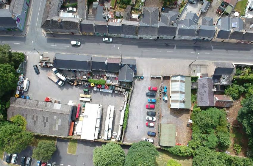
1.5 Strengths, Weaknesses, Threats, Opportunities

The summary views of attendees at the public meeting, telephone interviewees, written

submissions is show below.

                   Strengths                                         Weaknesses

 High Rates of Volunteerism & Community             Lack of befriending service
 Spirit                                             Signage cluttering on approach roads
 Natural Resources                                  Carpooling taking up valuable central car
 Location                                           spaces
 Local Services (banks, post office)                Lack of facilities for older teenagers & old
 Employment Opportunities                           People
 Range of festival & events                         Limited Police Presence in village
 High Quality Broadband                             No public toilet
 Strong Local Social Media Platform                 Loss of Civil Defence Service
                                                    Lack of designated business/industrial park
                                                    Limited Public Lighting
                                                    Limited Public Transport
                                                    Limited land banks to develop new recrea-
                                                    tion projects
                                                    No local housing for the elderly
                                                    Lack of Hostel
                Opportunities                                            Threats

 One way traffic system                             Rural Crime
 Retirement Village / Supported Housing for         Flooding / Climate Change
 the Elderly                                        Business Rates
 New Community CCTV Initiative                      Drugs & Anti-Social Behaviour
 Develop signage strategy for all approach          Security of CES
 roads                                              Speeding
 Seek news uses for old Civil Defence & Old         Volume of Traffic
 Methodist Church                                   Future of vital services (post office, banks,
 Maximise usage of existing community cen-          hospital, library)
 tre
 Completion of the Square Project
 Develop Community based car parking solu-
 tions
 Dredging of River & Repair of Old Bridge

1.6 Location

Durrow is a beautiful, small town in the south of Co. Laois close to the border with Co. Kilkenny

with a rich built heritage and natural environment.

                                                9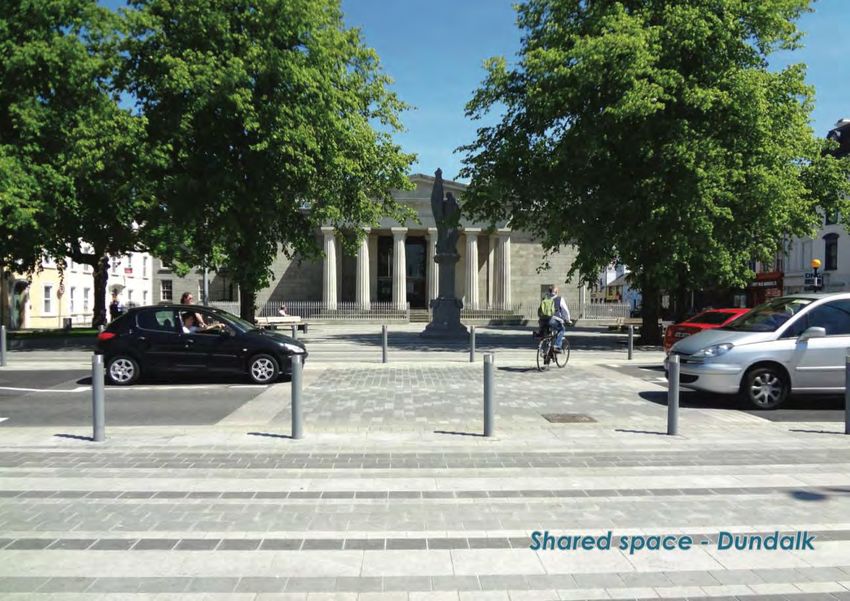
Figure 1.1 Location Map of Durrow and its hinterland
The earliest recorded mention of the area was in the fifth century, as the reputed birthplace of

St. Benedict (Durrow Architectural Conservation Area (ACA) Study, 2010).

Durrow is located in the fertile lowlands of Co. Laois, between the higher lands of the Slieve

Blooms and the Castlecomer Plateau. The town is surrounded by Countryside that is hill in

character (Figure 1.2).

                                               10
Figure 1.2 Aerial View of Durrow and its hinterland to a 3km radius
The River Erkina flows through Durrow before it joins with the River Nore on the eastern side
of the town. There are important protected habitats for plants and animals along the rivers,
know as Special Areas of Conservation (SAC) and Special Protection Area (SPA) (See Figure 1.3).
Durrow is also enriched by mature trees and wooded areas that enhance the character of the
settlement.
11Figure 1.3 Special Areas of Conservation and Special Protection Areas around Durrow
The town follows a street pattern that dates back to the 18th and 19th centuries and is
developed around The Square – a green space in the centre of town. The northern side of the
Square has many fine Georgian buildings, while commercial buildings are located on other
sides of the Square. Buildings in Durrow are typically 2-3 storeys in height (Figure 1.4). The
12central part of the town has been designated as an Architectural Conservation Area (ACA) to
preserve the special character of the historic core.
Figure 1.4 Aerial view of the centre of Durrow
Castle Durrow is an important landmark building, set in its own demesne, but with its entrance
on to The Square. It is actively used as a Country House Hotel, is regularly used as a wedding
venue and is an important source of employment for the town.
The town has a strong business and enterprise focus, with a number of transport and logistics
companies benefitting from Durrow’s central location. There is a thriving tourism industry with
three hotels; a number of B&B’s and guesthouses; and a strong wedding sector. There is a
tradition of high quality dining in Durrow dating back to when the town was a key stop-off
point on the road between Dublin and Cork, before the town was bypassed by the M8 in 2010.
131.7 Population Profile
Today the Durrow Electoral District (ED) has a population of 1,258, according to census 2016.
The Durrow ED includes the town of Durrow and its immediate hinterland (Figure 1.5). The
population has been remarkably consistent over the last 10 years, with a fall in the population
of just four people between 2006 and 2016. In contrast Co. Laois as a whole was one of the
fastest growing counties in Ireland, with a population increase of 26% from 67,059 to 84,697.
This population increase for the county was as a result of large parts of Co. Laois becoming a
commuter suburb of Dublin. This commuter effect, however, has had less impact on Durrow.
Figure 1.5 Durrow Electoral District
A review of the population pyramid for Durrow shows the percentage of people in different
age ranges of both males and females living in the Durrow Electoral Division (Figure 1.5).
Comparing Durrow’s population pyramid with the State’s pyramid (Figure 1.6), shows a similar
age pattern for most age groups, but there are fewer men and women aged 20-24 in Durrow
than the national figures, and more people in the 60-64 age range. Housing provision for this
older population will need to be planned.
14Figure 1.6 Durrow Population Pyramid Census 2016
Figure 1.7 State Population Pyramid Census 2016
Pobal is a Government and EU funded body set up to tackle disadvantage and support social
inclusion. Their Deprivation Index maps allows us to assess deprivation levels within a
15community based on census data (Figure 1.8). The map shows that the population living in
Durrow town are marginally more deprived than the average in Ireland, while the population
in the hinterland outside the town are marginally less deprived.
Figure 1.8 Pobal’s Deprivation Indices for Durrow
1.8 Plan Context
This plan is a community driven plan that has been led by the people of Durrow in its
preparation and implementation. A community led approach contributes not only to
ownership of the plan but also to the subsequent implementation and to monitoring the
outcomes. The process offered everyone in the community the opportunity to shape the
future of their town.
16Participation by the local community in the process of developing the plan is as important as
the plan itself. Active participation of local people in the planning and development of the area
where they live is itself a positive outcome. When people are empowered to participate in
planning, the result is not just a better final product but an improved relationship between
local people and the agencies tasked with implementing the plan. This leads to improved
decision making and ultimately, better planning and better delivery of local services.
This community plan is consistent with the objectives of the Laois County Development Plan
and through extensive consultation with the public, the plan reflects the aims and aspirations
of the community of Durrow.
The plan was prepared in response to an invitation from the Durrow Development Forum to
develop a Sustainable Communities Plan for the town, using public consultation to develop
policies and projects for the ongoing development of the community. The plan builds from a
series of previous plans and studies for Durrow carried out over the last 20 years. Many of the
recommendations of previous plans have been implemented. The plan will highlight the main
issues facing Durrow today.
Previous plans include:
• The Durrow Village Design Statement 2002
• Durrow Town Plan 2007
• Durrow Architectural Conservation Area Study 2010
• Durrow Laois Heritage Action Plan 2012-2015
• River Erkina Blueway report by Andy Dunne of EAEC Ltd. (2016)
17This plan must be consistent with local, regional and national plans and guidelines:
• Project Ireland 2040: National Planning Framework
• Midland Regional Planning Guidelines 2010-2022
• Laois County Development Plan 2017-2023
• Laois Local Economic and Community Plan 2016-2021
• The Design Manual for Urban Roads and Streets (Department of Transport, Tourism and
Sport, 2013)
18Chapter 2 Social, Community and Economic Development
2.1 Community and Social Infrastructure
2.1.1 Redevelopment of Methodist Church and Civil Defence property on Patrick Street
The Laois County Development Plan (CDP) 2017-2023 (p. 53) highlights the importance of
providing local facilities for community, voluntary, social inclusion and environmental groups
to meet and progress their work. The plan contains a specific objective for Durrow (DU24) to
develop additional community and sporting facilities which are flexible and capable of being
managed for a number of different uses.
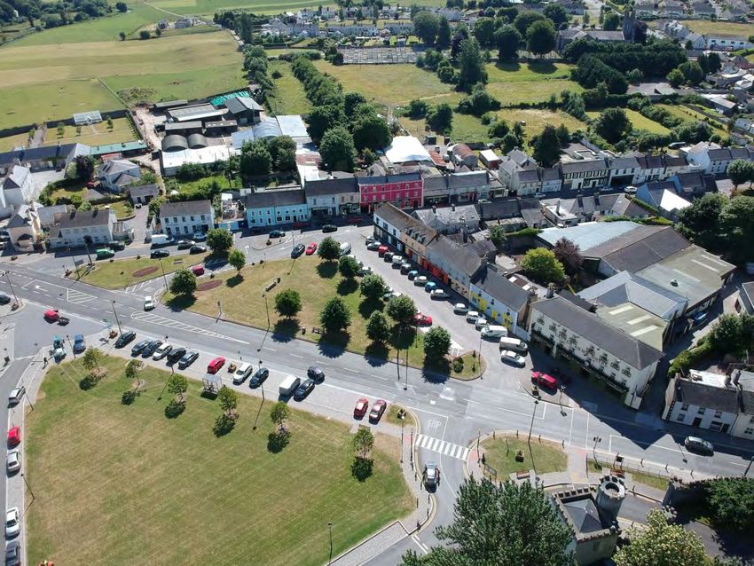
The community consultation carried out for this plan identified the Methodist Church and the
adjacent Civil Defence property as a potential new community space (Figures 2.1 & 2.2). The
Methodist church is on the record of protected structure in the Laois CDP.
Figure 2.1 Community Centre Site boundary outlined in red (Includes adjoining local
authority car park)
19Re-using these buildings would be in line with objective DU3 of the CDP to encourage
redevelopment or restoration of derelict, vacant or underused buildings within Durrow town
centre.
Figure 2.2 The Methodist church and adjacent Civil Defence property could be a potential
new community space
In order for this community facility to be successful it should aim to have as many uses as
possible. A good model is the Axis theatre in Ballymun (Figure 2.3). A survey of residents by
Ballymun Regeneration Ltd showed that 70% of local residents attended the Axis theatre
regularly. The basis of success of the Axis theatre is the multi-use nature of the building. It
combines a café that serves breakfast and lunches, with a theatre space, rehearsal studios,
dance spaces, crèche, community rooms and office space.
20Figure 2.3 Axis Theatre, Ballymun, Dublin
2.1.2 Rationale for Investment in Community Facilities
Community facilities represent the physical space where community members:
- Deepen their civic relationship with and commitment to their community
- Meet other community members socially, both formally and as part of a defined group
- Participate in sports, drama or other interests, actively or as a spectator
- Conduct voluntary activities that are of benefit to the whole community
- Accept the services offered by the community
In many ways, the well being of a community is mirrored in the appearance of and usage of its
physical structures. Over the years many community facilities have fallen into disrepair while
some communities have lacked this essential amenity. With many smaller communities facing
decline in population and services, the strengthening of such communities is vital to their
sustainability. Investment in community facilities is more about people as much as is about
bricks and mortem. A facility designed by the community leads to increased activity in sports,
community arts and community education.
212.1.3 Policy Context
The need for such high quality community facilities is referenced in a number of documents.
The 2007 Durrow Village Plan restates the local authorities policy of encouraging the provision
and further development of community facilities which are flexible and capable of being
managed for a number of different uses and to encourage the further use of existing facilities.
More recently (2016) in the Laois Local Economic and Community Plan (LECP), the high level
goal (G9) seeks to develop and promote ways of living and doing business that support a
sustainable environment. Objective B4 seeks to ensure conservation, active use and enhanced
presentation of buildings of special architectural or historic interest. The Architectural
Conservation Area objectives states that Laois Co. Co. should actively seek to support viable
uses for derelict sites. The proposal by Durrow Development Forum is consistent with above
policy objectives.
2.1.4 Durrow Community Centre: Key Funding Challenges & Needs Analysis
The key challenge in developing facilities is access to clean title or of a leasehold that is of
sufficient length so as to comply with the regulatory requirements of key funding programmes.
Durrow Development Forum have considered a number of potential options such a) as
developing a new facility on a green filed site or b) to select an existing facility for extension
and modifications. The group quickly came to the conclusion that a green field option was not
viable or sustainable as the existing limited resources would need to be fully expended on the
site purchase. A decision was quickly arrived at to focus on the old Methodist church site as
the key advantage was the availability of the adjoining disused civil defence building. The
availability of clean title for the old Methodist church/ICA Hall and a leasehold of the adjoining
building coupled with it’s central location were the main reasons for its selection as the
priority site for investment.
22The consultation process has identified many groups requiring access to facilities and activities
that cannot take place due to limited or no access to appropriate community facilities. This
includes meeting and activity space for youth and community groups such as the local Folk
Choir, Scarecrow Festival, Men’s Shed Project, ‘Hot Desking’ Space amongst many others.
Community Arts Activity has seen a significant increase in over the past number of years so the
design of a fully functioning multi purpose space has well advanced by the group.
Needs identified through the community consultation and interviews which informed the
design of the new facility includes:
• Rehearsal space
• Dance studio
• Community Meeting space
• Choir rehearsal
• Community Theatre and performance space
• Community kitchen
• Youth Café/space in the evening
• Men’s shed
• Hot desking for daytime use
2.1.5 The Proposal
The aim of this project is to fully restore the existing old Methodist hall and adjoining old civil
defence building into a multi purpose community activity facility.
Figure 2.4 Contiguous Existing Street Elevation of the two facilities on Patrick Street,
Regional Road R639
23The proposal is expected to be completed in two phases. The former building had undergone
preservation works over the past number of year including major repairs to the roof and
windows. The facility however lacks many of the additional functional services expected of a
contemporary community facility such as kitchen, disability toilets, heating and meeting
facilities such as projection equipment. The adjoining civil defence building is in need of a
significant overhaul and requires demolition and rebuilding (See Figure 2.2).
The design of the community centre was by an accomplished conservation architect who had
the capacity to design for the new emerging needs while preserving elements of the old
Methodist Church. The proposed centre is shown in Figure 2.5.
Figure 2.5 Elevation of Proposed Community Centre
2.1.6 Multi-Use Games Area (MUGA) and pitch for Soccer Club
The community consultation highlighted the need for a MUGA and the need for a pitch for the
soccer club. These could be jointly developed as a single project if a suitable site is found.
The project is more likely to be successful and more likely to get funding if a range of uses for
the facilities can be identified. The MUGA, as its name suggests, is suited to a wide variety of
24sports. As many local sporting clubs as possible should be involved in this project including
GAA, rugby and soccer clubs. The local primary school should also be involved with the bid, as
they can use the facilities during weekdays when other use is likely to be limited. The facility
should also cater for niche sports such as bowls, which might attract senior citizens to use the
facilities at off-peak times.
A site close to the town centre would be preferable to allow access for pedestrians and
cyclists. One possible site would be the land on the south bank of the river Erkina, to the East
of the town (Figure 2.6). This land is close to the centre of Durrow and is zoned for recreational
use. As it is adjacent to a Natura 2000 site (see section 4.3.1), any development would have to
be carefully managed to protect adjacent habitats. The site is in Flood Zone A, which means it
is prone to flooding at least once every 100 years, and the pitches may not be available when
water levels rise. This would have to be taken into account and the clubs would have to decide
whether the benefits outweigh occasional non-availability of the pitch. Access to the site is
available from the lane adjacent to the graveyard.
Figure 2.6 Potential site for MUGA and soccer pitch, outlined in red. This land is zoned for
recreation (Source, Bing Maps)
252.1.7 Play Areas for Children
There is an excellent playground next to the old primary school on the Kilkenny Road on the
outskirts of the town (Figure 2.7). This play area is close to residential housing and is
convenient for many families.
Figure 2.7 Playground beside the old primary school
There is a need, however, for more play spaces for children. The northern section of the
Square, in the town centre, close to the buildings and away from the main road would be a
good location for new play equipment (Figure 2.8). In addition, there could also be some adult
gym equipment on the Square. To enhance the play facilities, commercial establishments on
this side of the square should be encouraged to provide outdoor seating. This would allow
adults to have a coffee while watching their children. This setup of children’s play equipment
adjacent to coffee shops is very common and successful on the continent.
26Figure 2.8 The Northern side of the square would be a good location for play equipment and
to encourage seating outside commercial premises
In order to facilitate play equipment on the square, traffic calming would be needed for the
main road through the square. Traffic calming would be beneficial to the town for many
reasons and should be pursued whether play equipment is installed or not (see section 2.3.4).
2.2 Economic Development and Employment
2.2.1 Tourism
Durrow has an excellent tourism offer and should build on its strengths to attract more
visitors. The community consultation highlighted the need to promote Durrow, and develop a
logo for the town. One way to promote the town is to gather together all the tourism offerings
into a brochure, in both printed and online formats. These brochures should be available at all
hotels and guest houses, and there should be links to all available activities on all their
27websites. This will be of benefit to accommodation providers as well as to the businesses that
supply local services.
Visitors want to see a range of activities in the area such as walking, cycling, fishing, golf and
play activities for children. Durrow provides many of these opportunities, but there is scope to
improve the offer. The Laois Local Economic and Community Plan (LECP) developed by the
Laois Local Community Development Committee (LCDC) has an objective to grant aid new and
existing tourism products particularly activity-based tourism businesses (p. 30), and this grant-
aid should be pursued.
2.2.2 Building on the Successful Wedding Business
Durrow is a successful wedding destination with Castle Durrow (Figure 2.9), the Ashbrook
Arms, and the Castle Arms Hotel all hosting weddings.
Figure 2.9 Wedding at Castle Durrow (source www.weddingsonline.ie)
According to weddingsonline.ie 2018 survey, couples are spending an average of €26,000 on
their weddings and typically they invite 159 guests. While most couples honeymoon abroad,
half of couple’s “mini-moon” in Ireland. If Durrow can capture more weddings, and encourage
more couples and their guests to extend their stay, it could boost the spend in Durrow.
28Weddings provide business to more than just the hotels. Couples are spending on ancillary
services such as:
• Hairdressers
• Make-up
• Florists
• Car hire
• Horse and carriage hire
• Wedding Cakes
• Child minding
• Music for the ceremony
• DJs and bands for the reception
• Photographers and videographers
• BBQ service for the day after the wedding
Potential wedding parties when choosing their wedding location are keen to source these
services locally, but often find it difficult to research their options. A coordinated effort by
suppliers to provide an up-to-date listing of services to wedding venues would encourage
more weddings to come to Durrow. There should be links to the services on the wedding
venue’s websites as well as a printed brochure that should be updated annually.
Spillover accommodation is often required for guests, and this is an opportunity for small guest
houses, traditional B&B’s and for Airbnb style accommodation. Bed and breakfast or Airbnb
options on local farms might be attractive for some guests. One suggestion in the community
consultation was the idea of developing a “Community Hostel”. Such a hostel would also help
provide spillover accommodation for weddings.
Durrow would also benefit from a listing of all local activities and attractions (see section 2.2.1)
that would encourage the wedding couple and their guests to stay before and, or after the
wedding.
292.2.3 Buildings for Businesses
There is a shortage of empty units for new businesses to locate in Durrow. There are sites
zoned for enterprise and employment on the outskirts of Durrow, but there is no sign of this
opportunity being taken up.
One way to provide extra space would be to ensure that all existing commercial buildings are
being used to their full extent. There has been a lot of attention given to the idea of using
upper floors of commercial buildings for residential accommodation. But often upper floors
are more suited to commercial use. Good examples of upper floor use include:
• Accountants
• Solicitors
• IT start-ups
• Medical services
A survey of all commercial buildings should be carried out to identify underused or vacant
floors that would be suitable for small business.
The community consultation highlighted the idea of setting up an industrial/community
kitchen. This could be in the proposed new community centre in the Methodist church and
Civil Defence buildings, or the survey of commercial buildings could be used to identify other
options. A community kitchen could be an opportunity for local producers to supply food.
Hot desking is a way of providing office space for start-ups and small businesses. This facility
would allow them to share office space and encourage networking and innovation. The
proposed new community centre could be a location for hot desking. This would help ensure
that the building is well used during the day. Other possible locations for hot desking could be
identified through the suggested survey of commercial buildings.
30A therapy room is a room suitable for a variety of therapists and medical practitioners to rent-
out on a part time basis. For example a physiotherapist might rent out the room one afternoon
a week, while a psychotherapist could rent the room one morning a week. This allows a range
of services to be offered in Durrow, that wouldn’t otherwise be possible. The website
www.therapyrooms.ie can be used as a booking service for the room. Again a suitable room
could be provided in the proposed new community centre, or an alternative location could be
found in the survey of commercial buildings. For many medical practitioners the room would
have to be accessible for patients with disabilities.
2.3 Movement and Transport
2.3.1 Improvements for Pedestrians
The pedestrian is often treated as an afterthought when transport is considered. Yet all
visitors, shoppers, residents and workers have to walk (or use a wheelchair) for some part of
the journey. The Department of Transport, Tourism and Sport, however, states that
pedestrians must be placed at the top of the user hierarchy in the design of streets (Design
Manual for Urban Roads and Streets, p.28) (Figure 2.10).
31Figure 2.10 Priority for street design (Source, Design Manual for Urban Roads and Streets)
We should also design our streets to be accessible to all, so footpaths need to be wide enough
for wheelchairs and buggies, and should not be blocked by street clutter or parked cars
(Figures 2.11 and 2.12). Objective DU22 of the Laois CDP sets out the need to facilitate
mobility and movement of people with special needs in Durrow by providing:
32• dished kerbs at crossing points
• level footpath surfaces
• tactile pavings
• audible traffic light signals for pedestrians
• disabled parking spaces in strategic locations
• ensure that slopes that form part of the pedestrian network do not exceed 1 in 5.
Figure 2.11 The footpath on both sides of Chapel Street are obstructed by parked cars
33Figure 2.12 The footpath on Mary Street is not particularly wide, but are not obstructed by
street clutter or inappropriate carparking
2.3.2 Facilitating Cycling in Durrow
Cycling is not a significant mode of transport in Durrow. Just two people reported cycling to
work in Census 2016, and not a single pupil reported cycling to school or college. But if Durrow
is to encourage more local residents to cycle, or to attract cycling-based tourism, more will
have to be done to facilitate cyclists. In particular there needs to be places for people to
securely lock their bikes. This means Sheffield stands are needed (Figure 2.10), so that cyclists
can easily lock the frame of the bike, and not just the wheels. One car parking space is enough
room for five Sheffield stands which would allow 10 bikes to park. The Laois CDP contains
objectives to provide cycle parking at buildings in community use, especially schools (DU20)
and to provide cycle parking in association with the existing bus stopping area (DU23).
34Figure 2.13 Bikes locked to Sheffield stands in Drumcondra, Dublin
In order to boost cycling by local residents around the town, a series of traffic calming
measures will be needed, and these will be discussed in section 2.3.4.
Cycle training in school can be very effective at encouraging children to cycle. For example,
Dublin City Council provided cycle training to St. Fiachra’s primary school in Beaumont (Figure
2.14). Before the cycle training 10 pupils were cycling to school. Six weeks after the training
110 were cycling to school. There is more likely to be buy-in from parents for cycle training if
successful traffic calming measures are introduced into the town (see section 2.3.4).
35Figure 2.14 Cycle training for the pupils of St. Fiachra’s School in Dublin was very successful
at encouraging children to cycle to school
2.3.3 Parking in Durrow
The thorny issue of parking in the town centre came up in the public consultation. A particular
problem was identified with car-pooling commuters parking their vehicles in the centre of
town all day.
Before drastic steps are taken to address the parking situation it is important to assess the
severity of the problem. A survey should be carried out a number of times at peak car parking.
If fewer than one in eight spaces are free on a regular basis, then action will be required. And
the best way to deal with commuters hogging vital car parking spaces is to introduce paid
parking in Durrow.
A car parking location for the car poolers should be identified. Car parking could be provided in
the backlands behind Mary Street (Figure 2.15). Access could be through one of the existing
archways. The archways are only 3-4m in width, which is not wide enough for two-way traffic,
36but a simple yield system would allow one vehicle in or one vehicle out. If parking could be
provided in such a central location, it would allow for a reduction of parking elsewhere,
especially on the square.
Figure 2.15 The backlands behind Mary Street would be an excellent location for car parking,
if access can be acquired
Another possibility for car parking for car poolers is the car park of the local GAA club, which is
usually not busy during the working day. Another alternative is the site zoned Enterprise and
Employment (Figure 2.16). It is close to the town centre and a pedestrian linkage across the old
bridge could be provided. This would require a rezoning of some of the Enterprise and
Employment lands.
37Figure 2.16 Suitable Site for Re-development
New high quality parking bays have been installed on one section of the square (Figure 2.14).
There are also plans to upgrade the parking outside the Castle Arms Hotel on the Square
through the Phase 2 works of the Square Upgrade (Transport Infrastructure Ireland (TII)). Any
upgrade should provide charging terminals for electric cars. This will encourage local residents
to switch to electric cars, but could also encourage travellers on long-distance journeys to take
a break in Durrow to charge their car. It is an objective of the Laois CDP (DU22) to facilitate
mobility and movement of people with special needs by providing disabled parking spaces in
strategic locations in particular at buildings in community use.
38Figure 2.17 New car parking bays on the completed Phase 1 Square Upgrade (centre). Note
Phase 2 of the Square Upgrade will incorporate improved car parking layouts and improved
street furniture
2.3.4 Traffic Calming
A striking feature of Durrow is the large number of HGVs rattling through the narrow streets
(Figure 2.18). This is a particular problem on residential streets such as Patrick Street and
Carrigan Street, where there are no front gardens to act as a buffer against passing traffic. Not
only are the HGVs noisy and dangerous, they also generate heavy vibrations, which must
impact on the quality of life of the residents of these streets. The problems caused by the
traffic may be why so many homes are vacant in the town centre (see section 4.1) and it will
become increasingly difficult to attract families to live on these streets, unless something is
done to alleviate the traffic impacts.
39Figure 2.18 HGVs are having a serious impact on the quality of life for residents in Durrow
Every effort should be made to advocate for a bypass or ring-road around the town. In the
meantime steps should be taken to calm traffic moving through Durrow, to mitigate the
effects of HGVs and to make the town more pedestrian and cycle friendly.
Narrow carriageways are one of the most effective design measures to calm traffic (Design
Manual for Urban Roads and Streets, p. 101). This technique should be applied to Castle
Street/Patrick Street, and to Chapel Street/Carrigan Street, where the carriageway could be
reduced to 5-5.5m (i.e. lane widths of 2.5-2.75m). Roads through the Square should be raised
to create a shared surface and narrowed to 4.8m or less. This would help make the square feel
like a single community space rather than separate sections of open space and more in
keeping with the original design of the town. It would also significantly slow down traffic and
make the use of the square safer for children, and reduce traffic noise (Figure 2.19).
40Figure 2.19 Shared surface in Dundalk (Source, Design Manual for Urban Roads and Streets)
Narrowing roads will not only calm traffic, but will also provide opportunities to provide wider
footpaths, tree planting (Figure 2.20) and extra car parking spaces – all of which would further
contribute to traffic calming, and all would be particularly beneficial for the residents of Patrick
Street and Carrigan Street.
Figure 2.20 Mock-up of Carrigan Street with trees
41Traffic calming should also start at the entrance to the town, where there are opportunities to
provide some extra greenery (Figure 2.21).
Figure 2.21 Grass and tree planting would encourage traffic calming and improve the public
realm at the entrance to Durrow on the R639/Cork Road
For traffic coming from Mary Street on to Carrigan Street, there is a gentle bend which allows
vehicles to pick up speed as they turn this corner (Figure 2.22). A sharper bend would help
slow down the traffic, in particular for larger vehicles (Design Manual for Urban Roads and
Streets, p. 93).
42Figure 2.22 The gentle corner coming from Mary Street to Carrigan Street allows trucks to
pick up speed
A new one-way street system was suggested during the consultation. If done properly this
could help calm traffic in the town centre and could bring many benefits. It should, however,
only be implemented if the number of lanes on each street is reduced to one – to allow for
wider footpaths, tree planting, and car parking (Figure 2.21). If two lanes of traffic are kept on
one-way streets, speeds would increase from their current levels, and it would make the town
centre a less attractive place to live in or to visit.
43Figure 2.23 Francis Road in London before and after being reduced from two-way to one-way
traffic with one lane
If traffic calming is introduced in Durrow, the next step would be to reduce the speed limit to
30kph. Introducing a lower speed limit before any traffic calming is less likely to be effective. A
successful 30kph zone would improve safety, reduce traffic noise, make Durrow more
attractive to visit, and improve quality of life for residents on Patrick Street and Carrigan
Street.
44Chapter 3 Culture and Heritage
3.1 Arts and Culture
3.1.1 Introduction
The Arts can bring delight, joy and the full range of human emotions and they are an important
way for people to get a deeper understanding of themselves, their community and their
circumstances in life. The arts are a vital part of the life of any strong community and should
be at the heart of any plan for Durrow (Figure 3.1).
Figure 3.1 A thriving Community Arts Community. E.g. Durrow Scarecrow Festival 2018
The proposed renovation of the Methodist Church and Civil Defence building for community
use should be an important venue for the Arts in Durrow. It should provide a performance
space for theatre, dance, music and an exhibition space for the visual arts.
Sculpture has been used in a tasteful way to improve the public realm in Durrow (Figure 3.2)
and there is scope for more.
45Figure 3.2 Sculpture on the Square brings delight to visitors
463.1.2 The Scarecrow Festival
The Scarecrow Festival has been a great success for Durrow (Figure 3.3), enticing up to 27,000
visitors, while increasing spend in local businesses, and raising funds for the Durrow
Development Forum and key initiatives within the community.
Figure 3.3 The Scarecrow Festival has attracted many visitors to Durrow
But there is a need, as identified by the community consultation, to develop spin-offs or to
plan for alternative festivals for Durrow if and when the Scarecrow Festival starts to fade in
popularity.
3.1.3 The Development of Interpretative Centres & Museums
There are a number of quirky and offbeat museums in the area including the bicycle museum
in Bob’s Bar Durrow and The Fly Fishing and Game Shooting Museum in Attannagh. The
recently setup Aylward Country Life Museum just Outside Durrow is a new offering to the area
47and consolidates the number of visitor attractions. These promoters should be encouraged to
collaborate and “package and cluster” their offerings with the other museums.
3.2 Built Heritage
3.2.1 Built Heritage Introduction
Durrow has an outstanding built heritage and the local community deserves credit for curating
their heritage and for restoring vacant and dereliction buildings. Studies carried out on behalf
of the town include:
• Durrow Architectural Conservation Area Study, 2010
• Durrow, Co. Laois, Heritage Action Plan 2012-2015
The village that we see today dates back to the 18th century and was developed under the
ownership of the Flower family. Sir William Flower became the owner of the Castle Durrow
estate in 1708 and it remained in his family’s possession until the early 20th century. The
family built the castle, which was completed in the 1730s and they developed a planned village
of 218 houses by the end of the 18th century (Durrow Architectural Conservation Area Study,
2010 p.7). The street layout that exists today can be seen on the first edition Ordnance Survey
map from 1841.
Durrow town centre was designated as an Architectural Conservation Area (ACA) with the
adoption of the 2011-2017 Laois CDP (Figure 3.4). In addition, more than 30 buildings and
structures in the town are on the record of protected structures in the current Laois CDP.
48Figure 3.4 Boundary of Architectural Conservation Area
The designation as an ACA has implications for future development in Durrow. Development
that could normally be carried out without planning permission – so called “exempted
development” – may require planning permission. Within an ACA, exempted development is
limited to works that do not affect the appearance of a building from the public domain. For
example the addition of a porch to a house would normally be considered as exempted
development, but such development would require planning permission in Durrow.
3.2.2 Future Enhancements to Built Heritage
• Vacant and derelict buildings (Figure 3.5) should be brought back into use as quickly as
possible. This may require the council to use their compulsory purchase powers, and is in
line with objective DU3 of the Laois CDP.
49• Upper floors should also be used to their full potential, and as stated in section 2.2.3,
upper floors are often very suitable for businesses such as accountants, solicitors and
medical practitioners.
• A start has been made on the renovation of the historic square in the centre of town, and
this renovation needs to be completed.
• Where possible, overhead wiring within the ACA should be moved underground
(Objective DU25 Laois CDP)
• The temporary weir on River Erkina at the Old Stone Bridge should be repaired or
replaced (Objective DU9 Laois CDP)
• Shopfronts should be encouraged to have timber frames and hand painted lettering. The
Laois Local Economic and Community Plan has an objective to run a shopfront grant
scheme (Objective A10 under Goal 10). This could be an opportunity to employ local
craftsmen.
• Lamp standards should be consistent and suitable for a heritage town
• The Old Stone Bridge needs significant attention (Figure 3.5). A report commissioned by
the Durrow Development Forum in 1999 by Pat McAfee highlighted the danger to the
future stability of the bridge caused by the presence of the weed/wild flower Valerian.
• The Scout Hall on the Kilkenny Road is a very attractive building and is on the record of
protected structures. The building at the back of the hall appears to be of poor quality and
detracts somewhat from the Scout Hall (Figure 3.6). A future project may be to demolish
the building at the back and replace it with something more appropriate. It might be a
good location for an indoor sports hall, if funding can be identified.
50Figure 3.5 Derelict building on Patrick Street
Figure 3.6 The Old Stone Bridge is heavily infiltrated by Valerian which could damage the
future stability of the bridge
51Figure 3.7 The building at the back of the Scout Hall detracts from the Scout Hall and could
be replaced with something more attractive and more beneficial to the community
52Chapter 4 Housing, Key Development Sites and Environmental and Public Realm
Improvements
4.1 Housing
The Laois CDP (p. 32) currently projects an increase of 46 extra households in Durrow by 2023.
This projection, however, will be reviewed following the adoption of the Regional Spatial and
Economic Strategy by the Eastern and Midland Regional Assembly in the coming months. At
the permitted density of 14 units per hectare, three hectares of residential development is
required within the town. The Laois CDP allows housing in lands zoned for “Residential 1” and
“Residential 2” (Figure 4.1). In addition, housing is open for consideration in the land zoned for
“Town Centre” and on “Community, Educational and Institutional” land. Although housing is
allowed on land zoned for Tourism, it is for accommodation for tourists, rather than housing
for permanent residents.
Figure 4.1 Zoning Map for Durrow
53“Residential 1” is land that has already been developed for housing, but additional housing can
be built as well as uses that enhance the amenity of those living there such as schools, small
shops, doctor’s surgeries, playing fields, etc. (Laois CDP 2017-2023, p. 181).
An important way of providing housing is to bring vacant properties back into use. Twenty-
nine of the 100 housing units within the town centre were vacant in 2016 – a worrying vacancy
rate of 29% (Figure 4.2). The 29 vacant units do not include holiday homes. The remainder of
the Durrow Electoral District, has 39 vacant units out of 464 – a vacancy rate of 8.4% (Census
2016).
Figure 4.2 The centre of Durrow has a vacancy rate of 29% according to Census 2016
If buildings remain vacant for extended periods of time, they will fall into disrepair and
dereliction. This would have serious implications for the attractiveness of Durrow, and would
cause significant damage to the built heritage within the town. A loss of population within the
town centre will also reduce the spending power within the town, and damage the viability of
many of the businesses and services in Durrow.
54Every effort should be made to reduce the vacancy rate within the town. A survey should be
carried out to identify all vacant units and to try and establish the causes of vacancy. One way
to bring these units back into use is through Approved Housing Bodies that have finance to
purchase, renovate and bring vacant properties back into use. The council may need to use its
compulsory purchase powers in some cases in order to bring homes back into use. Smaller
properties might be suitable for single people, such as senior citizens. This would be supported
by Housing Policy 9 of the Laois CDP to meet the needs of the elderly by providing
accommodation in central, convenient and easily accessible locations and to facilitate
independent living where possible;
“Residential 2” is land that is zoned for new housing development, as well as uses that can
enhance the amenity for new residents such as schools, small shops, doctor’s surgeries,
playing fields, etc. Most new housing is likely to be developed in this land. It may be possible to
attract buyers who might otherwise prefer a rural home, by offering plots of land for sale, so
that people can design their own home. This is the development process that appears to be
happening on the Mill Road (Figure 4.3).
Figure 4.3 Each house on Mill Road is built to its own design or ‘bespoke’ design
55There is a large amount of undeveloped land behind the existing streets in Durrow (Figure 4.4).
These backlands are largely zoned “Town Centre” which allows for a mix of uses, including
residential and commercial. While this land has important potential, because of its proximity
to the town centre, getting access to this land is a significant challenge. It’s not appropriate to
demolish historic buildings to allow access to the backlands – the purchase and demolition of a
modern infill house would be more appropriate (Durrow Architectural Conservation Area
Study, p. 48). An alternative approach to gain access to the backlands is through one of the
existing historic archways. These archways tend to be 3-4m in width, so they wouldn’t allow
standard two-way access, but a simple yield system, would allow one vehicle in or one vehicle
out at a time. A second point of access from the rear of the backlands would also be needed.
Any development in the backlands would have to be in sympathy with the size and scale of the
existing streetscapes.
Figure 4.4 An approximate outline of the land zoned as “Town Centre”. Note the significant
areas of backlands available for development
56You can also read