Fractal Geometry for Landscape Architecture: Review of Methodologies and Interpretations - WUR E-depot
←
→
Page content transcription
If your browser does not render page correctly, please read the page content below
72                                                                                              Full Paper

Fractal Geometry for Landscape Architecture:
Review of Methodologies and Interpretations
Agnès Patuano1, Ata Tara2
1
Wageningen University, Wageningen/Netherlands ꞏ agnes.patuano@wur.nl
2
Royal Melbourne Institute of Technology, Melbourne/Australia

Abstract: This paper presents the summary of a literature review of the methods and interpretations of
fractal geometry currently used in landscape architecture. Over 40 studies were examined for their use
of fractal concepts within the analysis of landscape-related elements. Although much work has been
done on the quantification of landscape parameters for the purpose of visual assessments and preference
predictions, the links between applied landscape design and fractal principles remain tenuous. Several
methodological hurdles, such as issues of signal transformation and segmentation, as well as the inev-
itable questions surrounding the ecological validity of landscape surrogates still stand in the way of
making fractal geometry a useful tool for landscape architects.
Keywords: Review, methodology, fractal geometry, fractal dimension

1      Introduction
Fractal geometry, the corpus of mathematical principles behind organic forms and patterns
as collated by Benoit Mandelbrot in 1975 (MANDELBROT 1975), is a topic of fascination within
both design disciplines and the environmental sciences, and landscape architecture is no ex-
ception. In fact, as the roots of the discipline are firmly planted in both arts and science, it
could be argued that no academic field is better suited to the study and application of fractal
principles.
This is particularly true when considering the many attempts at quantification of landscape
characteristics which have animated the discipline, most often in order to predict preference
through visual assessment (see for example some of the works derived from the Kaplans’
information processing theory (Purcell & Lamb 1998) or the work of Stamps (2002) on the
theory of fractal fit). For these endeavours, fractal geometry offers the seductive promise of
ordering chaos and distilling the complex nature of landscapes and of their elements into
simple numerical measures, still generally considered more manageable and persuasive than
qualitative data. However, publications on fractals from the landscape architecture perspec-
tive are few and far between, and practical applications of the geometrical principles them-
selves in the context of landscape design are yet to be explored.
Therefore, this paper attempts to produce a comprehensive review of the current state of
knowledge on the use of fractal analysis methods in landscape architecture and its close
neighbouring disciplines. This review includes both research and design contexts as long as
the unit of study is at the landscape scale and/or from a landscape-oriented perspective. In
doing so, this paper intends to answer two main questions: What are the methods of fractal
analysis currently used in landscape architecture? And how do they interpret or consider the
definition of its core concept, the fractal dimension?

Journal of Digital Landscape Architecture, 5-2020, pp. 72-80. © Wichmann Verlag, VDE VERLAG GMBH ꞏ
Berlin ꞏ Offenbach. ISBN 978-3-87907-663-5, ISSN 2367-4253, e-ISSN 2511-624X, doi:10.14627/537690008.
This article is an open access article distributed under the terms and conditions of the Creative Commons
Attribution license (http://creativecommons.org/licenses/by-nd/4.0/).

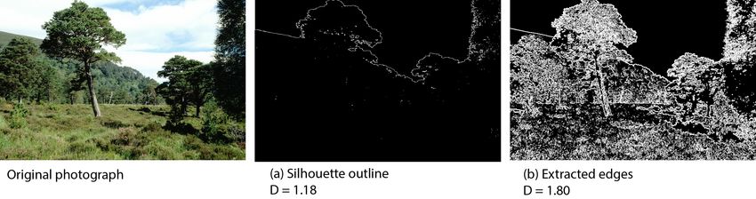
A. Patuano, A. Tara: Fractal Geometry for Landscape Architecture                               73

1.1   Definition of Terms and Concepts
Fractal geometry is less of a unified theory and more of “a collection of examples, linked by
a common point of view” (LORIMER et al. 1994, p.1) of mathematical methods to model nat-
ural forms such as coastlines and rivers.
Within this framework, Mandelbrot defined the necessary calculations to estimate the fractal
dimension (noted D or FD) a constant characteristic of the object of study. Although the
mathematical definition of that indicator is fairly clear, as it describes the power law relation-
ship between content and scale, the interpretation of the resulting numerical value (which is
without unit) is often up for debate. The main aim of fractal analysis is typically to estimate
that value.
There are many methods used to perform fractal analysis or produce fractal forms of specific
dimensions and their detailed description is beyond the scope of this paper. Interested readers
might want to refer instead to LOPES & BETROUNI (2009) and their excellent review of meth-
odologies.
Probably the most well-known approach is the box-counting method, based on the applica-
tion of grids of increasing or decreasing mesh size onto the selected pattern. By counting the
number of squares, or “boxes”, containing bits of the pattern for each grid, one effectively
analyses the content of the pattern at different scales. The resulting values can be entered into
a log-log plot against the dimension of the boxes at each stage and the curve thus traced has
a slope which approximates D.
However, this method has been heavily criticised for its limited application to binary patterns
and its sensitive analytical parameters which require careful consideration of the type of data
being processed (LOPES & BETROUNI 2009, OSTWALD 2013).Specifically, in order to know
what box to include in the analysis, a distinction must be made between the “object”, or pat-
tern which is the subject of the analysis, and the “background” which is the rest of the image.
This image segmentation can be particularly difficult to systematize in the case of landscape
photographs, where elements are not necessarily distinct from each other and the object of
study is the general view rather than discrete patterns. Different techniques of image trans-
formations have been tested, each with their own specific results (See Fig. 1, PATUANO 2018).

1.2   Review Methodology
Landscape Architecture is a multifaceted discipline which, much like the concept of land-
scape, its object of study, tends to resist a strict definition. For the purpose of this paper,
studies were considered relevant if they dealt with natural environments with built elements,
physical or perceived, and the shaping of these environments or the responses they induce.
Studies on fractal geometry were then originally collated in relation to visual perception of
natural environments then classified according to their field of study. They were then cate-
gorised by their dimensionality, that is whether the stimulus used as a basis for analysis was
one-, two- or three-dimensional, as this aspect greatly affects the applicable methodology.
Although this paper primarily focuses on the fractal analysis of real data (as opposed to the
production of digital fractal patterns of specific properties), studies investigating the percep-
tion of fractal dimensions through the use of digital surrogates were also considered.
74 Journal of Digital Landscape Architecture ꞏ 5-2020
Fig. 1: Different image segmentations yield different FD, from PATUANO 2018. Studies
from neighbouring disciplines were also considered with regards to the applicability
of their approaches to Landscape Architecture studies.
2 Results
Over 40 studies were compared ranging from 1981 to 2019, less than 10 of which could be
considered strictly Landscape Architecture, either because of their specific focus or the ex-
plicit affiliation of the journal in which they were published. Others come from fields as
diverse as Landscape Ecology, Soil Sciences, Vegetation Taxonomy, Environmental Psy-
chology, Urban Planning and Architecture.
2.1 Purpose of Using a Fractal Approach
Historically, although it was first harnessed by biological and physical sciences who used it
for its ability to accurately model complex and chaotic phenomena, the power of fractal ge-
ometry was soon applied to aesthetic concerns as a way to tease out the links between arts
and nature (SHORT 1991).
One aspect which seems consistent across disciplines is the hypothesis that FD is an estima-
tion of complexity, regardless of how that complexity is defined, be it a question of visual
variety (COOPER & OSKROCHI 2008), roughness of surfaces (PENTLAND 1984) or an amount
of information (FORSYTHE et al. 2011). However, some authors also noticed its correlation
with the presence or amount of vegetation (KELLER et al. 1987, CHALUP et al. 2009, COOPPER
et al. 2013) and, on this basis, some have also associated it with naturalness (PERRY et al.
2008, PATUANO 2018).
Regardless of how it is defined, FD is also generally considered a composite measurement
of several variables (COOPER 2003) and a statistical approximation of content across scales
rather than a precise measure.
2.1.1 In Other Disciplines
Fractal geometry is still commonly used in medical sciences, where it can be combined with
medical imagery as a diagnostic tool. For example, the fractal analysis of images of blood
vessels or cells can be used to reveal quantifiable changes and evolutions in the development
of pathologies (BANKMAN 2009). Disciplines such as these are some of the main drivers of
research behind the development of robust methods of fractal analysis which can then be
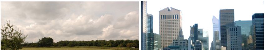
adapted to other objects of study.A. Patuano, A. Tara: Fractal Geometry for Landscape Architecture 75 A very fertile ground for the development of methodologies of fractal analysis which could be applied to Landscape Architecture studies seems to be Architectural studies, with many attempts to estimate the FD of architecture and surrounding context and the first applicable guidelines for the fractal analysis of real architectural or urban data being produced by OSTWALD (2013). Using this technique in “The Fractal Dimension of Architecture”, VAUGHAN & OSTWALD (2016) calculated the visual properties of eighty-five building designs and investi- gated how they relate to each other. However, they found it impossible to distinguish architectural styles using FD alone. By contrast, in urban design, COOPER (2005) was able to assess the fractal dimension of street edges by tracing building frontages using 1:2000 plan outlines and derive a typology of street characteristics based on these values. Nevertheless, Architecture has the advantage of working from fixed lines, with perhaps a more straightforward relationship between façade elevation on paper and the physical or per- ceived reality. 2.1.2 In Landscape Architecture Within Landscape Architecture, methods of fractal analysis are usually integrated into explo- rations of visual perceptions of landscapes, either through landscape visual assessments or for the purpose of preference studies (STAMPS 2002, HAGERHALL et al. 2004, PATUANO 2018, TARA et al. 2019). Similarly, many studies in and outside of the discipline used the fractal dimension of scenes as a way to perpetuate the long-standing tradition of systematic compar- ison between urban and natural scenes typologies (PERRY et al. 2008, WANG & OGAWA 2015). However, no study has yet managed to bridge the gap between research and practice by ap- plying fractal geometry to Landscape Design. The closest use of fractal principles in land- scape practice is through what is often referred to as “Biophilic design” (JOYE 2007, TAYLOR & SPROTT 2008), an approach to make the built environment look more natural by using shapes, textures and colours inspired by nature. However, even within this framework, fractal geometry is only used as an inspiration rather than an applied method. Furthermore, there is no equivalent approach appropriate to Landscape Design, which primarily uses vegetation rather than built forms, and is therefore already considered somewhat natural. Most notably, PERRY et al. (2008) have tried to tackle this question, acknowledging that, “although Baird (2002), and Spirn (1988), have suggested that fractal geometry could form the basis of a new aesthetic, no indication is given about how this might occur” (p. 6). They therefore undertook a pilot study to explore the development of an ecological aesthetic based on fractal geometry but realised that the way to perceived fractal patterns was not straight- forward. Indeed, as Mandelbrot warned, FD is not enough on its own to characterise an im- age, and two very different views can be assessed as having the same FD while looking noth- ing alike (see Fig. 2). 2.2 Methods Used for the Fractal Analysis of Real Data Although technology arguably gets better every day and could allow the production of increas- ingly realistic digital surrogates, a great deal of effort has been put into refining our ability to model real-life data and produce results directly applicable to real-life situations (CHALUP et al. 2009, HAGERHALL et al. 2004). When applying fractal geometry to the analysis of real data, most studies rely on the box-counting method or variants of it, regardless of the disci- pline (OSTWALD 2013, CHALUP et al. 2009, HAGERHALL et al. 2004).
76                                              Journal of Digital Landscape Architecture ꞏ 5-2020

Fig. 2: Two images of similar fractal dimensions but opposite typologies

The second most-used method is the fractional Brownian motion (KELLER et al. 1987, WANG
& OGAWA 2015). Methods of image segmentation and transformation vary widely between
papers.
Regardless of the method, the data used as landscape surrogate are often photographs (PERRY
et al. 2008), which typically need to be segmented prior to analysis, either as greyscale (PERRY
et al. 2008), silhouette outline (HAGERHALL et al. 2004) or extracted edges (PATUANO 2018).
These transformations each drastically alter the original data, by summarizing the infor-
mation contained within the digital photographs into a simple binary pattern which can then
be analysed with box-counting.

2.3   Fractal Analysis Methods Relying on the Use of Digital Data
The digital data has offered opportunities for fractal research to study the landscape beyond
the limitation of real-world information and perception. This allowed studying various com-
positional and structural attributes of the landscape. Two-dimensional digital representations
through modelling and rendering techniques applied by STAMPS (2002) to compare the fractal
dimension of the skyline with the surrounding landscape to study the contextual fit. GAO et
al. (2019) used Digital Elevation Models (DEM) as the digital source for estimating the frac-
tal dimension of the gradient model of landscape patterns. The fractal dimension of the visible
space was investigated by using city models extracted from point clouds (TARA et al. 2019).
In this research, the fractal dimension of 3D volumes was estimated using voxels or cube
counting method. This method is a good example of a technique adopted from medical re-
search and developed for Landscape Architecture.

3     Discussion
One of the main issues with fractal analysis techniques as applied to Landscape Architecture
is the ecological validity of the data. Indeed, all methodologies but particularly the box-count-
ing method rely on the use of fixed simulations or visualisations of the landscape. Further-
more, the estimation of D will typically be highly dependent on the resolution, brightness,
contrast and, eventually, the chosen method of segmentation of the original image into a
A. Patuano, A. Tara: Fractal Geometry for Landscape Architecture                            77

binary pattern. Even when looking at elevations or traces, the precision and thickness of the
lines, who drew them, when and why, will also be critical for the calculation. Overall, it is
still unclear what the perceptual links between landscape visualisations and on-site experi-
ence are, so any extrapolation of results obtained from surrogate supports to principles appli-
cable to real-life environments should be carefully considered and well-justified. This is il-
lustrated, for example, by the issue of viewpoints described by PATUANO (2018), where two
pairs of photographs taken from different points of view but in the same landscape yielded
wildly different values of FD.
Similarly, although the expressed purpose of fractal analysis is to provide a quantifiable
measure of landscape characteristics which can subsequently be used in predictions and com-
parisons, different methods of analysis will yield vastly different values of FD. Indeed, the
descriptions and definitions of FD that the various methodologies of fractal analysis rely on
each have a specific way to estimate the value of fractal dimension. Since they all measure
something different, comparing values of FD obtained through different methods is mean-
ingless at best not to mention theoretically flawed.
However, a prolific strand of research has been focused on defining values or ranges of FD
values which would be considered the “most preferred” or “most natural” (TAYLOR 2006,
TAYLOR & SPROTT 2008, HAGERHALL et al. 2004). Such a number would vary greatly de-
pending on the method used for estimation but is also meaningless on its own as it only
captures a specific aspect of the pattern. This highlights another lack of understanding of not
only the method itself – as mentioned in the case of the study by PERRY, REEVES, AND SIM
(2008), Mandelbrot did warn that D was not enough to accurately describe a specific pattern
and that two patterns could share a value of D despite looking nothing alike – but also of its
application. The aim should not be to quantify for quantifiability’s sake but perhaps to look
at D as an added environment variable, such as elevation or hygrometry, which requires con-
textualisation in order to be interpreted.
Some of the methodological issues encountered with the fractal analysis of real-data could
also be due to landscapes being more akin to multifractals, where different elements of var-
ying properties are nested within each other. This is supported by studies looking at individ-
ual species of plant and finding that different types of vegetation exhibit different fractal
dimensions (BRUNO et al. 2008).

3.1   Further Research
Despite these issues, two specific trends of research still appear promising.

3.1.1 Methodological Developments
Ubiquitous and innovative digital technologies in sensing landscape offer opportunities for
fractal analysis and methodologies to develop further. Capturing the landscape through point
cloud data and extract models have potentials for expanding the fractal research in Landscape
Architecture. New methods of image segmentation such as quadtree decomposition can be
considered as new ways of image segmentation of 2D digital photos to calculate fractal di-
mension. A similar concept can be applied on three-dimension volumes through oct-tree
voxelisation. Although there are always some levels of invalidity of landscape surrogates
compared to real world experience, new technological advances in sensing landscapes through
terrestrial laser scanners and immersive technologies provide opportunities for methodology-
78                                             Journal of Digital Landscape Architecture ꞏ 5-2020

ical developments which can then facilitates new and fruitful lines of research in preferences
studies.

3.1.2 In Neighbouring Disciplines
An area of research which seems particularly fertile resides in the overlap between landscape
design and environmental psychology and considers the concept of perceptual fluency or the
bottom-up processing of visual data as a possible explanation for humans’ affinity for fractal
patterns (JOYE 2007, JULIANI et al. 2016). This strand of research can be traced back to
TAYLOR (2006) who first compared different types of images based on their fractal dimension
and ability to induce stress-reducing benefits usually attributed to the visiting of natural en-
vironments. Although this approach has often focussed on determining a single preferred
value of FD instead of considering fractal patterns as a whole and although it tends to overly
rely on the urban/nature dichotomy, the original hypothesis on which it is founded is well
supported by some preliminary evidence (HAGERHALL et al. 2015). However, until the meth-
ods of fractal analysis of real data or the validity of digital landscapes as surrogates for the
on-site experience are improved, such research should proceed with caution.

3.1.3 Application to Design
To pursue fractal research in Landscape Design, it is necessary to shift from realisation to
abstraction of space, in order to extract the main formal elements of design, analyse them and
eventually compare them. This is done by OSTWALD (2013) in Architecture and could poten-
tially be developed in Landscape Architecture. Systematic methods of simplification of the
space and extraction of the design are therefore also necessary. By developing these, it would
be possible for example to assess to what extent different designs can result in different FD.
It would eventually be interesting to see the impact of specific FD in the three dimensions of
Landscape Design: First on plan views, space composition and subdivision of key parks and
gardens could be studied to estimate the FD and how it is reflected in the visitors' experience;
In perspective, height and depth could be studied through the interplay of built and natural
elements, perhaps comparing different proportions, placements or the impact of different
vegetation choices; And finally by considering time variability and seasonality and compar-
ing the FD of a landscape across seasons. Ultimately, although the link between FD and
experience is still unclear, design research shouldn’t necessarily be limited by perceptual
validity but instead embrace this uncertainty as the new frontier of knowledge.

4     Conclusion
Fractal geometry seems to be as useful a concept as Biophilia, with which it is often associ-
ated: both serve as umbrella terms for a perceived resonance to natural elements while offer-
ing little explanatory value as to how this resonance might actually operate. Similarly, both
"theories" suffer from not being theories at all, in the sense that they offer no useful and
articulated conceptualisation of phenomena, but from being instead a collection of examples.
Finally, this review highlights the current gaps in our understanding of the full potential of
fractal geometry to understand and design landscapes. More research, and principally prac-
tice-based research such as research by design, could be the key to bridge the gaps between
the mathematical theory and landscape architectural practice.
A. Patuano, A. Tara: Fractal Geometry for Landscape Architecture                        79

References
BANKMAN, I. N. (2009), Handbook Of Medical Image Processing And Analysis. Elsevier
   Academic Press.
BRUNO, O. M., DE OLIVEIRA PLOTZE, R., FALVO, M. & DE CASTRO, M. (2008), Fractal Di-
   mension Applied To Plant Identification. Information Sciences, 178 (12), 2722-2733.
CHALUP, S. K., HENDERSON, N., OSTWALD, M. J. & WIKLENDT, L. (2009), A Computational
   Approach To Fractal Analysis Of A Cityscape’s Skyline. Architectural Science Review,
   52 (2), 126-134.
COOPER, J. (2005), Assessing Urban Character: The Use Of Fractal Analysis Of Street Edges.
   Urban Morphology, 9 (2), 95-107.
COOPER, J. & OSKROCHI, R. (2008), Fractal Analysis Of Street Vistas: A Potential Tool For
   Assessing Levels Of Visual Variety In Everyday Street Scenes. Environment And Plan-
   ning B: Planning And Design, 35 (2), 349-363.
COOPER, J., SU, M.-L. & OSKROCHI, R. (2013), The Influence Of Fractal Dimension And
   Vegetation On The Perceptions Of Streetscape Quality In: Taipei: With Comparative
   Comments Made In Relation To Two British Case Studies. Environment And Planning
   B: Planning And Design, 40 (1), 43-62.
FORSYTHE, A., NADAL, M., SHEEHY, N., CELA‐CONDE, C.J. & SAWEY, M. (2011), Predicting
   Beauty: Fractal Dimension And Visual Complexity In Art. British Journal Of Psychol-
   ogy, 102 (1), 49-70.
GAO, P., CUSHMAN, S. A., LIU, G., YE, S., SHEN, S. & CHENG, C. (2019), Fracl: A Tool For
   Characterizing The Fractality Of Landscape Gradients From A New Perspective. ISPRS
   International Journal Of Geo-Information, 8 (10), 466.
HAGERHALL, C. M., PURCELL, T. & TAYLOR, R. P. (2004), Fractal Dimension Of Landscape
   Silhouette Outlines As A Predictor Of Landscape Preference. Journal Of Environmental
   Psychology, 24 (2), 247-255.
HAGERHALL, C. M., LAIKE, T., KULLER, M., MARCHESCHI, E., BOYDSTON, C. & TAYLOR, R.
   P. (2015), Human Physiological Benefits Of Viewing Nature: EEG Responses To Exact
   And Statistical Fractal Patterns. Nonlinear Dynamics, Psychology, And Life Sciences,
   19 (1), 1-12.
JOYE, Y. (2007), Architectural Lessons From Environmental Psychology: The Case Of Bi-
   ophilic Architecture. Review Of General Psychology, 11 (4), 305-328.
JULIANI, A. W., BIES, A. J., BOYDSTON, C.R., TAYLOR, R. P. & SERENO, M. E. (2016), Navi-
   gation Performance In Virtual Environments Varies With Fractal Dimension Of Land-
   scape. Journal Of Environmental Psychology, 47, 155-165.
KELLER, J. M., CROWNOVER, R. M. & CHEN, R. Y. (1987), Characteristics Of Natural Scenes
   Related To The Fractal Dimension. IEEE Transactions On Pattern Analysis And Machine
   Intelligence PAMI-9, (5), 621-627.
LOPES, R. & BETROUNI, N. (2009), Fractal And Multifractal Analysis: A Review. Medical
   Image Analysis, 13 (4), 634-649. doi:10.1016/J.Media.2009.05.003.
LORIMER, N. D., HAIGHT, R. G. & LEARY, R. A. (1994), The Fractal Forest: Fractal Geometry
   And Applications In Forest Science. Technical Report Gen. Tech. Rep. NC170, United
   States Department Of Agriculture, Forest Service, North Central Forest Experimental Sta-
   tion.
MANDELBROT, B. B. (1975), Les Objet Fractals: Forme, Hasard Et Dimension. Flammarion,
   Paris, France.
80                                         Journal of Digital Landscape Architecture ꞏ 5-2020

OSTWALD, M. J. (2013), The Fractal Analysis Of Architecture: Calibrating The Box-Count-
   ing Method Using Scaling Coefficient And Grid Disposition Variables. Environment And
   Planning B: Planning And Design, 40, 644-663.
OSTWALD, M. J. & VAUGHAN, J. (2016), The Fractal Dimension of Architecture (Vol. 1).
   Birkhäuser.
PATUANO, A. (2018), Measuring Naturalness And Complexity Using The Fractal Dimensions
   Of Landscape Photographs. Journal of Digital Landscape Architecture, 3-2018, 328-335.
PENTLAND, A. P. (1984), Fractal-Based Description Of Natural Scenes. IEEE Transactions
   On Pattern Analysis And Machine Intelligence PAMI-6, (6), 661-674.
PERRY, S. G., REEVES, R. W. & SIM, J.C. (2008), Landscape Design And The Language Of
   Nature. Landscape Review, 12 (2), 3-18.
PURCELL, A. & LAMB, R. (1998), Preference And Naturalness: An Ecological Approach.
   Landscape And Urban Planning, 42, 57-66.
SHORT, L. (1991), The Aesthetic Value Of Fractal Images. British Journal Of Aesthetics,
   31 (4), 342-355.
STAMPS, A. E. (2002), Fractals, Skylines, Nature And Beauty. Landscape And Urban Plan-
   ning, 60, 163-184.
TARA, A., BELESKY, P. & NINSALAM, Y. (2019), Towards Managing Visual Impacts On Pub-
   lic Spaces: A Quantitative Approach To Studying Visual Complexity And Enclosure Us-
   ing Visual Bowl And Fractal Dimension. Journal of Digital Landscape Architecture, 4-
   2019, 21-32.
TAYLOR, R. P. (2006), Reduction Of Physiological Stress Using Fractal Art And Architec-
   ture. Leonardo, 39 (3), 245-251.
TAYLOR, R. P. & SPROTT, J. C. (2008), Biophilic Fractals And The Visual Journey Of Or-
   ganic Screen-Savers. Journal Of Nonlinear Dynamics, Psychology And Life Sciences,
   12 (1), 117-129.
WANG, J. & OGAWA, S. (2015), Fractal Analysis Of Colors And Shapes For Natural And
   Urbanscapes URBANSCAPES. ISPRS-International Archives Of The Photogrammetry,
   Remote Sensing And Spatial Information Sciences, 40, 1431-1438.
You can also read