HERITAGE IMPACT ASSESSMENT
←
→
Page content transcription
If your browser does not render page correctly, please read the page content below
CONSTANTIA
                              UITSIG

          Proposed Development on Erven 3025 and 9795 Constantia
                   Spaanschemat River Road, Constantia

        HERITAGE IMPACT ASSESSMENT
in terms of Section 38(4) of the National Heritage Resources Act (Act 25 of 1999)

                       HWC Case No. 14102105AS1029E

                       PHASE 1 REPORT
                                       June 2015

                                        prepared by:

                                   Frik Vermeulen
                         Professional Heritage Practitioner & Planner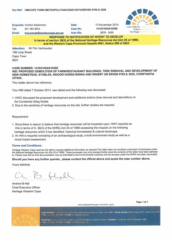
i

TABLE OF CONTENTS

1.    Introduction and Project Description

2.    Statutory Framework

      2.1    Background
      2.2    Current application

3.    Scope of Work & Methodology

4.    Policy context

     4.1     City of Cape Town: Southern District Spatial Development Plan
     4.2     Constantia-Tokai Valley Local Growth Management and Development Plan
     4.3     Tangible Heritage Resources in the Constantia-Tokai Valley - Conservation
             Management Plan for this portion of the Cape Winelands Cultural Landscape

5.    Site Description and Environment

6.    Historical Background and Evolution of Development

7.    Identification of Heritage Resources and Statement of Significance

      7.1    Criteria for significance
      7.2    Regional scale: Cultural landscape context
      7.3    The farm scale
      7.4    Precincts and buildings
      7.5    Tree survey

8.    Heritage Indicators and Design Informants

      8.1    General principles
      8.2    Farm-specific heritage indicators
      8.3    Visual Indicators

9.    Conclusion and Recommendations

References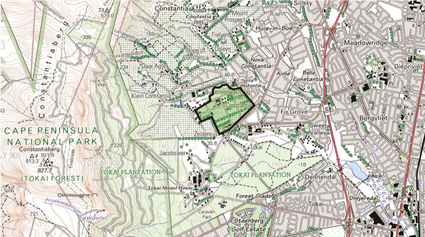
ii

LIST OF FIGURES

Cover page   Extract from 1932 Trigonometrical Survey Map
Figure 1     Locality Plan
Figure 2     Constantia-Tokai component of the SAHRA Grade 1 heritage site
Figure 3     2012 aerial photograph of Constantia Uitsig and surrounds
Figure 4     1880 survey diagram of the original farm Plumstead
Figure 5     Extract from 1901 Divisional Map of the Cape
Figure 6     Extract from 1931 Surveyor-General’s Map
Figure 7     1926 aerial photograph of the Constantia View werf
Figure 8     1945 aerial photograph of the Constantia Uitsig werf
Figure 9     1978 topographical plan of the Constantia Uitsig werf
Figure 10    2012 aerial photograph of Constantia Uitsig werf & naming of parts
Figure 11    The 1980s stable block
Figure 12    La Colombe Restaurant
Figure 13    Interior of the former River Café in the old school building
Figure 14    The Buitenverwachting homestead
Figure 15    The Nova Constantia homestead
Figure 16    The main entrance to Uitsig from Spaanschemat River Road
Figure 17    The entrance precinct from beyond the old school building
Figure 18    The vineyards of Uitsig from Nova Constantia Road
Figure 19    The Uitsig werf from the Buitenverwachting entrance road
Figure 20    The 1990s cricket oval at Uitsig
Figure 21    View across the river towards Buitenverwachting
Figure 22    The Tokai Primary School building from Spaanschemat River Road
Figure 23    The Tokai Primary School building from the main entrance
Figure 24    Long workers’ cottages along Spaanschemat River Road
Figure 25    Workers’ cottages along Spaanschemat River Road
Figure 26    The Lategan family cemetery
Figure 27    Close-up view of the graves in the Lategan family cemetery
Figure 28    The historic avenue of Marri Trees
Figure 29    The historic avenue of Karri Trees along Nova Constantia Road
Figure 30    Front elevation of the Lategan Homestead
Figure 31    The conservatory and terrace at the Lategan homestead
Figure 32    A rear gable of the homestead
Figure 33    The front stoep of the homestead
Figure 34    Interior of the conservatory at the homestead
iii

Figure 35    Interior of the homestead
Figure 36    The front garden and werf wall
Figure 37    The reception building and slave bell
Figure 38    The former hanepoot cellar (now a guest cottage) from the east
Figure 39    The former hanepoot cellar from the west
Figure 40    The 1951 entrance gates at the corner of Spaanschemat River and Nova
             Constantia Roads
Figure 41    Figure ground study of werfs in the Constantia-Tokai Valley
Figure 42    Heritage Indicators

LIST OF ANNEXURES

Annexure A   NID Response from Heritage Western Cape

Annexure B   Tree Survey by Planning Partners

Annexure C   Archaeological Report on plaster sampling at the Lategan Homestead by
             ACO Associates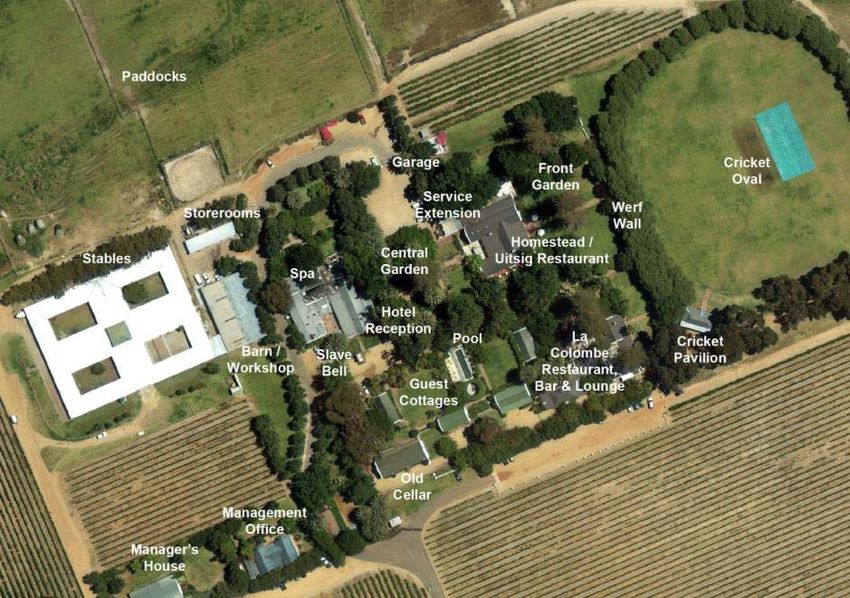
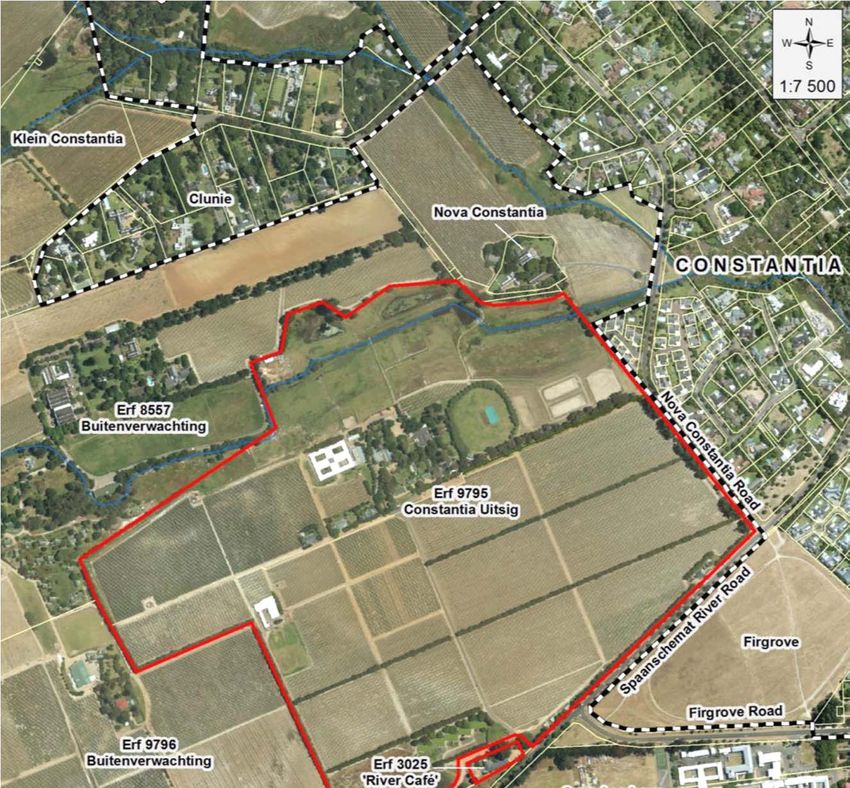
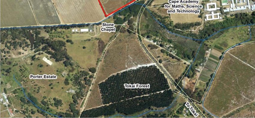
1

1.        Introduction and Project Description

Constantia Uitsig is a wine estate in the Constantia Valley in the Western Cape. It consists
of the remainder of Erf 9795 Constantia, which is 59,8ha in extent and is the principal farm,
as well as Erf 3025 Constantia, which is 3 040m² in extent and which accommodates the
former Tokai Primary School building, more recently used as a restaurant, known as the
River Café. Uitsig is accessed off Spaanschemat River Road, a scenic route which runs
along the south-eastern boundary.            The farm is bordered by the wine farm
Buitenverwachting on its western and north-western side, while the farmstead of Nova
Constantia, a Provincial Heritage Site, is located to the north-east. A number of other
historic wine farms, including Groot Constantia, Klein Constantia and Hope of Constantia are
located further north. On the eastern side are the residential suburbs of Nova Constantia
and Firgrove and further away are the suburbs of Sweet Valley and Belle Constantia. To the
south is Tokai Forest, including Porter Estate (see Figure 1 below).

None of the buildings on the farm are of great age or exceptional architectural significance,
but due to its location within the Cape Winelands Cultural Landscape, which is on
UNESCO’s Tentative List of World Heritage Sites and a Grade I Heritage Site, as well as its
historical association as a portion of Simon van der Stel’s estate, ‘Constantia’, it is of
considerable contextual and historical significance.

The farm currently accommodates ±30ha of vineyards and produces a range of wines under
its own label, but since the late 1980s, wine has not been made on the estate, but at the
winery on Steenberg estate. At the centre of Uitsig is a farmstead, which until recently used
to accommodate a hotel, health spa, conference facility, stables, a cricket oval with pavilion
and two restaurants (in addition to the above-mentioned River Café at the entrance). In
2014, both Erf 9795 and Erf 3025 were purchased by Pieter and Anthea Erasmus, who wish
to make Uitsig a private home for their family and use the farm for wine-making and
equestrian purposes. A replacement bar fence has recently been erected and a new
homestead, winery, stables and new indoor and outdoor arenas are planned. The vineyards
will be replaced on a phased basis and extensive landscaping and rationalisation of trees
and buildings will be required, especially in the werf precinct.

Figure 1: Locality Plan, with Constantia Uitsig outlined in black. To the north and east is Constantia, to the south is Tokai and
to the west, beyond Buitenverwachting, is Table Mountain National Park (Source: Chief Directorate Surveys and Mapping)
2

2.      Statutory Framework

2.1     Background

The subject site falls within the Cape
Winelands Cultural Landscape, a Grade I
heritage site, which has been identified by
the Council of the South African Heritage
Resources Agency (SAHRA) in 2006. See
Figure 2 on the right.

This Grade I site has not been formally
declared as a National Heritage Site in
terms of Section 27 of the NHRA, but as an
interim measure, a Memorandum of
Agreement regarding Grade I sites has
been signed between SAHRA and Heritage
Western Cape (HWC), in terms of which
SAHRA is a commenting body and HWC is
the approving authority for applications.

During 2014 and early 2015, prior to this
HIA, a number of ad hoc heritage
applications have been made to Heritage
Western Cape in order undertake
demolitions, urgent    renovations   and
security measures.

On 30 May 2014, a Notification of Intent to
Develop (NID) was submitted to HWC in Figure 2: The Constantia-Tokai component of the Cape
terms of Section 38(1)(a) of the National Winelands Grade I heritage site is indicated in green and
Heritage Resources Act for the erection of a Uitsig in red. (Source: Todeschini & Blanckenberg, 2006)
replacement bar fence around the property,
i.e. a “linear development or barrier exceeding 300m in length” (HWC Case No.
14042508AS0509E). On 13 June HWC responded that since there was no reason to
believe that heritage resources would be affected by the proposed fence, no further
processes under Section 38 were required for this activity. Building plans for the fence were
then approved by the City of Cape Town and the replacement fence was erected.

On 11 September 2014, an NHRA Section 34 permit application was submitted for the
demolition of two freestanding ablution blocks at the River Café, which were built c1918 and
were older than 60 years (HWC Case No. 14090213KB0911E). Comments were obtained
from the City of Cape Town’s Heritage Resources Section (HRS), SAHRA and the
Constantia Property Owners’ Association (CPOA). On 30 September 2014, this application
was approved by HWC and a permit issued.

On 9 October 2014, building plans by Inhouse Brand Architects and an NHRA Section 34
permit application were submitted for minor internal alterations to the River Café building for
the new restaurant operator (HWC Case No. 14093007KB1009E). Again comments were
obtained from the City’s HRS, SAHRA and the CPOA. On 22 October 2014, this application
was approved by HWC and a permit issued.

In early 2015, it became apparent that the existing underground sewer pipeline along the
river across Constantia Uitsig, from Buitenverwachting to Nova Constantia suburb, was in
urgent need of replacement and hence, on 24 March 2015, a separate NID was submitted to
3

HWC in terms of Section 38(1)(a) of the NHRA for this activity, i.e. “linear development
exceeding 300m in length” (HWC Case No. 15031910GT0325E). On 15 May 2015 HWC
responded that since there is no reason to believe that the proposed development will
impact on heritage resources, further processes under Section 38 of the NHRA do not apply
as far as the sewer pipeline is concerned.

On 31 March 2015 ACO Associates submitted a NHRA Section 34 permit application to
HWC for plaster stripping and sampling at the Lategan Homestead, in order to assess its
brickwork and establish its age and evolution over time (HWC Case No. 150325AS0331E).
On 30 September 2014, this application was approved by HWC and a permit issued. The
plaster sampling was undertaken on 22 May 2015 and the findings are contained in the
attached archaeological report.

2.2    Current Application

The proposed demolitions, new development and landscaping trigger Section 38(1)(c)(i) of
the NHRA, as it will “change the character of a site exceeding 5 000m² in extent”. A NID
was submitted to HWC on 29 October 2014 (HWC Case No. 14102105AS1029E) and on
13 November 2014, HWC issued a response, requiring that a Heritage Impact Assessment
(HIA), consisting of an archaeological study, a built environment study and visual impact
assessment, be submitted.

Section 38(3) of the NHRA requires that the following information must be included in an
HIA:
“(a)   The identification and mapping of all heritage resources in the area affected;
(b)    An assessment of the significance of such resources in terms of the heritage
       assessment criteria set out in section 6(2) or prescribed under section 7;
(c)    an assessment of the impact of the development on such heritage resources;
(d)    an evaluation of the impact on the development on heritage resources relative to the
       sustainable social and economic benefits to be derived from the development;
 (e)   the results of consultation with communities affected by the proposed development
       and other interested parties regarding the impact of the development on heritage
       resources;
 (f)   if heritage resources will be adversely affected by the proposed development, the
       consideration of alternatives; and
 (g)   plans for mitigation of any adverse effects during and after the completion of the
       proposed development.”

This report is the first phase of an HIA submitted to HWC to comply with the
requirements of Section 38(3) and in order to obtain a decision in terms of Section
38(4) of the NHRA. No process in terms of the National Environmental Management Act
(NEMA) is required for the proposed development.
4
3. Scope of Work & Methodology
This Phase 1 HIA report has been prepared in partial fulfilment of the requirements of
Section 38(3) of the NHRA and to meet the requirements of HWC’s response to the NID that
was submitted.
Not much has previously been written on the history of Uitsig, except for passing references
contained in literature about its parent farm, Buitenverwachting. A number of primary
sources therefore had to be consulted, including:
the cadastral records of the Surveyor General,
transfer records of the Registrar of Deeds,
aerial photographs of the Chief Directorate: Surveys and Mapping,
historic maps of the City of Cape Town’s Environmental and Heritage Resources
Information Centre,
approved building plans obtained from the City of Cape Town’s Building
Development Management Section and
estate papers, death notices, building reports and wills at the Cape Archives.
Several site visits were undertaken and a number of individuals were also interviewed.
During the Phase 2 HIA process, comments will be obtained from the City of Cape Town’s
HRS, SAHRA and the CPOA and their comments were incorporated into the findings and
recommendations of the final HIA report.
The project team for this phase of the study comprises:
Principal Architects for Constantia Uitsig: Bouwer Architects
Tree Survey and Landscape Architects: Planning Partners
Visual Impact Assessors: Quinton Lawson and Bernard Oberholzer
Archaeologists: ACO Associates
Heritage Practitioner: Frik Vermeulen
5

4           Policy context

The following policy documents are applicable to the subject site:

4.1         City of Cape Town: Southern District Spatial Development Plan (2012)

The Southern District SDP flows out of the over-arching Cape Town Spatial Development
Framework and gives effect to its key spatial strategies at a district scale. Within the
Constantia Winelands Cultural Landscape, development that is considered undesirable
includes “sub-division and densification, high density residential or commercial, any
alterations, additions or new structures unsympathetic to protected buildings or the general
character of the area and inappropriate outdoor advertising”1.

Within Sub-district 2, it is proposed to:
(a) “Protect the integrity of the urban edge by restricting encroachment;
(b) Support viticulture production through restricting fragmentation and encouraging
    consolidation, and where possible expanding agricultural development; and
(c) The character of these urban areas should in general not be subject to change. This
    includes the maintenance of cultural landscapes.”2

Constantia Uitsig is located outside the urban edge and is earmarked for “intensive
agriculture”. Spaanschemat River Road is classified as a Scenic Route3.

4.2         Constantia-Tokai Valley Local Growth Management and Development Plan,
            MLH Architects & Planners, Fabio Todeschini, Barrie Gasson, Piet Louw, (1992)

The primary aims of the Growth Management Plan, which followed a 1991 Constantia-Tokai
Valley Conservation Study by Todeschini & Japha, were to protect the character of the
Constantia-Tokai Valley and to prevent further residential invasion into farmland. The
desired future character of the Constantia-Tokai Valley is described as qualities called
“ruralness” and “Capeness” which derive from a legacy of unique natural and cultural
landscapes, and interlocking role as a place of production, recreation, living and institutional
uses".4

In order to promote the viability of farming, it is proposed to permit “the diversification of
activities on the farms into fields having an authentic connection to farming in order to
broaden the financial base of the whole operation, e.g. farm stalls, restaurants and
accommodation” 5

As far as Uitsig is concerned, the old Tokai Primary School is recommended for inclusion in
the National Register, the shed and little cellar on the central farmstead are considered as
“Pre-1915 structures of historical interest”, the main homestead is considered as a “Pre-1940
structure of historical interest” and the labourers cottages are classified as “Structures that
contribute to the character of the valley”.

1
    City of Cape Town, 2012, p80
2
  Ibid, p122-123
3
  Note that this road is not a designated Scenic Route i.t.o. the City of Cape Town Zoning Scheme, but has been identified in
the Scenic Drive Network Management Plan (2002) and subsequent
4
    MLH, Todeschini, Gasson, Louw, 1992, p43
5
    Ibid, p71
6

4.3   Tangible Heritage Resources in the Constantia-Tokai Valley - Conservation
      Management Plan for this portion of the Cape Winelands Cultural Landscape,
      Fabio Todeschini and Jean Blanckenberg (2006)

Uitsig is listed in the inventory schedule of heritage sites and buildings and the authors
recommend Grade 1 (National Heritage Site) grading for the farm, with particular mention of
the homestead and cellar, as part of the ‘Central Valley Farmland Area’ Grade 1 site.

The old Tokai Primary School is considered Grade 3A or 3B and recommended for inclusion
in the National Register. The labourers’ cottages along Spaanschemat River Road are
considered Grade 3C, which means that they have contextual significance and contribute to
the character of the area.

Following the above study, the Cape Winelands Cultural Landscape was nominated by the
Western Cape Government as a World Heritage Site and in 2007 it was placed on
UNESCO’s Tentative List of World Heritage Sites. This does not impact directly on the
current statutory process for development, but adds significance to the site and requires a
cautious approach when developing within this internationally-recognised heritage context.
7
5. Description of the site and environment
The subject site lies on the east-facing slopes of the Constantiaberg and comprises
approximately 60 hectares, of which approximately 30 hectares are under vine. About 50%
is currently irrigated, producing circa 140 tonnes of grapes of which approximately 30 tonnes
are sold to third parties.
The farm generally has a fairly even surface, with a gentle upward slope away from
Spaanschemat River Road, from south to north. The bulk of the improvements are located
on the central, most elevated portion of the property, with good mountain views and views
across the river. This werf consists of a homestead, a densely planted garden and farm
buildings, but is not a typical Cape ‘werf as discussed described later in this report. It does
however display some characteristics of a Cape werf, such as an orthogonal layout, axial
alignments, gabled buildings and large, mature trees, including English Oaks, but the
buildings are not arranged around an open, central square or linear space and the
homestead is not the main focal focal point within the werf. A mature avenue of Marri Trees
runs towards Nova Constantia Road, while an avenue of Karri Trees runs parallel to Nova
Constantia towards a secondary entrance on Spaanschemat River Road, marked with a
large, ornate gate. Large Norfolk Island Pines are also located in the central precinct, but all
of these are now senescent or pre-senescent. East-west windbreaks of Beefwood trees
between the vineyards and along the boundaries were introduced in c1989 and some of the
internal windbreaks have subsequently been removed.
The site used to accommodate three restaurants, of which two have now closed down, as
well as guest cottages and former hotel buildings, including a reception/function room (the
former dining hall), conference centre and spa. There are also management offices,
commercial stables, a wine shed, a workshop, garages, management housing, workers'
cottages and a cricket oval, which was previously used as a function venue.
Uitsig is one of the only six remaining historically significant farms that have survived in the
Cape Peninsula6. Together with the neighbouring farms of Buitenverwachting, Klein
Constantia and Groot Constantia, Uitsig constitutes the central agricultural anchor of the
Constantia-Tokai Valley. These farms all contribute to the rich cultural landscape of this
portion of the Cape Winelands Cultural Landscape.
6
Leibman, 2010, p158 Figure 3: 2012 aerial photograph of Constantia Uitsig (red outline) and surrounds. The Urban Edge is shown as a black and white line.
9

6.         Historical background and evolution of development

Constantia Uitsig is a relatively recent subdivision of a farm called ‘Plumstead’ (as
Buitenverwachting, Uitsig and Clunie were collectively known during the late 19thC and early
20thC) and is the result of a series of consolidations and subdivisions over time. Even
though Uitsig and its buildings are not as old as the other historically-linked farms in the
Constantia Valley, its origins can be traced back to 1685 when the farm ‘Constantia’, 891
morgen in extent, was granted to Governor Simon van der Stel by the Dutch East India
Company. After the death of Van der Stel in 1712, his estate was divided into three portions
– ‘Groot Constantia’, ‘Klein Constantia’ and ‘Bergvliet’ – and these lots were sold in 1716.

In 1793, the owner of Bergvliet, Hendrik Oostwald Eksteen, sold nearly 200 morgen (almost
a third of his estate) to his brother-in-law, Cornelis Brink. In 1794 Cornelis Brink sold 172
morgen to his younger brother Arend Brink, who gave it the name ‘Buitenverwachting’ –
‘beyond expectation’. The remaining 28 morgen of Cornelis Brink’s estate became Nova
Constantia 7. In 1796, Arend Brink built an elegant homestead on Buitenverwachting8, but
he did not remain on it for long, as in 1797, he sold it to Ryk Arnoldus Mauritius Cloete, the
younger brother of Hendrik Cloete, their neighbour at Groot Constantia9.

Ryk Cloete changed the farm’s name to ‘Cis-Constantia’ and invested a large amount of
money in his estate, particularly in the purchase of slaves. When slavery was abolished at
the Cape in 1834, he lost heavily and as a result was declared bankrupt in 1836. Before that
time however, in 1827, Ryk had already tried to cut his losses by selling Cis-Constantia to
his nephew Pieter Lourens Cloete Jnr.

In 1832, Pieter Cloete sold Cis-Constantia to his younger brother Johan Gerhard Cloete. By
1852 Johan Cloete was also bankrupt and in 1852, the estate was bought from the insolvent
estate by the wealthy businessman Abraham de Smidt, who also owned Westbrooke and
Groote Schuur in Rondebosch.

One year later, in 1853, De Schmidt sold the farm to Jacob William Brunt. Brunt, his wife,
Suzanne Margaretha de Villiers and their nine children moved to Cis-Constantia, which
shared a common boundary with his brother's farm, Klein Constantia. He immediately
renamed it ‘Plumstead’ 10 (not to be confused with the nearby suburb of Plumstead). After
having another two children, Jacob Brunt died suddenly in 1856 and his widow continued to
farm the estate until 1866, when she sold it to Michiel Adriaan Siebritz. He however died
since the sale and his estate immediately transferred it to Johannes Wynand Louw, who
renamed it back to Buitenverwachting 11.

When Johannes Louw bought Buitenverwachting, he re-united the farm, which Comelis
Brink had bought from Hendrik Eksteen. Louw and his wife, who were living at the
neighbouring Nova Constantia, had managed to retain some of their vineyards and
continued to produce wine, but his other farm, Buitenverwachting was in poor condition and
had become a drain on his finances. In 1880 Louw subdivided his estate, as shown on the
survey diagram for the 225 morgen estate Plumstead below, which excluded Nova
Constantia. In 1881 he sold the largest portion (179 morgen), which was largely comprised
of Buitenverwaching, to Stephanus Petrus Lategan for £4 00012.

7
    Brooke Simons, 2000, p67
8
    Fransen, 2004, p148
9
    Robinson, 2014, p79
10
     Robinson, 2014, pp139-140
11
   The name Plumstead however remained in use for a considerable time thereafter, as can be seen on the 1931 survey map
   (Figure 7)
12
   Deed of Transfer T379/1881
10 Figure 4: Survey diagram 187 of 16 December 1880 for the farm ‘Plumstead’, later known as Erf 2992 Constantia. The farmyard buildings of Buitenverwachting can be seen at the centre of the estate, to the north of the river, but the Uitsig werf to the south-east thereof was not developed at the time. (Source: Chief Surveyor-General’s Office)
11

Stephanus Petrus Lategan (1831-1900) was an affluent farmer from Wellington. The
Lategan family is of German origin, their progenitor Johann Herman, having come from
Westphalia to the Cape in 1736, to commence farming at Drakenstein.13 SP Lategan pulled
out the diseased vines on the farm, planting instead the deciduous fruit trees which were
grown so successfully by his family on farms in the Wellington and Worcester areas.14

In 1882 Johannes Wynand Louw sold the remaining 45 morgen of Erf 2992 (the portion that
is now the core of Constantia Uitsig) to Martina Jacoba Brunt, who was married to the son of
the late Jacob Brunt. Within three years, she however went bankrupt and in 1885 she sold
her portion to SP Lategan and Plumstead was re-united once again.

In 1894 SP Lategan sold the 45 morgen that he purchased in 1885 to his son Willem
Hendrik Lategan (1865-1940), who had been farming with his father since he left school.
Helen Robinson notes that this land had been leased to the army units stationed at Wynberg
for manoeuvres which had reduced it to a barren wasteland. Willem married Antoinette
Bredell, and with her inheritance built the present homestead on the estate and surrounded it
with vineyards and fruit trees. He raised a family on his farm, which he named ‘Constantia
View’ 15. From there he began exporting wine and fruit to Europe very successfully.16

Since there was no earlier farmyard on Uitsig than the current late-19th C werf, the ‘slave
bell’ there does not date to the time of slavery, but to the early 20th C, approximately 1910.

Figure 5: Divisional map of the Cape, dated 1901, showing the property boundaries at the time, with the farm Plumstead as an
undivided estate. The farmyard buildings of Buitenverwachting can be seen at the centre of the estate. (Source: Chief
Surveyor-General’s Office, courtesy of CoCT EHRIC)

13
     Burman, 1979, p133
14
     Robinson, 2014, p159
15
     Robinson, 2014, p165
16
     Burman, 1979, p137
12
Stephanus Petrus Lategan died at his residence, the Buitenverwachting homestead on
4 February 1900 and was buried in the cemetery of the Dutch Reformed Church in Wynberg.
He was survived by his wife, Sarah Lategan 17. After his death, the portion of Plumstead not
owned by his son Willem, was divided between two of his other sons, with Lot A, being 57
morgen, transferred to Johannes Retief Lategan (1872-1938) and the remainder, being 122
morgen to Daniel Stephanus (‘Danie’) Lategan (1867-1946). Johannes Retief Lategan sold
his share to his brother Willem in 1902. Danie Lategan, sold off two portions of his
inheritance – Lot B to Abdol Majiet Mathew and Lot C (later known as Clunie) to his brother,
Andries Petrus Lategan (1858-1930)18 – but he still became insolvent. Willem Lategan then
bought the two alienated portions from their respective purchasers, and in 1909 bought the
balance of Buitenverwachting from the insolvent estate of Danie Lategan. Thus, the farm
was re-united, this time by Willem Lategan - with the difference that Constantia View was
now the principal farm.19
The original Tokai Primary School building, located at the entrance to Uitsig off
Spaanschemat River Road was completed in 1902, as the Educational Gazette of 1902
states that the school was opened at the start of the 3rd term of that year. It was a ‘3rd class
public undenominational school’ and in its first term, there were already 56 pupils, all of them
white.20 The original farm school was most likely a modest structure, built by the Lategans,
as the land on which it was situated remained in the family’s ownership for another 15 years.
In 1914, Willem Lategan subdivided the 61 morgen remainder of Buitenverwachting into two
portions and sold 32 morgen, including the historic farmstead back to his brother Danie
Lategan. Henceforth, Buitenverwachting and Constantia View would remain separate farms.
On 5 April 1917, the school property, which is now Erf 3025 Constantia was subdivided from
Lot A by Willem Lategan and sold to the Trustees of the Tokai Undenominational Public
School for the amount of £25021. Later in 1917, a new school building was built by the
Colonial Government. The architect was John Perry, who had worked in the office of James
Morris at the time and the contractor was J. James of Wynberg. The 1918 completion
certificate states that the building cost, excluding professional fees, was £3 585.22 According
to Sigrid Howes, the school was an Afrikaans medium school by the 1920s, called ‘Tokai
Primêre Skool’. By 1921 it had 137 pupils, all white. It is not known when the school was
opened to non-white children, but the establishment of new and better equipped ‘white
schools’ in the area in the 1950s - Bergvliet Primary School and Sweet Valley Primary
School - would have led to a reduction in the number of white children at Tokai Primêre
Skool and by the 1970s it was a ‘coloured’ school.
The existing Cape Revival homestead with twin gables in the north-eastern corner of the
Uitsig werf is 1920s stylistically, including its window and door finishes. Archaeological
investigations have revealed this to be a refurbishment of the original homestead that Willem
Lategan built in the mid-1890s and the original walls, approximately 500mm thick, have been
built from lightly fired homemade bricks and prepared mud/daga are still extant23. The
refurbished H-shaped building with a shiny new roof is clearly visible on the 1926 aerial
photograph (see Figure 7).
17
Death Notice, Cape Archives. MOOC 6/9/397/311
18
Andries Lategan also owned the neighbouring Nova Constantia
19
Burman, 1979, p137
20
Sigrid Howes, Centre for Conservation Education, personal communication; 18 June 2014
21
Deed of Transfer T2266/1917
22
Cape Archives. PAE 96/B2021
23
ACO Associates, 201513
The only other buildings that existed on the werf in 1926 are the shed on the western side of
the central garden, the ‘slave bell’ to the south thereof and the small, gabled wine cellar
further south. At the entrance to the farm, to the east of the school, were two labourers’
cottages on the south-eastern boundary (subsequently demolished and replaced).
For a considerable period, the estate was used for wine and fruit farming, until Willem
Lategan replaced the last orchards with vineyards in 193024, including the site that is now the
cricket oval. These vines are already annotated on the 1931 survey map (Figure 6) on the
previous page. Between 1926 and 1931 a large (±1 100mm²), gabled wine cellar was built
on the southern side of the main farmyard of Constantia View.
Willem Lategan died on 25 March 1940 and was survived by his wife Antoinette Jacoba
Carolina Lategan. He was the first of three generations of Lategans to be buried in the
family graveyard on the farm. In 1941 the four properties that constituted Constantia View
passed to his eldest son, Stephanus Petrus Lategan (1894-1968), who renamed it
‘Constantia Uitsig’, in accordance with his father’s wish. These four properties, shown on
Figure 6 above were:
(a) Constantia View, as per Deed of Transfer T6158/1894 (45 morgen in extent);
(b) the remainder of Lot A Plumstead, as per Deed of Transfer T7900/1902 (57 morgen);
(c) Constantia Berg, as per Deed of Transfer T1225/1907 (the 31 morgen) and
(d) Annex Constantia Berg, as per Deed of Transfer T3694/1914 (28 morgen).
In Willem Lategan’s estate papers, Constantia View is described to comprise “a large and
small residence, cellar, stable and outbuildings”. 25. Elsewhere in his will, he also refers to
various rooms in “the old dwelling house” on the estate, which supports the opinion that the
gabled Lategan homestead dates back further than the 1920s. The “small residence”, which
is referred to above would be the 1930s dwelling on Lot A, later referred to as ‘Bo-Uitsig’.
Stephanus Petrus Lategan was to make a successful career in politics and became a
senator. The Lategan family also owned the neighbouring farm, Nova Constantia. In 1931,
after the death of Andries Lategan, it was inherited by Robert (‘Bob’) Lategan and his
brother, Christoffel Francois (‘Kitto’) Lategan. In 1945, it was inherited by Andries Petrus
(‘Nap’) Lategan and his sister, Beatrice Maria, who later transferred her share to him.26
The entrance gate to Constantia Uitsig at the corner of Spaanschemat River and Nova
Constantia Roads was built in 1951 by Senator SP Lategan The ornate piers are clearly
copies of the Boshof Gate in Newlands. In 1957 and 1961 two long, rectangular labourers’
cottages were built along Spaanschemat River Road and by the 1970s, all the labourers’
cottages in that area had been replaced with new cottages, built further from the road.27
Senator SP Lategan died on 29 September 1968 and was survived by his wife, Angelina
Lategan. In 1970 Uitsig was transferred to his son, Willem Hendrik Lategan (1930-1983).
Willem farmed and made wine on Uitsig until his death on 13 February 1983. He was
survived by his wife Jane Lategan and was buried in the family cemetery. Only in 1987 was
the farm transferred to his son, Stephanus Petrus (‘Stephen’) Lategan.
24
Dane & Wallace, 1981, p108
25
Estate Papers – WH Lategan, Cape Archives MOOC 6/9/6116/68278
26
Burman, 1979, p132
27
None of the building footprints on the 1945 aerial photograph and 1978 Cape Divisional Council maps overlap.Figure 6: A 1931 survey map, showing the parent farm Plumstead, its subdivisions and surrounding context. North is at the top. The extent of Willem Hendrik Lategan’s landholdings is shown in a thick black outline (by the author). By this time the central werf of Constantia Uitsig comprised several buildings, including an L-shaped wine cellar on the western side of the werf. At the time, Buitenverwachting and Nova Constantia were also still owned by Lategans. (Source: Cape Town and Environs, Office of the Surveyor-General; courtesy of CoCT EHRIC)
14

Figure 7: A 1926 aerial photo of the ‘Constantia View’ werf, showing a shed on the left and homestead on the right in a
structured garden. To the east is an orchard, with vineyards to the north and south (Chief Directorate Surveys and Mapping).

Figure 8: A 1945 aerial photo of the ‘Constantia Uitsig’ werf, showing an H-shaped homestead and a large wine cellar to the
west of the werf. Vineyards are now discernible on all four sides, with no orchards remaining (Chief Directorate Surveys and
Mapping).
15

Figure 9: 1978 topographical plan of the Constantia Uitsig werf, showing the homestead, wine cellar and other agricultural
outbuildings (From Divisional Council of the Cape Sheet 5368A; courtesy of CoCT EHRIC)

By the mid-1980’s, following the death of Willem Lategan, the only productive vines on Uitsig
were a few hectares of Hanepoot table grapes. In 1986, the large wine cellar was converted
into farm stores and within the next two years, it was demolished. Wine farming was largely
abandoned and equestrian activities were introduced. In 1986, building plans were
approved for livery stables for 82 horses, a riding school and administrative offices. This
large stable block, located to the west of the farmyard, was completed in 1987. Eventually,
the estate stabled approximately 35 horses for fee paying private owners and third parties.

During the 1980s five large, institutional row houses for farm labourers were constricted near
the entrance of Uitsig, behind the old school building.

The Tokai Primary School closed in 1987, due to a decline in the number of learners. The
forced removals in terms of the Group Areas Act would have had a drastic effect on the
school.28 The last few learners were accommodated at Constantia Primary School nearby
and the three teachers were transferred to other schools.29

Also in 1987, Erf 8555 and the reminder of Erf 2992 were consolidated to form the 102ha
Erf 9795. Simultaneously however, the 43ha western portion, Erf 9796 (known as ‘Bo-
Uitsig’) was subdivided off and sold to Aussicht Holdings (Pty) Ltd. That property, together
with the adjacent 64ha Erf 8557, now constitute the ±107ha Buitenverwachting estate.

In 1988 David McCay purchased Uitsig (the 59ha remainder of Erf 9795) from Stephen
Lategan and registered it in the name of Constantia Uitsig Farms (Pty) Ltd. McCay re-
introduced viticulture, restored the existing buildings and built a number of new buildings.

28
     In 1961 Constantia was declared a White Group Area under the Group Areas Act
29
     Cape Archives KUS 4/58/7/2/1/E42.
16
Figure 10: A 2012 aerial photograph of the Constantia Uitsig werf, naming the uses as they were at the time. North is at the
top. (Source: City of Cape Town).
In 1989, McCay established a cricket oval to the east of the main werf and planted poplar
trees around it. This oval was used by international and local cricket teams for friendly
matches, as well as serving as a venue for food and wine shows and weddings. In 1990, a
Neo-Victorian sports pavilion by Michael Dall Architects was built next to the oval, and a new
pool room and changerooms were built in the south-eastern corner of the werf. Several new
guest cottages were constructed in 1990 and in 1992, a land use departure was granted by
the Constantia Valley Local Council for guest accommodation. The hotel consisted of 16
guest suites and a conference facility. Also in 1992, a temporary land use departure was
granted for a restaurant and in 1993, the main homestead was converted by Michael Dall
Architects into the 120-seat ‘Constantia Uitsig Restaurant’.30
Figure 11: View of the 1980s stable block from the south-west
30
City of Cape Town: Building plan applications17
In 1994, following an extensive period of disuse, the Tokai Primary School property,
Erf 3025, was purchased from the State by the Constantia Valley Local Council, who
intended to lease it out as a crèche/pre-primary school. That use did however not
materialise. Also in 1994, a former shed was rebuilt into a farm office and in 1995 and 1998,
two new managers’ houses were built to the east of the farm office by Michael Dall
Architects. In 1995, the early 20thC gabled outbuilding on the werf, was converted into the
hotel reception and conference room.
In 1996, the cottage, changeroom and lounge
in the south-eastern corner of the farmstead
were converted into a restaurant, known as
‘La Colombe’, a multi award-winning fine-
dining restaurant, including being voted the
top restaurant in South Africa, the top
restaurant in Africa and the Middle East and
number 12 in the world’s top 50 restaurants.
In 2001 the Tokai Primary School property
was sold to Constantia Uitsig Farms (Pty) Ltd
to become a one-stop wine shop for the wine
estates in the area 31 Soon thereafter, the Figure 12: The terrace of the former La Colombe restaurant,
prior to its closure
school building was converted by Michael
Dall Architects to accommodate a wine tasting/sales facility and a bistro restaurant, known
as the ‘River Café’.
In 2002, Uitsig (the remainder of Erf 9795)
was subdivided into two portions (Erven
13029 and 13030), but this subdivision was
never registered and has subsequently
lapsed.
In 2004 La Colombe restaurant was
increased in size from 70 seats to 110 seats,
with a separate function venue, ‘The Palm
Room’, being added. In 2007, the
‘Constantia Uitsig Spa’ opened. This facility,
accommodated in the northern end of the
Figure 13: Interior of the former River Café, prior to its hotel reception/function room, contained six
closure.
multipurpose treatment rooms. In 2008,
service extensions were added to the Constantia Uitsig Restaurant, including a scullery,
storerooms and cold rooms. Alterations and extensions were also made at the River Café.
In 2010, a land use application was submitted to the City of Cape Town for (a) the
amendment of the urban edge, (b) the rezoning of two portions to the east and west of the
werf and subdivision to accommodate 30 erven for single residential use, (c) rezoning of the
hotel, two restaurants and the spa to Commercial Zone, (d) the expansion of its existing
hotel from 16 to 28 guest suites, (e) the relocation of the existing stables, (f) a new
workshop, (g) a new manager’s house and (h) a new winery. In light of a large amount of
objections received against the application, particularly the proposed subdivision and
suburban houses, the above applications were withdrawn.
In 2013 Erf 9795 (Uitsig) and Erf 3025 (the River Café) were put on the market and in 2014
they were purchased by Pieter and Anthea Erasmus.
31
Henry Aikman, former planner at Constantia Valley Local Council, personal communication; 12 June 201418
7. Identification of Heritage Resources and Statement of Significance
7.1 Criteria for Significance
In terms of Section 3(2) of the NHRA, the national estate includes, “(a) places, buildings,
structures and equipment of cultural significance”…..”(c) historical settlements and
townscapes” and “(d) landscapes and natural features of cultural significance”.
Cultural significance is defined as “aesthetic, architectural, historical, scientific, social,
spiritual, linguistic or technological value or significance”
Section 3(3) of the NHRA and HWC’s Short Guide to and Policy Statement on Grading
include the following categories of significance:
a) Aesthetic value
Importance in exhibiting particular aesthetic characteristics valued by a community or
cultural group
Contribution to the aesthetic values of the setting demonstrated by a landmark quality
or having an impact on important vistas or otherwise contributing to the identified
aesthetic qualities of the cultural environs or the natural landscape within which it is
located.
b) Architectural value
Significant to architectural or design history or is the work of a major architect or
builder
Importance as an example of a building type, style or period
Possessing special features, fine details or workmanship
c) Historical value
Importance in the community or pattern of history (including in the evolution of
cultural landscapes and settlement patterns; association with events, developments
or cultural phases) or illustrates an historical period
Having a strong or special association with the life or work of a person, group or
organisation of importance in history
Having a strong or special association with a particular community or cultural group
for social, cultural or spiritual reasons;
Significance relating to the history of slavery
d) Social value
Association with economic, social or religious activity
Significance in public memory
In addition to the above, a possible checklist for evaluating the significance of cultural
landscapes 32 includes:
Landscape as a resource
The landscape should be a resource of national or regional importance in terms of rarity and
representivity
32
Baumann, Winter & Aikman, 2006 (after Rössler 1995 and Phillips 1995)19
Design quality
The landscape should represent a particular artistic or creative achievement or represent a
particular approach to landscape design
Scenic quality
The landscape should be of high scenic quality, with pleasing, dramatic or vivid patterns and
combinations of landscape features, and important aesthetic or intangible qualities
(vividness, intactness, unity)
Unspoilt character/authenticity/integrity
The landscape should be unspoilt, without visually intrusive urban, agricultural or industrial
development or infrastructure. It should thus reveal a degree of integrity and intactness
Sense of place
The landscape should have a distinctive and representative character, including topographic
and visual unity and harmony
Harmony with nature
The landscape should demonstrate a good example of the harmonious interaction between
people and nature, based on sustainable land use practices
Cultural tradition
The landscape should bear testimony to a cultural tradition which might have disappeared or
which illustrates a significant stage in history or which is a good example of traditional
human settlement or land use which is representative of a culture/s
Living traditions
The landscape should be directly and tangibly associated with events or living traditions with
ideas or with beliefs, with artistic and literary works of high significance
7.2 Regional Scale: Cultural Landscape Context
Constantia Uitsig is located within a Grade I cultural landscape.
“The Cape Winelands cultural landscape is the product of the interaction between a natural
landscape of great scenic beauty and biodiversity, and human activities and responses over
a long period. These interactions have created features and settlement patterns that are
equally celebrated for their beauty, richness and diversity. ….. The Cape Winelands has
played an important role in the cultural development, economy and evolution of the local
community and the nation, and is of local, provincial, national and international
significance.”33
The Constantia-Tokai Valley is highly representative of the Cape Winelands Cultural
Landscape in terms of the visual dominance of a productive agricultural landscape, dramatic
mountain-valley setting and collection of historical farm werfs.
33
Todeschini & Pistorius, 2004, in Todeschini, 2014, p520
It reflects a pattern of early colonial settlement and expansion during the late 17th and 18th
centuries with an emphasis on agricultural production concentrated in the well watered fertile
valleys. Constantia in particular has played a key role in the history of the wine industry has
a distinctive and legible pattern of agricultural settlement which has evolved in response to
fertile soils, water availability and movement routes.
The Cape Winelands reflect the history of farm labour, i.e. slavery, indentured labour, wage
labour and migrant labour. Its community has worked and inhabited the landscape for
generations resulting in strong linkages between place and social identity. 34
It is not only the vineyards, orchards and forested green spaces of the Constantia-Tokai,
Stellenbosch, Hottentots-Holland, Drakenstein, Dwars River Valley and Franschhoek regions
that contribute to the greater Cape Winelands cultural landscape, but also the distant views
of its farmstead settings, created by trees, werf walls and vernacular architecture.
Due to the high visibility of Uitsig’s farmstead from the north, across the river, it is important
that impact on views from significant farmsteads, such as Buitenverwachting (the former
heart of the estate of which Uitsig originally formed part) and Nova Constantia (a proclaimed
Provincial Heritage Site), be taken into consideration in the design of new development.
Figure 14: The Buitenverwachting homestead (1796), Figure 15: The Nova Constantia homestead (c1808), a
formerly the
7.2 principal
Site homesteadand
character of theheritage
Plumstead resources
estate. declared
at farm Provincial
scaleHeritage Site
7.3 Heritage Resources at the broad scale
Constantia Uitsig forms part of a historical core incorporating the farms of Groot Constantia,
Klein Constantia, Hope of Constantia, Buitenverwachting and Nova Constantia and the
Spaanschemat River Road scenic corridor
In the case of Constantia Uitsig, it is not individual buildings that are the most significant
heritage resources, but the collective contribution that its vineyards, historic trees and the
farmstead as a whole make to the greater Constantia-Tokai cultural landscape.
As a portion of Van der Stel’s original Constantia and later Bergvliet and Buitenverwachting,
Uitsig has some historical value in terms of its association with a pattern of early colonial
settlement dating to the late 17th century. It does however not have outstanding
architectural value, and demonstrates very few of the key design principles of the Cape farm
werf tradition, as represented by the earlier, grand set pieces of the Cape Winelands. Uitsig
does not display the same level of spatial cohesion, does not have a central square and the
homestead is not prominent when viewed from within the werf. It does however have an
orthogonal layout and contains some traditional elements, such as gabled buildings, werf
walls, some axial alignments and mature avenues of trees.
34
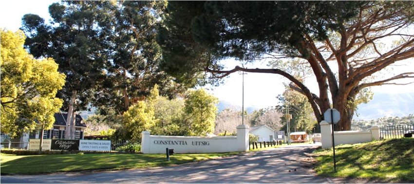
Baumann & Winter, 2014, p2821 Figure 16: A September 2014 photograph of the main entrance to Constantia Uitsig, with the River Café and wine shop on the left. Five utilitarian, 1980s workers’ houses, of which one is visible in the distance, have subsequently been demolished. Figure 17: A March 2015 photograph from beyond the River Café towards the west, with a cycling pump track in the distance on the left and the current security hut on the far right. The site beyond the lawn has been earmarked for a new winery. Figure 18: A photograph of the vineyards on Uitsig from Nova Constantia Road, with Tokai Forest and the Constantiaberg in the distance. The werf is located behind the avenue of Marri trees on the right.
22

Figure 19: View of the Uitsig werf, dominated by Norfolk Island Pines, from Buitenverwachting’s access road. The cricket
pavilion is on the far left, the werf wall of the front garden to the right thereof and the Lategan Homestead at the centre

Figure 20: View across the cricket oval to the north-east of the Uitsig werf, with the 1990 sports pavilion on the left, La
Colombe restaurant to the right thereof and the werf wall running in front of the garden from left to right.

Figure 21: View from the Uitsig werf towards the north-west, with its paddocks along the river and Buitenverwachting in the
distance.
23

The western portion of the farm, as viewed from Spaanschemat River Road, is characterised
by vineyards and windbreaks, even though the south-western vineyards have recently been
removed.

The existing buildings on the farm have relatively limited intrinsic heritage significance. It
does contain some structures older than 60 years, of which the Tokai Primary School
building has the most historical and architectural merit.

Uitsig also does not have a direct, significant association with a historic person, except that
this was once a portion of Van der Stel’s ‘Constantia’ and the fact that five generations of
Lategans, a prominent Cape family who once also owned the neigbouring farms
Buitenverwachting, Clunie and Nova Constantia, owned Uitsig.

The property is located in an historical rural landscape that is largely intact and of high
heritage significance in terms of historical value, architectural significance, with a high
concentration of conservation worthy farmsteads on historical farms that have withstood
development pressure and suburbanisation. The Grade I designation of the farm is
therefore supported.

7.4      Site scale: Precincts and buildings

To the left of the entrance to the estate, on Erf 3025 is the historic Tokai Primary School,
surrounded by large Gum trees.

                                                            This former Afrikaans medium, public
                                                            undenominational     school,   which     was
                                                            designed by prominent architect John Perry
                                                            (1874-1943 (FRIBA) and built by the Union
                                                            Government between 1917 and 1918. It
                                                            replaced an earlier farm school, built by the
                                                            Lategan family 1902.

                                                            As mentioned in Section 6 above, its closure
                                                            in 1987 was partly due to the establishment of
                                                            larger, better equipped schools in the Tokai
Figure 22: The former Tokai Primary School (1918), more     and Bergvliet area, but also the forced
recently known as the River Café, viewed from the south.    removals in terms of the Group Areas Act.

Even though much altered internally when converted into a restaurant, The River Café, in
the 1990s, this building retains many original features, including its public facades, hipped
roof typology and evenly-distributed, vertically-aligned timber windows. In addition to its
contextual significance as a landmark along
the Spaanschemat River Road scenic
route, it also has intrinsic architectural,
historical and social significance and serves
as a tangible reminder of Constantia and
Tokai’s more recent social history. It is
conservation-worthy and is considered to
be a Grade IIIB heritage resource. It is
important that its southern and eastern
facades, as viewed from the scenic route,
remain intact and uncluttered and the
building’s landmark status is not diminished
by new development or landscaping in the Figure 23: The main entrance to the River Café restaurant
                                                and wine shop from the parking area on the eastern side.
vicinity that would visually compete with it.
24
To the right of the main entrance of Uitsig and
along the southern property boundary are five
workers’ cottages, built in the late 1950s and
1960s, which replaced eight earlier, square
cottages, which were originally built closer to
the road. They are built with cement blocks
and have steel-framed windows. Some have
flat roofs and others have pitched roofs. In
2014, building plans were approved by the
City of Cape Town for the conversion of the
Figure 24: Long, pitched-roofed workers’ cottages, viewed
flat roof cottage closest to the main entrance
from Spaanschemat River Road, with the new replacement into a wine tasting and sales facility. The
fence in the foreground. . alterations were completed in January 2015.
Even though these mid-20th C cottages are of
low architectural and aesthetic significance,
they have considerable social and contextual
value, as examples of modest, mid-20th C
workers’ housing (now quite rare in
Constantia), are part of the history of history
of Constantia and are authentic elements of a
traditional working farm, contributing to the
Grade 1 cultural landscape. They are
conservation-worthy and are considered
Grade IIIC heritage resources. Figure 25: A flat-roofed workers’ cottage, viewed from within
the estate
Close to the western boundary of Uitsig, adjacent to the contemporary farm shed, is the
walled graveyard of the Lategan family, which contains the following graves:
a four-year old boy, Willem Hendrik Lategan (1906-1910),
Willem Hendrik Lategan (1865-1940),
his wife, Antoinette Jacoba Carolina Lategan (1874-1945),
(Senator) Stephanus Petrus Lategan (1894-1968),
his wife, Angelina Lategan (1900-1961);
Willem Hendrik Lategan (1930-1983).
This cemetery, which is now older than 100 years and is the final resting place of three
generations of Lategans, has historical significance and is considered Grade IIIA.
Figure 26: The walled Lategan family cemetery on the farm Figure 27: Close-up view of the gravestones in the family
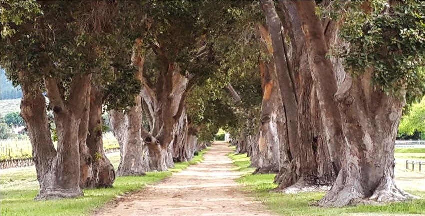
cemetery25 Figure 28: The historic avenue of Marri trees leading towards the werf from Nova Constantia Road, viewed from the east. Between the central werf and Nova Constantia Road is a mature avenue of Marri trees (Corymbia calophylla), which meets a mature avenue of Karri trees (Eucalyptus diversicolor), running parallel to Nova Constantia Road. The driveway is still a dirt road for its entire length, which retains the rural character of the farm, in contract with the suburban character of the road and residential neighbourhood to the west, which was established in the 1960s. The trees are in a good condition, are at least 100 years old and have historical, aesthetic and contextual value. They are conservation-worthy and are considered to be of Grade IIIC significance. Figure 29: View along Nova Constantia Road towards the south-east, with the historic avenue of flowering gum (Karri) trees on Uitsig on the right.
26

The most noteworthy building within the main werf is the H-shaped, Cape Revival
homestead, which has two gables facing the central garden and two gables facing the
cricket oval. The gables are slightly flattened versions of the historical ‘holbol’ (concave-
convex) gable.

The building, which has its origins as the Victorian homestead built by Willem Lategan in
c1894, has thick outer walls (some approximately 500mm in diameter), characteristic of pre-
20th C buildings, but stylistically, it has a 1920s appearance, also in its detailing and interior
woodwork. It has front and back stoeps and a corrugated iron roof.

As mentioned in Section 6, a plaster sampling investigation by archaeologists ACO
Associates, have confirmed this building to contain the original 1890s walls, built from lightly
fired homemade bricks and prepared mud. It is therefore the oldest building on the estate.

Figure 30: The front garden elevation of the Lategan             Figure 31: The intrusive 1993 conservatory addition and
homestead, built in c1894 and remodelled on the 1920s            restaurant terrace viewed from the north.

Figure 32: One of the gables of the rear elevation of the        Figure 33: The front stoep of the homestead, with typical
homestead, as remodelled on the 1920s                            1920s timberwork

Figure 34: Interior of the light-weight conservatory.            Figure 35: Interior of the homestead with a fireplace and
                                                                 typical 1920s timberwork
You can also read