Physically-Consistent Generative Adversarial Networks for Coastal Flood Visualization
←
→
Page content transcription
If your browser does not render page correctly, please read the page content below

(IN REVIEW)                                                                                                                                   1

                                                        Physically-Consistent Generative Adversarial Networks
                                                                    for Coastal Flood Visualization
                                                                   Björn Lütjens∗ , Brandon Leshchinskiy∗ , Christian Requena-Mesa∗ ,
                                                         Farrukh Chishtie∗ , Natalia Dı́az-Rodrı́guez∗ , Océane Boulais∗ , Aruna Sankaranarayanan∗ ,
                                                                  Aaron Piña, Yarin Gal, Chedy Raı̈ssi, Alexander Lavin, Dava Newman
arXiv:2104.04785v3 [cs.CV] 19 May 2021

                                            As climate change increases the intensity of natural disasters,
                                         society needs better tools for adaptation. Floods, for example,
                                         are the most frequent natural disaster, and better tools for
                                         flood risk communication could increase the support for flood-
                                         resilient infrastructure development. Our work aims to enable
                                         more visual communication of large-scale climate impacts via
                                         visualizing the output of coastal flood models as satellite imagery.
                                         We propose the first deep learning pipeline to ensure physical-
                                         consistency in synthetic visual satellite imagery. We advanced
                                         a state-of-the-art GAN called pix2pixHD, such that it produces
                                         imagery that is physically-consistent with the output of an expert-
                                         validated storm surge model (NOAA SLOSH). By evaluating
                                         the imagery relative to physics-based flood maps, we find that
                                         our proposed framework outperforms baseline models in both                     Fig. 1: The Earth Intelligence Engine generates physically-
                                         physical-consistency and photorealism. We envision our work to                 consistent satellite imagery of future coastal flood events to
                                         be the first step towards a global visualization of how climate
                                                                                                                        aid in climate communication. Explore more results in high-
                                         change shapes our landscape. Continuing on this path, we show
                                         that the proposed pipeline generalizes to visualize arctic sea ice             resolution at trillium.tech/eie.
                                         melt. We also publish a dataset of over 25k labelled image-pairs
                                         to study image-to-image translation in Earth observation 1 .
                                                                                                                                              I. I NTRODUCTION
                                                                                                                               ur climate changes, causing natural disasters to become
                                            Index Terms—Physics-Informed Neural Networks, Genera-
                                         tive Adversarial Networks, Synthetic Data Generation, Climate
                                         Change, Flood Inundation Models, Visualization.
                                                                                                                        O      more intense [1]. Floods are the most frequent weather-
                                                                                                                        related disaster [2] and already cost the U.S. 3.7 B USD per
                                                                                                                        year [3]; this damage is projected to grow over the next
                                                                                                                        decades [1]. Visualizations of climate impacts are widely used
                                                                                                                        by policy and decision makers to raise environmental aware-
                                                                                                                        ness and facilitate dialogue on long-term climate adaptation
                                                                                                                        decisions [4]. Current visualizations of coastal flood impacts,
                                            *indicates equal contribution. Manuscript received March 12, 2021. This     however, are limited to color-coded flood maps [5] or synthetic
                                         work has been submitted to the IEEE for possible publication. Copyright        street-view imagery [6], which do not convey city-wide flood
                                         may be transferred without notice, after which this version may no longer be
                                         accessible. Corresponding author: B. Lütjens; lutjens@mit.edu.                impacts in a compelling manner, as shown in Fig. 2 and [7].
                                            B. Lütjens, B. Leshchinskiy, and D. Newman are with the Human Sys-         Our work generates synthetic satellite imagery of future
                                         tems Laboratory, Department of Aeronautics and Astronatuics, Massachusetts     coastal floods, informed by the projections of expert-validated
                                         Institute of Technology, Cambridge, MA, USA.
                                            C. Requena-Mesa is with the Max Planck Institute for Biogeochemistry,       flood models, to enable a more engaging communication of
                                         Jena, DE.                                                                      city-wide flood risks to governmental offices.
                                            F. Chishtie is with the Spatial Informatics Group, Pleasanton, CA, USA.        Generative adversarial networks (GANs) have been used
                                            N. Dı́az-Rodrı́guez is with the Autonomous Systems and Robotics Lab,
                                         Inria Flowers, ENSTA Paris, Institut Polytechnique Paris, FR.                  to generate highly photorealistic imagery of faces [12], [13],
                                            O. Boulais is with the Responsive Environments Research Group, MIT          animals [14], [15], or even street-level flood imagery [10].
                                         Media Lab, Cambridge, MA, USA.                                                 Recent works, have adapted GANs to generate satellite im-
                                            A. Sankaranarayanan is with the Viral Communications Group, MIT Media
                                         Lab, Cambridge, MA, USA.                                                       agery [16], [17], [18], [19], [20]. Synthetic satellite imagery,
                                            A. Piña is with the National Aeronautics and Space Administration (NASA)   however, needs to be trustworthy [21]. While many approaches
                                         Headquarters, Washington, DC, USA.                                             exist to increase the trustworthiness of neural network-based
                                            Y. Gal is with Oxford Applied and Theoretical Machine Learning Group
                                         (OUTML), Oxford University, Oxford, Oxfordshire, UK.                           models, including interpretable networks [22], adversarial ro-
                                            C. Raı̈ssi is with Ubisoft, Singapore, SG.                                  bustness [23], [24], or ensemble predictions [25], [26], this
                                            A. Lavin is with Latent Sciences, New York, USA.                            work focuses on ensuring physical-consistency.
                                            1 Code        and        data      will      be      open-sourced      at
                                         gitlab.com/frontierdevelopmentlab/fdl-us-2020-earth-engine upon publication;      Many recent works incorporate domain knowledge from the
                                         an interactive demo is available at trillium.tech/eie.                         physical sciences into deep learning [27], [28], [29], [30]. Our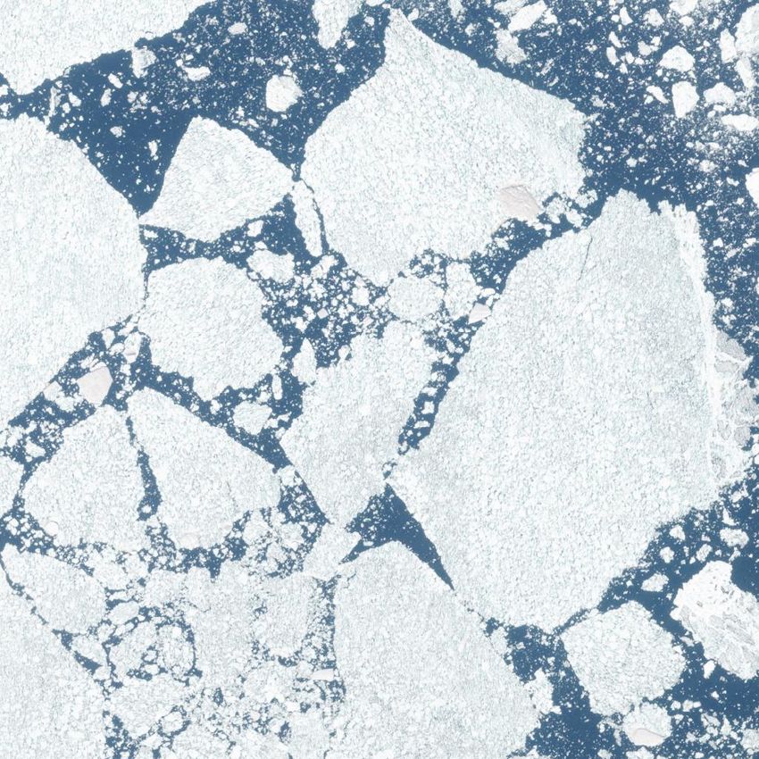
(IN REVIEW)                                                                                                                          2

              a) color-coded                             b) street view                              c) satellite (ours)
Fig. 2: Physically-consistent satellite imagery (c) could enable more engaging and relatable communication of city-scale
flood risks [4]. Most existing visualizations of coastal floods or sea-level rise that are aimed towards the public rely on
color-coded geospatial rasters (a), that can be unrelatable or impersonal [5], [8], [9]. Alternative photorealistic visualizations
are often limited to local street-level imagery (b) [6], [10] that lack further spatial context. Image sources: [5], [5], [6], [6],
[11], ours.

work aims to generate physically-consistent imagery, whereas        to-image translation [12]. Within image-to-image translation
we define an image as physically-consistent if it depicts the       models, generative adversarial networks (GANs) generated
same flood extent as an expert-validated coastal flood model,       samples of highly photorealistic imagery. For example, se-
as detailed in Section III-C. To achieve physical-consistency,      mantic image synthesis models generated photorealistic street
one could adapt the neural network architecture to incorpo-         scenery from semantic segmentation masks: DCGAN [43],
rate physics as: inputs [31], training loss [32], the learned       Pix2pixHD [13], DRPAN [44], SPADE [45], or OASIS [46].
representation [33], [34], [22], hard output constraints [35],      In comparison to GANs, normalizing flows [47], [26] or vari-
or evaluation function [36]. Alternatively, one could embed         ational autoencoders [48] capture the distribution of possible
the neural network in differential equations [37], for example,     image-to-image translations more accurately [49], but single
as: parameters [38], [32], dynamics [39], residual [40], [41],      samples often look less realistic ([50], [51], Fig. 4). Because
differential operator [27], [42], or solution [32]. Our work        our use case requires photorealism we focus on GANs and
is the first in leveraging any of these methods to ensure           extend the high-resolution semantic image synthesis model,
physical-consistency in synthetic visual satellite imagery, to      pix2pixHD [13], to take in physical information and produce
the extent of the authors’ knowledge. Specifically, our work        imagery that is both photorealistic and physically-consistent.
leverages years of scientific domain knowledge by incor-            We leave ensemble predictions capturing the full distribution
porating physics-based coastal flood model projections as           of images for future work.
neural network input and evaluation function. Exploring the
alternative forms of physical consistency for satellite imagery
                                                                     B. Physics-informed deep learning.
is an exciting field left for future works.
   Our work makes five contributions:                                  Physics-informed deep learning has recently generated sig-
   • the first generative vision pipeline to generate physically-   nificant excitement. It promises to increase trust, interpretabil-
     consistent visual satellite imagery for hypothetical scenar-   ity, and data-efficiency of deep learning models [27], [28],
     ios, called the Earth Intelligence Engine,                     [31]. The Earth Intelligence Engine incorporates a physics-
   • the first physically-consistent and photorealistic visual-     based coastal flood model as input and evaluation function
     ization of coastal flood models as satellite imagery,          and is the first in the physics-informed deep learning literature
   • a novel metric, the Flood Visualization Plausibility Score     to generate physically-consistent satellite imagery [31]. Future
     (FVPS), to evaluate the photorealism and physical-             works will extend the connections between physics and deep
     consistency of generated imagery, and                          learning-generated satellite imagery. For example, [52] could
   • the demonstration of a climate impact visualization            be used to learn a physically-interpretable latent space, e.g., a
     pipeline on coastal floods and melting Arctic sea ice,         “flood neuron“, [53] to embed deep learning in atmospheric
   • an open-source dataset with over 25k labelled high-            noise models, or [46] to incorporate physics-based flood maps
     resolution image-pairs to study image-to-image transla-        in the loss function.
     tion in Earth observation.
                                                                     C. Climate change visualization tools
                     II. R ELATED W ORK
                                                                       Visualizations of climate change are commonly used in
   Our work combines a coastal flood model with a generative        policy making and community discussions on climate adap-
vision model in a novel physically-consistent pipeline to create    tation [4], [54]. Landscape visualizations are used to raise
visualizations of coastal floods.                                   environmental awareness in the general public or policy [7],
                                                                    [10], because they can convey the impacts of climate change,
 A. Generative vision modeling.                                     such as rising sea levels or coastal floods, in a compelling and
  We aim to learn the change in satellite imagery from before       engaging manner ( [7], Fig. 2b). Most landscape visualizations,
to after a coastal flood, which is similar to paired image-         however, are limited to regional information [6]. Additionally,
(IN REVIEW)                                                                                                                            3

most landscape visualizations require expensive physics-based
renderings and/or high-resolution digital elevation models [6].     Pre-flood sat. img.
Alternative visualization tools of coastal floods or sea-level                                            Post-flood satellite image
rise are color-coded maps, such as [55], [5], [9]. Color-coded
maps convey the flood extent on a city-wide scale, but are less
engaging than a photorealistic image [4]. We are generating
                                                                                            GAN
compelling visualizations of future coastal floods as satellite         Flood map
imagery to aid in policy and community discussion on climate
adaptation.

                       III. A PPROACH
  The proposed pipeline uses a generative vision model to
generate post-flood images from pre-flood images and a flood       Fig. 3: Model Architecture. Our model leverages the semantic
extent map, as shown in Fig. 3.                                    image synthesis model, Pix2pixHD [58], and combines a
                                                                   pre-flood satellite image with a physics-based flood map to
                                                                   generate post-flood satellite imagery.
 A. Data Overview.
   Obtaining ground-truth post-flood images that display stand-
ing water is challenging due to cloud-cover, time of standing      Pix2pixHD is a state-of-the-art semantic image synthesis
flood, satellite revisit rate, increased atmospheric noise, and    model that uses multi-scale generator and discriminator archi-
cost of high-resolution imagery. This work leverages the xBD       tectures to generate high-resolution imagery. We extended the
dataset [11], a collection of pre- and post-disaster images from   input dimensions to 1024×1024×4 to incorporate the flood
events like Hurricane Harvey or Florence, from which we ob-        extent map. The resulting pipeline is modular, such that it can
tained ∼3 k pre- and post-flood image pairs with the following     be repurposed for visualizing other climate impacts.
characteristics: ∼.5 m/px, RGB, 1024×1024 px/img, Maxar
DigitalGlobe.                                                       C. Physically-consistent image.
   The coastal flood model is the Sea, Lake and Overland              We define a physically-consistent model as one that fulfills
Surges from Hurricanes (SLOSH) model [56], developed               laws of physics, such as, conservation of momentum, mass,
by the National Weather Service (NWS). SLOSH estimates             and energy [28]. For example, most coastal flood models
storm surge heights from atmospheric pressure, hurricane size,     consist of numerical solvers that resolve the conservation
forward speed, and track data, which are used as a wind            equations to generate flood extent predictions [56]. Here, we
model driving the storm surge. The SLOSH model consists of         consider an image to be physically-consistent if it depicts the
shallow water equations, which consider unique geographic          predictions of a physically-consistent model.
locations, features, and geometries. The model is run in              Specifically, we define our generated satellite imagery,
deterministic, probabilistic, and composite modes by various       IG ∈ I = [0, 1]w×h×c with width, w = 1024, height,
agencies for different purposes, including NOAA, National          h = 1024, and number of channels, c = 3, to be physically-
Hurricane Center (NHC) and NWS. We use outputs from                consistent if it depicts the same flood extent as the binary
the composite approach – that is, running the model several        flood map, F ∈ F = {0; 1}w×h . We implemented a flood
thousand times with hypothetical hurricanes under different        segmentation model, mseg : I → F, to measure the depicted
storm conditions. As a result, we obtain a binary flood hazard     flood extent in the generated image. If the flood extent of a
map from [5] as displayed in Fig. 2a which are storm-surge,        generated image and the coastal flood model match within a
height-differentiated, flood extents at 30 m/px resolution. The    margin, the image is in the set of physically-consistent images,
flood hazard maps do not intersect with the locations of           i.e,. Iphys ∈ Iphys = {IG ∈ I : IoU (mseg (IG ), F ) < }.
existing post-flood imagery. To get around the data limitation,    The generated image is considered photorealistic, if it is
we generate and coarse-grain segmentation maps of the post-        contained in the manifold of naturally possible satellite im-
flood imagery to 30 m/px for training and evaluation and           ages, Iphoto ∈ Iphoto ⊂ I. Hence, we are looking for a
use binarized flood hazard maps during test. Future works          conditional image generation function, g, that generates an
will extend the state-of-the-art ADvanced CIRCulation model        image that is both, physically-consistent and photorealistic, i.e,
(ADCIRC) [57] model, which is described in [8] and has a           g : Iphoto × F → Iphoto ∩ Iphys . Here, we condition the GAN
stronger physical foundation with better accuracy, and higher      on the flood map, F , and use a custom evaluation function to
resolution than SLOSH.                                             identify the generation function, g.

 B. Model architecture.                                              D. The Evaluation Metric Flood Visualization Plausibility
   The central model of our pipeline is a generative vision        Score (FVPS).
model that learns the physically-conditioned image-to-image           Evaluating imagery generated by a GAN is difficult [59],
transformation from pre-flood image to post-flood image. We        [60]. Most evaluation metrics measure photorealism or sample
leveraged the existing implementation of pix2pixHD [13].           diversity [60], but not physical consistency [61] (see, e.g.,
(IN REVIEW)                                                                                                                                 4

  a) pre-flood input   b) Flood mask input   c) ground-truth   d) physics-informed   e) GAN w/o     f) physics-informed   g) hand-crafted
                                             output            GAN (ours)            physics        VAEGAN
Fig. 4: The proposed physics-informed GAN, (d), generates photorealistic and physically-consistent flood imagery from
the inputs, (a,b), outperforming all other models, (e,f,g). The baseline GAN, pix2pixHD [13] (e), in comparison, receives
only a pre-flood image and no physical input. The resulting image, (e), is fully-flooded, rendering the model untrustworthy.
The VAEGAN, BicycleGAN [51] (f), creates glitchy imagery (zoom in). A handcrafted baseline model (g), as used in common
visualization tools [9], [55], visualizes the correct flood extent, but is pixelated and lacks photorealism.

SSIM [62], MMD [63], IS [64], MS [65] , FID [66], [67],                   over the test set further confirms it (see Section A for test
or LPIPS [68]).                                                           set details). Despite the photorealism ( LPIPS = 0.293), the
   To evaluate physical consistency we propose using the                  physical-inconsistency renders the model non-trustworthy for
intersection over union (IoU) between water in the generated              critical decision making, as confirmed by the low FVPS of
imagery and water in the flood extent map. This method relies             0.275. The model is the default pix2pixHD [13], which only
on flood masks, but because there are no publicly available               uses the pre-flood image and no flood mask as input.
flood segmentation models for Maxar RGB satellite imagery,                    2) A handcrafted baseline model generates physically-
we trained our own model on ∼100 hand-labeled flooding                    consistent but not photorealistic imagery.
images (Section IV-B). This segmentation model produced                      Similar to common flood visualization tools [9], the hand-
flood masks of the generated and ground-truth flood image                 crafted model overlays the flood mask input as a hand-
which allowed us to measure the overlap of water in between               picked flood brown (#998d6f) onto the pre-flood image, as
both. When the flood masks overlap perfectly, the IoU is 1;               shown in Fig. 4g. Because typical storm surge models output
when they are completely disjoint, the IoU is 0.                          flood masks at low resolution (30m/px [5]), the handcrafted
   To evaluate photorealism, we used the state-of-the-art per-            baseline generates pixelated, non-photorealistic imagery. Com-
ceptual similarity metric Learned Perceptual Image Patch                  bining the high IoU of 0.361 and the poor LPIPS of 0.415,
Similarity (LPIPS) [68]. LPIPS computes the feature vectors               yields a low FVPS score of 0.359, highlighting the difference
(of an ImageNet-pretrained AlexNet CNN architecture) of the               to the physics-informed GAN in a single metric.
generated and ground-truth tile and returns the mean-squared                  3) The proposed physics-informed GAN generates
error between the feature vectors (best LPIPS is 0, worst is              physically-consistent and photorealistic imagery.
1).                                                                          To create the physics-informed GAN, we trained
   Because the joint optimization over two metrics poses a                pix2pixHD [13] from scratch on our dataset (200 epochs
challenging hyperparameter optimization problem, we propose               in ∼7 hrs on 8× V100 Google Cloud GPUs). This model
to combine the evaluation of physical consistency (IoU) and               successfully learned how to convert a pre-flood image and a
photorealism (LPIPS) in a new metric (FVPS), called Flood                 flood mask into a photorealistic post-flood image, as shown
Visualization Plausibility Score (FVPS). The FVPS is the                  in Fig. 1. The model outperformed all other models in IoU
harmonic mean over the submetrics, IoU and (1−LPIPS), that                (0.553), LPIPS (0.263), and FVPS (0.532) (Table I). The
are both [0, 1]-bounded. Due to the properties of the harmonic            learned image transformation “in-paints“ the flood mask in
mean, the FVPS is 0 if any of the submetrics is 0; the best               the correct flood colors and displays an average flood height
FVPS is 1. In other words, the FVPS is only 1 if the imagery              that does not cover structures (e.g., buildings, trees), as shown
is both photorealistic and physically-consistent.                         in 64 randomly sampled test images in Fig. 5. Occasionally,
                                   2                                      city-scenes show scratch patterns, e.g., Fig. 5 (top-left). This
                  FVPS = 1              1     .            (1)
                           IoU+ + 1−LPIPS+
                                                                          could be explained by the unmodeled variance in off-nadir
                                                                          angle, sun inclination, GPS calibration, color calibration,
                IV. E XPERIMENTAL R ESULTS                                atmospheric noise, dynamic objects (cars), or flood impacts,
                                                                          which is partially addressed in Section IV-C1. While our
  A. Physical-consistency and photorealism.
                                                                          model also outperforms the VAEGAN (BicyleGAN), the
   In terms of both physical-consistency and photorealism, our            latter has the potential to create ensemble forecasts over the
physics-informed GAN outperforms an unconditioned GAN                     unmodeled flood impacts, such as the probability of destroyed
that does not use physics, as well as a handcrafted baseline              buildings.
model (Fig. 4).
    1) A GAN without physics information generates photore-
alistic but non physically-consistent imagery.                              B. Flood segmentation model.
   The inaccurately modeled flood extent in Fig. 4e illustrates            The flood segmentation model was a pix2pix segmentation
the physical-inconsistency and a low IoU of 0.226 in Table I              model [12], which uses a vanilla U-net as generator. The
(IN REVIEW)                                                                                                                                      5

                                                                   a) NAIP pre-flood   b) Flood mask input c) Maxar post-flood d) physics-informed
                                                                                                                               GAN (ours)

Fig. 5: Generated post-flooding imagery of 64 randomly             Fig. 6: Generalization across remote sensing instruments.
chosen tiles of hurricanes Harvey and Florence test set.           We have compiled a dataset of 6500 image-pairs to generalize
                                                                   across remote sensing instruments, here predicting 0.5m/px
                                                                   Maxar satellite imagery (output) from 1.0m/px aerial NAIP
model was trained from scratch to minimize L1-loss, IoU,           imagery. The generated imagery (left) suggests that the model
and adversarial loss and had the last layers finetuned on L1-      can learn across different remote sensing instruments, learning
loss. We hand-labelled pixel-wise flood maps of 111 post-flood     the change in resolution, flight altitude, color calibration, and
images to train the model. A four-fold cross validation was per-   atmospheric noise magnitude.
formed leaving 23 images for testing. The segmentation model
selected to be used by the FVPS has a mean IoU performance
of 0.343. Labelled imagery will be made available as part of       post-flood tiles from a single satellite pass over west Houston,
the dataset.                                                       TX on 8/31/2017, post-hurricane Harvey [70]. To re-run
                                                                   our pipeline, we labelled 260 flood segmentation masks (in
 C. Generalization performance.                                    ∼ 2 hrs), retrained the flood segmentation model, and re-
   So far, we showed that our pipeline can generate post-flood     trained the physics-informed GAN from scratch on the new
imagery for the selected locations, such hurricane Harvey in       dataset (for 15 epochs in ∼ 5 hrs on 1 × V 100 GPU). The
Houston, TX, and for matching remote sensing instruments           resulting model did not outperform the baseline in physical-
between train and test, e.g., Maxar satellite. The Earth In-       consistency, which is likely due to the suboptimal performance
telligence Engine, however, aims to visualize global climate       of this dataset’s segmentation model (IoU=0.23). However, the
change as seen from space, starting with a visualization of        resulting model still outperforms the baseline in photorealism
coastal floods and sea-level rise along the full U.S. East         (LPIPS=0.369 vs. 0.465) on a 20% test split. This shows that
Coast. In order to achieve a visualization along the coast, the    image-to-image translation across remote sensing instruments
pipeline needs to generalize across locations, remote sensing      is feasible, as well as, the potential to leverage the Earth
instruments, and climate phenomena.                                Intelligence Engine to create a visualization of coastal floods
                                                                   along the full U.S. East Coast.
    1) Generalization across location and remote sensing in-
struments.                                                             2) Visualizing Arctic sea ice melt
   To generalize across the U.S. East Coast, the current              The retreat of Arctic sea ice is one of the most important
framework would require a Maxar pre-flood image mosaic,            and imminent consequences of climate change [1]. However,
which would be costly and challenging to open-source for the       visualizations of melting Arctic sea ice are limited to physics-
full U.S. East Coast. Hence, we assembled a dataset of pre-        based renderings, such as [71]. There is also a lack of daily
flood image tiles from the open-access U.S.-wide mosaic of         visual satellite imagery of the past due to satellite revisit rate,
1.0m/px visual aerial imagery from the National Agriculture        cloud cover, or polar night. The Earth Intelligence Engine is
Imagery Program (NAIP) [69]. The pre-flood NAIP image              envisioned to create visualizations of past and future melting
tiles are paired with open-access Maxar post-flood satellite       Arctic sea ice.
imagery and a generated pixelwise flood segmentation mask.            We assembled a dataset with ∼ 20k 1024 × 1024 px image-
This creates a dataset of 6500 clean image-triplets that we are    pairs of high-resolution (10m/px) visual Sentinel-2 imagery,
releasing as the floods-section of our open-source dataset to      as showcased in Fig. 7. We leveraged ice-free tiles from
study image-to-image translation in Earth observation.             the temporary Arctic summer (1/6 − 31/8/2020) as training
   The translation task from NAIP aerial to Maxar                  data to generate ice-free visual satellite imagery. Each ice-
satellite imagery is significantly more challenging than           free summer tile is associated with a corresponding winter
the Maxar→Maxar task, because the learned image-                   (1/10 − 1/5/2020) tile from the same area. We ensured
transformation needs to account for differing remote sensing       image diversity in land, ocean, and ice tiles by sampling
instruments, flight altitude, atmospheric noise magnitude, color   Arctic coastal regions and removing image duplicates with
calibration, and more. To reduce the learning task complexity,     perceptual hashing. Ice segmentation masks were generated
we removed the variation within Maxar data, via sourcing           for each summer tile by classifying each pixel with normalized
(IN REVIEW)                                                                                                                           6

                                                LPIPS       LPIPS        IoU        LPIPS      FVPS        FVPS
                                               high res.   low res.    high res.   low res.   high res.   low res.
                        GAN w/ phys. (ours)     0.265       0.283       0.502       0.365      0.533       0.408
                          GAN w/o phys.         0.293       0.293       0.226       0.226      0.275       0.275
                         VAEGAN w/ phys.        0.449         -         0.468         -        0.437         -
                        Handcrafted baseline    0.399       0.415       0.470       0.361      0.411       0.359

TABLE I: In terms of photorealism (LPIPS) and physical consistency (IoU), our physics-informed GAN outperforms
three benchmarks: the baseline GAN without physics; a physics-informed VAEGAN; and a handcrafted baseline. The proposed
Flood Visualization Plausibility Score (FVPS) trades-off IoU and LPIPS as a harmonic mean and highlights the performance
differences between the GAN with and without physics on low-resolution flood mask inputs.

                             Winter                                   works. For example, our flood datasets only contained 3
                                                                      or 6.5k samples and were biased towards vegetation-filled
                                                                      satellite imagery; this data limitation likely contributes to our
                                                                      model rendering human-built structures, such as streets and
                                                                      out-of-distribution skyscrapers in Fig. 5 top-left, as smeared.
                                                                      Although we attempted to overcome our data limitations by us-
                                                                      ing several state-of-the-art augmentation techniques, this work
                                                                      would benefit from more public sources of high-resolution
                                                                      satellite imagery (augmentation details in Section B). Apart
                      Ground-Truth Summer                             from the data limitation, smeared features are still a current
                         (a) Dataset                                  concern in state-of-the-art GAN architectures [46]. Further-
 Winter sat. img.                                                     more, the computational intensity of training GANs made it
                                                                      difficult to optimize the models on new data. Improved transfer
                                                                      learning techniques could address this challenge. Lastly, satel-
                                          Ground-truth                lite imagery is an internationally trusted source for analyses
                                        summer sat. img               in deforestation, development, or military domains [72], [73].
                                                                      With the increased capability of data-generating models, more
                         GAN                                          work is needed in the identification of and the education
Ice segmentation                                                      around misinformation and ethical and trustworthy AI [21].
                                                                      We point out that our satellite imagery is synthetic, should
                                                                      only be used as communication aid [4], and we take first steps
                                                                      towards guaranteeing trustworthiness in synthetic satellite im-
                                                                      agery.

                     (b) Model architecture
                                                                         2) Cloud-penetrating satellite imagery.
Fig. 7: We compiled a dataset of ∼ 20k image-pairs of the
Arctic to visualize melting Arctic sea ice.                              Remote sensing commonly faces the problem of missing
                                                                      frames, due to cloud-cover, orbital alignment, or cost of high-
                                                                      resolution imagery [74], [75]. The Earth Intelligence Engine
grayscale value, i > 0.7, as ice. The image-triplets are then
                                                                      can be seen as a gap-filling model that combines the informa-
used to retrain the Earth Intelligence Engine using the same
                                                                      tion from low-resolution flood maps and high-resolution pre-
hyper-parameters and configuration used in predicting floods.
                                                                      flood image mosaics to infer the missing high-resolution post-
We acknowledge that predictions of Arctic sea ice extent
                                                                      flood satellite imagery. For example after floods, the arrival
only exist at low-resolution (e.g., ∼ 6 km in the Modéle
                                                                      of the first visual images is often delayed until clouds pass
Atmosphéric Régional, MAR) while our framework leverages
                                                                      or expensive drone surveys are conducted. Synthetic-aperture
high-resolution masks. Future works will leverage coarse-
                                                                      radar (SAR) is cloud-penetrating and often returns the first
grained masks during training to fully extend the framework
                                                                      available medium-resolution flood maps (at ∼ 10 m/px) [76].
to visualize future melting of Arctic sea ice as projected by
                                                                      The Earth Intelligence Engine could visualize the medium-
MAR.
                                                                      resolution SAR-derived flood extent maps. However, future
                                                                      work will be necessary to extend the trustworthiness of gen-
              V. D ISCUSSION AND F UTURE W ORK                        erated flood visualizations in disaster response, for example,
   1) Limitations.                                                    via incorporating information on the flood height, building
  Although our pipeline outperformed all baselines in the             damage, or the raw SAR signal. The current visualizations are
generation of physically-consistent and photorealistic imagery        aimed towards media or policy to communicate the possible
of coastal floods, there are areas for improvement in future          extent of future floods in a compelling manner [4].
(IN REVIEW)                                                                                                                                                   7

    3) Vision for the future.                                                     [3] NOAA National Centers for Environmental Information (NCEI), “U.S.
   We envision a global visualization tool for climate impacts.                       Billion-Dollar Weather and Climate Disasters (2020),” 2020. [Online].
                                                                                      Available: https://www.ncdc.noaa.gov/billions/ 1
By changing the input data, future work can visualize impacts                     [4] S. R. Sheppard, Visualizing Climate Change A Guide to Visual Commu-
of other well-modeled, climate-attributed events, including                           nication of Climate Change and Developing Local Solutions. Taylor
Arctic sea ice melt, hurricanes, wildfires, or droughts. Non-                         and Francis Group, March 2012. 1, 2, 3, 6
                                                                                  [5] NOAA National Weather Service National Hurrican Center
binary climate impacts, such as inundation height, or drought                         Storm Surge Prediction Unit, “National Storm Surge Hazard
strength could be generated by replacing the binary flood mask                        Maps, Texas to Maine, Category 5,” 2020. [Online]. Avail-
with continuous model predictions. Opportunities are abundant                         able: https://noaa.maps.arcgis.com/apps/MapSeries/index.html?appid=
                                                                                      d9ed7904dbec441a9c4dd7b277935fad&entry=1 1, 2, 3, 4
for further work in visualizing our changing Earth. This work                     [6] B. Strauss, “Surging seas: Sea level rise analysis,” 2015. [Online].
opens exciting possibilities in generating physically-consistent                      Available: https://sealevel.climatecentral.org/ 1, 2, 3
imagery with potential impact on improving climate mitigation                     [7] S. R. Sheppard, “Landscape visualisation and climate change: the
                                                                                      potential for influencing perceptions and behaviour,” Environmental
and adaptation.                                                                       Science and Policy, vol. 8, no. 6, pp. 637–654, 2005, mitigation and
                                               March 12, 2021                         Adaptation Strategies for Climate Change. 1, 2
                                                                                  [8] First Street Foundation, “First street foundation flood model technical
                                                                                      methodology document,” 2020. 2, 3
                    VI. ACKNOWLEDGEMENTS                                          [9] Climate Central, “Sea level rise, predicted sea level rise impacts on
   This research was conducted at the Frontier Development                            major cities from global warming up to 4c,” 2018. [Online]. Available:
                                                                                      https://earthtime.org/stories/sea level rise 2, 3, 4
Lab (FDL), US. The authors gratefully acknowledge support                        [10] V. Schmidt, A. Luccioni, S. K. Mukkavilli, N. Balasooriya, K. Sankaran,
from the MIT Portugal Program, National Aeronautics and                               J. Chayes, and Y. Bengio, “Visualizing the consequences of climate
Space Administration (NASA), and Google Cloud.                                        change using cycle-consistent adversarial networks,” International Con-
                                                                                      ference on Learning Representations (ICLR) Workshop on Tackling
   We are very thankful for Margaret Maynard-Reid and Leo                             Climate Change with AI, 2019. 1, 2
Silverberg for generating the demo at trillium.tech/eie. We                      [11] R. Gupta, B. Goodman, N. Patel, R. Hosfelt, S. Sajeev, E. Heim,
thank Ritwik Gupta for the continuous help in using the xBD                           J. Doshi, K. Lucas, H. Choset, and M. Gaston, “Creating xBD: A
                                                                                      Dataset for Assessing Building Damage from Satellite Imagery,” in
dataset, Richard Strange for the help with cloud compute, Prof.                       Proceedings of the IEEE/CVF Conference on Computer Vision and
Marco Tedesco for advise on the Arctic sea ice, Guy Schu-                             Pattern Recognition (CVPR) Workshops, June 2019. 2, 3, 9
mann on flood modeling, Mark Veillette and Cait Crawford for                     [12] P. Isola, J.-Y. Zhu, T. Zhou, and A. A. Efros, “Image-to-image translation
technical direction, and James Parr, Leah Lovgren, Sara Jen-                          with conditional adversarial networks,” in Computer Vision and Pattern
                                                                                      Recognition (CVPR), 2017 IEEE Conference on, 2017. 1, 2, 4
nings and Jodie Hughes for the organization of FDL and en-                       [13] T.-C. Wang, M.-Y. Liu, J.-Y. Zhu, A. Tao, J. Kautz, and B. Catanzaro,
abling these connections. We greatly appreciate the advise on                         “High-resolution image synthesis and semantic manipulation with
decision-/policymaking in coastal climate adaptation by Derek                         conditional gans,” in Proceedings of the IEEE conference on computer
                                                                                      vision and pattern recognition (CVPR), 2018, pp. 8798–8807. [Online].
Loftis, Sagy Cohen, Capt. John Radovan, Maya Nasr, and                                Available: https://github.com/NVIDIA/pix2pixHD 1, 2, 3, 4, 9
Janot Mendler de Suarez. Further, we greatly appreciate the                      [14] J.-Y. Zhu, T. Park, P. Isola, and A. A. Efros, “Unpaired image-to-image
technical feedback and direction from Esther Wolff, Hannah                            translation using cycle-consistent adversarial networks,” in Proceedings
                                                                                      of the IEEE International Conference on Computer Vision (ICCV), Oct
Munguia-Flores, Peter Morales, Nicholas Mehrle, Prof. Bistra                          2017. 1
Dilkina, Freddie Kalaitzis, Graham Mackintosh, Michael van                       [15] A. Brock, J. Donahue, and K. Simonyan, “Large scale gan training for
Pohle, Gail M. Skofronick-Jackson, Tsengdar Lee, Madhu-                               high fidelity natural image synthesis,” arXiv preprint arXiv:1809.11096,
                                                                                      2018. 1
lika Guhathakurta, Julien Cornebise, Maria Molina, Massy                         [16] C. Requena-Mesa, M. Reichstein, M. Mahecha, B. Kraft, and J. Denzler,
Mascaro, Scott Penberthy, John Karcz, Jack Kaye, Campbell                             “Predicting landscapes from environmental conditions using generative
Watson, and all other FDL researchers.                                                networks,” in German Conference on Pattern Recognition. Springer,
                                                                                      2019, pp. 203–217. 1
   The research was partially sponsored by the United States                     [17] A. Frühstück, I. Alhashim, and P. Wonka, “Tilegan: Synthesis of large-
Air Force Research Laboratory and the United States Air Force                         scale non-homogeneous textures,” ACM Trans. Graph., vol. 38, no. 4,
Artificial Intelligence Accelerator and was accomplished un-                          Jul. 2019. 1
                                                                                 [18] T. Mohandoss, A. Kulkarni, D. Northrup, E. Mwebaze, and H. Ale-
der Cooperative Agreement Number FA8750-19-2-1000. The                                mohammad, “Generating synthetic multispectral satellite imagery from
views and conclusions contained in this document are those                            sentinel-2,” NeurIPS 2020 Workshop on AI for Earth Sciences, 2020. 1
of the authors and should not be interpreted as representing                     [19] P. Singh and N. Komodakis, “Cloud-gan: Cloud removal for sentinel-
the official policies, either expressed or implied, of the United                     2 imagery using a cyclic consistent generative adversarial networks,”
                                                                                      in IGARSS 2018 - 2018 IEEE International Geoscience and Remote
States Air Force or the U.S. Government. The U.S. Govern-                             Sensing Symposium, 2018, pp. 1772–1775. 1
ment is authorized to reproduce and distribute reprints for                      [20] N. Audebert, B. Le Saux, and S. Lefevre, “Generative adversarial net-
Government purposes notwithstanding any copyright notation                            works for realistic synthesis of hyperspectral samples,” in IGARSS 2018
                                                                                      - 2018 IEEE International Geoscience and Remote Sensing Symposium,
herein.                                                                               2018, pp. 4359–4362. 1
                                                                                 [21] A. Barredo Arrieta, N. Dı́az-Rodrı́guez, J. Del Ser, A. Bennetot,
                                                                                      S. Tabik, A. Barbado, S. Garcia, S. Gil-Lopez, D. Molina, R. Benjamins,
                              R EFERENCES                                             R. Chatila, and F. Herrera, “Explainable artificial intelligence (XAI):
 [1] IPCC, “Global warming of 1.5c. an ipcc special report on the impacts             Concepts, taxonomies, opportunities and challenges toward responsible
     of global warming of 1.5c above pre-industrial levels and related global         ai,” Information Fusion, vol. 58, pp. 82 – 115, 2020. 1, 6
     greenhouse gas emission pathways, in the context of strengthening the       [22] D. Bau, J.-Y. Zhu, H. Strobelt, A. Lapedriza, B. Zhou, and A. Torralba,
     global response to the threat of climate change, sustainable development,        “Understanding the role of individual units in a deep neural network,”
     and efforts to eradicate poverty,” 2018. 1, 5                                    Proceedings of the National Academy of Sciences, 2020. 1, 2
 [2] Centre for Research on the Epidemiology of Disasters (CRED) and             [23] A. Madry, A. Makelov, L. Schmidt, D. Tsipras, and A. Vladu, “Towards
     UN Office for Disaster Risk Reduction UNISDR, “The human cost of                 deep learning models resistant to adversarial attacks,” in International
     weather-related disasters 1995-2015,” 2015. 1                                    Conference on Learning Representations (ICLR), 2018. 1
(IN REVIEW)                                                                                                                                                       8

[24] S. Santamaria, D. Dao, B. Lütjens, and C. Zhang, “Truebranch: Metric         [47] D. Rezende and S. Mohamed, “Variational inference with normalizing
     learning-based verification of forest conservation projects,” 2020 ICLR            flows,” in Proceedings of the 32nd International Conference on Machine
     Workshop on Tackling Climate Change with AI, 2020. 1                               Learning (ICML), F. Bach and D. Blei, Eds., vol. 37, 2015, pp. 1530–
[25] A. E. R. Tilmann Gneiting, “Weather forecasting with ensemble meth-                1538. 2
     ods,” Science, vol. 310, pp. 248–249, 2005. 1                                 [48] D. P. Kingma and M. Welling, “Auto-encoding variational bayes,”
[26] A. Lugmayr, M. Danelljan, L. Van Gool, and R. Timofte, “Srflow:                    Proceedings of the 2nd International Conference on Learning Repre-
     Learning the super-resolution space with normalizing flow,” in ECCV,               sentations (ICLR), 2014. 2
     2020. 1, 2                                                                    [49] F. P. Casale, A. Dalca, L. Saglietti, J. Listgarten, and N. Fusi, “Gaussian
[27] M. Raissi, “Deep hidden physics models: Deep learning of nonlinear                 process prior variational autoencoders,” in Advances in Neural Informa-
     partial differential equations,” Journal of Machine Learning Research,             tion Processing Systems, 2018, pp. 10 369–10 380. 2
     vol. 19, no. 25, pp. 1–24, 2018. 1, 2                                         [50] A. Dosovitskiy and T. Brox, “Generating images with perceptual similar-
[28] S. L. Brunton and J. N. Kutz, Data-Driven Science and Engineering:                 ity metrics based on deep networks,” in Advances in Neural Information
     Machine Learning, Dynamical Systems, and Control, 1st ed. USA:                     Processing Systems 29. Curran Associates, Inc., 2016, pp. 658–666. 2
     Cambridge University Press, 2019. 1, 2, 3                                     [51] J.-Y. Zhu, R. Zhang, D. Pathak, T. Darrell, A. A. Efros, O. Wang,
[29] S. Rasp, M. S. Pritchard, and P. Gentine, “Deep learning to represent              and E. Shechtman, “Toward multimodal image-to-image translation,”
     subgrid processes in climate models,” Proceedings of the National                  in Advances in Neural Information Processing Systems (NeurIPS)
     Academy of Sciences, vol. 115, no. 39, pp. 9684–9689, 2018. 1                      30, 2017, pp. 465–476. [Online]. Available: https://github.com/junyanz/
[30] B. Lütjens, M. Veillette, and D. Newman, “Uncertainty-aware physics-              BicycleGAN 2, 4
     informed neural networks for parametrizations in ocean modeling,” 2020        [52] D. Bau, H. Strobelt, W. Peebles, J. Wulff, B. Zhou, J.-Y. Zhu, and
     American Geophysical Union (AGU) Fall Meeting, Session on AI in                    A. Torralba, “Semantic photo manipulation with a generative image
     Weather and Climate Modelling, 2020. 1                                             prior,” ACM Trans. Graph., vol. 38, no. 4, Jul. 2019. 2
[31] M. Reichstein, G. Camps-Valls, B. Stevens, M. Jung, J. Denzler,               [53] L. D. Grasso, M. Sengupta, J. F. Dostalek, R. Brummer, and M. De-
     N. Carvalhais, and Prabhat, “Deep learning and process understanding               maria, “Synthetic satellite imagery for current and future environmental
     for data-driven earth system science,” Nature, vol. 566, pp. 195 – 204,            satellites,” International Journal of Remote Sensing, vol. 29, no. 15, pp.
     2019. 2                                                                            4373–4384, 2008. 2
[32] M. Raissi, P. Perdikaris, and G. E. Karniadakis, “Physics-informed            [54] S. J. Cohen, S. Sheppard, A. Shaw, D. Flanders, S. Burch, B. Taylor,
     neural networks: A deep learning framework for solving forward and                 D. Hutchinson, A. Cannon, S. Hamilton, B. Burton, and J. Carmichael,
     inverse problems involving nonlinear partial differential equations,”              “Downscaling and visioning of mountain snow packs and other climate
     Journal of Computational Physics, vol. 378, pp. 686–707, 2019. 2                   change implications in North Vancouver, British Columbia,” Mitigation
                                                                                        and Adaptation Strategies for Global Change planning, Visualization,
[33] B. Lusch, J. Kutz, and S. Brunton, “Deep learning for universal linear
                                                                                        Water management, vol. 17, no. 1, pp. 25–49, jan 2012. 2
     embeddings of nonlinear dynamics,” Nat. Commun., vol. 9, 2018. 2
                                                                                   [55] NOAA, “Noaa sea level rise viewer,” 2020. [Online]. Available:
[34] S. Greydanus, M. Dzamba, and J. Yosinski, “Hamiltonian neural net-
                                                                                        https://coast.noaa.gov/slr/ 3, 4
     works,” in Advances in Neural Information Processing Systems, vol. 32.
                                                                                   [56] C. P. Jelesnianski, J. Chen, and W. A. Shaffer, “Slosh: Sea, lake, and
     Curran Associates, Inc., 2019. 2
                                                                                        overland surges from hurricanes,” NOAA Technical Report NWS 48,
[35] A. T. Mohan, N. Lubbers, D. Livescu, and M. Chertkov, “Embedding
                                                                                        National Oceanic and Atmospheric Administration, U. S. Department of
     hard physical constraints in neural network coarse-graining of 3d turbu-
                                                                                        Commerce, p. 71, 1992, (Scanning courtesy of NOAA’s NOS’s Coastal
     lence,” ICLR Workshop on AI for Earth Sciences, 2020. 2
                                                                                        Service’s Center). 3
[36] T. Lesort, M. Seurin, X. Li, N. Dı́az-Rodrı́guez, and D. Filliat, “Deep un-   [57] R. A. Luettich, J. J. Westerink, and N. Scheffner, “ADCIRC: an advanced
     supervised state representation learning with robotic priors: a robustness         three-dimensional circulation model for shelves coasts and estuaries,
     analysis,” in 2019 International Joint Conference on Neural Networks               report 1: theory and methodology of ADCIRC-2DDI and ADCIRC-
     (IJCNN). IEEE, 2019, pp. 1–8. 2                                                    3DL,” in Dredging Research Program Technical Report. DRP-92-6,
[37] C. Rackauckas, Y. Ma, J. Martensen, C. Warner, K. Zubov, R. Supekar,               U.S. Army Engineers Waterways Experiment Station, 1992, p. 137. 3
     D. Skinner, and A. Ramadhan, “Universal differential equations for            [58] T.-C. Wang, M.-Y. Liu, J.-Y. Zhu, A. Tao, J. Kautz, and B. Catanzaro,
     scientific machine learning,” ArXiv, vol. abs/2001.04385, 2020. 2                  “High-resolution image synthesis and semantic manipulation with con-
[38] L. A. Garcia and A. Shigidi, “Using neural networks for parameter                  ditional gans,” in Proceedings of the IEEE Conference on Computer
     estimation in ground water,” Journal of Hydrology, vol. 318, no. 1, pp.            Vision and Pattern Recognition, 2018. 3
     215–231, 2006. 2                                                              [59] Q. Xu, G. Huang, Y. Yuan, C. Guo, Y. Sun, F. Wu, and K. Weinberger,
[39] T. Q. Chen, Y. Rubanova, J. Bettencourt, and D. K. Duvenaud, “Neural               “An empirical study on evaluation metrics of generative adversarial
     ordinary differential equations,” in Advances in Neural Information                networks,” arXiv preprint arXiv:1806.07755, 2018. 3
     Processing Systems 31. Curran Associates, Inc., 2018, pp. 6571–6583.          [60] A. Borji, “Pros and cons of gan evaluation measures,” Computer Vision
     2                                                                                  and Image Understanding, vol. 179, pp. 41–65, 2019. 3
[40] A. Karpatne, W. Watkins, J. Read, and V. Kumar, “Physics-guided Neu-          [61] D. Ravı̀, A. B. Szczotka, S. P. Pereira, and T. Vercauteren, “Adversarial
     ral Networks (PGNN): An Application in Lake Temperature Modeling,”                 training with cycle consistency for unsupervised super-resolution in
     arXiv e-prints, p. arXiv:1710.11431, Oct. 2017. 2                                  endomicroscopy,” Medical image analysis, vol. 53, pp. 123–131, 2019.
[41] J. Yuval, P. A. O’Gorman, and C. N. Hill, “Use of neural networks for              3
     stable, accurate and physically consistent parameterization of subgrid        [62] Z. Wang, A. C. Bovik, H. R. Sheikh, and E. P. Simoncelli, “Image
     atmospheric processes with good performance at reduced precision,”                 quality assessment: from error visibility to structural similarity,” IEEE
     Geophysical Research Letter, vol. 48, p. e2020GL091363, 2021. 2                    transactions on image processing, vol. 13, no. 4, pp. 600–612, 2004. 4
[42] Z. Long, Y. Lu, and B. Dong, “PDE-Net 2.0: learning pdes from data            [63] W. Bounliphone, E. Belilovsky, M. B. Blaschko, I. Antonoglou, and
     with a numeric-symbolic hybrid deep network,” Journal of Computa-                  A. Gretton, “A test of relative similarity for model selection in generative
     tional Physics, vol. 399, p. 108925, 2019. 2                                       models,” 2016. 4
[43] A. Radford, L. Metz, and S. Chintala, “Unsupervised representation            [64] T. Salimans, I. Goodfellow, W. Zaremba, V. Cheung, A. Radford, and
     learning with deep convolutional generative adversarial networks,” 2016.           X. Chen, “Improved techniques for training gans,” in Advances in neural
     2                                                                                  information processing systems, 2016, pp. 2234–2242. 4
[44] C. Wang, H. Zheng, Z. Yu, Z. Zheng, Z. Gu, and B. Zheng, “Dis-                [65] C. Tong, L. Yanran, P. J. Athul, B. Yoshua, and L. Wenjie, “Mode regu-
     criminative region proposal adversarial networks for high-quality image-           larized generative adversarial networks,” in International Conference on
     to-image translation,” in Proceedings of the European Conference on                Learning Representations, 2017. 4
     Computer Vision (ECCV), September 2018. 2                                     [66] M. Heusel, H. Ramsauer, T. Unterthiner, B. Nessler, and S. Hochreiter,
[45] T. Park, M.-Y. Liu, T.-C. Wang, and J.-Y. Zhu, “Semantic image                     “Gans trained by a two time-scale update rule converge to a local nash
     synthesis with spatially-adaptive normalization,” in Proceedings of the            equilibrium,” in Advances in neural information processing systems,
     IEEE Conference on Computer Vision and Pattern Recognition, 2019.                  2017, pp. 6626–6637. 4
     2                                                                             [67] S. Zhou, A. Luccioni, G. Cosne, M. S. Bernstein, and Y. Bengio,
[46] E. Schönfeld, V. Sushko, D. Zhang, J. Gall, B. Schiele, and A. Khoreva,           “Establishing an evaluation metric to quantify climate change image
     “You only need adversarial supervision for semantic image synthesis,”              realism,” Machine Learning: Science and Technology, vol. 1, no. 2, p.
     in International Conference on Learning Representations, 2021. 2, 6                025005, apr 2020. 4
(IN REVIEW)                                                                                                                                                   9

[68] R. Zhang, P. Isola, A. A. Efros, E. Shechtman, and O. Wang, “The                    set excludes imagery from hurricane Michael or Matthew,
     unreasonable effectiveness of deep features as a perceptual metric,” in             because the majority of tiles does not display standing
     CVPR, 2018. 4
[69] USDA-FSA-APFO Aerial Photography Field Office, “National                            flood.
     Geospatial Data Asset National Agriculture Imagery Program (NAIP)               •   We did not use digital elevation maps (DEMs), because
     Imagery,” 2019. [Online]. Available: http://gis.apfo.usda.gov/arcgis/rest/          the information of low-resolution DEMs is contained in
     services/NAIP 5
[70] Maxar DigitalGlobe, “Open data program, hurricane harvey, 8/31/2017,                the storm surge model and high-resolution DEMs for the
     tileid: 105001000b95e100.” [Online]. Available: https://www.maxar.                  full U.S. East Coast were not publicly available.
     com/open-data/ 5
[71] NASA/Goddard Space Flight Center Scientific Visualiza-
     tion    Studio,    “Annual      arctic  sea    ice    minimum      1979-                                   A PPENDIX B
     2020 with area graph,” 2020, last accessed March 2021.                                                    E XPERIMENTS
     [Online]. Available: https://climate.nasa.gov/climate resources/155/
     video-annual-arctic-sea-ice-minimum-1979-2020-with-area-graph/ 5               A. Data Augmentation.
[72] M. C. Hansen, P. V. Potapov, R. Moore, M. Hancher, S. A. Turubanova,
     A. Tyukavina, D. Thau, S. V. Stehman, S. J. Goetz, T. R. Loveland,
                                                                                     Standard data augmentation, here rotation, random crop-
     A. Kommareddy, A. Egorov, L. Chini, C. O. Justice, and J. R. G.              ping, hue, and contrast variation, and state-of-the art aug-
     Townshend, “High-resolution global maps of 21st-century forest cover         mentation - here elastic transformations [78] - were applied.
     change,” Science, vol. 342, no. 6160, pp. 850–853, 2013. 6
[73] K. Anderson, B. Ryan, W. Sonntag, A. Kavvada, and L. Friedl, “Earth
                                                                                  Furthermore, spectral normalization [79] was used to stabilize
     observation in service of the 2030 agenda for sustainable development,”      the training of the discriminator. A relativistic loss function
     Geo-spatial Information Science, vol. 20, no. 2, pp. 77–96, 2017. 6          has been implemented to stabilize adversarial training. We
[74] X. Zhu, D. Tuia, L. Mou, G.-S. Xia, L. Zhang, F. Xu, and F. Fraundorfer,
     “Deep learning in remote sensing: A comprehensive review and list of
                                                                                  also experimented with training pix2pixHD on LPIPS loss.
     resources,” IEEE Geoscience and Remote Sensing Magazine, vol. 5, pp.         Quantitative evaluation of these experiments, however, showed
     8–36, 12 2017. 6                                                             that they did not have significant impact on the performance
[75] M. S. Veillette, E. P. Hassey, C. J. Mattioli, H. Iskenderian, and P. M.
     Lamey, “Creating synthetic radar imagery using convolutional neural
                                                                                  and, ultimately, the results in the paper have been generated
     networks,” Journal of Atmospheric and Oceanic Technology, vol. 35,           by the pytorch implementation of pix2pixHD [13] extended to
     no. 12, pp. 2323–2338, 2018. 6                                               4-channel inputs.
[76] G. Di Baldassarre, G. Schumann, and P. Bates, “Near real time satellite
     imagery to support and verify timely flood modelling,” Hydrological
     Processes, vol. 23, no. 5, pp. 799–803, 2009. 6                                B. Pre-training LPIPS on satellite imagery.
[77] DigitalGlobe, “Open data for disaster response,” 2020. [Online].
     Available: https://www.digitalglobe.com/ecosystem/open-data 9                   The standard LPIPS did not clearly distinguish in between
[78] P. Y. Simard, D. Steinkraus, J. C. Platt et al., “Best practices for         the handcrafted baseline and the physics-informed GAN, con-
     convolutional neural networks applied to visual document analysis.” in
     Icdar, vol. 3, no. 2003, 2003. 9
                                                                                  trasting the opinion of a human evaluator. This is most likely
[79] T. Miyato, T. Kataoka, M. Koyama, and Y. Yoshida, “Spectral normaliza-       because LPIPS currently leverages a neural network that was
     tion for generative adversarial networks,” 2018 International Conference     trained on object classification from ImageNet. The neural
     on Learning Representations (ICLR), 2018. 9
[80] C. Robinson, L. Hou, K. Malkin, R. Soobitsky, J. Czawlytko, B. Dilkina,
                                                                                  network might not be capable to extract meaningful high-
     and N. Jojic, “Large scale high-resolution land cover mapping with           level features to compare the similarity of satellite images.
     multi-resolution data,” in Proceedings of the IEEE Conference on             In preliminary tests the ImageNet-pretrained network would
     Computer Vision and Pattern Recognition (CVPR), 2019. 9
                                                                                  classify all satellite imagery as background image, indicating
                                                                                  that the network did not learn features to distinguish satellite
                              A PPENDIX A                                         images from each other. Future work, will use LPIPS with
                                DATASET                                           a network trained to have satellite imagery specific features,
  A. Pre- and post-flood imagery                                                  e.g., Tile2Vec or a land-use segmentation [80] model.
   Post-flood images that display standing water are challeng-
ing to acquire due to cloud-cover, time of standing flood,
satellite revisit rate, and cost of high-resolution imagery. To
the extent of the authors’ knowledge, xBD [11] is the best
publicly available data-source for preprocessed high-resolution                                           Björn Lütjens is a PhD candidate at the Human
                                                                                                          Systems Laboratory, Department of Aeronautics and
imagery of pre- and post-flood images. More open-source,                                                  Astronautics, MIT. Together with Prof. Dava New-
high-resolution, pre- and post-disaster images can be found                                               man, Dr. Cait Crawford, and Prof. Youssef Marzouk,
in unprocessed format on DigitalGlobe’s Open Data reposi-                                                 he works on tackling climate change with machine
                                                                                                          learning. As deep learning algorithms are widely
tory [77].                                                                                                considered ’black-box,’ his work focuses on increas-
   • Data Overview: 3284 flood-related RGB image pairs from                                               ing trust and transparency when using deep learning
                                                                                                          in monitoring, predicting, and visualizing climate
      seven flood events at 1024×1024 px of ∼0.5 m/px reso-                                               variables. His work includes physics-informed neu-
      lution of which 30% display a standing flood (∼1370).                                               ral networks to quantify the uncertainty in localized
   • The dataset contains imagery of hurricanes (Harvey,                          climate projections and physically-consistent GANs for visualizing coastal
                                                                                  floods. He is also monitoring forest carbon from aerial imagery, which is
      Florence, Michael, Matthew in the U.S. East or Golf                         supported by Microsoft, NASA, WWF, MIT PkG, MIT Legatum, and MIT
      Coast), spring floods (2019 in Midwest U.S.), a tsunami                     Sandbox. He has previously obtained his M.Sc at MIT in Autonomous
      (in Indonesia), and the monsoon (in Nepal).                                 Systems, pioneering with Prof. Jon How safe and robust deep reinforcement
                                                                                  learning techniques. More information available at lutjens.scripts.mit.edu/me.
   • Our evaluation test set is composed of 216 images: 108
      images of each hurricane Harvey and Florence. The test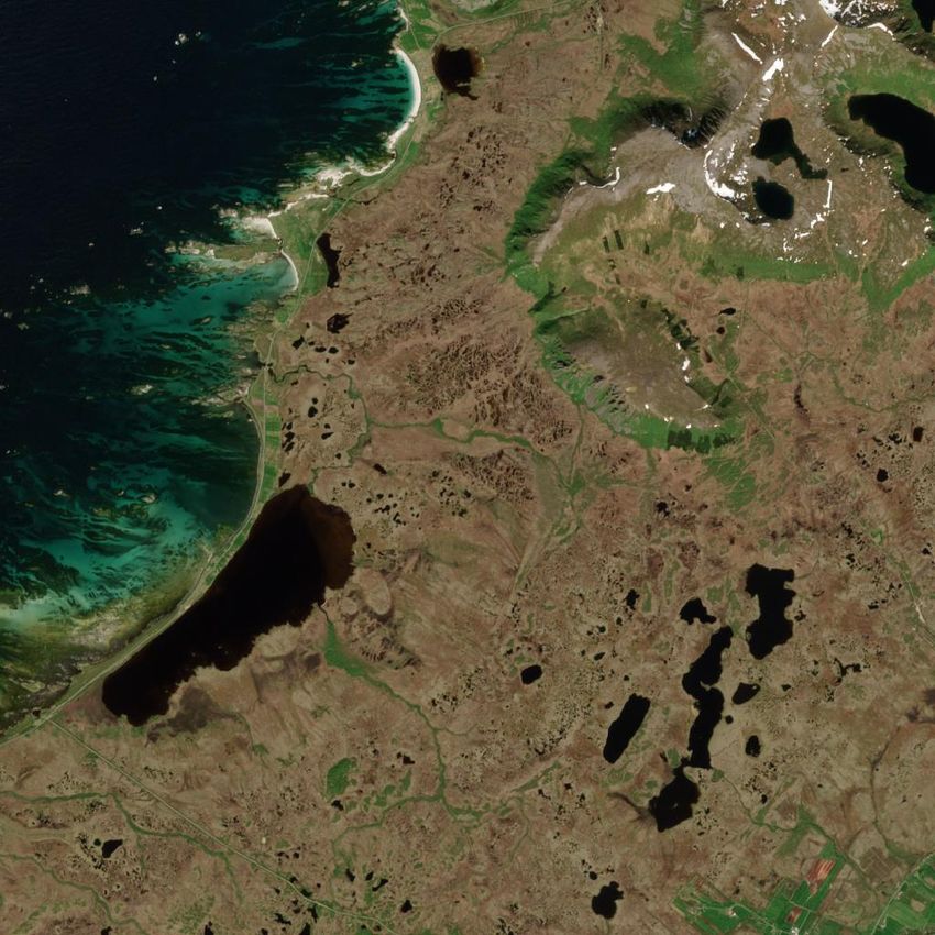
(IN REVIEW)                                                                                                                                                     10

                       Brandon Leshchinskiy is a dual SM candidate                                           Océane Boulais is a Research Engineer at the Na-
                       studying Aeronautics & Astronautics and Technol-                                      tional Oceanic and Atmospheric Agency and North-
                       ogy & Policy at the Massachusetts Institute of                                        ern Gulf Institute leadingthe development of real-
                       Technology. He works with Apollo Professor and                                        time classification and detection algorithms for in-
                       former NASA Deputy Administrator Dava Newman,                                         situ habitat cameras to quantify reef fish species and
                       building AI tools to adapt to climate change and                                      bycatch heuristics from electronic monitoring sys-
                       educational tools to stop it. Prior to graduate school,                               tems aboard shrimp trawlers in the Gulf of Mexico.
                       Brandon worked as a data scientist at MIT Lincoln                                     She holds a Master’s degree from MIT Media Lab’s
                       Laboratory, where he developed technologies for                                       Responsive Environment group in she was involved
                       American security. Brandon holds a B.S. in electrical                                 in fieldwork with National Geographic’s Exploration
                       engineering from Penn State University. Outside of                                    Technology Lab deploying drop cameras to perform
work, Brandon dances, plays piano, and does improv theater. Or at least, he        benthic floor mapping in the Galapagos and collaborations with NGO Con-
did before Covid.                                                                  servation International to design and deploy a computer vision system for
                                                                                   marine resource management aboard Pacific Island tuna fishery vessels.

                                                                                                         Aruna Sankaranarayanan is a Master’s student
                           Christian Requena-Mesa is a PhD Student in                                    at the MIT Media Lab’s Viral Communications
                           environmental science at the Department Biogeo-                               group and works with Prof. Andrew Lippman. She
                           chemical Integration, Max Planck Institute for Bio-                           is interested in misinformation, Earth observation,
                           geochemistry and the German Aerospace Center                                  and climate change. Prior to joining MIT, she has
                           (DLR). He is interested on how novel computer                                 contributed to open-source work at the Humanitarian
                           vision and generative algorithms can improve en-                              OpenStreetMap Team, worked as an infrastructure
                           vironmental monitoring, as well as, how artificial                            engineer at Mapbox, and contributed to the GCom-
                           general intelligence can lead to a better environmen-                         pris Project. She worked with Dr. Abhishek Nagaraj
                           tal management and decision making. His vision for                            at University of California Berkeley on analyzing
                           environmental problem solving relies on the use of                            the contributing community of OpenStreetMap. She
                           deep learning as a dynamic adviser to help us set       holds a B.Sc. in Computer Science from the BMS Institute of Technology
the rules by which humans best interact with the environment. He believes          and Management. Apart from work, Aruna is an avid writer and interested in
that current artificial intelligence can help in finding the equilibrium that      outreach activities.
maximizes both: the benefits we get from nature, and the stability and
resilience of the natural systems.

                                                                                                           Aaron Piña is a AAAS Science and Technology
                                                                                                           Policy Fellow at NASA Headquarters. He works as
                                                                                                           a Deputy Program Scientist in the Science Mission
                                                                                                           Directorate, Earth Science Division to support the
                        Farrukh Chishtie is an atmospheric and Earth
                                                                                                           Weather and Atmospheric Dynamics Focus Area
                        observation scientist with extensive experience in
                                                                                                           in weather research, data, and technology. Prior to
                        various experimental and modelling disciplines. He
                                                                                                           joining NASA Headquarters, Aaron worked as a
                        has more than seventeen years of research experi-
                                                                                                           scientist for Aeris, LLC. Aaron earned his B.S.
                        ence, which includes work with the USAID NASA
                                                                                                           degree in Meteorology from Texas A&M University,
                        SERVIR-Mekong Program and Cloud Physics and
                                                                                                           his M.S. in Atmospheric Science from Colorado
                        Severe Weather Research Section, Environment and
                                                                                                           State University, and his Ph.D. in Ecology from
                        Climate Change Canada (ECCC). He was part of the
                                                                                   Colorado State University. He is a member of the American Meteorological
                        Canadian CloudSat CALIPSO Validation (C3VP)
                                                                                   Society, the American Geophysical Union, and the American Association for
                        project. He holds doctoral degrees in both Natural
                                                                                   the Advancement of Science.
                        and Social Sciences from the University of Western
Ontario, Canada with undergraduate and graduate degrees in engineering and
applied mathematics from the USA. Presently, he holds visiting scientist and
faculty positions at ECCC, CERN Theory Group, University of Toronto and
University of Western Ontario.

                                                                                                            Yarin Gal leads the Oxford Applied and Theoretical
                                                                                                            Machine Learning group (OATML) at the University
                                                                                                            of Oxford. He is the Associate Professor of Machine
                                                                                                            Learning at the Computer Science department, and
                        Natalia Dı́az-Rodriguez is Assistant Prof. of Arti-                                 is also the Tutorial Fellow in Computer Science at
                        ficial Intelligence at the Autonomous Systems and                                   Christ Church, Oxford, and an AI Fellow at the
                        Robotics Lab (U2IS) at ENSTA Paris, Institut Poly-                                  Alan Turing Institute, the UK’s national institute for
                        technique Paris. She also belongs to the INRIA                                      artificial intelligence. Prior to his move to Oxford he
                        Flowers team on developmental robotics. Her re-                                     was a Research Fellow in Computer Science at St
                        search interests include deep, reinforcement and un-                                Catharine’s College at the University of Cambridge.
                        supervised learning, (state) representation learning,                               He obtained his PhD from the Cambridge machine
                        explainable AI and AI for social good. She is work-        learning group, working with Zoubin Ghahramani FRS and funded by the
                        ing on open-ended learning and continual/lifelong          Google Europe Doctoral Fellowship. Yarin made substantial contributions to
                        learning for applications in computer vision and           early work in modern Bayesian deep learning quantifying uncertainty in deep
                        robotics. Her background is on knowledge engineer-         learning and developed ML/AI tools that can inform their users when the
ing (semantic web, ontologies and knowledge graphs) and is interested in           tools are “guessing at random“. These tools have been deployed widely in
neural-symbolic approaches to practical applications of AI.                        industry and academia, with the tools used in medical applications, robotics,
                                                                                   computer vision, astronomy, in the sciences, and by NASA.
You can also read