Revision of the Portuguese catalog of tsunamis - NHESS ...
←
→
Page content transcription
If your browser does not render page correctly, please read the page content below
Nat. Hazards Earth Syst. Sci., 9, 25–42, 2009
www.nat-hazards-earth-syst-sci.net/9/25/2009/                                                      Natural Hazards
© Author(s) 2009. This work is distributed under                                                         and Earth
the Creative Commons Attribution 3.0 License.                                                     System Sciences

Revision of the Portuguese catalog of tsunamis
M. A. Baptista1 and J. M. Miranda2
1 Instituto   Superior Engenharia de Lisboa, CGUL, IDL, Lisboa, Portugal
2 University    of Lisbon, CGUL, IDL, Lisbon, Portugal
Received: 19 August 2008 – Revised: 19 November 2008 – Accepted: 28 November 2008 – Published: 9 January 2009

Abstract. Catastrophic tsunamis are described in historical         Gulf of Cadiz affect a large area, particularly SW Portu-
sources for all regions around the Gulf of Cadiz, at least since    gal, South Spain and Morocco; the largest ones affect the
60 BC. Most of the known events are associated with mod-            SW Irish and UK coasts and the Caribbean (e.g. Haslet and
erate to large earthquakes and among them the better stud-          Bryant, 2008).
ied is 1 November 1755. We present here a review of the                The oldest catalog of earthquakes and tsunamis written
events which effects, on the coasts of the Portuguese main-         in Portuguese is called “Historia Universal dos Terramotos
land and Madeira Island, are well described in historical doc-      que tem havido no mundo de que há noticia desde a sua
uments or have been measured by tide gauges since the in-           criação até ao século presente” (Universal History of Earth-
stallation of these instruments. For a few we include new           quakes occurred around the world, since its creation up to
relevant information for the assessment of the tsunami gen-         the current century) published by Mendonça (1758). This
eration or effects, and we discard events that are included in      book refers to previous written Portuguese sources such as
existing compilations but are not supported by quality his-         Brito (1597) and Sousa (1678) that are themselves compi-
torical sources or instrumental records. We quote the most          lations of historical facts where earthquakes and tsunamis
relevant quantitative descriptions of tsunami effects on the        are reported among other miscellaneous events, as written
Portuguese coast, including in all pertinent cases a critical re-   Portuguese sources prior to the fourteenth century are rather
view of the coeval sources, to establish a homogenous event         scarce. Mendonça (1758) devotes part of his book to the
list. When available, instrumental information is presented.        1755 event and its aftershock sequence. For all events prior
We complement all this information with a summary of the            to 1755 we also extensively considered the answers to the
conclusions established by paleo-tsunami research.                  Marques de Pombal inquiry, question ten: “Do you remem-
                                                                    ber other earthquakes in the past, at your place, and what
                                                                    damage it caused?” Most answers were transcribed directly
                                                                    from the Arquivos do Ministério do Reino (1756) by Runa
1   Introduction
                                                                    and Freire (1991).
Catastrophic tsunamis are described in historical records re-          The second relevant compilation was written by Per-
lated with all countries around the Gulf of Cadiz (El Mrabet,       rey (1847), and is called “Sur les Tremblements de Terre
1991; Campos, 1992; Baptista et al., 1998a), a key tsunami          de la Peninsule Iberique” (About Earthquakes in the Iberian
prone area in Europe associated with the western segment            Peninsula). Perrey (1847) often quotes Mendonça (1758) for
of the Eurasia-Nubia plate boundary. Tsunami events are a           the Portuguese events but in some cases he gives information
consequence of the compressive tectonic environment of the          on original sources which were obtained and cross checked.
Ibero-Maghrebian area (Baptista et al., 1998b; Zitellini et al.,    A few years after Perrey, Robert Mallet (1852) presented a
2001; Gracia et al., 2002; Gutscher et al., 2006), the tran-        new catalog of earthquakes between 1606 BC and 1850 AD
scurrent motion along the Gloria Fault and surrounding area         where several historical events are reviewed.
(Kaabouben et al., 2008) or the effect of far away sources             Rodriguez (1932) published the first modern catalog of
(e.g. Azores or Grand Banks). Events generated within the           seismic events for Iberia, where several tsunami events are
                                                                    described. Heck (1947) published a list of seismic sea waves
                                                                    where the events of 27 December 1722, 1 November 1755
                       Correspondence to: M. A. Baptista            and 31 March 1761 are included, but mainly based on Mal-
                       (mabaptista@dec.isel.ipl.pt)                 let (1852) descriptions. Berninghausen (1964) published

Published by Copernicus Publications on behalf of the European Geosciences Union.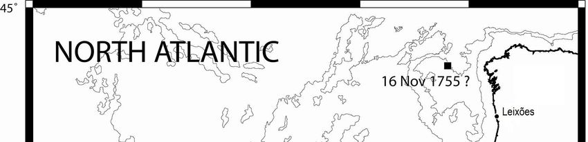
26 M. A. Baptista and J. M. Miranda: Portuguese catalog of tsunamis
a list of tsunamis and seismic seiches for eastern Atlantic et al., 1979, 2004; Baptista et al., 1998a, b); however, a list
south of the Bay of Biscay, in the Bulletin of Seimolog- of tsunami effects is included in the present study, as com-
ical Society of America; this compilation starts with the plementary information to support hazard studies. A similar
26 January 1531 event and does not consider any previ- situation arises in what concerns the 27 December 1722, the
ous tsunami event. This list includes, among others, events 31 March 1761 and the 26 May 1975 events.
on 26 December 1746, 28 April 1758 and 4 July 1809.
These events, not included in the GITEC catalog (Tinti et al.,
1999) are analysed here. For the aftershock sequence of the 2 Description of the historical events
1755 earthquake the author reports only one tsunami event
(29 March 1756), as we do. We must also refer the pioneer- 2.1 The 60 BC Portugal and Galicia tsunami
ing work of Moreira (1968) that also gathered a number of
The M=8.5 earthquake dated 60 BC is the oldest event often
mareographic records, some of them used here.
considered in Portuguese earthquake catalogs (LNEC, 1986;
Most major tsunamis are known only from historical
Sousa et al., 1992; Martins and Victor, 2001). Sousa (1678)
sources. In recent times, the press is also an important
gives one of the rare descriptions of the tsunami: “[. . . ]
source of information, particularly in what concerns flooding
About these years, or slightly before, took place that remark-
and harbor effects. Descriptions presented here come from
able earthquake on the coasts of Portugal and Galicia, with
coeval sources except for the events prior to 1500, due to
which many places were ruined [. . . ]. And the sea leaving in
the fact that these sources are quite rare in Portugal. After
some places its ordinary limits occupied a part of the land,
1881 we have access to tsunami instrumental data in the Por-
uncovering it in other places where it was never seen before
tuguese coasts: the first Portuguese tide station was installed
[. . . ] At Cape St. Vincent a bull gave birth to a mare [. . . ].
at Cascais in 1881 and the second one at Lagos in 1908. All
Very sad augury to the coasts of Lusitania, this monster, in
tide records from these stations were checked for tsunami
the opinion of the professors [. . . ]”. Mendonça (1758) re-
effects related with M>6 seismic events in the SW Iberian
ports this event but only quoting Sousa (1678).
margin. In particular tide records of Cascais and Lagos were
obtained for the events of 25 November 1941, 28 Febru- 2.2 The 382 AD Cape St. Vincent tsunami
ary 1969 (Gjevik et al., 1997), 26 May 1975 (Kaabouben
et al., 2008), and 1 January 1980. Mareograms obtained in The 382 AD tsunami is briefly described by Brito (1597):
the Portuguese tide gauge network have also been used for “[. . . ] the rise of the sea subverted a part of the land and over-
the 1929 Grand Banks tsunami (Fine et al., 2005). Unfor- topped some islands [. . . ] of which some rocks remained in
tunately no stations were operating during the Cadiz earth- the middle of the sea, which can be seen close or inside the
quake of 1964 and so we cannot evaluate its effect on the ocean, mainly in Cape St. Vincent [. . . ]”. The Martins and
Portuguese coasts. In some cases, complementary tide gauge Victor (2001) catalog evaluates the magnitude of the corre-
stations installed at Portuguese harbors (e.g. Leixões) were sponding earthquake as 7.5.
also used to assess tsunami effects.
Very large non-seismic tsunamis have been evoked as a 2.3 The 26 January 1531 Tagus Estuary tsunami
possible source of tsunami hazard in Portugal (e.g. Ward and
Day, 2001) but up to now their effects on the Portuguese On the 26 January 1531, between 4 and 5 a.m., a strong
coasts have not been proved either by instruments, histori- shock was felt in Lisbon and along the Tagus Valley. The
cal documents or sedimentary record. However, we consider shock heavily destroyed Lisbon downtown and neighbouring
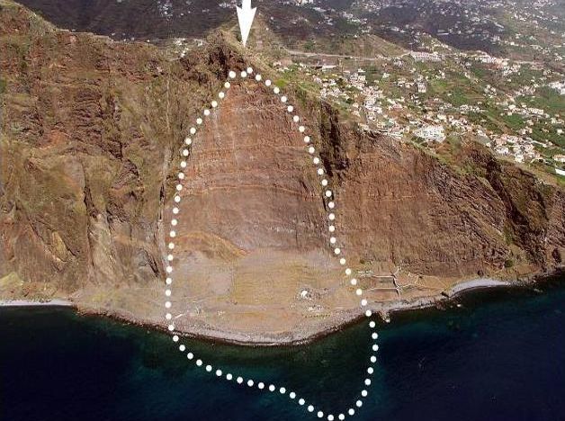
as non-seismic events the 1930 rock fall in Madeira Islands, areas, causing approximately 1000 casualties (Vogt, 1985;
which effects are described in this work, and the 1929 Grand Justo and Salwa, 1998). The downtown of Lisbon and sev-
Banks tsunami that was recorded in the Azores and Leixões eral dwellings along estuary were flooded by the river and
(close to Oporto, northern Portugal). There are some addi- ships in the harbour were left in dry. The maximum reported
tional evidences for other non-seismic events but their iden- earthquake intensity is X (MSK) making it one of the most
tification in historical records is up to now inconclusive. disastrous earthquakes in the history of Portugal. Approx-
In this work we discuss only the events that produced ef- imate epicentre coordinates inferred from the macroseismic
fects on the Portuguese mainland coasts. In this sense, we field are 38.9◦ N, 9.0◦ W (Martins and Victor, 2001) but its
do not consider those generated in the Azores plateau and tectonic source remained uncertain. Justo and Salwa (1998)
only recorded there, which have been the object of a recent locate it NE of Lisbon, up Tagus estuary and it was probably
publication by Andrade et al. (2006). All locations are com- generated north of the Tagus Estuary close to Vila Franca de
plemented with their geographical coordinates (cf. Table 1), Xira town (−9◦ E, 38.9◦ N).
to allow the use of tsunami historical information by non The description of a large tempest in the sea is often re-
Portuguese researchers. In what concerns the 1 November peated: “[. . . ] several vessels were swallowed by the pits of
1755 tsunami the descriptions are summarized, because it the grown and turbulent sea [. . . ]” (Laurent Surius, 1567;
has been the subject of a number of previous works (Solares Babinet, 1861); “Many ships submerged with the tempest
Nat. Hazards Earth Syst. Sci., 9, 25–42, 2009 www.nat-hazards-earth-syst-sci.net/9/25/2009/M. A. Baptista and J. M. Miranda: Portuguese catalog of tsunamis 27
Table 1. Geographical coordinates of the locations included in the text.
Location Longitude Latitude Location Longitude Latitude
Adra −3.017◦ E 36.750◦ N Lagos −8.673◦ E 37.102◦ N
Águeda −8.448◦ E 40.574◦ N Machico −16.764◦ E 32.718◦ N
Alandroal −7.400◦ E 38.533◦ N Malaga −4.417◦ E 36.717◦ N
Albufeira −8.252◦ E 37.089◦ N Matosinhos −8.680◦ E 41.183◦ N
Angra (Terceira) −27.217◦ E 38.650◦ N Monte Gordo −7.449◦ E 37.182◦ N
Assumar −7.383◦ E 39.133◦ N Mount’s bay −5.525◦ E 50.129◦ N
Aveiro −8.654◦ E 40.641◦ N Newlyn −5.547◦ E 50.105◦ N
Ayamonte −7.410◦ E 37.215◦ N Oporto −8.610◦ E 41.150◦ N
Barcelona 2.170◦ E 41.388◦ N Penzance −5.528◦ E 50.118◦ N
Benavente −8.820◦ E 38.978◦ N Pombal −8.627◦ E 39.914◦ N
Buarcos −8.883◦ E 40.167◦ N Ponta Delgada −25.670◦ E 37.738◦ N
Cabo Ruivo −9.097◦ E 38.750◦ N Pontinha (Madeira) −16.918◦ E 32.641◦ N
Cacilhas −9.149◦ E 38.686◦ N Porto da Cruz −16.819◦ E 32.767◦ N
Cadiz −6.292◦ E 36.530◦ N Porto Santo −16.332◦ E 33.059◦ N
Casablanca −7.632◦ E 33.605◦ N Puerto de Santa Maria −6.228◦ E 36.597◦ N
Cascais −9.422◦ E 38.697◦ N Punta Umbria −6.967◦ E 37.182◦ N
Castro Marim −7.445◦ E 37.217◦ N Quarteira −8.104◦ E 37.068◦ N
Coimbra −8.429◦ E 40.211◦ N Santa Cruz de Tenerife −16.255◦ E 28.470◦ N
Conceição de Tavira −7.605◦ E 37.146◦ N S Jorge (Azores) −28.053◦ E 38.645◦ N
Doñana spit −6.589◦ ,E 37.018◦ N Santiago de Compostella −8.544◦ E 42.878◦ N
Douro embankment −8.669◦ E 41.137◦ N Cape St. Vincent −8.994◦ E 37.025◦ N
Espinhel −08◦ 290 E 40◦ 340 N Scilly Island −6.323◦ E 49.936◦ N
Faro −7.935◦ E 37.015◦ N Setúbal −8.893◦ E 38.525◦ N
Figueira da Foz −8.851◦ E 40.151◦ N Sines −8.876◦ E 37.951◦ N
Funchal −16.913◦ E 32.644◦ N Tavira −7.650◦ E 37.126◦ N
Gibraltar −5.353◦ E 36.145◦ N Terreiro do Paço −9.137◦ E 38.708◦ N
Girão Cape −17.006◦ E 32.657◦ N Tróia −8.859◦ E 38.454◦ N
Guincho Beach −9.474◦ E 38.730◦ N Valedelagrana −6.226◦ E 36.578◦ N
Kinsale −8.513◦ E 51.695◦ N Várzea São Brás and S. Lourenço −7.226◦ E 38.859◦ N
Horta (Faial Island) −28.624◦ E 38.532◦ N Viana do Castelo −8.830◦ E 41.695◦ N
La Coruna −8.395◦ E 43.371◦ N Vigário Beach −16.980◦ E 32.649◦ N
Lagoa −8.453◦ E 37.135◦ N Vila Franca de Xira −8.990◦ E 38.954◦ N
that intensified (Codex 9857). Resende (1554) stated that An undated manuscript founded inside a copy of the 1495
“water rose with no wind”, emphasizing the fact that the Portuguese version of De Vita Cristi (that was supposed to
weather conditions associated with a tempest were missing. be the first printed book in Portugal) describes: “[. . . ] car-
Most of the observations concerning water disturbance come avels at sea, fishing at 40 fathom depth, found themselves in
from inside the estuary: Couto (1778) describes the sea agita- dry land”. “[. . . ] an awful earth quake with much roar from
tion close to Lisbon downtown: “[. . . ] in the sea the tempest the sea, and rivers, which came out of their reach, so that,
was so great that destroyed and broke all ships staying in Lis- the Tagus, that divided into several branches, some islets,
bon harbor, some say that the Tagus river opened by its mid- which we call lezirias [. . . ]” (Oliveira, no date). Upriver, in
dle splitting its waters into a pathway and showing the sand Vila-Franca-de-Xira, the description is: “[. . . ] some sailors
bed”. Also Osório (1919) describes “[. . . ] the ships, sailors say [. . . ] in this same river they saw the sky opening and
said, seemed to go in the sky; and (then) against the rocks; it seemed like a burning oven and they saw coming out of
and the river open by its middle and close again” (Osório, it a large thunder with a large flame: and it was close to
1919). The Codex 8009 from the Portuguese National Li- Vila Franca (Osório, 1919)”. Perrey (1847) describes the
brary quotes: “[. . . ] Tagus with its violent tide fluxes and the following: “The sea awfully inflated swallowed a number of
furious agitation of the waves, rose in such a way that it sub- vessels. Tagus water, violently pushed by sea flood, spread
merged many ships, one claims that it opened in the middle above the margins and showed the dry riverbed”; however,
of its waters, showing the sand of its bottom [. . . ]”. he gives no specific source for the information.
www.nat-hazards-earth-syst-sci.net/9/25/2009/ Nat. Hazards Earth Syst. Sci., 9, 25–42, 200928 M. A. Baptista and J. M. Miranda: Portuguese catalog of tsunamis
Beside the above descriptions, extra information can be closed waters was observed in faraway places like Scotland
obtained from the Inquiry conducted by the Marquis of Pom- and Switzerland (see Chambers, 1757; Bewick, 1757; Bor-
bal. The priest of Várzea São Brás and S. Lourenço, from lase, 1755; Mendonça, 1758, and Trembley, 1755, published
Elvas municipality “[. . . ] In the same year, the 26th of the in 1757).
same month, another earthquake happened in Lisbon, and it Lisbon: The water in the Tagus Estuary rose several times,
was felt in a distance larger than sixty leagues [. . . ] and many and in a few minutes made three fluxes and refluxes ris-
ship submerged in the sea” (Sousa, vol. II, p. 370, 1919). The ing above the highest spring tides two spans or fifteen En-
priest from Benavente also comments: “[. . . ] Also in the glish feet [. . . ] when the high tide had run up three parts
time of King D. Manuel, [. . . ] there was one so big that one of it (Sachetti, 1756, published in 1757). “[. . . ] the sea re-
saw river Tagus rising so high that it poured and overflowed treated, showing its bottom along the margins never seen be-
both streams” (idem). fore” (Mendonça, 1758). According to an anonymous let-
ter dated the 18 November 1755 (Nozes, 157–189, 1990)
“[. . . ] suddenly I heard a great uproar: “the sea is rising”
2.4 The 27 December 1722 Tavira tsunami [. . . ] suddenly an enormous water mass appeared at a close
distance rising like a mountain [. . . ]”. Three years later,
On 27 December 1722 an earthquake stroke Tavira (Al- Mendonça (1758) describes: “[. . . ] all of a sudden the sea en-
garve) at approximately 5–6 p.m. It was felt all over Algarve, tered the bar with a furious inundation [. . . ] however cross-
from San Vincent Cape up to the Spanish border (Mendonça, ing the previous limits, overtopped many buildings and inun-
1758). This information is reproduced in most seismic cat- dated São Paulo quarter [. . . ]”. Silva (1756) describes “[. . . ]
alogs (e.g. Rodriguez, 1932; Runa and Freire, 1991; Mar- it flooded in some places with its flux and reflux [. . . ] the
tins and Victor, 2001). The flooding of Tavira area is well Custom House, the Terreiro and the Vedoria [. . . ]”. These
documented and persisted in the collective memory of the (and similar) descriptions allow to conclude that the water in-
population. According to the “Chronica Serafica da Santa vaded Lisbon downtown in approximately 250 m, being con-
Provincia dos Algarves” (Belém, cap. XXII, 200–201, 1750) tained partially by the old city wall built by King D. Fer-
some days after, a thanksgiving procession took place in the nando.
town of Tavira, which was repeated every year since, in the Setubal: The Gentleman’s Magazine of 1755 quotes a
same day of 27 December, with the presence of the Senate, letter dated 4 December from Utrecht where we can read:
the Communities and a large amount of people, “to keep the “[. . . ] Letters by the last post advice that no traces are left
memory of the great benefit, although the large damage suf- of St Ubes [Setubal], the repeated shocks and the vast surf
fered, the entire town could have been entirely submerged” of the sea having jointly concurred to swallow it up. It could
(Belém, 1750). the less withstand them, as it was situate at the head of a little
Using numerical tsunami modeling and multi-channel gulf formed by the tide at the mouth of the [Sado] . . . ” (Ur-
seismic processing, Baptista et al. (2007) estimated that the ban, 1755). The Sea destroyed the city walls entering the city
source of the 1722 Tavira earthquake had a magnitude circa almost a quarter of a mile, carrying the boats to the streets (in
Mw =6.5, and an epicenter close to −7.82◦ E, 37.02◦ N, in the Sousa, 1919). The sea carried 2 boats for more than 50 steps
submarine area close to the Algarve shore. (∼45 m) in land (Mendonça, 1758).
Porto: (or Oporto) is the second Portuguese town after
Lisbon, located close to the Douro embankment in northern
2.5 The 1 November 1755 transatlantic tsunami Portugal. The 1755 tsunami is described here in the follow-
ing way: “The river which rose and fell surprisingly every
There are several compilations of historical documents con- quarter of an hour, for upwards of four hours at least, four or
cerning the 1 November 1755 tsunami and earthquake (e.g. five feet, and sometimes more (Ellicot, 1757). In the Gen-
Solares et al., 1979; Levret, 1991; Baptista et al., 1998a, tlemen’s magazine we can read: “[. . . ] The effect it had on
b; Solares and Arroyo, 2004). It devastated the Iberian and the river was amazing; the tide rose considerably higher than
north Morocco coasts, causing great damage and casualties. was ever known except in case of flood; and the flux and re-
It was observed all over North Atlantic coasts and in cen- flux was so sudden, that in a minute or two it rose and fell
tral and south America. The magnitude of the earthquake five or six feet and continued for two or three hours. “[. . . ]
was recently re-evaluated from the macroseismic field as It ran up at the first with so much violence that it broke a
Mw =8.5±0.3 (Solares and Arroyo, 2004). Dutchman’s hawser. Two of our Brazil fleet were going out,
Reports describe 10–15 m waves at Cape St. Vincent and and had got to the bar, but the sea was so violently affected,
along the Gulf of Cadiz. In Lisbon the number of casual- that it forced them in again; they ran foul of each other, and
ties, due exclusively to the tsunami, is estimated as close were greatly damaged. The agitation was so great in the sea
to 900 and the run in, in Lisbon downtown, is estimated about a league beyond the bar, that, ‘tis imagined the air got
as 250 m (Baptista, 1998a). The effects of the tsunami are vent there“[. . . ] (Urban, 1755).
described in Madeira, Cadiz and Cornwall, and agitation of
Nat. Hazards Earth Syst. Sci., 9, 25–42, 2009 www.nat-hazards-earth-syst-sci.net/9/25/2009/M. A. Baptista and J. M. Miranda: Portuguese catalog of tsunamis 29
Figueira da Foz: “[. . . ] however the biggest new was on Lagoa: The newspaper Gazeta de Lisboa (1755) de-
the sea [. . . ] by 10 o’clock and a quarter of the day, it started scribes: “[. . . ] the sea on this coast raised many poles above
rising such water mounts [. . . ] growing above the natural its surface, entering the margins and inundating the fields;
order 44 palms, more or less [. . . ] for 3 or 4 times [. . . ] un- and when retreating, took with it the existing Fortresses”.
covering rocks and sand never seen before [. . . ]” (Arquivos Madeira: “[. . . ] November the 1st, 1755, in the city of
do Ministério do Reino, 1756). Funchal, on the Island of Madeira, at half an hour past nine
Algarve: “[. . . ] The Sea of that coast raised so many poles o’clock in the morning, was perceived the shock of an earth-
(one pole ∼2.10 m) above its ordinary surface, that it flooded quake [. . . ] About an hour and a half after the shock had
many fields, and when retreating destroyed some fortresses, ceased, the sea, which was calm (it being a fine day, and no
and all the town of Albufeira, leaving a large amount of fish wind stirring) was observed to retire suddenly some paces,
on the bushes [. . . ]” (Gazeta de Lisboa, 1755; Mendonça, and, arising with a great swell, without the least noise, as
1758). Almost one century afterwards Lopes (1841) de- suddenly advancing, overflowed the shore, and entered into
scribes: “[. . . ] By 9 and 1/2 in the morning [. . . ] a great the city. It arose full fifteen feet perpendicular above high
thunder was heard and 3 or 4 minutes after the land shook water mark [. . . ]” (Heberden, 1755 letter published in 1757).
with violence; the sea retreated partially more than 20 fathom [. . . ] the sea all on a sudden rises as though it were the main
leaving the beach dry; and immediately rushing over the land body of it [. . . ] November 3. Thank God we have no return
with such an impetus that it entered more than one league, of the earthquake, nor was the rising of the sea attended with
overtopping the higher rocks; retreating and breaching three any bad consequences in our part of the Island; though we
times in a few minutes, dragging in the flux and reflux enor- hear, that at Machico and Porto da Cruz it did considerable
mous masses of cliffs and buildings, thus destroying almost damage [. . . ] and when the sea recoiled, it was so far from
all maritime villages”. its usual limits, as to discover the foundation of rocks, that
Lagos: Following MDJF (1756) “[. . . ] the sea entered never had been seen and which lay as far distant from the
onshore 7 poles high: the very strong city walls suffered with shore as our islet [. . . ] the distance referred from the shore to
this misfortune [. . . ]”. An eyewitness report in Rocha (1991; the islet, something more than 200 yards (Chambers, 1755).
in Costa et al., 2005) says: ”[. . . ] an awful earthquake with Porto Santo: ”[. . . ] on the 1st November 1755, we felt
alteration in the sea, that in a few minutes ruined the city [. . . ] in this island the shock of a violent earthquake [. . . ] the sea
the sea rising up till 13 and half palms high [. . . ]. come out of its ordinary limits, about 10 o’clock, in the morn-
Albufeira: “[. . . ] it was the defeat; those that es- ing, running in a quarter mile [. . . ] to a place called Estanco
caped the earthquake could not escape from the sea” (MDJF, Velho. In spite of the fact that this is not a coeval source the
1756). The priest reports in “Memórias Paroquiais”(IANTT, results are coherent with the reports of Madeira Island (Anais
1758) [. . . ]the sea out of its limits entered the city and took de Porto Santo, in Sousa, 1919).
all the quartier of Saint Ana, that included 7 streets, and many
more houses, without leaving, in its flux and reflux any sign 2.6 The 16 November 1755 La Coruna tsunami
of the houses and made many casualties [. . . ]. The newspa-
per Gazeta de Lisboa (1755), reports: ”[. . . ]when the sea re- According to Mendonça (1758) “[. . . ] On the 16 Novem-
treated took the fortress [. . . ] and the whole city of Albufeira ber, about half past three there was a big explosion. It was
[. . . ] leaving lots of fish in fields [. . . ]. felt in Santiago de Compostella and Coruña, where it caused
Faro: The city of Faro, separated from the sea by a barrier some damage as well as flux and reflux of the sea [. . . ]”.
island, was protected against tsunami effects, according to The catalog of Rodriguez (1932) reports this event quoting
the report of Castro (1786): “[. . . ] Faro had the fortune that Mendonça (1758). Perrey (1847) includes the following de-
its river was on low tide [. . . ]. We could see the rising of the scription: “The 16th , 3 hours 30 minutes in the afternoon, at
waves at the coast in such height that each one (all together) Lisbon, the land subsided, and made the same effect as a try-
mounted the island without splitting itself. Entering the river ing ship; the sea inflated in a prodigious way”.
[. . . ] distributed in an number of foam waves[. . . ]in the city
2.7 The 29 March 1756 Lisbon tsunami
they cause minor impression, where the waters did not ex-
ceed the limits of a great tide [. . . ]” (Castro, 1786). “[. . . ] Perrey (1847) describes: “The 29th, in the morning, at Lis-
suffered the same calamity, submerging half of the place with bon, one violent shock; the water of Tagus raised notice-
all their houses never seen afterwards [. . . ] (MDJF, 1756). ably”; this author quotes the Journal Historique (1756) that
Monte Gordo – Tavira: “[. . . ] The waves took all the reports the aftershock and the agitation in the waters of Tagus
huts from Monte Gordo beach, where there was commerce River, after several letters received from Lisbon. There is no
of fisheries, till the Conceição de Tavira, and destroyed all description in Mendonça (1758) and the earthquake is not
the islands (barrier islands) on the shore till Quarteira [. . . ] included in the catalogs of LNEC (1986), Martins and Vic-
(Relaçam, 1756; in Costa et al., 2005). tor (2001) or Sousa et al. (1992). Rodriguez (1932) included
Castro Marim: “[. . . ] the sea incursion made remarkable the same description in his catalog.
damage [. . . ]” (MDJF, 1756).
www.nat-hazards-earth-syst-sci.net/9/25/2009/ Nat. Hazards Earth Syst. Sci., 9, 25–42, 200930 M. A. Baptista and J. M. Miranda: Portuguese catalog of tsunamis
2.8 The 31 March 1761 North Atlantic tsunami is at least one instrumental record in Coimbra, also used
to locate the epicenter. The Lisbon newspaper Diário de
Most of the original information concerning the 1761 earth- Notı́cias (1926) reports “[. . . ] Great agitation in the Tagus, it
quake and tsunami comes from the newspapers published in was felt in most boats that were leaned to the wall [. . . ]. A cu-
Lisbon (Gazeta de Lisboa) and London (The London Chroni- rious report by several persons, that were using the Tagus fer-
cle) and from the inquiry made at that time by the president of ries, is that the fishes were alarmed with the agitation of the
the Real y Supremo Consejo de Castilla (Royal and Supreme sea and came to the surface in groups [. . . ]. Groups of brave
Council of Castilla) also bishop of Cartagena, Diego de Ro- individuals approached the “Column Quay” to watch what
jas y Contreras, who sent a letter to all local authorities ask- was going on in the river [. . . ]”. This event shares some sim-
ing information about 31 March 1761 earthquake, includ- ilarity with the 1531 Tagus event. Berninghausen (1964) re-
ing reports of the earthquake occurrence, number of victims ports the 1926 tsunami quoting the Seismological Dispatches
and damage (De La Torre, 1997). A series of letters pub- of the University of Georgetwon. Cascais tide gauge station
lished in the Philosophical Transactions of the Royal Soci- shows no clear tsunami waveform; the Seismological Dis-
ety, reproduce and complete the basic descriptions. The first patches of Georgetown university for this year report: ”[. . . ]
study of the 1761 earthquake and tsunami was published by Lisbon, Portugal, Dec. 18 A violent earthquake lasting three
Borlase (1762) in the Philosophical Transactions. Eighty seconds, today alarmed all Lisbon [. . . ]” and for the next
five years later Perrey (1847) and ninety years later Mal- day: ”[. . . ] Lisbon, Portugal Dec. 19 – Lisbon has experi-
let (1852) re-compiled all available data. These compilations enced a severe earthquake. The first shock Saturday lasted
were used in most of the modern studies (e.g. Moreira, 1984; ten seconds. It was accompanied by subterraneous noise;
De La Torre, 1997). All this information is compiled at Bap- the waters of the Tagus river rose considerably and soon the
tista et al. (2006). surface was covered with thousands of fish [. . . ] (Tendorf,
About one hour and a quarter after the earthquake, a 1926).
tsunami was observed in Lisbon (Baptista et al., 2006). Its
2.10 The 18 November 1929 Grande Banks tsunami
amplitude is estimated as eight feet, affecting several ships
that were left dry at some intervals (Molloy, 1761). Sea water On 18 November 1929, 20:32 UTC, a M=7.2 earthquake oc-
changes were also observed along the Spanish coasts, namely curred at the southern edge of the Grand Banks triggering a
Ayamonte, Puerto de Santa Maria, Cadiz and Barcelona but large submarine slump with a volume estimated as 200 km3
Baptista et al. (2006) didn’t find quantitative details on arrival (Fine et al., 2005) that moved along the Laurentian slope,
time or run-up. The tsunami was also observed very sensi- rupturing 12 transatlantic cables and generating a tsunami
bly in Funchal and in Terceira (Azores). Good descriptions that crossed the north Atlantic. The tsunami was recorded
of the tsunami came from southern Ireland and UK, partic- along the eastern seaboard as far south as South Carolina and
ularly Kinsale, where it was observed about six o’clock in across the Atlantic Ocean and in Portugal in Ponta Delgada
the evening, Mounts bay (Cornwall), Penzance and Scilly and Leixões (close to Oporto). Recently Fine et al. (2005)
Islands. There is also a reference for Barbados, where the include observations of tide records in Portugal for Lagos
tide ebbed and flowed, in about eight minutes, between eigh- (south coast), Leixões (north coast) and Azores. This event
teen inches and two feet, which was attributed to the 1761 is one of very few slide-generated teletsunamis (Fine et al.,
tsunami. 2005) and the maximum amplitude in the Portuguese main-
Baptista et al. (2006) used backward ray tracing tech- land coasts was observed at Leixões where it reach ampli-
niques to propose that the 1761.03.31 earthquake had its epi- tudes close to 0.19 m. In Ponta Delgada (Azores) the maxi-
center close to −13◦ E 34.5◦ N and a magnitude close to 8.5. mum observed amplitude was 0.14 m.
A 1773 French document that was made available to us by
Paul-Louis Blanc (personal communication) describing the 2.11 The 4 March 1930 Câmara de Lobos (Madeira)
effects of 12 April 1773 earthquake in Cadiz, that did not Rock Fall
generate a tsunami in that Spanish town, refers indirectly to
the 1761 event: “Hopefully the sea remained quiet, even if An enormous wave, caused by a massive rock fall close to
we feared that it came above itself, as [it happened] in the Girão Cape in Madeira (cf. Fig. 1), entered the Vigario Beach
month of March 1761” (Journal Historique, 1773). This con- 200–300 m in land (Freitas, 1989). The wave caused about
firms the previous assumption on the approximate location of 20 casualties, most of them women surrounded by their chil-
the source and on the regional character of the 1761 tsunami. dren, who were washing their laundry in the Vigario stream
close to the sea. During the water reflux it was possible to see
2.9 The 18 December 1926 Lisbon tsunami women and children carried out by the water and other debris
(Rosa and Fernandes, 1930). Two other slides occurred in
On 18 December 1926, an earthquake occurred in Lisbon, 1894 and in September 2004 at the archipelago of Madeira
at 2:45 p.m. The epicenter coordinates attributed by Mar- (Rodrigues, 2005), their effects on the coast need further in-
tins and Victor (2001) are: −9.20◦ E and 38.70◦ N. There vestigation to be included in the catalog.
Nat. Hazards Earth Syst. Sci., 9, 25–42, 2009 www.nat-hazards-earth-syst-sci.net/9/25/2009/M. A. Baptista and J. M. Miranda: Portuguese catalog of tsunamis 31
2.12 The 8 May 1939 North Atlantic tsunami
An earthquake of magnitude Ms =7.1, occurred with epicen-
tre 37.40◦ N, −23.90◦ E, Azores, (Buforn et al., 1988). A
small tsunami was recorded at the tide stations of Ponta Del-
gada (S. Miguel) and Angra (Terceira Island). According
to the local newspaper “Correio dos Açores” (1939) that
quotes the information from the Azores Meteorological Ser-
vice, the maximum peak to peak amplitude was 0.3 m at
Ponta Delgada. The first shock occurred at 1:47 a.m. (GTM);
three tsunami waves were recorded at Angra at 2:25, 2:29
and 2:45 a.m. The amplitude of Ponta Delgada tide station
(0.30 m) is taken from Moreira (1968) because the original
record is not available. We checked other tide gauge stations
of the Portuguese network to conclude that this tsunami was
not registered in mainland Portugal. Fig. 1. Cape Girão: Recent Aerial photo showing the scar of the
1930 landlside.
2.13 The 25 November 1941 North Atlantic tsunami
The earthquake occurred at 6:03 p.m. on 25 November 1941.
The epicentre coordinates are 37.42◦ N, −19.01◦ E and the
magnitude 8.2 (Martins and Victor, 2001) and the surface
wave magnitude is 8.4. A small tsunami was registered at the 2.14 The 28 February 1969 Horseshoe tsunami
tide stations of Cascais, Lagos, Leixões, Douro (Portugal),
Casablanca (Morocco), Pontinha (Madeira), Ponta Delgada An Ms =7.9 earthquake occurred the 28 February 1969, at
(Azores), Newlin (Cornwall, UK), being the maximum am- 2 h 40 min (TUC) on the SW Iberia margin. Its epicentre
plitude observed 0.45 m (peak to peak) at Casablanca (Mo- was located at −10.57◦ E, 36.01◦ N, and its estimated focal
gador) in Morocco. depth was 22 km (Fukao, 1973). It generated a small ampli-
The Portuguese newspapers report tsunami visual observa- tude tsunami that was recorded in the tide gauges of main-
tions at Tagus estuary: “[. . . ] the phenomenon was also felt land Portugal: Cascais, Lagos, Faro; along Tagus estuary
in Tejo (Tagus), where the waters surge for several seconds. close to Lisbon: Terreiro do Paço, Cacilhas, Cabo Ruivo;
The ships anchored in the river oscillate; this fact caused in the Azores Islands: Horta (Faial Island); in Morocco:
some fear among the crews. In the docks the small ships Casablanca; Spain: Cadiz and in Canaries Islands. The max-
crashed against each other without damage [. . . ]”(Diário de imum amplitude observed was 0.6 m at Casablanca. This
Noticias, 1941a); At Douro estuary the sea overtopped the event is discussed in detail in Baptista et al. (1992), Hein-
beaches to the streets: at Douro estuary the panic was not rich (1994) and Gjevik et al. (1997).
less, caused by the shock but also by the roaring of the sea Most of the information available regards tide gauge
that furiously overtopped the beaches and flood the streets, records but in the harbor of Matosinhos the fishermen off-
reaching St. Bartolomeu Street [. . . ]”; in Vila Franca de Xira: shore, close to the coast, felt a sudden and strong agitation in
“[. . . ] The men at the pier saw, with panic, great waves and the sea, but they were unable to evaluate what happen in the
the Tagus rebelled threatening the walls, at the same time coast (in Diário da Manhã, 29 March 1969).
the ships in the river oscillate like fragile “nut barks” [. . . ]” There is some information concerning seaquake observa-
Diário de Noticias (1941b). tions (Ambraseys, 1985). The ship “Manuel Alfredo” that
The Gibraltar Chronicle, from 26 November 1941, reports was 240 km offshore Sines, was suddenly surprised by a
(p. 2) that “World records big earthquake – Lisbon sways un- strong noise and the crew thought that the ship ran into rocks,
der shock” and says: “[. . . ] London, November 26, Probably then the crew realized it was not possible due to the loca-
the biggest earthquake tremor known, has just been recorded tion of the ship. The crew observed that the water, in the
on the instruments of scientists all over the world [. . . ] how- sea, looked as it was boiling. Some minutes later they knew
ever can not agree as to the exact location [. . . ] it must have through a Moroccan radio that an earthquake happened. The
occurred under the Atlantic Ocean. Some place it between passengers that were asleep, in their cabins, did not panic
the Azores and Madeira [. . . ]” (Gibraltar Chronicle, 1941a) and stayed quiet. A 32 000-tone ship located close to the
On November 27 the same newspaper refers: that yesterday’s Horseshoe Abyssal Plain suffered serious structural damage
earthquake was under the Atlantic, 790 km offshore Portu- and was obliged to return to Lisbon, where it was dry-docked
gal in line with the Azores Island of Sao Miguel” Gibraltar and surveyed (Ambraseys, 1985).
Chronicle (1941b).
www.nat-hazards-earth-syst-sci.net/9/25/2009/ Nat. Hazards Earth Syst. Sci., 9, 25–42, 200932 M. A. Baptista and J. M. Miranda: Portuguese catalog of tsunamis
2.15 The 17 July 1969 tsunami terials landwards from the sea bottom, forming at some dis-
tance inland sand sheets and washover fans with variable tex-
Moreira (1968) gathered a group of three mareograms from tures and grain sizes, sometimes including cobbles, boulders
the tide stations of Santa Cruz de Tenerife (Canary Islands), or even large blocks. Textural variations, sediment content,
Angra (Terceira Island), Lagos and Cascais, where a clear micro and macrofauna, landward variations in thickness and
tsunami signal can be observed. The maximum peak-to-peak height can be used as markers of tsunami deposits (see Luque
amplitude observed on the Portuguese coast is 0.06 m at La- et al., 2002 and references herein). A number of studies have
gos. There is no significant earthquake that we can correlate been conducted in the southwestern coasts of Portugal and
with this event and so we consider it source as “unknown”. Spain (e.g. Andrade, 1992; Dawson et al., 1995; Luque et
al., 2001; Ruiz et al., 2005) contributing for the identifica-
2.16 The 26 May 1975 Gloria Fault tsunami tion of a series of possible events that probably struck the
Portuguese coasts during and before Roman times.
The 26 May 1975 earthquake, of magnitude Ms =7.9, oc-
curred in the North Atlantic close to the Azores archipelago.
3.1 The 6.0–7.0 kyr BP paleotsunami
Its epicentre, as given by USGS, was −17.5◦ E, 35.9◦ N,
200 km south of the Gloria Fault. The tsunami wave was The oldest claimed Holocene tsunami deposit around Cadiz
recorded in a set of coastal tide gauges where amplitudes Gulf was identified by Scheffers and Kelletat (2005) near the
range up to 30 cm in Lagos (see Fig. 2 for locations). Guincho Beach, NW Lisbon. It corresponds to a series of
Kaabouben et al. (2008) presented recently an analysis of the giant boulders and cobbles, located 14 m above mean sea
tsunami data to analyse the earthquake focal mechanism. level, where radiocarbon dating is 6000–7000 yr BP (Schef-
According to Diário dos Açores (1975a, b): ”About fers and Kelletat, 2005). Similar records were not found on
8:15 a.m. (local time) three seismic station of the archipelago the southwestern coast of Spain, but sea level height, close to
recorded an earthquake [. . . ] with epicentre −16◦ E, 37◦ N, its Holocene maximum, generated flooding in estuaries dur-
that is 840 km the East-Southeast of S. Miguel. About ing this period (Dabrio et al., 2000) that could prevent the
9:40 a.m. (local time), at the artificial harbour and in the identification.
“old sardine pier” it was observed a fast withdraw of the sea,
returning just after, reaching the high tide mark. In those
3.2 The 5.3–5.5 kyr BP paleotsunami
places, fertile areas of the bottom remained uncover, and
some boats touched the bottom”. “[. . . ] In Ponta Delgada A later event was identified by Vizcaino et al. (2006), us-
and Horta it was observed a tsunami, caused by the earth- ing a turbidite paleoseismological approach based on the
quake and the tide gauge (in Horta) recorded an oscillation synchronicity between mass wasting deposits filling distant
with maximum amplitude of 34.5 cm”. In Portugal mainland, basins. Radiocarbon dating of an important debris flow on
the maximum observed amplitude was 30.0 cm at Lagos tide a core made offshore, close to Marques de Pombal fault,
gauge. concluded for an age of 5488±98 yr BP. Ruiz et al. (2005)
also claimed to have identified a high energy event approx-
2.17 The 1 January 1980 Azores tsunami
imately dated 5309 yr BP which caused the breakthrough of
On 1 January 1980 an earthquake occurred between Terceira the Doñana spit. If we consider both independent identifica-
and S Jorge islands at 16:42:40 (Azores). The hypocentral tions as the signature of the same event, we can attribute it an
coordinates for this shock were (NEIC) 38.81◦ N, −27.78◦ E, age of 5.3–5.5 kyr BP.
H =10 km, the magnitude is Ms =6.7, Mw =6.8 (Hirn et al.,
1980; Borges et al., 2007). This strike slip event generated 3.3 The 4.2 kyr BP paleotsunami
a small amplitude tsunami recorded at Angra (Terceira Is-
land) and the maximum amplitude observed was 0.3 m peak Ruiz et al. (2005) based on the paleogeographic evolution of
to peak. The following tide records were checked to confirm Doñana National Park claimed the existence of a high energy
the tsunami in Portugal mainland: Aveiro, Viana do Castelo, event in 4153 yr BP.
Faro, Sines; no tsunami signal was found.
3.4 The 3.6 kyr BP paleotsunami
3 Pre-historical events The only positive identification of a high energy event for
the epoch 3.6 kyr BP was made by Vizcaino et al. (2006)
To expand the time span of the tsunami catalog to pre-historic based on a debris flow found in the already described Mar-
times the most important information available regards pale- ques de Pombal core. They attribute it a radiocarbon age of
otsunami studies based on the identification of high energy 3552±35 yr BP. Having no other positive identification from
deposits on the sedimentary record. The observation of re- coastal tsunami deposits we cannot discard the possibility of
cent events shows that water run-up and swash transport ma- a large earthquake that did not generate a significant tsunami,
Nat. Hazards Earth Syst. Sci., 9, 25–42, 2009 www.nat-hazards-earth-syst-sci.net/9/25/2009/M. A. Baptista and J. M. Miranda: Portuguese catalog of tsunamis 33
Fig. 2. Location of the presumed source for most of the events included in Table 2. We include in the figure the events of 1939 and 1980
generated in the Azores but with no significant impact on the mainland Portuguese coasts.
while producing an important debris flow on the SW Por- nature found in Cadiz Bay corresponds to the impact of a
tuguese coast. Ruiz et al. (2005) identified two other high tsunami similar to 1 November 1755 and also that it matches
energy events in 3862 yr BP and 3763 yr BP, which could be the tsunami occurring in roman times in 218 BC, included in
interpreted as a single tsunami layer (Ruiz et al., 2007). the Rodriguez (1932) tsunami catalog.
3.5 The 2.4–2.7 kyr BP paleotsunami
4 The Tsunami catalog
Lario (1996) identified a large erosional episode between
4.1 Structure of the catalog
2700 and 2400 yr BP in Punta Umbria that changed the
drainage system and attributed it to a high energy event. We present in Table 2 a synopsis of all events included in
the Portuguese tsunami catalog. The fields considered there
3.6 The 2.2–2.3 kyr BP paleotsunami characterize the source (location, date and time, sub-region),
the cause classified as Earthquake (submarine earthquake,
A high energy event 2200–2300 yr BP was positively iden- ER, earthquake associated, EA, earthquake landslide, EL,
tified by Luque et al. (2002) on the Valedelagrana Spit Bar earthquake marine slide, ES), Volcano (submarine eruption,
(Bay of Cadiz, Spain), with the input of coarse sands into VO, volcano associated, VA, volcanic landslide, VL, vol-
tidal marsh deposits, similar to the sedimentary signature of canic marine slide, VS) or Slump (gravitative landslide, GL,
the 1755 event in the same place. Vizcaino et al. (2006) gravitative marine slide, GS, gravitational snow avalanche,
found a similar result for a debris flow in the Marques de GA, glacier calving, GC), the reliability (states the uncer-
Pombal core, attributing it a radiocarbon age of 2293±35 yr tainty on the occurrence of each event), and the tsunami size
BP. Luque et al. (2001) consider that the sedimentary sig- (intensity, run up height, and amplitude).
www.nat-hazards-earth-syst-sci.net/9/25/2009/ Nat. Hazards Earth Syst. Sci., 9, 25–42, 200934 M. A. Baptista and J. M. Miranda: Portuguese catalog of tsunamis
Table 2. Date – date of the event; Time – time of the event; Reliability – reliability of the event; Cause: ER (Earthquake); RF (Rock Fall) or
LS (Landslide). The time attributed to the 17 July 1969 tsunami is approximate. Sub-regions of Atlantic (AT) region are coded as: SWIT –
Southwest Iberian Transpressive zone; TE – Tagus Estuary; GFD – Gloria Fault Domain; GB – Grand Banks; MAD – Madeira. Lat and Lon
– Latitude and Longitude in degrees; H – focal depth in km; TI – tsunami intensity; K – tsunami intensity; R – run-up height in (m); A –
Max Amplitude – maximum amplitude observed in the Portuguese tide gauge network (m); in all case Un means “unknown”.
Date Time Relia- Cause Sub- Source TI K– R– A – Max
hh mm ss bility region location Sieberg Imamura Run-up Amplitude
Ambraseys Papadopoulos (m) (m)
N Lati- E Longi- H–
tude tude depth
(km)
60 BC Un 3 ER SWIT 36.00 −10.70 - 4 VII - -
382 AD Un 3 ER SWIT 36.00 −09.50 - 4 VI - -
26 Jan 1531 04:30:00 4 ER TE 38.90 −09.00 - 4 VII - -
27 Dec 1722 17:30:00 4 ER SWIT 37.02 −07.48 - 3 VI - -
26 Dec 1746 - 0 - - - - - - - - -
28 Apr 1752 - 0 - - - - - - - - -
1 Nov 1755 09:40:00 4 ER SWIT 36.70 −09.80 - 6 XI >10 -
2 Nov 1755 - 0 - - - - - - - - -
16 Nov 1755 15:30:00 2 ER SWIT 43.40 −11.00 - 2 III - -
21 Dec 1755 - 0 - - - - - - - - -
31 Jan 1756 - 0 - - - - - - - - -
29 Mar 1756 Un 2 ER TE 38.70 −9.20 - 2 III - -
31 Mar 1761 12:01:00 4 ER GFD 34.50 −13.00 - 3 VI 2.4 -
4 Jul 1809 - 0 - - - - - - - - -
18 Dec 1926 14:45:00 4 ES TE 38.70 −9.20 - 2 IV - -
18 Nov 1929 20:32:00 4 ES GB 44.50 −56.30 - 1 II - 0.19 (Leixões)
4 Mar 1930 18:03:00 4 GL MAD 32.65 −16.97 - 4 VIII >5 -
25 Nov 1941 18:04:00 4 ER GFD 37.42 −19.01 25 1 II - 0.10 (Lagos)
28 Feb 1969 02:40:32 4 ER SWIT 36.01 −10.57 22 2 III - 0.30
17 Jul 1969 05:00:00 4 Un Un Un Un - 1 II - 0.13 (Lagos)
26 May 1975 09:11:51 4 ER GFD 35.90 −17.50 15 1 II - 0.30 (Lagos)
The source location of non-instrumental events is rather boats, damage to buildings, and ranges from I to XII; the au-
uncertain, except if macroseismic data exist and the tsunami thors propose a tentative correlation with water height; the
is inferred from the earthquake source area. If there is no ad- run-up height R, this is the maximum observed in the area
ditional information on tsunami propagation or run-up, epi- affected by the tsunami; the amplitude, A, reveals the ex-
center coordinates (Table 2) are obtained from seismic cata- istence of the tide gauge data and the place and maximum
logs. In our case most events were triggered by earthquakes amplitude observed is reported in the table. The intensity as-
and the corresponding epicentral parameters (longitude, lati- signed to each event is based only upon the descriptions and
tude and depth) are used to estimate the location of the fault reports in spite of the reliability attributed to the event. In the
which movement is supposed to have deformed the seafloor descriptions the Sieberg-Ambraseys’ intensity is represented
and thus, generated the tsunami. The reliability is assessed by TI while the Imamura-Papadopoulos’ intensity is denoted
with Iida 5 grade scale, where 0 means a “very improbable by K (Papadopoulos, 2003).
tsunami” and 4 a “definite tsunami”. The last columns char- We did not compute tsunami magnitudes. This parameter
acterize the tsunami size: the tsunami intensity TI, the run up defined by Murty and Loomis (1980) is related to the ini-
height R, and the amplitude A. tial potential energy of the tsunami integrated all over the
The intensity of the tsunami is described by both Sieberg- tsunami source area. It is only applicable to earthquake gen-
Ambraseys (Ambraseys, 1962) and Imamura-Papadopoulos erated tsunamis and for those cases in which the source pa-
(Papadopoulos, 2003) scales. The Tsunami Intensity in rameters are well established. In such cases it is possible to
the Sieberg-Ambraseys ranges from 1, for a very small compute the solid earth displacement (see Tinti et al., 2004,
tsunami only detected by tide gauges, to 6 for a catas- for details).
trophic tsunami, spreading devastation along coastal areas.
The Tsunami Intensity scale by Imamura and Papadopou-
los (2001) is arranged according to the effects on objects like
Nat. Hazards Earth Syst. Sci., 9, 25–42, 2009 www.nat-hazards-earth-syst-sci.net/9/25/2009/M. A. Baptista and J. M. Miranda: Portuguese catalog of tsunamis 35
4.2 Unreliable events Nacional, 2005) water flux and reflux was also described
in Gibraltar but a tsunami reliability of zero is attributed.
The re-appraisal of the different data sources and the anal- Mendonça (1758) reports aftershocks during the following
ysis of new ones, that was performed in this study, led us day, “in the 24 hours after the earthquake the earth continued
to discard some events, presented in the preliminary GITEC shaking” but no tsunami is reported.
catalogue (Tinti et al., 1996), mainly because they have been The 21 December 1755 event: A description of a tsunami
included in previous catalogs of tsunamis in Iberia (e.g. Per- the 21 December 1755 is included in Rodriguez (1932):
rey, 1847; Mallet, 1952; Rodriguez, 1932; Berninghausen, “[. . . ] At about 9 an earthquake occurred in Lisbon, with two
1964; Moreira, 1991; Campos, 1992). We discard the 26 De- shakings of short duration but so violent that caused damage
cember 1746, the 28 April 1752, the 2 November 1755, the and ruin in the city. The Tagus overflowed. 300 people died
21 December 1755, the 31 January 1756 and the 4 July 1890 in the rubbles and drowned in the waters of this river [. . . ]
events. the realm of Algarve suffered a lot. At the coast the sea ad-
The 26th December 1746 event: Berninghausen (1964) vanced one league. People at Spanish frontier suffered less
reports this event quoting Mallet (1852): “[. . . ] the tide was [. . . ]”. Rodriguez (1932) quotes no original source for the
very low (at the time of the shock) and it was observed that information.
the sea, which had been quite calm, rose considerably [. . . ]. This event is not mentioned in any coeval sources of the
The seismic catalog of Martins and Victor (2001) reports Portuguese archives. Mendonça (1758) devotes the final part
2 earthquakes in 1746, with no specific day and/or month. of his catalog to the aftershocks sequence of the 1755 earth-
The shocks are located at −8.5◦ E, 40.3◦ N, and −7.9◦ E, quake and there is only one event with associated tsunami
38.2◦ N, both with magnitude 3.0. Mendonça (1758) reports (the Coruña 16 November 1755 event): “[. . . ] on the 21, by
only one event for this year, in Lima (Peru). Moreira (1991) 9 o’clock (in the day) there was one that caused so violent
reports events in 1746 with no specific date, felt in Assumar, concussions, that caused in Lisbon and surroundings some
Pombal, Águeda, Espinhel, Alandroal. Some answers from ruins. If it lasted more, there would certainly be more dam-
question number ten of the Marques de Pombal Inquiry that age”. (Mendonça, 1758, p. 62)
are transcribed in Moreira (1991) and Runa and Freire (1991) The 31 January 1756 Lisbon event: According to Ro-
refer to an earthquake ten years before 1756, but no reference driguez (1932) on 31 January 1756 a tidal wave flooded the
is made to a tsunami, as it would be expected as the above lo- coast and left some fish on the sand. However, this catalog
calities are inland, far away from the sea. Perrey (1847), Mal- is the only reference to such event: a contemporary source
let (1852) and Rodriguez (1932) do not mention this event. (Mendonça, 1758) reports: “[. . . ] On January 1756 there
The 28 April 1752 event: This event is listed in Per- were many earthquakes, that I cannot find any memories, and
rey (1847), Rodriguez (1932) and Berninghausen (1964). that I cannot remember, because I just noticed the greater
The description of Berninghausen (1964), quoting Mal- ones on April the 25th (this year) and later on [. . . ]”. Per-
let (1852), says: ”[. . . ] April 28. Portugal. A violent earth- rey (1847) does not include any information on this event. In
quake at Buarcos and Aveiro was accompanied by inunda- the absence of conclusive information from the earthquake
tion”. Mendonça (1758) refers only one event in this year itself, not included in the catalogs of LNEC (1986), Martins
(1752) but on 6 September, at Clermont and Rion (France). and Victor (2001) or Sousa et al. (1992), we conclude that
We checked the answers given to the Inquiry made by the Rodriguez (1932) description must not be taken into consid-
Marquês de Pombal for Buarcos, Aveiro and Figueira da Foz. eration.
Several answers report an event on 23 August 1753. Mor- The 4 July 1809 event: Berninghausen (1964), quoting
eira (1984) also excludes this event on the basis that it is nei- Mallet (1852), reports a tsunami in Portugal on 4 July 1809.
ther reported by Gazeta de Lisboa nor by Mendonça (1758). The description is: “[. . . ] Portugal. No shock listed. An ex-
The catalog of Martins and Victor (2001) includes 2 events traordinary flux and reflux of the sea is observed near Lisbon
in 1752 and none in 1753. [. . . ]”. The Portuguese newspaper for this month Gazeta de
The 2 November 1755 event: The 2 November 1755 Lisboa, July 1809, does not report any sea disturbance. In
event is one among a large sequence of aftershocks of Rodriguez (1932), quoting Perrey (1847) there is only one
the 1755 earthquake, which stood until March 1756. On event reported for Lisbon on 26 October the same year, but
2 November the day after the earthquake, a shock was felt no reference to any sea disturbance. Mallet (1852) mentions
and the sea was described as agitated (Rodriguez, 1932). All a flux and reflux in Spezia near Genoa and says that the same
coeval sources report extensively the aftershocks but the ex- phenomenon was observed in Lisbon. As there is no evi-
act date of this event is rather uncertain (Rodriguez, 1932). dence of any Portuguese historical source, we shall not con-
The epicentre coordinates are considered to be 37.00◦ N and sider this event in the catalog.
−10.50◦ E by the Martins and Victor (2001) catalog but the The 2 February 1816 event: It is listed in Ro-
magnitude if this event is listed as Mb =3, incompatible with driguez (1932) earthquake catalog and is reported in the
the generation of a tsunami. According to the on-line ver- Lisbon newspaper Gazeta de Lisboa. The original source
sion of the Spanish Tsunami Catalog (Instituto Geografico just mentions a “light shock” and no reference is made to a
www.nat-hazards-earth-syst-sci.net/9/25/2009/ Nat. Hazards Earth Syst. Sci., 9, 25–42, 200936 M. A. Baptista and J. M. Miranda: Portuguese catalog of tsunamis
tsunami or any sea agitation, while Rodriguez (1932) refers also the probable location of the 31 March 1761 tsunami
a strong shock and states that a ship 270 leagues away from source. These events not only follow the Gloria Fault it-
Lisbon felt the shock. We were not able to find any coeval self but also a second source zone also striking almost EW,
source to support the evidence of this event and this entry ca. 200 km south (Lynnes and Ruff, 1985). This can corre-
which was previously considered as reliability 1 tsunami is spond to either the development of a tectonic block or the
now eliminated from the catalog, after a reanalysis of all re-activation of a previous transform domain (Kaabouben et
available sources. al., 2008). Tsunamigenic earthquakes generated along the
The 14 August 1978 event: While reported by Cam- Gloria Fault Domain are almost pure strike events, with mo-
pos (1992) it was not recorded in any of the tide stations of ment magnitudes larger than 8 and average slip close than
Portugal mainland: Cascais, Lagos, Figueira da Foz, Setúbal- 10 m. This type of seismic source is able to generate small
Troia. This fact and the small magnitude of the event 4.9 tsunamis with amplitudes of some dozens of cm, but in some
(according to Carrilho et al., 2004) lead us to eliminate this cases, with significant effects on harbours.
entry of the Portuguese catalog. The signal was recorded in The SW Iberian Transpressive (SWIT) domain is inter-
Cadiz (Campos, 1992) with amplitude 0.12 m peak to peak. preted as a complex plate boundary, where most of the dam-
aging earthquakes and tsunamis that affected the coasts of
4.3 Tsunamigenic source areas Portugal, Morocco and Spain, here including the 1 Novem-
ber 1755 mega-tsunami, were generated. Here we can iden-
The events described above were generated in the complex tify four most important features which characteristics and
plate boundary domain that extends between the Azores and level of activity have been studied by geophysical and tec-
western Mediterranean (cf. Fig. 2 for locations). The average tonic methods, each of them corresponding to a long tec-
mean velocity between the Nubian and the Eurasian plates tonic source able to generate a M>8 earthquake: the north-
as deduced from spatial geodesy (Fernandes et al., 2007) ern flank of the Gorringe Bank, the Horseshoe, the Marques
reaches only 5 mm/yr close to the Iberian margin, creating a de Pombal and the Portimão Bank faults. Most of the damag-
situation where very large earthquakes can only be generated ing tsunamis, here including 1 November 1755 and the pale-
every 2 kyr in a single tectonic source. This order of magni- otsunamis described in the text were generated here. The two
tude is coherent with our present catalog and, in particular, large historical pre-1755 events (60 BC and 382 AD) were
the deductions from paleotsunami research. probably generated also in this area.
We can consider five main potential tsunami source areas The Gorringe Bank is a large uplifted block of oceanic
with specific tectonic styles and so, with different tsunami- lithosphere approximately 180 km long and 60–70 km wide,
genic mechanisms (see Fig. 3 for locations). The first cor- trending N55E. It is a huge morphological high that reaches
responds to the Azores, the second to the Gloria Fault and 25 m below sea level. This lithospheric block is usually inter-
neighboring interplate domain, the third one to the South- preted as an almost continuous section of oceanic crust and
west Iberian Transpressive (SWIT) domain, the fourth to upper mantle and is associated with a large isostatic anomaly
the Alboran-Cadiz wedge (ACW) and the fifth to the Grand (ca. 300 mGal) interpreted as a sign of the lack of isostatic
Banks area. Finally, we must also consider regions where lo- equilibrium (Bergeron and Bonnin, 1991) and, thus, a poten-
cal tsunamis have been generated: the Tavira off-shore, Girão tial seismogenic and tsunamigenic feature. However there is
Cape (in Madeira Island) and the Tagus Estuary. no historical or instrumental tsunami event which source can
The Azores are a transtensive domain that incorporates be conclusively located there.
an active spreading axis between the Eurasian and Nubian The Horseshoe Fault (Gràcia et al., 2003; Zitellini et al.,
plates. It is an area of active volcanism, where most of the 2004) is a reverse fault oriented perpendicular to the present
earthquakes are extensional events or strike slips with low day kinematic displacement of Nubia with respect to Iberia.
tsunamigenic potential. Two instrumental events were gener- It is one of the most important tectonic accidents identified
ated in the Azores domain (8 May 1939 and 1 January 1980) in the area but, while close to the source area of 28 February
but they had only regional impact. The descriptions concern- 1969 earthquake, the geometry of the fault does not match
ing the Azores tsunami of 26 July 1691 apparently show sim- the structure as mapped by seismo-stratigraphy.
ilar characteristics but there are no instrumental data avail- The Marques de Pombal Fault (Zitellini et al., 2001) is a
able. From the descriptions and data included in this work large active compressive tectonic structure located 100 km
we conclude that tsunamis generated in the Azores do not offshore SW Cape St. Vincent. It displays a pronounced
affect the Portuguese mainland. drag fold on the fault hanging-wall and the height of the
The Gloria Fault Domain (GFD) corresponds to the plate escarpment is taller in the north where it reaches 1.2 km.
boundary between 24◦ W and 19◦ W. It is an area of scarce The northernmost segment is offset by a WNW-ESE wrench
seismicity characterised by right strike slip motion (Buforn fault. Mass wasting deposits associated with the uplift are
et al., 1988). In spite of this, several instrumental tsunami also visible, such as, debris flow deposits and ridges that cor-
events have been identified (8 May 1939, 25 November 1941, respond to turbidity levees (Gràcia et al, 2003; Terrinha et
26 May 1975) and, according to Baptista et al. (2006) it is al., 2003). This is the most relevant active structure mapped
Nat. Hazards Earth Syst. Sci., 9, 25–42, 2009 www.nat-hazards-earth-syst-sci.net/9/25/2009/You can also read