Samoa Earthquake and Tsunami of September 29, 2009
←
→
Page content transcription
If your browser does not render page correctly, please read the page content below
EERI Special Earthquake Report — January 2010
Learning from Earthquakes
Samoa Earthquake and Tsunami of September 29, 2009
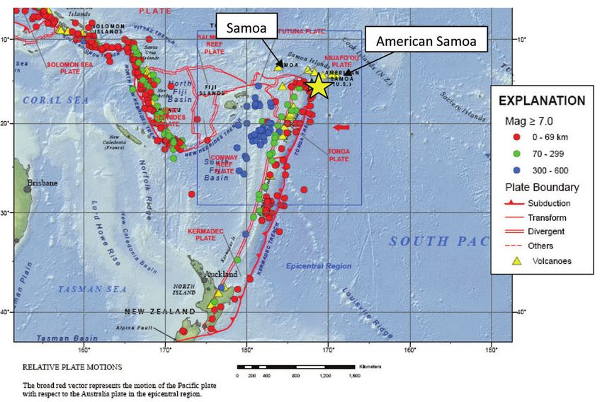
Multiple reconnaissance teams Jennifer Donahue (Geosyntec Con- and 75 km east of Tonga’s Niua
traveled to Samoa in October and sultants) and Michael J. Olsen (Or- Group. The earthquake occurred
November 2009, and contributed egon State University). in a region of high seismicity, with
to the preparation of this report. 14 large earthquakes in the region
A separate team was comprised of
These included EERI member and since the early 1900s. This is the
EERI member Lori Dengler (Hum-
structural engineer Steven Bal- most significant earthquake on the
boldt State University), Kate Long
dridge, president of Baldridge & northern bend of the Tonga trench
(California Emergency Management
Associates Structural Engineering, since 1917 (Okal et al., 2004). The
Agency), Jeff Brandt (California De-
and an International Tsunami Sur- earthquake did not result from sub-
partment of Fish and Game), Heather
vey Team, headed by EERI mem- duction of the Pacific plate into the
Lazrus (University of Oklahoma), and
ber Hermann Fritz of Georgia Tech, Tonga trench (Figure 1), but rather
Lesley Ewing (California Coastal
that covered the entire Samoan from normal faulting expressing a
Commission). This team traveled to
archipelago, including the islands lateral tear in the plate as it slides
Samoa in late October with a team
of Upolu, Savai’i, Manono, Tutuila, past the northern bend of the plate
from the American Society of Civil
Aunu’u, Ofu and Olosega. Other boundary. Such events are known
Engineers.
members of this team were Costas elsewhere (Grovers and Wortel,
Synolakis and Jose Borrero (Uni- The research, publication and distri- 2005), but their recurrence is even
versity of Southern California), bution of this report were funded by more poorly understood than that for
Emile Okal (Northwestern Univer- the EERI Learning from Earthquakes great subduction earthquakes.
sity), Robert Weiss and Patrick Project, under grant # CMMI-0758529
The ensuing tsunami killed nine peo-
Lynett (Texas A&M University), from the U.S. National Science Foun-
ple in Tonga, 149 in the independent
Vasily Titov (NOAA), Bruce Jaffe dation.
country of Samoa, and 34 in Ameri-
(USGS), Spyros Foteinis (Techni-
can Samoa. It was the deadliest tsu-
cal University of Crete), and I-Chi Introduction nami in the Samoa region in living
Chan and Philip L.-F. Liu (Cornell
On September 29, 2009, at 17:48:10 history. The damage in Samoa
University). A survey team from
UTC (local time: UTC-11), an Mw8.1 alone exceeded $150 million. A tsu-
Geo-engineering Extreme Events
earthquake struck about 200 km south nami warning issued by the Pacific
Reconnaissance (GEER) included
of the main Samoan Islands chain Tsunami Warning Center 16 minutes
after the earthquake was too late for
many, since the tsunami arrived in
11-15 minutes at some of the hard-
est hit villages. Fortunately, many
Samoans were aware of tsunamis
and knew to get to high ground after
an earthquake, behavior attributed
to education and evacuation exer-
cises initiated throughout the South
Pacific over the past decade. In-
deed, evacuation exercises had
been conducted in Samoa in the
preceding year, and many schools in
American Samoa practiced monthly
evacuation drills.
Tsunami Field Surveys
Eyewitnesses described between
one and four main waves, with an
initial recession interpreted as a
leading depression N-wave (Tade-
Figure 1. Tectonic setting of the Samoa Islands region (U.S. Geological
palli and Synolakis, 1994).
Survey Earthquake Information Center).
1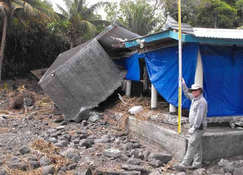
EERI Special Earthquake Report — January 2010

                                                                                           Figure 4. 3D laser scanner setup in
                                                                                           Tula, American Samoa.

                                                                                           The harbor geometry at Pago Pago
                                                                                           amplified the tsunami from just a
                                                                                           few meters at the entrance to 8 m at
                                                                                           the head, causing inundation
                                                                                           and damage more than 500 m in-
  Figure 2. Maximum tsunami runup exceeding 14m at Lepa on Upolu Island,                   land up the Vaipito River. Similar
  Samoa.                                                                                   inundation distances were observed
                                                                                           along the river at Leone in south-
                                                                                           east Tutuila. An eyewitness de-
                                                                                           scribed the flooding at Pago Pago
                                                                                           as much more violent than during
                                                                                           the 1960 Chilean tsunami.
                                                                                           In contrast to Tutuila, which had sig-
                                                                                           nificant tsunami impact on both
                                                                                           north and south coasts, destruction
                                                                                           on Samoa’s Islands was confined to
                                                                                           the southern coasts. This effect, as
                                                                                           well as the location of the highest
                                                                                           runup, can be explained by tsuna-
                                                                                           mi directivity from the source region
                                                                                           that focused wave energy towards
                                                                                           the western tip of Tutuila and SE
                                                                                           Upolu, and radiated less energy
                                                                                           elsewhere. On Upolu, runup
                                                                                           reached 14 m at Lepa (Figure 2),
                                                                                           while on Savai’i maximum runup ex-
                                                                                           ceeded 8 m at Nuu. At nearby Taga,
                                                                                           6 m runup and 200 m of inundation
                                                                                           left a boulder deposit field 100 m
  Figure 3. Tsunami boulder field, wash-out damage and water tank impact at                inland (Figure 3).
  Taga on Savai’i Island, Samoa.
                                                                                           LIDAR
  The measured flow depths and run-             on the central north coast, and 9 m
                                                                                           The use of LIDAR (Light Detection
  up heights indicate extreme and               at Tula in the east.
                                                                                           and Ranging) was important to the
  significant variation on all main is-         Pago Pago on the central south coast       investigation for multiple reasons.
  lands. On Tutuila, maximum runup              represents an unfortunate example of       First, it provided a quick way to
  exceeded 17 m at Poloa, near the              a town and harbor ideal for protection     obtain valuable information before
  western tip. Runup decreased                  against storm waves, but vulnerable        clean-up was done and vegeta-
  somewhat along Tutuila from west              to tsunami (Fritz and Kalligeris, 2008).   tion grew back. Second, although
  to east, reaching 12 m at Fagasa

                                                                   2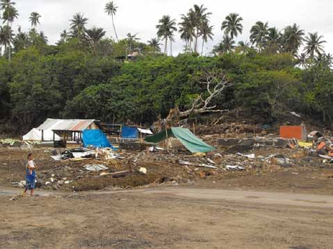
EERI Special Earthquake Report — January 2010

Figure 5. Near Lepa, Samoa. The high water line was              Figure 6. Debris piled up at more than 12 m elevation at
measured at 13.6 meters above sea level here.                    Poloa, American Samoa.

Figure 7. Scouring to a depth of 0.65 m underneath a             Figure 8. In Lepa, Samoa, scour caused the collapse of
large multi-family dwelling in Leone, American Samoa.            part of a village meetinghouse.

no previous data were available,          (Figure 5) was completely destroyed.          of Tutuila Island and has a north-
LIDAR provided high-resolution            From the beachhead inland, there              western exposure. At the time of
data allowing for much more accu-         is a small rise in topography, then a         this report, all remaining residents
rate damage quantification than can       ravine, then a steep hillside. Most           have abandoned Poloa and have
be had from traditional methods.          of the devastation occurred in the            moved into the surrounding hills.
Finally, it allowed for models to be      ravine, which was littered with debris,       Scour: Scour around foundations
available for scientists to study with-   houses and cars. Almost 90% of                was visible at many locations (Fig-
out having to travel to the site.         the structures in this area were              ure 7). It was caused by both the
                                          destroyed.                                    incoming and return waves. Most
A Leica ScanStation 2 laser scanner
was used by the GEER team for the         Of all villages on the island of Ameri-       scour was observed around the
survey. 360o panoramic overview           can Samoa, Poloa sustained the most           foundations of homes, but some
scans were completed for each             damage (Figure 6). All structures             was also observed around utility
setup (Figure 4).                         were destroyed except for the church,         poles.
                                          which sustained heavy damage to               For most of the buildings, even
General Tsunami Damage                    doors, windows and furniture, but             those with relatively shallow foun-
                                          only minor structural damage. The             dations, scour depths did not occur
Widespread damage was seen
                                          sheer cliffs show trim lines up to 17 m.      to an extent that contributed to
throughout Samoa and American
                                          Poloa is located on the western side          structural failure. Scouring was
Samoa. The village of Lepa, Samoa

                                                             3
EERI Special Earthquake Report — January 2010
most prevalent in the villages Lepa,
Alao, Leone, Asili, Poloa, and Tula.
The GEER team used both the
traditional means of measuring tape
and LIDAR to document scour
(Figure 8).
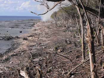
Erosion: Substantial erosional
damage from the tsunami was ob-
served (Figure 9), and additional
erosion and landslides are anticipat-
ed with future precipitation because
of the vegetation destroyed by the
tsunami.
Unfortunately, reference data are
not available for overall quantifica-
tion of the erosion, but by combin-
ing LIDAR data from areas of ero-
sion with an approximation of previ-
ous topography, it is reasonable to
estimate overall quantification of the
erosion.
Figure 9. Wave-induced bluff erosion observed in Aufaga, Samoa.
Figure 10 (a) ▲On Niuatoputapu Island’s north tip: the entire forest was overwhelmed by the tsunami, with stripped
and uprooted trees as well as coral boulders.
(b) ▼The scars on the bark of the tree — at the far right (c) ▼Tafahi Island looking north from the maximum 22 m
in (a) — indicate 9.4 m flow depth above terrain, 6 m runup, with broken branches in the foreground and the
above sea level and 200 m from the beach, with scour of destroyed forest along the beach.
more than 2 m at the roots.
4
EERI Special Earthquake Report — January 2010

Observations in Tonga’s
Niua Group
A follow-up expedition from 23 to 28
November surveyed the three main
islands of Tonga’s northern-most
Niua group. The tsunami impact on
this group surprisingly eclipsed the
Samoan observations in all as-
pects, with maximum runup of 22 m
on both the east and west coasts of
Tafahi Island as well as flow depth
of 15 m and inundation of 1 km on
Niuatoputapu Island’s east coast.
Tafahi represents tsunami impact
on a volcanic island characterized       Figure 11. The damage to the roof of the fale provides evidence of the height
by steep hill slopes (typically 1V:5H)   of the tsunami. The concrete foundation and columns sustained minor damage.
and fringing reefs within 100 m of
the shoreline.                           up the principal, who had already           Many of the low-lying villages have
Niuatoputapu’s flat coastal topogra-     evacuated. An additional Tongan             churches near and facing the
phy and near-shore fringing reefs        victim at Hihifo returned to his house      ocean. The typical construction is
allowed for massive inland penetra-      to close a shop between tsunami             a combination of concrete frames
tion of the tsunami waves along the      waves.                                      and concrete masonry (CMU) infill.
south and east coasts. While for-        Hence only the keeper of the Palm           There were several examples of the
ests may provide some tsunami            Tree Island Resort on Hunganga              tsunami entering churches through
attenuation at flow depths below         Island, which was totally submerged         the front door and flowing out the
5 m, the forests on the south coast      by tsunami waves, was an unprevent-         windows along the sides. While
were completely overwhelmed by           able fatality in the Kingdom of Tonga.      doors, windows, and interior furni-
local flow depths of up to 10 m                                                      ture were damaged, the structures
above ground (Figure 10).                Structural Damage                           did not appear to have any dis-
Fortunately, the coral reefs and ti-                                                 tress from the hydrostatic loading.
                                         Many masonry buildings and rein-            However, the contents of the build-
dal flats extending between 1 and        forced concrete columnar open struc-
2 km offshore reduced the tsunami                                                    ings were either washed from the
                                         tures known as fales appeared to            buildings or strewn about within the
impact along the north shore for         withstand the forces of the tsunami
villages such as Hihifo.                                                             structures, resulting in significant
                                         inundation with only minor structural       financial loss (Figure 12). Some
Seven of the nine victims on Niua-       frame damage. Most of the columnar          foundations failed due to scouring,
toputapu were loaded onto a truck        fales are almost completely open,           but most foundations were found in
caught by the tsunami while head-        allowing the tsunami to flow through        acceptable conditions.
ing back to the high school to pick      them (Figure 11).

Figure 12. Damage around and within the church in the village of Poloa, American Samoa.

                                                            5
EERI Special Earthquake Report — January 2010

  Figure 13 (a). While the windows, doors, and contents of             Figure 13 (b). This CMU residence suffered collapse.
  this CMU residence were destroyed by the tsunami, the                The remaining debris provides evidence that most of the
  structure was relatively intact.                                     CMU cells were not reinforced or grouted.

  While most CMU buildings with-                as vehicles, shipping containers and        agement, environmental science,
  stood the tsunami, those that were            boats.                                      anthropology, emergency manage-
  poorly constructed did not fare well          The structural damage that was ob-          ment, and mitigation. The team
  (Figure 13). Wood-framed and poor-            served appeared to be primarily from        focused on identifying the fac-
  ly reinforced masonry buildings in            the tsunami effects and not from            tors that influenced the impacts of
  most cases were torn completely               strong ground motion during the             the tsunami, and looked at how
  from their foundations (Figures 14            earthquake.                                 coastal land use planning and man-
  and 15).                                                                                  agement, emergency planning and
  Several columnar structures with              Community Impacts                           response, and culture, education
  weak reinforcement were severely                                                          and awareness of tsunami hazards
                                                The interdisciplinary team that visit-      affected outcomes.
  damaged. There was evidence of                ed Samoa and American Samoa in
  damage created by the impact                  late October had expertise in coast-        Human Behavior: All three EERI
  forces of large floating debris such          al and port engineering, coastal man-       teams talked with eyewitnesses to
                                                                                            the tsunami. Most people were
                                                                                            aware of tsunami hazards and had
                                                                                            heard that earthquake ground
                                                                                            shaking was a natural warning, but
                                                                                            many reported evacuating only
                                                                                            after watching others do so or once
                                                                                            they saw the water withdraw. A
                                                                                            number of communities used in-
                                                                                            formal community notification sys-
                                                                                            tems such as church and school
                                                                                            bells (Figure 16).
                                                                                            Several victims perished during
                                                                                            the evacuation while inside cars;
                                                                                            this may be attributed to conflicting
                                                                                            official statements issued in Samoa
                                                                                            on the use of vehicles during a
                                                                                            tsunami evacuation.
                                                                                            Factors that reduced impacts:
                                                                                            •   Time of day: The tsunami oc-
                                                                                                curred early enough in the day
  Figure 14. The lower floor of this two-story wood frame residence was                         that few were at work or on the
  destroyed by the tsunami.                                                                     road, but late enough so that

                                                                   6
EERI Special Earthquake Report — January 2010

Figure 15. This single-story wood frame residence collapsed completely.

    everyone was awake. Many             •   Village structure provided shelter         Figure 16. Church bell at Poutasi,
    people were outside just getting         and high ground: There were no             Samoa. The bells serve to notify
    ready to go to work or school            tent cities of evacuees. All villages      community members of church
    and in good positions to see the         include both high and low ground           times and other events, and were
    water drawdown.                          and the family ties assured that no        also used in some communities by
•   Little earthquake damage:                one was isolated or left alone.            pastors and others to warn people
    Shaking damage was minimal           Factors that exacerbated impacts:              about the tsunami.
    and did not disrupt roads or         •   A very large near-source tsunami
    structures.                              with first wave arrivals before any            Tsunami hazard zone signs had
•   First significant wave a drawdown        official warning could be issued.              been posted in American Sam-
                                                                                            oa but there were no visual sig-
•   Availability of high ground: In      •   Most people required at least two              nals as to how high was high
    American Samoa, almost all vul-          indications that they were at risk             enough. There were no marked
    nerable coastal areas were in            before they evacuated; very few                evacuation routes with direction
    close proximity to high ground.          people responded to the ground                 and distance to tsunami safe
•   Tsunami awareness: Most peo-             shaking alone. The most common                 areas and shelters.
    ple were aware of tsunamis. In           combination was feeling the earth-
                                             quake and seeing the water with-           •   Many people drove.
    American Samoa, September
    was emergency preparedness               draw. Other additional indicators          •   Lack of awareness that there
    month, and a number of projects          included hearing a bell or siren, or           could be more than one wave.
    targeted tsunamis funded                 the alerting of neighbors.                 •   Embarrassment: young people
    through the TsunamiReady pro-        •   Confusion about where to go.                   were aware that ground shak-
    gram, including showing videos
    of the 2004 Indian Ocean tsuna-
    mi. Although aware, many peo-
    ple did not expect it was some-
    thing that could happen in Sam-
    oa. Some schools practiced
    regular tsunami evacuation drills.
•   Altruism: Many people put them-
    selves in harm’s way to save
    others.
•   Rapid cleanup.
•   Strong 2-3 story buildings pro-
    vided vertical evacuation.           Figure 17. Poutasi, Samoa. Inland lagoons and water bodies that wrap be-
                                         hind coastal communities exacerbate their vulnerability by cutting off evacu-
•   Coastal protection structures        ation. Other land forms and built structures, such as steep terrain and pig
    generally performed well.            styes, had the same effect.

                                                             7
EERI Special Earthquake Report — January 2010

                                                • Develop a protocol to assess the        Thanks go to Don Vargo, Marie
                                                  vulnerability of coastal villages,      Can-Kau, Sharon Fanolua and
                                                  including exposure to tsunamis,         Agnes Vargo of American Samoa
                                                  evacuation procedures, access to        Community College for assistance
                                                  evacuation sites on high ground or      with logistics, translation, and shar-
                                                  inland away from the coast, land        ing their insights; Tisa Fa’amuli,
                                                  use (shoreline protection features,     Candy Mann, Eti Sapolu, and Me
                                                  vegetation), barriers to evacua-        Sapolu for lodging and logistical
                                                  tion such as rivers and mangrove        assistance, translation and discus-
                                                  swamps, and other hazards in the        sion; Joe Toland of FEMA for shar-
                                                  area such as landslides, and hur-       ing his geospatial images; Laura
                                                  ricanes                                 Kong and Brian Yanagi of the
                                                •   Chronicle the recovery process        International Tsunami Informa-
                                                    over time in terms of rebuilding,     tion Center for logistical help and
                                                    use of devastated areas, institu-     coordination with other Interna-
                                                    tionalizing tsunami warning, evac-    tional Tsunami Survey Teams; Jan
                                                    uation procedures, education and      Steffan of UNESCO for facilitating
                                                    outreach, role of village cultural    the work in Samoa; Ausitalia of the
                                                    structures (matai, faife’au, etc.),   Ministry of Natural Resources and
                                                    and memorials of the event.           the Environment for the Samoan
  Figure 18. The mayor of Amenave                                                         Government for providing an inter-
  had attended a workshop for village           •   Build on traditional village struc-   preter and guidance, and all of the
  mayors on tsunami hazards. When                   ture to promote resiliency. Incor-    people who shared their stories.
  he felt the earthquake, he grabbed                porating tsunami safety into vil-
                                                    lage pride may sustain community      The GEER team also wishes to
  his bullhorn and ran through the
                                                    efforts. Consider the one-year        acknowledge the support of David
  village notifying people to evacuate.
                                                    anniversary of the tsunami as an      Evans and Associates, Inc. for
                                                    opportunity for villages to develop   providing the 3D laser scanner and
      ing was a sign of an impending                evacuation routes and practice        equipment on very short notice;
      tsunami but were worried that                 drills.                               Jim Griffis and Marcus Reedy, who
      other people would think they                                                       made the necessary arrangements;
      were silly if they evacuated.             • Examine informal warning sys-           and Yumei Wang, Harry Yeh, the
                                                  tems such as bells, private sirens,     entire GEER steering committee,
  •   Infrastructure that could not re-           and bull horns (Figure 18), and
      sist uplift forces. Bridges were                                                    and Bruce Jaffe of the U.S. Geolog-
                                                  develop criteria to support their       ical Survey for their administrative,
      particularly vulnerable to buoy-            use for near-source tsunami
      ancy forces.                                                                        technical and logistical support.
                                                  events.                                 They also extend thanks to Leica
  •   Barriers to evacuation. A number
                                                                                          Geosytems for providing licenses
      of communities had difficulty             Acknowledgements                          for the Cyclone software.
      with access to high ground be-
      cause of rivers or mangrove               Steven Baldridge’s participation in
      swamps that isolated coastal              the field investigation was funded by     References
      areas, landslides, fences, and in         the EERI Learning from Earthquakes
      one case, pig styes (Figure 17).          Program sponsored by the National         Fritz, H. M. and N. Kalligeris,
                                                Science Foundation. The Interna-              2008. Geophys. Res. Lett., 35,
                                                tional Tsunami Survey Team was sup-           L01607.
  Recommendations                               ported by an NSF Rapid Response           Govers, R. and M.J.R. Wortel,
  •   Develop credible tsunami/multi-           Research award. A grant from the            2005. Earth Plan. Sci. Letts., v.
      hazard maps for all low-lying             NSF-sponsored Geo-engineering               236, pp. 505-523.
      communities based on likely               Extreme Events Reconnaissance
      sources, both nearby and else-            Association provided core support         Okal, E.A. et al., 2004. Geophysical
      where in the Pacific, delineating         for the GEER participants. Financial        J. Int. 157, 164-174.
      evacuation zones, routes, and             support for the team that traveled to     Tadepalli, S. and C.E. Synolakis,
      safe areas. Signs can indicate            Samoa in late October was provided           1994. Proceedings: Mathemati-
      the hazard zones once they are            by EERI, the California State Lands          cal and Physical Sciences, 445
      defined, and educational efforts          Commission, ASCE, and donations to           (1923): 99-112.
      can be developed.                         the Humboldt State University Spon-
                                                sored Program Foundation.

                                                                    8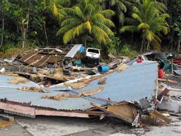
You can also read