SATELLITE REMOTE SENSING AND GIS APPLICATIONS IN AGRICULTURAL METEO-ROLOGY AND WMO SATELLITE ACTIVITIES
←
→
Page content transcription
If your browser does not render page correctly, please read the page content below
SATELLITE REMOTE SENSING AND GIS
APPLICATIONS IN AGRICULTURAL METEO-
ROLOGY AND WMO SATELLITE ACTIVITIES

M.V.K. Sivakumar and Donald E. Hinsman
Agricultural Meteorology Division and Satellite Activities Office
World Meteorological Organization (WMO), 7bis Avenue de la Paix,
1211 Geneva 2, Switzerland

       Abstract : Agricultural planning and use of agricultural technologies need
       applications of agricultural meteorology. Satellite remote sensing technology is
       increasingly gaining recognition as an important source of agrometeorological data
       as it can complement well the traditional methods agrometeorological data
       collection. Agrometeorologists all over the world are now able to take advantage
       of a wealth of observational data, product and services flowing from specially
       equipped and highly sophisticated environmental observation satellites. In addition,
       Geographic Information Systems (GIS) technology is becoming an essential tool
       for combining various map and satellite information sources in models that simulate
       the interactions of complex natural systems. The Commission for Agricultural
       Meteorology of WMO has been active in the area of remote sensing and GIS
       applications in agrometeorology. The paper provides a brief overview of the satellite
       remote sensing and GIS Applications in agricultural meteorology along with a
       description of the WMO Satellite Activities Programme. The promotion of new
       specialised software should make the applications of the various devices easier,
       bearing in mind the possible combination of several types of inputs such as data
       coming from standard networks, radar and satellites, meteorological and
       climatological models, digital cartography and crop models based on the scientific
       acquisition of the last twenty years.

INTRODUCTION

    Agricultural planning and use of agricultural technologies need application
of agricultural meteorology. Agricultural weather and climate data systems are
necessary to expedite generation of products, analyses and forecasts that affect

Satellite Remote Sensing and GIS Applications in Agricultural Meteorology
pp. 1-21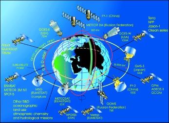
2         Satellite Remote Sensing and GIS Applications in Agricultural Meteorology

agricultural cropping and management decisions, irrigation scheduling,
commodity trading and markets, fire weather management and other
preparedness for calamities, and ecosystem conservation and management.

     Agrometeorological station networks are designed to observe the data of
meteorological and biological phenomena together with supplementary data
as disasters and crop damages occur. The method of observation can be
categorized into two major classes, manually observed and automatic weather
stations (AWS). A third source for agrometeorological data that is gaining
recognition for its complementary nature to the traditional methods is satellite
remote sensing technology.

    Remotely sensed data and AWS systems provide in many ways an
enhanced and very feasible alternative to manual observation with a very short
time delay between data collection and transmission. In certain countries where
only few stations are in operation as in Northern Turkmenistan (Seitnazarov,
1999), remotely sensed data can improve information on crop conditions for
an early warning system. Due to the availability of new tools, such as
Geographic Information Systems (GIS), management of an incredible quantity
of data such as traditional digital maps, database, models etc., is now possible.
The advantages are manifold and highly important, especially for the fast cross-
sector interactions and the production of synthetic and lucid information for
decision-makers. Remote sensing provides the most important informative
contribution to GIS, which furnishes basic informative layers in optimal time
and space resolutions.

    In this paper, a brief overview of the satellite remote sensing and GIS
applications in agricultural meteorology is presented along with a description
of the WMO Satellite Activities Programme. Details of the various applications
alluded to briefly in this paper, can be found in the informative papers
prepared by various experts who will be presenting them in the course of this
workshop.

The Commission for Agricultural Meteorology (CAgM) of WMO, Remote
Sensing and GIS

    Agricultural meteorology had always been an important component of the
National Meteorological Services since their inception. A formal Commission
for Agricultural Meteorology (CAgM) which was appointed in 1913 by the
International Meteorological Organization (IMO), became the foundation of
the CAgM under WMO in 1951.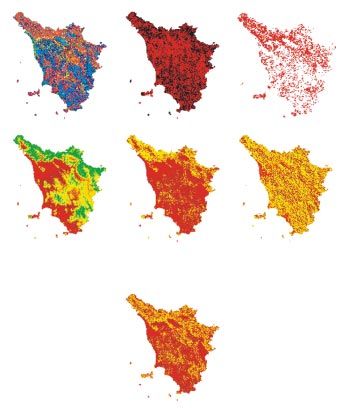
M.V.K. Sivakumar and Donald E. Hinsman                                           3

    The WMO Agricultural Meteorology Programme is coordinated by
CAgM. The Commission is responsible for matters relating to applications of
meteorology to agricultural cropping systems, forestry, and agricultural land
use and livestock management, taking into account meteorological and
agricultural developments both in the scientific and practical fields and the
development of agricultural meteorological services of Members by transfer of
knowledge and methodology and by providing advice.

     CAgM recognized the potential of remote sensing applications in
agricultural meteorology early in the 70s and at its sixth session in Washington
in 1974 the Commission agreed that its programme should include studies
on the application of remote sensing techniques to agrometeorological problems
and decided to appoint a rapporteur to study the existing state of the
knowledge of remote sensing techniques and to review its application to
agrometeorological research and services. At its seventh session in Sofia, Bulgaria
in 1979, the Commission reviewed the report submitted by Dr A.D.
Kleschenko (USSR) and Dr J.C. Harlan Jr (USA) and noted that there was a
promising future for the use in agrometeorology of data from spacecraft and
aircraft and that rapid progress in this field required exchange of information
on achievements in methodology and data collection and interpretation. The
Commission at that time noted that there was a demand in almost all countries
for a capability to use satellite imagery in practical problems of agrometeorology.
The Commission continued to pay much attention to both remote sensing
and GIS applications in agrometeorology in all its subsequent sessions up to
the 13th session held in Ljubljana, Slovenia in 2002. Several useful publications
including Technical Notes and CAgM Reports were published covering the
use of remote sensing for obtaining agrometeorological information
(Kleschenko, 1983), operational remote sensing systems in agriculture
(Kanemasu and Filcroft, 1992), satellite applications to agrometeorology and
technological developments for the period 1985-89 (Seguin, 1992), statements
of guidance regarding how well satellite capabilities meet WMO user
requirements in agrometeorology (WMO, 1998, 2000) etc. At the session in
Slovenia in 2002, the Commission convened an Expert Team on Techniques
(including Technologies such as GIS and Remote Sensing) for Agroclimatic
Characterization and Sustainable Land Management.

     The Commission also recognized that training of technical personnel to
acquire, process and interpret the satellite imagery was a major task. It was
felt that acquisition of satellite data was usually much easier than the
interpretation of data for specific applications that were critical for the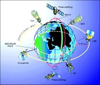
4         Satellite Remote Sensing and GIS Applications in Agricultural Meteorology

assessment and management of natural resources. In this regard, the
Commission pointed out that long-term planning and training of technical
personnel was a key ingredient in ensuring full success in the use of current
and future remote sensing technologies that could increase and sustain
agricultural production, especially in the developing countries. In this
connection, WMO already organized a Training Seminar on GIS and
Agroecological Zoning in Kuala Lumpur, Malaysia in May 2000 in which six
participants from Malaysia and 12 from other Asian and the South-West Pacific
countries participated. The programme for the seminar dealt with
meteorological and geographical databases, statistical analyses, spatialization,
agro-ecological classification, overlapping of agroecological zoning with
boundary layers, data extraction, monitoring system organization and bulletins.

    The training workshop currently being organized in Dehradun is in
response to the recommendations of the Commission session in Slovenia in
2002 and it should help the participants from the Asian countries in learning
new skills and updating their current skills in satellite remote sensing and
GIS applications in agricultural meteorology.

GIS APPLICATIONS IN AGROMETEOROLOGY

    A GIS generally refers to a description of the characteristics and tools used
in the organization and management of geographical data. The term GIS is
currently applied to computerised storage, processing and retrieval systems
that have hardware and software specially designed to cope with geographically
referenced spatial data and corresponding informative attribute. Spatial data
are commonly in the form of layers that may depict topography or
environmental elements. Nowadays, GIS technology is becoming an essential
tool for combining various map and satellite information sources in models
that simulate the interactions of complex natural systems. A GIS can be used
to produce images, not just maps, but drawings, animations, and other
cartographic products.

    The increasing world population, coupled with the growing pressure on
the land resources, necessitates the application of technologies such as GIS to
help maintain a sustainable water and food supply according to the
environmental potential. The “sustainable rural development” concept envisages
an integrated management of landscape, where the exploitation of natural
resources, including climate, plays a central role. In this context,
agrometeorology can help reduce inputs, while in the framework of global
M.V.K. Sivakumar and Donald E. Hinsman 5
change, it helps quantify the contribution of ecosystems and agriculture to
carbon budget (Maracchi, 1991). Agroclimatological analysis can improve the
knowledge of existing problems allowing land planning and optimization of
resource management. One of the most important agroclimatological
applications is the climatic risk evaluation corresponding to the possibility that
certain meteorological events could happen, damaging crops or infrastructure.
At the national and local level, possible GIS applications are endless. For
example, agricultural planners might use geographical data to decide on the
best zones for a cash crop, combining data on soils, topography, and rainfall
to determine the size and location of biologically suitable areas. The final
output could include overlays with land ownership, transport, infrastructure,
labour availability, and distance to market centres.
The ultimate use of GIS lies in its modelling capability, using real world
data to represent natural behaviour and to simulate the effect of specific
processes. Modelling is a powerful tool for analyzing trends and identifying
factors that affect them, or for displaying the possible consequences of human
activities that affect the resource availability.
In agrometeorology, to describe a specific situation, we use all the
information available on the territory: water availability, soil types, forest and
grasslands, climatic data, geology, population, land-use, administrative
boundaries and infrastructure (highways, railroads, electricity or
communication systems). Within a GIS, each informative layer provides to
the operator the possibility to consider its influence to the final result. However
more than the overlap of the different themes, the relationship of the numerous
layers is reproduced with simple formulas or with complex models. The final
information is extracted using graphical representation or precise descriptive
indexes.
In addition to classical applications of agrometeorology, such as crop yield
forecasting, uses such as those of the environmental and human security are
becoming more and more important. For instance, effective forest fire
prevention needs a series of very detailed information on an enormous scale.
The analysis of data, such as the vegetation coverage with different levels of
inflammability, the presence of urban agglomeration, the presence of roads
and many other aspects, allows the mapping of the areas where risk is greater.
The use of other informative layers, such as the position of the control points
and resource availability (staff, cars, helicopters, aeroplanes, fire fighting6 Satellite Remote Sensing and GIS Applications in Agricultural Meteorology
equipment, etc.), can help the decision-makers in the management of the
ecosystems. Monitoring the resources and the meteorological conditions
therefore allows, the consideration of the dynamics of the system, with more
adherence to reality. For instance, Figure 1 shows the informative layers used
for the evaluation of fire risk in Tuscany (Italy). The final map is the result of
the integration of satellite data with territorial data, through the use of
implemented GIS technologies (Romanelli et al., 1998).
Land use Distance road Starting point
Quota Slope Aspect
Fire risk
Figure 1. Informative layers for the evaluation of fire risk index (Maracchi et al., 2000).M.V.K. Sivakumar and Donald E. Hinsman 7
These maps of fire risk, constitute a valid tool for foresters and for
organisation of the public services. At the same time, this new informative
layer may be used as the base for other evaluations and simulations. Using
meteorological data and satellite real-time information, it is possible to diversify
the single situations, advising the competent authorities when the situation
moves to hazard risks. Modelling the ground wind profile and taking into
account the meteorological conditions, it is possible to advise the operators
of the change in the conditions that can directly influence the fire, allowing
the modification of the intervention strategies.
An example of preliminary information system to country scale is given
by the SISP (Integrated information system for monitoring cropping season
by meteorological and satellite data), developed to allow the monitoring of
the cropping season and to provide an early warning system with useful
information about evolution of crop conditions (Di Chiara and Maracchi,
1994). The SISP uses:
z Statistical analysis procedures on historical series of rainfall data to produce
agroclimatic classification;
z A crop (millet) simulation model to estimate millet sowing date and to
evaluate the effect of the rainfall distribution on crop growth and yield;
z NOAA-NDVI image analysis procedures in order to monitor vegetation
condition;
z Analysis procedures of Meteosat images of estimated rainfall for early
prediction of sowing date and risk areas.
The results of SISP application shown for Niger (Fig. 2) are charts and
maps, which give indications to the expert of the millet conditions during
the season in Niger, with the possibility to estimate the moment of the harvest
and final production. SISP is based on the simulation of the millet growth
and it gives an index of annual productivity by administrative units. These
values, multiplied to a yield statistical factor, allow estimation of absolute
production.
By means of such systems based on modelling and remote sensing, it is
possible to extract indices relative to the main characteristics of the agricultural
season and conditions of natural systems. This system is less expensive, easily
transferable and requires minor informative layers, adapting it to the specific
requirements of the users.8 Satellite Remote Sensing and GIS Applications in Agricultural Meteorology
Niamey, cropping season 1993
Characterization of land productivity at Niger
CeSIA Index for miller
Elaborated on 10 years (1981-90) and 120 stations
Rainfall Cultural Coeff. Water balance
Longitude
Figure 2. Examples of outputs of SISP (Maracchi et al., 2000).
SATELLITE REMOTE SENSING
Remote sensing provides spatial coverage by measurement of reflected and
emitted electromagnetic radiation, across a wide range of wavebands, from the
earth’s surface and surrounding atmosphere. The improvement in technical
tools of meteorological observation, during the last twenty years, has created
a favourable substratum for research and monitoring in many applications of
sciences of great economic relevance, such as agriculture and forestry. Each
waveband provides different information about the atmosphere and land
surface: surface temperature, clouds, solar radiation, processes of photosynthesis
and evaporation, which can affect the reflected and emitted radiation, detected
by satellites. The challenge for research therefore is to develop new systems
extracting this information from remotely sensed data, giving to the final users,
near-real-time information.
Over the last two decades, the development of space technology has led
to a substantial increase in satellite earth observation systems. Simultaneously,
the Information and Communication Technology (ICT) revolution has rendered
increasingly effective the processing of data for specific uses and their
instantaneous distribution on the World Wide Web (WWW).
The meteorological community and associated environmental disciplines
such as climatology including global change, hydrology and oceanography all
over the world are now able to take advantage of a wealth of observational
data, products and services flowing from specially equipped and highly
sophisticated environmental observation satellites. An environmentalM.V.K. Sivakumar and Donald E. Hinsman 9
observation satellite is an artificial Earth satellite providing data on the Earth
system and a Meteorological satellite is a type of environmental satellite
providing meteorological observations. Several factors make environmental
satellite data unique compared with data from other sources, and it is worthy
to note a few of the most important:
z Because of its high vantage point and broad field of view, an environmental
satellite can provide a regular supply of data from those areas of the globe
yielding very few conventional observations;
z The atmosphere is broadly scanned from satellite altitude and enables large-
scale environmental features to be seen in a single view;
z The ability of certain satellites to view a major portion of the atmosphere
continually from space makes them particularly well suited for the
monitoring and warning of short-lived meteorological phenomena; and
z The advanced communication systems developed as an integral part of
the satellite technology permit the rapid transmission of data from the
satellite, or their relay from automatic stations on earth and in the
atmosphere, to operational users.
These factors are incorporated in the design of meteorological satellites to
provide data, products and services through three major functions:
z Remote sensing of spectral radiation which can be converted into
meteorological measurements such as cloud cover, cloud motion vectors,
surface temperature, vertical profiles of atmospheric temperature, humidity
and atmospheric constituents such as ozone, snow and ice cover, ozone
and various radiation measurements;
z Collection of data from in situ sensors on remote fixed or mobile platforms
located on the earth’s surface or in the atmosphere; and
z Direct broadcast to provide cloud-cover images and other meteorological
information to users through a user-operated direct readout station.
The first views of earth from space were not obtained from satellites but
from converted military rockets in the early 1950s. It was not until 1 April
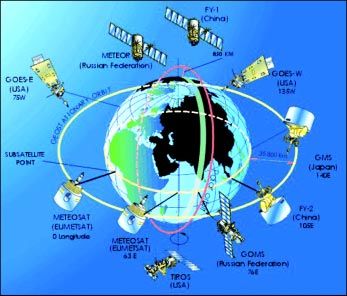
1960 that the first operational meteorological satellite, TIROS-I, was launched10 Satellite Remote Sensing and GIS Applications in Agricultural Meteorology by the USA and began to transmit basic, but very useful, cloud imagery. This satellite was such an effective proof of concept that by 1966 the USA had launched a long line of operational polar satellites and its first geostationary meteorological satellite. In 1969 the USSR launched the first of a series of polar satellites. In 1977 geostationary meteorological satellites were also launched and operated by Japan and by the European Space Agency (ESA). Thus, within 18 years of the first practical demonstration by TIROS-I, a fully operational meteorological satellite system (Fig. 3) was in place, giving routine data coverage of most of the planet. This rapid evolution of a very expensive new system was unprecedented and indicates the enormous value of these satellites to meteorology and society. Some four decades after the first earth images, new systems are still being designed and implemented, illustrating the continued and dynamic interest in this unique source of environmental data. Figure 3: Nominal configuration of the space-based sub-system of the Global Observing System in 1978.
M.V.K. Sivakumar and Donald E. Hinsman                                            11

    By the year 2000, WMO Members contributing to the space-based sub-
system of the Global Observing System had grown. There were two major
constellations in the space-based Global Observing System (GOS) (Fig. 4).
One constellation was the various geostationary satellites, which operated in
an equatorial belt and provided a continuous view of the weather from roughly
70°N to 70°S. The second constellation in the current space-based GOS
comprised the polar-orbiting satellites operated by the Russian Federation,
the USA and the People’s Republic of China. The METEOR-3 series has been
operated by the Russian Federation since 1991.

Figure 4: Nominal configuration of the space-based sub-system of the Global Observing
System in 2000.

    The ability of geostationary satellites to provide a continuous view of
weather systems make them invaluable in following the motion, development,
and decay of such phenomena. Even such short-term events such as severe
thunderstorms, with a life-time of only a few hours, can be successfully
recognized in their early stages and appropriate warnings of the time and area
12 Satellite Remote Sensing and GIS Applications in Agricultural Meteorology
of their maximum impact can be expeditiously provided to the general public.
For this reason, its warning capability has been the primary justification for
the geostationary spacecraft. Since 71 per cent of the Earth’s surface is water
and even the land areas have many regions which are sparsely inhabited, the
polar-orbiting satellite system provides the data needed to compensate the
deficiencies in conventional observing networks. Flying in a near-polar orbit,
the spacecraft is able to acquire data from all parts of the globe in the course
of a series of successive revolutions. For these reasons the polar-orbiting satellites
are principally used to obtain: (a) daily global cloud cover; and (b) accurate
quantitative measurements of surface temperature and of the vertical variation
of temperature and water vapour in the atmosphere. There is a distinct
advantage in receiving global data acquired by a single set of observing sensors.
Together, the polar-orbiting and geostationary satellites constitute a truly global
meteorological satellite network.
Satellite data provide better coverage in time and in area extent than any
alternative. Most polar satellite instruments observe the entire planet once or
twice in a 24-hour period. Each geostationary satellite’s instruments cover
about ¼ of the planet almost continuously and there are now six geostationary
satellites providing a combined coverage of almost 75%. Satellites cover the
world’s oceans (about 70% of the planet), its deserts, forests, polar regions,
and other sparsely inhabited places. Surface winds over the oceans from satellites
are comparable to ship observations; ocean heights can be determined to a
few centimetres; and temperatures in any part of the atmosphere anywhere
in the world are suitable for computer models. It is important to make
maximum use of this information to monitor our environment. Access to these
satellite data and products is only the beginning. In addition, the ability to
interpret, combine, and make maximum use of this information must be an
integral element of national management in developed and developing
countries.
The thrust of the current generation of environmental satellites is aimed
primarily at characterizing the kinematics and dynamics of the atmospheric
circulation. The existing network of environmental satellites, forming part of
the GOS of the World Weather Watch produces real-time weather information
on a regular basis. This is acquired several times a day through direct broadcast
from the meteorological satellites by more than 1,300 stations located in 125
countries.M.V.K. Sivakumar and Donald E. Hinsman 13
The ground segment of the space-based component of the GOS should
provide for the reception of signals and DCP data from operational satellites
and/or the processing, formatting and display of meaningful environmental
observation information, with a view to further distributing it in a convenient
form to local users, or over the GTS, as required. This capability is normally
accomplished through receiving and processing stations of varying complexity,
sophistication and cost.
In addition to their current satellite programmes in polar and geostationary
orbits, satellite operators in the USA (NOAA) and Europe (EUMETSAT) have
agreed to launch a series of joint polar-orbiting satellites (METOP) in 2005.
These satellites will complement the existing global array of geostationary
satellites that form part of the Global Observing System of the World
Meteorological Organization. This Initial Joint Polar System (IJPS) represents
a major cooperation programme between the USA and Europe in the field of
space activities. Europe has invested 2 billion Euros in a low earth orbit satellite
system, which will be available operationally from 2006 to 2020.
The data provided by these satellites will enable development of
operational services in improved temperature and moisture sounding for
numerical weather prediction (NWP), tropospheric/stratospheric interactions,
imagery of clouds and land/ocean surfaces, air-sea interactions, ozone and other
trace gases mapping and monitoring, and direct broadcast support to
nowcasting. Advanced weather prediction models are needed to assimilate
satellite information at the highest possible spatial and spectral resolutions.
It imposes new requirements on the precision and spectral resolution of
soundings in order to improve the quality of weather forecasts. Satellite
information is already used by fishery-fleets on an operational basis. Wind
and the resulting surface stress is the major force for oceanic motions. Ocean
circulation forecasts require the knowledge of an accurate wind field. Wind
measurements from space play an increasing role in monitoring of climate
change and variability. The chemical composition of the troposphere is
changing on all spatial scales. Increases in trace gases with long atmospheric
residence times can affect the climate and chemical equilibrium of the Earth/
Atmosphere system. Among these trace gases are methane, nitrogen dioxide,
and ozone. The chemical and dynamic state of the stratosphere influence the
troposphere by exchange processes through the tropopause. Continuous
monitoring of ozone and of (the main) trace gases in the troposphere and the
stratosphere is an essential input to the understanding of the related
atmospheric chemistry processes.14 Satellite Remote Sensing and GIS Applications in Agricultural Meteorology
WMO SPACE PROGRAMME
The World Meteorological Organization, a specialized agency of the United
Nations, has a membership of 187 states and territories (as of June 2003).
Amongst the many programmes and activities of the organization, there are
three areas which are particularly pertinent to the satellite activities:
z To facilitate world-wide cooperation in the establishment of networks for
making meteorological, as well as hydrological and other geophysical
observations and centres to provide meteorological services;
z To promote the establishment and maintenance of systems for the rapid
exchange of meteorological and related information;
z To promote the standardization of meteorological observations and ensure
the uniform publication of observations and statistics.
The Fourteenth WMO Congress, held in May 2003, initiated a new Major
Programme, the WMO Space Programme, as a cross-cutting programme to
increase the effectiveness and contributions from satellite systems to WMO
Programmes. Congress recognized the critical importance for data, products
and services provided by the World Weather Watch’s (WWW) expanded space-
based component of the Global Observing System (GOS) to WMO
Programmes and supported Programmes. During the past four years, the use
by WMO Members of satellite data, products and services has experienced
tremendous growth to the benefit of almost all WMO Programmes and
supported Programmes. The decision by the fifty-third Executive Council to
expand the space-based component of the Global Observing System to include
appropriate R&D environmental satellite missions was a landmark decision
in the history of WWW. Congress agreed that the Commission for Basic
Systems (CBS) should continue the lead role in full consultation with the other
technical commissions for the new WMO Space Programme. Congress also
decided to establish WMO Consultative Meetings on High-level Policy on
Satellite Matters. The Consultative Meetings will provide advice and guidance
on policy-related matters and maintain a high level overview of the WMO
Space Programme. The expected benefits from the new WMO Space
Programme include an increasing contribution to the development of the
WWW’s GOS, as well as to the other WMO-supported programmes and
associated observing systems through the provision of continuously improved
data, products and services, from both operational and R&D satellites, andM.V.K. Sivakumar and Donald E. Hinsman 15
to facilitate and promote their wider availability and meaningful utilization
around the globe.
The main thrust of the WMO Space Programme Long-term Strategy is:
“To make an increasing contribution to the development of the WWW’s
GOS, as well as to the other WMO-supported Programmes and associated
observing systems (such as AREP’s GAW, GCOS, WCRP, HWR’s WHYCOS
and JCOMM’s implementation of GOS) through the provision of continuously
improved data, products and services, from both operational and R&D
satellites, and to facilitate and promote their wider availability and meaningful
utilization around the globe”.
The main elements of the WMO Space Programme Long-term Strategy
are as follows:
(a) Increased involvement of space agencies contributing, or with the
potential to contribute to, the space-based component of the GOS;
(b) Promotion of a wider awareness of the availability and utilization of
data, products - and their importance at levels 1, 2, 3 or 4 - and
services, including those from R&D satellites;
(c) Considerably more attention to be paid to the crucial problems
connected with the assimilation of R&D and new operational data
streams in nowcasting, numerical weather prediction systems,
reanalysis projects, monitoring climate change, chemical composition
of the atmosphere, as well as the dominance of satellite data in some
cases;
(d) Closer and more effective cooperation with relevant international
bodies;
(e) Additional and continuing emphasis on education and training;
(f ) Facilitation of the transition from research to operational systems;
(g) Improved integration of the space component of the various observing
systems throughout WMO Programmes and WMO-supported
Programmes;16 Satellite Remote Sensing and GIS Applications in Agricultural Meteorology
(h) Increased cooperation amongst WMO Members to develop common
basic tools for utilization of research, development and operational
remote sensing systems.
Coordination Group for Meteorological Satellites (CGMS)
In 1972 a group of satellite operators formed the Co-ordination of
Geostationary Meteorological Satellites (CGMS) that would be expanded in
the early 1990s to include polar-orbiting satellites and changed its name -
but not its abbreviation - to the Co-ordination Group for Meteorological
Satellites. The Co-ordination Group for Meteorological Satellites (CGMS)
provides a forum for the exchange of technical information on geostationary
and polar orbiting meteorological satellite systems, such as reporting on current
meteorological satellite status and future plans, telecommunication matters,
operations, inter-calibration of sensors, processing algorithms, products and
their validation, data transmission formats and future data transmission
standards.
Since 1972, the CGMS has provided a forum in which the satellite
operators have studied jointly with the WMO technical operational aspects
of the global network, so as to ensure maximum efficiency and usefulness
through proper coordination in the design of the satellites and in the
procedures for data acquisition and dissemination.
Membership of CGMS
The table of members shows the lead agency in each case. Delegates are often
supported by other agencies, for example, ESA (with EUMETSAT), NASDA
(with Japan) and NASA (with NOAA).
The current Membership of CGMS is:
EUMETSAT joined 1987
currently CGMS Secretariat
India Meteorological Department joined 1979
Japan Meteorological Agency founder member, 1972
China Meteorological Administration joined 1989
NOAA/NESDIS founder member, 1972
Hydromet Service of the Russian Federation joined 1973M.V.K. Sivakumar and Donald E. Hinsman 17
WMO joined 1973
IOC of UNESCO joined 2000
NASA joined 2002
ESA joined 2002
NASDA joined 2002
Rosaviakosmos joined 2002
WMO, in its endeavours to promote the development of a global
meteorological observing system, participated in the activities of CGMS from
its first meeting. There are several areas where joint consultations between the
satellite operators and WMO are needed. The provision of data to
meteorological centres in different parts of the globe is achieved by means of
the Global Telecommunication System (GTS) in near-real-time. This
automatically involves assistance by WMO in developing appropriate code
forms and provision of a certain amount of administrative communications
between the satellite operators.
WMO’s role within CGMS would be to state the observational and system
requirements for WMO and supported programmes as they relate to the
expanded space-based components of the GOS, GAW, GCOS and WHYCOS.
CGMS satellite operators would make their voluntary commitments to meet
the stated observational and system requirements. WMO would, through its
Members, strive to provide CGMS satellite operators with operational and pre-
operational evaluations of the benefit and impacts of their satellite systems.
WMO would also act as a catalyst to foster direct user interactions with the
CGMS satellite operators through available means such as conferences,
symposia and workshops.
The active involvement of WMO has allowed the development and
implementation of the operational ASDAR system as a continuing part of the
Global Observing System. Furthermore, the implementation of the IDCS
system was promoted by WMO and acted jointly with the satellite operators
as the admitting authority in the registration procedure for IDCPs.
The expanded space-based component of the world weather watch’s global
observing system
Several initiatives since 2000 with regard to WMO satellite activities have
culminated in an expansion of the space-based component of the Global18 Satellite Remote Sensing and GIS Applications in Agricultural Meteorology
Observing System to include appropriate Research and Development (R&D)
satellite missions. The recently established WMO Consultative Meetings on
High-Level Policy on Satellite Matters have acted as a catalyst in each of these
interwoven and important areas. First was the establishment of a new series
of technical documents on the operational use of R&D satellite data. Second
was a recognition of the importance of R&D satellite data in meeting WMO
observational data requirements and the subsequent development of a set of
Guidelines for requirements for observational data from operational and R&D
satellite missions. Third have been the responses by the R&D space agencies
in making commitments in support of the system design for the space-based
component of the Global Observing System. And lastly has been WMO’s
recognition that it should have a more appropriate programme structure - a
WMO Space Programme - to capitalize on the full potential of satellite data,
products and services from both the operational and R&D satellites.
WMO Members’ responses to the request for input for the report on the
utility of R&D satellite data and products covered the full spectrum of WMO
Regions as well as a good cross-section of developed and developing countries.
Countries from both the Northern and Southern Hemispheres, tropical, mid-
and high-latitude as well as those with coastlines and those landlocked had
responded. Most disciplines and application areas including NWP, hydrology,
climate, oceanography, agrometeorology, environmental monitoring and
detection and monitoring of natural disasters were included.
A number of WMO Programmes and associated application areas
supported by data and products from the R&D satellites. While not complete,
the list included specific applications within the disciplines of agrometeorology,
weather forecasting, hydrology, climate and oceanography including:
monitoring of ecology, sea-ice, snow cover, urban heat island, crop yield,
vegetation, flood, volcanic ash and other natural disasters; tropical cyclone
forecasting; fire areas; oceanic chlorophyll content; NWP; sea height; and CO2
exchange between the atmosphere and ocean.
WMO agreed that there was an increasing convergence between research
and operational requirements for the space-based component of the Global
Observing System and that WMO should seek to establish a continuum of
requirements for observational data from R&D satellite missions to operational
missions. WMO endorsed the Guidelines for requirements for observational data
from operational and R&D satellite missions to provide operational users a
measure of confidence in the availability of operational and R&D observational
data, and data providers with an indication of its utility.M.V.K. Sivakumar and Donald E. Hinsman 19
The inclusion of R&D satellite systems into the space-based component
of GOS would more than double the need for external coordination
mechanisms. Firstly, there will be unique coordination needs between WMO
and R&D space agencies. Secondly, there will be coordination needs between
operational and R&D space agencies in such areas as frequency coordination,
orbit coordination including equator crossing-times, standardization of data
formats, standardization of user stations. Figure 5 shows the present space-
based sub-system of the Global Observing System with the new R&D
constellation including NASA’s Aqua, Terra, NPP, TRMM, QuikSCAT and
GPM missions, ESA’s ENVISAT, ERS-1 and ERS-2 missions, NASDA’s
ADEOS II and GCOM series, Rosaviakosmos’s research instruments on board
ROSHYDROMET’s operational METEOR 3M Nl satellite, as well as on its
future Ocean series and CNES’s JASON-1 and SPOT-5.
Figure 5: Space-based sub-system of the Global Observing System in 2003.
To better satisfy the needs of all WMO and supported programmes for
satellite data, products and services from both operational and R&D satellites
and in consideration of the increasing role of both types of satellites, WMO
felt it appropriate to propose an expansion of the present mechanisms for20 Satellite Remote Sensing and GIS Applications in Agricultural Meteorology
coordination within the WMO structure and cooperation between WMO and
the operators of operational meteorological satellites and R&D satellites. In
doing so, WMO felt that an effective means to improve cooperation with both
operational meteorological and R&D satellite operators would be through an
expanded CGMS that would include those R&D space agencies contributing
to the space-based component of the GOS.
WMO agreed that the WMO satellite activities had grown and that it
was now appropriate to establish a WMO Space Programme as a matter of
priority. The scope, goals and objectives of the new programme should respond
to the tremendous growth in the utilization of environmental satellite data,
products and services within the expanded space-based component of the GOS
that now include appropriate Research and Development environmental
satellite missions. The Consultative Meetings on High-Level Policy on Satellite
Matters should be institutionalized in order to more formally establish the
dialogue and participation of environmental satellite agencies in WMO matters.
In considering the important contributions made by environmental satellite
systems to WMO and its supported programmes as well as the large
expenditures by the space agencies, WMO felt it appropriate that the overall
responsibility for the new WMO Space Programme should be assigned to CBS
and a new institutionalized Consultative Meetings on High-Level Policy on
Satellite Matters.
CONCLUSIONS
Recent developments in remote sensing and GIS hold much promise to
enhance integrated management of all available information and the extraction
of desired information to promote sustainable agriculture and development.
Active promotion of the use of remote sensing and GIS in the National
Meteorological and Hydrological Services (NMHSs), could enhance improved
agrometeorological applications. To this end it is important to reinforce training
in these new fields. The promotion of new specialised software should make
the applications of the various devices easier, bearing in mind the possible
combination of several types of inputs such as data coming from standard
networks, radar and satellites, meteorological and climatological models, digital
cartography and crop models based on the scientific acquisition of the last
twenty years. International cooperation is crucial to promote the much needed
applications in the developing countries and the WMO Space Programme
actively promotes such cooperation throughout all WMO Programmes and
provides guidance to these and other multi-sponsored programmes on the
potential of remote sensing techniques in meteorology, hydrology and relatedM.V.K. Sivakumar and Donald E. Hinsman 21
disciplines, as well as in their applications. The new WMO Space Programme
will further enhance both external and internal coordination necessary to
maximize the exploitation of the space-based component of the GOS to provide
valuable satellite data, products and services to WMO Members towards
meeting observational data requirements for WMO programmes more so than
ever before in the history of the World Weather Watch.
REFERENCES
Di Chiara, C. and G. Maracchi. 1994. Guide au S.I.S.P. ver. 1.0. Technical Manual No. 14,
CeSIA, Firenze, Italy.
Kleschenko, A.D. 1983. Use of remote sensing for obtaining agrometeorological information.
CAgM Report No. 12, Part I. Geneva, Switzerland: World Meteorological Organization.
Kanemasu, E.T. and I.D. Filcroft. 1992. Operational remote sensing systems in agriculture.
CAgM Report No. 50, Part I. Geneva, Switzerland: World Meteorological Organization.
Maracchi, G. 1991. Agrometeorologia : stato attuale e prospettive future. Proc. Congress
Agrometeorologia e Telerilevamento. Agronica, Palermo, Italy, pp. 1-5.
Maracchi, G., V. Pérarnaud and A.D. Kleschenko. 2000. Applications of geographical
information systems and remote sensing in agrometeorology. Agric. For. Meteorol.
103:119-136.
Romanelli, S., L. Bottai and F. Maselli. 1998. Studio preliminare per la stima del rischio
d’incendio boschivo a scala regionale per mezzo dei dati satellitari e ausilari. Tuscany
Region - Laboratory for Meteorology and Environmental Modelling (LaMMA), Firenze,
Italy.
Seguin, B. 1992. Satellite applications to agrometeorology: technological developments for
the period 1985-1989. CAgM Report No. 50, Part II. Geneva, Switzerland: World
Meteorological Organization.
Seitnazarov, 1999. Technology and methods of collection, distribution and analyzing of
agrometeorological data in Dashhovuz velajat, Turkmenistan. In: Contributions from
members on Operational Applications in the International Workshop on
Agrometeorology in the 21st Century: Needs and Perspectives, Accra, Ghana. CAgM
Report No. 77, Geneva, Switzerland: World Meteorological Organization.
WMO. 1998. Preliminary statement of guidance regarding how well satellite capabilities
meet WMO user requirements in several application areas, SAT-21, WMO/TD No.
913, Geneva, Switzerland: World Meteorological Organization.
WMO. 2000. Statement of guidance regarding how well satellite capabilities meet wmo
user requirements in several application areas. SAT-22, WMO/TD No. 992, Geneva,
Switzerland: World Meteorological Organization.You can also read