Southeast Canada 7-Day Crop Weather Outlook
←
→
Page content transcription
If your browser does not render page correctly, please read the page content below
Southeast Canada 7-Day Crop Weather Outlook
Tuesday, March 25, 2014
Random shower activity will continue during the next two days. Precipitation totals will
be light and should not affect snow depths or travel conditions. A strong low pressure system
will then advance across the region at the end of the week and will produce significant
precipitation. Temperatures will be warm enough for the greatest amount of precipitation to fall
as rain Thursday. However, there will be several opportunities for several centimeters of snow
Friday through next Tuesday. The additional snow will be enough to boost snow depths and will
further delay fieldwork prospects. Several weeks of dry and warm weather will be needed before
aggressive fieldwork evolves in southeastern Canada.
The next two days will be coldest throughout crop country. A cold airmass will drift
across eastern Canada and keep temperatures in a colder or significantly colder than normal bias.
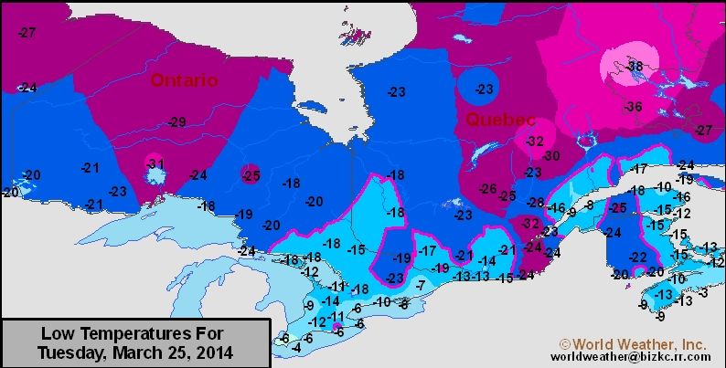
Temperatures will be slightly warmer for the remainder of the coming week, but will only warm
into a near average range for this time of year. Most regions will warm above freezing beginning
Friday, which will help melt the snow that is currently on the ground. Far southern Ontario may
lose all of the snow on the ground by next Tuesday, but areas further to the north will need
additional warming before all the snow melts. Flood potentials remain high due to the abundance
of moisture in the soil beneath the snow.
The cold airmass will slowly sweep across eastern Canada today and Wednesday, which
will continue to generate light shower activity in the major production regions. Temperatures
will fail to warm above freezing during the next two days, meaning precipitation will fall as
snow. Most regions will have an opportunity to receive snow, but any snow that reaches the
ground will be too light to significantly boost snow depths. Accumulations will range from a
dusting to 3 or 4 centimeters and locally greater amounts. Precipitation coverage will be 80
percent.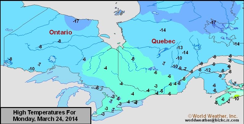
Precipitation potentials will then increase significantly throughout southeastern Canada
Thursday and Friday. A strong low pressure center will advance across the region to end the
week. Precipitation will initially evolve in southeastern Ontario Thursday morning before
spreading into southern Quebec by Thursday afternoon. Snow will initially fall in Ontario
Thursday morning before gradually turning into rain by Thursday afternoon. Most portions of
Ontario will be warm enough for a mixture of rain and snow to fall Thursday evening and Friday
morning before again turning into rain during the day Friday. Snow will fall in Quebec Thursday
afternoon through Friday morning before gradually turning into rain during the day Friday. The
most significant precipitation in Ontario will fall as rain Thursday evening and Friday morning,
though most of the significant precipitation will fall as snow in Quebec. Accumulations in
southern Ontario will range from 3 to 9 centimeters with locally greater amounts near the
Quebec border. Accumulations in southern Quebec will range from 5 to 15 centimeters and
locally greater amounts. Precipitation coverage will be 100 percent.
        A secondary low pressure center will produce precipitation in southeastern Ontario and
southern fringes of Quebec Saturday and Sunday morning. Precipitation will primarily fall as
snow with accumulations that will range from a dusting to 4 or 5 centimeters and locally greater
amounts near Lake Erie.
        A third disturbance will drift near the region Monday evening and next Tuesday.
Temperatures will be warm enough for precipitation to initially occur as rain before turning into
snow by next Tuesday morning. Most locations will receive at least a dusting of snow from this
system, but confidence in the amount of precipitation that will occur is low. There will continue
to be several opportunities for precipitation April 2 – 8.

Warmer Weather Expected Later This Week
       Cold weather will continue to dominate southeastern Canada during the next two days.
Temperatures will begin to warm Thursday and will remain in a near normal temperature bias
most often through next Tuesday. A second cold airmass will then potentially sweep across the
region sometime during the middle of next week, which would again lower temperatures into a
below average bias. Temperatures will continue to moderate between warm and cold for the
remainder of the April 2 – 8 time period as well.
       High temperatures today and Wednesday will range from -6 to 0 most often. Highs
Thursday will range from -3 to 3 and highs Friday through next Tuesday will range from 3 to 9
most often. Lows Wednesday and Thursday will range from -14 to -8 and lows Friday through
next Tuesday will range from -4 to 2.

Winds
        High wind speeds will occur Thursday and Friday when the first disturbance will advance
across the region. Sustained wind speeds will range from 25 to 40 kph with gusts of 55 kph or
higher. High wind speeds will also be possible next Tuesday when a low pressure center drifts
near the region. Blowing and drifting of snow will be possible, which will reduce visibilities and
potentially slow travel. Wind speeds most other days during the coming week will not be high
enough to cause many problems for travel.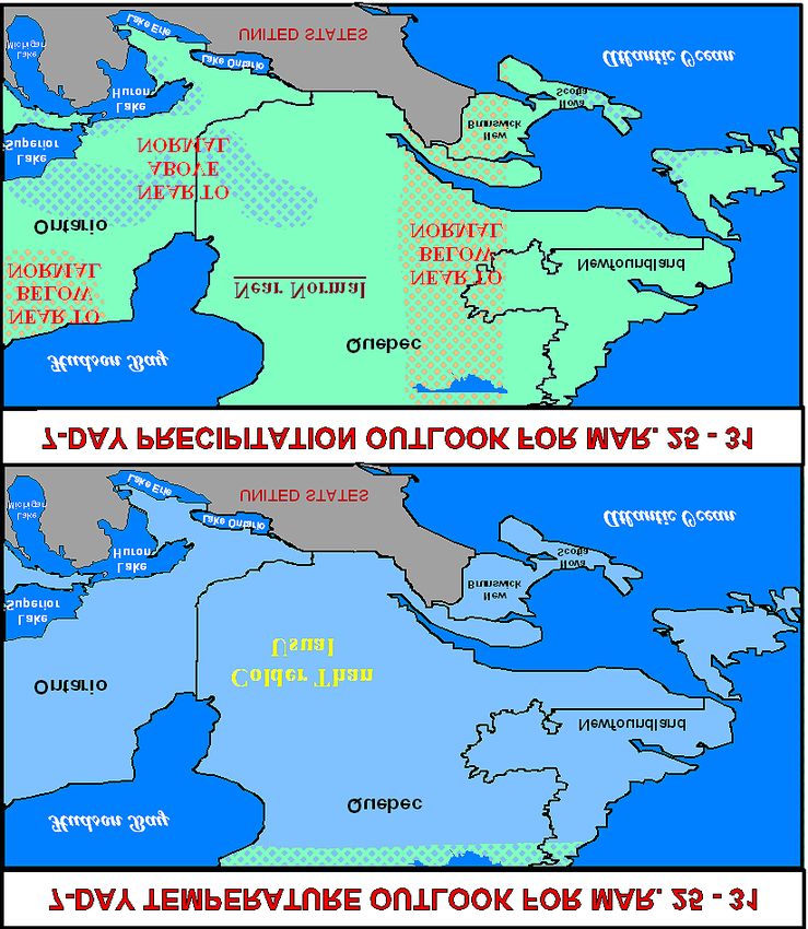
7-Day Outlook

World Weather, Inc. forecasts and comments pertaining to present, past and future weather conditions included in
this report constitute the corporation's judgment as of the date of this report and are subject to change without notice.
Comments regarding damage or the impact of weather on agricultural and energy as well as comments made
regarding the impact of weather on the commodity and financial markets are the explicit opinions of World
Weather, Inc. World Weather, Inc. cannot be held responsible for decisions made by users of the Corporation's
information in any business, trade or investment decision.

©2014 World Weather, Inc. Any unauthorized redistribution, duplication or disclosure is prohibited by law and will
result in prosecution.
You can also read