WEST COAST THE CLIMATE AND WEATHER OF - 2nd edition G. R. Macara - NIWA
←
→
Page content transcription
If your browser does not render page correctly, please read the page content below
THE CLIMATE AND WEATHER OF

WEST COAST
2nd edition         G. R. Macara
© 2016. All rights reserved. The copyright for this report, and for the data, maps, figures and other information
(hereafter collectively referred to as “data”) contained in it, is held by NIWA. This copyright extends to all forms
of copying and any storage of material in any kind of information retrieval system.

While NIWA uses all reasonable endeavours to ensure the accuracy of the data, NIWA does not guarantee or
make any representation or warranty (express or implied) regarding the accuracy or completeness of the data,
the use to which the data may be put or the results to be obtained from the use of the data. Accordingly, NIWA
expressly disclaims all legal liability whatsoever arising from, or connected to, the use of, reference to, reliance
on or possession of the data or the existence of errors therein. NIWA recommends that users exercise their own
skill and care with respect to their use of the data and that they obtain independent professional advice relevant
to their particular circumstances.

NIWA SCIENCE AND TECHNOLOGY SERIES
NUMBER 72

ISSN 1173-0382

Note to Second Edition
This publication replaces the first edition of New Zealand Meteorological Service Miscellaneous Publication 115
(10), written in 1982 by J. W. D. Hessell. It was considered necessary to update the first edition, incorporating
more recent data and updated methods of climatological variable calculation.
THE CLIMATE AND WEATHER OF
WEST COAST
2nd edition           G. R. Macara
SUMMARY
West Coast is New Zealand’s wettest region,
and this may be attributed to its exposure to the
predominant westerly airflow over the country,
combined with the orographic effect of the
Southern Alps. Annual rainfall totals at relatively
high elevations regularly exceed 10,000 mm, with
low elevation coastal locations typically recording
between 2,000 and 3,000 mm of rainfall annually.
Temperatures in lowland areas remain mild
throughout the year, with temperatures less than
0°C and greater than 25°C occurring infrequently
compared to most other regions of New Zealand.
West Coast is not especially windy, and local wind
regimes are strongly influenced by the southwest
to northeast orientation of the Southern Alps.

                                                      Photo: ©mychillybin.co.nz/Jingyi Tan
CONTENTS
SUMMARY                                       4

INTRODUCTION                                  7

TYPICAL WEATHER SITUATIONS IN WEST COAST       9
   Disturbed westerly flows                    9
   Northerly flows                             9
   Southeasterly flows                        10
   Fine weather spells                        10

CLIMATIC ELEMENTS                             13
   Wind                                       13
   Rainfall                                   16
     Rainfall distribution                    16
     Rainfall frequency and intensity         20
     Recent extreme events in West Coast      22
     Periods of low rainfall                  22
   Temperature                                23
     Sea surface temperature                  23
     Air temperature                          24
     Earth temperatures                       27
     Frosts                                   28
   Sunshine and solar radiation               29
     Sunshine                                 29
     Solar radiation                          30
     UV (ultra-violet) radiation              30
   Other elements                             31
     Thunderstorms and hail                   31
     Fog                                      31
     Snow                                     31

DERIVED CLIMATOLOGICAL PARAMETERS             33
  Vapour pressure and relative humidity       33
  Evapotranspiration and soil water balance   34
  Degree-day totals                           36

ACKNOWLEDGEMENTS                              38

REFERENCES                                    38

                                                   5
6
Photo: ©mychillybin.co.nz/Haupiri Net Images
INTRODUCTION
New Zealand spans latitudes 34 to 47
degrees south, and so lies within the
Southern Hemisphere temperate zone. In
this zone, westerly winds at all levels of
the atmosphere move weather systems,
which may also be either decaying or
developing, eastwards over New Zealand
giving great variability to its weather.
The Southern Alps act as a barrier to the
prevailing westerly airstream which is both
deflected by them and forced to ascend;
this causes rain which is often heavy and
prolonged in West Coast. These prevailing
westerlies sometimes abate, and air from
either tropical or polar regions may reach
New Zealand with heavy rainfalls or cold
showery conditions respectively. The effect
of the oceans on air of tropical origin is to
cool the lower layers, creating extensive
sheets of stratiform cloud capable of
producing large amounts of rain in
West Coast, especially when entrained
into cyclonic (low pressure) systems
and subjected to orographic processes.
Conversely, air originating from the far
south typically reaches New Zealand as
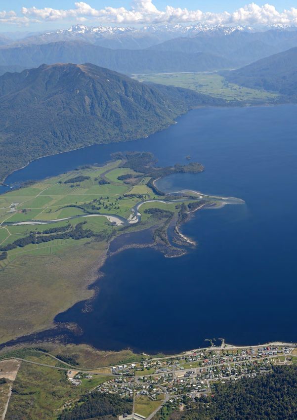
a southerly airstream, and the Southern Figure 1. Map of the West Coast region, showing the places mentioned in
Alps protect West Coast from the this publication.
instability showers formed when cold air
is heated from below by a relatively warm
sea surface. Under these circumstances,
West Coast experiences fine weather
and sunny skies with exceptionally good
visibility.
numerous glaciers. The Fox Glacier and Franz Josef Glacier are
The West Coast region (Figure 1) is
particularly renowned and contribute to the ongoing tourism of
bounded in the west by the coast, and
the region. These glaciers reach comparatively low altitudes for
in the east by the main divide of the
middle latitudes and their rates of flow are relatively fast due to
Southern Alps which reaches 3,724 m at
the steep topography of the western face of the Southern Alps
the summit of Mount Cook. The region
down which they descend. These glaciers respond relatively
drains westwards to the coast, and the
quickly to climatic forcings; their dynamic nature make these
river systems are subject to remarkable
glaciers useful indicators of climate variability and change.
fluctuations in flow in response to rainfall
events. The river catchments extend into Note that all numbers given in the following tables are calculated
high alpine regions, where a proportion from the 1981–2010 normal period (a normal is an average
of the considerable annual precipitation or estimated average over a standard 30-year period), unless
falls as snow, enabling the formation of otherwise stated.
7
8
Photo: ©mychillybin.co.nz/Mark Meredith
TYPICAL WEATHER
SITUATIONS IN WEST COAST
Surface winds on the West Coast tend to be light and
variable, and are influenced both by the synoptic-scale
circulation and by large frictional effects caused by
the mountain barrier to the east. Nevertheless the
weather is strongly typified by the wind flow in the free
atmosphere above the friction layer, and the following
sections refer to the direction of this wind rather than
to local surface wind directions.

Disturbed westerly flows
Disturbed westerly flows over New Zealand are
associated with depressions to the south of the country
which usually move rapidly eastward (Figure 2). The
flow may be intensified by development and southward
movement of the belt of subtropical anticyclones which
in turn are associated with changes in the principal
upper-air hemispheric jet stream. The seasonal
                                                            Figure 2. Mean sea level pressure analysis for 0000 hours NZDT
changes in the general circulation of the Southern
                                                            on 16 October 1977.
Hemisphere as described above result in a maximum
frequency of disturbed westerly situations in spring
(Reid, 1980). The “disturbances” in the westerlies may
have varied dynamics; most are usually depicted on
synoptic charts as cold fronts.

Winds just above the surface friction layer ahead of
each front tend to be north of west and are almost
perpendicular to the Alpine divide. The fronts are
preceded by rain in West Coast which is often heavy
due to orographic uplift. The change in wind direction
to the southwest behind the fronts usually brings
an initial dramatic clearance in the weather, though
showers soon re-develop with the gradual change of
winds back towards the west in the generally rather
unstable conditions.

Northerly flows
Extensive northerly airflows (Figure 3) between an
anticyclone (high pressure system) and a depression
(low pressure system) are usually accompanied
by prolonged rainfall which can reach torrential            Figure 3. Mean sea level pressure analysis for 0000 hrs NZST on
                                                            15 August 1977.
intensities in the Southern Alps. The skies over the
West Coast typically remain overcast throughout these
periods. The majority of West Coast’s rain occurs
in winds having a northerly component, and the
temperature during these rainfall events is relatively
mild. The occurrence of thunder during the rain often

                                                                                                                              9
heralds the arrival of the front, which brings a change
     to south-westerly winds and clearing skies.

     Southeasterly flows
     Southeast winds are often accompanied by clear skies
     in West Coast as the air has lost moisture during uplift
     on the eastern side of the Southern Alps. Southeast
     airstreams over the South Island are usually caused
     by depressions (lows) over the North Island and
     anticyclones (highs) to the south of the country (Figure
     4). The foehn effect occurs in West Coast under strong
     southeast gradients, just as they do in eastern parts
     of the South Island under strong northwest gradients.
     The highest temperatures recorded in West Coast
     occur during southeast airflows in summer, and
     southeast winds usually result in higher than average
                                                                Figure 4. Mean sea level pressure analysis for 0000 hours NZST
     temperatures at all times of the year.                     on 12 April 1981.

     Fine weather spells
     Fine weather spells are usually associated with an
     anticyclone moving slowly eastwards over the South
     Island, or the area just south of it. If a depression
     develops to the north or north-east of the North Island
     a ridge of high pressure may still extend over the
     South Island when the anticyclone is centred far to the
     east or south-east. Prolonged dry spells are relatively
     infrequent in West Coast, and usually occur when
     an anticyclone becomes stationary over or very near
     New Zealand. Figure 5 shows a situation in which the
     air pressure over New Zealand is very high, with two
     intense anticyclones separated by a trough of relatively
     low pressure. The anticyclone east of New Zealand
     is forming a “block” to the progression of the trough
     which has become stationary, and the weather over the      Figure 5. Mean sea level pressure analysis for 0000 hours NZST
                                                                on 20 July 1971.
     whole country including West Coast is fine and settled.
     In this case, no rain occurred at Hokitika between 5
     July and 25 July 1971, and the anticyclone east of New
     Zealand intensified to 1040 hPa at times.

10
11
Photo: ©mychillybin.co.nz/jeremy town
CLIMATIC ELEMENTS
Wind
Wind direction over New Zealand in the
zone directly above the Earth’s surface
may be interpreted from a mean sea
level pressure (MSLP) map, following
the general principle that air flows in a
clockwise direction around a depression
(a ‘low’), and in an anticlockwise direction
around an anticyclone (a ‘high’). As such,
MSLP maps can be used to indicate the
general wind direction at the Earth’s
surface. However, actual wind direction
at a particular locality is modified by
the influence of friction and topography.
Furthermore, wind speeds are also subject
to topographical influence. Northwest
winds are relatively uncommon in West
Coast, as they are typically deflected to the
northeast or southwest by the Southern
Alps. As such, northeasterlies and
southwesterlies are the predominant wind
directions in West Coast, especially for
stronger winds, but there are local variants
to this general rule.

The direction of a steady sea breeze flow
on most coastal areas is southwest, and
sea breezes are common near the coasts
in summer. Occasionally these penetrate
                                                 Figure 6. Mean annual wind frequencies (%) of surface wind directions from
considerable distances up some valleys,          hourly observations at selected West Coast stations. The plot shows the
adding to the frequency of moderate              directions from which the wind blows, e.g. the dominant wind direction at
                                                 Haast is from the south-east.
strength southwesterlies in these areas.
Katabatic winds, which are gravity winds
caused by comparatively cold dense air
flowing down the river valleys, are most         Mean wind speed data (average wind speeds are taken over the
noticeable on winter nights. Such winds          10 minute period preceding each hour) are available for a number
are usually of moderate strength but             of sites in West Coast, and these illustrate the several different
may become stronger under favourable             wind regimes of the region (Table 1). Mean wind speeds are
synoptic conditions. Their formation is also     highest at coastal locations such as Greymouth and Westport,
enhanced by snow-covered high ground             and lowest at the sheltered inland location of Reefton. There is
due to the radiative properties of a snow        notable variability in mean monthly wind speeds over the course
surface which becomes substantially              of a year in West Coast, with the highest wind speeds typically
colder at night than the free air at a similar   observed in spring. The exception is Greymouth, where highest
level. Figure 6 shows mean annual wind           wind speeds are observed in winter. This may be attributed in part
frequencies of surface wind based on             to the katabatic wind, which locally is reputed to be cold enough
hourly observations from selected West           to ‘shave the hair off one’s head’, and has consequently earned
Coast stations.                                  the nickname “barber”.

                                                                                                                              13
Table 1. Mean monthly and annual wind speed (km/hr) for selected West Coast locations, from all available data.
Location Jan Feb Mar Apr May Jun Jul Aug Sep Oct Nov Dec Ann
Westport 13.8 12.8 12.4 12.2 12.5 13.2 12.9 12.9 14.9 16.0 15.6 14.7 13.7
Greymouth 13.5 11.1 12.0 13.4 13.6 14.5 14.7 12.7 14.0 14.5 13.7 12.7 13.4
Hokitika 11.7 10.5 10.3 9.8 9.9 10.1 9.6 10.2 11.7 13.2 12.9 12.2 11.0
Haast 9.2 8.4 8.9 9.5 10.7 11.1 11.6 10.7 11.0 11.8 11.2 10.1 10.3
Franz Josef 8.5 7.8 7.4 7.4 7.2 7.3 7.2 7.3 8.3 8.5 8.4 8.4 7.8
Reefton 6.6 5.8 5.4 4.8 4.4 4.1 3.9 5.0 6.0 6.5 6.6 6.5 5.4
Table 2 gives the seasonal distribution and frequency
of occurrence of strong winds (defined as having a
daily mean wind speed of greater than 30 km/hr). For
example, of all strong winds recorded at Greymouth,
30% occur in winter. In addition, during a Greymouth
winter an average of nine days have a daily mean wind
speed of greater than 30 km/hr. As a further example,
Greymouth and Reefton have a similar distribution of
strong winds in autumn, with 26% and 24% of their
respective annual strong winds being recorded in
that season. However, Greymouth has an average of
eight strong wind days in autumn, compared to just
two in Reefton. This highlights that although a similar
seasonal distribution of strong winds may be observed
between different locations in West Coast, the actual
number of strong wind days per season at those
locations may be considerably different.
Table 2. Seasonal distribution and frequency (mean number of days) of strong winds (daily mean wind speed > 30 km/hr) recorded at
selected West Coast locations, from all available data.
Location Summer Autumn Winter Spring Annual
Distribution Frequency Distribution Frequency Distribution Frequency Distribution Frequency Frequency
Greymouth 18% 5 26% 8 30% 9 26% 8 31
Haast 16% 4 27% 7 29% 8 28% 7 26
Westport 19% 4 21% 4 27% 5 33% 6 19
Hokitika 24% 2 21% 2 20% 2 34% 4 10
Reefton 32% 3 24% 2 11% 1 32% 3 8
Franz Josef 22% 1 23% 1 34% 1 21% 1 3
Diurnal variation in wind speed is well-marked, with
Reefton Westport
highest wind speeds occurring mid-afternoon before 20
Mean wind speed (km/hr)
18
decreasing overnight. This is because heating of 16
the land surface is most intense during the day, and 14
12
stronger winds aloft are brought down to ground level 10
8
by turbulent mixing. Cooling at night generally restores 6
a lighter wind regime. Table 3 gives average wind 4
2
speeds at three-hourly intervals for selected locations, 0
0 3 6 9 12 15 18 21
whilst Figure 7 visually highlights the typical diurnal
Hour of day
variation of wind speed observed throughout West Figure 7. Mean wind speed at selected hours of the day for
Coast. Reefton and Westport.
14Table 3. Mean wind speed (km/hr) at three-hourly intervals of the day.
Location 0000 0300 0600 0900 1200 1500 1800 2100
Franz Josef 6.2 6.5 6.5 6.6 8.4 11.9 9.6 6.7
Greymouth 12.6 12.5 12.6 13.0 14.2 14.5 14.2 13.1
Haast 8.7 9.4 9.8 10.1 12.3 14.5 12.6 9.5
Hokitika 8.8 8.7 8.8 9.4 13.0 14.9 12.7 9.9
Reefton 4.5 4.2 4.0 6.0 6.2 7.7 7.0 5.5
Westport 11.1 11.3 11.4 11.5 15.1 17.3 15.3 12.1
Gusty winds are relatively infrequent throughout Table 4. Mean number of days per year with gusts exceeding 61
most lowland West Coast locations, occurring more km/hr and 94 km/hr for selected locations.
frequently in the mountain ranges and exposed coastal Days with Days with
locations. Greymouth experiences an average of 46 Location gusts >61 gusts >94
km/hr km/hr
days per year with wind gusts exceeding 61 km/hr,
Franz Josef 17 0.7
considerably more than Reefton where on average
Greymouth 46 0.9
less than one such day per year is recorded (Table
Hokitika 29 0.7
4). Maximum gusts recorded at different West Coast
Reefton 0.4 0
locations are listed in Table 5. The highest gust
Westport 41 2
recorded in the region was 140.8 km/hr, occurring at
Greymouth on 17 April 2014.
Table 5. Highest recorded wind gusts at selected West Coast
locations, from all available data.
Location Gust (km/hr) Direction Date
Franz Josef 109.3 WNW 10/07/2011
Greymouth 140.8 E 17/04/2014
Hokitika 133.4 W 14/05/1979
Reefton 66.7 NE 01/03/2009
Westport 135.3 SE 16/07/1976
Photo: ©mychillybin.co.nz/ Vibeke Friis
15Rainfall
Rainfall distribution
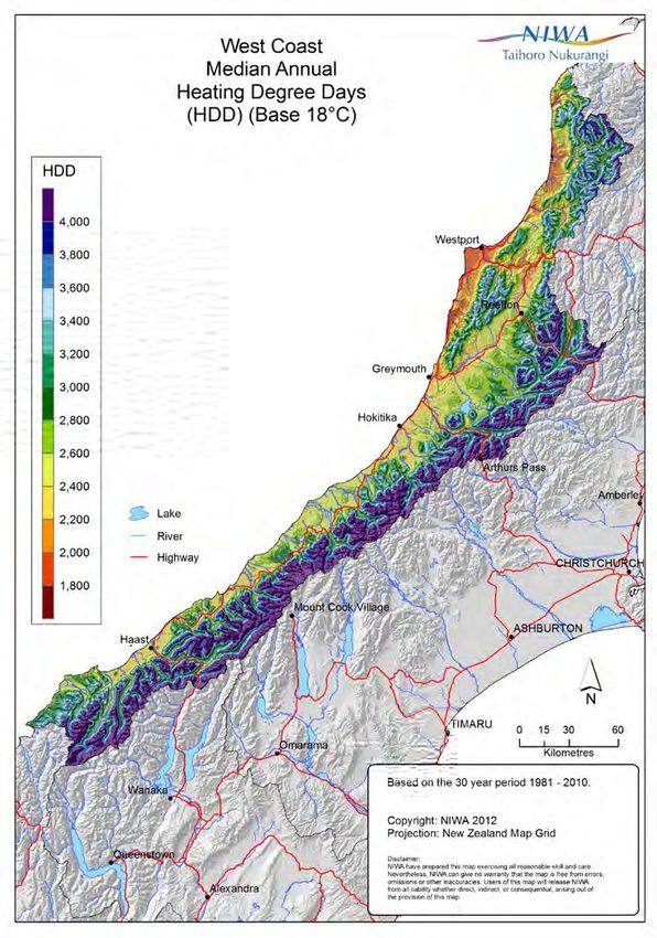
The spatial distribution of West Coast’s
median annual rainfall is shown in
Figure 8, which clearly illustrates both its
dependence on elevation and exposure
to the main rain bearing airflows from
the west. Rainfall is highest among the
main divide which has both high elevation
and western exposure. Such high rainfall
is primarily a result of the orographic
effect. Specifically, moisture-laden air
masses passing over the Tasman Sea
and are forced to rise over the Southern
Alps. As these air masses rise, they cool
rapidly, causing the stored water vapour
to condense, resulting in rainfall. Inland
low elevation locations around Reefton
are located in the rain-shadow of the
Paparoa Range, and receive considerably
less rainfall than many other West Coast
locations. In coastal locations, the general
trend is for annual rainfall to increase
towards the southern-most parts of the
region. West Coast is New Zealand’s
wettest region, and wet periods, however
defined, are relatively common compared
with the remainder of the country. Figure 8. West Coast median annual total rainfall, 1981–2010.
Table 6 lists monthly rainfall normals and
the percentage of annual total for selected
locations. The seasonal distribution of
rainfall is fairly even throughout West
Coast. Most locations observe a rainfall
minimum in February, however this is
generally offset by relatively high rainfalls
in December, which balances out the
summer rainfall totals received. The
distribution of monthly rainfall is shown
in Figure 9. The 10th percentile, 90th
percentile, and mean rainfall values
for each month are shown along with
maximum and minimum recorded values
for several stations.
16Table 6. Monthly and annual rainfall normal (a; mm), and monthly distribution of annual rainfall (b; %) at selected West Coast
locations, for the period 1981–2010.
Location Jan Feb Mar Apr May Jun Jul Aug Sep Oct Nov Dec Ann
a 1117 696 872 866 917 897 680 846 967 1240 1007 1288 11400
Cropp River
b 10 6 8 8 8 8 6 7 8 11 9 11
a 567 387 473 407 446 451 352 422 505 595 487 659 5751
Franz Josef
b 10 7 8 7 8 8 6 7 9 10 8 11
a 209 161 177 195 197 238 198 192 209 225 197 252 2452
Greymouth
b 9 7 7 8 8 10 8 8 9 9 8 10
a 211 204 184 203 246 267 183 243 221 273 197 301 2732
Hokitika
b 8 7 7 7 9 10 7 9 8 10 7 11
a 190 132 180 178 206 193 260 211 201 239 191 253 2433
Inangahua
b 8 5 7 7 8 8 11 9 8 10 8 10
a 146 91 132 168 192 159 158 129 186 166 152 190 1868
Karamea
b 8 5 7 9 10 9 8 7 10 9 8 10
a 246 173 187 240 201 253 256 319 232 332 297 259 2995
Kopara
b 8 6 6 8 7 8 9 11 8 11 10 9
a 392 328 365 309 344 387 272 313 356 428 391 415 4301
Lake Moeraki
b 9 8 8 7 8 9 6 7 8 10 9 10
a 526 366 527 376 440 486 381 381 502 550 482 573 5588
Lake Paringa
b 9 7 9 7 8 9 7 7 9 10 9 10
a 146 106 117 143 167 200 169 173 177 196 162 189 1943
Reefton
b 8 5 6 7 9 10 9 9 9 10 8 10
a 239 175 210 208 227 226 246 191 250 260 282 301 2813
Seddonville
b 9 6 7 7 8 8 9 7 9 9 10 11
a 1029 643 835 789 808 804 576 739 971 1177 946 1241 10558
Tuke River
b 10 6 8 7 8 7 6 7 9 11 9 11
a 158 128 136 142 171 230 139 192 184 209 168 190 2046
Westport
b 8 6 7 7 8 11 7 9 9 10 8 9
Hokitika Reefton Westport
100 200 300 400 500 600 700
100 200 300 400 500 600 700
100 200 300 400 500 600 700
Rainfall (mm)
Rainfall (mm)
Rainfall (mm)
0
0
0
J FMAMJ J A S OND J FMAMJ J A S OND J FMAMJ J A S OND
Cropp River Franz Josef
600 1200 1800 2400 3000
900 1200 1500
Highest Monthly Total
Rainfall (mm)
Rainfall (mm)
90 Percentile Value
600
Mean
300
10 Percentile Value
0
0
Lowest Monthly Total
J FMAMJ J A S OND J FMAMJ J A S OND
Figure 9. Monthly variation of rainfall for selected West Coast locations from all available data.
17Rainfall variability is further indicated by rainfall
deciles, as given in Tables 7, 8 and 9. The 10th
percentile values show the accumulated rainfalls
that will normally be exceeded in nine out of ten
years, while the 90th percentile values indicate the
accumulated falls that will normally be exceeded in
only one year in ten. The tables include periods from
one month to twelve months (annual), with each time
period that is longer than one month beginning with
the month stated. For example, using the table for
Greymouth (Table 8), it can be seen that in the three
month period beginning in January, 404 mm or more
of rainfall can be expected in nine years in ten, while a
total of 766 mm or more should occur in only one year
in ten.
Table 7. Rainfall means and deciles at monthly, 3-monthly, 6-monthly, 9-monthly and annual intervals for Cropp River from all
available data.
Jan Feb Mar Apr May Jun Jul Aug Sep Oct Nov Dec
Cropp River
1 month
90th 1912 1127 1674 1773 1675 1492 1248 1377 1606 2401 1934 2339
Mean 1118 696 873 867 918 898 680 846 967 1241 1008 1288
10th 445 230 375 285 390 365 316 341 308 536 266 598
3 months
90th 3779 3510 3872 3608 3504 3506 3399 4134 4423 4727 4966 4830
Mean 2650 2424 2623 2633 2474 2432 2437 3015 3217 3525 3415 3130
10th 1882 1473 1550 1807 1476 1711 1330 1632 1930 2400 2068 2060
6 months
90th 6750 5690 6501 6531 6972 7322 7117 7612 7770 7635 7571 7922
Mean 5263 4843 4998 5122 5501 5632 6025 6498 6287 6132 5816 5760
10th 3813 3609 3601 3614 3757 3703 4567 5210 4972 4698 4164 4101
9 months
90th 9773 9434 10370 10275 10414 10451 10546 10105 10406 10488 10228 9810
Mean 7870 7898 8214 8687 8827 8680 8673 8871 8873 8667 8157 8135
10th 6181 6389 6168 6601 6902 7007 7149 7149 6979 6325 6099 5853
Annual
90th 13473
Mean 11357
10th 9354
18Table 8. Rainfall means and deciles at monthly, 3-monthly, 6-monthly, 9-monthly and annual intervals for Greymouth from all
available data.
Jan Feb Mar Apr May Jun Jul Aug Sep Oct Nov Dec
Greymouth
1 month
90th 300 264 312 355 338 334 314 307 331 367 330 370
Mean 202 165 190 211 218 213 195 195 199 225 211 227
10th 96 70 99 77 115 97 83 98 92 134 94 106
3 months
90th 766 775 833 780 780 775 832 879 845 873 892 842
Mean 557 566 619 641 624 603 589 619 635 662 641 592
10th 404 371 474 490 493 459 387 414 470 483 442 387
6 months
90th 1498 1498 1480 1509 1522 1488 1541 1484 1512 1480 1520 1475
Mean 1198 1190 1220 1228 1242 1237 1251 1258 1228 1221 1206 1211
10th 983 929 961 1014 998 983 960 994 969 925 874 968
9 months
90th 2121 2173 2256 2261 2198 2172 2172 2188 2193 2267 2191 2134
Mean 1785 1807 1855 1893 1887 1832 1808 1823 1847 1862 1831 1812
10th 1484 1477 1498 1521 1574 1495 1454 1460 1489 1525 1465 1469
Annual
90th 2853
Mean 2450
10th 2032
Table 9. Rainfall means and deciles at monthly, 3-monthly, 6-monthly, 9-monthly and annual intervals for Reefton from all
available data.
Jan Feb Mar Apr May Jun Jul Aug Sep Oct Nov Dec
Reefton
1 month
90th 259 206 194 249 310 303 283 277 287 329 291 277
Mean 148 103 117 155 174 187 167 173 185 193 169 168
10th 66 29 50 59 68 103 54 84 76 98 61 70
3 months
90th 515 547 651 665 712 679 767 760 710 670 677 559
Mean 367 374 448 517 529 528 525 551 541 525 482 419
10th 236 225 284 372 363 400 335 351 404 354 327 261
6 months
90th 1089 1166 1209 1311 1366 1349 1331 1264 1186 1135 1152 1120
Mean 888 907 978 1046 1084 1069 1052 1034 964 891 856 868
10th 681 690 717 831 822 846 803 823 759 690 613 611
9 months
90th 1792 1839 1866 1891 1889 1784 1772 1726 1645 1737 1730 1699
Mean 1416 1456 1520 1577 1571 1499 1425 1408 1412 1413 1392 1398
10th 1163 1209 1243 1339 1319 1229 1134 1124 1113 1113 1126 1160
Annual
90th 2329
Mean 1947
10th 1644
19Rainfall frequency and intensity
Table 10 lists the average number of days per month Heaviest short period rainfalls in West Coast are
with at least 0.1 mm (a ‘rain day’) and at least 1 mm (a recorded at relatively high elevations, which often
‘wet day’) of rain for selected locations. The average occur when persistent west/northwesterly airflows are
number of days each year on which 0.1 mm or more of established as a trough approaches the South Island.
rain is recorded varies from 140 days at Inangahua to These moisture-laden airflows bring considerable
206 days at Franz Josef and Hokitika. Inangahua and rainfall totals throughout the region, even at relatively
Lake Paringa exhibit the lowest number of wet days low elevations along the coast. In Table 11, maximum
in the region, with 136 and 147 wet days recorded on short period rainfalls for periods of 10 minutes to 72
average respectively, compared with 185 wet days at hours with calculated return periods are given for
Franz Josef. The number of rain and wet days recorded Greymouth and Reefton. Also listed in this table are
at a given station tends to be higher nearer the coast, the maximum rainfalls expected in 2, 5, 10, 20, and 50
and lower at locations farther inland. A seasonal years. Depth-duration frequency tables for West Coast
variation of rain days and wet days is present in most locations are available from NIWA’s High Intensity
West Coast locations, with a maximum occurring in Rainfall Design System (HIRDS). HIRDS uses the index-
spring. This may be attributed to the seasonal changes frequency method to calculate rainfall return periods.
in the general circulation of the Southern Hemisphere For more information on methods and to use the tool,
described previously, which result in a maximum see http://hirds.niwa.co.nz/.
frequency of disturbed westerly situations in spring.
Table 10. Average monthly rain days (a; days where at least 0.1 mm rainfall is measured) and wet days (b; days where at least 1 mm
rainfall is measured) at selected West Coast locations.
Location Jan Feb Mar Apr May Jun Jul Aug Sep Oct Nov Dec Ann
a 16 15 15 16 16 16 14 18 20 21 18 20 206
Franz Josef
b 14 14 13 14 15 15 13 16 18 19 16 18 185
a 15 13 15 16 17 16 16 18 19 20 18 18 201
Greymouth
b 13 11 13 14 15 14 14 15 16 17 15 15 173
a 16 13 15 16 18 17 16 18 20 21 19 18 206
Hokitika
b 12 10 13 13 15 14 13 15 17 17 15 16 170
a 10 9 10 11 13 12 12 12 13 14 13 12 140
Inangahua
b 9 8 10 11 12 11 11 11 12 14 13 12 136
a 12 11 12 13 14 15 14 14 15 17 16 13 167
Karamea
b 11 10 11 12 13 14 12 13 14 15 15 12 151
a 15 12 13 11 16 15 13 18 17 22 18 18 187
Kopara
b 13 10 11 10 15 13 12 17 15 19 16 16 167
a 12 11 12 12 15 15 13 15 15 17 13 15 166
Lake Moeraki
b 12 10 12 11 15 15 13 14 15 16 13 15 160
a 12 10 12 11 13 12 11 11 13 14 14 13 149
Lake Paringa
b 12 10 12 11 13 12 11 11 13 14 14 13 147
a 13 11 13 14 16 16 16 17 19 19 17 16 187
Reefton
b 11 9 10 11 14 13 13 13 16 16 14 14 153
a 14 11 14 12 15 14 15 16 18 19 16 16 179
Seddonville
b 12 10 12 10 14 13 14 15 17 17 15 15 164
a 14 12 15 16 18 18 17 18 19 20 18 17 200
Westport
b 12 10 12 13 15 15 14 15 16 17 15 15 171
20Table 11. Maximum recorded short period rainfalls and calculated return periods from HIRDS.
Location 10min 20min 30min 1hr 2hrs 6hrs 12hrs 24hrs 48hrs 72hrs
Greymouth a 24.0 47.0 55.3 70.0 84.4 121.4 169.5 196.6 251.5 303.7
Apr Apr Apr Apr Apr Jan Jan Jan Apr Apr
b 1968 1968 1968 1968 1968 2000 2000 2000 1978 1957
c 100+ 100+ 100+ 100+ 100+ 77 100+ 52 59 81
d 9.3 13.8 17.4 25.8 35.2 57.4 78.1 106.3 133.3 152.3
e 11.9 17.6 22.2 32.9 44.3 71.1 95.8 129.1 162 185
f 13.9 20.6 26 38.5 51.6 81.9 109.7 146.8 184.2 210.4
g 16.2 24 30.3 44.9 59.7 93.9 124.9 166.1 208.4 238
h 19.8 29.3 36.9 54.7 72.2 112 147.7 194.9 244.6 279.3
Reefton a 16.0 23.3 24.1 27.3 40.9 72.2 117.0 176.3 242.6 271.0
Dec Dec Dec Jan Dec Apr Apr Jul 1983 Aug Aug
b 2009 2009 2009 2004 1979 1975 1975 1970 1970
c 100+ 100+ 67 25 29 27 50 66 100+ 83
d 6.6 9.2 11.1 15.3 22.8 42.7 63.4 94.3 120.7 139.5
e 8.3 11.5 14 19.3 28.4 52.4 77.2 113.6 145.4 168.1
f 9.7 13.4 16.3 22.5 32.9 60.1 87.9 128.5 164.5 190.2
g 11.2 15.6 18.8 26.1 37.9 68.5 99.5 144.6 185.2 214.1
h 13.6 18.8 22.8 31.5 45.4 81.1 117 168.6 215.9 249.5
a: highest fall recorded (mm)
b: month and year of occurrence
c: calculated return period of a (years)
d: max fall calculated with ARI 2 years (mm)
e: max fall calculated with ARI 5 years (mm)
f: max fall calculated with ARI 10 years (mm)
g: max fall calculated with ARI 20 years (mm)
h: max fall calculated with ARI 50 years (mm)
Photo: ©mychillybin.co.nz/Haupiri Net Images
21Recent extreme events in West Coast 13–14 September 1988: Heavy rain associated with a
West Coast has experienced numerous extreme northwest airflow combined with snow-melt to cause
weather events, with significant damage and disruption extensive flooding in West Coast, particularly in the
caused by heavy rain and flooding. The events listed Greymouth area. A Civil Defence Emergency was
below are some of the most severe rainfall and declared for the Inangahua County, Runanga Borough,
flooding events to have affected the West Coast region Greymouth Borough and Grey County due to flooding,
between 1988 and 2015. with 356 people evacuated from 183 houses. Stopbanks
along the lengths of the Grey and Ahaura rivers
23–25 November 2008: As an anticyclone (high
were severely damaged, and many farm fences were
pressure system) moved slowly to the east of New
destroyed. Significant numbers of stock were killed by
Zealand, a large depression (low pressure system)
the floodwaters, and substantial damage was caused
gradually moved across the Taman Sea. A strong,
by silting of farmland near the lower reaches of the
humid northerly flow contained between the two
Grey River, and in the Buller Gorge, Rotomaunu and Te
systems covered New Zealand on 23 November,
Kinga areas. At Dobson, the Grey River peaked at 5,768
carrying air down from the subtropics. On the night of
cumecs and was 5.8 metres above its normal level. In
24 November, the low crossed the South Island and
Greymouth, floodwaters were over 2 metres deep in
the flow tended westerly. Several fronts passed over
some lower parts of the town, and over a metre deep
the South Island, bringing enhanced bouts of heavy
on the aerodrome. Thick silt was deposited throughout
rainfall to West Coast. Widespread surface flooding
the city, much of it contaminated with sewage and oil.
occurred in the region with numerous road closures,
Greymouth recorded 107.4 mm of rain in the 24 hours
including the closure of State Highway 6 between
to 9 a.m. on 13 September 1988. Total flood damage
Whataroa and Haast where flooding was particularly
costs totalled approximately $16 million (1994 New
severe. Approximately 70% of the Fox Glacier access
Zealand dollars).
road was washed away when the Fox River burst its
banks on 25 November, leaving four cars stranded in Periods of low rainfall
the carpark. A rainfall gauge located at Cropp River
Periods of fifteen days or longer with less than 1 mm of
recorded 991 mm of rain in three days from 23 to 25
rain on any day are referred to as ‘dry spells’. Dry spells
November, and Greymouth recorded 122.5 mm of rain
are quite uncommon in most areas of West Coast, but
over the same period of time.
can occur throughout the region when a persistent
1–3 April 1991: A Civil Defence emergency was (blocking) anticyclone becomes established over the
declared in Franz Josef after prolonged heavy rain South Island. Additionally, the Southern Alps provide a
caused considerable flooding. The rainfall resulted great deal of sheltering for the region during easterly
from a warm, moist northwest airflow over the region airstreams, such that dry spell conditions can occur
due to a low pressure system centred southwest of in West Coast when considerable rain may be falling
the South Island and a high pressure system centred east of the main divide. Table 12 outlines the dry spell
east of the South Island. A total of 75 people were frequency and duration for Greymouth and Reefton.
evacuated from riverside homes, motels and the On average, a dry spell occurs once every 11 months
motor camp. The Waiho River rose dramatically, in Reefton, and once every 19 months in Greymouth.
and carried gravel and ice amongst other debris. At The longest dry spell was 40 days, recorded in Reefton
around 11 p.m. on 2 April, a wall of slush swept down from 6 February to 17 March 2013. Table 13 shows the
the valley, and dumped up to one tonne of ice on the seasonal distribution of dry spells at Greymouth and
Waiho River bridge surface. Franz Josef recorded 246 Reefton. Dry spell occurrence is notably infrequent
mm of rain in the 48 hours to 9 a.m. on 3 April 1991. during spring at both locations, reflecting the high
frequency of westerly airflows in that season.
Table 12. Dry spell (at least 15 consecutive days with less than 1 mm rainfall per day) frequency and duration for selected West Coast
locations, from all available data.
Location Frequency Mean duration (days) Max duration (days) Max duration date
Greymouth One every 19 months 17 39 6/2/2013 to 16/3/2013
Reefton One every 11 months 18 40 6/2/2013 to 17/3/2013
22Table 13. Seasonal distribution (%) of dry spells at selected West
Coast locations, from all available data.
Location Summer Autumn Winter Spring
Greymouth 25% 30% 35% 10%
Reefton 22% 36% 31% 11%
Temperature
Sea surface temperature
Monthly mean sea surface temperatures off the
coast of West Coast are compared with mean air
temperature for Greymouth and Reefton in Figure Greymouth air temp Reefton air temp Sea surface temp
18
10. There is a lag in the increase of sea surface 16
temperatures when compared to air temperatures 14
Temperature (°C)
from July to September. This is the result of the 12
10
greater heat capacity of the sea compared to land, 8
which results in the sea surface temperatures taking 6
4
longer to increase and decrease in response to
2
changing seasons compared to land-based areas. 0
Jan Feb Mar Apr May Jun Jul Aug Sep Oct Nov Dec
Greymouth records considerably higher mean air
Month
temperatures in winter compared with the inland Figure 10. Mean monthly air temperature (Greymouth and
location of Reefton, whereas Reefton observes higher Reefton) and estimated sea surface temperatures (off the coast
of West Coast).
mean temperatures than Greymouth in summer.
This is attributed to the moderating influence of the
sea on winter minimum temperatures and summer
maximum temperatures near the coast. Figure 11
shows the mean sea surface temperatures for the New
Zealand region for February and August, which are
the warmest and coolest months with respect to sea
surface temperatures.
A) MEAN FEBRUARY SST (°C) B) MEAN AUGUST SST (°C)
Figure 11. Monthly mean sea surface temperatures (°C) for: a) February; b) August. Source: NIWA SST Archive, Uddstrom and
Oien (1999).
23Air temperature
West Coast typically observes afternoon temperatures temperature in the West Coast region, and clearly
reaching between 18°C and 22°C in summer, and demonstrates that lower temperatures are recorded
overnight temperatures falling to between 1°C and at higher elevation locations. Low elevation locations
6°C in winter (Figure 12). Similar daily maximum have a median annual temperature of between 11°C
temperatures are recorded throughout West Coast in and 13°C. Median annual temperatures of below 2°C
summer, with the notable exception of high elevation occur along the main divide especially around Mt Cook,
areas where temperatures become increasingly which contributes to the perennial snow and glaciers
lower as elevation increases, and inland low elevation at high elevations in those areas. Figure 14 gives the
locations where temperatures are higher. In winter, monthly temperature regime (highest recorded, mean
daily minimum temperatures become lower as monthly maximum, mean daily maximum, mean, mean
distance from the coast and elevation increases. daily minimum, mean monthly minimum, and lowest
Figure 13 shows the median annual average recorded) for selected West Coast locations.
Figure 12. Left: West Coast median summer (December, January and February) average daily maximum temperature; Right: West
Coast median winter (June, July and August) average daily minimum temperature.
24Figure 13. West Coast median annual average temperature,
1981–2010.
Greymouth Haast Hokitika
−10 -5 0 5 10 15 20 25 30 35
−10 -5 0 5 10 15 20 25 30 35
−10 -5 0 5 10 15 20 25 30 35
Temperature (oC)
Temperature (oC)
Temperature (oC)
J F MAMJ J A S O ND J F MAMJ J A S O ND J F MAMJ J A S O ND
Reefton Westport
−10 -5 0 5 10 15 20 25 30 35
−10 -5 0 5 10 15 20 25 30 35
Highest Recorded
Mean Monthly Maximum
Temperature (oC)
Mean Daily Maximum
Mean
Mean Daily Minimum
Mean Monthly Minimum
J F MAMJ J A S O ND J F MAMJ J A S O ND Lowest Recorded
Figure 14. Monthly variation in air temperatures for selected West Coast locations from all available data.
Table 14 shows that the average daily temperature is least prominent in June and July. Average daily
range, i.e. the difference between the daily maximum temperature ranges are similar throughout the year at
and minimum temperature, is much smaller at coastal each coastal location, but are higher in Reefton during
locations than in inland areas (e.g. Reefton). This is summer compared with winter.
the case for most of the year, however the difference
25Table 14. Average daily temperature range (Tmax – Tmin, °C) for selected West Coast locations.
Location Jan Feb Mar Apr May Jun Jul Aug Sep Oct Nov Dec Ann
Greymouth 7.2 7.2 7.4 7.4 7.3 7.2 7.6 7.6 7.3 6.8 6.8 6.9 7.2
Haast 7.7 7.9 7.9 7.9 7.5 7.5 7.9 8.0 7.9 7.6 7.4 7.5 7.7
Hokitika 7.7 7.9 8.1 8.1 8.3 8.6 9.0 8.6 8.0 7.6 7.7 7.5 8.1
Reefton 11.9 12.2 11.4 10.6 9.3 8.5 9.3 10.4 10.3 10.4 10.9 11.2 10.6
Westport 7.5 7.6 7.5 7.4 7.4 7.5 7.8 7.6 7.2 6.9 7.0 7.0 7.3
Table 15 and Figure 15 further highlight the diurnal Reefton. Note that hourly mean air temperature at a
temperature range, showing the median hourly mean given time is calculated as the mean of the maximum
air temperature for January and July at Greymouth and minimum air temperature recorded over the
and Reefton. Air temperatures at Reefton remain previous hour. As such, daily temperature ranges
lower than Greymouth at all hours of the day in July. for January and July for Greymouth and Reefton
In January, the moderating influence of the sea on air calculated from Table 15 are lower than those in Table
temperatures at Greymouth are clearly demonstrated, 14, which are based on the extreme daily maximum
as daily minimum temperatures are higher and daily and minimum temperatures.
maximum temperatures are considerably lower than
Table 15. Median hourly mean air temperatures for January and July at Greymouth and Reefton.
00 01 02 03 04 05 06 07 08 09 10 11
January 14.7 14.5 14.3 14.1 13.9 13.6 13.4 13.4 13.8 14.8 15.8 16.4
July 7.2 7.1 7.0 7.1 6.7 6.6 6.4 6.3 6.2 6.4 7.4 8.4
Greymouth 12 13 14 15 16 17 18 19 20 21 22 23
January 16.9 17.4 17.7 18.0 18.1 18.0 17.8 17.4 17.0 16.4 15.8 15.3
July 9.5 10.3 11.0 11.2 11.2 10.6 9.1 8.3 7.8 7.7 7.5 7.4
00 01 02 03 04 05 06 07 08 09 10 11
January 14.9 14.0 13.5 13.3 13.0 12.6 12.3 12.0 12.5 13.9 15.5 17.0
July 3.7 3.7 3.5 3.1 2.9 2.7 2.7 2.5 2.4 2.5 3.1 4.5
Reefton
12 13 14 15 16 17 18 19 20 21 22 23
January 18.6 19.9 20.9 21.4 22.1 21.8 21.7 20.9 19.7 18.2 16.9 15.7
July 6.2 7.4 9.0 9.6 9.6 8.9 7.0 5.9 5.0 4.8 4.5 4.2
Greymouth (January) Reefton (January)
Greymouth (July) Reefton (July)
25
20
Temperature (°C)
15
10
5
0
0 1 2 3 4 5 6 7 8 9 10 11 12 13 14 15 16 17 18 19 20 21 22 23
Time (hours)
Figure 15. Median hourly mean air temperatures at Greymouth and Reefton in
January and July.
26Maximum air temperatures in excess of 25°C are
a rare occurrence for coastal areas of West Coast.
However, they do occur more frequently for inland
locations, particularly in Reefton, where an annual
average of 24 such days occur (Table 16). Inland
parts of West Coast record considerably more days
with a minimum temperature below 0°C compared
to locations closer to the coast. The highest air
temperature recorded in West Coast to date is 33.7°C
at Reefton on 4 January 1975. This temperature
occurred on the first day of a very hot spell in Reefton
from 4 January to 13 January 1975. During these 10
days, the average daily maximum temperature was
30.0°C, with the temperature reaching at least 30.3°C
on five out of the ten days. Reefton also recorded the
lowest air temperature in West Coast; -8.5°C on
8 July 1972.
Table 16. Highest and lowest recorded air temperatures, average number of days per year where maximum air
temperature exceeds 25°C, and average number of days per year where the minimum air temperature falls
below 0°C, for selected West Coast locations from all available data.
Highest Annual days Lowest Annual days
Location
recorded (°C) max temp > 25°C recorded (°C) min temp < 0°C
Greymouth 29.7 1 -2.5 2
Haast 29.0 0.8 -5.1 9
Hokitika 30.6 0.9 -6.6 14
Reefton 33.7 24 -8.5 46
Westport 28.5 1 -3.5 1
Earth temperatures 10 cm 100 cm Air temp
Earth (soil) temperatures are measured once daily 20
at 9 a.m. at several West Coast locations. Earth
15
temperatures are measured at varying depths and are
Temperature (°C)
important for determining the growth and development 10
of plants. Different plants have different rooting
depths and as such, earth temperatures are routinely 5
monitored at 10, 20, 30, 50, and 100 cm depths. Table
0
17 lists mean monthly earth temperatures for a Jan Feb Mar Apr May Jun Jul Aug Sep Oct Nov Dec
number of standard depths. At the coastal Greymouth Month
location, higher winter earth temperatures are Figure 16. Monthly mean 9 a.m. earth temperature at different
observed when compared with the inland location of depths from the ground surface, and monthly mean air
temperature, from all available data at Greymouth.
Reefton.
Figure 16 shows how earth temperatures change
throughout the year at Greymouth compared with depths. As a result, earth temperatures at 100 cm
mean air temperature. The 10 cm earth temperatures remain above mean air temperature at all times of
are lower than the mean air temperature from May to the year. Diurnal variation of earth temperatures (not
September, but higher for remaining months of the shown) decreases with increasing depth, such that
year. The annual earth temperature cycle at 100 cm earth temperatures may show little-to-no diurnal
depth is more damped and lagged than at shallower variation at 100 cm depth.
27Table 17. Monthly and annual mean 9 a.m. earth temperatures (°C) at varying depths from the ground surface for selected West
Coast locations.
Location Jan Feb Mar Apr May Jun Jul Aug Sep Oct Nov Dec Ann
Greymouth
10 cm 18.6 18.9 16.5 14.0 10.4 8.2 7.0 8.7 10.4 12.2 15.0 17.8 13.1
20 cm 19.9 20.3 17.8 15.1 11.4 9.0 7.8 9.3 11.2 13.2 16.0 18.7 14.1
50 cm 19.7 20.3 18.2 15.8 12.5 9.8 8.6 9.7 11.4 13.2 15.8 18.4 14.4
100 cm 18.6 19.3 18.0 16.1 13.5 10.9 9.5 10.0 11.3 12.8 14.9 17.1 14.3
Hokitika
10 cm 17.1 17.0 14.9 12.0 8.8 6.2 5.0 6.3 8.8 11.2 13.7 16.1 11.4
20 cm 18.1 18.2 16.2 13.1 9.9 7.2 5.9 7.2 9.5 11.8 14.4 16.8 12.4
30 cm 18.8 19.0 17.0 14.0 10.8 8.1 6.7 8.0 10.2 12.5 15.0 17.4 13.1
100cm 17.6 18.4 17.7 15.8 13.4 10.8 8.9 8.9 10.0 11.8 13.9 15.9 13.6
Reefton
10 cm 16.6 16.2 14.2 11.1 7.9 5.2 4.0 5.5 8.3 10.9 13.5 15.8 10.8
20 cm 17.8 17.9 15.9 12.8 9.5 6.5 5.2 6.7 9.2 11.8 14.3 16.6 12.0
30 cm 18.4 18.5 16.6 13.5 10.0 7.1 5.9 7.3 9.8 12.4 14.8 17.0 12.6
50 cm 19.1 19.4 17.8 15.2 12.2 9.2 7.4 8.5 10.6 12.9 15.5 17.9 13.8
100 cm 17.4 17.9 17.2 15.4 12.8 10.3 8.6 8.8 10.3 12.1 14.2 16.0 13.4
Frosts
Frost is a local phenomenon and both its frequency such conditions, temperature inversions (where the air
of occurrence and intensity can vary widely over temperature increases with elevation) are common.
small areas. Frosts occur most frequently in winter
There are two types of frost recorded. Air frosts occur
during periods of anticyclonic conditions, primarily
when air temperature measured in a screen by a
for two reasons. Firstly, clear skies associated with
thermometer 1.3 m above the ground falls below 0°C.
anticyclones enhance the rate of radiative cooling
Ground frosts are recorded when the air temperature
during the night. Secondly, anticyclones are associated
2.5 cm above a closely cut grass surface falls to -1.0°C
with light winds, which reduces the amount of
or lower. Both types of frost are relatively uncommon
turbulent mixing of air. Cold air is relatively dense, so
in West Coast compared with other South Island
when there is a lack of turbulent mixing it tends to sink
regions. Table 18 lists for selected locations the mean
towards the Earth’s surface. Therefore, areas most
daily grass minimum and extreme grass minimum
likely to experience frost are flat areas, where relatively
temperatures, and the average number of days each
cold air is not able to drain away on calm nights, and in
month with ground and air frosts. Ground frosts occur
valleys and basins, where relatively cold air pools after
more frequently than air frosts, and air frosts occur
descending from higher elevation areas nearby. Under
most frequently at the inland location of Reefton.
Photo: ©mychillybin.co.nz/Mark Meredith
28Table 18. Frost occurrence and grass minimum temperatures at selected West Coast locations from all available data.
Location Jan Feb Mar Apr May Jun Jul Aug Sep Oct Nov Dec
Greymouth a 10.9 11.0 9.5 7.3 5.1 2.9 2.0 2.9 4.6 6.5 8.0 9.9
b 0.1 -3.4 -3.2 -3.8 -6.7 -7.2 -8.6 -7.3 -6.0 -5.7 -2.3 -0.4
c 0 0.03 0.09 0.3 2 4 6 4 2 0.3 0.04 0
d 0 0 0 0.02 0.2 0.6 1 0.3 0.05 0.01 0 0
Hokitika a 10.1 10.2 8.5 6.0 3.4 1.1 0.1 1.5 3.6 5.4 7.0 9.2
b 1.0 0.6 -2.8 -5.6 -6.8 -8.1 -11.6 -7.7 -7.0 -4.6 -4.0 -1.2
c 0 0 0.08 1 5 11 15 10 4 2 0.4 0.04
d 0 0 0.02 0.08 1 4 5 3 0.7 0.1 0.02 0
Reefton a 9.1 9.0 7.5 4.9 2.3 -0.1 -1.2 0.1 2.4 4.3 6.0 8.2
b -3.3 -5.0 -4.2 -5.4 -9.4 -11.5 -12.5 -11.0 -9.0 -6.7 -5.0 -2.2
c 0.04 0.06 0.4 2 7 13 17 12 6 3 0.7 0.2
d 0 0 0.04 1 5 11 15 9 4 1 0.1 0.02
a: Mean daily grass minimum (°C)
b: Lowest grass minimum recorded (°C)
c: Mean number of ground frosts per month
d: Mean number of air frosts per month
Sunshine and solar radiation
Sunshine
Sunshine hours are generally highest
along the coastal margins of West Coast,
which typically receive between 1,900
and 2,050 hours of sunshine annually
(Figure 17). The remainder of the West
Coast region receives relatively low
annual sunshine hours compared to the
rest of New Zealand, particularly the
high elevation mountainous areas where
increased cloudiness reduces the annual
sunshine totals experienced. Figure 18
shows the monthly mean, maximum, and
minimum recorded bright sunshine hours
for selected locations in West Coast. Note
that the lower sunshine hours recorded
in the winter months tends to reflect
the northerly declination of the sun, as
opposed to signalling an increase in
cloudiness during those times.
Figure 17. Median annual sunshine hours for the West Coast, 1981–2010.
29300 Arapito Greymouth
300
Bright Sunshine (hours)
Bright Sunshine (hours)
200
200
100
100
0
0
J F M A M J J A S O N D J F M A M J J A S O N D
Hokitika
300
Highest Recorded
Bright Sunshine (hours)
200
Mean
100
Lowest Recorded
0
J F M A M J J A S O N D
Figure 18. Mean, highest and lowest recorded monthly bright sunshine hours for selected West Coast locations from all
available data (Arapito is located inland from Karamea, see Figure 1).
Solar radiation
Solar radiation records of greater than 10 years are
available for only a few sites in West Coast. Table
19 presents the mean daily global solar radiation
(i.e. direct and diffuse) for Greymouth, Hokitika and
Reefton. Insolation is highest in January and lowest in
June at all locations.
Table 19. Mean daily global solar radiation (MJ/m2/day) for selected West Coast locations from all available data.
Location Jan Feb Mar Apr May Jun Jul Aug Sep Oct Nov Dec Ann
Greymouth 21.9 19.3 15.1 9.4 6.6 4.7 5.8 8.2 11.7 15.5 19.4 20.9 13.2
Hokitika 21.9 19.0 14.6 9.4 6.1 4.6 5.6 8.1 11.5 15.3 19.7 21.0 13.1
Reefton 21.7 19.0 14.7 9.1 5.6 4.1 5.4 7.5 10.9 14.8 19.1 20.3 12.7
UV (ultra-violet) radiation
Figure 19 shows an example of a UV forecast for
Greymouth, indicating the UV levels and times of the
day where sun protection is required. UV levels in
Greymouth are higher than New Zealand’s southern-
most locations, but lower than those experienced in
northern-most areas. All West Coast locations observe
significantly higher UV levels in summer than in winter.
30Figure 19. UV Index forecast for Greymouth, January and July. Source: https://www.niwa.co.nz/our-services/online-services/
uv-ozone
Other elements Fog
The most common type of fog for inland West Coast
Thunderstorms and hail
locations is radiation fog, formed when the air cools to
Thunder occurs relatively frequently in parts of West
its dew-point on clear nights, allowing the water vapour
Coast compared to other regions of New Zealand, with
in the air to condense. Near the coast, advection fog can
21 days of occurrence per year Hokitika (Table 20). Due
occur, where sea fog spreads onto the land as evening
to the localised nature of thunderstorm occurrence,
cooling proceeds. The average number of days per year
it is possible that not all thunderstorms are detected
with fog for selected West Coast locations is listed in
at each station. Thunderstorms in West Coast are
Table 20. The frequency of fog varies widely over the
associated with bouts of high intensity rainfall,
West Coast region, ranging from an average of seven
lightning, hail, and wind squalls which sometimes
days with fog per year at Westport to an average of 62
cause localised flooding. Table 20 gives the average
days per year at Reefton. Of the annual average of 62
number of days per year on which hail is reported at
days with fog at Reefton, 42 days (67%) are recorded
selected locations. Hail occurs most often at Hokitika
between May and August. In contrast, of the annual
compared with the other locations shown. As with
average of 16 days with fog at Hokitika, eight days (50%)
thunder, hail can be a localised event, meaning some
are recorded between December and March.
falls may escape detection at some stations. Severe
hailstorms, which may be classified as those which Snow
cause damage and/or have hailstones of at least 0.5 Snowfalls at sea level are very rare in West Coast.
cm in diameter, are a rare occurrence for the West However, the extensive mountainous terrain of the
Coast region. region sees seasonal snowfields typically begin to
accumulate in late autumn, and persist through to early
summer. Large snowfalls occur along the Southern
Alps which contributes to the perennial snow and
Table 20. Average number of days each year with thunder, hail, glaciers at high elevations in those areas. A single
fog and snow recorded at selected West Coast locations, from
all available data. The elevation of each station above mean sea
winter storm cycle can deposit 2 – 3 m of snow in the
level is also shown. Fiordland mountains farther south (Conway et al., 2000),
Location Snow Thunder Hail Fog and it is likely that similar totals would be recorded
along and near the main divide in West Coast. Glaciers
Hokitika Airport (39 m) 21 12 16 0.5
(and therefore snow) have an important role to play for
Reefton (198 m) 3 0.9 62 1
the economy of the West Coast region, as the glaciers
Westport Airport (2 m) 10 4 7 0.5
attract thousands of visitors to the region each year.
3132 Photo: ©mychillybin.co.nz/
DERIVED CLIMATOLOGICAL
PARAMETERS
Apart from elements such as temperature and rainfall                vapour in the atmosphere. It varies greatly with air
which can be measured directly, it has been found                   masses from different sources, being greatest in
that parameters calculated from several elements                    warm air masses that have tropical origins and lowest
have some important uses, especially in industry.                   in cold, polar-derived air masses. Vapour pressure
Parameters which define the overall suitability of the              can be important in determining the physiological
climate for agriculture, horticulture, architectural and            response of organisms to the environment (very dry air,
structural designs, and contracting, etc., are vapour               especially if there is a pre-existing soil moisture deficit,
pressure, relative humidity, evapotranspiration (leading            can cause or increase wilting in plants). Mean monthly
to soil water balance), degree-days (thermal time),                 9 a.m. vapour pressures for several locations are given
and rainfall extremes. Some of these and their uses                 in Table 21, which shows that vapour pressures are
are discussed in the following paragraphs. Note that                lowest in the winter months.
short-term high intensity rainfalls have already been
                                                                    Relative humidity relates the amount of water present
addressed in this publication.
                                                                    in the atmosphere to the amount of water necessary
                                                                    to saturate the atmosphere. Unlike vapour pressure,
Vapour pressure and relative humidity
                                                                    relative humidity is dependent on the air temperature.
Vapour pressure and relative humidity are the two                   This is because as air temperature increases,
parameters most frequently used to indicate moisture                the capacity of the atmosphere to hold water also
levels in the atmosphere. Both are calculated from                  increases. Therefore, relative humidity often displays
simultaneous dry and wet bulb thermometer readings,                 large diurnal variation. Table 22 highlights this diurnal
although a hygrograph may be used to obtain                         variation, showing 9 a.m. relative humidity is higher
continuous humidity readings.                                       than that recorded at 3 p.m. at corresponding times
Vapour pressure is the part of the total atmospheric                of year.
pressure that results from the presence of water

Table 21. Mean monthly and annual 9 a.m. vapour pressure (hPa) at selected West Coast locations from all available data.
 Location                                    Jan     Feb   Mar    Apr    May    Jun    Jul     Aug        Sep     Oct     Nov     Dec   Ann
 Greymouth                                   15.1   15.4   14.1   12.3   10.5   9.0    8.3     8.9        10.3    11.4    12.4   14.0   11.8
 Haast                                       14.6   14.9   13.4   11.6   9.9    8.4    7.7     8.4        9.8     10.6    11.8   13.6   11.2
 Hokitika                                    14.8   15.2   14.0   12.2   10.2   8.6    7.9     8.8        10.1    11.0    12.0   13.8   11.6
 Reefton                                     13.9   14.1   13.0   11.2   9.4    7.9    7.4     8.0        9.4     10.5    11.4   13.1   10.8
 Westport                                    15.7   16.2   14.5   13.2   11.4   9.7    8.7     9.7        11.1    11.8    12.5   14.6   12.4

Table 22. Mean monthly and annual 9 a.m. (a) and 3 p.m. (b) relative humidity (%) at selected West Coast locations.
 Location                          Jan     Feb      Mar    Apr    May    Jun     Jul     Aug     Sep            Oct      Nov     Dec    Ann
                              a     82      84      84     85      86     84      84     82          82          82      81      82     83
 Greymouth
                              b     74      74      72     73      70     73      70     73          74          75      74      76     73
                              a     85      88      85     82      84     82      79     79          81          81      81      84     83
 Haast
                              b     81      81      80     78      75     70      72     76          77          78      79      81     77
                              a     83      86      85     86      88     87      85     84          82          82      81      82     84
 Hokitika
                              b     75      76      74     75      75     73      70     72          74          75      74      76     74
                              a     82      86      88     92      94     95      95     93          88          85      82      81     88
 Reefton
                              b     52      53      57     65      73     81      75      68         63          60      55      56     63
                              a     83      86      86     86      87     87      84      85         83          84      81      83     85
 Westport
                              b     71      72      71     74      75     75      69      72         74          73      71      76     73

                                                                                                                                               33
Evapotranspiration and soil water balance
Evapotranspiration is the process where water held growth. Runoff occurs when the rainfall exceeds the
in the soil is gradually released to the atmosphere field capacity (assumed to be 150 mm for most New
through a combination of direct evaporation and Zealand soils).
transpiration from plants. A water balance can be Mean monthly and annual water balance values for a
calculated by using daily rainfalls and by assuming that number of West Coast locations are given in Table 23.
the soil can hold a fixed amount of water with actual Very little soil moisture deficit occurs in West Coast
evapotranspiration continuing at the potential rate due to the abundance of year-round rainfall in the
until total moisture depletion of the soil occurs. The region. Runoff is very high throughout West Coast, and
calculation of water balance begins after a long dry generally peaks in the winter months. Compared to the
spell when it is known that all available soil moisture remainder of New Zealand, mean soil moisture deficit
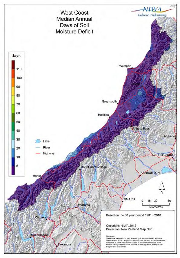
is depleted or after a period of very heavy rainfall when observed throughout the year is very low. Figure 20
the soil is at field capacity. Daily calculations are then shows region-wide variability in days of soil moisture
made of moisture lost through evapotranspiration deficit per year, which further illustrates the lack of soil
or replaced through precipitation. If the available moisture deficit that occurs throughout West Coast.
soil water becomes insufficient to maintain
evapotranspiration then a soil moisture deficit occurs
and irrigation becomes necessary to maintain plant
Table 23. Mean monthly and annual water balance summary for a soil moisture capacity of 150 mm at selected West Coast locations.
Location Jan Feb Mar Apr May Jun Jul Aug Sep Oct Nov Dec Ann
Greymouth DE 4 3 1 0 0 0 0 0 0 0 1 1 9
ND 1 1 0 0 0 0 0 0 0 0 0 0 3
RO 92 65 101 163 194 198 173 159 147 151 118 111 1671
NR 5 4 7 11 14 14 13 13 12 12 8 7 119
Haast DE 5 1 2 0 0 0 0 0 0 0 0 0 7
ND 1 0 1 0 0 0 0 0 0 0 0 0 2
RO 154 93 168 180 236 245 208 211 235 219 159 199 2307
NR 6 5 9 10 14 13 13 14 13 13 9 10 129
Hokitika DE 2 2 1 0 0 0 0 0 0 0 0 0 4
ND 0 1 0 0 0 0 0 0 0 0 0 0 1
RO 135 84 133 190 218 230 199 200 211 204 154 157 2116
NR 7 5 8 11 14 13 13 13 14 13 9 9 127
Reefton DE 10 16 7 1 0 0 0 0 0 0 3 6 44
ND 2 4 3 1 0 0 0 0 0 0 1 1 12
RO 37 16 21 87 142 172 149 141 131 121 76 57 1149
NR 3 1 2 6 12 13 12 11 11 9 6 4 90
Westport DE 7 7 4 0 0 0 0 0 0 0 2 2 22
ND 2 2 1 0 0 0 0 0 0 0 0 0 6
RO 58 38 59 124 165 182 152 147 128 121 92 83 1349
NR 4 3 5 9 13 15 14 13 12 11 8 6 111
DE: average amount of soil moisture deficit (mm)
ND: average number of days on which a soil moisture deficit occurs
RO: average amount of runoff (mm)
NR: average number of days on which runoff occurs
34You can also read