Application of GIS on Research of Horizontal Refraction in Polygonometry on Network
←
→
Page content transcription
If your browser does not render page correctly, please read the page content below
E3S Web of Conferences 227, 04003 (2021) https://doi.org/10.1051/e3sconf/202122704003
GI 2021

 Application of GIS on Research of Horizontal
 Refraction in Polygonometry on Network
 Abdusali Suyunov1,*, Shukhrat Suyunov1 and Olim Urokov1
 1
 SamSACEI, Department of Geodesy and Cartography, 140147, Samarkand, Uzbekistan

 Abstract. The article examines the influence of refraction on the results
 of measuring the horizontal angle in special places. In the conditions of the
 hot and arid climate of Uzbekistan in the polygonometric network of river
 banks, according to the results of field experiments, the new version of the
 developed methodology of the GIS makes it possible to increase the
 accuracy of measuring horizontal angles and lengths of lines. Significant
 temperature changes along the water and the coast, on rocks, in the upper
 layers of sand-concrete pavements are also explained by the properties of
 the heat and radiation balance.
 Keywords. Electronic technologies, high-precision geodetic
 measurements, the influence of refraction, atmospheric measurement,
 uneven distribution of the light beam, modern devices, positive
 opportunities.

 1 Introduction
 One of the most important reasons limiting the accuracy of measuring horizontal angles
 using modern technology of high-precision angular measurements is not instrumental
 errors, but an error called horizontal refraction of the atmospheric atmosphere caused by
 external environmental influences.
 Studying this phenomenon and eliminating its harmful effects, triangulation and
 polygonometry is the first task in science and industry to improve the accuracy of networks.
 This problem is taken into account when conducting geodetic measurements in
 developed countries, including Russia, Ukraine, Germany, the United States and other
 countries, to improve the accuracy of measurements, taking into account the horizontal
 refractive properties, which significantly affect the measurement results.
 In large-scale cartographic work, geodesy makes all the requirements related to the
 accuracy of the geodetic base, especially angular measurements, forcing to revise the newly
 created and developed systems for constructing the geodetic base, and requires the
 development of a new method.
 In this regard, one of the important tasks is to ensure that the external environment is
 not always in a stable state, but to change it from time to time in established ways.
 The new basic geodetic survey system shortens the sides of triangles and polygon
 measurements as it requires more compaction of points. As a result, we observe a slight

 *
 Corresponding author: suyunov303@inbox.ru

© The Authors, published by EDP Sciences. This is an open access article distributed under the terms of the Creative Commons
Attribution License 4.0 (http://creativecommons.org/licenses/by/4.0/).
E3S Web of Conferences 227, 04003 (2021) https://doi.org/10.1051/e3sconf/202122704003
GI 2021

 deterioration in the state of light transmission along the uneven line. In such cases, it is
 necessary to improve the accuracy of the angular measurement results. To overcome such
 problems, it is necessary to study new cases of the influence of horizontal refraction on the
 accuracy of the results of measuring horizontal angles in urban polygonometry, i.e. laws of
 subordination of the atmosphere to height..
 To accomplish these tasks, it is important to determine and improve a modern solution
 for measuring the impact of the external environment on horizontal angle measurements.
 In the Strategy for the Further Development of the Republic of Uzbekistan for 2017-
 2021, the Republic of Uzbekistan “On Geodesy and Cartography”, Decree of the President
 of the Republic of Uzbekistan dated May 31, 2017, No. UP-5065 “On Further Improving
 the Activities of the State Committee for Land Resources, Geodesy, Cartography and
 cadastre of the Republic of Uzbekistan” other regulatory documents [1].
 With the development of this area, the scientific problems of urban polygonometry
 using horizontal angle and linear distance measurements are expanding, which requires
 taking into account the effect on horizontal angle measurements in hot, very hot and dry
 climates.
 It is important and urgent to find a solution to these problems, especially in the context
 of the climate of the Karshi city of the Republic of Uzbekistan, in dry and hot climates, the
 variability of the atmosphere is very high, which leads to significant errors in the
 measurement of the horizontal angle.
 Methods for taking into account the influence of the atmosphere on measurements of
 the horizontal angle have been tested to one degree or another in the middle latitudes of the
 normative climate and in other relatively lower regions of the republic's climate, but in an
 arid climate, they have not been studied at all.
 The influence of horizontal refraction on the results of geodetic measurements was
 studied in scientific research of scientists of the republic A.S.Suyunov and T.M.Abdullaev,
 and they have achieved certain positive results [3,4,6,9].
 However, the work of the aforementioned scientists and researchers did not study the
 implementation and improvement of the accuracy required to measure these objects in
 modern new geodetic instruments, as well as its regional organization.
 Much attention in the country is paid to the construction of new buildings and structures
 on the basis of comprehensive geodetic control with high precision, accuracy and standards.
 However, no method has been developed to improve accuracy by determining the degree of
 influence of the near-earth layer of the atmosphere on the results of geodetic measurements.
 Thus, this article to some extent meets the above goals and objectives.
 Sokoba’s research on reforestation and riverbank research is based on a very short (six-
 hour) experience with a number of drawbacks [5,7,8,11].
 Therefore, the effect of refraction on geodetic measurements has not yet been studied in
 urban polygonometry.
 In fact, the solution to this question is not enough for Marchenko [5] investigated in his
 polygonometric system of wall mounting, specifying the refraction effect in this case,
 without saying a word about the effect of light refraction. At the same time, polygon paths
 along city streets and river banks are approaching additional established signs, which leads
 to the fact that horizontal angles are distorted and significantly increase.
 In particular, еhe lateral refraction effect is especially noticeable in the lower classes of
 polygonometry when it comes to the accuracy of measuring horizontal angles. [6]. The
 reason is as follows:
 (a) Polygonometry usually develops in a plane, in a closed space, that is, according to
 the temperature (density) of the air, as well as the refraction of the light beam under
 conditions of a strong influence of the air temperature below and the height of the air
 atmosphere up to 1.5 m and in places with obstacles. Especially in polygonometry of fields

 2
E3S Web of Conferences 227, 04003 (2021) https://doi.org/10.1051/e3sconf/202122704003
GI 2021

 3 and 4 and urban polygonometry, the influence of a light beam on the state “not between
 obstacles, but between obstacles” should be noted separately. Triangulation is typically
 used primarily in open, intersecting, or semi-enclosed areas, that is, in conditions where it is
 visible at all distances or partially so that light passes through the lower surface of the earth.
 b) In polygonometry, the azimuth transfer error is approximately 1.3 times greater than
 the triangulation error [2,10,12-16].
 c) In the lower classes of polygonometry, when the line length is 0.5–1 km, small, well-
 defined refractive fields have a strong refractive effect on the measured geodetic results of
 all polygonometric trajectories. Thus, the values of the effect of the refractive field in the
 lower classes of the polygonometric trajectory will be very close to the indices of the
 refractive field in polygonometry of the 1st and 2nd classes.
 The microclimatic regime in the surface layer of the atmosphere is characterized, first of
 all, by superadiabetic vertical temperature gradients during the day and nighttime inversion
 of the temperature distribution and their significant differences in the horizontal plane and
 even greater gradients in the near-surface layers.
 As is known from the courses of meteorology, the physical basis of these properties
 stems from the heat and radiation balance in the near-surface layer of the atmosphere.
 The influence of the local climate of water bodies and rivers and the microclimate of
 coastal areas is known.
 Consequently, it reduces the daily and annual amplitudes of air temperature near water
 bodies; in summer, the temperature decreases along the coast and above the water surface
 during the day, and at night it is higher than in places far from water bodies; water bodies
 heat up during the winter months, and the adjacent drylands are relatively cooled; The
 range of influence of shores stretching for tens, and sometimes hundreds of kilometers,
 depends mainly on the size of the reservoirs.
 Throughout the water and along the coast, on the rocks, in the upper layers of sand-
 concrete pavements, there are obvious temperature drops;
 Again, this is due to the properties of heat and radiation balance.
 Based on the results of Suyunov's and Abdullaev's installation of meteorological
 stations in the upper water layer in the region of 5 geodetic points (5-10 m) around the
 Koratepa reservoir, the effect of lateral refraction was determined. did not take into account
 the influence of the external environment in field experimental studies.

 2 Methods

 2.1. Study area
 In the experimental region, the refractive index n of the air atmosphere has a
 predominant effect on the horizontal temperature gradient. In coastal soil conditions,
 horizontal moisture and temperature gradients can have a significant impact on coastal
 areas. From a geodetic point of view, we found answers to the following questions to study
 and account for the effect of lateral refraction to improve the accuracy of horizontal angle
 measurements:
 a) values of horizontal gradients of temperature and humidity of air at a distance of the
 first ten meters from the surface of the earth and water of the atmosphere near the earth;
 b) in each direction, in different weather conditions, horizontal gradients of temperature
 and humidity during the day, the path of change in hours;
 c) density of the range of spatial distribution of the light beam above the surface layer of
 the atmosphere, etc.

 3
E3S Web of Conferences 227, 04003 (2021) https://doi.org/10.1051/e3sconf/202122704003
GI 2021

 The answers to these questions were found during a survey conducted by the authors in
 June 2018 and July-August 2019 at the geodetic polygon in the Khudoizod massive which
 is located in Karshi city of the Republic of Uzbekistan.

 2.2. Methods
 Points for meteorological observations were selected from open areas on the left bank of
 the Beshkent River. The glasses were set 12 meters from running water. This river flows
 out of the Beshkent Canal, not far from the Khudoizod massive (0.8-1.0 km). This place is
 distinguished by its unusual width, landscape, and natural features. Observation platforms
 of low (2-4 m) relief, complex, are located at a depth of several tens of meters wide and in
 hills. The width of the massif directly with the observation deck is 3.5 meters towards the
 lower reaches of the river, the width of the coastline is 30-35 meters, the height of the
 coastline is 3-3.5 meters. The azimuth of the river flow is 125о. It is asymmetrical on the
 left bank of the Beshkent River, stretches 1-1.5 km to the north and north-west, and is
 located at the foot of the hills, then turns into a gentle hill, therefore it is located at a
 distance of 700-900 m from Beshkent. the absolute height of the points is close to the right
 bank of the river valley and depends on the river bed. In 2018, at the main observation site,
 the temperature was measured from the earth's surface, at a height of 0.75 m, and
 temperature and humidity - at a height of 1.5 m. Atmospheric pressure, wind speed, and
 direction were also determined. The state of heaven was recorded. At the same time, air
 temperature and humidity were observed on the water surface at the above-mentioned
 heights and its readings were recorded. For this, a special boat was built and a mast was
 attached to it. Modern electronic psychrometers were installed on the masts. All
 measurements were made by the members of the expedition.
 Thus, at the aforementioned heights, meteorological data were measured at the same
 height above land and water at a distance of 3.5 m from the coast, from the water. Aneroid,
 hand-held anemometer, psychometers were used to measure meteorological elements.
 Before all measurements, the measuring instruments were inspected.
 At the same time, it was taken into account that the height of the aiming beam when
 viewing the place itself is legally greater than at ground level.
 For the measurement of meteorological elements: psychrometers-thermometers with
 fabric protection (coefficient of continuity 200 seconds) and scale values of 0.1 ° and 0.2 °
 C. Particular attention was paid to the measurement of air temperature. All thermometers
 were checked and compared every hour. Their readings were brought to the readings of a
 psychrometer installed at a height of 1.5 meters in the main zone. This method significantly
 improves the detection of gradients with psychrometers and emphasizes their accuracy. The
 reason is that, without correction by using thermometers, artificial ventilation becomes
 absolutely necessary. Finally, due to the variability of solar radiation, there will also be
 significant (up to 1 ° S) daily variability, which depends on the strength and direction of the
 wind speed.
 In each measurement, thermometers were counted three times, and the second and third
 counts were made at intervals of 2–4 min, respectively. The result is the arithmetic mean of
 these numbers. We did not measure temperature, although the science of meteorology
 recommended observing air temperature readings at microclimate altitudes (20 cm and 50
 cm).
 It should also be noted that each psychrometer has its own radiation errors, and in
 meteorology, it is generally preferable to measure gradient values with a single
 psychrometer, regardless of the fact that these measurements are not simultaneous.
 We, on the other hand, used two psychrometers and counted them simultaneously,
 which reduced radiation errors by comparing thermometers to each other every hour.

 4
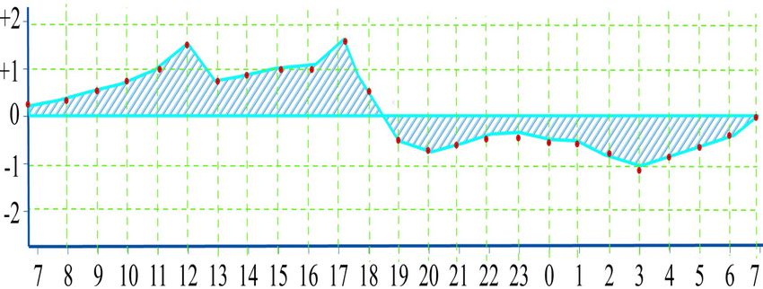
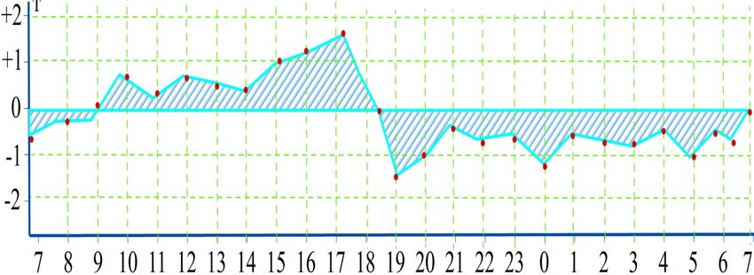
E3S Web of Conferences 227, 04003 (2021) https://doi.org/10.1051/e3sconf/202122704003
GI 2021

 Compared to the meteorological measurements of our 2019 field experiments, the
 observations made in 2018 were closely related to simultaneous angle measurements. In
 these measurements, the main observation point is located at a distance of 7 m from the
 edge of the water boundary.
 In addition, the horizontal gradient of air humidity in 2018 has not been determined. In
 2019, air temperature, humidity, and wind speed were determined.
 Accordingly, all measurements were made on two additional psychrometers.
 Psychrometers are located on the left bank of the embankment at a distance of 15 meters
 from the water and 50 meters from the station, as well as at the station on the right bank. In
 turn, in 2018, additional air temperatures were measured in the direction transverse to the
 river at a distance of 400 m from the station. During the observation, the openness of the
 sky was recorded on a five-point scale.
 All observations were usually carried out from morning to evening, and sometimes
 during the day (24 hours). To facilitate further processing and understanding, the main
 point of meteorological observations has been moved to the origin of the spatial coordinate
 system.
 The system plane coincides with the horizon plane. The main arrow is directed
 perpendicular to the stream of the river. As a result, the main axis runs in the direction of
 the riverbank, and in fact, it is a parallel line equal to the temperature and humidity of the
 air [17].
 Thus,
 е
 , , (1)

 (1) Differences in temperature and humidity are proportional to horizontal and vertical
 gradients.

 3 Results
 We can arbitrarily call gradients positive or negative if the temperature and humidity of
 this coordinate axis fall or fall in their direction. The average values of the horizontal
 temperature (t) and air humidity of interest to us are calculated using the results of
 measurements in the middle of the river and river coordinates (x = 0, u = 50 m, z = 0).
 Fig. 1 The results of field observations in 2018 are presented in the middle of the river,
 at a distance of 5 m above the water level on land and at a height of 1.5 m along the river
 bank at the water level, demonstrating a picture of daily changes in air temperature drops.
 All of the above observations were carried out with a cloudy, opaque (variable), and
 open sky (sunny weather) wind at a speed of 0.5 m / s in the direction of the river flow.
 During the day, the wind force in this direction increased significantly and reached 4-5 m/s
 [18,20].
 The air temperature difference shown in the graphs is formed by the following formula:
 ∆ = к − с (2)

 Where, TK is the air temperature on the river bank; ТC - air temperature near the
 groundwater level. These values significantly decrease in the south of the Republic of
 Uzbekistan on sunny days, to very large 2о5 C), when the sky is variable cloudy cool days
 (up to 0о,3-0о,5 C). Differences in ∆T are positive for negative values in the morning,
 evening, and night, between 7:30 am and 8:30 pm after sunrise and between 7:00 pm and
 20:00 pm before sunset. (During the field experiment, sunrise was 6:30 am and sunset was
 8:40 pm. (Fig. 1.)

 5
E3S Web of Conferences 227, 04003 (2021) https://doi.org/10.1051/e3sconf/202122704003
GI 2021

 The uneven distribution of real moisture in the atmosphere is very interesting. During
 the day, at a height of 1.5 m on the river bank, at a distance of 15 m from the river bank, the
 humidity is relatively high, the wind blows weakly in all directions up to 5 m above the
 river surface. In the morning, evening and night, on the contrary, the water on the surface
 confirms that the humidity is quite stable and very high.

 Fig. 1. The daytime observation results

 6
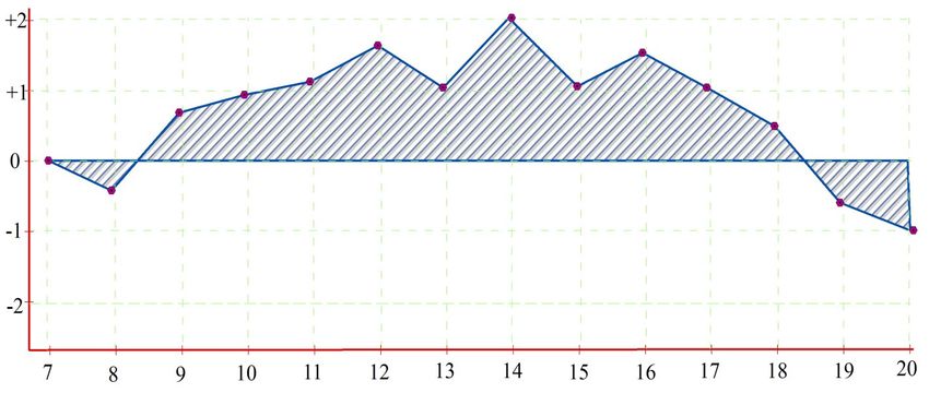
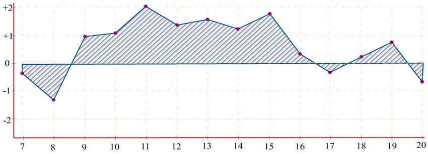
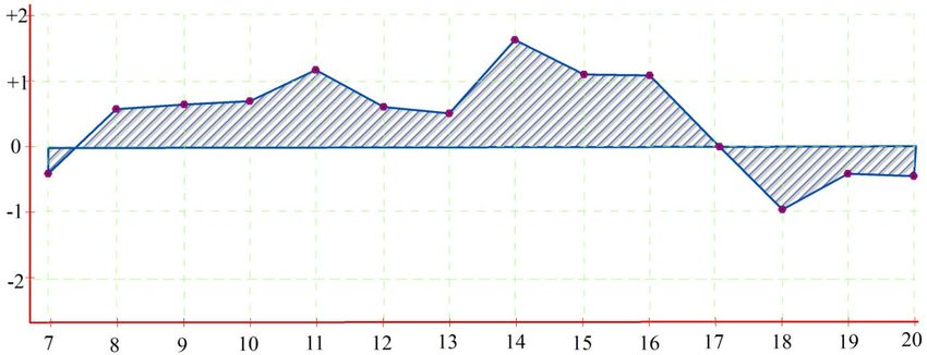
E3S Web of Conferences 227, 04003 (2021) https://doi.org/10.1051/e3sconf/202122704003
GI 2021

 Fig.2. Results of daily monitoring

 4 Discussion and conclusion
 GIS is an existing multi-faceted environmental dataset based on electronic computing
 technologies [10,19]. GIS is designed to provide easy viewing of data available at different
 levels of human economic activity. The main stage in the development of GIS is the last 7-8
 years. This is due to the fact that the computer-aided design of all work processes based on
 geographic data is organized technologically and ideologically.
 GIS integrates information of different content and distribution into one system,
 creating a coherent system for analyzing geographic data. Regardless of how important it is
 to understand and manage the various activities and resources, if GIS are not linked, this
 issue remains unresolved.
 We came to the following conclusions in the experiment:
 - based on the measured meteorological data of the atmospheric atmosphere under the
 conditions under study, the possibility of studying the regularities of the distribution
 of the microclimate that creates a refractive field has been established:
 - during the day, we showed that the influence of lateral refraction on the results of
 measuring the horizontal angle and line in hot and dry climates can be established in
 river conditions in the south of the country, every two hours of the day and in various
 climatic conditions:
 - using the meteorological elements identified in the field, the geodetic measurements
 made in the river bank polygon as corrections were applied to the lateral refraction
 results and the results were improved:
 These are new solutions used by GIS to combat external influences and improve the
 accuracy of polygon networks.

 The authors are grateful to the staff of the Department of Geodesy and Mining of the Karshi
 Engineering-Economics Institute for their contribution to the collection of scientific results in this
 article.

 7
E3S Web of Conferences 227, 04003 (2021) https://doi.org/10.1051/e3sconf/202122704003
GI 2021

 References
 1. Decree of the president of the Republic of Uzbekistan, “About the strategy for further
 development of the Republic of Uzbekistan”, PF-4947 dated February 7, 2017
 2. A. S. Suyunov, Sh. A. Suyunov, On the accuracy of geodetic measurements in the
 conditions of the Republic of Uzbekistan (2017)
 3. T. M. Abdullaev, The study of patterns of action and the search for methods of
 accounting for lateral refraction when measuring horizontal angles ( Tash STU, 2005).
 4. Sh. A. Suyunov, U.E. Karimova, Sh.Sh. Fayziev, Special volume, J. Bull. Geograph.
 Society Uzbekiston (2018)
 5. Sh. A. Suyunov, Doctoral research disser., (2018)
 6. Sh. A. Suyunov, S. A. Tashpulatov, G. Mullajanova, Modern scientific challenges and
 trends. Warsaw, 12 ( 2) (2019)
 7. А. S. Suyunov, Sh. I. Fayziyev, Intr. J. Adv. Res. Sci., Engin. Tech. 6 (11) (2019)
 8. А. S. Suyunov, Sh. A. Suyunov, G.M. Mullajanova, Intr. J. Adv. Res. Sci., Engin.
 Tech.. 6 (11) (2019)
 9. А. S. Suyunov, Sh. I. Fayziyev, Studying the experience of full breakage on the streets
 of karshi in kashkadarya region. Intr. J. Adv. Res. Sci., Engin. Tech. 6 (11) 11873-
 11875 (2019)
 10. А. S. Suyunov, Sh. A. Suyunov, G.M. Mullajanova, Аnalysis of the qualification
 developmentof natural hazards at geoecological monitiring of landslide hazardeus
 territiries. Intr. J. Adv. Res. Sci., Engin. Tech. 6 (11) 11534-11537 (2019)
 11. A. S. Suyunov, A. A Salahiddinov, Sh. A. Suyunov, Analysis of the influence of the
 atmosphere surface layer on the measurement made by electronic total stations. Intr. J.
 Adv. Res. Sci., Engin. Tech. 4 (1) 3098-3101 (2017)
 12. I. S. Trivoy, The nature of the temperature field in the city and the phenomenon of
 anamal lateral refraction. "Geoecological problems of urbanized territories" (Характер
 температурного поля городе и явление анамальной боковой рефракции.
 “Геоэкологические проблемы урбанизированных территорий”) 15-16 (1999)
 13. А. S. Suyunov, Sh.A. Suyunov, Refraction accounting methods for geodetic
 measurements (Методы учета рефракции при геодезических измерениях) 158
 (2020)
 14. O. B. Vshivkova, Profile aggregation as a means of accounting for the influence of the
 surface layer of the atmosphere with minimal costs (Профильное комплексирование
 как средство учета влияния приземного слоя атмосферы с минимальными
 затратами) 4 3-11 (2017)
 15. А. S. Suyunov, Sh. A. Suyunov, M. K. Isakov, Geodetic refraction in Central Asian.
 (Ўрта осиё шароитида геодезик рефракция) conditions Materials of the XIV
 Republican scientific-practical conference. 2 36-39 (2017)
 16. А. S. Suyunov, Sh. A. Suyunov, U. Berdikulov, A new way to take into account
 refraction in trigonometric leveling in Uzbekistan (Ўзбекистон шароитида
 тригонометрик нивелирлашда рефракцияни ҳисобга олишнинг янгича йўли). J. Irr.
 And Mel. 2 55-57 (2018)
 17. A. E. Fedorishchev, L. S. Xijak, Investigation of the temperature field in order to take
 into account refractive distortions in the boundary layer of the atmosphere.
 (Исследование температурного поля с целью учета рефракционных искажений в
 пограничном слое атмосферы). J. Geo. Car. 21 66-69 (1995)

 8
E3S Web of Conferences 227, 04003 (2021) https://doi.org/10.1051/e3sconf/202122704003
GI 2021

 18. M. Hennes, Zum Refraktionseinfluss auf terrestrische geodдtische Messungen im
 Kontext der Messtechnik und der Instrumentenentwicklung. Fldchenmanag. Und
 Bodenordn. 2 73-86 (2016)
 19. W. Gurtner, G. Beutler, The use of meteorological data in large scale GPS networks.
 Spring Meet, Baltimore. 3 23-28 (1994)
 20. P. Harzer, Berehningder Ablenrungender Lichtetrahlenin der Erdefufrein meterologiech
 – physikalische Grundlage. Publ. Der Sternwartein Kiel, 24 (1982)

 9
You can also read