Cimarron River Alluvial Aquifer Hydrogeologic Framework, Water Budget, and Implications for Future Water Availability in the Pawnee Nation Tribal ...
←
→
Page content transcription
If your browser does not render page correctly, please read the page content below
Prepared in cooperation with the Bureau of Indian Affairs and the Pawnee Nation of Oklahoma

Cimarron River Alluvial Aquifer Hydrogeologic Framework,
Water Budget, and Implications for Future Water Availability
in the Pawnee Nation Tribal Jurisdictional Area, Payne
County, Oklahoma, 2016–18

Scientific Investigations Report 2021–5073

U.S. Department of the Interior
U.S. Geological Survey
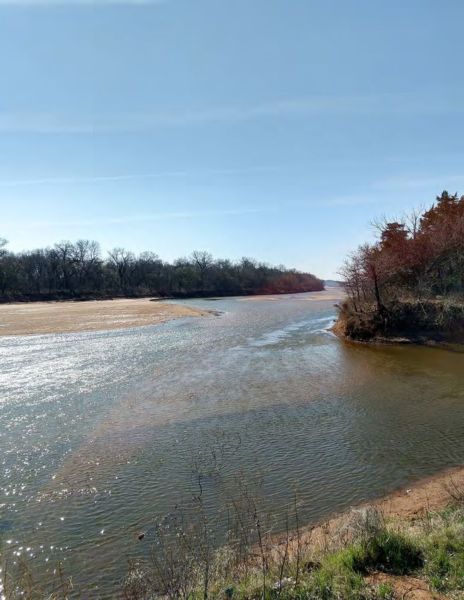
Cover. Photograph showing the Cimarron River in Payne County, Oklahoma, with the view oriented
upstream from the right bank about 3 miles north of Ripley, Okla. Photograph by Nicole Paizis, U.S.
Geological Survey, March 15, 2018.
Cimarron River Alluvial Aquifer
Hydrogeologic Framework, Water
Budget, and Implications for Future
Water Availability in the Pawnee Nation
Tribal Jurisdictional Area, Payne County,
Oklahoma, 2016–18

By Nicole C. Paizis and Adam R. Trevisan

Prepared in cooperation with the Bureau of Indian Affairs and
the Pawnee Nation of Oklahoma

Scientific Investigations Report 2021–5073

U.S. Department of the Interior
U.S. Geological Survey
U.S. Geological Survey, Reston, Virginia: 2021 For more information on the USGS—the Federal source for science about the Earth, its natural and living resources, natural hazards, and the environment—visit https://www.usgs.gov or call 1–888–ASK–USGS. For an overview of USGS information products, including maps, imagery, and publications, visit https://store.usgs.gov/. Any use of trade, firm, or product names is for descriptive purposes only and does not imply endorsement by the U.S. Government. Although this information product, for the most part, is in the public domain, it also may contain copyrighted materials as noted in the text. Permission to reproduce copyrighted items must be secured from the copyright owner. Suggested citation: Paizis, N.C., and Trevisan, A.R., 2021, Cimarron River alluvial aquifer hydrogeologic framework, water budget, and implications for future water availability in the Pawnee Nation Tribal jurisdictional area, Payne County, Oklahoma, 2016–18: U.S. Geological Survey Scientific Investigations Report 2021–5073, 49 p., https://doi.org/10.3133/ sir20215073. Associated data for this publication: Trevisan, A.R., and Paizis, N.C., 2021, MODFLOW-NWT model used for the simulation of the Cimarron River alluvial aquifer in the Pawnee Nation Tribal jurisdictional area in Payne County, Oklahoma, 2016–17: U.S. Geological Survey data release, https://doi.org/10.5066/P9WZGYQF. U.S. Geological Survey, 2019, USGS water data for the Nation: U.S. Geological Survey National Water Information System database, https://doi.org/10.5066/F7P55KJN. ISSN 2328-0328 (online)
iii

Acknowledgments
The authors wish to thank the leaders and members of the Pawnee Nation of Oklahoma
(Pawnee Nation) who made this report possible, including Walter Echo-Hawk for his assistance
with field logistics and for coordinating efforts to obtain the needed permissions to access the
land of the Pawnee Nation. The authors are grateful to the many landowners who provided
access to their property for hydrogeologic-data collection.

The authors wish to thank U.S. Geological Survey scientists Shana Mashburn and Kyle Rennell
for overseeing and assisting with the data collection.
v

Contents
Acknowledgments����������������������������������������������������������������������������������������������������������������������������������������iii
Abstract�����������������������������������������������������������������������������������������������������������������������������������������������������������1
Introduction����������������������������������������������������������������������������������������������������������������������������������������������������2
     Purpose and Scope������������������������������������������������������������������������������������������������������������������������������2
     Description of Study Area�������������������������������������������������������������������������������������������������������������������2
     Climate����������������������������������������������������������������������������������������������������������������������������������������������������4
     Land Use�������������������������������������������������������������������������������������������������������������������������������������������������4
     Groundwater Withdrawals������������������������������������������������������������������������������������������������������������������4
     Geology���������������������������������������������������������������������������������������������������������������������������������������������������6
           Quaternary Alluvium and Terrace Deposits����������������������������������������������������������������������������6
           Bedrock Units�����������������������������������������������������������������������������������������������������������������������������12
Hydrogeology�����������������������������������������������������������������������������������������������������������������������������������������������12
     Groundwater����������������������������������������������������������������������������������������������������������������������������������������12
           Groundwater Level Fluctuations���������������������������������������������������������������������������������������������13
           Potentiometric Surface�������������������������������������������������������������������������������������������������������������14
     Streamflow�������������������������������������������������������������������������������������������������������������������������������������������15
     Recharge����������������������������������������������������������������������������������������������������������������������������������������������15
           Water-Table Fluctuation Method��������������������������������������������������������������������������������������������15
           Soil-Water-Balance Code��������������������������������������������������������������������������������������������������������18
Hydrogeologic Framework of the Cimarron River Alluvial Aquifer�����������������������������������������������������20
     Aquifer Extent��������������������������������������������������������������������������������������������������������������������������������������20
           Bedrock Altitudes From Ambient Seismic Method��������������������������������������������������������������20
           Aquifer Depths and Thicknesses from Lithologic Logs�������������������������������������������������������20
     Textural and Hydraulic Properties���������������������������������������������������������������������������������������������������22
           Lithologic Logs and Percent Coarse Values��������������������������������������������������������������������������22
           Spatial Distribution of Lithologic Categories�������������������������������������������������������������������������22
Conceptual Groundwater Flow Model and Water Budget�������������������������������������������������������������������24
     Hydrologic Boundaries of the Cimarron River Alluvial Aquifer���������������������������������������������������25
     Conceptual Water Budget�����������������������������������������������������������������������������������������������������������������25
Numerical Groundwater Flow Model of the Cimarron River Alluvial Aquifer�����������������������������������27
     Model Extents and Configuration�����������������������������������������������������������������������������������������������������27
     Discretization���������������������������������������������������������������������������������������������������������������������������������������27
     Boundary Conditions of the Numerical Groundwater-Flow Model��������������������������������������������28
           Groundwater Recharge������������������������������������������������������������������������������������������������������������30
           Water-Table Evapotranspiration���������������������������������������������������������������������������������������������30
           Streamflow����������������������������������������������������������������������������������������������������������������������������������30
           Lateral Flow��������������������������������������������������������������������������������������������������������������������������������33
           Groundwater Withdrawals�������������������������������������������������������������������������������������������������������33
     Model Calibration�������������������������������������������������������������������������������������������������������������������������������34
           Calibration Parameters�������������������������������������������������������������������������������������������������������������34
           Observations Used for Calibration and Observation Weighting����������������������������������������34
           Observation Sensitivity Analysis���������������������������������������������������������������������������������������������35
           Calibration Results���������������������������������������������������������������������������������������������������������������������38
vi
Calibrated Water Budget�������������������������������������������������������������������������������������������������39
Comparison of Simulated and Observed Values���������������������������������������������������������39
Long-Term Streamflow Capture Analysis—Implications for Future Water Availability���������40
Model Assumptions and Limitations�����������������������������������������������������������������������������������������������42
Summary�������������������������������������������������������������������������������������������������������������������������������������������������������44
References Cited�����������������������������������������������������������������������������������������������������������������������������������������45
Figures
1. Map showing the Cimarron River alluvial aquifer, the Cimarron River alluvial
aquifer model extent, and the Pawnee Nation subdomain of the Cimarron River
alluvial aquifer model extent (Pawnee Nation subdomain) and data collection
sites in and near the Pawnee Nation Tribal jurisdictional area in Payne County,
Oklahoma���������������������������������������������������������������������������������������������������������������������������������������3
2. Graph showing total annual precipitation and annual mean temperature for
each year during the 1994–2019 period of record at the Perkins, Oklahoma,
Mesonet weather station near the study area, the Pawnee Nation subdomain
of the overall Cimarron River alluvial aquifer model extent, Payne County,
north-central Oklahoma���������������������������������������������������������������������������������������������������������������6
3. Pie charts showing land-cover classifications for the Pawnee Nation
subdomain of the Cimarron River alluvial aquifer model extent, 2018, Pawnee
Nation Tribal jurisdictional area, Payne County, north-central Oklahoma��������������������������7
4. Map showing land-cover classification for the Pawnee Nation subdomain of
the Cimarron River alluvial aquifer model extent, 2018����������������������������������������������������������8
5. Map showing locations of wells used for permitted groundwater withdrawals in
the model area by permitted use and permitted type�����������������������������������������������������������10
6. Map showing surficial geologic units of the overall Cimarron River alluvial
aquifer model extent in Payne County, north-central Oklahoma����������������������������������������11
7. Diagram showing a simplified aquifer schematic indicating inflows, such
as precipitation recharge and bedrock lateral flow, and outflows, such as
evapotranspiration, base-flow contributions to streams, and groundwater
withdrawals���������������������������������������������������������������������������������������������������������������������������������13
8. Graph showing depth to water at continuous-monitoring wells and daily
precipitation data from the Perkins, Oklahoma, Mesonet weather station, May
2017 to October 2018, used for the water-table fluctuation method for the use in
the model��������������������������������������������������������������������������������������������������������������������������������������14
9. Map showing potentiometric surface of the Cimarron River alluvial aquifer
model extent in Payne County, north-central Oklahoma, March 2018������������������������������16
10. Map showing bedrock altitudes and ambient seismic locations and Oklahoma
Water Resources Board well logs used to interpolate the base of the Cimarron
River alluvial aquifer�������������������������������������������������������������������������������������������������������������������21
11. Bar graph showing aquifer thickness observation values determined from
lithologic logs������������������������������������������������������������������������������������������������������������������������������22
12. Chart showing percentage of coarse material multiplier values for the
generalized lithologic categories used to obtain horizontal hydraulic
conductivity for the Cimarron River alluvial aquifer�������������������������������������������������������������22
13. Bar graph showing percentage of observations of estimated horizontal
hydraulic conductivity distributions derived from Oklahoma Water Resources
Board lithologic logs for wells completed in the Cimarron River alluvial aquifer������������24vii
14. Graphs showing monthly base flows derived using base-flow index methods
for streamflow data collected from 2016 to 2017 for selected U.S. Geological
Survey streamgages in Payne County, north-central Oklahoma, used for input
to the Cimarron River alluvial aquifer model��������������������������������������������������������������������������26
15. Map showing modeled land-surface altitudes used in the Cimarron River
alluvial aquifer that were derived from a U.S. Geological Survey digital
elevation model���������������������������������������������������������������������������������������������������������������������������29
16. Bar graph showing number of modeled land-surface altitude observations for
the Cimarron River alluvial aquifer model using 10 bins������������������������������������������������������30
17. Map showing mean recharge during 2016–17 used for the Cimarron River
alluvial aquifer steady-state simulation����������������������������������������������������������������������������������31
18. Map depicting model boundary conditions, stream reaches, and inflow points
for the Streamflow-Routing package for the Cimarron River alluvial aquifer
simulation�������������������������������������������������������������������������������������������������������������������������������������32
19. Graph showing monthly water demand as percentage of annual water use for
irrigation, public supply, and other usages for the upper Arkansas River Basin������������34
20. Map showing locations of water-table altitude observations and map identifier
and the extent of terrace deposits�������������������������������������������������������������������������������������������37
21. Bar graph showing number of saturated aquifer thickness values assigned to
model cells�����������������������������������������������������������������������������������������������������������������������������������39
22. Bar graph showing conceptual groundwater-flow model and simulated water
budget for the Pawnee Nation subdomain of the Cimarron River alluvial aquifer
model extent, with negative values indicating outflows and positive values
indicating inflows������������������������������������������������������������������������������������������������������������������������39
23. Graph showing relation between simulated and observed water-table altitudes
between alluvium and terrace deposits, as well as between transient and
steady state for the Pawnee Nation subdomain of the Cimarron River alluvial
aquifer model�������������������������������������������������������������������������������������������������������������������������������41
24. Graphs showing observed versus simulated base flows for transient
simulations of the Cimarron River alluvial aquifer model at two U.S. Geological
Survey streamgages in the Pawnee Nation subdomain of the overall model
area for the Cimarron River alluvial aquifer, Payne County, north-central Oklahoma����42
25. Map showing streamflow capture for the Pawnee Nation subdomain of the
Cimarron River alluvial aquifer model extent, Payne County, north-central
Oklahoma�������������������������������������������������������������������������������������������������������������������������������������43
Tables
1. Total annual precipitation and annual mean temperature data for each year
during the 1994–2019 period of record at the Perkins, Oklahoma, Mesonet
weather station near the study area, Pawnee Nation subdomain of the overall
Cimarron River alluvial aquifer model extent, Payne County, north-central
Oklahoma���������������������������������������������������������������������������������������������������������������������������������������5
2. Estimates of annual groundwater-withdrawal rates for the Cimarron River
alluvial aquifer model extent based on one-half of the permitted groundwater-
withdrawal rates for well permits, 2016–18������������������������������������������������������������������������������9viii
3. Seepage-run measurements in order of upstream to downstream at various
sampling locations on the Cimarron River and tributaries in the Pawnee Nation
subdomain of the overall Cimarron River alluvial aquifer model extent, Payne
County, north-central Oklahoma, March 2018�����������������������������������������������������������������������17
4. Water-table fluctuation method data used to estimate recharge in the Pawnee
Nation subdomain of the overall model area for the Cimarron River alluvial
aquifer, Payne County, north-central Oklahoma, June 2017 to October 2018�������������������19
5. Conceptual and simulated water-budget totals for the Pawnee Nation
subdomain of the Cimarron River alluvial aquifer model extent�����������������������������������������25
6. Summary statistics for modeled land-surface altitudes, bedrock altitudes,
aquifer thickness, and saturated aquifer thickness for the Cimarron River
alluvial aquifer�����������������������������������������������������������������������������������������������������������������������������28
7. Hydrologic parameters from the calibrated Cimarron River alluvial aquifer
model and from previous studies of alluvial aquifers in Oklahoma������������������������������������33
8. U.S. Geological Survey wells that provided water-table altitude observations
used for calibration of the numerical groundwater-flow model of the Cimarron
River alluvial aquifer, 2016–17���������������������������������������������������������������������������������������������������36
9. U.S. Geological Survey wells that provided water-table altitude observations
used for calibration of the numerical groundwater-flow model of the Cimarron
River alluvial aquifer, 2016–17���������������������������������������������������������������������������������������������������38
10. Residual and objective function (Φ) components for the numerical
groundwater-flow model of the Cimarron River alluvial aquifer, 2016–17�������������������������40ix
Conversion Factors
U.S. customary units to International System of Units
Multiply By To obtain
Length
inch (in.) 2.54 centimeter (cm)
inch (in.) 25.4 millimeter (mm)
foot (ft) 0.3048 meter (m)
mile (mi) 1.609 kilometer (km)
Area
acre 4,047 square meter (m2)
acre 0.4047 hectare (ha)
square mile (mi2) 259.0 hectare (ha)
square mile (mi2) 2.590 square kilometer (km2)
Volume
acre-foot (acre-ft) 1,233 cubic meter (m3)
acre-foot (acre-ft) 0.001233 cubic hectometer (hm3)
Flow rate
acre-foot per year (acre-ft/yr) 0.001233 cubic hectometer per year (hm3/yr)
cubic foot per second (ft3/s) 0.02832 cubic meter per second (m3/s)
cubic foot per day (ft3/d) 0.02832 cubic meter per day (m3/d)
gallon per minute (gal/min) 0.06309 liter per second (L/s)
inch per year (in/yr) 25.4 millimeter per year (mm/yr)
Hydraulic conductivity
foot per day (ft/d) 0.3048 meter per day (m/d)
Leakance
foot per day per foot ([ft/d]/ft) 1 meter per day per meter ([m/d]/m)
International System of Units to U.S. customary units
Multiply By To obtain
Length
millimeter (mm) 0.03937 inch (in.)
meter (m) 3.281 foot (ft)
Flow rate
meter per second (m/s) 3.281 foot per second (ft/s)
Temperature in degrees Fahrenheit (°F) may be converted to degrees Celsius (°C) as follows:
°C = (°F – 32) / 1.8.Datum Vertical coordinate information is referenced to the North American Vertical Datum of 1988 (NAVD 88). Horizontal coordinate information is referenced to the North American Datum of 1983 (NAD 83). Altitude, as used in this report, refers to distance above the vertical datum. Abbreviations BFI base-flow index DEM digital elevation model ET evapotranspiration GHB General-Head Boundary HOB Head Observation HVSR horizontal-to-vertical spectral ratio NHDPlus National Hydrography Dataset Plus NWIS National Water Information System OWRB Oklahoma Water Resources Board PEST parameter estimation tool RMSE root mean square error SFR Streamflow-Routing SWB Soil-Water-Balance USGS U.S. Geological Survey WEL Well WTF water-table fluctuation
Cimarron River Alluvial Aquifer Hydrogeologic
Framework, Water Budget, and Implications for
Future Water Availability in the Pawnee Nation Tribal
Jurisdictional Area, Payne County, Oklahoma, 2016–18

By Nicole C. Paizis and Adam R. Trevisan

                                                                 permitted groundwater-withdrawal rate allotted was used
Abstract                                                         as the estimated annual groundwater-withdrawal amount.
                                                                 Halving the permitted groundwater-withdrawal rate was done
      The Cimarron River is a free-flowing river and is a        because permitted withdrawal rates are the maximum permit-
major source of water as it flows across Oklahoma. Increased     ted rate and actual groundwater withdrawals are generally
demand for water resources within the Cimarron River allu-       appreciably lower than the maximum permitted rate. Total
vial aquifer in north-central Oklahoma (primarily in Payne       groundwater withdrawals were estimated as 1,300 acre-feet
County) has led to increases in groundwater withdrawals          per year for the Pawnee Nation subdomain. Various hydrogeo-
for agriculture, public, irrigation, industrial, and domestic    logic data were measured to assist with model development,
supply purposes. The Pawnee Nation of Oklahoma (Pawnee           including depth to bedrock and water-table altitude data. In
Nation) is particularly concerned about the sustainability of    support of the model development, analyses pertaining to
the Cimarron River alluvial aquifer and whether the aquifer      groundwater flow, groundwater/surface-water interactions,
will continue to be a viable water resource for future genera-   base flows in the Cimarron River, and lithological interpreta-
tions of Tribal members and residents. To better understand      tions in the Pawnee Nation Tribal jurisdictional area were
current (2021) water resources and possible future water         used to compute a conceptual water budget applicable to the
availability in the Pawnee Nation Tribal jurisdictional area,    2016–18 study period. A numerical groundwater-flow model
the U.S. Geological Survey, in cooperation with the Bureau of    was developed using the hydrogeologic framework of the
Indian Affairs and the Pawnee Nation of Oklahoma, compiled       Cimarron River alluvial aquifer and the conceptual water bud-
available hydrogeologic data and developed conceptual and        get. The numerical model consists of a single layer represent-
numerical groundwater-flow models for the Cimarron River         ing alluvium and terrace deposits within the alluvial aquifer
alluvial aquifer in Payne County, north-central Oklahoma,
                                                                 model area. Hydraulic conductivities were estimated and
including a focus area in the Pawnee Nation Tribal jurisdic-     modeled for the alluvium and terrace deposits in the alluvial
tional area for the 2016–18 study period.                        aquifer. Base-flow values were estimated using the base-flow
      A conceptual water budget was created to establish         index from streamflow data collected at U.S. Geological
estimates of groundwater fluxes into and out of the aquifer      Survey streamgages. Stream seepage values were derived from
through hydrologic boundaries and groundwater withdraw-          the mean 2017 base-flow index between certain streamgages.
als for use in the numerical groundwater-flow model. The         Hydraulic conductivities were specified an initial (before
conceptual water budget focuses on the alluvial aquifer,         calibration) value of 120 feet per day for the alluvium deposits
meaning that inflows include sources of water to the aquifer     and 16 feet per day for the terrace deposits.
and that outflows include sources of water out of the aquifer,        The simulated inflows in the numerical groundwater-
such as base-flow contributions to the Cimarron River. The       flow model of the Pawnee Nation subdomain were higher
conceptual water budget was constructed by using data from       than the inflows of conceptual water budget, and the simu-
2017 (the most complete year of record for each data type        lated outflows were lower than the outflows of the conceptual
included in the model) for the Pawnee Nation subdomain of        water budget. Overall, simulated base flows matched closely
the Cimarron River alluvial aquifer model extent (Pawnee         to observed base flows for the 2016 and 2017 stress peri-
Nation subdomain).                                               ods. Simulated streamflow tended to match better with the
      Groundwater withdrawals were estimated from                observed streamflow for 2017, which was the period with the
groundwater-withdrawal rate information for permanent            most data for the Cimarron River alluvial aquifer model.
and temporary permitted wells that was obtained from the
Oklahoma Water Resources Board. One-half of each annual
2 Cimarron River Aquifer Framework, Future Water Availability, Pawnee Nation, Payne County, Oklahoma, 2016–18
Streamflow capture analysis was applied to the steady- Cimarron River alluvial aquifer in Payne County, north-central
state simulation to identify areas of the aquifer where base Oklahoma, including a focus area in the Pawnee Nation Tribal
flows in the Cimarron River were most sensitive to ground- jurisdictional area.
water withdrawals. The initial base-flow value was assigned
the value obtained from streamflow-routing software used to
simulate stream outflow for the calibrated steady-state base Purpose and Scope
model. Subsequent simulations were run in each active cell in
This report documents the development of conceptual
the Pawnee Nation subdomain for a specified groundwater-
and numerical groundwater-flow models designed to assist
withdrawal rate of 180,000 cubic feet per day. The study area
water managers in evaluating water resources in and near the
that includes the Pawnee Nation subdomain is in the upper
Pawnee Nation Tribal jurisdictional area in Payne County,
Arkansas River Basin. A groundwater-withdrawal rate of
Oklahoma. Various hydrogeologic data collected to assist
180,000 cubic feet per second per day represents a 34 percent
with model development are described, including depth to
increase compared to the highest permitted groundwater-
bedrock and water-table altitude data. This report includes
withdrawal rate for the study area, which corresponds to
data and analyses pertaining to groundwater flow, including
the estimated 34 percent increase in groundwater withdraw-
an assessment of groundwater/surface-water interactions,
als predicted by 2060 for the upper Arkansas River Basin.
base flows in the Cimarron River, and lithological interpreta-
Simulated streamflow capture was highest in the alluvium
tions in the Pawnee Nation Tribal jurisdictional area that were
deposits adjacent to the Cimarron River; that is, base flow in
used to characterize the hydrogeologic framework. From
the Cimarron River decreased the most for simulated ground-
these data and analyses a conceptual water budget applicable
water withdrawals in the alluvium deposits adjacent to the
to the 2016–18 study period was developed. A numerical
Cimarron River. Streamflow capture increased as the distance
groundwater-flow model was developed using the hydrogeo-
of a well from the Cimarron River decreased in the simula-
logic framework of the Cimarron River alluvial aquifer and
tion. The northeastern part of the Pawnee Nation subdomain
the conceptual water budget. The numerical groundwater-flow
showed greater streamflow capture in a broader area; stream-
model is designed for evaluating the current (2021) water
flow in that part of the Pawnee Nation subdomain is likely
resources of the Pawnee Nation and for assessing the pos-
more sensitive to groundwater withdrawals compared to other
sible effects that proposed new water-resource development
parts of the Pawnee Nation subdomain.
(such as additional diversion of surface water and withdrawal
of groundwater) might have on future water availability. In
addition to the calibrated numerical groundwater-flow model,
Introduction future water-availability scenarios were archived and released
in a companion USGS data release (Trevisan and Paizis,
Increased demand for water resources within the 2021). The focus area for this evaluation of groundwater and
Cimarron River alluvial aquifer in north-central Oklahoma surface-water resources is the Pawnee Nation subdomain of
(primarily in Payne County, fig. 1) has led to increases in the Cimarron River alluvial aquifer model extent (hereinafter
groundwater withdrawals for agriculture, public, irrigation, referred to as the “Pawnee Nation subdomain”) (fig. 1).
industrial, and domestic supply purposes (Oklahoma Water
Resources Board [OWRB], 2019a). The Pawnee Nation of
Oklahoma (Pawnee Nation) is particularly concerned about Description of Study Area
the sustainability of the Cimarron River alluvial aquifer and The study area is mostly in Payne County in north-central
whether the aquifer will continue to be a viable water resource Oklahoma (fig. 1) (Trevisan and Paizis, 2021) and is part of
for future generations of Tribal members and residents. the upper Arkansas River Basin (OWRB, 2012). The southern
Additional industrial and agricultural groundwater withdraw- part of the Pawnee Nation Tribal jurisdictional area overlies
als and surface-water diversions have been proposed within the Cimarron River alluvial aquifer in Payne County along the
the Pawnee Nation Tribal jurisdictional area (Charles, 2014). northern banks of the Cimarron River. The Cimarron River
As new areas within the jurisdictional area are developed for originates in New Mexico and terminates at its confluence
urban, agricultural, and industrial uses, increased groundwa- with the Arkansas River east of Payne County and the Pawnee
ter withdrawals may result in decreases in available water Nation Tribal jurisdictional area. The Cimarron River is a free-
resources and potentially cause conflicts between water users. flowing river and is a major source of water as it flows across
To better understand current (2021) water resources and pos- Oklahoma. Adjoining and below the bed of the Cimarron
sible future water availability in the Pawnee Nation Tribal River are alluvium and terrace deposits that contain ground-
jurisdictional area, the U.S. Geological Survey (USGS), in water and are referred to in this report as the “Cimarron River
cooperation with the Bureau of Indian Affairs and the Pawnee alluvial aquifer” (fig. 1). Below and adjoining the alluvial
Nation, compiled available hydrogeologic data and developed aquifer are bedrock aquifers, such as the Central Oklahoma
conceptual and numerical groundwater-flow models for theIntroduction 3
97°20' 97°00' 96°40'
Skedee
36°20' Pawnee
NOBLE
Covington COUNTY Sumner
PAWNEE
GARFIELD Morrison COUNTY
Perry
COUNTY
Lucien
Maramec
Glencoe
36°10'
Orlando
Co
Sa
Quay
un
Dee
lt
Stil
cil
lwa Mud
ter
Cr
r
Stillwater Creek
ee
k
Cr Yale
Cr
Creek
ee 9
ee
k PAYNE
k
10 07163300
07162000 COUNTY
07160500 Mulhall 360429096473901
78 360339096450201
Lovell 6
Spring
3 360200096534301
Creek 2 4 5 Cabin
36°00' PERK Ripley Creek
Big
1 Cushing
iver Perkins
rron R 07161450
Cima
Coyle
Creek
reek
Langston
Sand C
07160000
Agra
Guthrie Avery
Cedar Valley Tryon
LOGAN Meridian
35°50' COUNTY LINCOLN
COUNTY
Carney
Seward Map Kendrick
area
OKLAHOMA
Stroud
Fallis
Base from U.S. Geological Survey digital data, 2015 Cimarron River alluvial aquifer boundary inferred from alluvium and
Albers Equal-Area Conic projection terrace deposits identified by Heran and others (2003)
North American Datum of 1983 Hydrography from Horizon Systems Corporation (2019)
0 4 8 12 MILES
0 4 8 12 KILOMETERS
EXPLANATION
PERK
Pawnee Nation subdomain area of the overall Perkins, Oklahoma (PERK), Mesonet weather station
Cimarron River alluvial aquifer model extent (Oklahoma Climatological Survey, 2020)
07161450
Pawnee Nation Tribal jurisdictional area U.S. Geological Survey (USGS) streamgage and
number (USGS, 2019)
Cimarron River alluvial aquifer extent
360339096450201
USGS continuous groundwater monitoring well
Overall model area for the Cimarron River and station number (USGS, 2019)
alluvial aquifer
4
Seepage-run measurement location
Figure 1. The Cimarron River alluvial aquifer, the Cimarron River alluvial aquifer model extent, and the Pawnee Nation subdomain
of the Cimarron River alluvial aquifer model extent (Pawnee Nation subdomain) and data collection sites in and near the Pawnee
Nation Tribal jurisdictional area in Payne County, Oklahoma.4 Cimarron River Aquifer Framework, Future Water Availability, Pawnee Nation, Payne County, Oklahoma, 2016–18
aquifer (known locally and referred to hereinafter as the and wetlands (0.2 percent). The land classified as crops was
“Garber-Wellington aquifer”) and the Ada-Vamoosa aquifer further divided into specific crop-cover types and included
(Ryder, 1996). winter wheat (56.9 percent), alfalfa (the predominant type of
The study area for the numerical groundwater-flow model hay) (12.0 percent), and soybeans (9.9 percent). Fallow or idle
documented in this report is the extent of the Cimarron River cropland made up 4.3 percent; combined, other types of non-
alluvium and terrace deposits between USGS streamgage alfalfa hay, corn, and rye accounted for less than 15 percent of
07161450 Cimarron River near Ripley, Okla. (hereinafter the land classified as crops.
referred to as the “Ripley streamgage”), and USGS streamgage
07163300 Cimarron River near Yale, Okla. (hereinafter
referred to as the “Yale streamgage”), an area of approxi- Groundwater Withdrawals
mately 43 square miles (mi2) that is hereinafter referred to as
Groundwater withdrawals from the Cimarron River
the “Pawnee Nation subdomain” (fig. 1). Most of the analyses
alluvial aquifer in the Pawnee Nation Tribal jurisdictional
and statistics were completed on the Cimarron River alluvium
area during 2016–18 were estimated from water-use permit
and terrace deposits in the Pawnee Nation subdomain (fig. 1).
information from the OWRB (2019a). The OWRB permits all
For model calibration purposes, the overall Cimarron River
groundwater withdrawals in Oklahoma for nondomestic use.
alluvial aquifer model extent is a 98 mi2 area that incorporates
Domestic use has a broad definition that includes withdraw-
streamflow data from USGS streamgage 07160500 Skeleton
als by a household or individual for household purposes and
Creek near Lovell, Okla. (hereinafter referred to as the “Lovell
withdrawals for small-scale farming or irrigation of an area
streamgage”) and USGS streamgage 07160000 Cimarron
not greater than 3 acres (82 OK Stat. § 105.1).
River near Guthrie, Okla. (hereinafter referred to as the
Most groundwater permits were designated as vested
“Guthrie streamgage”).
or regular. Vested permits are water-use permits that were
established before 1963 and were grandfathered into the cur-
Climate rent permit system, which was established in 1963 and most
recently updated on September 14, 2018. Regular permits are
The study area is in the humid subtropical climate divi- approved for a proportionate amount of water determined by
sion (National Oceanic and Atmospheric Administration, the maximum annual yield of the basin and the percentage
2019). From May 2016 to October 2018, daily mean tem- of the land overlying the basin that is owned or leased by the
peratures recorded at the Perkins, Okla., Mesonet weather applicant. The remaining permits are designated as tempo-
station (fig. 1), about 10 miles southwest of the study area, rary permits, which include seasonal or term permits. These
ranged from 10 to 92 degrees Fahrenheit (°F) (Oklahoma permits are typically issued for shorter timeframes (less than 1
Climatological Survey, 2020). The mean annual temperature year) and are given lower priority for withdrawals than perma-
during 1997–2019 was 60.63 °F at the Perkins, Okla., Mesonet nent or vested permits are given (82 OK Stat. § 105.13).
weather station (Oklahoma Climatological Survey, 2020) Groundwater withdrawals were estimated for this study
(fig. 2; table 1). The warmest temperatures were typically as one-half of the annual permitted groundwater-withdrawal
measured in July, and the coldest temperatures were typically rates for each well (OWRB, 2019a). Halving the permitted
measured in January (National Agricultural Statistics Service, withdrawal rate was done because permitted withdrawal rates
2018a). The mean annual precipitation was 35.32 inches are the maximum permitted rate and actual withdrawal rates
(in.) at the Perkins, Okla., Mesonet weather station during are likely appreciably less than this rate; using one-half of the
1994–2019 (Oklahoma Climatological Survey, 2020) (table 1). permitted withdrawal rate to estimate groundwater withdraw-
The wettest months were typically April and May, and the dri- als was done based on work published in a recent ground-
est months were typically January and February. Precipitation water modeling report for a similar alluvial aquifer system
accounts for most of the recharge to Cimarron River alluvial in Oklahoma (Smith and others, 2021). In their summary
aquifer (Oklahoma Climatological Survey, 2020). of groundwater use from the Salt Fork Red River aquifer in
southwestern Oklahoma during 1967–2015, Smith and others
(2021) reported that annual reported groundwater use was
Land Use about 47 percent of the annual permitted groundwater rates
for the entire period of record and about 56 percent of the
The CropScape database was used to describe land-
annual permitted withdrawal rates during 2010–15. The Salt
cover classification at a 30-meter resolution for the Pawnee
Fork Red River aquifer in southwestern Oklahoma has similar
Nation subdomain of the Cimarron River alluvial aquifer
hydrogeologic, climatic, and water-use characteristics as the
model extent (fig. 1) (National Agricultural Statistics Service,
Cimarron River alluvial aquifer described herein, and the
2018b). In 2018, the Pawnee Nation subdomain was composed
groundwater modeling dynamics of the two alluvial aquifers
primarily of the following land-use types: grassland/pasture
are similar. Smith and others (2021) reported that halving the
(45.3 percent), forest (23.5 percent), and crops (17.5 percent)
withdrawal rate improved model stability. Halving the with-
(figs. 3 and 4). The remaining land-use types were open water
drawal rate also improved model stability for this assessment
(6.7 percent), developed (5.5 percent), barren (1.3 percent),Introduction 5
Table 1. Total annual precipitation and annual mean temperature data for each year during the 1994–2019 period of record at the
Perkins, Oklahoma, Mesonet weather station (Oklahoma Climatological Survey, 2020) near the study area, Pawnee Nation subdomain of
the overall Cimarron River alluvial aquifer model extent, Payne County, north-central Oklahoma.
[--, not available]
Year Total annual precipitation, in inches Annual mean temperature, in degrees
Fahrenheit
1994 33.52 --
1995 42.50 --
1996 22.16 --
1997 35.72 62.18
1998 39.87 62.27
1999 37.52 61.48
2000 34.44 60.22
2001 32.08 60.97
2002 33.94 59.35
2003 32.29 59.82
2004 34.28 60.01
2005 30.93 60.74
2006 24.90 62.50
2007 51.24 60.22
2008 39.64 59.27
2009 37.27 59.08
2010 34.30 59.99
2011 26.33 61.86
2012 24.07 63.65
2013 39.16 58.56
2014 27.37 59.09
2015 42.22 60.57
2016 29.23 62.28
2017 41.41 61.56
2018 39.01 59.48
2019 53.01 59.28
Mean 35.32 60.63
Standard deviation 7.52 1.37
of the Cimarron River alluvial aquifer. The estimated ground- The number of surface-water permits was low for the
water withdrawal rates totaled 2,956 acre-feet per year (acre- Cimarron River alluvial aquifer model extent. Only a few
ft/yr) for the Cimarron River alluvial aquifer model extent locations had permitted surface-water diversions, and all
(fig. 1; table 2). Considering the combined total for permanent the permits that were used were active from 1950 to 2018
and temporary permits, the estimated groundwater withdraw- (OWRB, 2019b). The permitted surface-water withdraw-
als of 1,443 acre-ft/yr for irrigation accounted for the majority als were on tributaries to the Cimarron River that were not
of total withdrawals in the Cimarron River alluvial aquifer simulated in the model. Because the locations of the permitted
model extent, followed by 774 acre-ft/yr for other withdrawals surface-water withdrawals were not simulated in the model,
and 739 acre-ft/yr for public-supply withdrawals (table 2). The surface-water withdrawals were not incorporated into the
groundwater withdrawals for the Pawnee Nation subdomain model or used to estimate surface-water withdrawal rates.
represent about 40 percent of the total withdrawals for the
entire model extent (table 2).6 Cimarron River Aquifer Framework, Future Water Availability, Pawnee Nation, Payne County, Oklahoma, 2016–18
100 100
EXPLANATION
Total annual precipitation, in inches
Annual mean temperature, in degrees Fahrenheit
80 Mean annual precipitation from 1994 to 2019, in inches,
80
and shaded area 1 standard deviation from mean
Mean annual temperature from 1997 to 2019, in degrees Fahrenheit,
and shaded area 1 standard deviation from mean
Temperature, in degrees Fahrenheit
60
Precipitation, in inches
60
40 40
20 20
0 0
1994
1995
1996
1997
1998
1999
2000
2001
2002
2003
2004
2005
2006
2007
2008
2009
2010
2011
2012
2013
2014
2015
2016
2017
2018
2019
Year
Figure 2. Total annual precipitation and annual mean temperature for each year during the 1994–2019
period of record at the Perkins, Oklahoma, Mesonet weather station (Oklahoma Climatological Survey,
2020) near the study area, the Pawnee Nation subdomain of the overall Cimarron River alluvial aquifer
model extent, Payne County, north-central Oklahoma.
Geology Quaternary Alluvium and Terrace Deposits
The geologic units in the Pawnee Nation subdomain The Quaternary-age deposits consist of alluvium and
include Quaternary-age alluvium and terrace deposits and terrace deposits and dune sand. These deposits unconformably
Permian- and Pennsylvanian-age sedimentary bedrocks (Heran overlie the Permian-age geologic units (fig. 6). The alluvium
and others, 2003, fig. 6). The surface formations include Upper deposits result from repeated cycles of river erosion and
Pennsylvanian- and lower Permian-age formations overlain by redeposition of detrital sediments (Reed and others, 1952).
thin Quaternary-age sediments (fig. 6). The surficial geologic The terrace deposits are composed of interlayered lenses of
units dip gently westward, progressively exposing younger clay, sand, and poorly sorted sand and gravel (Shelton and
beds in that direction (Shelton and others, 1985). In the area of Noble, 1974). These deposits were laid down by the ancestral
the current study, unconformities were a common occurrence Cimarron River as it traveled southwesterly down the regional
during the Paleozoic (Shelton and others, 1985). The depo- dip of the underlying Permian-age units (Reed and others,
sitional environment ranged from alluvial to shallow marine 1952). Thicknesses of the terrace deposits range from 0 to 120
(Nakayama, 1955; Greig, 1959; Shelton and others, 1985). feet (ft); variations of thickness occur as a result of erosional
features in the underlying Permian-age beds and deposition
and erosion of terrace deposits (Reed and others, 1952).
The Cimarron River alluvial aquifer alluvium and
terrace deposits range in thickness from 20 to 120 ft. The
deposits consist primarily of sand, gravel, silt, and clayIntroduction 7
1.0
A
4.3 2.4 9.9
6.5
12.0
2.6
4.4
56.9 B
1.3
6.7
17.5 5.5
Crop-cover type, 2018, in percent
EXPLANATION 23.5
Land-cover classification for the Pawnee Nation
subdomain of the Cimarron River alluvial aquifer
extent, 2018 (National Agricultural Statistics Service,
2018b) 45.3
Crop-cover type Land-use type
Winter wheat Forest
Soybeans Barren
Corn Developed 0.2
Other Grassland/
pasture
Fallow/idle
cropland Open water
Land-use type, 2018, in percent
Other hay/non- Wetlands
alfalfa
Crops
Alfalfa
Rye
Double crop winter
wheat/soybeans
Figure 3. Land-cover classifications for the Pawnee Nation subdomain of the Cimarron River alluvial aquifer model extent,
2018, Pawnee Nation Tribal jurisdictional area, Payne County, north-central Oklahoma. A, Crop-cover type. B, Land-use type.
(Bingham and Bergman, 1980). Occasional sand dunes with sand is tan to brownish red and characterized by horizontal
large-scale crossbedding are also present on the floodplain bedding and small-scale crossbedding (Noble, 1973; Shelton
along the Cimarron River (Bingham and Bergman, 1980). and Noble, 1974).
Where alluvium deposits are exposed along the Cimarron
River, sand and gravel with interbeds of clay are usually found
in a fining upward sequence (Shelton and others, 1985). The8 Cimarron River Aquifer Framework, Future Water Availability, Pawnee Nation, Payne County, Oklahoma, 2016–18
97°20' 97°00' 96°40'
Lake
Perry
PAWNEE COUNTY
NOBLE COUNTY
Lake
McMurtry
36°10'
Lake
Carl Blackwell
PAYNE COUNTY
36°00'
Lake
Langston
LOGAN COUNTY
LINCOLN COUNTY
35°50'
Stroud
Lake
Base from U.S. Geological Survey Hydrography from Horizon Systems Corporation (2019)
1:400,000-scale data (2015) 0 3 6 9 12 MILES
Albers Equal-Area Conic projection Map area
North American Datum of 1983
0 3 6 9 12 KILOMETERS
OKLAHOMA
EXPLANATION
Land-cover classification for the Cimarron River
alluvial aquifer extent, 2018 (National Agricultural
Statistics Service, 2018b)
Forest Open water
Barren Wetlands
Developed Crops
Grassland/
Pawnee Nation
pasture
subdomain
Figure 4. Land-cover classification for the Pawnee Nation subdomain of the Cimarron River alluvial aquifer model extent, 2018
(National Agricultural Statistics Service, 2018b).Introduction 9
Table 2. Estimates of annual groundwater-withdrawal rates for the Cimarron River alluvial aquifer model extent based on one-half of
the permitted groundwater-withdrawal rates for well permits, 2016–18.
[Permitted groundwater-withdrawal rates from Oklahoma Water Resources Board (2019a). --, not applicable or unknown]
Permit number by permitted use and permitted type Permit map identifier Estimated annual Estimated annual
(fig. 5) withdrawal rates withdrawal rates for
for the Cimarron the Pawnee Nation
River alluvial aquifer subdomain, in acre-
model extent, in feet per year
acre-feet per year
Irrigation, permanent -- 876.0 700.0
19370013 1 45.0 --
19530461 2 20.0 --
19560686 3 11.5 --
19570107 4 20.0 --
19570211 5 18.0 --
19590167 6 100.0 100.0
19630415 7 25.0 25.0
19670649 8 1.0 --
19700282 9 7.5 --
19720129 10 575.0 575.0
19541085A 11 53.0 --
Irrigation, temporary -- 567.0 14.0
19780572 12 179.0 --
19900514 13 14.0 14.0
19910564 14 65.0 --
19930537 15 169.0 --
19930583 16 140.0 --
Public supply, permanent -- 396.0 218.5
19200001 17 218.5 218.5
19570232 18 90.0 --
19680217 19 47.5 --
19710526 20 40.0 --
Public supply, temporary -- 343.0 100.0
19750762 21 50.0 50.0
19780536 22 50.0 50.0
19840607 23 40.0 --
19920525 24 115.0 --
19950599 25 88.0 --
Other, permanent -- 693.0 141.0
19590150 26 10.5 10.5
19680328 27 552.0 --
19690142 28 130.5 130.5
Other, temporary -- 81.0 0.0
19880503 29 1.0 --
20090503 30 80.0 --
Total -- 2,956 1,17410 Cimarron River Aquifer Framework, Future Water Availability, Pawnee Nation, Payne County, Oklahoma, 2016–18
97°20' 97°15' 97°10' 97°05' 97°00' 96°55' 96°50' 96°45' 96°40'
36°15' NOBLE
COUNTY PAWNEE
COUNTY
36°10'
Sti
llw
ate
rC
ree
k
36°05' 17
17
21
28
PAYNE 6 26 6 28
COUNTY 13
7
10
16 22
36°00' 25 15
20 23 5 4
24
12 3 iver 18 14
rron
R 9 1
Cima 29 27 8
30 19
2
11
35°55'
LOGAN
COUNTY
LINCOLN
COUNTY
35°50'
Base from U.S. Geological Survey digital data, 2015 Hydrography from Horizon Systems Corporation (2019)
Albers Equal-Area Conic projection 0 3 6 9 12 MILES Cimarron River alluvial aquifer boundary inferred from alluvium
North American Datum of 1983 and terrace deposits identified by Heran and others (2003)
0 3 6 9 12 KILOMETERS
Map area
EXPLANATION
OKLAHOMA
Pawnee Nation subdomain area of the overall Groundwater well, by permitted use and permitted
Cimarron River alluvial aquifer model extent type and map identifier (table 2)
Cimarron River alluvial aquifer extent Irrigation, permanent Other, temporary
Overall model area for the Cimarron River Irrigation, temporary Production well, permanent
alluvial aquifer Production well, temporary
Other, permanent
Figure 5. Locations of wells used for permitted groundwater withdrawals in the model area by permitted use and permitted type
(Oklahoma Water Resources Board, 2019a).Introduction 11
97°20' 97°00' 96°40'
PAWNEE COUNTY
NOBLE COUNTY
36°10'
PAYNE COUNTY
36°00'
Qt
Ipv
Qal Ipa Ipva
LINCOLN
COUNTY
LOGAN COUNTY Ipo
Pw
35°50'
Pg
Base from U.S. Geological Survey Surficial geology from Heran and others (2003)
0 3 6 9 12 MILES
1:400,000-scale digital data, 2015 Hydrography from Horizon Systems Corporation (2019)
Albers Equal-Area Conic projection
North American Datum of 1983 0 3 6 9 12 KILOMETERS
Map area
EXPLANATION OKLAHOMA
Quarternary Pennsylvanian
Alluvium (Qal) Oscar Group (Ipo)
Terrace (Qt) Vanoss Group (Ipv)
Permian Ada Formation (Ipa)
Garber Sandstone of the Vamoosa Group (Ipva)
Sumner Group (Pg)
Wellington Formation of Pawnee Nation subdomain
the Sumner Group (Pw)
Figure 6. Surficial geologic units of the overall Cimarron River alluvial aquifer model extent.12 Cimarron River Aquifer Framework, Future Water Availability, Pawnee Nation, Payne County, Oklahoma, 2016–18
Bedrock Units 200 to 600 ft thick (Garden, 1973). The Ada-Vamoosa aquifer
consists of the Ada Formation and the Vamoosa Formation.
Permian- and Pennsylvanian-aged bedrock units under- In the Pawnee Nation subdomain, the Ada-Vamoosa aquifer
lie the study area. There are two bedrock aquifer units in the dips to the west and has more water-use development potential
area as defined by the OWRB (2019a), the Garber-Wellington than any other bedrock-unit aquifer in the study area (USGS,
aquifer (contained in the Garber Sandstone and Wellington 1966). There are many small towns and industries that pump
Formation of the Sumner Group [hereinafter referred to water from wells that tap the Ada-Vamoosa aquifer; the yield
respectively as the “Garber Sandstone” and the “Wellington from these wells ranges from 3 to 100 gallons per minute
Formation”]) and the Ada-Vamoosa aquifer (contained in the (USGS, 1966).
Ada Formation and Vamoosa Group) (fig. 6). Pennsylvanian-
age rocks outcrop in eastern Payne County, near the Cimarron
River; these rock outcrops are overlain by the Permian-aged
bedrocks (USGS, 1966). Hydrogeology
In the western part of the study area, Permian-age rocks
outcrop and underlie the Cimarron River alluvium and terrace This section describes the hydrogeology of the Cimarron
deposits. The Garber Sandstone is mostly brownish orange to River alluvial aquifer and the hydrology of the overlying
reddish brown, fine- to medium-grained quartzose sandstone, Cimarron River and its tributaries. This information was
with a mean thickness of 600 ft (Bingham and Bergman, used to create the conceptual groundwater-flow model for the
1980). The Wellington Formation, the oldest formation of the Cimarron River alluvial aquifer in the Pawnee Nation Tribal
Sumner Group (Ryder, 1996), consists of sandstone, reddish- jurisdictional area, which in turn provided a means for deter-
brown shale and mudstone, with a mean thickness of 850 ft mining a simplified water budget for the aquifer.
(Shelton, 1973). Dolomite lenses developed locally in the
middle of the Wellington Formation (Logan and others, 1964). Groundwater
The Garber Sandstone and Wellington Formation compose
the Garber-Wellington aquifer, a major aquifer in the central Groundwater is defined as water in the saturated zone
part of Oklahoma, but this aquifer is not tapped by large wells between the water table and the underlying confining unit
in the Cimarron River Basin because of the high percentage (Darcy, 1856). Groundwater flows from areas of high hydrau-
of shale. A major groundwater basin (aquifer) is defined by lic head to areas of low hydraulic head throughout porous
the OWRB (2012) as a distinct underground body of water sediment in the Cimarron River alluvial aquifer as described
overlain by contiguous land and having substantially the same by Darcy’s law (Darcy, 1856). Groundwater is introduced
geological and hydrological characteristics. The Garber and into the aquifer (inflows) by recharge from precipitation
Wellington Formations dip westward, underlying the alluvial events, seepage (surface water inflows) from losing reaches
and terrace deposits (fig. 6) (Garden, 1973). of streams, and groundwater lateral flow from the adjacent
The Oscar Group is of Pennsylvanian age and crops out bedrock aquifers (Domagalski and Johnson, 2012) (fig. 7). A
in the study area from west to east (fig. 6) (Garden, 1973). In “losing reach” refers to a stream reach where there is likely
the study area, the Oscar Group is composed of red, brown, a net outflow of water from the stream into the underlying
and gray shale and brownish orange fine-grained cross-bedded groundwater system, whereas a “gaining reach” refers to a
sandstone. Arkosic sandstone is present in the southern extent stream reach where there is likely a net inflow of water from
of the Oscar Group. The Oscar Group has a mean thickness the groundwater system into the stream (Winter and others,
of 500 ft (Bingham and Bergman, 1980). The Vanoss Group 1998). Outflows of groundwater include groundwater with-
consists of alternating layers of limestone and shale with drawn by wells, seepage into gaining reaches of streams,
fine-grained arkosic sandstone (Shelton and others, 1985). The lateral flows into the surrounding bedrock, and evapotranspira-
geologic units that make up the Vanoss Group act as a mini- tion (ET) (Lohman and others, 1972) (fig. 7).
mally productive water-bearing unit that yields less than 25 Precipitation accounts for most of the recharge to the
gallons per minute (Garden, 1973). According to the OWRB Cimarron River alluvial aquifer. In general, only a small
(2012), a minor aquifer is defined as a distinct underground amount of total precipitation becomes groundwater; before it
body of water overlain by contiguous land and having sub- can infiltrate the alluvial aquifer, most precipitation is lost to
stantially the same geological and hydrological characteris- ET or surface runoff (Lohman and others, 1972). Groundwater
tics but containing less water compared to a major aquifer. is discharged from the aquifer by seepage into the Cimarron
The Ada Formation underlies the Vanoss Group and consists River and its perennial tributaries, meaning that the stream
of shale and lenticular sandstones and thin limestone beds. derives part of its streamflow from groundwater and making
The fine-grained sandstones in the Ada Group function as a the Cimarron River a gaining stream throughout most of its
minor aquifer (Garden, 1973). The Vamoosa Formation is the extent (Lohman and others, 1972). Groundwater is also dis-
farthest east of all of the rock units that outcrop in the study charged from the alluvial aquifer by seepage into the Permian-
area and consists of thin to massive layers of fine- to coarse- age geologic units underlying it; evidence of seepage into the
grained sandstone and sandy silty shale ranging from about underlying geologic units has been documented in isolatedYou can also read