Damage induced by the 25 April 2015 Nepal earthquake in the Tibetan border region of China and increased post-seismic hazards - NHESS
←
→
Page content transcription
If your browser does not render page correctly, please read the page content below
Nat. Hazards Earth Syst. Sci., 19, 873–888, 2019
https://doi.org/10.5194/nhess-19-873-2019
© Author(s) 2019. This work is distributed under
the Creative Commons Attribution 4.0 License.

Damage induced by the 25 April 2015 Nepal earthquake in the
Tibetan border region of China and increased post-seismic hazards
Zhonghai Wu1 , Patrick J. Barosh2,a , Guanghao Ha1 , Xin Yao1 , Yongqiang Xu3 , and Jie Liu4
1 Institute of Geomechanics, Chinese Academy of Geological Sciences, Beijing 100081, China
2 P.J. Barosh and Associates, 103 Aaron Avenue, Bristol, RI 02809, USA
3 China Institute of Geo-environment Monitoring, Beijing 100081, China
4 National Administration of Surveying, Mapping and Geoinformation, Beijing 100830, China
a visiting scientist at: Chinese Academy of Geological Sciences, Beijing 100081, China

Correspondence: Zhonghai Wu (wuzhonghai@geomech.ac.cn)

Received: 2 July 2018 – Discussion started: 27 July 2018
Revised: 8 March 2019 – Accepted: 16 March 2019 – Published: 18 April 2019

Abstract. The seismic effects in Nyalam, Gyirong, Tingri          1   Introduction
and Dinggye counties along the southern border of Tibet
were investigated during 2–8 May 2015, a week after the           On 25 April 2015 at 14:11:26 MGT+8 (Beijing time), a great
great Nepal earthquake along the Main Himalaya Thrust.            Ms 8.1 (Mw 7.8) earthquake struck Nepal and adjacent re-
The intensity was VIII in the region and reached IX at two        gions, killing more than 8800 people and injuring more than
towns on the Nepal border, resulting in the destruction of        23 000. The epicenter was near Pokhara, 77 km northwest of
2700 buildings, seriously damaging over 40 000 others, while      the capital of Kathmandu, and the hypocenter was at a depth
killing 27 people and injuring 856 in this sparsely populated     of 10–24 km. Many aftershocks of magnitude 4.5 Mw or
region. The main geologic effects in this steep rugged re-        greater followed, of which a Ms 7.5 (Mw 7.3) aftershock oc-
gion are collapses, landslides, rockfalls, and ground fissures,   curred after 17 days on 12 May 2015 at 15:05. This epicenter
many of which are reactivations of older land slips. These did    was near the Chinese border 77 km east–northeast of Kath-
great damage to the buildings, roads, and bridges in the re-      mandu, and the hypocenter was at a depth of 12–16 km.
gion. Most of the effects are along four incised valleys which       The main earthquake occurred on the south slope of the
are controlled by N-trending rifts and contain rivers that pass   Himalaya Mountains and formed a 120–140 km long and
through the Himalaya Mountains and flow into Nepal; at            about 80 km wide rupture zone with a dip slip of 3.5–5.5 m,
least two of the larger aftershocks occurred along the normal     which shows an expansion from west to east (USGS, 2015a,
faults. And, the damage is not related to the faulting of N-      b; IRIS, 2015). The aftershock distribution, the focal mech-
trending rifts but rather is distributed along the intensity of   anism solution, and the source rupture inversion suggest that
Nepal earthquake. Areas weakened by the earthquake pose           the earthquake was a release of built up strain along the Main
post-seismic hazards. Another main characteristic of dam-         Himalaya Thrust (MHT) fault zone and part of the ongoing
age is the recurrence of the old landslide and rockfalls. In      process of the Indian Plate underthrusting the Eurasian Plate
addition, there is an increased seismic hazard along active N-    (Fig. 1). This was the strongest seismic event since the 2005
trending grabens in southern Tibet due to the shift in stress     Ms 7.8 Pakistan Kashmir earthquake, which also occurred
resulting from the thrust movement that caused the Nepal          along the Main Himalaya Thrust. These earthquakes may in-
earthquake. NW-trending right-lateral strike-slip faults also     dicate that the seismic activity along the thrust is entering a
may be susceptible to movement. The results of the findings       new active phase.
are incorporated in some principle recommendations for the           The earthquake affected Nepal, northern India, Pakistan,
repair and reconstruction after the earthquake.                   Bhutan, and southern Tibet. The main damage characteristics
                                                                  have been reported for Nepal (Bijukchhen et al., 2017; Yun
                                                                  et al., 2015). However, there was a lack of damage investi-

Published by Copernicus Publications on behalf of the European Geosciences Union.
874                                                      Z. Wu et al.: Damage induced by the 25 April 2015 Nepal earthquake

Figure 1. Principal active faults and historic earthquakes in the Himalaya Mountains, Tibetan Plateau, and neighboring areas. The earth-
quake data are from the Science and Technology Committee and the archives in Xizang Autonomous Region (1982), Bilham (2004), and
Avouac (2007). GPS data are from Bettinelli et al. (2006). The focal mechanism solution data are from USGS (2015a, b), the Institute
of Geophysics„ China Earthq. Admin. (2015), and the China Earthquake Administration (2015). Circled numbers denote rifts in southern
Tibet as follows: (1) Cona–Oiga rift, (2) Yadong–Gulu rift, (3) Dinggye–Xainza rift, (4) Gangga–Tangra Yumco rift, (5) Nyalam–Coqên
rift, (6) Zhongba–Gêrzê rift, (7) Kunggyu Co–Yagra rift, and (8) Burang–Gêgyai rift. Thrust and strike-slip faults are denoted as follows:
MFT, Main Frontal Thrust fault of Himalaya; KKF, Karakorum fault; GCF, Gyaring Co fault; BCF, Beng Co fault; GZF, Ganzi fault; XSF,
Xianshuihe fault; KLF, Kunlunshan fault; LMF, Longmenshan fault; LCF, Longmu Co fault; KXF, Kangxiwa fault; AFT, Altyn Tagh fault;
and HYF, Haiyuan fault. Numbers 1–9 denote the M ≥ 6.8 historic earthquake epicentral areas in southern Tibet: 1 – 1411 M 8.0 Damxung–
Yangbajain; 2 – 1806 M 7.5 Cona; 3 – 1883 M 7.0 Burang; 4 – 1901 M 6.8 Nyêmo; 5 – 1909 M 6.8 Nagarze; 6 – 1915 M 7.0 Sangri; 7 –
1934 M 7.0 Gomang Co of Xainza; 8 – 1951 M 8.0 Beng Co of Nagqu; and 9 – 1952 M 7.5 Gulu of Nagqu.

gation in China, which is the focus of this paper. In China            ter the main shock, in order to quickly understand the earth-
the tremors were felt in Xigazê and Lhasa to the north and             quake effects and potential future threats to provide a basis
over an area of 300 000 km2 but were strongest in the China–           for the post-earthquake reconstruction. The group then held
Nepal border area, which is only about 40 km (Figs. 1, 2)              meetings with the local governments to present their findings
from the epicenter (Table 1). Despite the great loss of life           and recommendations. This paper is a brief summary of the
in Nepal, the disaster only caused 27 deaths, 856 injuries,            direct effects observed in the field and an investigation into
and 3 missing in China, although the damage was exten-                 the delayed effects that may cause just as much damage.
sive. About 300 000 people were affected, and the direct eco-
nomic loss was more than RMB 33 000 million (USD 5.178
billion). Fortunately, the border area has a low population            2   Seismic-geological setting
density, and the earthquake occurred in the afternoon when
many were outside, otherwise the casualty and economic loss            The Tibetan Plateau is well known for its numerous E–W to
would have been much higher. Due to the rapid response of              NW, north-dipping thrust faults that facilitated its rise as the
the local governments, displaced people were soon resettled            India Plate collided and was thrust beneath it. Most of the up-
in southern Tibet.                                                     lift occurred by the Miocene (Dewey et al., 1988; Wu et al.,
   An emergency seismic hazard investigation group of                  2008) and the majority of the thrust faults came to a stop as
12 people was organized by the Ministry of Land and Re-                the movement evolved and concentrated along fewer strike-
sources to survey the hardest hit four counties of Nyalam,             slip faults, which remain very active and capable of great
Gyirong, Tingri, and Dinggye during 2–8 May, a week af-                earthquakes (Armijo et al., 1989; Fig. 1). However, thrusting

Nat. Hazards Earth Syst. Sci., 19, 873–888, 2019                                 www.nat-hazards-earth-syst-sci.net/19/873/2019/
Z. Wu et al.: Damage induced by the 25 April 2015 Nepal earthquake                                                                          875

Figure 2. Principal active faults and the distribution of seismic intensity of the 2015 Nepal earthquake in the southern Tibet region. Epicentral
data are from the USGS, and seismic intensity data are from the China Earthquake Administration. The numbers and names of the principal
S–N-trending rifts in southern Tibet are same as on Fig. 1. The green circles show the sites of which intensities are from the China Earthquake
Administration, and yellow circles show the spots of which intensities are resulted from our field investigation. The survey spots are denoted
as follows: (1) Rema Village, (2) Jifu Village, (3) Chongse Village, (4) Guoba Village, (5) Kodari, Nepal, (6) Lixin Village, (7) Bangse
Village, (8) Zhuobude Village, and (9) Natang Village.

remains dominant in the collision zone at the southern border              3   Methods and data
of Tibet, south of the Himalaya Mountains, with the contin-
ued northward movement of India. Here the greatest activity
                                                                           The intensity was evaluated using the Chinese seismic inten-
occurs along the very shallow north-dipping Main Himalaya
                                                                           sity scale (China Earthquake Administration, GB/T 17742-
Thrust, which gave rise to the Nepal earthquake and has a
                                                                           2008, 2008) (CSIS), which is a revised national standard
long history of great earthquakes along its length (Fig. 1).
                                                                           implemented in 2009, that has 12◦ of intensity. This was
Less generally known are a series of nearly N–S-trending
                                                                           modified from the GEOFIAN (Medvedev) scale, that in turn
normal faults and grabens to the north of the great thrust that
                                                                           was adapted from the Modified Mercalli scale and is closely
complement some of the movement across it. These also are
                                                                           aligned with it, except in the lower units, and is approxi-
capable of producing significant earthquakes, although they
                                                                           mately the same in the higher units reported on herein. The
are much shorter in length (Wu et al., 2011). This array of
                                                                           latest CSIS scale revision added an additional building type
active faults plus a set of NW right-lateral strike-slip faults,
                                                                           for evaluation in reflecting newer construction in the country
which may aid extension, constitute the seismic framework
                                                                           (detailed information is provided in the Supplement).
of the region.
                                                                              A broad region of southern Tibet was affected by the earth-
   The China–Nepal border region is located on the south
                                                                           quake, but the sparse population and difficult terrain did not
slope of the Himalaya Mountains close to the Main Himalaya
                                                                           permit the felt area to be defined well. Most isoseismals
Thrust and contains many active normal faults that control
                                                                           for the lower intensities were compiled by the China Earth-
the transverse valleys that lead into Nepal. The high, rugged,
                                                                           quake Administration, which made a quick, overall survey
steep topography and the well-developed incised river val-
                                                                           of towns in order to assess the damage (Fig. 1). However, a
leys in this region further amplify the destruction caused by
                                                                           detailed field survey, reported below, was made in the most
earthquakes. Therefore, it is not strange that southern Tibet
                                                                           affected region. The principal effects of the earthquakes are
was greatly affected by the Nepal earthquake.
                                                                           the damage suffered by structures, highways, and bridges and
                                                                           the landslides, collapses, and rockfalls. The landslips caused

www.nat-hazards-earth-syst-sci.net/19/873/2019/                                       Nat. Hazards Earth Syst. Sci., 19, 873–888, 2019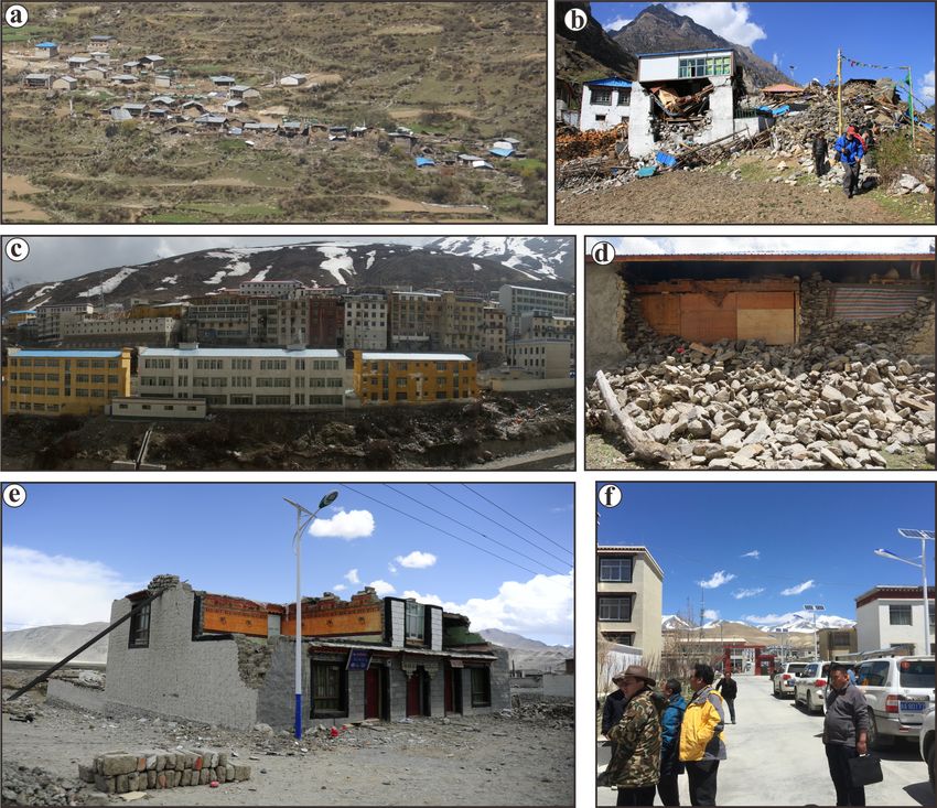
876                                                         Z. Wu et al.: Damage induced by the 25 April 2015 Nepal earthquake

Table 1. Location of surveyed sites of earthquake intensity in south-   addition to blocking river valleys and forming reservoirs that
ern Tibet. The .kmz file for these sites and some photos of typical     threatened downstream communities. It was only a massive
housing damage are given in the Supplement.                             emergency effort by the government that prevented addi-
                                                                        tional major calamities. Several small dams were formed by
    Site                Coordinates            Intensity   Notes        the Nepal earthquake but no large ones that necessitated an
    Lhasa City          29.65◦ N, 91.12◦ E     III         felt area    emergency excavation, although the threat remains.
    Xaitongmoin Town    29.432◦ N, 88.259◦ E   III         felt area       The perception of the earthquake, damage to buildings of
    Xigazê City         29.27◦ N, 88.88◦ E     IV          felt area    different material and structure, and surface effects show ob-
    Nêdong City         29.23◦ N, 91.76◦ E     IV          felt area
    Gamba Town          28.276◦ N, 88.516◦ E   VI
                                                                        vious differences as recorded at the different levels of inten-
    Sa’gya Town         28.903◦ N, 88.020◦ E   VI                       sity. Only a few people in a room might have felt the earth-
    Lhazê Town          29.087◦ N, 87.634◦ E   VI                       quake in Lhasa at intensity III, whereas, to most of the peo-
    Ngamring Town       29.298◦ N, 87.234◦ E   VI                       ple both inside and outside of buildings in Xigazê City, the
    Sangsang Town       29.420◦ N, 86.724◦ E   VI                       earthquake was obvious, demonstrating an intensity of IV,
    Saga Town           29.329◦ N, 85.233◦ E   VI
    Gyirong Town        28.856◦ N, 85.297◦ E   VI
                                                                        and strong damage was indicated by an approximate inten-
    Tingri Town         28.661◦ N, 87.122◦ E   VI                       sity of IX at the Nepal border. The increasing and varying
    Dinggyê Town        28.367◦ N, 87.772◦ E   VI                       degrees of damage of buildings and disruptions of the sur-
    Riwu Town           28.012◦ N, 87.681◦ E   VI                       face in the VI to IX intensity zones were reviewed in the
    Rema Village        28.459◦ N, 85.224◦ E   VII                      field in southern Tibet nearer Nepal (Table 1). The intensity
    Bangse Village      28.083◦ N, 86.368◦ E   VII
    Rongxia Town        28.057◦ N, 86.342◦ E   VII
                                                                        described herein is a composite of both the main shock and
    Chentang Town       27.868◦ N, 87.414◦ E   VII                      the large aftershock. This may have caused an enhancement
    Natang Village      27.850◦ N, 87.441◦ E   VII                      of the ratings if they were for the main shock alone because
    Jilong Town         28.396◦ N,85.327◦ E    VIII                     some structures weakened by it were further damaged or de-
    Sale Town           28.365◦ N, 85.445◦ E   VIII                     stroyed by the large aftershock.
    Guoba Village       28.365◦ N, 85.457◦ E   VIII
    Zuobude Village     28.037◦ N, 86.297◦ E   VIII
                                                                           Of the four counties investigated, Nyalam County is lo-
    Zhangmu Town        27.990◦ N, 85.982◦ E   IX                       cated on the south slope of the Himalaya Mountains, whereas
    Disgang Village     27.984◦ N, 85.979◦ E   IX                       Gyirong, Tingri, and Dinggye counties are located north of
    Lixin Village       27.960◦ N, 85.971◦ E   IX                       the mountains (for their seismic intensities, see Tables 1,
    Kodari, Nepal       27.972◦ N, 85.962◦ E   IX                       2). The main effects and economic loss are concentrated in
    Jifu Village        28.374◦ N, 85.329◦ E   IX
    Chongse Village     28.373◦ N, 85.362◦ E   IX
                                                                        Nyalam, Tingri, and Gyirong counties (Fig. 2), where about
                                                                        80 % of the houses were completely destroyed or damaged
                                                                        to a large extent (Figs. 3, 4). The damage is the heaviest in
                                                                        the towns of Zhangmu in Nyalam County, Jilong and Sale in
much of the damage to construction. Overall 2699 houses
                                                                        Gyirong County, and Rongxia in Gyirong County (Fig. 5).
and one temple were destroyed, 39 981 houses and 242 tem-
                                                                        Moreover, the highways and communications to the towns of
ples seriously damaged, and about 2600 km of main high-
                                                                        Zhangmu, Tingri, and Resuo Bridge as well as connections
ways, 263 bridges, and a part of the communication, power,
                                                                        to Zhangmu, Tingri, Chentang, and others in Nyalam County
and water facilities were damaged to some degree in southern
                                                                        were greatly damaged and broken.
Tibet as reported by the China Earthquake Administration. In
                                                                           The Chinese intensity scale considers the varying effects
the region more closely studied in the field the damage and
                                                                        on different building types, and this usually improves the reli-
seismic intensity were evaluated at 29 sites in 10 affected
                                                                        ability of the general intensity assignment, but locally it may
counties (Fig. 2, and Table 1; see the Supplement for more
                                                                        lead to assigning different values, if there is a greater varia-
information).
                                                                        tion in damage than usual between types. This could be the
                                                                        case in these areas where the effects appear to reach either
4     Results                                                           intensity VIII or IX depending on the type of structure used
                                                                        to assign intensity. The apparent highest intensity, IX, from
4.1        Damage features and seismic intensity                        destruction, that equaled some parts of Kathmandu, for older
                                                                        self-built stone masonry or adobe structures with poor seis-
Landslides, rockfalls, and collapses are common widespread              mic resistance, whereas for the newly built cement-bonded
occurrences during large earthquakes in the mountainous re-             stone, brick, or concrete structures it was no more than in-
gions of Tibet. The Nepal earthquake was no exception, even             tensity VIII, and the rating lies between (Figs. 3 and 4). For
though there was no nearby surface fault offset. The 2008               example, in Jifu Village about 2.4 km south of Jilong, all the
Ms 8.0 Wenchuan earthquake and its aftershocks at the east-             houses built of stone block masonry were almost completely
ern border of Tibet produced hundreds of thousands of such              destroyed, whereas most newly built ones of cement-bonded
landslips (Wang and Han, 2010; Tang et al., 2011; Yang et               stone or brick are still standing with only minor cracks in the
al., 2015). They caused major destruction and casualties, in            walls (Fig. 4c–d), and the same variation is also seen at Sale

Nat. Hazards Earth Syst. Sci., 19, 873–888, 2019                                 www.nat-hazards-earth-syst-sci.net/19/873/2019/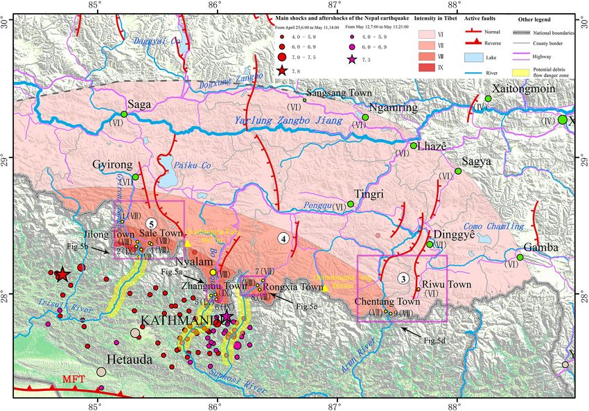
Z. Wu et al.: Damage induced by the 25 April 2015 Nepal earthquake                                                                          877

Table 2. Distribution of seismic intensity in the southern Tibet region from the Nepal earthquake.

    Intensity     Area       City, county, and town covered by seismic intensity        Damage of buildings and surfaces
                  (km2 )
    IX            105        The Zhangmu Town of Nyalam County, Jilong Town of          Most of the mud brick and stone pile build-
                             Gyirong County.                                            ings were collapsed and severely damaged, and
                                                                                        some brick houses also have obvious damage
                                                                                        and partial collapse. Collapses and landslides
                                                                                        are widespread, as well as the existence of large
                                                                                        landslides.
    VIII          1945       The Zhangmu Town and Nyalam Town of Nyalam                 Some of the mud brick and stone pile build-
                             County, Jilong Town and Sale Town of Gyirong County,       ings were collapsed or severely damaged, but
                             Rongxia Town of Tingri County.                             the buildings of brick structure are mainly mod-
                                                                                        erately to slightly damaged and there are more
                                                                                        wall cracks. Medium and small collapses and
                                                                                        landslides are common but are rarely large.
    VII           9590       Gyirong County, Nyalam County, Tingri County and           A few of the mud brick and stone pile build-
                             Dinggye County.                                            ings were severely damaged, but most build-
                                                                                        ings are slightly damaged only. There are some
                                                                                        small collapses, landslides, and rockfalls along
                                                                                        the slope of valley and highway roadcuts.
    VI            35 460     Zhongba County, Saga County, Gyirong County,               Only a few mud brick and stone pile buildings
                             Nyalam County, Tingri County and Dinggye County,           were slightly damaged, and collapses and land-
                             Gamba County, Sàgya County, Ngamring County and            slides are rare. A small amount of rockfall may
                             Lhazê.                                                     appear near the highway roadcuts.
    Felt area     300 000    Lhasa, Xigazê, Burang, Gar, and Nêdong, etc.

Town Primary School (Fig. 4e). The inhabitants of this area              sity VIII, small collapses and landslides were common, but
had to be quickly moved to temporary settlements (Fig. 4b).              large landslides were rare; intensity VII areas contain some
Perhaps some poorer buildings weakened by the first earth-               small landslides, collapses, and rockfalls along valley slopes
quake were collapsed by the second one, or the newer build-              and roadcuts, whereas in the area of intensity VI small col-
ings had more seismic resistance than realized. Some unde-               lapses and landslides are rare and a small amount of rockfalls
tected ground slippage at a few locations throughout the re-             occurred near roadcuts.
gion also may have augmented the effects to a slight degree.                This damage has the following characteristics:
   The E–W elongation of the intensity pattern (Fig. 2, Ta-
                                                                           1. They are all disrupted slides, as classified by
bles 1, 2) shows at least twice the rate of attenuation north-
                                                                              Varnes (1978; updated by Hungr et al., 2014), with a
ward towards the Himalaya Mountains than in an E or W
                                                                              loss of internal cohesion.
direction. This can be attributed to the absorption of the seis-
mic energy by the E–W-trending fault structure and litho-                  2. They occur most densely along four incised river val-
logic units of the great Himalaya Mountain block, plus a con-                 leys, which are controlled by N–S-trending rifts that
tribution from the E–W spread of the earthquakes and after-                   pass through the Himalaya Mountains and enter into
shocks.                                                                       Nepal (Fig. 2). The four valleys, successively from west
   The geologic effects caused by the Nepal earthquake are                    to east, are the Gyirong Zangbo valley that follows the
mainly landslides, terrace and loose material collapses, and                  Gyirong graben and extends southwards (Figs. 5b and
debris flows, rockfalls, and ground fissures that were stud-                  6e), the Boqu River valley that follows the Nyalam
ied in detail at 33 sites in four towns in Nyalam, Gyirong,                   graben and passes through Zhangmu and connects to
Tingri, and Dinggye counties (Figs. 2, 6). These vary with                    the Sunkoxi River valley in Nepal (Figs. 5a and 6a), the
the intensity, amount of rock weakened by previous move-                      Rongxiaqu valley that follows the southwest side of the
ment, steepness of slope, and lithology. These landslips di-                  Kong Co-Gangga graben to pass through Rongxia and
minish in number and size northward from the Nepalese bor-                    descend to the Sunkoxi River valley in Nepal (Fig. 5c),
der with the decrease in intensity. In the areas approaching                  and the Pengqu River valley, controlled by the Paiku Co
intensity IX, landslides and collapses are widespread and in-                 rift, that crosses the Kung Co-Gangga graben and the
clude some large landslides; in the areas encompassing inten-                 Pengqu graben southwards and passes through Chen-

www.nat-hazards-earth-syst-sci.net/19/873/2019/                                    Nat. Hazards Earth Syst. Sci., 19, 873–888, 2019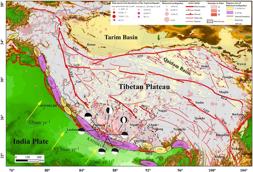
878 Z. Wu et al.: Damage induced by the 25 April 2015 Nepal earthquake
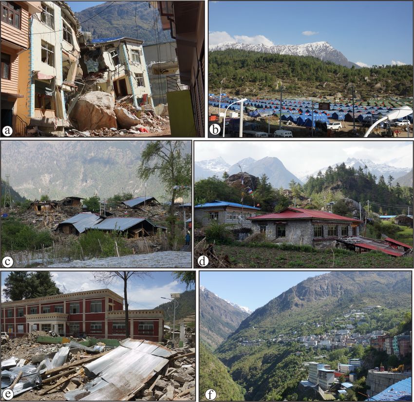
Figure 3. Building damage resulting from different earthquake intensities. (a) Many of the old stone pile or mud brick houses collapsed, but
the new brick houses rarely collapsed at Gangba Village in Sale Town in the intensity VIII zone. (b) Similar building damage at Zhuobude
Village of Rongxia Town in the intensity VIII zone. (c) Most buildings with a brick or concrete structure did not collapse, but many walls
showed obvious damage at Nyalam City located in the intensity VIII zone. (d) Some walls of the stone pile or mud brick houses collapsed
at Rema Village, Jilong County, in the intensity VII zone. (e) Similar building damage at Chentang Town, Dinggyê County, in the intensity
VII zone. (f) Most of the houses remain intact, and only few or individual walls of buildings had apparent small cracks in Gyirong City in
the intensity VI zone.
tang to connect to the Arun River in Nepal (Fig. 5d). 3. Damage often occurs in weak, soft geologic mate-
The topographic relief in these valleys is generally rial and unstable geomorphic positions: joint or fault-
about 2000–3000 m, which is very conducive to vari- formed, high, steep bedrock cliffs and slopes (Fig. 6b
ous landslips during seismic events. Furthermore, there and e); high, steep slopes of loose Quaternary sedi-
is an overall tendency for the number and size of col- ment forming river terraces, proluvial fans, and benches
lapses, landslides, and rockfalls to increase towards (Fig. 6d and f); and unstable slopes and highway road-
Nepal along these valleys. Remotely sensed images is- cuts (Fig. 6g and h). These landslides mostly occur on
sued by Google Earth after the earthquake show that the slopes steeper than 35–45◦ .
Gyirong Zangbo and the Buqu River valleys were af-
fected by the maximum density and scale of collapses 4. Most large ground fissures are associated with col-
and landslides (Figs. 5a, b, and 6a–h). lapses and landslides. They either occur on the dis-
placed masses or around their edges, and only a few
Moreover, some dammed lakes due to the collapsed such fissures occur on the surface of loose sediments
rock and soil can be seen in these valleys of Nepal. (Fig. 8).
For example, in the Gyirong Zangbo valley, a 0.07 km2
dammed lake and a 0.04 km2 dammed lake occur about These rock and soil slips caused the most serious casual-
2.5 km north of and about 7.3 km southwest of Dhunche ties and damage. The worst collapse found occurred in Disi-
Village, respectively, and in the Boqu River valley, a gang Village about 0.8 km southwest of Zhangmu, where
0.24 km2 dammed lake occurs on the north side of Dabi about 0.016 km3 of debris destroyed four or five buildings
Village. and killed seven people (Figs. 4a, 6b, and 6c). The largest
landslide found occurred about 1.3 km southwest of Chongse
Village near Jilong, where about 2 700 000 m3 of material
Nat. Hazards Earth Syst. Sci., 19, 873–888, 2019 www.nat-hazards-earth-syst-sci.net/19/873/2019/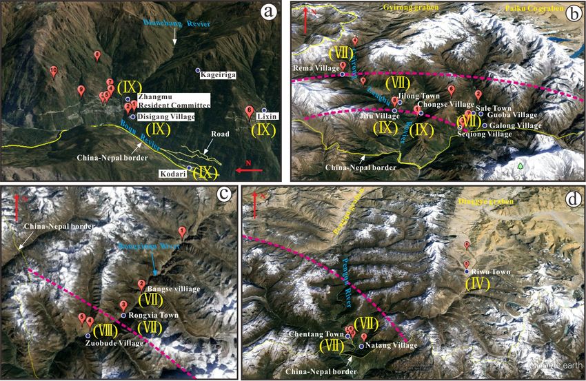
Z. Wu et al.: Damage induced by the 25 April 2015 Nepal earthquake 879
Figure 4. Typical earthquake damage in southern Tibet and comparison of houses of different construction (locations shown in Fig. 5).
(a) Huge rockfall that smashed the resident committee office building at Disigang Village, about 0.7 km south of Zhangmu, where seven
persons were killed (intensity IX) (site 1, Fig. 5a). (b) A temporary settlement for earthquake survivors at Jilong. (c) Destroyed houses of
stone block masonry or adobe construction in Jifu Village southwest of Jilong (intensity VIII) (site 8, Fig. 5b). (d) Houses of cement-bonded
stone or brick construction in Jifu Village (intensity IX). (e) Destroyed old houses and new buildings that are still standing at Sale Town
Primary School (intensity VIII) (site 7, Fig. 5b). (f) Few collapsed houses at Zhangmu due to the brick structure or reinforced concrete
construction (intensity IX).
blocked the main highway from Jilong to Gyirong Port The collapses and landslides commonly result from reacti-
(Fig. 6e). In addition, 27 small landslides and collapses oc- vation of older ones, and similar effects produced by historic
curred along the 14 km length of highway stretching from earthquakes occurred near the same position as in this earth-
this landslide to Gyirong Port. quake. Such features are notable on both banks of the Boqu
River near Zhangmu (Fig. 7a and b). At Disigang Village of
4.2 Recurrence of seismo-geological hazards Zhangmu, for example, a house built on the side of a large
rock brought down previously was destroyed by a new large
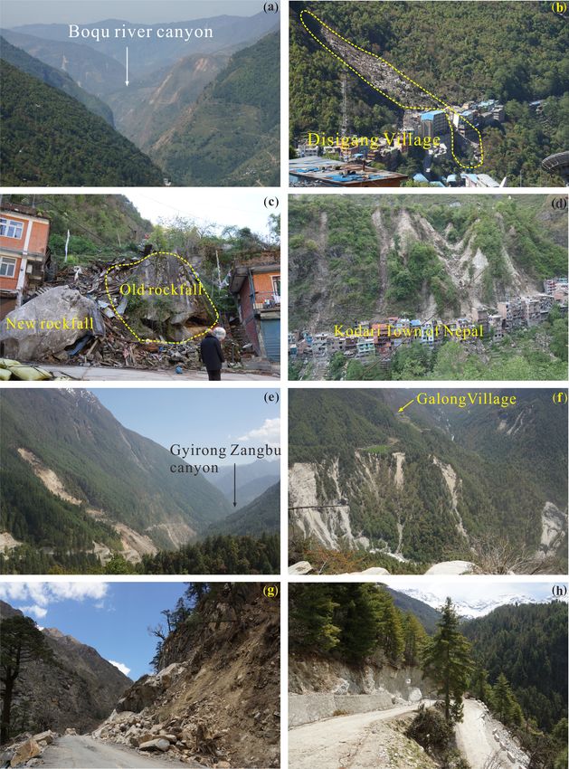
An important discovery was that the earthquake-induced rockfall (Fig. 6c). This is a warning that reconstruction after
landslide and collapse generally occurred where previous the earthquake not only should avoid potential new hazards
ones had taken place and correlated in size with the previ- as far as possible but at the same time should be aware of
ous ones. This apparently reflects the effects of ancient earth- previous ones and make a comprehensive assessment of their
quakes and provides new evidence for paleoseismicity, both stability.
in location and size. More significantly, this demonstrates The specific structural damage is usually related to the ma-
that the areas of ancient landslide and collapse indicate the terial and type of building construction in these areas; the
potential areas of danger from further landslips from torren- heaviest destruction occurred near the Nepal border. In this
tial rains and future earthquakes, important considerations in region with few trees, most of the houses are of simple stone
seismic risk evaluation and the post-earthquake reconstruc- and adobe construction, and these fared poorly during the
tion process. earthquake, with the majority being destroyed near the Nepal
www.nat-hazards-earth-syst-sci.net/19/873/2019/ Nat. Hazards Earth Syst. Sci., 19, 873–888, 2019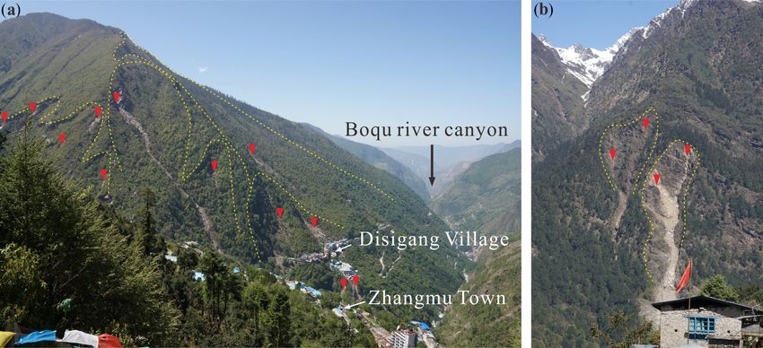
880                                                       Z. Wu et al.: Damage induced by the 25 April 2015 Nepal earthquake

Figure 5. Main surveyed sites of seismic effects after the Nepal earthquake; see Fig. 2 for the locations (image source Google Earth). Roman
numerals in brackets denote seismic intensity values of the corresponding location. Pink dotted lines show the boundaries between different
intensity zones. (a) Zhangmu Town and vicinity. (b) Jilong Town and environs. (c) Rongxia Town and vicinity. (d) Riwu Town to Chentang
Town. Numbered balloons denote sites which experienced significant effects. Red dashed lines show the isoseismal boundaries.

border (Figs. 3b, d, e, 4c). Houses with cement-bonded stone            et al., 2011; Saba et al., 2010; Tang et al., 2011; Dadson
or brick construction survived much better (Figs. 3a, 4d), and          et al., 2004). Rain may even be a factor during an earth-
those of good brick or reinforced concrete construction suf-            quake. Data in New Zealand suggest that earthquakes that oc-
fered the least (Figs. 3c, 4f) and provided a contrast with             cur during wetter months trigger more landslides than those
those of poorer materials (Figs. 3a, 4e).                               during drier periods, although a clear relationship between
                                                                        rainfall-induced pore pressure and earthquake-induced land-
4.3   Post-seismic increased potential geological hazard                slide triggering has not been shown (Dellow and Hancox,
                                                                        2006; Parker et al., 2015). When Typhoon Toraji hit Taiwan
The Nepal earthquake has left many potential dangers in its             following the 2005 Mw 7.6 Chi-Chi earthquake, 30 000 more
wake in this region, and nearby seismically active areas in             landslides occurred, with many being reactivated ones trig-
southern Tibet that do not fit on an intensity scale yet are            gered by the earthquake, although 80 % of the Toraji land-
a consequence of the earthquake and pose a serious hazard               slides occurred in areas that had not failed during the earth-
that might create even greater damage and casualties than               quake (Dadson et al., 2004). The proportion of surface area
the immediate effects. The delayed effects in southern Tibet            disturbed by the landslides increased towards the active fault,
are the consequences of earthquake-loosened landslides and              suggesting that even in areas that underwent no landslips dur-
weakened rock that may fall due to aftershocks and torrential           ing the earthquake, the substrate was preconditioned to fail
storms and from secondary earthquakes due to changes in the             through loss of cohesion and frictional strength of hill slope
stress field resulting from the Nepal earthquake.                       rock mass caused by the strong seismic motion (Dadson et
   Rock, terrace material, and previous landslides loosened             al., 2004).
by the earthquake but still in place may fail with small after-            A similar general weakening of rock strength was deduced
shocks and torrential rains, which further weaken the mate-             in the mountainous region of South Island, New Zealand,
rial and add weight. Such an increase in secondary landslips            where to test the possible influence of previous earthquakes
during rainy seasons following earthquakes has been noted               in preconditioning the ground for landsliding, the areas of
previously and is becoming a recognized hazard. Increased               overlap of high intensity of similarly strong, > Mw 7, 1929
rainfall-triggered landslide activity above normal rates has            and 1968 earthquakes were compared (Parker et al., 2015).
been observed after several large earthquakes, two of which             Many landslides produced in 1968 were reactivations or en-
occurred in similar terrane to the east and west (Hovius

Nat. Hazards Earth Syst. Sci., 19, 873–888, 2019                                  www.nat-hazards-earth-syst-sci.net/19/873/2019/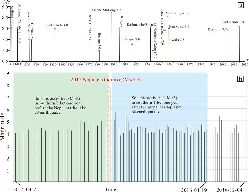
Z. Wu et al.: Damage induced by the 25 April 2015 Nepal earthquake                                                                          881

Figure 6. Geologic effects caused during the Nepal earthquake: (a) collapses in the Boqu valley; (b) collapse at Disigang Village in the Boqu
valley (site 1, Fig. 5a); (c) new and old rockfalls at Disigang Village in the Boqu valley (site 1, Fig. 5a); (d) destroyed buildings in Kodari,
Nepal, in the Boqu valley (site 1, Fig. 5a); (e) large landslide in Chongse Village in the Gyirong Zangbo valley (site 1, Fig. 5b); (f) collapses
in Galong Village in the Gyirong Zangbo valley (site 7, Fig. 5b); (g) collapses along the highway from Gyirong County to Jilong Town in
the Gyirong Zangbo valley (site 4, Fig. 5b); and (h) collapses and fissures along the highway from Jilong to Chongse Village in the Gyirong
Zangbo valley (site 1, Fig. 5b).

largements of ones that failed in 1929, but others were not,               that the damage legacy of large earthquakes may persist in
although there was a higher degree of failure in the over-                 parts of the landscape for much longer than the observed less
lapped area than could be easily explained in considering all              than 10-year periods of post-seismic landslide activity and
the factors normally involved in landslip. These observations              sediment evacuation.
suggested that hill slopes may retain damage from past earth-                 Similarly, data from the 2010 Mw 7.1 Canterbury–2011
quakes, which makes them more susceptible to failure in fu-                Ms 6.3 Christchurch earthquake sequence reveal landslide
ture triggering events, and this influenced the behavior of the            triggering at lower ground accelerations following the Febru-
landscape in the 1968 earthquake. It was further suggested                 ary 2011 earthquake, which caused cracks to develop in hill

www.nat-hazards-earth-syst-sci.net/19/873/2019/                                       Nat. Hazards Earth Syst. Sci., 19, 873–888, 2019
882                                                   Z. Wu et al.: Damage induced by the 25 April 2015 Nepal earthquake

slopes that subsequently failed in later earthquakes in the se-      Unstable masses found to date are the reactivated landslide
quence (Massey et al., 2014a, b; Parker et al., 2015).            group at Zhangmu, collapse of the upper edge of the Sale
   This general loosening of rock through ground motion also      Village landslide in Sale, potential failure of the dangerous
occurred at the Nevada test site, where deep underground          rock mass at Rongxia Primary School, and instability of the
nuclear explosions, similar to shallow earthquakes, caused        old Natang Village landslide and its upper edge at Chentang
widespread movement along joints within the overlying             Town.
bedrock. Some fractures were propagated upward through               All of Zhangmu is located on a group of old landslides
610 m of alluvium to demonstrate how even this soft material      (Figs. 4a, 7a, and 7b). Discontinuous tension fissures, which
was weakened further.                                             are tens to hundreds of meters long, about 10 cm wide and
   The progressive brittle damage accumulation in hill slope      2 to 4 m deep, were found at its upper edge and on its sides
materials may lead to permanent slope displacement that re-       after the earthquake (Fig. 8a and b). These fissures indicate
sults in cracking and dilation of the mass, which makes them      the possibility of the failure of the entire landslide group.
more susceptible to failure (Petley et al., 2005; Nara et al.,       The Sale Village landslide resulted from the earthquake
2011; Bagde and Petroš, 2009; Li et al., 1992; Parker et al.,     on the slope along the highway from Sale Village to Seqiong
2015). Whether or not a hill slope fails in response to an        Village (Fig. 5b). It was nearly 600 000 m3 in volume and its
earthquake thus becomes a function of both a current event        fall blocked the road. Large tension fissures at its upper edge
and the history of damage accumulated from previous events        indicate a danger of further slippage (Fig. 8c).
(Parker et al., 2015).                                               The dangerous rock mass at Rongxia Village Primary
   These later landslides pose all of the same dangers as those   School occupies a convex portion of the cliff behind the
occurring during the initial earthquake and also may cause        school and appears unstable (Figs. 5c and 8d). A rockfall
damming of rivers to create dangerous reservoirs that can fail    occurred here during the earthquake, but the fall appears to
with devastating effects.                                         have been incomplete and left a cliff that lacks stability and
   The landslips also increase the hazard from flooding in the    is susceptible to further rockfall.
disturbed region. They contribute debris to valleys to widen         Natang Village near Chentang is located at the front, lower
them and raise river beds, which greatly raises the flood dan-    edge of an old landslide, which is about 420 m long and
ger as has happened in the region of the Wenchuan earth-          230 m wide and consists of an area of about 1 200 000 m3
quake since 2008 (Yang et al., 2015). This is a problem that      (Figs. 5d and 8e). The steep wall at its upper edge appears as
needs to be recognized in post-earthquake reconstruction.         two large dangerous rock blocks which are about 60 000 m3
   Such consequences from earthquakes are long-lasting. It is     in volume, and a 1.7 m wide preexisting crack occurred be-
estimated to have taken 3 years for the Kashmir earthquake        tween the unstable rock blocks and the bedrock (Fig. 8f).
region to recover, 6 for the Chi-chi earthquake, over 7 for the   The earthquake caused a partial rockfall and demonstrates
Wenchuan earthquake and even longer for others (Saba et al.,      the dangerous instability of the mass that might fall easily.
2010; Yang et al., 2015; Dadson et al., 2004).                       The danger of post-seismic debris flows also must be
   There is a worry of additional landslides and rockfalls af-    stressed; although these were rare for this earthquake in the
ter the Nepal earthquake, especially of large ones, that might    southern Tibet region, they were a serious problem after the
block river valleys and impound water. Indeed, both the num-      Wenchuan earthquake (Cui et al., 2010; Tang et al., 2011).
ber and range of collapse and rockfall have clearly increased     There is, however, a considerable amount of loose debris ac-
in the year’s rainy season following the earthquake. (Cheng-      cumulated in mountain valleys and gullies that could pro-
can Zhou, personal communication, 2015) noted that be-            vide material for further debris flows, especially on the south
fore the earthquake, collapses and rockfalls only occurred        slope of the Himalaya Mountains. Rainfall, which provides
on steep hill slopes on both sides of the Boqu River north        excessive water to lubricate land slips and adds weight to
of Zhangmu Town, but now they take place along the en-            a loose mass, is a key factor in inducing post-seismic debris
tire highway in this area. He reports that the increased haz-     flows as well as triggering landslides and rockfalls. There is a
ard has caused many road closures and damaged vehicles but        large difference in rainfall between the south and north slopes
no casualties as yet because the town was evacuated after         of the Himalaya Mountains. The annual average rainfall at
the earthquake. The increased hazards are mainly distributed      Zhangmu on the south slope is up to 2556.4 mm a−1 , whereas
nearby along the highway between Nyalam to Zhangmu                the annual average rainfall in Jilong and the seat of Nyalam
where 18 major landslide groups were identified after the         County on the north slope is only 880.3 and 654.0 mm a−1 ,
earthquake by the National Disaster Reduction Center of the       respectively. The rainfall on the south slope was concentrated
Ministry of Civil Affairs using high-resolution remote sens-      in the Indian Ocean summer monsoon season, and induced
ing images. Such an increase in the number of slides should       debris flows were already being reported in Nepal at the be-
be widespread in several major valleys of southern Tibet, but     ginning of June. The several incised valleys in the south men-
relatively few have been reported due to scarce personnel and     tioned above are sites of potentially dangerous post-seismic
poor transportation and communication.                            debris flows in Tibet, particularly in the three deeply incised
                                                                  valleys leading toward Nepal that have a high potential for

Nat. Hazards Earth Syst. Sci., 19, 873–888, 2019                           www.nat-hazards-earth-syst-sci.net/19/873/2019/
Z. Wu et al.: Damage induced by the 25 April 2015 Nepal earthquake 883
Figure 7. New and old collapses and landslides on both banks of the Boqu River in Zhangmu Town: (a) the east bank and (b) the west
bank. The yellow dotted lines show the boundaries of old collapses and landslides. The red triangles denote new collapses during the Nepal
earthquake.
flows that could dam the rivers to form dangerous lakes. The numerous landslides, collapses, and rockfalls oc-
These valleys, from west to east, are the Gyirong Zangbo curred on slopes steeper than 35–45◦ and usually at locations
River in the upper basin of the Trisuli River, the Boqu River, where previous ones took place. This seems to reflect the ef-
and the Rongxiaqu River in the upper basin of the Sunkoxi fects of ancient earthquakes and provides new evidence for
River (Fig. 2). Another danger spot is in the Dianchang gul- paleoseismicity. The presence of large landslides, which ei-
ley on the south side of Zhangmu (Figs. 5a and 7a), where ther did not fail or only partially so, also suggests that larger
considerable loose debris is in a very unstable state. earthquakes affected this region in the past. These sites of
ancient and modern slips mark the hazardous areas in future
earthquakes, an important consideration in seismic risk eval-
5 Discussion uation and the post-earthquake reconstruction process.
The Nepal earthquake both changed and brought out fea-
5.1 Pattern of damage
tures that enhance the seismic hazard in the near and long
The Nepal earthquake was felt over a wide region of south- term. The principal geologic dangers emanate from land-
ern Tibet. Fortunately, few casualties occurred because of the slides, collapses, and rockfalls in this steep terrane from ones
sparse population, but there was extensive damage due to the loosened or which only partially failed immediately or new
presence of many poorly built stone and adobe buildings and ones from ground weakened by the general ground shaking
the impact of landslides, collapses, and rockfalls in this steep of the earthquake. These will be more common in the next 3
mountainous region of high relief that is similar to the Nepal to 6 years or so as a delayed effect of the earthquake, espe-
region (Zekkos et al., 2017); the intensity near the Nepal bor- cially in seasons of heavy rainfall. All of the areas of older
der approached IX. The intensity distribution showed that the landslips, whether or not they reactivated in this earthquake,
attenuation rate northward was more than twice that in either are susceptible to reactivation and are particularly dangerous.
eastward or westward directions due to the absorption of en- In recent years it has been discovered that ground motion
ergy by the major E–W-trending structure of the region and from large earthquakes results in weakened cohesiveness of
the trend of the seismic activity in the epicentral area. The the ground and causes more abundant landslips subsequently.
intensity survey demonstrated a very wide difference in seis- These may clog valleys to form dangerous reservoirs. Such
mic performance between these poorly built buildings and an increase in landslips has already been noted in the study
well-built brick and concrete ones. In addition to the imme- area this past summer.
diate damage shown by the intensity, there are the delayed Both the landslips during an earthquake and the delayed
effects of further dangerous land movement and an increased ones contribute debris to the river valleys which widens them
potential for a significant earthquake over the next several and raises riverbeds to create conditions which are conducive
years, all of which are important in consideration of the seis- to flooding.
mic hazard in the region and post-earthquake reconstruction. This can destroy additional buildings and endanger
bridges as in the area of the Wenchuan earthquake (Yang et
al., 2015).
www.nat-hazards-earth-syst-sci.net/19/873/2019/ Nat. Hazards Earth Syst. Sci., 19, 873–888, 2019884 Z. Wu et al.: Damage induced by the 25 April 2015 Nepal earthquake
Figure 8. Fissured and unstable rock masses formed by the earthquake that indicate hazards for additional landslides and rockfalls. The
yellow dotted lines show the landslide group. Arrows denote the slip direction, and the red line denotes new fissures formed during the Nepal
earthquake. (a) Old landslide group at Zhangmu. (b) New fissure in the old landslide group at Zhangmu (Fig. 8a). (c) Tension fissures at the
back edge of Sale Village landslide (site 7, Fig. 5b). (d) Dangerous rock mass at Rongxia Primary School (site 3, Fig. 5c). (e) Old landslide
with unstable rock at Chentang Town (site 1, Fig. 5d) . (f) Fissure between unstable rock and bedrock at Chentang (Fig. 8e).
Following these characteristics, we should focus on three 5.2 Relationship between the MHT and N-trending
circumstances in the assessment of seismic geological haz- rifts
ards (mainly referring to collapse, landslips, and rockfall
here) within areas that are affected by many strong earth-
quakes and high relief:
The Nepal earthquake has likely set the stage for another
1. steep slopes formed by loose bodies, such as thick allu- forceful nearby earthquake that can be considered a delayed
vial and residual deposits, in deep valleys; effect. The release of energy in a great earthquake such as
the Nepal earthquake may shift the strain to the adjacent
2. places with multiple periods of landslides, collapses, regions where other earthquakes may then occur, such as
and rockfalls; the strong earthquakes that occurred in Tibet following the
3. the revived possibility of known landslides and col- Ms 8.0 Wenchuan earthquake (Wu et al, 2011). The seismic
lapses in future earthquakes. history of the southern border of Tibet appears to bear this
out. Large earthquakes along the south margin on the Main
Frontal Thrust of the Main Himalayan Thrust are followed
by ones along the N–S-trending normal faults in the region
to the north (Fig. 1). There now is an increased concern that
Nat. Hazards Earth Syst. Sci., 19, 873–888, 2019 www.nat-hazards-earth-syst-sci.net/19/873/2019/Z. Wu et al.: Damage induced by the 25 April 2015 Nepal earthquake 885 a significant earthquake may occur along the normal faults in nearly N–S-trending normal faulting-type earthquakes: the the region based on this recent history. former occurred in the Nyalam–Coqên rift and the latter at Southern Tibet is an earthquake-prone region with long E– the southern end of the Xainza–Dinggye rift. However, these W-trending active thrust faults such as that which caused the movements are unlikely to have released all the built up ex- Nepal earthquake; less well known are the important active tensional force. Recently, Elliott et al. (2010) found from the normal faults and grabens just to the north (Figs. 1 and 2). InSAR and body wave seismological images of normal fault- These normal faults form at least eight nearly N–S-trending ing earthquakes that the extension rate due to the contribution rifts across southern Tibet. Geological estimates and GPS of the seismic energy released through normal faulting for data show that the E–W extension rates across the rifts were the past 43 years in the southern Tibet region is 3–4 mm a−1 , 10–13 mm a−1 during the Quaternary and Holocene (Armijo which is only equivalent to 15 %–20 % of the extension rate et al., 1986; Chen et al., 2004). Such rates are close to the obtained by GPS measurements. This suggests that there still Holocene slip rate of 21±1.5 mm a−1 along the Main Frontal is about 80 % of the energy due to extension to be released, Thrust of the Main Himalaya Thrust (Lavé and Avouac, possibly as near-future seismic activity. 2000) and to the recent GPS-based shortening rate of 10– The extension also may affect a set of NW-trending right- 19 mm a−1 across the Himalaya orogenic belt (Larson et al., lateral strike-slip fault zones that have significant activity in 1999; Jouanne et al., 1999; Zhang et al., 2004; Bettinelli et the southern Tibet region. These are, from west to east, the al., 2006). There thus appears to be a close kinematic con- Karakorum fault zone, the Gyaring Co fault zone, and the nection between the thrusting on the Main Himalaya Thrust Beng Co fault zone (Fig. 1). Their Quaternary strike-slip rate and the nearly N–S-trending normal faulting in the southern may reach 10–20 mm a−1 (Armijo et al., 1989; Chevalier et Tibet region as indicated by the historic seismicity (Armijo al., 2005). Such faults with high strike-slip rates also can play et al, 1989; Molnar and Lyon-Caen, 1989). an important role in adjusting the nearly E–W extensional Often within a short time interval of about 1 to 10 years deformation in the area. For example, a M 8.0 earthquake after great earthquakes on the Main Himalaya Thrust, strong in southwestern Nagqu in 1951, which occurred along the earthquakes occur on the N–S-trending normal faults in the NW-trending Beng Co fault zone, followed the 1950 M 8.6 southern Tibet region (Fig. 1, 9a). For example, the great Zayü earthquake of eastern Tibet that is known in India as Kashmir earthquake of 1400 was followed by a M 8.0 earth- the Assam earthquake. quake in the Damxung–Yangbajain sector of the northern Based on past experience, the southern Tibetan region in Yadong–Gulu rift in 1411, a M 8.1 earthquake in the west- the vicinity of the Nepal earthquake is likely to have a normal ern part of Nepal in 1803 was followed by a M 7.5 earth- fault earthquake within the next 10 years. quake in the southern sector of the Cona–Oiga rift in 1806, and the M 7.8 Kashmir earthquake of 1905 was followed 5.3 Suggestions for regional earthquake prevention by a M 7.5 earthquake at Sangri in the northern sector of and disaster mitigation the Cona–Oiga rift in 1915. Similarly, after the M 8.1 1934 Nepal earthquake, a M 7.0 earthquake in the same year oc- This investigation is preliminary and generalized, but tenta- curred in the N–S-trending Gomang Co graben in northeast- tive recommendations can be issued to guide reconstruction ern Xainza County, and after the 1950 M 8.6 China–Indian in the region. border earthquake, a M 7.5 earthquake occurred in 1952 in First, southern Tibet is a region with remarkable historical the northern sector of the Yadong–Gulu rift in Nagqu County. seismicity where earthquakes and their effects cannot effec- Another delayed effect of the earthquake is the enhanced tively be forecast, but a reevaluation of the earthquake haz- seismic hazard due to the release in energy and the shift in ards should be made as soon as possible to indicate the po- strain, based on the past seismic history. The Nepal earth- tential dangers noted in this survey. quake emphasizes the close relation between the seismic ac- Second, the relocation and reconstruction of damaged res- tivity and the dynamics in the nearly east–west stretch of de- idential areas need to consider the potential dangers of post- formation along the Himalaya foothills and the controlling seismic hazards and stability of previous seismically induced activity along the Main Himalaya Thrust, which triggered the geologic effects. Areas of ancient landslides, collapse, and Nepal earthquake. Extensional forces that are about perpen- rockfall, in particular, need to be mapped and avoided, es- dicular to the active thrust have a history of resulting in a pecially for schools, hospital, utilities, and vital government nearby significant normal fault earthquake following thrust buildings and, where possible, roads and bridges. Bridges movement within the subsequent 10 years that results in fur- might be rebuilt higher in valleys where riverbeds may be ther destruction and fatalities. Some normal fault activity has raised and the flood danger enhanced due to increased debris indeed been noted in the aftershocks of the Nepal earthquake flow from the displaced material. And for the same reason, but not nearly enough to release the expected strain (Fig. 9b). selection of building sites in valleys must be chosen with On the first and second day after the 2015 Nepal earth- care. A wide selection for new, safer sites for construction quake a Mw 5.4 earthquake occurred in Nyalam County and should be provided in the vast southern Tibetan region with a Ms 5.9 earthquake in Tingri County, respectively. Both are its very low population density. www.nat-hazards-earth-syst-sci.net/19/873/2019/ Nat. Hazards Earth Syst. Sci., 19, 873–888, 2019
886                                                       Z. Wu et al.: Damage induced by the 25 April 2015 Nepal earthquake

Figure 9. (a) Magnitude–time (Ms –T ) distribution of historical seismic activity along Himalaya and southern Tibet with the magnitude > 7.0.
The orange circles show the earthquakes that occurred along Himalaya, while the green circles show the earthquakes along the southern
Tibetan rift. (b) Magnitude–time (M–T ) distribution of seismic activity in southern Tibet in the period of 1 year before and after the 2015
Nepal earthquake (data are from USGS).

   Third, in the repair and reconstruction of buildings, new                  veloped in the N-trending rifts in southern Tibet. How-
anti-seismic construction codes must be adopted. The re-                      ever, the damage was not related to the faulting of N-
placement of poorly built stone and adobe building by more                    trending rifts.
seismic resistant brick and concrete ones should be given a
high priority.                                                             2. The earthquake-induced landslides and collapses gener-
   Fourth, over the next 10 years there should be heightened                  ally occurred where previous ones had taken place and
awareness and preparations for a possible earthquake in one                   were correlated in size with the previous ones. There-
of the grabens of southern Tibet.                                             fore, the areas of ancient landslide and collapse indicate
   Finally, although more detailed seismic-geological study                   the potential areas of danger from further landslips from
is, of course, necessary, greater urgency should be directed at               torrential rains and future earthquakes.
the construction of better anti-seismic buildings and facilities           3. The directional features, paleo-earthquakes, and defor-
in areas away from potential geological hazards that may be                   mational rate of damage also suggest that the E–W ex-
triggered by earthquakes.                                                     tensional deformation in southern Tibet is closely as-
                                                                              sociated with the Himalaya thrust fault. Then, the ac-
                                                                              tivity of the MHT could trigger the active faulting of
6    Conclusions                                                              N-trending rifts.

    1. Damage caused by the Nepal earthquake in Tibet varies
       with the intensity, amount of rock weakened by previ-             Data availability. Most of the data are made available in tables and
       ous movement, steepness of slope, and lithology. And              the Supplement of this paper (note that there are no data beyond
       the damage shows that directional features mainly de-             articles and supplements).

Nat. Hazards Earth Syst. Sci., 19, 873–888, 2019                                   www.nat-hazards-earth-syst-sci.net/19/873/2019/
Z. Wu et al.: Damage induced by the 25 April 2015 Nepal earthquake 887
Supplement. The supplement related to this article is available Chen, Q. Z., Freymueller, J. T., Yang, Z. Q., Xu, C. J., Jiang, W.
online at: https://doi.org/10.5194/nhess-19-873-2019-supplement. P., Wang, Q., and Liu, J. N.: Spatially variable extension in
southern Tibet based on GPS, J. Geophys. Res., 109, B09401,
https://doi.org/10.1029/2002JB002350, 2004.
Author contributions. ZW and PJB conceived and prepared the en- Chevalier, M. L., Ryerson, F. J., Tapponnier, P., Finkel, R. C., Jermo,
tire paper, GH collated and analyzed the earthquake data related V. D. W., Li, H. B., and Liu, Q.: Slip-Rate measurements on the
to the nearly N-S trending normal faulting in southern Tibet, XY Karakorum fault may imply secular variations in fault Motion,
and YX participated in the field survey and provided some data of Science, 307, 411–414, 2005.
earthquake-induced geo-hazards, and JL collated seismic data from China Earthquake Administration, GB/T 17742-2008: The Chinese
the Himalayan belt and seismic intensity data from southern Tibet. seismic intensity scale, issued by the General Administration of
Quality Supervision, Inspection and Quarantine of the People’s
Republic of China & Standardization Administration of the Peo-
Competing interests. The authors declare that they have no conflict ple’s Republic of China, 2008.
of interest. China Earthquake Administration: An intensity map of Tibet for the
M 8.1 Nepal earthquake, available at: https://www.cea.gov.cn/
cea/dzpd/dzzt/369476/369477/1231101/index.html, last access:
1 May 2015.
Acknowledgements. This work was supported by the National Nat-
Cui, P., Zhuang, J. Q., Chen, X. C., Zhang, J. Q., and Zhou, X. J.:
ural Science Foundation of China (no. 41571013 and 41171009).
Characteristics and countermeasures of debris flow in Wenchuan
We would like to thank Tingshan Tian and Jietang Lu of the
area after the earthquake, J. Sichuan Univ., (Engineer. Sci. Ed.),
China Institute of Geo-environment Monitoring, Qiang Xu and
42, 10–19, 2010.
Guang Zheng of the Chengdu University of Technology, and Ji Duo
Dadson, S. J., Hovius, N., Chen, H., Dade, W. B., Lin, J. C., Hsu,
and Baoben Xia of the Geology and Mineral Resources Exploration
M. L., Lin, C. W., Horng, M. J., Chen, T. C., Milliman, J., and
Bureau of Xizang Autonomous Region for their participation of our
Stark, C. P.: Earthquake-triggered increase in sediment delivery
field investigation. We also appreciate the help extended by the De-
from an active mountain belt, Geology, 32, 733–736, 2004.
partment of Land and Resources of Xizang Autonomous Region
Dellow, G. D. and Hancox, G. T.: The influence of rainfall
and relevant local governments.
on earthquake-induced landslides in New Zealand, in: Pro-
ceed. Tech. Groups, Earthqs. and Urban Develop: New Zealand
Geotech. Soc. 2006 Sym., Nelson, New Zealand, 355–368, 2006.
Review statement. This paper was edited by Maria Ana Baptista Dewey, J., Shackleton, R. M., Chang, C., and Sun, Y.: The tectonic
and reviewed by five anonymous referees. evolution of the Tibetan Plateau, Philos. T. R. S.-A, 327, 379–
413, 1988.
Elliott, J. R., Walters, R. J., England, P. C., Jackson, J. A., Li, Z.,
and Parsons, B.: Extension on the Tibetan plateau: recent nor-
mal faulting measured by InSAR and body wave seismology,
References Geophys. J. Int., 183, 503–535, https://doi.org/10.1111/j.1365-
246X.2010.04754.x, 2010.
Armijo, R., Tapponnier, P., Mercier, L., and Han. T. L.: Quaternary Hovius, N., Meunier, P., Lin, C. W., Chen, H., Chen, Y.
extension in southern Tibet: Field observation and tectonic im- G., Dadson, S., Horng, M. J., and Lines, M.: Prolonged
plication, J. Geophys. Res., 91, 13803–13872, 1986. seismically induced erosion and the mass balance of a
Armijo, R., Tapponnier, P., and Han, T. L.: Late Cenozoic right- large earthquake, Earth Planet. Sc. Lett., 304, 347–355,
lateral strike-slip faulting in southern Tibet, J. Geophys. Res., 94, https://doi.org/10.1016/j.epsl.2011.02.005, 2011.
2787–2838, 1989. Hungr, O., Leroueil, S., and Picarelli, L.: The Varnes classifica-
Avouac, J. P.: Dynamic processes in extensional and compressional tion of landslide types, an update, Landslides, 11, 167–194,
settings – mountain building: from earthquakes to geological de- https://doi.org/10.1007/s10346-013-0436-y, 2014.
formation, Treatise on Geophys., 6, 377–439, 2007. Institute of Geophysics, China Earthq. Admin.: The M5.9 Tingri
Bagde, M. N. and Petroš, V.: Fatigue and dynamic energy behaviour earthquake of April 25 2015 in Tibet, available at: http://www.
of rock subjected to cyclical loading, Int. J. Rock. Mech. Min., cea-igp.ac.cn/tpxw/272116.shtml, last access: 10 May 2015.
46, 200–209, 2009. IRIS: Special event: Nepal, Incorp. Research Insts for Seis,
Bettinelli, P., Avouac, J. P., and Flouzat, M.: Plate motion of available at: http://ds.iris.edu/ds/nodes/dmc/specialevents/2015/
India and interseismic strain in the Nepal Himalaya from 04/25/nepal/, last access: 24 May 2015.
GPS and DORIS measurements, J. Geod., 80, 567–589, Jouanne, F., Mugnier, J. L., Pandey, M. R., Gamond, J. F., LeFort, P.,
https://doi.org/10.1007/s00190-006-0030-3, 2006. Serrurier, L., Vigny, C., Avouac, J. P., and the Idylhim members:
Bijukchhen, S., Takai, N., Shigefuji, M., Ichiyanagi, M., and Sasa- Oblique convergence in the Himalayas of western Nepal deduced
tani, T.: Strong-Motion Characteristics and Visual Damage As- from preliminary results of GPS measurements, Geophys. Res.
sessment Around Seismic Stations in Kathmandu After the 2015 Lett., 26, 1933–1936, 1999.
Gorkha, Nepal, Earthquake, Earthq. Spectra, 33, S219–S242, Larson, K., Burgmann, R., Bilham, R., and Freymueller, J. T.: Kine-
https://doi.org/10.1193/042916EQS074M, 2017. matics of the India-Eurasia collision zone from GPS measure-
Bilham, R.: Earthquakes in India and the Himalaya: tectonics, ments, J. Geophys. Res., 104, 1077–1093, 1999.
geodesy and history, Ann. Geophys., 47, 839–858, 2004.
www.nat-hazards-earth-syst-sci.net/19/873/2019/ Nat. Hazards Earth Syst. Sci., 19, 873–888, 2019You can also read