Do wildlife corridors link or extend habitat? Insights from elephant use of a Kenyan wildlife corridor - Lewa Wildlife ...
←
→
Page content transcription
If your browser does not render page correctly, please read the page content below
Received: 29 July 2017      |   Revised: 10 July 2018   |   Accepted: 11 July 2018

DOI: 10.1111/aje.12541

SPECIAL SECTION : CAMERA TRAPPING IN AFRICA

Do wildlife corridors link or extend habitat? Insights from
elephant use of a Kenyan wildlife corridor

Siân E. Green1,2                      | Zeke Davidson2 | Timothy Kaaria3 | C. Patrick Doncaster1

1
 Biological Sciences, University of
Southampton, Southampton, UK                            Abstract
2
Marwell Wildlife, Colden Common,                        Human encroachment on wildlife habitats is leading to increased fragmentation;
Winchester, UK
                                                        hence, there is an increasing focus on improving connectivity between remaining
3
    Lewa Wildlife Conservancy, Isiolo, Kenya
                                                        habitat. Large, wide‐ranging species such as the African elephant, (Loxodonta afri-
Correspondence                                          cana), are particularly vulnerable due to their extensive habitat requirements. Wild-
Siân E. Green, Beer Mill, Clawton, Devon,
EX22 6PF, UK.                                           life corridors have been created to facilitate movement, with little knowledge to
Email: sian.green92@outlook.com                         date on whether they serve their intended function as transit routes, or whether
                                                        they simply extend the available habitat for occupancy. We collected data on ele-
                                                        phant behaviour in the Mount Kenya Elephant Corridor, with the aim of quantifying
                                                        the utility of the corridor. A grid of 25 camera traps was used to survey the 478 ha
                                                        corridor over 11 weeks. Cameras recorded over 43,000 photos with 694 separate
                                                        events triggered by elephants. Patterns of use varied spatially and temporally, indi-
                                                        cating that certain areas were treated as habitat extension, while others were pre-
                                                        dominantly for transit. These differences were likely due to variation in vegetation
                                                        cover and levels of human disturbance. Corridor use differed amongst individuals,
                                                        suggesting that use may depend on both the characteristics of the corridor itself
                                                        and the social or resource needs of individual elephants.

                                                        Résumé
                                                        L'envahissement des habitats naturels par les hommes entraîne un accroissement de
                                                        la fragmentation, et l'on s'intéresse de plus en plus à l'amélioration de la connectivité
                                                        entre les habitats restants. Des espèces de grande taille, qui font de grands déplace-
                                                        ments, comme les éléphants Loxodonta africana sont particulièrement vulnérables
                                                        parce qu'elles ont besoin de grands espaces. Des corridors ont donc été créés pour
                                                        faciliter les déplacements, sans que l'on sache bien, jusqu’à présent, s'ils remplissent
                                                        bien leur fonction de voies de transit ou s'ils agrandissent simplement l'habitat dis-
                                                        ponible. Nous avons récolté des données sur le comportement des éléphants dans
                                                        le Corridor des éléphants du mont Kenya, afin de quantifier l'utilité de ce corridor.
                                                        Un réseau de 25 pièges photographiques a permis de surveiller les 478 ha de ce
                                                        corridor pendant 11 semaines. Les appareils ont enregistré plus de 43,000 photos et
                                                        694 événements différents ont été déclenchés par des éléphants. Les schémas d'uti-
                                                        lisation variaient dans l'espace et le temps, ce qui veut dire que certains endroits
                                                        étaient considérés comme une extension de l'habitat alors que d'autres servaient
                                                        surtout au passage. Ces différences étaient probablement dues à des variations du
                                                        couvert végétal et au niveau de perturbations humaines. La fréquentation du

860     |   © 2018 John Wiley & Sons Ltd                            wileyonlinelibrary.com/journal/aje                    Afr J Ecol. 2018;56:860–871.
GREEN   ET AL.                                                                                                                               |   861

                                                 corridor différait selon les individus, ce qui suggère que l'utilisation peut dépendre
                                                 des caractéristiques du corridor lui‐même et des besoins sociaux ou de ressources
                                                 de chaque individu.

                                                 KEYWORDS
                                                 African elephants, camera trapping, connectivity, corridor

1 | INTRODUCTION                                                             Omondi, Kock, & Amin, 2012; Ngene et al., 2013). This expansion is
                                                                             hindered by a growing human population. Elephants are sensitive to
Current species extinction rates far exceed the natural background           anthropogenic disturbance, making them susceptible to human activity
rate (Ceballos et al., 2015), with a major driver for this being habitat     blocking traditional routes (Epps, Wasser, Keim, Mutayoba, & Bra-
loss. Habitat loss can be further compounded by isolation and frag-          shares, 2013; Graham, Douglas‐Hamilton, Adams, & Lee, 2009; Kioko
mentation of remaining habitat (Crooks, Burdett, Theobald, Ron-              et al., 2015). Where humans and elephants do interact, it can lead to
dinini, & Boitani, 2011) and simply protecting habitat is not proving        conflicts such as crop raiding and retaliatory killings (Gadd, 2005;
adequate to cope with ongoing biodiversity loss (Mora & Sale,                Mackenzie & Ahabyona, 2012; Thouless, 1994).
2011). There is now strong evidence that habitat fragmentation and               Wildlife corridors can help to alleviate conflict, while increasing
lower dispersal ability can contribute substantially to extinction risk      connectivity, by directing animals through designated safe passage
(Crooks et al., 2011; Flather & Bevers, 2002; Thomas et al., 2004).          routes. In Kenya, East Africa, conservation targets now include cre-
   Wildlife corridors vary greatly in structure, ranging from hedge-         ation of new corridors (Litoroh et al., 2012). The Mount Kenya Ele-
rows to tracts of riparian forest and can increase movement, and             phant Corridor (MKEC) was constructed to link protected areas of
thus promote connectivity, between sites for a range of taxa includ-         the mountain to historic dispersal areas in Laikipia and Samburu, via
ing birds (Castellón & Sieving, 2006; Lees & Peres, 2008), butterflies       private and community conservancy land. Mt Kenya National Park
(Haddad & Tewksbury, 2005; Haddad et al., 2003) and mammals                  and Reserve is home to approximately 3,700 elephants while the
(Dixon et al., 2006; Gilbert‐Norton, Wilson, Stevens, & Beard, 2010;         Samburu/Laikipia ecosystem hosts an additional 7,400 elephants
Mech & Hallett, 2001). Corridors facilitate gene flow between popu-          (Litoroh et al., 2012). Prior to the creation of this corridor, the
lations, thereby increasing population persistence and reducing              Mount Kenya population had been functionally isolated by agricul-
inbreeding (Dixon et al., 2006; Mech & Hallett, 2001) and can pro-           ture and peri‐urban development surrounding the base of the moun-
vide the further benefit of additional habitat, and thus resources           tain. Only a few individuals regularly traversed the slopes between
(Bennett, 2003). Increased gene flow can have negative conse-                these habitats. The damage to agriculture caused by their passage
quences, such as outbreeding, reduced local adaptation and                   was the main impetus behind the implementation of the corridor.
decreased fitness (Lebas, 2002). Increased connectivity could                    While elephants have regularly been recorded using the MKEC,
increase potential for disease transmission (Hess, 1996) and narrow          not all those entering the corridor traverse its entire length, with
passage structures may act as prey traps. Corridors may serve other          some returning to the same end which they entered and many tak-
functions than those for which they were created, such as occu-              ing longer than necessary simply for transit (N. Winmill, unpublished
pancy rather than transit. Use can depend on characteristics such as         data, 2014). A better understanding of behaviour is needed if corri-
length and width of a corridor, with wider corridors being occupied          dors are to serve a valuable purpose (Lapoint, Gallery, Wikelski, &
more heavily (Brodie et al., 2014; Hilty & Merenlender, 2004). In            Kays, 2013). We know of no studies to date that have sought to
some instances there may be some discrepancy between corridor                quantify corridor function for elephants from empirical data.
“use” and “function” where the corridor itself is utilized as additional         Data from radio and GPS collars are often used to study move-
habitat with no corresponding increase in connectivity between pop-          ment, yet such data can result in underestimation of travel distance,
ulations (Horskins, Mather, & Wilson, 2006).                                 particularly when obtained with low sampling frequencies (Rowcliffe,
   Despite these concerns, improving connectivity may be crucial to          Carbone, Kays, Kranstauber, & Jansen, 2012). Here we describe a
conservation efforts, particularly for wide ranging and migratory spe-       study using camera traps set at 500 m intervals throughout the
cies such as the African elephant (Loxodonta africana). Their require-       MKEC to monitor its use by elephants. Elephants have been found
ments for water and sufficient forage means they may travel great            to move through corridor zones at speeds of ~1 km/h (Douglas‐
distances to access resources (Ngene et al., 2010; Shannon, Page, Slo-       Hamilton, Krink, & Vollrath, 2005) meaning they could pass from
tow, & Duffy, 2006; Wall, Wittemyer, Klinkenberg, LeMay, & Douglas‐          one study camera to the next in ~30 min. The cameras therefore
Hamilton, 2013). A restricted or homogenous habitat is unlikely to pro-      have potential to record elephant locations at greater frequencies
vide for their seasonally changing needs. Elephant numbers have suf-         than many collars (Douglas‐Hamilton et al., 2005; Graham, Douglas‐
fered significant declines over the last 100 years, although populations     Hamilton, et al., 2009; Shannon, Page, Duffy, & Slotow, 2010). Use
and ranges are now starting to increase in parts of East Africa (Litoroh,    of cameras also meant all members of the population using the
862 | GREEN ET AL.
corridor had the potential to be captured. Our aim was to quantify designed to work with the Zoological Society of London's data organi-
the utility of the corridor itself and determine whether it was primar- zation package, the Camera Trap Analysis Tool (CTAT) (Davey,
ily used as an access route or as home range. By modelling detection Wacher, & Amin, 2015). Species present in the image were identified
of elephants within the corridor and examining movements of identi- and recorded, and time and date of each image were extracted using
fied individuals from sequential camera trap photos, we were able to EXIFextractor (BR Software, 2016). Livestock, vehicles and other
obtain detailed data on elephant behaviour within this corridor rele- human presence captured by the cameras were recorded and used as
vant to evaluating its primary function. indicators of disturbance. For all species and disturbances an image
was defined as a new capture event if it occurred after a 30‐min inter-
lude from previous photos; this was to avoid single camera crossings
2 | METHODS
being counted as multiple events. Elephant images were split into diur-
nal and nocturnal occurrences. Images were recorded as diurnal if they
2.1 | Study site
were taken after 06:06 and before 19:12 as these were the earliest
All data were collected within the fully fenced Mount Kenya Ele- and latest times when the sun was less than 6 degrees below the hori-
phant Corridor (WGS 84 UTM 37N 330146, 11749), situated on the zon (Time and Date, 2016). Elephants were identified as male or
northern slope of the mountain. The 14‐km‐long corridor traverses female, and to individual where possible. Where females could not be
elevations of approximately 2,000 m in the North up to 2,700 m in identified to individual level, it was often still possible to identify them
the South, and connects the Mount Kenya National Park and to family group level. Family groups consisted of adult females with
Reserve (MKNP 212,400 ha) to the Ngare Ndare Forest Reserve offspring and juvenile males.
(NNFR 5,540 ha). Corridor width varies from just over 1 km down to Vegetation assessments were made at 23 of the 25 camera trap
7 m at a concrete underpass. This underpass allows elephants to sites, as two sites were inaccessible. At the remaining sites, a 100‐m
safely pass beneath the Nanyuki—Meru A2 highway, which is the transect was walked and, at ten random points per transect, the
larger of two public roads bisecting the corridor. There are plans for point‐centred quarter method was used to assess tree density
a second underpass to be built at the smaller, unpaved D481. Other (Mitchell, 2007). Within each quarter, distance to nearest tree, within
than this, the narrowest point of the corridor is 27 m, and average a 10‐m radius, and elephant damage to that tree were recorded.
corridor width is approximately 400 m. Absolute density of trees was calculated following methods
Small scale farms line the eastern boundary of the corridor. Com- described by Mitchell (2007). Due to truncated sampling, some quar-
mercial wheat farms extend similarly along the western boundary. ters were empty so a correction factor was used following Warde
Elephants must traverse a small portion of Kenya Forestry Service and Petranka (1981). GIS analysis with ArcMap 10.3.1. (ESRI, 2015)
(KFS) land before entering the contiguous MKNP. The Ngare Ndare was used to measure the straight‐line distance from roads and the
is an area of indigenous forest openly connected to the 25,090 ha straight‐line corridor width at each camera site. SRTM (Shuttle Radar
Lewa Wildlife and Borana Conservancies. Elephants can move Topography Mission) digital elevation data at a 90‐m resolution was
between these private conservancies and the northern rangelands downloaded freely from The CGIAR (Consultative Group on Interna-
through wildlife fence gaps in their perimeters. tional Agricultural Research) Consortium for Spatial Information (Jar-
The southern part of corridor is dominated by open grassland vis, Reuter, Nelson, & Guevara, 2008) and was then used to
(Pennisetum strontium) where cattle are regularly grazed during the calculate inclination of slope in degrees using ArcMap. These vari-
day but removed at night. The northern half is mixed native bush- ables were then employed as predictors to determine which factors
land and forest, with some small patches of commercially planted most influenced detection of elephants.
bluegum trees (Eucalyptus globulus). A non‐perennial river runs Time taken for identified elephants to move between cameras
through the corridor from South to North. The corridor is managed was used to indicate speed of progress through the corridor.
by a joint team involving Marania and Kisima commercial farms, KFS Straight‐line distances were calculated between each camera trap on
and Lewa Wildlife Conservancy and led by the Mount Kenya Trust. ArcMap, representing the minimum distance travelled between each
camera. The distance between cameras was then divided by time
taken between photo recaptures to give an estimate of speed of tra-
2.2 | Data collection
vel between the two sites. These distances and the times between
Twenty‐five Bushnell HD™ camera traps were set out in a 500 m² grid subsequent trapping incidences for identified individuals were used
design, on recognizable elephant trails. Cameras were programmed to to calculate speeds of movement through different parts of the cor-
take three photos per trigger and were in place between 22 February ridor. For bull elephants, time taken between recapture incidences
and 6 May 2016. One camera was moved during the study due to was calculated from the time of last photo at a camera site to time
modification of the corridor fence line. Three further cameras were of first photo at the subsequent camera. On some occasions, there
moved due to excessive false triggers. Where cameras were moved was a considerable time lapse between first and last members of a
during the course of the study only data from the second location was family group passing a camera. In order to avoid overestimating the
used for occupancy analysis, as this was where vegetation and GIS speed of individuals, time taken between capture incidents for family
data were collected from. Images were entered into a database groups was calculated from the time of the first photo of a captureGREEN ET AL. | 863
event to the time of the first photo of the subsequent capture damage was arcsine‐root transformed for analysis and regression
event. Speeds were used to provide further insight into corridor use, was used to test for a relationship between damage and trapping
with fast speeds indicating transit as the primary use, and slower rate. Sites with no trees were excluded from analysis.
speeds indicating use as habitat extension.
The collated vegetation data, site descriptions and photographs
taken in the field indicated that the corridor could be split into three 3 | RESULTS
sections, defined by general classes of vegetation cover: (i) open
grassland and (ii) narrow (corridor width 500 m) mixed forest bushland. ping days. Over 43,400 photographs were analysed, which included
2,070 trapping events triggered by one or more of 22 identified
mammal species and 1,379 disturbance events (435 from vehicle
2.3 | Data analysis
activity, 238 from livestock and 706 from human activities other
All analyses were performed in R, version 3.4.2 (R Core Team, than camera services). Elephants were captured in 694 events, of
2017). which 444 occurred at night and 250 in daylight. In 562 events, ele-
Initial observations showed cattle presence during the day to be phants were identified either as adult bulls (457 events) or as mem-
a regular form of disturbance at particular sites. To test whether this bers of family groups (105 events). Images from remaining events
regime might be causing any temporal avoidance, sites were divided were insufficiently clear to confidently assign a gender.
into two categories: cattle present during the day and cattle absent. It was possible to clearly distinguish two family groups using the
Numbers of events during the night and during the day were then corridor. One of these, the “Liqueurs” a known resident family on
compared for these two categories using a Pearson's chi‐squared Lewa Wildlife Conservancy (LWC) (S. Rouse, unpublished data), was
test. recorded only in the northern part of the corridor and did not pass
Presence‐absence matrices were generated using CTAT, record- through the open grassland area in the south. The other group was
ing detection or non‐detection within each 24‐hr survey period. unfamiliar, and was detected entering the corridor from the south
One‐species single‐season occupancy models run using the R pack- and traversed its full length. This group has not previously been
age “unmarked” (Fiske & Chandler, 2011) were used to determine recorded in LWC (S. Rouse, unpublished data).
the influence of environmental variables on detection, as an indicator Relative frequencies of diurnal and nocturnal events differed
of frequency of site use by elephants (Mackenzie et al., 2002). Our between sites with and without cattle disturbance (X2 = 84.89, df =
analysis of the response by elephants to environmental influences 1, p < 0.001). At sites where cattle were present, a higher propor-
was limited to detection due to lack of spatial variation in site occu- tion of capture events occurred during the night. Where cattle were
pancy, as all sites were visited at some time during the course of the absent similar proportions of capture events occurred during the
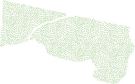
study (Figure 1). Width of corridor, density of trees, distance to the night and day (Table 1).
nearest road, slope of ground and disturbance were modelled in vari- All camera traps detected elephants. One camera detected only
ous combinations as predictors to determine which factors influ- diurnal activity and one only nocturnal, all other cameras detected
enced detection of elephants. Occupancy analysis included only elephants both nocturnally and diurnally (Figure 1). As there was a
camera‐trapping sites with data on all variables (n = 23 sites). Models difference in nocturnal versus diurnal use patterns (Table 1) separate
were ranked according to AIC values, where there was uncertainty models were run based on detections during the day and during the
over the best model, model averaging was used and parameter esti- night within each 24‐hr survey period. The highest ranking diurnal
mates are given based on averaging of models with ΔAIC < 2. model had reasonable support, with no other model coming within Δ
Journey speeds were calculated for three easily recognizable AIC < 2 (Table 2, Appendix). Model output on logit scale gives an
adult bulls, and for all identified family groups. Journeys were occupancy estimate of 3.09 (±1.03 SE), which when back‐trans-
recorded as separate events when an individual or group was formed indicates a 0.957 probability for site occupancy. Detection
believed to have left and re‐entered the corridor on the basis of was negatively influenced by disturbance, corridor width, slope of
detections near the corridor entrance or exit following or preceding ground and tree density (Table 3). There was more uncertainty as to
a 24‐hr period of non‐detection. For each journey, average speeds the best nocturnal model, with the top three models all within Δ
were calculated for movements within each of the vegetation AIC < 2, (Table 2). Model average outputs shows an occupancy esti-
classes. A repeated‐measures ANOVA with vegetation class as a mate of 3.19 (±1.13 SE) which equates to a 0.96 probability for site
fixed factor and elephant ID as a random factor tested for differ- occupancy. Detection patterns at night differed slightly to during the
ences in average speed amongst these classes. Analysis was per- day (Figure 1) and distance to nearest road had more of an influ-
formed on square‐root transformed data in order to improve ence, with more detections at closer distances to the road. Distur-
homogeneity of variances. bance had a smaller effect, and slope had no influence on nocturnal
Elephant trapping rates were calculated as the number of inde- detection (Table 3).
pendent photo capture events at a site divided by the number of Elephants travelled at different speeds in different areas of the
active camera trapping days. Proportion of trees showing elephant corridor (F2,7 = 13.19, p < 0.01, Figure 2). Speeds were fastest864 | GREEN ET AL.
Legend
200
0
215 20
0 50
21
00
220
0
Nanyuki - Meru A2 Highway
22
50
2300
Camera trap location with percentage
of total nights/days elephants were detected on 23
50
D 240
0
24
50
25
00
D481 Unpaved road
2500
2550
2600
2650
0 0.5 1 2 3 4
Kilometers
F I G U R E 1 Position of camera traps within the Mount Kenya Elephant Corridor, Meru County, Kenya, showing the percentage of active
trapping days and trapping nights during which elephants were detected [Colour figure can be viewed at wileyonlinelibrary.com]
T A B L E 1 Number of trapping events and proportion of nocturnal varied in speed (F4,7 = 16.84, p < 0.01). Average speed of family
and diurnal elephant capture events that occurred at sites with and
groups was higher (mean = 1.24 km/h ± 0.24 SE) than for adult bulls
without cattle regularly present
(mean = 0.65 km/h ± 0.10 SE). The highest speed calculated was
Cattle present Cattle absent 4.26 km/h, for a family group travelling through vegetation class one.
Time Trapping events Proportion Trapping events Proportion The lowest speed was 0.03 km/h for an adult bull travelling through
Day 33 0.13 217 0.49 vegetation class three. Average slope was steeper within classes
Night 215 0.87 229 0.51 three (mean = 7.47° ± 0.73 SE) and two (mean = 8.42° ± 1.25 SE)
than within class one (mean = 5.15° ± 0.93 SE). Range of slope val-
through vegetation class one (mean = 1.38 km/h ± 0.31 SE), interme- ues was greater within class three (max = 14.37°, min = 3.96°) than
diate through class two (mean = 0.94 km/h ± 0.16 SE) and slowest classes two (max = 12.40°, min = 5.33°) and one (max = 8.65°, min =
through class three (mean = 0.49 km/h ± 0.12 SE). Individuals also 3.72°).GREEN ET AL. | 865
T A B L E 2 Model selection results for covariate effects on detectability. Top five models and the global model are given for each of diurnal
and nocturnal data sets
Cumulative
Model AIC Δ AIC AIC weight AIC weight
Diurnal Width + Tree*Disturbance + Slope 1046.59 0.00 0.59 0.59
models Width + Road + Tree*Disturbance + Slope 1048.58 2.00 0.22 0.81
Width + Tree*Disturbance 1049.77 3.18 0.12 0.93
Width + Road + Tree*Disturbance 1050.91 4.32 0.068 0.99
Width + Tree + Disturbance + Slope 1058.38 11.79 0.002 1.00
Null Model 1081.44 34.85866 | GREEN ET AL.
1.0
0.8 y = 0.074 + 0.482x
Damaged fraction of trees
0.6
0.4
0.2
F I G U R E 3 The arcsine‐root
0.0
transformed proportion of trees surveyed
that had suffered elephant damage at a
0.0 0.2 0.4 0.6 0.8 1.0
site in relation to trapping rate of
Elephant trapping rate elephants at that site
During our study we recorded elephants in 694 capture events caution, but should not be dismissed as they can provide a meaning-
distributed throughout the corridor. This demonstrates that the cor- ful indication of intensity of use.
ridor is clearly valuable as it is heavily utilized and successfully con- During the day, elephants preferred sites with lower disturbance,
nects two protected areas. Nevertheless, our data show detection as and were detected more regularly in the northern part of the corri-
well as speed of movement varies throughout the corridor, indicating dor, where human activity is lower. Width of corridor is known to
that different parts of the corridor have different primary functions influence corridor use, with wider corridors being preferred (Hilty &
for elephants. Merenlender, 2004). Conversely, in the MKEC, width of corridor cor-
Occupancy models can be used to answer a range of biological related negatively with elephant detections. It is possible that detec-
questions (Mackenzie et al., 2002; Royle & Nichols, 2003). One tions were higher at sites in narrow parts of the corridor as animals
assumption of a single‐season occupancy model is that of closure, were funnelled past the cameras. Despite some sections of corridor
i.e. no movement into or out of sites between surveys. Where this being very narrow, this did not seem to prevent use of these areas
assumption is not met, occupancy can be interpreted as probability or inhibit passage through the corridor, indicating that even small
of use (Kéry & Royle, 2015). In the MKEC, probability of site occu- areas of protected land can help provide connectivity. These narrow
pancy was 0.96 for diurnal and nocturnal models. Interpreting this as sections are short and intermittent, however, and therefore unlikely
use rather than occupancy indicates a very high probability that all to be representative of how elephants might use a wholly narrow
sites within the corridor are used during the day and night. This lack corridor.
of variation in occupancy precluded meaningful modelling of it, and During the night, pattern of use shifted and sites closer to roads
so covariates were used to model detection. Our use of detection to were used more frequently. Although elephants have been known to
model elephant site preferences within the corridor is akin to using avoid roads (Blake et al., 2008), traffic reduces at night, particularly
presence only data or trapping rates. These methods assume perfect on the small, non‐paved roads in this remote area. Removal of cattle
detection, so it is hard to separate detectability from actual rate of would have further reduced overall disturbance levels in the corridor.
use. Nevertheless, such data still perform well in predicting species Disturbance had a smaller effect during the night, likely due to
distributions, and can provide biologically meaningful results for pop- reduction in disturbance level, although its effect indicates more dis-
ulations with high detection probabilities (Lazenby & Dickman, 2013; turbed sites are still avoided. Increased nocturnal activity is a well‐
Rood, Ganie, & Nijman, 2010; Van Bommel & Johnson, 2016). Ele- documented strategy employed by elephants to avoid contact with
phants are large and so relatively easy to detect and, as all cameras humans (Cook, Henley, & Parrini, 2015; Galanti, Preatoni, Martinoli,
were positioned on known elephant trails, it is likely that elephants Wauters, & Tosi, 2006; Graham, Douglas‐Hamilton, et al., 2009). It is
using a site would be detected over the course of a survey period. likely some temporal avoidance of anthropogenic activity by ele-
Ignoring the influence of abundance on detection may cause as phants is occurring, and that they are passing sites that are more
much bias as ignoring the effects of non‐detection (Welsh, Linden- heavily disturbed during the day, such as near roads, at night in
mayer, & Donnelly, 2013). Therefore, interpretation of the effects of order to avoid disturbance. This is supported by the lower trapping
the modelled covariates on detectability should be done with rates during the day at sites where cattle were grazed.GREEN ET AL. | 867 Another strategy used to avoid anthropogenic disturbance is suggest that the areas of the corridor where movement was slowest increased transit speed (Douglas‐Hamilton et al., 2005; Graham, are being treated primarily as habitat extension and that the areas Douglas‐Hamilton, et al., 2009). Although there was some variation which are traversed at higher speeds have limited value as habitat, between individuals, elephants generally moved more quickly due to increased disturbance and lower forage diversity (Codron et through vegetation class one, suggesting that it presented a higher al., 2011; De Boer, Ntumi, Correia, & Mafuca, 2000) but are used perceived risk. As navigation of steep slopes can be costly for ele- primarily for transit. phants in terms of energy and injury risk (Wall, Douglas‐Hamilton, & Electrified fencing is increasingly used to successfully alleviate Vollrath, 2006), differences in slope between our vegetation classes human–elephant conflict (Graham, Gichohi, et al., 2009; Kioko, may have confounded data slightly. This would still not fully explain Muruthi, Omondi, & Chiyo, 2008). Fencing areas comes at the the difference in speed between classes one and three. While aver- cost of restricting movement, which may involve obstruction of age incline in class three was greater than in class one, highest aver- historic corridor routes (Graham, Gichohi, et al., 2009). Restriction age incline was through class two, where intermediate speeds were of movement raises the potential for overexploitation of recorded. Moreover, there is considerable variability in slope resources (Guldemond & Van Aarde, 2008), and thereby increased throughout class three so not all movement in this area required human–wildlife conflict as elephants turn to crop raiding to fill traversal of steep slopes. If the costs of navigating slopes were dra- their nutritional needs (Cook et al., 2015; Galanti et al., 2006). matically influencing movement, elephants would be expected to use Many reserves now face the problem of managing high densities sites with steeper slopes less frequently. Within our models of corri- of elephants and associated overexploitation of vegetation (Lom- dor use, slope had some effect on use during the day but not during bard, Johnson, Cowling, & Pressey, 2001; Van Aarde & Jackson, the night, implying that it was not simply the gradient of the land 2007). In the case of the MKEC, there are already concerns that was influencing detection and other factors may be more regarding overexploitation of vegetation on LWC and in Ngare important. Ndare forest (LWC, 2015; Mwambeo & Maitho, 2015). Prior to Bulls often travel at faster speeds (Duffy, Dai, Shannon, Slotow, construction of the MKEC fence the corridor route was used by & Page, 2011; Ngene et al., 2010), yet, in our study, the fastest some elephants, leading to repeated crop raiding incidents. By speed was shown by a family group. The slight variation in calcula- fencing the corridor, it can enhance connectivity, thus reducing tion methods for bull and family group speeds does not explain the ecological impacts of fencing a reserve, while reducing risk of lower speed for bulls, as any slight bias would have increased bull human–wildlife conflict. speed relative to family group speed. Family groups are generally Overall, the evidence suggests that the more open, southern part more cautious than adult bulls, participating less in crop raiding and of the corridor is predominantly used by elephants for travel, and expanding into new areas more slowly (Chiyo & Cochrane, 2005; that this occurs mostly during the night. The northern section of the Druce et al., 2008; Hoare, 1999). The high transit speed is likely to corridor has a more diverse function and serves as additional forage be a reflection of this cautious behaviour. Cameras were able to pick and cover, effectively as an extension of the contiguous NNFR habi- up fine scale movement where these higher speeds were logged, tat. This idea is supported by the observations of identified family with identified elephants recorded by different cameras within groups. As the “Liqueurs” only used the northern part of the corri- 30 min. Overall, movement speed was underestimated, as distances dor, it appears that their use of the corridor was primarily as an were calculated as straight lines between cameras, which does not extension of habitat. Conversely the other family appear to traverse reflect exact paths taken. While speed over the ground is not accu- the corridor in order to access resources within the corridor itself rate, it is indicative of movement behaviour and suggests that ele- and the NNFR. For this group, the corridor provides both additional phants were spending more time in areas with good cover, increased habitat and a safe transit route. Regardless of the nature of the browsing opportunities and lower disturbance. movement our data clearly indicate that elephant have access to Elephants will spend more time in areas where forage is available additional resources because of the corridor and that it successfully (Gara et al., 2016) and travel more slowly when feeding (Ngene et connects the MKNP populations with those further north, in the al., 2010), so slow speeds may reflect increased foraging behaviour landscape beyond the corridor. in vegetation classes two and three. This idea is supported by the It has been suggested that some parts of the corridor are not positive relationship between elephant trapping rate and proportion used by elephants, and corridor size has been reduced since its origi- of trees showing damage, as this suggests that elephants could be nal construction. Our study found this idea to be inaccurate, and using favoured areas more intensely in order to forage. Although showed that all parts of the corridor are utilized. Several recommen- tree density had a slight negative effect in our models, tree density dations can be made to encourage sustained use of the corridor and as a measure of vegetation may have been distorted by the presence promote elephant movement through the entire corridor length. of shrubs and forbs. These were not included in the survey but pro- These include protecting the corridor width and managing human vided additional cover and food resources in some areas where tree activity within the corridor. It may be prudent to create additional density was low. Grasses can also be an important food source for corridors linking Mount Kenya to other areas of elephant habitat elephants (Cerling et al., 2006; Codron et al., 2011) and they were surrounding the mountain. As human activity can lead to reduced photographed feeding in the open grassland at night. Our results corridor functionality (Jones et al., 2012; Kioko & Seno, 2011)
868   |                                                                                                                                         GREEN   ET AL.

protection of land may be necessary in order to maintain benefits                    African elephant inferred from carbon isotope analysis of feces.
provided by corridors.                                                               Oecologia, 165(1), 89–99. https://doi.org/10.1007/s00442-010-1835-
                                                                                     6
                                                                                 Cook, R. M., Henley, M. D., & Parrini, F. (2015). Elephant movement pat-
                                                                                     terns in relation to human inhabitants in and around the Great Lim-
ACKNOWLEDGEMENTS
                                                                                     popo Transfrontier Park. Koedoe, 57(1), 1–7. https://doi.org/10.4102/
                                                                                     koedoe.v57i1.1298
The study was carried out in partnership with Lewa Wildlife Conser-
                                                                                 Crooks, K. R., Burdett, C. L., Theobald, D. M., Rondinini, C., & Boitani, L.
vancy, Mount Kenya Trust, Marania and Kisima Farms and Ngare                         (2011). Global patterns of fragmentation and connectivity of mam-
Ndare Forest Trust. We thank Susannah Rouse for her insights from                    malian carnivore habitat. Philosophical Transactions of the Royal Soci-
years of observing and recording elephant at LWC. Research permis-                   ety of London. Series B, Biological Sciences, 366(1578), 2642–2651.
                                                                                     https://doi.org/10.1098/rstb.2011.0120
sions were provided by the National Ministry for Science, Technol-
                                                                                 Davey, K., Wacher, T., & Amin, R. (2015). Analysis tool for camera trap
ogy and Innovation in Kenya (NACOSTI/P/15/8710/5044), through                        survey data, ZSL.
Marwell's local field biologist. Camera traps were made available                De Boer, W. F., Ntumi, C. P., Correia, A. U., & Mafuca, J. M. (2000). Diet
through collaboration facilitated by Mr G. Gibbon. The study forms                   and distribution of elephant in the Maputo Elephant Reserve. Mozam-
part of the requirements for the degree Master of Science by                         bique. African Journal of Ecology, 38(3), 188–201. https://doi.org/10.
                                                                                     1046/j.1365-2028.2000.00243.x
Research (MRES Conservation Biology), hosted jointly by Marwell
                                                                                 Dixon, J. D., Oli, M. K., Wooten, M. C., Eason, T. H., Cown, J. W. M. C.,
Wildlife and the University of Southampton. We thank Dr. Phil                        & Paetkau, D. (2006). Two Florida Black Bear Populations. Conserva-
Riordan and an anonymous reviewer for helpful comments and                           tion Biology, 20(1), 155–162. https://doi.org/10.1111/j.1523-1739.
suggestions.                                                                         2006.00292.x
                                                                                 Douglas-Hamilton, I., Krink, T., & Vollrath, F. (2005). Movements and cor-
                                                                                     ridors of African elephants in relation to protected areas. Naturwis-
                                                                                     senschaften, 92(4), 158–163. https://doi.org/10.1007/s00114-004-
ORCID
                                                                                     0606-9
                                                                                 Druce, H. C., Pretorius, K., & Slotow, R. (2008). The response of an ele-
Siân E. Green      http://orcid.org/0000-0003-0513-8490
                                                                                     phant population to conservation area expansion: Phinda Private
                                                                                     Game Reserve. South Africa. Biological Conservation, 141(12), 3127–
                                                                                     3138. https://doi.org/10.1016/j.biocon.2008.09.024
REFERENCES                                                                       Duffy, K. J., Dai, X., Shannon, G., Slotow, R., & Page, B. (2011). Move-
                                                                                     ment patterns of African elephants (Loxodonta africana) in different
Bennett, A. F. (2003). Linkages in the landscape: The role of corridors              habitat types. South African Journal of Wildlife Research, 41(1), 21–28.
    and connectivity in wildlife conservation. IUCN (Vol. 24). https://doi.          https://doi.org/10.3957/056.041.0107
    org/10.2305/iucn.ch.2004.fr.1.en                                             Epps, C. W., Wasser, S. K., Keim, J. L., Mutayoba, B. M., & Brashares, J.
Blake, S., Deem, S. L., Strindberg, S., Maisels, F., Momont, L., Isia, I., …         S. (2013). Quantifying past and present connectivity illuminates a
    Kock, M. D. (2008). Roadless Wilderness Area Determines Forest Ele-              rapidly changing landscape for the African elephant. Molecular Ecol-
    phant Movements in the Congo Basin. PLoS ONE, 3(10), https://doi.                ogy, 22(6), 1574–1588. https://doi.org/10.1111/mec.12198
    org/10.1371/journal.pone.0003546                                             ESRI. (2015). ArcGIS desktop: Release 10.3.1. Redlands, CA: Environmental
Brodie, J. F., Giordano, A. J., Dickson, B., Hebblewhite, M., Bernard, H.,           Systems Research Institute.
    Mohd-azlan, J., & Anderson, J. (2014). Evaluating Multispecies Land-         Fiske, I. J., & Chandler, R. B. (2011). unmarked: An R package for fitting
    scape Connectivity in a Threatened Tropical Mammal Community.                    hierarchical models of wildlife occurrence and abundance. Journal of
    Conservation Biology, 29(1), 122–132. https://doi.org/10.1111/cobi.              Statistical Software, 43(August 2011), 1–23. https://doi.org/10.1002/
    12337                                                                            wics.10
Castellón, T. D., & Sieving, K. E. (2006). An experimental test of matrix        Flather, C. H., & Bevers, M. (2002). Patchy Reaction Diffusion and Popu-
    permeability and corridor use by an endemic understory bird. Conser-             lation Abundance: The Relative Importance of Habitat Amount and
    vation Biology, 20(1), 135–145. https://doi.org/10.1111/j.1523-1739.             Arrangement. The American Naturalist, 159(1), 40–56. https://doi.org/
    2006.00332.x                                                                     10.1086/324120
Ceballos, G., Ehrlich, P. R., Barnosky, A. D., García, A., Pringle, R. M., &     Gadd, M. E. (2005). Conservation outside of parks: Attitudes of local
    Palmer, T. M. (2015). Accelerated modern human – induced species                 people in Laikipia. Kenya. Environmental Conservation, 32(1), 50–63.
    losses: Entering the sixth mass extinction. Sciences Advances, 1                 https://doi.org/10.1017/S0376892905001918
    (e1400253), 1–5. https://doi.org/10.1126/sciadv.1400253                      Galanti, V., Preatoni, D., Martinoli, A., Wauters, L. A., & Tosi, G. (2006).
Cerling, T. E., Wittemyer, G., Rasmussen, H. B., Vollrath, F., Cerling, C. E.,       Space and habitat use of the African elephant in the Tarangire‐Man-
    Robinson, T. J., & Douglas-Hamilton, I. (2006). Stable isotopes in ele-          yara ecosystem, Tanzania: Implications for conservation. Mammalian
    phant hair document migration patterns and diet changes. Proceedings             Biology, 71(2), 99–114. https://doi.org/10.1016/j.mambio.2005.10.
    of the National Academy of Sciences of the United States of America,             001
    103(2), 371–373. https://doi.org/10.1073/pnas.0509606102                     Gara, T. W., Wang, T., Skidmore, A. K., Zengeya, F. M., Ngene, S. M.,
Chege, G. (2011). The Mount Kenya Elephant Corridor Goes Live. Lewa                  Murwira, A., & Ndaimani, H. (2016). Understanding the effect of
    News, 31, 4.                                                                     landscape fragmentation and vegetation productivity on elephant
Chiyo, P. I., & Cochrane, E. P. (2005). Population structure and behaviour           habitat utilization in Amboseli ecosystem. Kenya. African Journal of
    of crop‐raiding elephants in Kibale National Park. Uganda. African               Ecology, 1–11, https://doi.org/10.1111/aje.12346
    Journal of Ecology, 43(3), 233–241. https://doi.org/10.1111/j.1365-          Gilbert-Norton, L., Wilson, R., Stevens, J. R., & Beard, K. H. (2010). A
    2028.2005.00577.x                                                                Meta‐Analytic Review of Corridor Effectiveness. Conservation Biol-
Codron, J., Codron, D., Lee-Thorp, J. A., Sponheimer, M., Kirkman, K.,               ogy, 24(3), 660–668. https://doi.org/10.1111/j.1523-1739.2010.
    Duffy, K. J., & Sealy, J. (2011). Landscape‐scale feeding patterns of            01450.x
GREEN ET AL. | 869
Graham, M. D., Douglas-Hamilton, I., Adams, W. M., & Lee, P. C. (2009). Lees, A. C., & Peres, C. A. (2008). Conservation value of remnant riparian
The movement of African elephants in a human‐dominated land‐use forest corridors of varying quality for Amazonian birds and mammals.
mosaic. Animal Conservation, 12(5), 445–455. https://doi.org/10. Conservation Biology, 22(2), 439–449. https://doi.org/10.1111/j.1523-
1111/j.1469-1795.2009.00272.x 1739.2007.00870.x
Graham, M. D., Gichohi, N., Kamau, F., Aike, G., Craig, B., Douglas-Hamil- Litoroh, M., Omondi, P., Kock, R., & Amin, R. (2012). Conservation and
ton, I., & Adams, W. M. (2009). The Use of Electrified Fences to management strategy for the elephants in Kenya. 2012–2021. Nairobi:
Reduce Human Elephant Conflict: A Case Study of the Ol Pejeta The Kenya Wildlife Service (KWS).
Conservancy, Laikipia District, Kenya, Working Paper 1, Laikipia Ele- Lombard, A. T., Johnson, C. F., Cowling, R. M., & Pressey, R. L. (2001).
phant Project, Nanyuki, Kenya. Protecting plants from elephants: Botanical reserve scenarios within
Guldemond, R., & Van Aarde, R. U. D. I. (2008). A Meta‐Analysis of the the Addo Elephant National Park, South Africa. Biological Conserva-
Impact of African Elephants on Savanna Vegetation. Journal of Wild- tion, 102, 191–203. https://doi.org/10.1016/S0006-3207(01)00056-
life Management, 72(4), 892–899. https://doi.org/10.2193/2007-072 8
Haddad, N. M., Bowne, D. R., Cunningham, A., Danielson, B. J., Levey, D. LWC (2015). Research and Wildlife Monitoring Report July to Septem-
J., Sargent, S., & Spira, T. I. M. (2003). Corridor Use By Diverse Taxa. ber, 2015.
Ecology, 84(3), 609–615. https://doi.org/10.1890/0012-9658(2003) Mackenzie, C. A., & Ahabyona, P. (2012). Elephants in the garden: Finan-
084[0609:CUBDT]2.0.CO;2 cial and social costs of crop raiding. Ecological Economics, 75, 72–82.
Haddad, N. M., & Tewksbury, J. J. (2005). Low‐quality habitat corridors https://doi.org/10.1016/j.ecolecon.2011.12.018
as movement conduits for two butterfly species. Ecological Applica- Mackenzie, D. I., Nichols, J. D., Lachman, G. B., Droege, S., Royle, J. A., &
tions, 15(1), 250–257. https://doi.org/10.1890/03-5327 Langtimm, C. A. (2002). Estimating Site Occupancy Rates When
Hess, G. (1996). Disease in Metapopulation Models: Implications for Con- Detection Probabilities Are Less Than One. Ecology, 83(8), 2248–
servation. Ecology, 77(5), 1617–1632. https://doi.org/10.2307/ 2255. https://doi.org/10.1890/0012-9658(2002)083[2248:ESORWD]
2265556 2.0.CO;2
Hilty, J. A., & Merenlender, A. M. (2004). Use of Riparian Corridors and Mech, S. G., & Hallett, J. G. (2001). Evaluating the Effectiveness of Corri-
Vineyards by Mammalian Predators in Northern California. Conserva- dors : A Genetic Approach. Conservation Biology, 15(2), 467–474.
tion Biology, 18(1), 126–135. https://doi.org/10.1111/j.1523-1739. https://doi.org/10.1046/j.1523-1739.2001.015002467.x
2004.00225.x Mitchell, K. (2007). Quantitative analysis by the point‐centered quarter
Hoare, R. E. (1999). Determinants of human‐elephant conflict in a land‐ method. Quantitative Methods, 1–34.
use mosaic. Journal of Applied Ecology, 36(5), 689–700. https://doi. Mora, C., & Sale, P. F. (2011). Ongoing global biodiversity loss and the
org/10.1046/j.1365-2664.1999.00437.x need to move beyond protected areas: A review of the technical and
Horskins, K., Mather, P. B., & Wilson, J. C. (2006). Corridors and connec- practical shortcomings of protected areas on land and sea. Marine
tivity: When use and function do not equate. Landscape Ecology, 21 Ecology Progress Series, 434, 251–266. https://doi.org/10.3354/me
(5), 641–655. https://doi.org/10.1007/s10980-005-5203-6 ps09214
Jarvis, A., Reuter, H. I., Nelson, A., & Guevara, E. (2008). Hole-filled Mwambeo, H. M., & Maitho, T. (2015). Factors Influencing Elephants To
SRTM for the globe Version 4, available from the CGIAR-CSI SRTM Destroy Forest Trees Especially Olea africana: The Case of Ngare
90 m Database (http://srtm.csi.cgiar.org). Ndare Forest Reserve in Meru County, Kenya. Ethiopian Journal of
Jones, T., Bamford, A. J., Ferrol-Schulte, D., Hieronimo, P., Mcwilliam, N., Environmental Studies & Management, 8(4), 398–407. https://doi.org/
& Rovero, F. (2012). Vanishing wildlife corridors and options for 10.4314/ejesm.v8i4.5
restoration : A case study from Tanzania. Tropical Conservation Ngene, S., Njumbi, S., Nzisa, M., Kimitei, K., Mukeka, J., Muya, S., …
Science, 5(4), 463–474. https://doi.org/10.1177/ Omondi, P. (2013). Status and trends of the elephant population in
194008291200500405 the Tsavo – Mkomazi ecosystem. Pachyderm, 53(53), 38–50.
Kéry, M., & Royle, J. A. (2015). Applied hierarchical modeling in ecology: Ngene, S. M., Van Gils, H., Van Wieren, S. E., Rasmussen, H., Skidmore,
Analysis of distribution, abundance and species richness in R and BUGS: A. K., Prins, H. H. T., … Douglas-Hamilton, I. (2010). The ranging pat-
Volume 1: Prelude and Static Models. London: Academic Press. terns of elephants in Marsabit protected area, Kenya: The use of
Kioko, J., Herbert, V., Mwetta, D., Kilango, Y., Murphy-Williams, M., & satellite‐linked GPS collars. African Journal of Ecology, 48(2), 386–400.
Kiffner, C. (2015). Environmental Correlates of African Elephant (Lox- https://doi.org/10.1111/j.1365-2028.2009.01125.x
odonta africana) Distribution in Manyara Area, Tanzania. Annual R Core Team (2017). R: A language and environment for statistical comput-
Research & Review in Biology, 5(2), 147–154. https://doi.org/10.9734/ ing. Vienna, Austria: R Foundation for Statistical Computing. Available
ARRB/2015/12470 at: http://www.r-project.org/.
Kioko, J. M., Muruthi, P., Omondi, P., & Chiyo, P. I. (2008). The perfor- Rood, E., Ganie, A. A., & Nijman, V. (2010). Using presence‐only mod-
mance of electric fences as elephant barriers in Amboseli, Kenya. elling to predict Asian elephant habitat use in a tropical forest land-
South African Journal of Wildlife Research, 38(1), 52–58. https://doi. scape: Implications for conservation. Diversity and Distributions, 16,
org/10.3957/0379-4369-38.1.52 975–984. https://doi.org/10.1111/j.1472-4642.2010.00704.x
Kioko, J. M., & Seno, S. O. (2011). Elephant corridor use and threats in Rowcliffe, J. M., Carbone, C., Kays, R., Kranstauber, B., & Jansen, P. A.
the eastern range of Amboseli elephants. Kenya. Pachyderm, 49(1), (2012). Bias in estimating animal travel distance : The effect of sam-
70–78. https://doi.org/10.1017/S0266467498000406 pling frequency. Methods in Ecology and Evolution, 3(4), 653–662.
Lapoint, S., Gallery, P., Wikelski, M., & Kays, R. (2013). Animal behavior, https://doi.org/10.1111/j.2041-210X.2012.00197.x
cost‐based corridor models, and real corridors. Landscape Ecology, 28, Royle, A. J., & Nichols, J. D. (2003). Estimating Abundance from
1615–1630. https://doi.org/10.1007/s10980-013-9910-0 Repeated Presence‐Absence Data or Point Counts. Ecology, 84, 777–
Lazenby, B. T., & Dickman, C. R. (2013). Patterns of detection and cap- 790. https://doi.org/10.1890/0012-9658(2003)084[0777:EAFRPA]2.
ture are associated with cohabiting predators and prey. PLoS ONE, 8, 0.CO;2
e59846. https://doi.org/10.1371/journal.pone.0059846 Shannon, G., Page, B. R., Duffy, K. J., & Slotow, R. (2010). The ranging
Lebas, N. R. (2002). Mate Choice, Genetic Incompatibility, and Outbreed- behaviour of a large sexually dimorphic herbivore in response to sea-
ing in the Ornate Dragon Lizard. Ctenophorus ornatus. Evolution, 56 sonal and annual environmental variation. Austral Ecology, 35(7), 731–
(2), 371–377. https://doi.org/10.1111/j.0014-3820.2002.tb01347.x 742. https://doi.org/10.1111/j.1442-9993.2009.02080.x870 | GREEN ET AL.
Shannon, G., Page, B., Slotow, R., & Duffy, K. (2006). African elephant Wall, J., Douglas-Hamilton, I., & Vollrath, F. (2006). Elephants avoid
home range and habitat selection in Pongola Game Reserve. South costly mountaineering. Current Biology, 16, 527–529. https://doi.org/
Africa. African Zoology, 41(1), 37–44. https://doi.org/10.3377/1562- 10.1016/j.cub.2006.06.049
7020(2006) 41[37:AEHRAH]2.0.CO;2 Wall, J., Wittemyer, G., Klinkenberg, B., LeMay, V., & Douglas-Hamilton,
Thomas, C. D., Cameron, A., Green, R., Bakkenes, M., Beaumont, L. J., I. (2013). Characterizing properties and drivers of long distance
Collingham, Y. C. … Williams, S. E. (2004). Extinction risk from cli- movements by elephants (Loxodonta africana) in the Gourma, Mali.
mate change. Nature, 427, 145–148.https://doi.org/10.1038/nature Biological Conservation, 157, 60–68. https://doi.org/10.1016/j.biocon.
02121 2012.07.019
Thouless, C. R. (1994). Conflict between humans and elephants on pri- Warde, W., & Petranka, J. W. (1981). A Correction Factor Table for Miss-
vate land in northern Kenya. Oryx, 28(2), 119. https://doi.org/10. ing Point‐Center Quarter Data. Ecology, 62(2), 491–494. https://doi.
1017/S0030605300028428 org/10.2307/1936723
Time and Date (2016, June 1). Sunrise and Sunset Times in Nairobi. Welsh, A. H., Lindenmayer, D. B., & Donnelly, C. F. (2013). Fitting and
[Online] Retrieved from http://www.timeanddate.com/sun/kenya/na Interpreting Occupancy Models. PLoS ONE, 8(1), e52015. https://doi.
irobi org/10.1371/journal.pone.0052015
Van Aarde, R. J., & Jackson, T. P. (2007). Megaparks for metapopulations:
Addressing the causes of locally high elephant numbers in southern
Africa. Biological Conservation, 134, 289–297. https://doi.org/10.
1016/j.biocon.2006.08.027 How to cite this article: Green SE, Davidson Z, Kaaria T,
Van Bommel, L., & Johnson, C. N. (2016). Livestock guardian dogs as sur- Doncaster CP. Do wildlife corridors link or extend habitat?
rogate top predators? How Maremma sheepdogs affect a wildlife
Insights from elephant use of a Kenyan wildlife corridor. Afr J
community. Ecology and Evolution, 6, 6702–6711. https://doi.org/10.
1002/ece3.2412 Ecol. 2018;56:860–871. https://doi.org/10.1111/aje.12541
APPENDIX
Model outputs from top 5 diurnal and nocturnal models based on AIC ranking, showing occupancy (ѱ) and estimated coefficients of covariates
used to model detection given on the logit scales with associated standard errors. Back‐transformed occupancy estimate is given to show
probability that a site is occupied (ѱ probability).
Model Covariate Estimate SE Z p
Diurnal 1
ѱ (SE) 3.09 (1.03) Detection: Intercept 0.204 0.515 0.0396 0.692
ѱ probability (SE) 0.96 (0.04) Corridor width −1.331 0.326 −4.078GREEN ET AL. | 871 APPENDIX (Continued) Model Covariate Estimate SE Z p Diurnal 4 ѱ (SE) 3.11 (1.04) Detection: Intercept −0.629 0.299 −2.103 0.035 ѱ probability (SE) 0.96 (0.04) Corridor width −1.095 0.311 −3.525
You can also read