Fracking California & the Delta
←
→
Page content transcription
If your browser does not render page correctly, please read the page content below
Fracking California & the Delta
A new method to get gas and oil out of the
ground was invented in 1998. “Horizontal
Fracturing” or simply “FRACKING”
development in California is very closely
related to the BDCP and the New Water Plan.
This presentation reviews the timeline of the
CALFED/BDCP as it relates to fracking
activities in and around the Delta.

Online references
for presentation to North Delta Cares
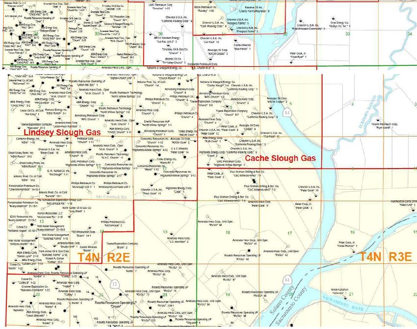
Which energy company has natural gas wells where in the Delta:
http://www.conservation.ca.gov/dog/maps/Pages/d6_index_map1.aspx
http://www.conservation.ca.gov/dog/maps/Pages/d6_index_map1.aspx
ftp://ftp.consrv.ca.gov/pub/oil/maps/dist6/610/Map610.pdf
ftp://ftp.consrv.ca.gov/pub/oil/maps/dist6/614/Map614.pdf
Waterflow on the Sacramento River near Clarksburg:
http://waterdata.usgs.gov/nwis/inventory/?site_no=11447650
Fracking injection wells (toxins left behind)
http://www.fractracker.org/2014/03/ca_injection_earthquakes/ go to the
interactive maps down the page to get to the class II injection well map.
http://deltarevision.com/deltagasexploration.html
http://deltarevision.com/timeline.htm *** Delta families need to review the
timeline!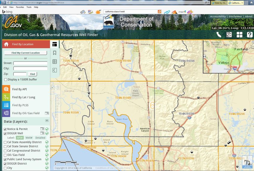
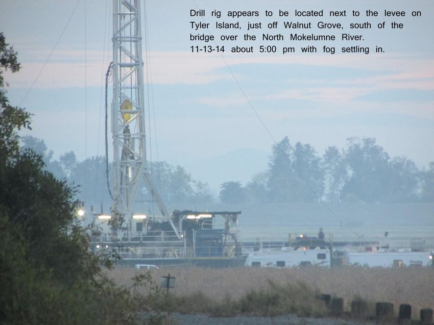
11-13-14 Tyler Island just off Walnut Grove Road, near Guisti’s, and
right next to a levee off the North Mokelumne River….. Is this a new
                        fracking well going in?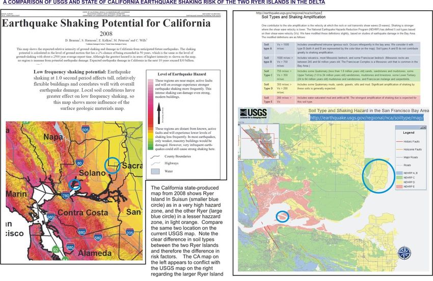
Timeline of CALFED-BDCP & Delta Fracking
    1997

http://www.DeltaREvision.com and go to the “timeline” page. You can point your mouse and click on the words to
go to pages or more information regarding the particular subject. Understanding who was doing what for what
reason at what time helps to make sense of what we’ve been seeing and experiencing here in the Delta!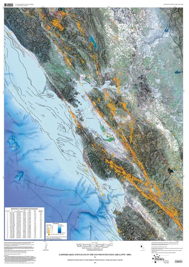
What is Fracking?
How can you create “integrated solutions” that will have sucessful outcomes if
you ignore the major source of water contamination?
Side profile of area wells, add fracking

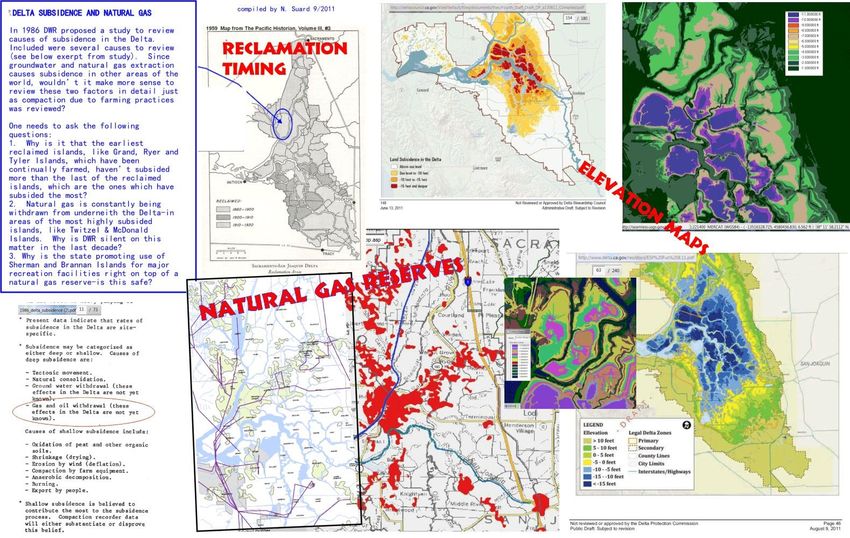
BDCP “forgot” to account for the impacts of reduced river flows: the aquifer
does not replenish, the water quality declines due to fracking residue, and there
is an increase in salinity of groundwater due to horizontal fracking-not just
saltwater encroachment from the Bay. Look into disposal of brine water from
fracking!
BDCP Delta natural gas reserves
Delta fracking maps
EPA fracking exemptions and SLC leases: Sacramento River and
              Steamboat Slough as early as 2004

                                           http://deltarevision.com/fracking/stream
                                           -sac.jpg

http://deltarevision.com/deltagasexploration.html
Other Delta locations where fracking wells have gone in…Sherman Island and the “seismic risk” studies:
DRMS Phase 1 reports and 2 Ryer Islands

Why didn’t the writers of the DRMS Phase 1 report disclose the concern that fracking might “induce”
seismic events? Does the prediction of earthquakes include computer assessment for fracking the area?
Injections wells-impacts from toxic chemicals left in the wells

 There are new
 “injection wells” in
 many areas of the
 Delta now. You can
 drive around and see
 new fracking locations
 off Hwy 12, on Andrus
 Island, Staten Island,
 possibly Ryer Island
 and in many areas of
 the Yolo Bypass. Why
 wasn’t the fact fracking
 is allowed in the Delta
 considered in the
 computer modeling-
 inpacts for the Delta?
Fracking causes sinkholes
Could sinkholes be the reason for
the missing water flow from Georgiana Slough or the deep hole
  under the Steamboat Slough bridge making the Steamboat
                   Landing beach disappear?
According to
Fractracker.org
a Class II injection
well (toxins) was
installed on Staten
Island. Since when
is the “Nature
Conservancy” in
favor of injecting
toxins into
groundwater?Missing water from Georgiana
and the dying oaksFracking the Yolo Bypass
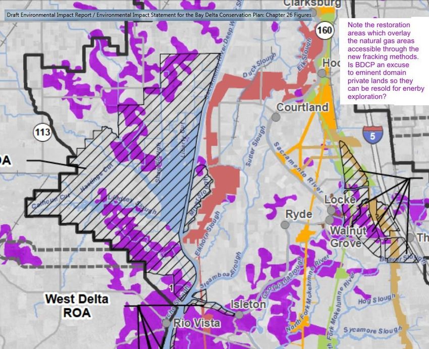
Why didn’t the BDCP address the impact of fracking
      on drinking water wells of the Delta?
BDCP “restoration” areas Why does it appear there are tule ponds near all the new fracking sites? Do tules help diffuse the toxins?
DRMS Phase 1 and many DWR documents focus on subsidence, but fail to recognize that fracking is known to
cause subsidence in other areas. Did DRMS scientists factor in the impacts of fracking subsidence when
determining the estimated rate of subsidence per island in the future?
Is there any credible study
 on the effects of fracking
   fluids on tules used to
  diffuse the toxic fluids?
 Effects on bugs, birds, fish
  and animals that reside
near or consume the tules?
Nearby “seismic event” which may have been instigated by
             fracking activities in the area…
The Napa & Vallejo quake
What can we do about this?
1. Have your drinking water well tested to make sure it is safe to
consume.
2. If you see a constant stream of truck and transfer loads going
by, report where they are going to the people running
http://fractracker.org or similar website. (Food & Water Watch)
3. Let your supervisors, assemblypersons, senators,
congresspersons, governor and president know FRACKING IS
BAD FOR CALIFORNIA DRINKING WATER (if the toxins are allowed
to be left behind to contaminate future drinking water)!
4. Learn more and share with others about fracking-they will not
get the whole truth from mainstream media! Book: The
Frackers. Report: On Shaky Ground. Online research keywords:
frack maps, fracturing, DOGGR at http://conservation.ca.gov etc.
Delta maps & documents: http://www.deltarevision.com
Online references
Which energy company is where in the Delta:
http://www.conservation.ca.gov/dog/maps/Pages/d6_index_map1.aspx

 http://www.conservation.ca.gov/dog/maps/Pages/d6_index_map1.aspx
 ftp://ftp.consrv.ca.gov/pub/oil/maps/dist6/610/Map610.pdf
 ftp://ftp.consrv.ca.gov/pub/oil/maps/dist6/614/Map614.pdf

 Waterflow on the Sacramento River near Clarksburg:
 http://waterdata.usgs.gov/nwis/inventory/?site_no=11447650

 Fracking injection wells (toxins left behind)
 http://www.fractracker.org/2014/03/ca_injection_earthquakes/ go to the
 interactive maps down the page to get to the class II injection well map.
11-13-14 Tyler Island just off Walnut Grove Road, near Guisti’s, and
right next to a levee off the North Mokelumne River….. Is this a new
                        fracking well going in?
11-13-14 presentation for North
Delta CaresFracking California & the Delta A new method to get gas and oil out of the ground was invented in 1998. “Horizontal Fracturing” or simply “FRACKING” development in California is very closely related to the BDCP and the New Water Plan. This presentation reviews the timeline of the CALFED/BDCP as it relates to fracking activities in and around the Delta.
You can also read