Geoarchaelogical Study of the Roman Pietra Dell'Oglio Bridge at the Service of the Old Appian Way, Campania, Southern Italy
←
→
Page content transcription
If your browser does not render page correctly, please read the page content below
Archaeological Discovery, 2021, 9, 223-258
                                                                                                 https://www.scirp.org/journal/ad
                                                                                                           ISSN Online: 2331-1967
                                                                                                             ISSN Print: 2331-1959

Geoarchaelogical Study of the Roman Pietra
Dell’Oglio Bridge at the Service of the Old
Appian Way, Campania, Southern Italy

Ugo Chiocchini1* , Mariella De Piano2, Mario Gaeta3, Erminio Pagliuca4, Nicola Polzone4,
Fiammetta Sarmento4

Formerly Professor of Engineering Geology at the Università Degli Studi della Tuscia, Italy
1

2
 Dipartimento Di Ingegneria Civile, Università Degli Studi Di Salerno, Salerno, Italy
3
 Dipartimento Di Scienze Della Terra, Sapienza Università Di Roma, Roma, Italy
4
 Geoconsultlab, Manocalzati, Avellino, Italy

How to cite this paper: Chiocchini, U., De     Abstract
Piano, M., Gaeta, M., Pagliuca, E., Polzone,
N., & Sarmento, F. (2021). Geoarchaelogical    The Pietra dell’Oglio bridge is the only Roman infrastructure that crosses the
Study of the Roman Pietra Dell’Oglio Bridge    Ofanto River between Mirabella Eclano (Aeclanum in Campania) and Venosa
at the Service of the Old Appian Way,
                                               (Venusia in Basilicata), just near the border between Campania and Basilica-
Campania, Southern Italy. Archaeological
Discovery, 9, 223-258.                         ta. The bridge was built on a substrate consisting of the stable middle Mi-
https://doi.org/10.4236/ad.2021.94012          ocene Cerreta-Bosco di Pietra Palomba Sandstone (ACP) and where the
                                               Ofanto River valley is narrower. The current state of the bridge shows that 18
Received: July 11, 2021
Accepted: September 24, 2021                   architectural and structural elements are original, 12 were restored, 1 was
Published: September 27, 2021                  modified, 4 were reconstructed, and 4 were added in the last century. The
                                               original architectural and structural elements (ASEs) are built by the tech-
Copyright © 2021 by author(s) and
                                               nique of opus quadratum and opus incertum using the pebbles of the Ofanto
Scientific Research Publishing Inc.
This work is licensed under the Creative       River and ashlars of phytoclastic travertine and ACP Sandstone cemented by
Commons Attribution International              very hard mortar. The opus incertum technique and its use for many bridges
License (CC BY 4.0).                           in Italy and France suggest that the Pietra dell’Oglio bridge was built between
http://creativecommons.org/licenses/by/4.0/
                                               the II and I century BC at the service of a very important public road. The
                Open Access
                                               present research is allowed to identify the Pietra dell’Oglio bridge with the
                                               Pons Aufidi related to the old Appian Way layout between Mirabella Eclano
                                               and Venosa and contributes to improving the knowledge of Roman bridge
                                               engineering, particularly in Campania.

                                               Keywords
                                               Geoarchaeology, Pietra Dell’Oglio Bridge, Old Appian Way, Opus Incertum,
                                               Campania

DOI: 10.4236/ad.2021.94012         Sep. 27, 2021                 223                                     Archaeological Discovery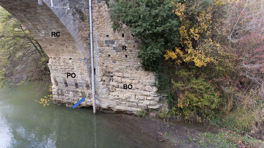
U. Chiocchini et al.
1. Introduction
Bridges are infrastructures of primary importance in the history of humanity
because they connect the peoples on Earth, facilitating communication between
them and allowing the exchange of civilizations and cultures. Bridges are essen-
tial for ancient and modern cities and for the road network, to overcome rivers
and smaller waterways. They were built in Roman times by valid designers and
civilian and military workers, often in conditions of difficult logistic and com-
plex morphological situations, by boats and ships, wood, masonry, and mixed
type of materials with masonry substructure and wooden superstructure.
Initially, the task of building roads and bridges was entrusted to magistrates
such as the censors, deprived of imperium, tribunes of the plebs, aedili, legacies
of the proconsuls. Subsequently, the impressive construction of roads and
bridges in the II and I centuries BC created a complex and expensive network of
urban and territorial infrastructures because they required, in addition to con-
struction, restoration, reconstruction and maintenance. The road network was
attributed to a particular and extraordinary magistrate: the Curator viarum, the
governance between the praetorship and the consulate. According to Tito Livio
from the II century BC the contract institute was applied (locatio conductio ope-
ris) to organize the works for the roads and bridges to tenant entrepreneurs
(conductores viarum).
The Roman roads were classified according to their importance, as reported
by the surveyor Siculus Flaccus (Adams, 2011).
Public roads were built at the expense of the State and with the name of the
builder.
Strategic roads were built by the army at its expense.
Secondary roads were built by villages (pagi).
Private roads were built by land and house owners.
Different bridges were needed for the construction of the old Appian Way, a
public road also known as Regina viarum, whose construction began in 312 BC
at the request of the censor Appio Claudio Cieco to connect Rome to the port of
Brindisi on the Adriatic Sea in Puglia. The enormous importance of this consu-
lar road on the connective, commercial and military lines was underlined by Pi-
sani Sartorio (2003), while Chiocchini et al. (2016) faced a little known aspect of
Regina viarum, contributing to the identification of its layout between Mirabella
Eclano (heir of the ancient Aeclanum, in the middle valley of the Calore River in
Campania) and Venosa (Venusia, Latin colony founded in 291 BC in Basilicata)
located in the Campania and Basilicata Apennine (Figure 1).
The bridge over the Ofanto River (Flumen Aufidus), also reported in the Ta-
bula Peutingeriana as Pons Aufidi, is a crucial issue in determining where the
layout of the old Appian Way between Mirabella Eclano and Venosa had to
cross this river in the area between Conza della Campania (heir of the ancient
Compsa) and the Santa Venere bridge (SVB) (Figure 2). It should be noted that
near Conza della Campania there was another Roman bridge over the Ofanto
DOI: 10.4236/ad.2021.94012 224 Archaeological Discovery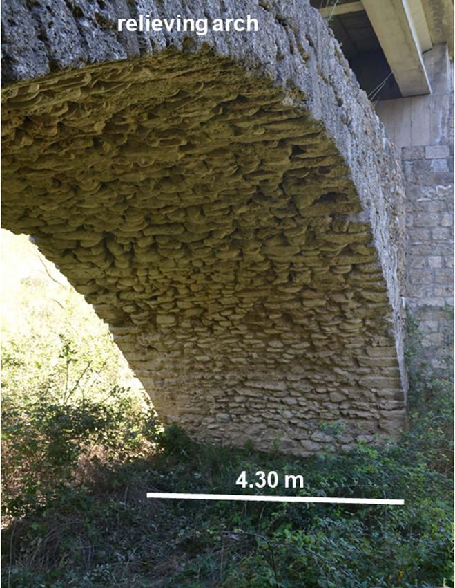
U. Chiocchini et al.

                Figure 1. Digital terrain model of the Campania and Basilicata Apennine with the location of cities (red
                squares), small towns (small red circles), streams, and Figure 2 (red rectangle).

                Figure 2. Digital terrain model illustrating the geological setting of the layouts proposed by the Authors for the
                old Appian Way between Mirabella Eclano (Aeclanum) and Venosa (Venusia). 1) tuffs and lavas (Pleistocene);
                2) gravels, sands and clays (Pliocene-Pleistocene); 3) Ruvo del Monte Synthem: conglomerates (a); sands and
                clays (b) (lower Pliocene-upper Pliocene); 4) Cerreta-Bosco di Pietra Palomba Sandstone (middle Miocene); 5)
                Numidian Flysch (lower Miocene); 6) calcareous member of the Varicolored Clays Formation: turbidite calca-
                renites and marls (lower Miocene); 7) Varicolored Clays Formation: clays, marls, marly and siliceous limes-
                tones, turbidite calcarenites (Cretaceous-lower Miocene); 8) Flysch galestrino: clays, marls, marly and siliceous
                limestones (lower Cretaceous); 9) 10) 11) 12) 13) hypothesis of the northern layouts; 14) hypothesis of the
                southern layout according to Chiocchini et al. (2016); 15) altitude m asl.

DOI: 10.4236/ad.2021.94012                                   225                                        Archaeological Discovery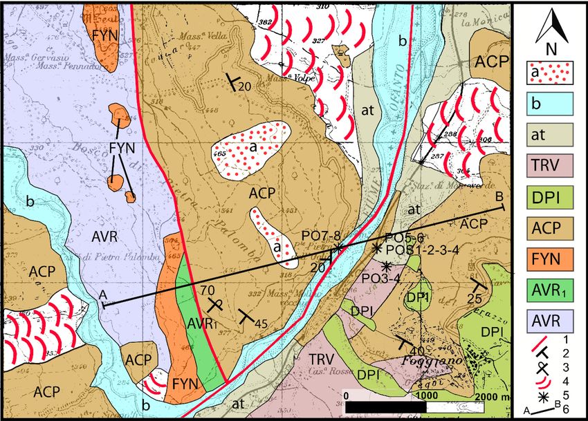
U. Chiocchini et al.

                             River, of which only one pier survived, at present submerged in the basin created
                             by the Conza della Campania dam (Aveta et al., 2012; Chiocchini et al., 2016).
                               Two hypotheses have been proposed for the layout of the old Appian Way
                             between Mirabella Eclano and Venosa: 1) the nortnern layouts (9, 10, 11, 12, 13
                             in Figure 2), which crossed the Ofanto River by the SVB, even if this bridge is
                             not really of Roman age, as specified later (Pratilli, 1745; Mommsen, 1848; Jan-
                             nacchini, 1889; Grasso, 1893; Guarini, 1909; Ashby, 1916-1917; Iacobone, 1935;
                             Lugli, 1952, 1963; Castagnoli, 1969; Alvisi, 1970; Radke, 1981; Stazio, 1987; Quilici,
                             1989, 2004; Flammia, 1995; Romito, 1995; Johannowsky, 1996; Tazzi, 1998; For-
                             naro, 2000; Della Portella, 2003; De Luca, 2003; Morano, 2003; Cera, 2011; Cerau-
                             do, 2011; Castrianni, 2013; Del Lungo, 2013; Lariccia, 2015; Marchi & Ferlazzo,
                             2015; Ceraudo, 2019); 2) the southern layout (14 in Figure 2), which crossed the
                             Ofanto River by the Pietra dell’Oglio bridge (POB) (Mannert, 1823; Lenormant,
                             1883; De Lorenzo, 1906; Buglione, 1929; Grassi, 2013). This latter hypothesis has
                             been deepened, updated, and documented by Chiocchini et al. (2016) with new
                             widely evident data that demonstrate how this layout is the shortest and most
                             convenient in terms of design and construction, and therefore the most reliable
                             alternative. The hypothesis of the southern layout with the POB was also adopted
                             by Vistoli (2019), while according to Marchi (2019a, 2019b), who deals with the
                             layout of the old Appian Way in Basilicata mentioning the specific arguments of
                             Chiocchini et al. (2016), it is doubtful whether the Pons Aufidi is the SVB or the
                             POB.
                               As for the POB, it should be noted that there is no specific study aimed at de-
                             scribing its current state, original architectural and structural elements and the
                             materials used for the construction, but only scarce, short and inaccurate informa-
                             tion is available on this bridge. In fact, De Lorenzo (1906) and the Gardner Col-
                             lection (Castrianni, 2013) show two fairly clear photos of the bridge, taken from
                             the left bank of Ofanto River, respectively NW down-stream and NW up-
                             stream. Guarini (1909) and Iacobone (1935) propose two small and unclear photos
                             of the Pietra dell’Olio bridge (later changed to Oglio) seen from NE (down-
                             stream). Buglione (1929) shows a partially unclear photo of the bridge that does
                             not allow to establish the point where it was taken. Gazzola (1963) indicates that
                             the bridge is divided into six large arches and only the two external ones and the
                             piers date back to the Roman age. Unfortunately, there is no evidence of the ex-
                             istence of structures of the Roman age, and in the very small picture, the bridge
                             cannot be seen clearly and neither how it is oriented. O’Connor (1993) incorpo-
                             rates the data of Gazzola (1963). Aveta et al. (2012), who studied the historical
                             bridges of Campania with reference to 26 Roman bridges, among which 4 located
                             in the province of Avellino (Santo Spirito bridge in Casalbore, Pietra dell’Oglio
                             bridge, Annibale’s bridge in San Mango sul Calore, Conza della Campania bridge),
                             describe the POB consisting of four asymmetric arches, of which the first and
                             third are semicircular, while the intermediate one is a reconstructed lowered
                             arch. Furthermore, the fourth arch “had previously been covered for the recon-

DOI: 10.4236/ad.2021.94012                        226                                      Archaeological Discovery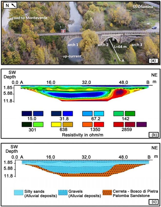
U. Chiocchini et al.

                             struction of the road to Monteverde, today visible with difficulty”. However, this
                             arch does not exist, as specified later. Very short references to the bridge are de-
                             scribed by Troncone (2013), who indicates the presence of four round arches,
                             and by Carluccio (2013), according to which the bridge is built by the opus in-
                             certum technique. Vistoli (2019), in the context of two itinerary stations of the
                             old Appian Way between Aeclanum and Venusia, also provides the description
                             of the POB which, however, is incomplete and insufficient as regards the geo-
                             morphological characteristics of the site, the structural and architectonic ele-
                             ments and the type of materials used for the construction of the bridge, in par-
                             ticular the quality of the recent mortar and the dated one. Marchi (2019a, 2019b)
                             refers to the data of the POB according to Vistoli (2019).
                               The research is framed in the activity carried out by the Associazione Nazio-
                             nale per gli Interessi del Mezzogiorno d’Italia (ANIMI)—Società Magna Grecia
                             in relation to the interdisciplinary work focused on the study of archaeological
                             sites and their environmental context, and the techniques of Geoarchaeology
                             (Rapp & Hill, 1998; Pollard, 1999; Ghilardi & Desruelles, 2009; Shahack-Gross, 2017;
                             Gilbert, 2017; Gençer & Turan, 2017; Leonardi, 2017; Cortéz Pérez et al., 2018; Shil-
                             lito et al., 2019) have been applied in order to: 1) illustrate the geological and
                             geomorphological setting of the POB area; 2) describe the current state of the
                             POB, its original architectural and structural elements, and their raw materials,
                             to identify the possible construction period; 3) establish whether the POB is the
                             Pons Aufidi of the old Appian Way; 4) improve the knowledge on the construc-
                             tion techniques of Roman bridges, particularly in Campania.

                             2. Location of the Study Area
                             The POB, located in the extreme southeastern sector of the municipality of
                             Aquilonia (province of Avellino, Campania) close to the border with Basilicata
                             in Section IV NO of Sheet 187 Melfi at scale 1:25,000 (coordinates of southeastern
                             entrance of the bridge: 40˚57'54" latitude N and 15˚33'50" longitude E), was used
                             initially to connect Monteverde to its railway station, successively also to the na-
                             tional road SS 401 dir. The bridge crosses, with a NW-SE orientation, perpendi-
                             cularly the Ofanto River (281 m asl), flowing from SW to NE, at the height of the
                             Mt. Teuto (598 m asl)—Bosco di Pietra Palomba ridge (514 - 318 m asl) and
                             Foggiano (424 m asl) (Figure 2 and Figure 3).

                             3. Materials and Methods
                             The bridge study operations were developed in four phases. The first phase was
                             dedicated to the acquisition of historical data from the Municipality of Aquilo-
                             nia, the Engineer of Avellino and the State Archive of Napoli.
                               The second phase included the following activities. 1) The definition of the
                             geological and geomorphological setting of the POB by the field checking of the
                             survey by Centamore et al. (1971) and updating it to the Sheet 451 Melfi of the
                             Italian Geological Map at scale 1:50,000 (Istituto Superiore per la Protezione e la

DOI: 10.4236/ad.2021.94012                        227                                     Archaeological Discovery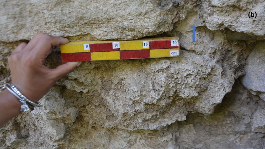
U. Chiocchini et al.
Ricerca Ambientale—Servizio Geologico d’Italia, in print-a). The color of the
rocks was defined by the Rock—Color Chart (Geological Society of America,
1991). 2) The execution of a) the partial cut of the weed and climbing vegetation
that covers many bridge structures; b) a first material survey by the Professional
BOSCH GLM 250 VF Laser Digital Distance Detector to define the current state
of the architectural and structural elements of the bridge; c) a second material
survey by a Laser Scanner Focus3D S to check in detail the dimensions of these
elements, and d) the aerial video shooting using the aircraft with remote con-
trolled pilot (drone models DJI Phantom 4 and Phantom 4 PRO). 3) The analy-
sis of the masonry textures of the original architectural and structural elements
and their construction techniques. 4) The acquisition of 15 samples of the mate-
rials used to build the bridge, 10 of which from the outcrops (alluvial pebbles,
phytoclastic travertine, sandstone, which was extracted by the HILTI electric
core drilling machine), 2 phytoclastic travertine samples from two arches of the
bridge and 3 samples of mortar from the latter and from a pier.
The following investigations were carried out in the third phase. 1) An electrical
resistivity tomography to define the thickness of alluvial deposits and the underly-
ing substrate, performed by the geo-resistivity-meter M.A.E. A6000SE, producing
the energization by means of electrodes driven into the ground with unit spacing
of 2 m and simultaneously acquiring the apparent resistivity (pa) and soil char-
geability (I.P.). The data recording was carried out according to the Dipole-
Dipole-Axial scheme, which allows to better read the lateral discontinuities, and
for the data processing the Res2Dinvi software was used. 2) A detailed inspec-
tion was carried out in the SVB area, located about 15 km north of the POB, to
verify the presence of remains attributable to a Roman age bridge.
The fourth phase was dedicated to the following laboratory analyses and tests
(Marra et al., 2015; Columbu et al., 2018; Sitzia, et al., 2020). 1) The mineralogical
analysis of the mortar by the X-ray powder diffractometer Siemens D5000 with
Gragg-Brentano and radiation λKαCu geometry, in which the crystalline powder
under examination is placed on a flat sample holder with a scan range of 2.5˚ <
2θ < 140˚. 2) The investigation of the samples of stone materials and mortar by
the polarized microscope Zeiss Axioskop on 30 µm thin sections. The modal
analysis of the mortar samples by point counter on 300 points for each thin sec-
tion. 3) The recognition of particular forms of calcite in the mortar by the FEI
Quanta-400 Scanning Electron Microscopy (SEM). 4) The tests to determine the
dry masses (md) at 105˚C ± 5˚C of the cubic samples (10 × 10 × 10 mm) of mor-
tar were carried out by the analytical balance Sartorius Entris153-1s. The real
volume (Vr) and bulk volume (Vb) were determined by the Regnault pycnometer
for solids with cap 100 ml. The bulk volume (Vb) was calculated as:
( mw − mh ) ρ w 25C × 100
Vb = (1)
where mw is the wet mass, mh is the hydrostatic mass of the wet sample, and
ρw25˚C is the density of the water (0.9970 g/cm3) at temperature of 25˚C. The ap-
DOI: 10.4236/ad.2021.94012 228 Archaeological Discovery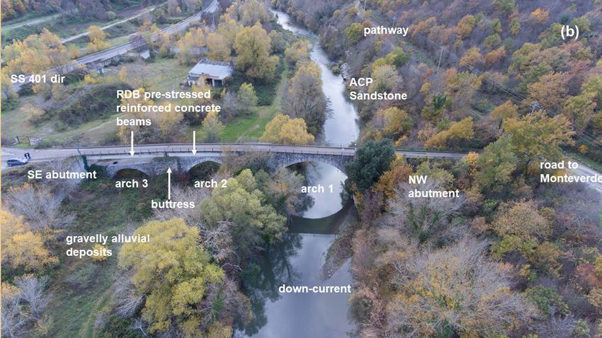
U. Chiocchini et al.

                             parent density (ρb) and the real density (ρr) were computed as:
                                                 =ρb m=
                                                      d Vb ; ρ r md Vr .                                       (2)

                                5) The preparation of four cores of ACP Sandstone for its mechanical charac-
                             terization according to the recommendations of ASTM (2014) and I.S.R.M.
                             (1994): verification of the perpendicular position of the base faces of cores with
                             respect to their axis; checking of the lateral surface of the cores which must be
                             smooth; measurement of the length and diameter of the cores as the average of
                             two diameters orthogonal to each other. 6) The execution of two uniaxial com-
                             pression tests and two tensile tests on the four cores by a Controls brand press
                             with controlled load.
                                As for the construction of Roman bridges, we refer to the monumental works
                             of O’Connor (1993) and Galliazzo (1995), which are still up today the most com-
                             prehensive, in-depth, and detailed ones (Cortéz Pérez et al., 2018; Inglese & Par-
                             is, 2020). In fact, these two Authors describe the historical, architectural, struc-
                             tural, archaeological, typological, and planning aspects (from the works of
                             foundation to the walking floor, the furnishings, the defenses) and methodology
                             on the possibility of dating, respectively, about 330 and 1560 bridges in different
                             areas of Europe and the Middle East. As for the architectural elements, reference
                             is made to the equally monumental work of Lugli (1957), still considered one of
                             the most complete and precise studies on this topic (Adams, 2011; Aveta et al.,
                             2012; Inglese & Paris, 2020). Finally, the study by Aveta et al. (2012) provided
                             valuable support for the conservation status and construction techniques of the
                             historic bridges in Campania.

                             4. Geological and Geomorphological Setting
                             The study area is located in the middle valley of the Ofanto River hosted in a tec-
                             tonic depression oriented west-east inside the Campania and Basilicata Apennine,
                             mainly consisting of clays, sands and conglomerates of the Pliocene Ruvo del
                             Monte Synthem, and subordinately of Mesozoic-Cenozoic formations (Figure 1
                             and Figure 2) (Sheet 450 S. Angelo dei Lombardi and Sheet 451 Melfi of the Geo-
                             logical Map of Italy at scale 1:50,000) (Istituto Superiore per la Protezione e la
                             Ricerca Ambientale—Servizio Geologico d’Italia, in print-a, in print-b). This area
                             is in contact with the western edge of the Mt. Vulture’s volcanic complex (Figure
                             2) with geochemical characteristics similar to those of the Campania Province (af-
                             finity with potassium and ultra-potassium series), active with pyroclastic depo-
                             sits and lava flows during middle Pleistocene between 0.740 and 0.140 Ma (Sheet
                             450 S. Angelo dei Lombardi and Sheet 451 Melfi of the Geological Map of Italy
                             at scale 1:50,000) (Istituto Superiore per la Protezione e la Ricerca Ambientale—
                             Servizio Geologico d’Italia, in print-a, in print-b). Figure 3 shows the geological
                             map of the bridge area in the section IV NO of the Sheet 187 Melfi at scale
                             1:25,000 of the Military Geographic Institute, and Figure 4 the corresponding
                             geological section. The stratigraphic succession includes the following formations
                             (Figure 3): the Cretaceous-lower Miocene Varicolored Clays Formation (red, green,

DOI: 10.4236/ad.2021.94012                        229                                    Archaeological Discovery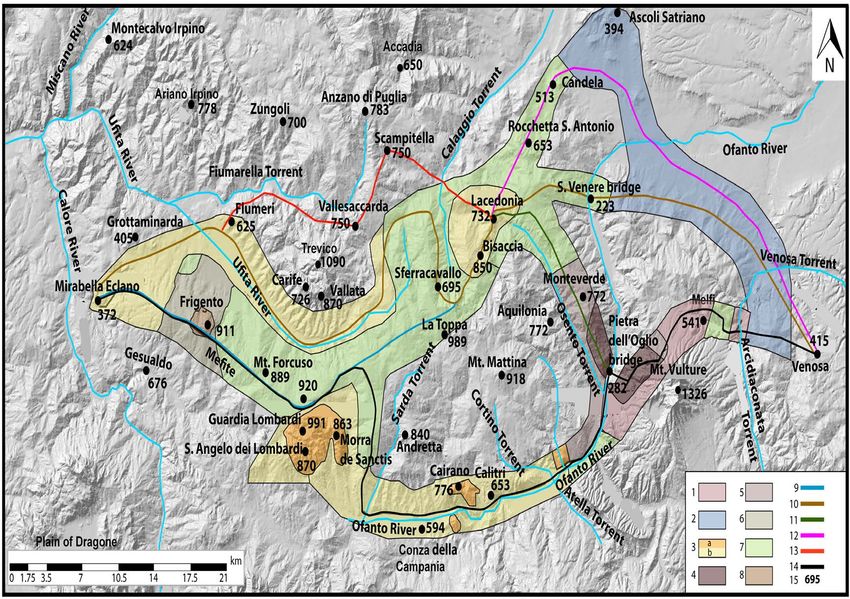
U. Chiocchini et al.

                             gray clays, marls, marly and siliceous limestones, turbidite calcarenites with chaotic
                             structure; AVR); the lower Miocene calcareous member of the AVR (turbidite
                             calcarenites and marls; AVR1); the lower Miocene Numidian Flysch (well ce-
                             mented turbidite medium-coarse quartz-arenites of dark yellow orange color 10
                             YR 6/6 with thick and very thick beds; FYN); the middle Miocene (middle-upper
                             Serravallian) Cerreta-Bosco di Pietra Palomba Sandstone (ACP). This is the most

                             Figure 3. Geological map of the area of the POB. The double dashed lines indicate the
                             unpaved secondary roads. a, slope deposits (Holocene); b, alluvial deposits (Holocene-
                             Actual); at, terraced alluvial deposits (upper Pleistocene-Holocene); TRV, terraced poly-
                             mictic gravels and phytoclastic travertines (middle-upper Pleistocene); DPI, pyroclastic
                             deposits (middle-upper Pleistocene); ACP, Cerreta-Bosco di Pietra Palomba Sandstone
                             (middle Miocene); FYN, Numidian Flysch (lower Miocene); AVR1, calcareous member of
                             the Varicolored Clays Formation (lower Miocene); AVR, Varicolored Clays Formation
                             (Cretaceous-lower Miocene); 1, normal fault; 2, bed attitude; 3, overturned bed; 4, landslide;
                             5, location of the samples for mineralogical, petrographic and strength analyses; 6, trace of
                             the geological section.

                             Figure 4. Geological section. b, alluvial deposits (Holocene-Actual); at, terraced alluvial
                             deposits (upper Pleistocene-Holocene); ACP, Cerreta-Bosco di Pietra Palomba Sandstone
                             (middle Miocene); FYN, Numidian Flysch (lower Miocene); AVR1, calcareous member of
                             the Varicolored Clays Formation (lower Miocene); AVR, Varicolored Clays Formation
                             (Cretaceous-lower Miocene); 1, normal fault.

DOI: 10.4236/ad.2021.94012                          230                                         Archaeological Discovery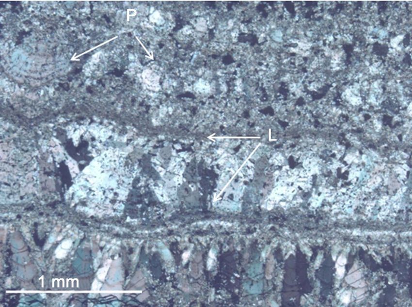
U. Chiocchini et al.

                             widespread formation, made up of turbidite medium-coarse sandstones of
                             dark yellow orange color 10 YR 6/6 with characteristic diagenetic spheroids
                             and thick and very thick amalgamated beds. These sandstones show a variable
                             medium degree of cementation in the rock mass. Furthermore, there are pyroc-
                             lastic and alluvial deposits. The former consists of juvenile ashes, ignimbrite de-
                             posits and polymictic heterometric sandy conglomerates with ash levels of the
                             middle-upper Pleistocene (DPI). The alluvial deposits include three units. 1) The
                             polymictic heterometric gravels and phytoclastic travertines (D’Argenio & Fer-
                             reri, 1987, 1988; D’Argenio et al., 2013) or calcareous tufa (Pedley, 1990, 2009,
                             2014; Ford & Pedley, 1996; Capezzuoli & Gandin, 2004; Gandin & Capezzuoli,
                             2008; Gandin, 2013; Capezzuoli et al., 2014; Imbriale, 2014) of white N 9 and
                             very light gray N 8 color, characterized by wavy and radiated structures, plant
                             fragments of encrusted macrophytes, porosity, and scarcely evident bedding
                             (TRV) of the middle-upper Pleistocene, that form a suspended terrace on the
                             current valley bottom. 2) The polymictic heterometric gravels with poor sandy
                             silty matrix, consisting of pebbles of marly and siliceous limestones, and calcare-
                             nites of light gray N 7 and dark gray N 3 - N 4 color with predominantly lamellar
                             and spheroidal shapes, referred to the upper Pleistocene-Holocene terraced de-
                             posits (at) of the actual valley bottom. 3) The Holocene-Actual similar deposits
                             (b) (Giannandrea, 2004; Istituto Superiore per la Protezione e la Ricerca Am-
                             bientale—Servizio Geologico d’Italia, in print-a). The electrical resistivity tomo-
                             graphy, performed on the alluvial deposits according to the 64 m long trace A -
                             B in Figure 5(a), highlighted 4 electro-layers (Figure 5(b)). The section of Fig-
                             ure 5(b) shows that the first layer, whose base is indicated by the wavy yellow
                             line, is characterized by resistivity values of 20 - 70 ohm and an average thick-
                             ness of 1.50 m. The second layer, delimited by the black line, has resistivity val-
                             ues of 100 - 600 ohm and an average thickness of 2 m. The third layer, whose
                             base is indicated by the line with white dots, shows resistivity values of 10 - 70
                             ohm and an average thickness of 6 m. The fourth layer is characterized by resis-
                             tivity values greater than 600 ohms. Therefore, the first and third layers are at-
                             tributed to gravels, the second layer to silty sands, the fourth layer to the ACP
                             Sandstone. Furthermore, the section of Figure 5(c) shows that the alluvial suc-
                             cession consisting of gravels-silty sands-gravels has a lenticular geometry and its
                             thickness at the top of the ACP Sandstone is less than 2 m in proximity and un-
                             der the arch 2.
                               The tectonic setting (Figure 3 and Figure 4) to the left of the Ofanto River
                             shows bed attitude of the ACP Sandstone dipping 20˚ - 45˚ towards SW and
                             overturned beds dipping SW 70˚, forming an inclined syncline with northeas-
                             tern vergence, while to the right of the river the bed attitude is dipping 20˚ - 35˚
                             towards SW forming gentle folds. The two structures to the left and right of the
                             river are in contact by a SW-NE oriented normal fault. A second NNW-SSE
                             oriented normal fault marks the contact between the ACP Sandstone and the
                             succession consisting of AVR - AVR1 - FYN (Figure 3 and Figure 4).

DOI: 10.4236/ad.2021.94012                        231                                    Archaeological Discovery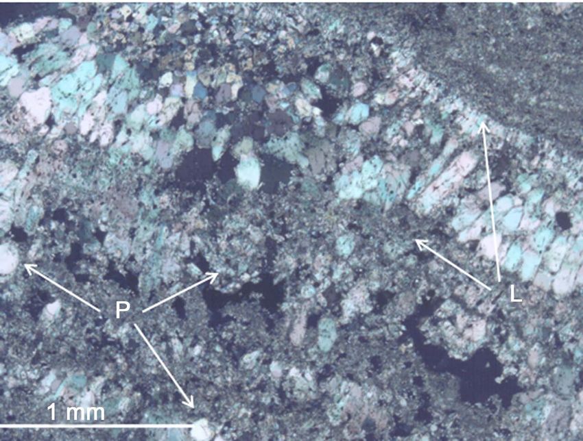
U. Chiocchini et al.

                             Figure 5. Location (a) and section (b) of the electrical resistivity tomography, and the re-
                             lated interpretation in lithological terms (c).

                               The section of the valley of the Ofanto River is about 50 m wide and the
                             slopes, free of landslides, are inclined 26˚ to the left and 10˚ - 20˚ to the right of
                             the river (Figure 4). In particular, it should be noted that the current incline
                             (20˚) of the right slope in the bridge area (Figure 4) decreased due the works of
                             excavation carried out on the ACP Sandstone for the construction of the nation-
                             al road SS 401 dir and its connection with the bridge.
                               In addition, the hydrogeological and seismic hazards of the study area are very
                             high (Ippolito & Paganelli, 1984; http://www.difesa.suolo.regione.campania.it/
                             Vallario, 2001). The former hazard is due to: 1) sometimes impressing landslides,
                             particularly in the very extensive areas characterized prevailingly by the Ruvo del
                             Monte Synthem and subordinately the Varicolored Clays Formation; 2) wide-
                             spread erosive phenomena caused by surface waters that are washed away and

DOI: 10.4236/ad.2021.94012                          232                                        Archaeological Discovery
U. Chiocchini et al.
channeled along the streams flowing with high gradients in the hydrographic
network of the Ofanto and Ufita rivers (Figure 1). The seismic hazard of Aqui-
lonia, in whose territory the POB is included, and Monteverde (Figure 2) is
classified in Zone 1, ie the most dangerous, characterized by acceleration index
(ag) > 0.25 with a probability of being exceeded equal to 10% in 50 years
(http://www.lavoripubblici.regione.campania.it/). The earthquakes of July 23,
1930, and November 23, 1980, with a magnitude, respectively, of 6.67 and 6.81
(https://www.ingv.it/), affected the Campania and Basilicata Apennine, causing
many deaths and damages to small towns and locally to some infrastructures.
Due to the earthquake of July 23, 1930, Aquilonia was rebuilt in an area about 2
km southwest.
5. Results
5.1. Historical Data from the Archives
The research at the Municipality of Aquilonia and Engineer of Avellino, that is
the public office that takes care of the maintenance of bridges and roads, re-
vealed that there is no documentation regarding the bridge in 1900.
Based on the indications of Massaro (1994), a dossier (Envelope 119) con-
taining administrative documents of the Ministry of Public Works relating to the
period 1856-1860 was examined at the State Archives of Napoli. In these docu-
ments, there is a concise reference to a project of the engineer Luigi Oberty
(1790-1874), who joined the Royal Corps of Engineers of Bridges and Roads at
the age of 19. In 1856 a request was made for the urgent repair of the POB. The
work proposal was examined in 1858 and 1859, when the project of the Inspec-
tor of the Department engineer Luigi Oberty was presented to the Provincial
Council of Principato Ultra. The Council deliberated that “without activating the
width of the bridge, it is enough to make each prospectus by the palm 1 and 1/2;
since it is a cart bridge the Inspector’s proposal shall be accepted to suppress the
upper part of the arches and instead, by repairing small arches, to study for a
flooring, to make a ground fill and to put the crushed stones above it”. This type
of works did not substantially change the original architectonic and structural
elements of the bridge, except the roadway.
5.2. The Current State of the POB
The small dimensions of the width of the valley (about 50 m) of the Ofanto River
with slopes consisting of the ACP Sandstone and free of landslides are the ideal
geomorphological conditions for building the bridge, which is of the masonry
type (pons lapideus), in fair condition of conservation, without breakages and
subsidence of the structures, and in operation with very little vehicular traffic. A
masonry bridge consists of main and secondary structural elements and archi-
tectural elements (Galliazzo, 1995; Hughes & Blackler, 1997; Gençer & Turan,
2017). To highlight the current state of the architectural and structural elements
(ASEs) of the POB and therefore to recognize which are original and which of
DOI: 10.4236/ad.2021.94012 233 Archaeological DiscoveryU. Chiocchini et al.
them were restored, modified, reconstructed, and, eventually, added for consolida-
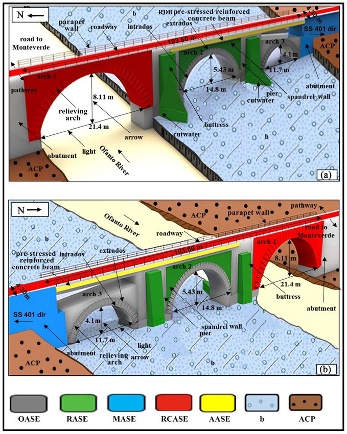
tion, we performed the material survey of the bridge (Figure 6 and Figure 7). This
survey showed that the main structural elements include the abutments, three
arches (1 on the river channel, 2, and 3 in Figure 6 and Figure 7) with semicir-
cular curvature to the intrados profile (round arch), already recognized by Le-
normant (1883) and De Lorenzo (1906), the spandrel walls, the piers, the foun-
dations, and the buttresses. The secondary structural elements consist of the
cutwaters and the relieving arches, and the architectonic elements include the
roadway and the parapet walls.
Abutments. These lie on the ACP Sandstone. The northwestern abutment is
original, made up of masonry in small apparatus with alluvial pebbles, while
the southeastern one was modified by the works carried out to allow the connec-
tion of the national road SS 401 dir to the bridge. The termination of the north-
western abutment is connected, in addition to the road to Monteverde, to the
Figure 6. Current state of the façade of the POB as seen through the drone up-stream
(southwest) in (a) and down-stream (northeast) in (b). The abutments, the arches 2 and 3
and the cutwaters are covered by weed and climbing vegetation. The pathway in (b) coin-
cides with the layout of the old Appian Way.
DOI: 10.4236/ad.2021.94012 234 Archaeological DiscoveryU. Chiocchini et al.
Figure 7. The 3D model illustrates the current state of the POB through the material
survey of its architectonic and structural elements (ASEs), seen up-stream in (a) and
down-stream in (b). OASEs (original: the northwestern abutment, the arches 2 and 3,
their relieving arches, the piers, the spandrel wall of the arch 3, the foundations); RASEs
(restored: the spandrel walls of the arch 2, the buttresses, the cutwaters); MASEs (mod-
ified: the southeastern abutment); RCASEs (reconstructed: the arch 1, the roadway, and
the parapet walls); AASEs (added: RDB pre-stressed reinforced concrete beams); (b) al-
luvial deposits; ACP, Cerreta-Bosco di Pietra Palomba Sandstone.
pathway with a straight trend (Figure 6(b)) that follows the layout of the old
Appian Way (Chiocchini et al., 2016). There is no trace of the fourth arch which,
according to Aveta et al. (2012), was covered due to the reconstruction of the
road to Monteverde.
Arch 1. It was reconstructed through the works probably carried out because
of the earthquakes of July 23, 1930 and November 23, 1980. The light is 21.4 m
long and the arrow 8.11 m. Arrow/light ratio = 0.38.
Arch 2. It is original. The light is 14.8 m long and the arrow 5.43 m. Ar-
DOI: 10.4236/ad.2021.94012 235 Archaeological DiscoveryU. Chiocchini et al.
row/light ratio = 0.37.
Arch 3. It is original. The light is 11.7 m long and the arrow 4.1 m. Arrow/
light ratio = 0.35.
The masonry of the face of arches 2 and 3 is in small apparatus including al-
luvial pebbles of marly and siliceous limestone with mainly blade shapes (Figure
8), some irregular ashlars of phytoclastic travertine with larger dimensions in the
upper part of the arches and rare fragments of bricks. The analysis of the maso-
nry texture and the construction technique of the face of arches 2 and 3, which
are an important basis for their dating, shows that the pebbles, the phytoclastic
travertine ashlars and the rare fragments of bricks are arranged lying in homo-
geneous courses with the tiled structure according to fairly regular beds (Figure
8), exactly as Vitruvio describes the construction technique in small apparatus of
the opus incertum (De Architectura II, VIII1).
Figure 8. Face of the arch 3, 4.30 m wide, showing the opus in-
certum, consisting of marly and siliceous limestone pebbles with
a blade shape and tiled structure, and the relieving arch with the
squared ashlars of phytoclastic travertine.
1
II, VIII. “There are two styles of walls: opus reticulatum, used today by everybody and the one
called opus incertum in use in ancient times. The former is more elegant, but prone to cracking be-
cause it has connections in every direction. On the other hand, in the opus incertum the stones lie
in courses on top of each other with tiled structure and have a less elegant but more solid structure
than the opus reticulatum. In both cases, however, it should be built with very small stones so that
the mortar-impregnated walls have longer durability.”
DOI: 10.4236/ad.2021.94012 236 Archaeological DiscoveryU. Chiocchini et al.
Spandrel walls. These are triangular parts of wall. Those of arch 2 were res-
tored, while those of arch 3 are original in small apparatus with pebbles and ash-
lars of phytoclastic travertine.
Piers. They have a rectangular base, are original and built by the opus qua-
dratum, including squared ashlars (average size of length 0.65 m, width 0.35 m,
thickness 0.25 m) of the phytoclastic travertine (Figure 9). The piers have a
thickness, corresponding to the long side of the base, between 4.35 m (arches 1
and 2) and 4.28 m (arch 3).
Buttresses. These are reinforcing piers with a rectangular base. At present
(Figure 6 and Figure 9) there are 6 restored on the sides of the arches both
up-current and down-current, built by the opus quadratum, consisting of
squared ashlars (average dimensions of length 0.50 m, width 0.24 m, thickness
0.20 m) of ACP Sandstones and phytoclastic travertine.
Foundations. Based on the geological survey (Figure 3 and Figure 4) and the
electrical resistivity tomography (Figure 5), which highlight the presence of the
ACP Sandstone under the alluvial deposits with a thickness of less than 2 m
(Figure 5(c)), it is reasonable to assume that there are four original foundations
of direct type resting on the ACP Sandstone.
Relieving arches. The four relieving arches of the arches 2 and 3 are original
and consist of masonry in small apparatus with squared ashlars of phytoclastic
travertine (Figure 8).
Cutwaters. These two defenses, covered by weed and climbing vegetation
(Figure 6(a)), have a pyramidal shape on a triangular base (Figure 7(a)) and are
Figure 9. The photo shows, on the left bank of the Ofanto River, the reconstructed arch 1
(RC), the original structures of the pier (PO), from which the sample PO 11 of mortar
highlighted by the arrow was collected, and, on the right, the base of the buttress (BO).
The middle upper part of the buttress is restored (R) mainly with squared ashlars of ACP
Sandstones and some pebbles of dark gray siliceous limestone. The vertical tube is part of
the hydrometric device.
DOI: 10.4236/ad.2021.94012 237 Archaeological DiscoveryU. Chiocchini et al.
restored with squared ashlars of phytoclastic travertine and a few ashlars of
marly limestones. The cutwater between arches 1 and 2 is integral, while the
cutwater between arches 2 and 3 has a lower height because the middle upper
part is demolished.
Roadway. The original one, 103.60 m long and 4.30 m wide, was also rebuilt
due to the works for the construction of the national road SS 401 dir.
Parapet walls. The current ones, which also include two sidewalks with a total
width of 0.48 m, are reconstructed. It can be assumed that the original parapets
had a width of 0.45 m with an outward projection, like in most Roman bridges
(O’Connor, 1993; Galliazzo, 1995).
Ratio pier thickness/arch light. According to Galliazzo (1995) in general this
ratio in modern masonry bridges is considered “good” if it is about 1/5 of the
light. The ratio values are about 1/3.4 for the arch 2 and 1/2.7 for the arch 3 of
the POB, like to the rather low values between 2/3 (or 1/2) and 1/4 of most of the
Roman masonry bridges. These values indicate that the piers guarantee complete
safety for the support of the arches.
The most significant and conspicuous modifications of the bridge involved
the following elements: 1) reconstruction of the arch 1; 2) insertion of four RDB
pre-stressed concrete beams (Figure 6), of which two, 20.5 m long, are raised
1.5 - 2 m with respect to the arch 3, while two, 18.4 m long, rest on the arch 2;
these elements are referred to as added ASEs (AASEs); 3) modification of the
southeastern abutment.
Thus, the bridge ASEs include two groups illustrated in the 3D model of the
bridge (Figure 7). The former group consists of 18 original ASEs built using the
techniques of opus quadratum and opus incertum (OASEs: the northwestern
abutment, the arches 2 and 3, four relieving arches, three piers, four spandrel
walls of the arch 3, four foundations). It should be noted that, based on the very
numerous macroscopic observations, the mortar of OASEs shows the following
uniform features: it is very hard; medium-fine grained; of very light gray N 8
color; the field tests with 10% hydrochloric acid suggest that it is always very rich
in calcite.
The latter group consists of 12 restored ASEs (RASEs: four spandrel walls of
the arch 2, six buttresses, two cutwaters), 1 modified ASE (MASE: the southeas-
tern abutment), 4 reconstructed ASEs (RCASEs: the arch 1, the roadway, and
two parapet walls), and 4 ASEs added for consolidation (AASE: four RDB
pre-stressed reinforced concrete beams). These restorations, modifications, re-
constructions, and additions are due to interventions carried out between the
early 1900s and today, largely for the construction of the national road SS 401
dir and its connection to the bridge, and as a consequence of the earthquakes of
July 23, 1930 and November 23, 1980. Furthermore, bearing in mind that the
average width of the distance between the wheels of the Roman wagons was
about 1.30 m (Galliazzo, 1995), the original roadway, 4.30 m wide including the
sidewalks (3.40 + 0.45 × 2), could allow the transit of wagons in two ways. Table
1 summarizes the data that characterize the bridge.
DOI: 10.4236/ad.2021.94012 238 Archaeological DiscoveryU. Chiocchini et al.
Table 1. Characteristic data of the Pietra dell’Oglio bridge.
Municipality of Aquilonia
Province of Avellino
Location Campania Region
Map of the Military Geographic Institute: Sheet 187 Melfi—Section IV
NO at scale 1:25,000
Type Masonry bridge on the Ofanto River
Road bridge that originally connected Monteverde only to its railway
Current use
station and later also to the national road SS 401 dir
II - I century BC. It is the Pons Aufidi of the Tabula Peutingeriana and is
Age and function referred to the layout of the old Appian Way between Mirabella Eclano
(Aeclanum) and Venosa (Venusia).
Conservation
Fair
status
There is no news about recent works at the Municipality of
Aquilonia and Engineer of Avellino. At the State Archive of Napoli
Historical news there is the documentation relating to some works on the bridge
decided by the Provincial Council of the Principato Ultra in 1858-1859.
These works do not have altered the original structure of the bridge.
Pebbles, phytoclastic travertine, Cerreta-Bosco di Pietra Palomba
Materials used for Sandstone (ACP), fragments of bricks. The mortar includes aggregates
the construction of quartz, K-feldspar, sandstone fragments and binder consisting of mi-
cro-spar, spar, and micrite.
Abutments
The northwestern abutment is original and consists of masonry with
pebbles. The southeastern one was modified by the works to connect the
bridge to the national road SS 401 dir.
Arches
The bridge consists of three roud arches. The arch 1 on the Ofanto River
is rebuilt. The arches 2 and 3 are original and with the face built by the
technique of the opus incertum. The dimensions of the light and arrow
decrease from the arch 1 to the arch 3.
Spandrel walls
Those of the arch 2 are restored, those of the arch 3 are original. The
masonry is built with pebbles and squared ashlars of phytoclastic
travertine.
Piers
They have a rectangular base, are original and built with the technique of
the opus quadratum.
Architectural and
Buttresses
structural
They have a rectangular base, are restored and built with the techniques of
elements (ASEs)
opus quadratum.
Foundations
They are original of direct type resting on the Cerreta-Bosco di Pietra
Palomba Sandstone (ACP).
Relieving arches
Those of the arches 2 and 3 are original and consist of squared ashlars of
phytoclastic travertine.
Cutwaters
They have a pyramidal shape on a triangular base and are restored.
Roadway
The original one is 103.60 m long and 4.30 m wide and is rebuilt.
Parapet walls
The current ones, which also include two sidewalks with an overall width
of 0.48 m, are rebuilt. The original ones were 0.45 m wide.
Ratio pier thickness/arch light
The values of the ratio are 1/3.4 for the arch 2 and 1/2.7 for the arch 3.
DOI: 10.4236/ad.2021.94012 239 Archaeological DiscoveryU. Chiocchini et al.
Continued
Original (OASEs)
The northwestern abutment, the arches 2 and 3, the relieving arches and
the piers of the arches 2 and 3, the spandrel wall of the arch 3, the direct
foundations.
Restored (RASEs)
The spandrel wall of the arch 2, the buttresses and the cutwaters.
Types of ASEs
Modified (MASEs)
The southeastern abutment.
Reconstructed (RCASEs)
The arch 1, the roadway, and the parapet walls.
Added (AASEs)
4 RDB pre-stressed reinforced concrete beams.
The arch 1 on the Ofanto River was rebuilt and four RDB pre-stressed
reinforced concrete beams were inserted between the southeastern
Main abutment and the arches 2 and 3 probably as a result of the earthquakes
interventions of July 23, 1930 and November 23, 1980.
The southeastern abutment was modified to connect the national
road SS 401 dir to the bridge.
5.3. Raw Materials Used for the Construction of the Bridge
5.3.1. Sampling
For the construction of the bridge OASEs, TRV phytoclastic travertine, ACP
Sandstone, “b” alluvial pebbles, rare fragments of bricks, and mortar were used.
The first three types of materials were also used for the restoration and recon-
struction of some architectural and structural elements. Therefore, in order to
define the mineralogical, petrographic, density and strength characteristics of
the materials used for the construction of the OASEs, the following 15 samples,
appointed by the acronyms PO and POS, were collected (Table 2).
• Four samples of phytoclastic travertine from the ashlars of the arch 2 (PO 1)
(Figure 10(a)) and arch 3 (PO 2) (Figure 10(b)) and for comparison from
the outcrops of TRV in the nearby area between Foggiano and the Ofanto
River (PO 3 and PO 4) (Figure 3) to be examined by petrographic analysis.
In this area the repeated anthropic interventions and the modelling processes
produced, for over 2000 years, substantial changes of the slightly steep slopes,
where it is not possible to recognize evident archaeological traces of excava-
tion on the surface for the mining of travertine.
• Six cores from the outcrop of the ACP Sandstone on the right side of the
Ofanto River, of which 2 (PO 5 and PO 6) for petrographic analysis and 4
(POS 1, POS 2, POS 3, POS 4) (Figure 3) to determine its strength.
• Two pebbles (PO 7, PO 8) of “b” alluvial deposits (Figure 3).
• Taking into account that the macroscopic characteristics of the mortar are
uniform, three samples of this material from the arch 2 (PO 9) (Figure
10(a)), arch 3 (PO 10) (Figure 10(b)) and the pier of arch 1 on the left bank
of the Ofanto River (PO 11) (Figure 9) for mineralogical and petrographic
analysis and density test.
DOI: 10.4236/ad.2021.94012 240 Archaeological DiscoveryU. Chiocchini et al.
Table 2. Distribution of samples (PO 3, PO 4, PO 5, PO 6, PO 7, PO 8) and cores (POS 1,
POS 2, POS 3, POS 4) collected from the outcrops and samples from the arch 2 (PO 1 and
PO 9), arch 3 (PO 2 and PO 10), and the pier of arch 1 (PO 11). b, alluvial deposits; TRV,
polymictic gravels and phytoclastic travertine; ACP, Cerreta-Bosco di Pietra Palomba Sand-
stone. Sampling location is shown in Figure 3 (PO 3 - 8; POS 1 - 4), Figure 9 (PO 11),
and Figure 10 (PO 1, 2, 9, 10).
Materials Formation Outcrop Arch 2 Arch 3 Pier of arch 1
Pebbles b PO 7, PO 8
Phytoclastic
TRV PO 3, PO 4 PO 1 PO 2
travertine
PO 5, PO 6, POS 1, POS 2,
Sandstone ACP
POS 3, POS 4
Mortar PO 9 PO 10 PO 11
Figure 10. The phytoclastic travertine ashlars, showing the characteristic pores, and the
mortar of arch 2 (a) and arch 3 (b), from which the samples PO 1 and PO 9, PO 2 and PO
10 were collected, respectively. The mortar is highlighted by arrow.
5.3.2. Petrographic Analysis of TRV Phytoclastic Travertine, ACP
Sandstone and “b” Alluvial Deposits
Samples PO 1, PO 2, PO 3, PO 4. The most common petrographic components
DOI: 10.4236/ad.2021.94012 241 Archaeological DiscoveryU. Chiocchini et al.
of TRV are micro-spar (calcite crystals between 5 and 15 mm) and micrite (cal-
cite crystals with diameter < 5 mm) with minor spar or pseudo-spar (calcite
crystals > 15 mm). Micrite and micro-spar frequently form laminated, peloidal,
aphanitic, and dendritic fabric (Figure 11 and Figure 12). The composition and
Figure 11. Photomicrograph of the sample PO 1 of phytoclas-
tic travertine collected from the ashlar of the arch 2 observed
under crossed nicols. The arrows indicate the laminar (L) and
peloidal (P) fabric.
Figure 12. Photomicrograph of the sample PO 3 of phytoclas-
tic travertine collected from the area between Foggiano and
the Ofanto River observed under crossed nicols. The arrows
indicate the laminar (L) and peloidal (P) fabric.
fabric suggest that the examined samples consist of the same type of TRV phy-
toclastic travertine or calcareous tufa (D’Argenio & Ferreri, 1988; D’Argenio et
al., 2013; Capezzuoli & Gandin, 2004; Gandin & Capezzuoli, 2008; Gandin, 2013;
Capezzuoli et al., 2014; Imbriale, 2014).
Samples PO 5, PO 6. The petrographic analysis of the ACP Sandstone shows
that the texture includes abundant coarse (0.73 - 1.10 mm) sub-angular and an-
DOI: 10.4236/ad.2021.94012 242 Archaeological DiscoveryU. Chiocchini et al.
gular grains, generally fractured, of monocrystalline and polycrystalline quartz,
K-feldspar (orthoclase and microcline) and plagioclase, and less frequent grains
of rock fragments (crystalline rocks and limestone) bounded by calcite cement
(Figure 13). In addition, there are also microfossils including large foraminifera
as Lepidocycline and Miogypsine (Figure 14), probably resedimented (see the
Figure 13. Photomicrograph of the sample PO 5 of arkose observed
under crossed nicols. The texture is made up of quartz (Qtz),
K-feldspar (Kfs), and plagioclase (Plg) bounded by calcite cement
(Cc). The plagioclase crystals are almost totally transformed in a fine
aggregate of white mica and calcite.
Figure 14. Photomicrograph of the sample PO 5 of arkose observed
under crossed nicols. The red circle highlights a Lepidocyclina sp.
Qtz, quartz.
items Resedimentation and Turbidity currents of American Geological Institute
(2005)), as occurs in the turbidite formations of different ages across the whole
Apennine chain (Consiglio Nazionale delle Ricerche, 1990; APAT, 2005).
Therefore, the ACP Sandstone has a quartz-feldspar composition of arkose type
DOI: 10.4236/ad.2021.94012 243 Archaeological DiscoveryU. Chiocchini et al.
(Schiattarella et al., in press).
Samples PO 7, PO 8. These pebble samples from the “b” alluvial deposits are
marly and siliceous mudstones rich in planktonic foraminifera, radiolarians,
generally turned in calcite, and sponge spicules.
5.3.3. Mineralogical and Petrographic Analysis of Mortar
Samples PO 9, PO 10, PO 11. The mineralogical analysis by X ray indicates that
the composition of the mortar is almost identical, including about 24% of quartz,
16% of K-feldspar, and 60% of calcite, as illustrated by the diffractogram of the
sample PO 9 in Figure 15. The modal percentage analysis in thin section (Table
3) shows that the mortar samples contain similar quantities of medium-fine ag-
gregates (0.20 - 0.125 mm), composed of quartz (arithmetic average 17.5%),
K-feldspar (arithmetic average 11.6%), sandstone fragments (arithmetic average
10.2%), and binder including micro-spar and spar (arithmetic average 36.8%),
and micrite (arithmetic average 23.8%) (Figure 16). Therefore, the mortar con-
sists of 60.7% of binder and 39.3% of aggregates and the binder/aggregate ratio
shows almost identical values (arithmetic average 1.5%) (Table 3). In addition,
the SEM analysis highlights the presence of a particular form of calcite consist-
ing of a fragment of microfossil (Figure 17).
Table 3. Modal percentage analysis of the aggregates and binder of the mortar samples.
B/A, binder/aggregate ratio. Aggregates: Qtz, quartz; Kfs, K-feldspar; Ss, sandstone frag-
ments. Binder: Cs, micro-spar and spar; Cm, micrite.
Total Total
Sample B/A Qtz Kfs Ss Cs Cm
aggregate binder
PO 9 1.5 18.2 11.1 10.2 37.4 23.1 39.5 60.5
PO 10 1.6 17.1 11.4 10.3 36.8 24.4 38.8 61.2
PO 11 1.5 17.2 12.3 10.1 36.3 24.1 39.6 60.4
Arithmetic
1.5 17.5 11.6 10.2 36.8 23.8 39.3 60.7
average
Standard
0.05 0.50 0.51 0.08 0.45 0.55 0.35 0.35
deviation
Figure 15. Diffractogram of the sample PO 9 of mortar.
DOI: 10.4236/ad.2021.94012 244 Archaeological DiscoveryU. Chiocchini et al.
Figure 16. Photomicrographs of the samples PO 9 (a), PO 10 (b), and PO 11 (c) of mor-
tar observed under crossed nicols. The texture includes aggregates of quartz (Qtz),
K-feldspar (Kfs), sandstone fragments (Ss), and binder consisting of spar and micro-spar
(Cs), and micrite (Cm).
DOI: 10.4236/ad.2021.94012 245 Archaeological DiscoveryU. Chiocchini et al.
Figure 17. SEM photomicrograph of the sample PO 9 of mortar. The red circle highlights
a microfossil fragment.
5.3.4. Mortar Density
The tests on the mortar samples provided values of real density (ρr) between 2.63
and 2.65 g/cm3 (arithmetic average 2.64 g/cm3) and of bulk density (ρb) between
1.37 and 1.40 g/cm3 (arithmetic average 1.39 g/cm3) (Table 4). These values are
consistent with the mineralogical composition of the mortar (Table 3).
Table 4. Values of the real density (ρr) and bulk density (ρb) of the mortar samples.
ρr ρb
Sample
(g/cm3) (g/cm3)
PO 9 2.65 1.40
PO 10 2.63 1.37
PO 11 2.64 1.39
Arithmetic average 2.04 1.38
Standard deviation 0.008 0.012
The results of the macroscopic and microscopic investigations on the mortar
suggest that it is characterized by a very homogeneous composition, and, for its
production, the lime was obtained (Karkanas, 2007; Stoops et al., 2017; Cortéz
Pérez et al., 2018; Montana et al., 2018) by calcination at about 1000˚C of the
TRV phytoclastic travertine (samples PO 3 and PO 4), while the sandy material
DOI: 10.4236/ad.2021.94012 246 Archaeological DiscoveryU. Chiocchini et al.
of the aggregates, due to the very limited availability of sand in alluvial deposits
(“at” and “b”; Figure 3), was obtained by grinding the ACP Sandstones (samples
PO 5 and PO 6). This mortar perfectly cemented the stone materials of the walls,
allowing the original architectural and structural elements of the bridge to still
be used actually.
5.3.5. Mechanical Properties of the ACP Sandstone
The uniaxial compression tests of the POS 1 and POS 2 sandstone cores and the
tensile tests of the POS 3 and POS 4 cores showed failure values ranging, respec-
tively, between 370.50 and 309.70 kg/cm2 (arithmetic average 340 kg/cm2) and
between 12.82 and 10.76 kg/cm2 (arithmetic average 11.79 kg/cm2) (Table 5).
These values suggest that the sandstone has a medium-high consistency (Tanzi-
ni, 2010) and, therefore, is a very good substrate for the bridge foundations.
Table 5. Mechanical characterization of the ACP Sandstone by uniaxial compression and
tensile tests.
Uniaxial compression test
Average Failure
Lenght Controlled Compressed Compressive
Core diameter stress
(cm) load (kg) area (cm2) strength (kg/cm2)
(cm) (kN)
POS 1 9.5 9.5 1630 70.85 262.7 370.50
POS 2 9.6 9.5 1640 70.85 219.4 309.70
Arithmetic
340.1
average
Standard
30.4
deviation
Tensile test
Length Average diameter Failure stress Tensile strength
Core
(cm) (cm) (kN) (kg/cm2)
POS 3 9.5 9.5 17.79 12.82
POS 4 9.5 9.5 15.68 10.76
Arithmetic
11.79
average
Standard
1.03
deviation
6. Discussion
The geological and geomorphological setting, the historical data from the arc-
hives, the description of the current state of the POB, and the materials used for
its construction suggest the following main topics as crucial points for the POB
origin: 1) the construction techniques of Roman bridges in Campania; 2) the
modifications of architectural and structural elements of the bridge over time; 3)
the dating of the bridge; 4) the presence of remains attributable to a Roman age
bridge in the area of the SVB, in relation to the layout of the old Appian Way.
DOI: 10.4236/ad.2021.94012 247 Archaeological DiscoveryU. Chiocchini et al.
6.1. Construction Techniques of Roman Bridges in Campania
Galliazzo (1995) proposes to classify Roman bridges also based on materials and
construction techniques, indicating the Italic type characterized by face with
opus quadratum and internal structure with masonry work, the Valdostan type
with an arch or twin arches, the Severian type which is an updated version of the
first type, and the Campanian type built with masonry and face in small appara-
tus including opus testaceum and/or opus mixtum with alternating brick beds
and opus reticulatum beds, and ornamental complement of opus vittatum or
vittatum mixtum. This Author recognizes in the province of Avellino the pres-
ence of the Roman bridges of Casalbore (Santo Spirito and Ponticello), Luogo-
sano and San Sossio Baronia. According to Aveta et al. (2012) the face of the
Roman bridges of Campania is often built by the opus testaceum (bricks), opus
mixtum, opus vittatum and vittatum mixtum.
Therefore, in addition to what is indicated by Galliazzo (1995) and Aveta et al.
(2012), the material survey suggests that for the construction of the POB on the
Ofanto River in the province of Avellino in Campania were also used the tech-
niques of the opus quadratum and opus incertum.
6.2. Modifications of the Architectural and Structural Elements
of the Bridge over Time
The only works documented and carried out on the bridge are those approved
by the Provincial Council of Principato Ultra in 1856-1860. These works have
not substantially modified the original structure of the bridge. Moreover, further
restoration, modification, reconstruction and consolidation works were carried
out for the construction of the national road SS 401 dir and its connection to the
bridge, and as a consequence of the earthquakes of July 23, 1930 and November
23, 1980. Unfortunately, there is no documentation of these works. Therefore,
the conditions of the architectural and structural elements of the bridge prior to
the current ones (Figure 6 and Figure 7) are documented only by the photos of
De Lorenzo (1906), Guarini (1909), Gardner Collection (Castrianni, 2013), Bug-
lione (1929), Iacobone (1935). The clearest photos are those of the early 1990s by
De Lorenzo (1906) (Figure 18(a)) and Gardner Collection (Castrianni, 2013)
(Figure 18(b)), which show the bridge in its substantial integrity: the longitu-
dinal profile of the bridge is characterized by an asymmetrical curvilinear trend
with a slight slope towards both sides of the Ofanto River. Therefore, it is possi-
ble to compare the conditions of the architectural and structural elements of the
bridge in the photos of De Lorenzo (1906) (Figure 18(a)) and the Gardner Col-
lection (Castrianni, 2013) (Figure 18(b)) with those of today (Figure 6) in order
to highlight the changes that took place between the early 1900s and the present
time. The photo of De Lorenzo (1906) (Figure 18(a)) shows “the ancient Pietra
dell’Olio Bridge on the Ofanto River near Aquilonia”, taken from the left bank of
the Ofanto River (NW, down-stream) with gravelly alluvial deposits. The struc-
ture of the bridge appears with the arches 1 and 2, the buttresses and the north-
DOI: 10.4236/ad.2021.94012 248 Archaeological DiscoveryYou can also read