Hawke's Bay Trends THE STATE OF OUR ENVIRONMENT - May 2020 - Hawke's Bay Regional Council
←
→
Page content transcription
If your browser does not render page correctly, please read the page content below
Hawke’s Bay Trends
THE STATE OF OUR ENVIRONMENT
May 2020
May 2020
Given another sixteen hours, May’s report would have been significantly rosier.

Instead, most of May’s measures were left hanging on the desperate end of below normal. The latter half of the
month did at least see a climb to 70% of May’s average rainfall. It wasn’t accompanied by any significant rise in the
month’s river levels and it wasn’t sufficient to hoist soil moisture far from the floor it’s adhered to for quite some
time. Groundwater levels continued in red territory as they did the previous month.

Things have since improved but that’s a story for another month, assuming the cracking start to June isn’t all flash
in the pan. While May rainfall was a whisker away from being a good news story, air quality shaved perilously close
to being a bad news story.

We avoided a PM10 exceedance in Hastings with an uncomfortable squirm and it’s one measure where less is
definitely more.

Kathleen Kozyniak
Principal Scientist - Climate and Air
SUMMARY May 2020

Still dry, by a whisker, and autumnal temperatures.

This is a summary of the regions rainfall, river flows,
ground water, air quality and soil moisture levels.
Data and images provided by HBRC.

June to August Forecast.
Temperature Near or above average
Rain           Below normal
River flows    Near or below normal
Soil moisture Near or below normal
     source : NIWA

For more information
www.hbrc.govt.nz
P: 06 835 9200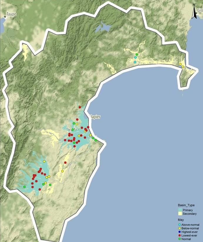
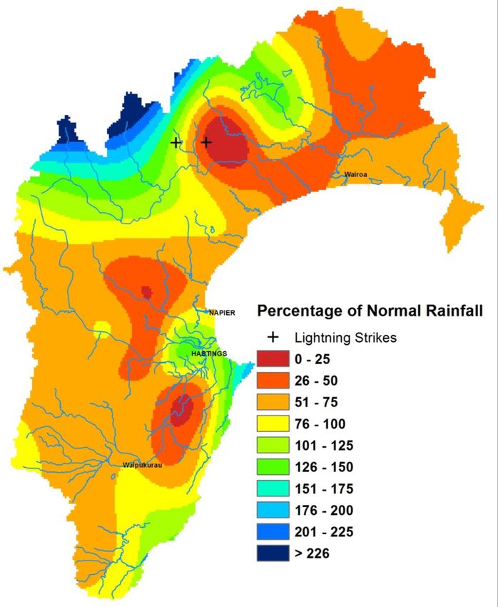
RAINFALL

Below normal. The seventh consecutive month for
some areas. Two cloud to ground lightning strikes.

Lightning counts come from the Blitzortung.org
lightning network to which HBRC contributes.

Percentage of normal May rainfall
(30 year average)

For areas in the region:
Waikaremoana                         86%
Northern HB                          51%
Tangoio                              64%
Kaweka                               63%
Ruahine                              68%
Heretaunga Plains                    72%
Ruataniwha Plains                    62%
Southern HB                          85%
Hawke’s Bay Region                   69%
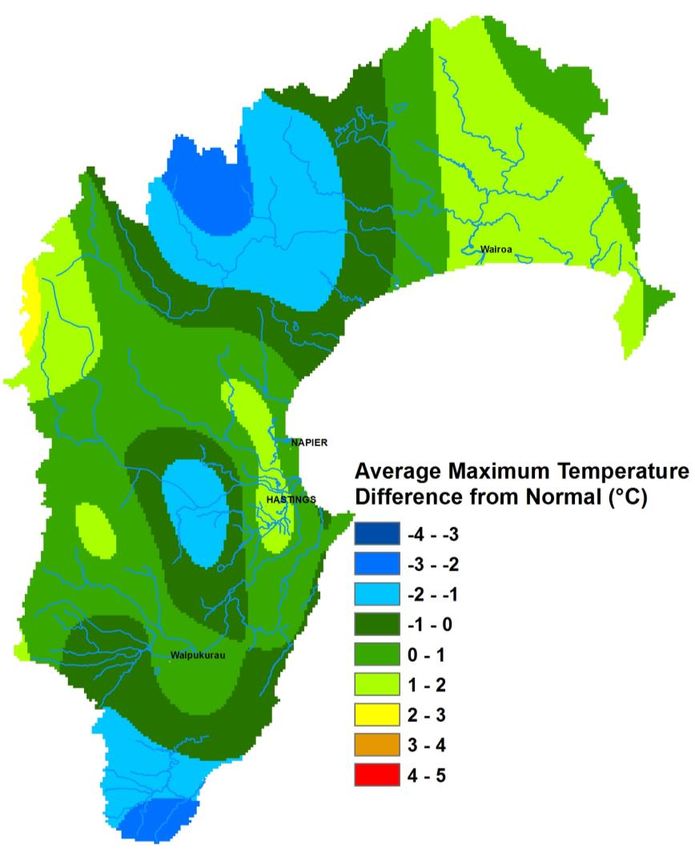
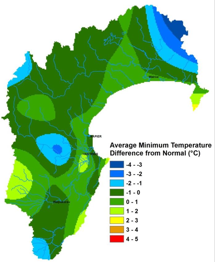
TEMPERATURES
Average for late autumn.

Mean Difference from Normal
Maximum Temperature: 0.3 °C
Minimum Temperature: 0.01 °C

Mean Daily Maximum: 15 °C
Mean Daily Minimum: 6 °C
Highest Daily: 25.5°C
Location: Wairoa North Clyde EWS
Lowest Daily: -8.1 °C
Location: Taharua
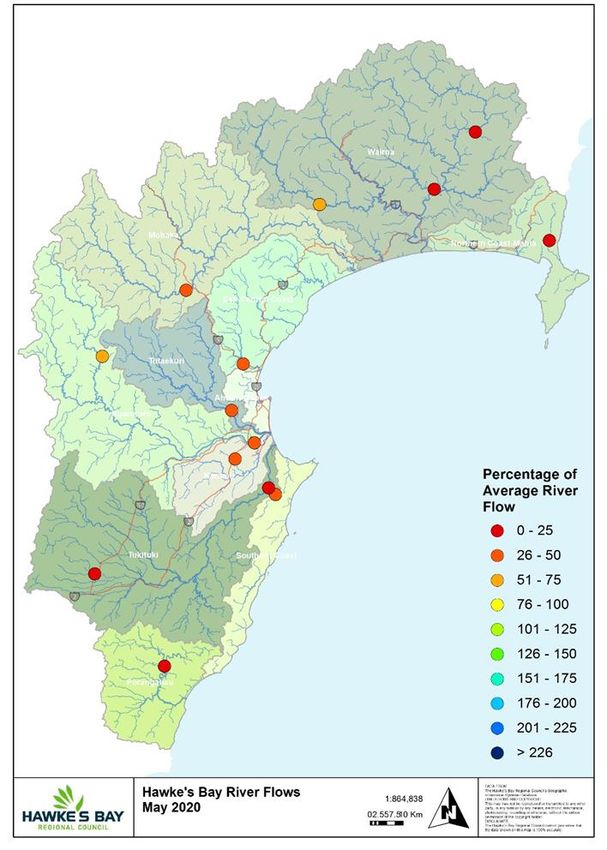
RIVER FLOW
Percentage of average May flows
for areas in the region:

Northern Coast – Mahia            20%
Northern HB – Hangaroa River      13%
Northern HB – Wairoa River        18%
Northern HB – Waiau River         58%
Mohaka                            43%
Esk-Central Coast                 39%
Tūtaekuri                         26%
Karamu                            35%
Ngaruroro – Kuripapango           55%
Ngaruroro – Chesterhope           30%
Southern Coast                    42%
Tukituki – Tukipo River           13%
Tukituki – Tukituki River         16%
Porangahau                         0%
Hawke’s Bay Region                29%

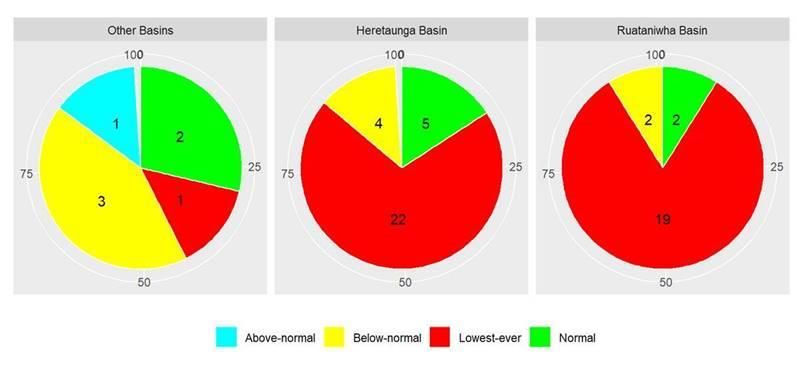
GROUNDWATER & SOIL MOISTURE

Soil Moisture: Below normal except in northern areas.
Current state of Groundwater levels:
This report compares groundwater levels in May with historic readings to
evaluate current conditions.

To assess these conditions, we have grouped groundwater levels at each well
relative to their monthly percentiles.

Groundwater levels measuring between their monthly minimum and 25th
percentile are considered below-normal, groundwater levels measuring between
the 25th and 75th percentiles are classed as normal, and groundwater levels
measuring between the 75th-maximum are considered above-normal.
Wells with less than 5 years of record are excluded from the analysis.
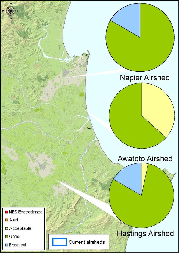
AIR QUALITY

A pass mark… just. No exceedances.

Figure 1: PM10 levels in the Napier, Hastings and
Awatoto airsheds during May 2020.

PM10 exceedances:
The National Environmental Standard (NES) for
particulate matter (PM10) of 50 micrograms per cubic
metre (24 hour average) was not exceeded in the
Napier, Hastings and Awatoto airsheds in May2020.

The monitoring sites are located at:
Marewa Park in the Napier airshed.
St Johns College in the Hastings airshed.
Waitangi Road in the Awatoto airshed.

Further information is available at www.hbrc.govt.nz

LONGER FORECAST

The neutral mode of the El Niño-Southern Oscillation is still in force but it looks like it will battle with La
Niña for supremacy as we head into spring and summer. That’s encouraging in terms of rainfall for those
seasons.

In the meantime we have to get through a winter that is looking less encouraging. Higher than normal
pressure over northern New Zealand is the main pattern with a westerly flow the main outcome.

That is giving a dry look to the east coast for the three months but the same westerly flow should keep
temperatures near or above average.

Kathleen Kozyniak
Principal Scientist - Climate and Air
You can also read