Inundation and sediment dispersion on a natural floodplain along the Rio Beni, Bolivian Amazon - Graie
←
→
Page content transcription
If your browser does not render page correctly, please read the page content below
I.S.RIVERS 2018

               Inundation and sediment dispersion on a natural
               floodplain along the Rio Beni, Bolivian Amazon
               Inondation et dispersion des sédiments dans une plaine
               inondable naturelle le long du Rio Beni, en Amazonie
               Bolivienne

               A. C. Schwendel1, R. Aalto2, S. Buckley2, A. P. Nicholas2
               1School of Humanities, religion and Philosophy, York St John University, York,
               YO31 7EX, UK
               2College of Life and Environmental Sciences, University of Exeter, Exeter, EX4

               4RJ, UK

RÉSUMÉ
La stratigraphie et le fonctionnement hydro-écologique des plaines inondables naturelles sont
conditionnés par des processus érosifs et sédimentaires, prenant en compte l'érosion des berges, la
sédimentation sur les berges lors des crues et le comblement des méandres abandonnés. La forte
hétérogénéité spatiale des dépôts en termes de taille et d'âge des grains, et les schémas de
végétation et de topographie, cette dernière souvent masquée par de vastes forêts, constituent un
contexte difficile pour la modélisation de l'inondation et du dépôt des sédiments en suspension.
Cependant, la pression croissante exercée sur ces plaines inondables par l'agriculture et les
installations humaines exige des informations détaillées afin de guider ces développements. Cette
étude présente un modèle hydraulique qui permet de simuler l'étendue et la profondeur de l'inondation
ainsi que la concentration de sédiments en suspension dans le bassin versant du très dynamique Rio
Beni en Amazonie Bolivienne pendant une saison des inondations. Les résultats du modèle s’ajustent
bien avec l'étendue de l'inondation dérivée de l'imagerie satellitaire durant la saison des crues de
2011, et pourrait être utilisé dans des études à long terme sur l'évolution des plaines inondables
lorsque la migration des méandres est prise en compte.

ABSTRACT
Stratigraphy and hydro-ecological functioning of natural floodplains are conditioned by erosional and
sedimentary processes, including bank erosion, overbank sedimentation during floods and the fill of
abandoned meanders. The high spatial heterogeneity of deposits in terms of grain size and age, and
the resulting vegetation patterns and topography, the latter often masked by extensive forests, are a
challenging environment for the modelling of inundation and dispersion of suspended sediment.
However, the increasing pressure on these floodplains from agriculture and settlement require detailed
information in order to guide these developments. This study presents an hydraulic model that allows
the simulation of the extent and depth of inundation as well as the suspendend sediment
concentration in the foreland basin of the highly dynamic Rio Beni in the Bolivian Amazon during a
flood season. The model compares well with the extent of inundation derived from satellite imagery
during the 2011 flood season and has potential to be used in long-term studies of floodplain evolution
when meander migration is taken into account.

KEYWORDS
floodplain sedimentation, hydraulic model, inundation model, overbank flow, sediment dispersion

                                                  1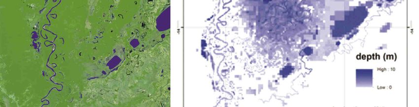
I.S.RIVERS 2018
1 EXTENDED ABSTRACT
The evolution of natural floodplains is a function of sedimentary processes such as the infill of
abandoned channels, formation of splays and overbank sedimentation, and erosional processes. The
latter include erosion on the floodplain by overland flows and bank erosion driven by meander bend
migration. However, these types of processes are not decoupled from each other and cannot be
considered in isolation. Infill of abandoned channels and overbank sedimentation create a complex
floodplain stratigraphy with spatial variation in deposit age, grain size and organic carbon content. This
heterogeneity in deposit characteristics leads to spatial variability in resistance to bank erosion and
hydraulic connectivity between channel and floodplain which influences channel migration and thus
planform development (Schwendel et al., 2015; Lewin et al., 2017)). The interaction between erosion
and deposition is also a key control on channel capacity, flood conveyance and avulsion.
Understanding the spatial distribution of these deposit properties and the feedback on channel
migration is a key to understanding floodplain evolution which, in the long-term has implications for the
development of hydrocarbon reservoirs and channel belt avulsion. In the shorter term it provides
insights into channel planform development, channel avulsion and ecological functioning of the river-
floodplain complex. An improved understanding of floodplain evolution also facilitates prediction of
flood frequency, extent of floodplain inundation and distribution of sediment and associated carbon,
nutrients and pollutants on the floodplain.
Floodplains are a preferential setting for human settlements for various reasons, including suitable
topography, nutrient-rich soils, supply of water and food, and river navigation. As such even the
remotest floodplains have been settled by humans for millennia. However, with increasing population
figures and technological advances the population pressure on quasi-unmodified floodplains has
increased dramatically in recent decades. This study draws on the example of the Rio Beni in the
Bolivian Amazon (Fig. 1a) where numerous villages have been set up along the river in the last 30
years and increasing area of floodplain is converted from forest to farmland. The success of these
ventures is affected by flooding and channel migration which has forced sudden relocation of
settlements and abandonment of previously cleared farmland. Understanding the interplay between
floodplain sedimentation and channel migration may allow avoidance of inconvenience to humans and
the preservation of some of the ecological functioning of the river-floodplain complex by guiding future
development.
This study investigates channel migration patterns of the meandering, sand-bed Rio Beni (Fig. 1a) and
relates them to floodplain sedimentation, in particular the deposition of suspended sediment during
floods and the infill of abandoned channels. Overbank deposition, and channel migration are assessed
at a meander bend scale and inundation and sediments dispersal are modelled for the entire foreland
basin. Planform geometry is analysed over a 55 year period based on GIS analysis of aerial and
satellite imagery (Schwendel et al., 2015). The spatial distribution, extent and age of overbank
sediments were assessed at 18 meander bends and throughout the foreland basin from soil cores
which underwent 210Pb chronology. This allowed the calculation of sedimentation rates and the
detection of episodical or continuous deposition. These shallow depth cores were complemented at
one bend by three electrical resistivity transects that allowed characterisation of stratigraphy and grain
size across a point bar and an abandoned channel. This information was fed into a combined 1D and
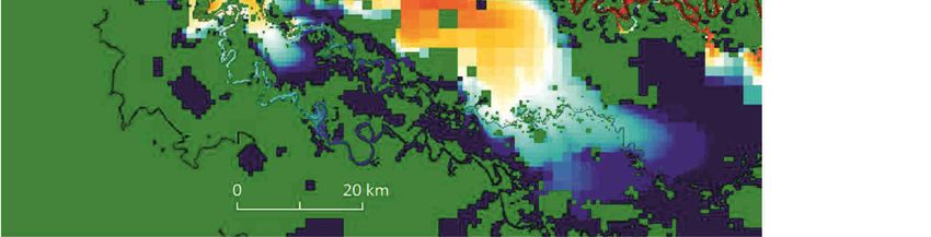
2D hydraulic model which uses a finite volume approach to solve the shallow water equations in order
to simulate floodplain inundation (Fig. 1b). It includes the effect of local precipitation as this is an
important influence on floodplain hydraulics at the Rio Beni (Aalto et al., 2003). This model was
coupled with an advection diffusion model to predict dispersal of sand, silt and clay fractions across
the floodplain (Fig. 1c). The inundation model exhibited a high level of maximal fit compared to
inundation extent derived from satellite imagery.
LIST OF REFERENCES
Aalto, R., Maurice-Bourgoin, L., Dunne, T., Montgomery, D.R., Nittrouer, C.A. and Guyot, J.L. (2003). Episodic
sediment accumulation on Amazonian flood plains influenced by El Nino/Southern Oscillation. Nature, 425,
493-497.
Lewin, J., Ashworth, P.J. and Strick, R.J.P. (2017). Spillage sedimentation on large river floodplains. Earth
Surface Processes and Landforms, 42(2), 290-305.
Schwendel, A.C., Nicholas, A.P., Aalto, R.E., Sambrook Smith, G.H. and Buckley, S. (2015). Interaction between
meander dynamics and floodplain heterogeneity in a large tropical sand-bed river: the Rio Beni, Bolivian
Amazon. Earth Surface Processes and Landforms, 40, 2026-2040.
2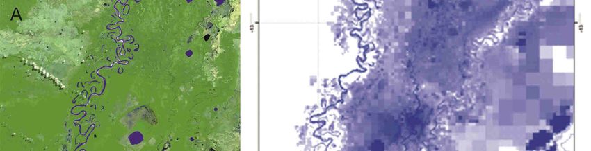
I.S.RIVERS 2018
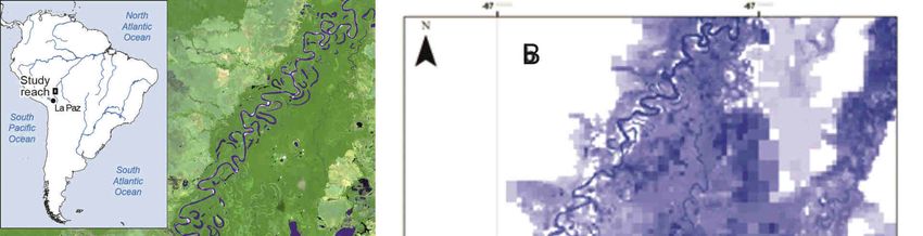
Figure 1. Study reach of the Rio Beni (A), simulation of inundation extent and depth on the receding limb of a
flood (B) and modelled sediment dispersion on day 55 of a 6 month wet season hydrograph (C).
3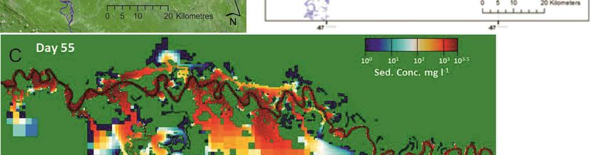
You can also read