Journal of Hydrology: Regional Studies - horizon ird
←
→
Page content transcription
If your browser does not render page correctly, please read the page content below
Journal of Hydrology: Regional Studies 34 (2021) 100791
Contents lists available at ScienceDirect
Journal of Hydrology: Regional Studies
journal homepage: www.elsevier.com/locate/ejrh
Hydrochemical and isotopic characteristics of groundwater in the
Continental Intercalaire aquifer system: Insights from Mzab Ridge
and surrounding regions, North of the Algerian Sahara
Youcef Hakimi a, *, Philippe Orban a, Pierre Deschamps b, Serge Brouyere a
a
University of Liège, ArGEnCo, Urban and Environmental Engineering, GEO3, Hydrogeology and Environmental Geology, Belgium
b
Aix Marseille Univ, CNRS, IRD, INRAE, Coll France, CEREGE, Aix-en-Provence, France
A R T I C L E I N F O A B S T R A C T
Keywords: Study region: North of Sahara, Algeria.
North Western Sahara Aquifer System Study focus: The effects of water/rock interactions and hydrodynamic conditions on the charac
Continental Intercalaire aquifer teristics of groundwater in the Continental Intercalaire aquifer (CI) are demonstrated using
Mzab Ridge
hydrochemical and isotopic data from the Mzab Ridge.
Hydrogeochemistry
Water stable isotopes
New hydrological insights: The results confirm that CI groundwater in the oriental basin is highly
SOM mineralized (1010 > EC > 3500 μS/cm) and is of the SO4-Cl-Na type. However, it is poorly
mineralized (340 > EC > 960) in the occidental basin and predominantly belongs to the HCO3-Ca
type. The important contribution of evaporite minerals has been deduced using saturation indices
and minor element ratios of Sr/Ca and Br/Cl. This is explained by lithological heterogeneities
within the CI aquifer and corroborates the observations from regional piezometric features which
suggest a groundwater divide located between 31.55◦ and 31.57 ◦ N latitude. δ18O-NO3 and δ15N-
NO3 analyses show that NO3 has a predominantly natural origin, which is soil nitrification even
for the high concentrations exceeding 50 mg/L. CI groundwaters are highly depleted in both δ18O
and δ2H compared to modern rainfall isotopic signatures. The most depleted ones are those sit
uated in the Great Oriental Erg sub-basin. Isotopic values as low as δ18O=− 6‰ can be taken as
the limit for groundwater that is typically old. In the El Golea region, isotopic enrichment seems
to indicate mixing between old groundwater and evaporation-affected groundwater infiltrating
through the dunes of the Great Occidental Erg.
1. Introduction
The North-Western Sahara Aquifer System (NWSAS) is one of the largest transboundary aquifer (TBA) systems and the second in
size in the world after the Nubian Sandstone (IGRAC, 2015). Shared between Algeria, Tunisia, and Libya, the NWSAS covers an area of
more than 1 million km2 (OSS, 2003). Important groundwater reserves of this multilayer aquifer, estimated to be 31 000 ⨯ 109 m3
(Baba Sy, 2005), are divided into two aquifers: the lower Continental Intercalaire (CI) and the upper Complexe Terminal (CT) (Castany,
1982). Excessive groundwater mining from these aquifers, mainly for irrigated oasis agriculture, has led to a general piezometric head
decline, as well as groundwater quality degradation (OSS, 2003). In many parts of the aquifer system, groundwater shows high
* Corresponding author.
E-mail addresses: hydro.yhakimi@gmail.com, ghyoucef.hkm@gmail.com (Y. Hakimi), p.orban@uliege.be (P. Orban), deschamps@cerege.fr
(P. Deschamps), serge.brouyere@uliege.be (S. Brouyere).
https://doi.org/10.1016/j.ejrh.2021.100791
Received 1 September 2020; Received in revised form 7 February 2021; Accepted 9 February 2021
Available online 20 February 2021
2214-5818/© 2021 The Authors. Published by Elsevier B.V. This is an open access article under the CC BY-NC-ND license
(http://creativecommons.org/licenses/by-nc-nd/4.0/).
Y. Hakimi et al.                                                                               Journal of Hydrology: Regional Studies 34 (2021) 100791

salinities, above the quality guidelines for domestic or irrigation uses.
    Because of its strategic importance for the remote semi-arid and arid areas of Algeria, Tunisia, and Libya, a transboundary
cooperation through the Sahara and Sahel Observatory (OSS) was launched between these countries in the mid-90 s (Nijsten et al.,
2018). Several scientific programmes have been developed to improve the understanding of the hydrologic functions of the NWSAS
and provide sustainable management scenarios of this resource (Besbes et al., 2003; OSS, 2003; UNESCO, 1972).
    One of the pivotal parameters to be defined for sustainability analysis is the estimation of the groundwater budget of the system, in
particular, the recharge rates of the CT and CI aquifers. For the NWSAS, several approaches have been used to assess the recharge
(including rate, localization, and mean residence time), such as hydrogeological modelling (Baba Sy, 2005; Baba Sy et al., 2007;
Gonçalvès et al., 2020; Zammouri and Ribeiro, 2017), geophysical approaches based on satellite-based gravity data (Gonçalvès et al.,
2013, 2020), and geochemical and isotopic approaches (Darling et al., 2018; Gonçalvès et al., 2015; Gonfiantini et al., 1974; Guendouz
and Michelot, 2006; Matsumoto et al., 2020; Petersen et al., 2013, 2018; Trabelsi et al., 2009).
    The identification of geochemical processes affecting groundwater chemistry and quality is also pivotal to the elaboration of a
sustainable water resource management programme, particularly in areas where high salinities are observed. Several studies have
focused on processes controlling the mineralization of groundwater, either of the CT or the CI aquifers, mainly in Algeria and Tunisia
(Abdelali et al., 2020; Abid et al., 2009, 2010, 2012a, 2012b; Ben Alaya et al., 2014; Edmunds et al., 2003; Elliot et al., 2014; Guendouz
et al., 2003; Hadj Ammar et al., 2014, 2020; Moulla and Guendouz, 2003; Moulla et al., 2012; Zammouri et al., 2007). Multiple studies
have shown that the hydrogeochemical signatures (chemical and isotopic) and residence times of groundwater in these aquifer systems
significantly differ (lithology, geometry and tectonic) (Edmunds et al., 2003; Guendouz, 1985; Guendouz and Michelot, 2006; Hadj
Ammar et al., 2014; Moulla et al., 2012; Petersen et al., 2018).
    Although all these studies cover a significant part of the NWSAS, the region that extends between the Great Occidental and Oriental
Erg sub-basins (Fig. 1) has received much less attention than the south-western part of the Great Occidental Erg sub-basin or the Great
Oriental Erg sub-basin. However, this region is important in the global functioning of these aquifers because it corresponds to the Mzab
Ridge (see geomorphological units in Fig. 1), which marks the groundwater divide between these sub-basins (Baba Sy, 2005). In
addition, the CI is the principal water resource in Ghardaia and El Golea regions (Achour, 2013), which during the last decades, has
become a preferred area for intensive agricultural investments.
    By combining geochemical and isotopic methods, the objective is to identify processes governing the hydrochemistry of CI
groundwater and explain the spatial variations in groundwater quality in the Mzab Ridge and surrounding regions. Here, we present
major elemental analyses to describe dominant geochemical processes, stable isotopic analyses (δ18O and δ2H) to discuss the origin of
groundwater, and NO3 stable isotope analyses to identify the sources of high nitrate concentration in CI groundwaters. For the sake of
obtaining a complete overview of the CI groundwater characteristics in the north of Algerian Sahara, available data from Edmunds
et al. (2003); Moulla et al. (2012) and Darling et al. (2018) were also combined with groundwater chemistry and isotopic data collected
in the studied area. Finally, in the scope of our investigations, the implementation of a multivariate statistical analysis using the
Self-Organizing Maps (SOMs) method is targeted (Kohonen, 1995; Peeters et al., 2007).

Fig. 1. Main geomorphological units of Algerian Sahara (Chabour et al., 2018) and the whole extension of the CI aquifer. Cross-sections show the
geological characteristics in the study area. A-A’ cross-section shows the tectonic transition between the Saharan Atlas and Saharan Platform
(modified after Chettih, 1995). B-B’ shows the variations of CI lithology and its depth and thickness across the Mzab Ridge.

                                                                       2
Y. Hakimi et al. Journal of Hydrology: Regional Studies 34 (2021) 100791
2. Geographical, geological, and hydrogeological contexts of the study area
The study area is located between 2.8◦ and 6.1 ◦ E longitude and between 30.1◦ and 33.1 ◦ N latitude in the north of the Algerian
Sahara between the towns of Ghardaia and El Golea (Fig. 1). It covers the Mzab Ridge and partially the basins located on either side, the
Great Occidental and Oriental Ergs. Temperatures range between a minimum of − 5 ◦ C in January and a maximum of 50 ◦ C in July.
Annual rainfall is less than 65 mm, on average (FAO CLIMWAT, 2006), and the rainfall is very irregularly distributed between months
and years.
From a geological point of view, the study area is located northwest of the “Saharan Platform” domain, which extends over the
Algerian Sahara and corresponds to thick Phanerozoic sub-horizontal and quasi-monotonic sedimentary formations (1000–8000 m)
(Askri et al., 1995; Fabre et al., 2005).
The “Continental Intercalaire” term was introduced for the first time by Kilian (1931). The meaning has evolved throughout
history. Currently, it designates the Lower Cretaceous shaly-sand and sandstone formations (from Barremian to Albian) wrapped by
clay formations of the Upper Jurassic below and Upper Cretaceous above. These clastic deposits are continuous over the whole basin
(Figs. 1 and 2), from the Saharan Atlas in the north to the Tinrhert Plateau in the south and further to the Tassili mountains of the
Hoggar and, west to east, from the Guir-Saoura valley in western Algeria to the Libyan desert (Edmunds et al., 2003; Moulla et al.,
2012; OSS, 2003). It has a thickness of 350 m in average, varying from 0 m in its southern border to 1000 m under the Oriental Erg and
towards Southern Tunisia (OSS, 2003).
The A-A’ cross-section in Fig. 1 (modified from Chettih, 1995) shows that the “South Atlas Flexure” separates the CI layers
outcropping in the Saharan Atlas from their equivalent in the Saharan Platform in the south where CI layers are buried at great depths
(Askri et al., 1995). So, hydraulic continuity between these two parts of the CI aquifer is unexpected (OSS, 2003).
The B-B’ cross-section in Fig. 1 is situated within the study area, which is a part of the Saharan Platform. It was obtained by a simple
interpolation between the geological data given in Busson (1970) completed by geophysical logging (UNESCO, 1972) in the same
boreholes. Piezometric heads for year 2000 were given in the SASS project (OSS, 2003). From a lithological point of view, hetero
geneities can be observed within the CI aquifer. In the south (El Golea), it is mainly composed of detrital materials and sandstones
sometimes cemented by carbonate minerals. However, it is clay-rich in the northwest (Ghardaia, Guerrara). Towards the northeast
(Touggourt), the lithology progressively changes to limestone but, in the study area, limestone deposits are not so important compared
to the rest of the Eastern Algerian Sahara (Busson, 1970). In the Great Oriental Erg sub-basin, Busson (1970) reported that the Albian
layers contain gypsum and anhydrite in various forms (cement, fine crystallized intercalations etc.).
The first regional piezometric map was established during the ERESS project conducted by UNESCO in 1972, and then it was
updated in 2000 as part of the SASS project accomplished by the OSS in 2003. The latter was added as background for most of our
figures. It shows that the main recharge area of the CI aquifer is the Saharan Atlas in the Great Occidental Erg sub-basin (Baba Sy,
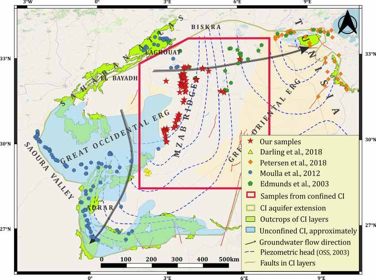
Fig. 2. Sample locations of the present survey and those of previous works. The Mzab Ridge corresponds to the central part and the transition zone
between the Great Occidental and Oriental Erg sub-basins.
3
Y. Hakimi et al.                                                                            Journal of Hydrology: Regional Studies 34 (2021) 100791

2005), which is the origin of two groundwater flow directions. In the Great Oriental Erg sub-basin, groundwater flows from the west to
the east until Gabes Gulf in Tunisia and, in the Great Occidental Erg sub-basin, from north to south and southwest until Adrar region.
Baba Sy (2005) showed that the CI aquifer is partially unconfined in the Great Occidental Erg sub-basin and shallow towards the
southwest (Fig. 2), where it is one of the discharge areas. The CI aquifer is confined in the other areas of its extension over the Algerian
Sahara and South Tunisia. The equipotential lines are almost orthogonal to the outcrops of CI layers in the Saharan Atlas in the north
(Laghouat and Biskra regions), which means that there is no ongoing flux through the northern limit of the CI aquifer as discussed in
the B-B’ cross-section (Fig. 1).
    Transmissivity values range from 10 to 40 × 10− 3 m2/s in El Golea region south and from 3 to 5 × 10− 3 m2/s in Ghardaia, Ouargla
and El Oued regions north (UNESCO, 1972). This is reflected by the hydraulic gradient which is bigger in the north (piezometric curves
are closer). In addition, the hydrochemistry of the CI groundwater is significantly affected by this variation in the lithology. This is
discussed below.
    The lithological variations and their impact on hydrochemical characteristics of groundwater have led to the definition of “useful
reservoir” (B-B’ cross-section in Fig. 1). It corresponds to the parts of the CI aquifer where sandstones and shaly sandstone strata are
dominating (-50 % of shale) and contain fresh groundwater (dry residue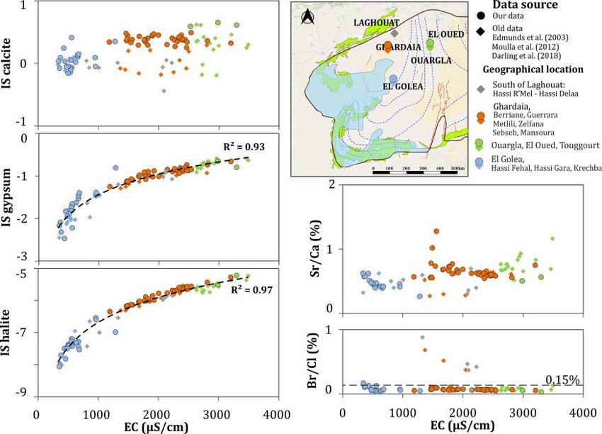
Y. Hakimi et al. Journal of Hydrology: Regional Studies 34 (2021) 100791
supplementary material. The oriental group contained 72 samples and the occidental group contained 28.
EC ranges from 340 to 960 μS/cm for samples belonging to the occidental group and from 1010 to 3500 μS/cm for the oriental
group (Fig. 3). Temperature values range between 25–34 ◦ C and between 25–56 ◦ C, respectively. As can be seen for both parameters,
the values are lower in the occidental group than in the oriental one. The central region (Hassi Fehal) is characterized with inter
mediate values for both parameters.
Fig. 3 shows increasing temperature and EC along the WE transect, which was also demonstrated by Edmunds et al. (2003). The
electrical conductivity increases along the main groundwater flow directions. The in situ temperature increases with depth (see B-B’
cross-section in Fig. 1).
For the oriental group, Ca concentrations range from 80 to 280 mg/L, Mg from 25 to 100 mg/L, Na from 15 to 630 mg/L and K from
2 to 50 mg/L. Regarding anions, HCO3 concentrations range from 100 to 250 mg/L, SO4 from 80 to 1000 mg/L, Cl from 65 to 650 mg/
L. For the occidental group, Ca, Mg, Na and K range from 30, 5, 25, and 5 mg/L to 80, 85, 115 and 15 mg/L, respectively. HCO3, SO4,
and Cl range from 80, 30, and 10 mg/L to 240, 200, and 140 mg/L (Fig. 4).
In El Golea region, the EC ranges around 450 ± 100 μS/cm. However, the EC of the sample Hg02 is 1300 μS/cm. It is characterized
by the highest concentrations for all ions compared to other samples in El Golea. This can be seen in the box plot of the occidental group
where the maxima values, which represent Hg02 characteristics, are much bigger than the 3rd quartile. In addition, Hg02 is situated
close to the El Golea Lake. This probably indicates that there are some leaks in this well from the shallow aquifer draining the
evaporated water from the lake. For instance, NO3 exceeds the WHO standard guideline for drinking water fixed at 50 mg/L (WHO,
2017).
Fig. 3 presents the spatial repartition of chemical type according to the degree of mineralization using a Stiff diagram (Stiff, 1951).
There are two main water types: for the oriental group, the samples can be characterized as SO4-Cl-Na type, and for the occidental
group, they predominantly belong to the HCO3-SO4-Cl-Ca type.
In order to better describe the interaction between groundwater and the geological matrix, there are multiple approaches allowing
a better understanding of the origin of mineralization and even to deduce which minerals are present in the aquifer. The most common
are saturation indices (SI), as defined by Alley (1993) and Plummer et al. (1976).
The SI values range from − 8.1 to − 5.2 for halite, from − 2.5 to − 0.6 for gypsum (anhydrite in same range), and from − 0.4 to 0.6 for
calcite (aragonite in same range). Therefore, the CI groundwater is undersaturated with respect to halite and gypsum and in equi
librium with respect to calcite (Fig. 5). It can also be observed that SI values of the occidental group (El Golea) are smaller than those
reported in the oriental group (Ghardaia, Ouargla and El Oued) for all minerals.
The new data shows clearly the variations in hydrochemical characteristics of CI groundwater between both sides of the Mzab
Ridge. This difference is due to either lithological characteristics of the aquifer and/or to residence time and groundwater age. As
explained in “Section 2”, the CI aquifer is more sand-enriched, so more conductive, in El Golea region.
Such low values of saturation indices for halite and gypsum seem to indicate their absence in the geological matrix. However, the
logarithmic tendency curve of their SI’s are strongly correlated with EC (R2>0.9, SI is calculated with logarithmic equation). Actually,
Tellam (1995) has calculated SI for saline groundwater in Permo-Triassic sandstone aquifer. He found that in samples with gypsum and
halite SI’s equal to − 0.5 and − 1, respectively, SO4 and Cl concentrations were approximately 3600 and 10,000 mg/L, respectively.
Clearly, extremely high concentrations are necessary to approach equilibrium with respect to gypsum and halite. Thus, we deduce that
Fig. 3. Spatial evolution of physical parameters and chemical water type of the CI groundwater. In (A), the symbol size is referring to in situ-
temperature and the colour scale is based on the electrical conductivity. In (B), the water type is showed using Stiff diagram which allows well
visualizing of dominant ions and the mineralization.
5
Y. Hakimi et al.                                                                                  Journal of Hydrology: Regional Studies 34 (2021) 100791

Fig. 4. Concentrations of major elements and their variation in CI groundwater in the confined area of the CI aquifer. Variabilities between the
oriental and the occidental groups are much contrasted.

Fig. 5. Saturation indices for the main minerals. Anhydrite is in the same range as gypsum and aragonite is in same range as calcite. Sr/Ca and Br/Cl
ratios are calculated using meq/L concentrations. The map shows spatial localization of samples. The samples collected during this survey are
represented with dots. The diamonds are those from the old studies. This symbology is employed in the next figures.

the existence of evaporitic minerals in the CI aquifer can be supposed even in small proportion.
   Those results show the major contribution of evaporitic minerals in CI groundwater mineralization all over its extension but their
concentrations in groundwater are diluted. However, the bicarbonate type in El Golea region can be explained by the interaction of CI
groundwater with the calcite cement of sandstone.
   To verify this hypothesis, molar ratios using minor elements such as strontium and bromide are widely used in the literature to
deduce the aquifer lithology (Alcalá and Custodio, 2008; Ben Alaya et al., 2014; Bouchaou et al., 2008; Hem, 1985; Herczeg et al.,
1991; Négrel and Petelet-Giraud, 2005; Ouhamdouch et al., 2017).
   Sr/Ca ratios range from 0.2 to 2.5 % (Fig. 5). According to Edmunds et al. (2003), this ratio is almost constant in the Great Oriental
Erg sub-basin which should imply the dissolution of gypsum. This is in good agreement with the aforementioned geological data.
   In addition, bromide is a good conservative anion behaving similarly as chloride. Most of the samples have a Br/Cl ratio less than
0.15 % (Fig. 5), which is the lower limit for seawater salinization (Herczeg and Edmunds, 2000). So, CI groundwater salinity is derived
from dissolution of continental halite that is contained in the aquifer.

                                                                         6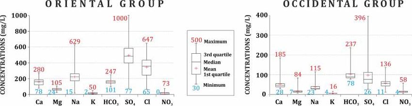
Y. Hakimi et al. Journal of Hydrology: Regional Studies 34 (2021) 100791
4.2. Stable isotopes of water molecule
Stable isotopes of the water molecule (δ18O vs δ2H) are presented in Fig. 6. The isotopic composition of CI groundwater in Algeria
and Tunisia ranges from -9.2 to -2.3‰ for δ18O and from -69.2 to -34.8‰ for δ2H. Most of the samples from the CI aquifer lay below
both the GMWL of Craig (Craig, 1961) and Sfax local meteoric lines (South Tunisia) defined by Maliki et al. (2000) and Abid et al.
(2009), the closest dataset for rainwater available in the literature. The scatter plot of CI groundwater situated inside of the SASS basin
in Algeria follows the trendline δ2H ¼ 3.01 δ18O - 36.70 showing that the CI groundwater has undergone evaporative processes. In
addition, the samples from bordering regions (Saharan Atlas and Saoura Valley) follow the trendline δ2H ¼ 3.07 δ18O - 31.39.
Groundwater from the confined and unconfined CI aquifer show different behaviours. On the one hand, groundwater from the
confined part (except for the samples from south of El Golea) are the most depleted (δ18O < -6‰), while δ18O for groundwater from the
unconfined part of the aquifer is more variable (from -8 to -2.5‰).
Despite the big distances separating samples from the confined CI situated in the Great Oriental Erg sub-basin, their isotopic
composition is more homogeneous than that from the unconfined CI situated in the Great Occidental Erg sub-basin. This has been
reported since the first studies on the stable isotope composition of the CI groundwaters (Conrad and Fontes, 1970; Gonfiantini et al.,
1974). They concluded that more variability in isotopic composition induces more variation in groundwater origins and recharge
conditions and vice versa. Gonfiantini et al. (1974) and Edmunds et al. (2003) confirmed that CI isotopic composition under the Great
Oriental Erg sub-basin is the initial signature of an old recharge because the CI groundwater there is protected from the external input
or evaporation.
Using tritium content, Moulla et al. (2012) highlight the existence of modern recharge in Saoura Valley shallow aquifer, which
shows also an evaporative signature. Moreover, Gonfiantini et al. (1974) and Edmunds et al. (2003) showed, that CI groundwater
contains around 55 pmc of 14C in Gourara region and the Saharan Atlas, successively, where the CI layers are unconfined. These
activities indicate the ingoing of relatively modern recharge in those regions. So, the trendline equation “δ2H ¼ 3.07δ18O - 31.39”,
which includes the samples from the unconfined aquifer, should represent modern Saharan groundwater.
In addition, the CI groundwater isotopic signature is significantly depleted relative to weighted mean modern rainfall in Sahara
(δ18O = − 5.1‰, δ2H = − 26‰) calculated by Edmunds et al. (2003). So, the CI groundwater cannot be in any way derived from the
actual rainfall as concluded by Darling et al. (2018). According to Rozanski et al. (1993), these depleted values seem to indicate that CI
groundwaters were infiltrated under a cooler and/or wetter climate regime than today. This is in agreement with recharge temper
atures calculated by Guendouz et al. (1997) using noble gases, which were 2–3 ◦ C cooler than the present mean annual temperature of
21 ◦ C. Moreover, several studies have showed that the most important recharge occurred during the Late Pleistocene when the
paleoclimate in the North Sahara and Sahel regions was wetter than today (e.g., Beyerle et al., 2003; Edmunds, 2009).
Knowing that the CI aquifer under the Great Occidental Erg sub-basin is unconfined and sometimes covered by pervious layers of
Mio-Plio-Quaternary (almost dunes), the samples from El Golea region should be more exposed to evaporation and more enriched in
stable isotopes. This corroborates with the work of Gonfiantini et al. (1974) who concluded that CI groundwaters in the Great
Occidental Erg sub-basin indicate “an evaporation mechanism, probably peculiar to the dune systems, which gives rise to
heavy-isotope enrichment compared with the recharge of other types of formations.”
Fig. 6. Isotopic composition (δ2H vs δ18O) of CI groundwaters. Data from the unconfined CI are also plotted. The isotopic composition of CI in South
Tunisia after Petersen et al. (2018) is represented by the grey triangle for comparison.
7Y. Hakimi et al. Journal of Hydrology: Regional Studies 34 (2021) 100791
However, samples situated downgradient in the south of El Golea region (Hassi Gara and Krechba), where CI is confined, are the
most enriched samples of all over the confined CI (δ18O > − 6‰). These groundwaters could be the result of a mixture between old
groundwater and recently evaporated water. Another possible explanation is that the recharge area for CI in El Golea region is different
between the north (El Golea city) and the south (Hassi Gara and Krechba).
In summary, end-members of the scatter plot correspond to the most depleted samples from the confined CI under the Great
Oriental Erg (Ouargla, El Oued) and the most enriched samples from the occidental basin (Gourara region).
Finally, Edmunds et al. (2003) concluded that there is no correlation between δ18O and δ2H of CI groundwater and its age in the
Great Oriental Erg sub-basin. However, this global vision demonstrates that there is an isotopic depletion that is proportional to the
distance from the recharge area and thus to the age of groundwater. The most enriched groundwaters are situated in the Great
Occidental Erg sub-basin, where CI is partially unconfined.
To verify the hypotheses and the conclusions of this section, it is likely that the use of radioactive isotopes and noble gases would
provide more clarification. It is the next step of our research project.
4.3. Multivariate analysis with a self-organizing map (SOM)
The self-organizing map (SOM) technique is an artificial neural network (ANN) algorithm based on unsupervised learning. It is a
powerful tool for exploring and clustering large and multivariate datasets (Kohonen, 1995). This technique has been widely applied is
various fields of groundwater quality (e.g., Hong and Rosen, 2001; Jurado et al., 2018; Tobiszewski et al., 2012).
The main objective of SOM is to reduce the dimensionality of datasets for easier visualization of their variability. First, all samples
are normalized and introduced as “input vectors”, and then the algorithm runs an iterative “training process” to join each sample to one
“node” of the artificially created network corresponding to “output vectors”. The “Euclidean distance” between these two vectors
should be as small as possible. Unlike ordinary multivariate statistical techniques, SOM is able to consider non-linear relationships
between variables and run with missing data. As a result, the SOM produces two kinds of outputs: (1) A “U-matrix” showing the
observation’s position and defining clusters using K-mean clustering methods, where the number is chosen by the user. The closer the
two individuals are, the more they look alike. (2) The 2D “component planes” showing the values of each variable, according to the
precedent matrix. The observation of the component planes allows deductive relationships and correlations between variables, based
on their similarities or dissimilarities (Peeters et al., 2007).
We chose the SOM technique to discuss two phenomena (Fig. 7). (i) First, defining redox conditions at the captive part of the CI
aquifer using results of the available indicators of these processes, namely, NO3 and Fe + Mn. (ii) In addition, we included other
susceptible variables to explain the evolution of fluoride concentrations in CI groundwater.
A distribution of the samples into two distinct groups (oriental and occidental) was clearly shown by the U matrix. The “OCD”
cluster groups the samples belonging to the Great Occidental Erg sub-basin. In addition, a set of clusters “OR1-4” includes the samples
belonging to the Great Oriental Erg sub-basin with an arrangement according to the direction of flow mentioned by the arrows.
The component matrix shows that δ18O of the CI groundwater is inversely correlated with the electrical conductivities (ECs). As
demonstrated in the previous section, the enrichment of δ18O is inversely correlated with the residence time as well as with EC.
Samples from the occidental cluster (OCD) are the most enriched and the less mineralized.
NO3 concentrations range between 3 and 75 mg/L for OCD, OR1, OR2, and OR3 clusters, and they are less than 1 mg/L in OR4
cluster. It can be noticed that they significantly decrease downgradient. The component matrix shows that Fe + Mn is inversely
correlated with NO3. These elements have the highest concentrations in the downgradient OR4 cluster. This corresponds to residence
time and the predominance of reduced conditions downgradient of the confined CI. Actually, after consuming of NO3 by denitrifi
cation, Fe and Mn become the terminal electron acceptors, they are reduced and solubilized in groundwater (Appelo and Postma,
Fig. 7. SOM results for samples belonging to the confined CI. On the right, the U-matrix defines the clusters: four clusters from the oriental group
“OR1-4′′ and one cluster from the occidental group “OCD”. On the left, the component planes show the variables and explain the correlations
between them. The samples’ names indicate their geographical locations.
8Y. Hakimi et al. Journal of Hydrology: Regional Studies 34 (2021) 100791
2005). This is in agreement with the results of Edmunds et al. (2003) who showed that even if the oxidizing conditions dominate in the
captive part of the CI south of Laghouat (RD samples) and approximately on the whole region of Ghardaia (samples: BR, GR, GD and
ZF), they begin reducing in the east of the sub-basin of Grand Erg Oriental (samples: TG, OG and OD).
It can be noted that NO3 concentrations are higher upgradient of the oriental clusters “OR1-2” than the occidental clusters “OCD”
that are also characterized by a depletion in δ18O. The previous section had already concluded that the palaeoclimatic conditions of the
CI recharge were wetter and colder in the Great Oriental Erg sub-basin than in the Great Occidental Erg. In a similar context, Edmunds
and Gaye (1997) studying high nitrate concentrations in groundwater in the Sahel countries, concluded: "There is also evidence that
high ratios relate to wetter and low values to more arid climatic periods".
Another phenomenon is the decrease in fluoride concentrations downgradient from 1.4 to 0.4 mg/L within the clusters of the
oriental clusters “OR1-4”. Paradoxically, this decrease is not accompanied by an increase in the saturation index of fluorite, the main
mineral controlling its concentration in water. This would thus indicate an evolution towards the precipitation of this mineral. In
contrast, there was a decrease from -0.6 to -1.7, which implies a tendency towards dissolution if the mineral would have been present.
Moreover, in the literature, fluoride mobility is considered a "pH-dependent" process. The fixation of F following anionic exchange
induces the release of OH, which would increase the pH. Paradoxically, for the oriental clusters, a decrease in pH can be observed
downgradient with a decrease in F concentrations. Thus, the hypothesis of anionic F/OH change as a cause of decrease in F levels can
be excluded.
The negative correlation of the F with δ18O is also observable in our dataset. This reinforces the hypothesis of Edmunds et al. (2003)
that F contents are influenced by palaeoclimatic conditions during recharge. Samples located upgradient of the oriental clusters (OR1
and OR2) were exposed to more intense evaporation than those located downgradient (OR4). On the other hand, the lowest levels were
observed in the occidental cluster (OCD), whereas the stable isotope data show that these waters are the most evaporated. According to
Edmunds and Smedley (2013), these concentrations are specific to the rainfall signature and their variations are related to evaporation.
4.4. Nitrate origin
Fig. 8 shows that δ15N-NO3 ranges from -1.9‰ to 9.5‰ and that δ18O-NO3 ranges from 2.6‰ to 12.6‰, except for three samples,
Hg03, Gr01 and Og02 (Fig. 8). Based on the classification of Mayer (2005), which is an updated version of that of Kendall (1998), such
low values reflect soil nitrification processes, a natural origin of NO3, although reported concentrations are high.
Og01 and Tg01 samples contain less than 0.3 mg/L of NO3, which is not enough to analyse the NO3 isotopes. They are situated
downgradient, northeast of the study area, in the reducing zone according to Edmunds et al. (2003). Therefore, such low concen
trations can be explained by an ongoing denitrification process of reaction.
Until now, many studies have reported high values of NO3 in the sandstone aquifers of arid zones in Australia (Barnes et al., 1992),
in Sahelian countries (Edmunds and Gaye, 1997) and in the Kalahari Desert (Heaton et al., 1983; Stadler et al., 2008, 2012). They
concluded by using different methods that nitrates originate from natural sources. Some studies have also proven that soil can contain
naturally high values of NO3 in arid zones (Schwiede et al., 2005; Stone and Edmunds, 2014; Walvoord et al., 2003).
Gr01 and Og02 samples were strongly enriched in both δ15N-NO3 and δ18O-NO3. Knowing that their NO3 concentrations are 2.7
and 3.9 mg/L, respectively, and they are situated downgradient, close to Og01 and Tg01, their positions in the plot show that they are
situated in the denitrification trajectory.
Sample Hg03 was strongly enriched in δ18O-NO3, with isotope signatures close to NO3 derived from synthetic nitrate-containing
fertilizers. The sampled borehole was located on agricultural land and was used for irrigation, where pollution may have occurred.
The position of sample Hg02 in the boxes representing the origin of NO3 (with respect to the isotopic composition) confirms that its
high mineralization is due to a mixing with natural evaporated water that does not originate from polluted groundwater.
The oriental group is more enriched in NO3 isotopes than the occidental group. This is most likely to be due to partial denitrification
Fig. 8. Identification of NO3 origin using the classification of Mayer (2005).
9Y. Hakimi et al. Journal of Hydrology: Regional Studies 34 (2021) 100791
occurring in this part of the study area or to differences in recharge conditions.
5. Conclusions
This paper fills the gap in the knowledge of Continental Intercalaire aquifer hydrogeochemistry on both sides of the Mzab Ridge
immediate vicinity.
It can be concluded that groundwater in the confined area of the CI aquifer under the Mzab Ridge and the Great Oriental Erg sub-
basin behaves differently than that in the unconfined zone in the Great Occidental Erg sub-basin. In the first area, the characteristics
are primarily controlled by water-rock interactions that involve residence time, but in the second zone, some external factors disturb
those interactions.
Using classical methods of hydrochemistry, isotope evidence, and classification techniques, CI groundwater in the confined area is
proven to belongs to two different groups according to their geographical location, namely, oriental (Ghardaia, Ouargla and El Oued
regions) and occidental (Hassi Fehal and El Golea regions) groups with distinct and specific hydrochemical characteristics for each
region.
The observed divide between these two groups is not strict. The samples obtained from locations situated between 31.55◦ and 31.57
◦
N latitude (Hf01 and Hf02) represent a transitional member from the hydrochemical and the isotopic perspective. This finding
corroborates the observations from the regional piezometric map suggesting a groundwater divide situated in this zone.
It was clear that the variations in hydrochemistry of the CI groundwater were largely attributed to the impact of aquifer lithology.
Moreover, as could be expected in such vast transboundary aquifer, the residence time also has a pronounced influence.
On the one hand, in the Great Occidental Erg sub-basin, the CI aquifer is sand-enriched, and the groundwater flowing through is
poorly mineralized. Mainly, it could be attributed to the HCO3-Ca water type, though it becomes progressively enriched in SO4 and Cl
downgradient to the south. On the other hand, in the Great Oriental Erg sub-basin, the CI aquifer is clay and gypsum-enriched. Here,
the groundwater is highly mineralized and predominantly belongs to the SO4-Cl-Na water type. Minor element ratios indicate that the
salinization originates from dissolution of continental evaporates.
NO3-stable isotope analysis shows that the high nitrate content has a predominantly natural origin of soil nitrification. However,
the denitrification processes are insignificant in the study area even though the CI aquifer is confined, except downgradient in the
northeastern part of the study area.
Stable isotopes of water molecules from the CI groundwater have shown that the most depleted samples (≈ δ18O < − 6‰) are those
situated in the confined area within the Great Oriental Erg sub-basin (including north of the Mzab Ridge and South Tunisia). Their
isotopic composition is homogeneous representing, apparently, the older meteoric water infiltrated under palaeoclimatic regime
cooler and wetter than the present day climate. Moreover, the most enriched and heterogeneous samples are those belonging to
unconfined CI (mainly the Great Occidental Erg sub-basin). The CI groundwater lies along the mixing line δ2H ¼ 3.01 δ18O - 36.70.
The end-members correspond to the most depleted groundwater from the confined CI under the Great Oriental Erg (Ouargla, El Oued)
in one side and in another side to the most enriched samples from Gourara region in the Great Occidental Erg sub-basin. In El Golea,
some samples are relatively enriched in both δ18O and δ2H, which suggested the existence of mixing of the typical old CI groundwater
with younger and evaporated water infiltrated under the dune of the Great Occidental Erg.
As a follow-up for this work, we are planning to use cosmogenic isotopes (14C, 36Cl) to determine the residence time of the CI
groundwater and noble gases to understand the climatic conditions during its recharge in order to verify some of the abovementioned
hypotheses.
More generally, we recommend placing greater focus on the extreme northwestern zone near the recharge area (El Bayadh region),
both from the quantitative and the qualitative viewpoint. This would allow a better understanding of modern recharge reinforcing thus
the strategies aiming at a sustainable exploitation of this invaluable resource.
CRediT authorship contribution statement
Youcef Hakimi: Conceptualization, Data curation, Formal analysis, Methodology, Software, Writing - original draft, Writing -
review & editing. Philippe Orban: Conceptualization, Formal analysis, Methodology, Project administration, Supervision, Validation,
Writing - review & editing. Pierre Deschamps: Conceptualization, Formal analysis, Methodology, Project administration, Supervi
sion, Validation, Writing - review & editing. Serge Brouyere: Conceptualization, Formal analysis, Methodology, Project adminis
tration, Supervision, Validation, Writing - review & editing.
Declaration of Competing Interest
The authors declare that they have no known competing financial interests or personal relationships that could have appeared to
influence the work reported in this paper.
Acknowledgments
The accomplishment of field campaigns would not have been possible without the help of “Algerienne Des Eaux de Ghardaia”
company staff; thank you very much.
I thank Mr. J. Otten, the engineer of our lab, for providing chemical analysis, also Pr. K. Knöller the head of Stable Isotope
10Y. Hakimi et al. Journal of Hydrology: Regional Studies 34 (2021) 100791
Laboratory of the Helmholtz Centre for Environmental Research in Halle, Germany for performing isotopic analysis.
I greatly thank the reviewers. Their comments and suggestions have significantly improved the quality of the paper. I want to thank
infinitely my colleagues O. Nikolenko and Y. Boudjana for reviewing the language of the paper. My thanks also go to Pr. J. L. Michelot
who gave us some valuable comments.
Appendix A. Supplementary data
Supplementary material related to this article can be found, in the online version, at doi:https://doi.org/10.1016/j.ejrh.2021.
100791.
References
Abdelali, A., Nezli, I.E., Kechiched, R., Attalah, S., Benhamida, S.A., Pang, Z., 2020. Geothermometry and geochemistry of groundwater in the Continental Intercalaire
aquifer, southeastern Algeria: insights from cations, silica and SO4–H2O isotope geothermometers. Appl. Geochem. 113, 104492 https://doi.org/10.1016/j.
apgeochem.2019.104492.
Abid, K., Trabelsi, R., Zouari, K., Abidi, B., 2009. Hydrogeochemical characterization of the Continental Intercalaire aquifer (southern Tunisia). Hydrol. Sci. J. Des Sci.
Hydrol. 54 (3), 526–537. https://doi.org/10.1623/hysj.54.3.526.
Abid, K., Zouari, K., Abidi, B., 2010. Identification and characterisation of hydrogeological relays of Continental Intercalaire aquifer of southern Tunisia. Carbonates
Evaporites 25 (1), 65–75. https://doi.org/10.1007/s13146-010-0008-3.
Abid, K., Dulinski, Hadj Ammar, F., Rozanski, K., Zouari, K., 2012a. Deciphering interaction of regional aquifers in Southern Tunisia using hydrochemistry and
isotopic tools. Appl. Geochem. 27 (1), 44–55. https://doi.org/10.1016/j.apgeochem.2011.08.015.
Abid, K., Hadj Ammar, F., Chkir, N., Zouari, K., 2012b. Relationship between Senonian and deep aquifers in Southern Tunisia. Quat. Int. 257, 13–26. https://doi.org/
10.1016/j.quaint.2011.09.022.
Achour, M., 2013. Vulnérabilité et protection des eaux souterraines en zone aride : Cas de la vallée du M’Zab (Ghardaia – Algérie). Magister thesis on hydrogeology.
University of Oran, Algeria.
Alcalá, F.J., Custodio, E., 2008. Using the Cl/Br ratio as a tracer to identify the origin of salinity in aquifers in Spain and Portugal. J. Hydrol. 359 (1–2), 189–207.
https://doi.org/10.1016/j.jhydrol.2008.06.028.
Alley, W.M., 1993. Regional Ground-water Quality, 1st ed. Van Nostrand Reinhold, New York.
Appelo, C., Postma, D., 2005. Geochemistry, Groundwater and Pollution, 2nd ed. Taylor and Francis, London. https://doi.org/10.1201/9781439833544.
Askri, H., Belmecheri, A., Benrabah, B., Boudjema, A., Boumendjel, K., Daoudi, M., Drid, M., et al., 1995. Geology of Algeria. In: SONATRACH (Ed.), Well Evaluation
Conference Algeria.
Baba Sy, M., 2005. Recharge et paléo recharge du système aquifère du Sahara Septentrional. PhD thesis on geology. University of Tunis El Manar, Tunisia.
Baba Sy, M., Besbes, M., Chery, L., De Marsily, G., 2007. Holocene and present recharge of the Saharan aquifers: a numerical modelling study. Aquifer Systems
Management: Darcy’s Legacy in a World of Impending Water Shortage: Selected Papers on Hydrogeology, 10. CRC Press, pp. 191–205.
Barnes, C.J., Jacobson, G., Smith, G.D., 1992. The origin of high-nitrate ground waters in the Australian arid zone. J. Hydrol. 137 (1–4), 181–197. https://doi.org/
10.1016/0022-1694(92)90055-Z.
Ben Alaya, M., Zemni, T., Mamou, A., Zargouni, F., 2014. Acquisition de salinité et qualité des eaux d’une nappe profonde en Tunisie : Approche statistique et
géochimique. Hydrol. Sci. J. Des Sci. Hydrol. 59 (2), 395–419. https://doi.org/10.1080/02626667.2013.870663.
Besbes, M., Abdous, B., Abidi, B., Ayed, B., Bachta, M., Babasy, B., et al., 2003. Système Aquifère du Sahara septentrional Gestion commune d’un bassin transfrontière.
La Houille Blanche 5, 128–133. https://doi.org/10.1051/lhb/2003102.
Beyerle, U., Rueedi, J., Leuenberger, M., Aeschbach-Hertig, W., Peeters, F., Kipfer, R., Dodo, A., 2003. Evidence for periods of wetter and cooler climate in the Sahel
between 6 and 40 kyr BP derived from groundwater. Geophys. Res. Lett. 30 (4), 1–4. https://doi.org/10.1029/2002GL016310.
Bouchaou, L., Michelot, J.L., Vengosh, A., Hsissou, Y., Qurtobi, M., Gaye, C.B., Bullen, T.D., Zuppi, G.M., 2008. Application of multiple isotopic and geochemical
tracers for investigation of recharge, salinization, and residence time of water in the Souss-Massa aquifer, southwest of Morocco. J. Hydrol. 352 (3–4), 267–287.
https://doi.org/10.1016/j.jhydrol.2008.01.022.
Busson, G., 1970. Le Mesozoique Saharien 2ème partie : Essai de synthèse des données des sondages Algero-Tunisiens, Tome 2. Ser. Geol. CNRS Paris.
Castany, G., 1982. Bassin sédimentaire du Sahara septentrional (Algérie, Tunisie). Aquifères du Continental intercalaire et du complexe terminal. Bull. BRGM 2 (2),
127–147.
Chabour, N., Mebrouk, N., Hassani, M.I., Upton, K., Dochartaigh, Ó, B.É, Bellwood-Howard, I., 2018. Africa Groundwater Atlas: Hydrogeology of Algeria. British
Geological Survey. http://earthwise.bgs.ac.uk/index.php/Hydrogeology_of_Algeria.
Chettih, M., 1995. Simulation par modèle hydrodispersif des écoulements souterrains et des variations de salinité dans l’aquifère alluvial de la vallée du M’Zi. PhD
thesis on hydrogeology. University of Sciences and Technology Houari Boumediene, Algeria.
Conrad, G., Fontes, J.C., 1970. Hydrologie isotopique du Sahara nord-occidental. In: IAEA (Ed.), Isotope Hydrology, Proceedings of a Symposium. Vienna,
pp. 405–419.
Craig, H., 1961. Isotopic variations in meteoric waters. Science 133 (3465), 1702–1703. https://doi.org/10.1126/science.133.3465.1702.
Darling, W.G., Sorensen, J.P.R., Newell, A.J., Midgley, J., Benhamza, M., 2018. The age and origin of groundwater in the Great Western Erg sub-basin of the North-
Western Sahara aquifer system: insights from Krechba, central Algeria. Appl. Geochem. 96, 277–286. https://doi.org/10.1016/j.apgeochem.2018.07.016.
Edmunds, W.M., 2009. Palaeoclimate and groundwater evolution in Africa - Implications for adaptation and management. Hydrol. Sci. J. Des. Sci. Hydrol. 54 (4),
781–792. https://doi.org/10.1623/hysj.54.4.781.
Edmunds, W.M., Gaye, C.B., 1997. Naturally high nitrate concentrations in groundwaters from the Sahel. J. Environ. Qual. 26 (5), 1231. https://doi.org/10.2134/
jeq1997.00472425002600050006x. American Society of Agronomy, Crop Science Society of America, and Soil Science Society of America.
Edmunds, W.M., Smedley, P.L., 2013. In: Essentials of Medical Geology (Ed.), Fluoride in Natural Waters. Springer, Dordrecht, pp. 311–336. https://doi.org/10.1007/
978-94-007-4375-5_13.
Edmunds, W.M., Guendouz, A.H., Mamou, A., Moulla, A.S., Shand, P., Zouari, K., 2003. Groundwater evolution in the Continental Intercalaire aquifer of southern
Algeria and Tunisia: trace element and isotopic indicators. Appl. Geochem. 18 (6), 805–822. https://doi.org/10.1016/S0883-2927(02)00189-0.
Elliot, T., Bonotto, D.M., Andrews, J.N., 2014. Dissolved uranium, radium and radon evolution in the Continental Intercalaire aquifer, Algeria and Tunisia. J. Environ.
Radioact. 137, 150–162. https://doi.org/10.1016/j.jenvrad.2014.07.003.
Fabre, J., Latouche, L., Kazi Tani, N., Moussine-Pouchkine, A., Aït Hamou, F., Dautria, J.M., Maza, M., 2005. Géologie du Sahara occidental et central. Tervuren
African, Geosci. Coll. 108. http://www.africamuseum.be/sites/default/files/media/docs/research/publications/rmca/online/digital-publications-geology/
Sahara.pdf.
FAO, 2006. CLIMWAT 2.0 for CROPWAT. Rome.
Gonçalvès, J., Petersen, J., Deschamps, P., Hamelin, B., Baba-Sy, O., 2013. Quantifying the modern recharge of the “fossil” Sahara aquifers. Geophys. Res. Lett. 40
(11), 2673–2678. https://doi.org/10.1002/grl.50478.
11Y. Hakimi et al. Journal of Hydrology: Regional Studies 34 (2021) 100791
Gonçalvès, J., Vallet-Coulomb, C., Petersen, J., Hamelin, B., Deschamps, P., 2015. Declining water budget in a deep regional aquifer assessed by geostatistical
simulations of stable isotopes: case study of the Saharan “Continental Intercalaire”. J. Hydrol. 531, 821–829. https://doi.org/10.1016/j.jhydrol.2015.10.044.
Gonçalvès, J., Deschamps, P., Hamelin, B., Vallet-Coulomb, C., Petersen, J., Chekireb, A., 2020. Revisiting recharge and sustainability of the North-Western Sahara
aquifers. Reg. Environ. Change 20 (2), 1–11. https://doi.org/10.1007/s10113-020-01627-4.
Gonfiantini, R., Conrad, G., Fontes, J.C., Sauzay, G., Payne, B.R., 1974. Etude isotopique de la nappe du Continental Intercalaire et de ses relations avec les autres
nappes du Sahara septentrional. In: IAEA (Ed.), Isotope Techniques in Groundwater Hydrology, Proceedings of a Symposium. Vienna, pp. 227–241.
Guendouz, A.H., 1985. Contribution à l’étude géochimique et isotopique des nappes profondes du Sahara Nord-Est septentrional, Algérie. PhD thesis on applied
geology. Paris-Sud University, France.
Guendouz, A.H., Michelot, J.L., 2006. Chlorine-36 dating of deep groundwater from northern Sahara. J. Hydrol. 328 (3–4), 572–580. https://doi.org/10.1016/j.
jhydrol.2006.01.002.
Guendouz, A.H., Moulla, A.S., Edmunds, W.M., Shand, P., Poole, J., Zouari, K., 1997. Palaeoclimatic information contained in groundwaters of the Grand Erg Oriental,
North Africa. In: IAEA (Ed.), Isotope Techniques in the Study of Past and Current Environmental Changes in the Hydrosphere and the Atmosphere, Proceedings of
a Symposium. Vienna, pp. 555–571.
Guendouz, A.H., Moulla, A.S., Edmunds, W.M., Zouari, K., Shand, P., Mamou, A., 2003. Hydrogeochemical and isotopic evolution of water in the Complexe Terminal
aquifer in the Algerian Sahara. Hydrogeol. J. 11 (4), 483–495. https://doi.org/10.1007/s10040-003-0263-7.
Hadj Ammar, F., Chkir, N., Zouari, K., Hamelin, B., Deschamps, P., Agoune, A., 2014. Hydro-geochemical processes in the Complexe Terminal aquifer of southern
Tunisia: an integrated investigation based on geochemical and multivariate statistical methods. J. Afr. Earth Sci. 100, 81–95. https://doi.org/10.1016/j.
jafrearsci.2014.06.015.
Hadj Ammar, F., Deschamps, P., Chkir, N., Zouari, K., Agoune, A., Hamelin, B., 2020. Uranium isotopes as tracers of groundwater evolution in the Complexe Terminal
aquifer of southern Tunisia. Quat. Int. https://doi.org/10.1016/j.quaint.2020.01.024.
Hakimi-Dedjell, Y., Orban, P., Chettih, M., Brouyère, S., 2019. Towards a rational exploitation of the groundwater resources of the Algerian Sahara, Ghardaia region:
actual situation and recommendations. Special issue. Geo-Eco-Trop 43 (3), 375–384. http://www.geoecotrop.be/uploads/publications/pub_433_07.pdf.
Heaton, T.H., Talma, A., Vogel, J., 1983. Origin and history of nitrate in confined groundwater in the western Kalahari. J. Hydrol. 62 (1–4), 243–262. https://doi.org/
10.1016/0022-1694(83)90105-1.
Hem, J.D., 1985. Study and Interpretation the Chemical of Natural of Characteristics Water, 3rd ed. St Alexandria, USGS https://pubs.usgs.gov/wsp/wsp2254/pdf/
wsp2254a.pdf.
Herczeg, A.L., Edmunds, W.M., 2000. Inorganic ions as tracers. Environmental Tracers in Subsurface Hydrology, 31–77. Springer US, Boston, USA. https://doi.org/
10.1007/978-1-4615-4557-6_2.
Herczeg, A.L., Torgersen, T., Chivas, A.R., Habermehl, M.A., 1991. Geochemistry of ground waters from the Great Artesian Basin, Australia. J. Hydrol. 126 (3–4),
225–245. https://doi.org/10.1016/0022-1694(91)90158-E.
Hong, Y.S., Rosen, M.R., 2001. Intelligent characterisation and diagnosis of the groundwater quality in an urban fractured-rock aquifer using an artificial neural
network. Urban Water 3 (3), 193–204. https://doi.org/10.1016/S1462-0758(01)00045-0.
IGRAC, 2015. Transboundary Aquifers of the World. Delft, Netherlands. https://doi.org/10.1007/s10040-013-1002-3.
Jurado, A., Borges, A.V., Pujades, E., Hakoun, V., Otten, J., Knöller, K., Brouyère, S., 2018. Occurrence of greenhouse gases in the aquifers of the Walloon Region
(Belgium). Sci. Total Environ. 619–620, 1579–1588. https://doi.org/10.1016/j.scitotenv.2017.10.144.
Kendall, C., 1998. Tracing nitrogen sources and cycling in catchments. Isotope Tracers in Catchment Hydrology. Elsevier, pp. 519–576. https://doi.org/10.1016/
B978-0-444-81546-0.50023-9.
Kilian, C., 1931. Des principaux complexes continentaux du Sahara. Comptes Rendus sommaire de la Société Géologique de France 9, 109–111.
Kohonen, T., 1995. Self-Organizing Maps. Springer-Verlag, Berlin Heidelberg.
Maliki, M.A., Krimissa, M., Michelot, J., Zouari, K., 2000. Relationship between shallow and deep aquifers in the Sfax basin (Tunisia). C. R. Acad. Sci. 331 (1), 1–6.
https://doi.org/10.1016/S1251-8050(00)01386-0.
Matsumoto, T., Zouari, K., Trabelsi, R., Hillegonds, D., Jiang, W., Lu, Z.-T., Mueller, P., Zappala, J.C., Araguás-Araguás, L.J., Romeo, N., Agoun, A., 2020. Krypton-81
dating of the deep Continental Intercalaire aquifer with implications for chlorine-36 dating. Earth Planet. Sci. Lett. 535, 116120 https://doi.org/10.1016/j.
epsl.2020.116120.
Mayer, B., 2005. Assessing sources and transformations of sulphate and nitrate in the hydrosphere using isotope techniques. Isotopes in the Water Cycle. Springer,
pp. 67–89. https://doi.org/10.1007/1-4020-3023-1_6.
Moulla, A.S., Guendouz, A.H., 2003. Study on groundwater resources in arid regions (Algerian Sahara) using isotope methods. In: IAHS (Ed.), Hydrology of the
Mediterranean and Semiarid Regions, pp. 35–42.
Moulla, A.S., Guendouz, A.H., Cherchali, M.E.H., Chaid, Z., Ouarezki, S., 2012. Updated geochemical and isotopic data from the Continental Intercalaire aquifer in the
Great Occidental Erg sub-basin (south-western Algeria). Quat. Int. 257, 64–73. https://doi.org/10.1016/j.quaint.2011.08.038.
Négrel, P., Petelet-Giraud, E., 2005. Strontium isotopes as tracers of groundwater-induced floods: the Somme case study (France). J. Hydrol. (Amst) 305 (1–4),
99–119. https://doi.org/10.1016/j.jhydrol.2004.08.031.
Nijsten, G.J., Christelis, G., Villholth, K.G., Braune, E., Gaye, C.B., 2018. Transboundary aquifers of Africa: review of the current state of knowledge and progress
towards sustainable development and management. J. Hydrol. Reg. Stud. 20, 21–34. https://doi.org/10.1016/j.ejrh.2018.03.004.
OSS, 2003. North-Western Sahara Aquifer System, Joint Management of a Transboundary Basin, Volume 2: Hydrogeology. Sahara and Sahel Observatory (OSS),
Tunis, p. 151. http://www.oss-online.org/sites/default/files/publications/OSS-SASS-resultats_1e_phase_En.pdf.
Ouhamdouch, S., Bahir, M., Carreira, P.M., 2017. Geochemical and isotopic tools to deciphering the origin of mineralization of the coastal aquifer of Essaouira basin,
Morocco. Procedia Earth Planet. Sci. 17, 73–76. https://doi.org/10.1016/j.proeps.2016.12.038.
Parkhurst, D., Appelo, C., 2013. Description of input and examples for PHREEQC version 3—A computer program for speciation, batch-reaction, one-dimensional
transport, and inverse geochemical calculations. In: U.S. Geological Survey (Ed.), Techniques and Methods 6–A43. Denver, Colorado, p. 497.
Peeters, L., Bação, F., Lobo, V., Dassargues, A., 2007. Exploratory data analysis and clustering of multivariate spatial hydrogeological data by means of GEO3DSOM, a
variant of Kohonen’s Self-Organizing Map. Hydrol. Earth Syst. Sci. 11 (4), 1309–1321. https://doi.org/10.5194/hess-11-1309-2007.
Petersen, J.O., Deschamps, P., Hamelin, B., Gonçalvès, J., Michelot, J.-L., Zouari, K., 2013. Water-rock interaction and residence time of groundwater inferred by
234
U/238U disequilibria in the tunisian continental intercalaire aquifer system. Procedia Earth Planet. Sci. 7, 685–688. https://doi.org/10.1016/j.
proeps.2013.03.206.
Petersen, J.O., Deschamps, P., Hamelin, B., Fourré, E., Gonçalvès, J., Zouari, K., Guendouz, A.H., Michelot, J.-L., Massault, M., Dapoigny, A., Aster Team, 2018.
Groundwater flowpaths and residence times inferred by 14C, 36Cl and 4He isotopes in the Continental Intercalaire aquifer (North-Western Africa). J. Hydrol. 560,
11–23. https://doi.org/10.1016/j.jhydrol.2018.03.003.
Plummer, L.N., Jones, B.F., Truesdell, A.H., 1976. WATEQF; A FORTRAN IV Version of WATEQ - A Computer Program for Calculating Chemical Equilibrium of
Natural Waters, Water-resources Investigations Report 76-13. Reston, Virginia, p. 61. https://doi.org/10.3133/wri7613.
Rozanski, K., Araguás-Araguás, L., Gonfiantini, R., 1993. Isotopic patterns in modern global precipitation. In: Climate Change in Continental Isotopic Records, vol. 78,
pp. 1–36. https://doi.org/10.1029/gm078p0001.
Schwiede, M., Duijnisveld, W.H.M., Böttcher, J., 2005. Investigation of processes leading to nitrate enrichment in soils in the Kalahari Region, Botswana. Phys. Chem.
Earth Parts A/b/c 30 (11–16), 712–716. https://doi.org/10.1016/j.pce.2005.08.012.
Stadler, S., Osenbrück, K., Knöller, K., Suckow, A., Sültenfuß, J., Oster, H., Himmelsbach, T., Hötzl, H., 2008. Understanding the origin and fate of nitrate in
groundwater of semi-arid environments. J. Arid Environ. 72 (10), 1830–1842. https://doi.org/10.1016/j.jaridenv.2008.06.003. Academic Press.
Stadler, S., Talma, A., Tredoux, G., Wrabel, J., 2012. Identification of sources and infiltration regimes of nitrate in the semi-arid Kalahari: regional differences and
implications for groundwater management. Water SA 38 (2), 213–224. https://doi.org/10.4314/wsa.v38i2.6. Water Research Commission (WRC).
Stiff, H.A., 1951. The interpretation of chemical water analysis by means of patterns. J. Pet. Technol. 3 (10), 15–17. https://doi.org/10.2118/951376-G.
12You can also read