PUBLISHED PROJECT REPORT PPR963 - Innovative monitoring strategies for managing hazardous slopes
←
→
Page content transcription
If your browser does not render page correctly, please read the page content below
PUBLISHED PROJECT REPORT PPR963

Innovative monitoring strategies for
managing hazardous slopes

Rupert Bainbridge (Newcastle University), Stuart
Dunning (Newcastle University) and Michael Lim
(Northumbria University)
Report details
   Report prepared for:                        Transport Scotland
   Project/customer reference:                 TS856332
   Copyright:                                  © Queen's Printer for Scotland
   Report date:                                31/07/2020
   Report status/version:                      First Issue
   Quality approval:
   Yorgos Voukas                                             Martin Greene
                                  Yorgos Voukas                                          Martin Greene
   (Project Manager)                                         (Technical Reviewer)

Disclaimer
This report has been produced by TRL Limited (TRL) under a contract with Transport Scotland.
Any views expressed in this report are not necessarily those of Transport Scotland.
The information contained herein is the property of TRL Limited and does not necessarily
reflect the views or policies of the customer for whom this report was prepared. Whilst every
effort has been made to ensure that the matter presented in this report is relevant, accurate
and up-to-date, TRL Limited cannot accept any liability for any error or omission, or reliance
on part or all of the content in another context.
When purchased in hard copy, this publication is printed on paper that is FSC (Forest
Stewardship Council) and TCF (Totally Chlorine Free) registered.

Contents amendment record
This report has been amended and issued as follows:
 Version          Date           Description                                        Editor         Technical
                                                                                                   Reviewer
 1.0              31/07/2020     First issue                                        R Bainbridge   M Greene

 Document last saved on:              31/07/2020 14:52
 Document last saved by:              Martin Greene

First Issue                                                                                              PPR963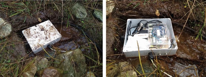
Innovative monitoring for hazardous slopes

Executive Summary
The aim of the Scottish Roads Research Board (SRRB) Innovative Monitoring Strategies project
has been to implement a novel multilevel modular monitoring system to detect landslide
activity prior to, during and after landslide events, providing a business case for appropriate
monitoring to enable cost-effective management of hazardous slopes in Scotland. Through
this research, new monitoring techniques have been developed and deployed at the A83
Glasgow–Argyll road at the “Rest and be Thankful” (RabT); the RabT is perhaps the most
challenging site managed by Transport Scotland where steep slopes above the road are
susceptible to repeated landslides. Some of the tested technologies are found to be
operationally ready and of clear and cost-effective benefit and hence are recommended for
immediate implementation, whilst others are likely to yield valuable new monitoring data
with further development/research phases prior to becoming operational options.
Of the monitoring techniques explored, it is recommended that the time-lapse photography,
on-slope weather gauges and terrestrial laser scanning (TLS) be taken forward for monitoring
immediately where known shallow landslide problems or perceived threats exist. The time-
lapse imagery is of high temporal resolution, and has been extremely successful in detecting
precursory movement on the monitored slopes as well as being able to determine timings for
debris-flow events, allowing them to be analysed with respect to trigger mechanisms such as
rainfall for the first time. The weather station analyses have proven that on-slope conditions
vary significantly from those recorded by nearby SEPA gauges, they are therefore vital for
effective hazard mitigation as opposed to generic forecast conditions. The repeat TLS has
modelled the slope surface at
Innovative monitoring for hazardous slopes

Whilst the outcomes of this project are directly applicable to Transport Scotland’s future
management of the RabT, they will also be of potential benefit to other locations on the
Transport Scottish network, and those of other road authorities that are susceptible to
landslides. The selection of individual techniques, or combination of techniques, for the
monitoring of other locations prone to landslides and the frequency of monitoring is likely to
be influenced by the geomorphology, potential failure characteristics, and, the likely drivers
of failure of the individual slopes.

First Issue                                   ii                                        PPR963
Innovative monitoring for hazardous slopes

Table of Contents
1     Introduction                                                      1

2     Achievements against stated objectives                            2

3     Innovative monitoring: Equipment installations and data outputs   7
      3.1        dSLR Time-lapse camera                                 7
      3.2        Trail camera time-lapse                                8
      3.3        Davis weather station                                  9
      3.4        Seismometers                                           9
      3.5        dGPS monitoring stations                               11
      3.6        Ground-Based Synthetic Aperture Radar (GB-SAR)         12
      3.7        Terrestrial Laser Scanning (TLS)                       13

4     Innovative monitoring: Equipment pros and cons                    16

5     Equipment recommendations and future directions                   18

6     Summary                                                           21

First Issue                                         iii                 PPR963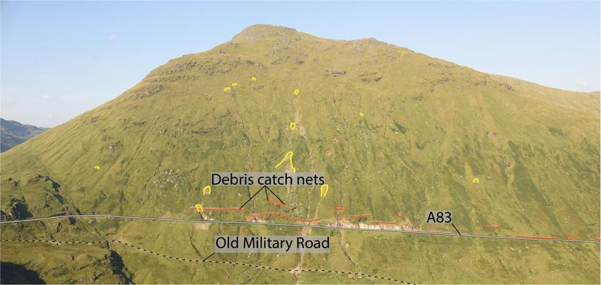
Innovative monitoring for hazardous slopes
1 Introduction
The south-west facing slopes of Beinn Luibhean have long presented a significant landslide
hazard to the A83 trunk road that traverses the slope to the Rest and be Thankful (RabT) car
park and connects large parts of mid-Argyll with the Central Belt of Scotland.
The A83 leading to the RabT has been subject to a number of closures in recent years due to
landslide activity which have necessitated the use of the Old Military Road as a diversion route.
These closures have led to the development of significant management and mitigation
options at the site which are planned to continue. In particular, significant work has been
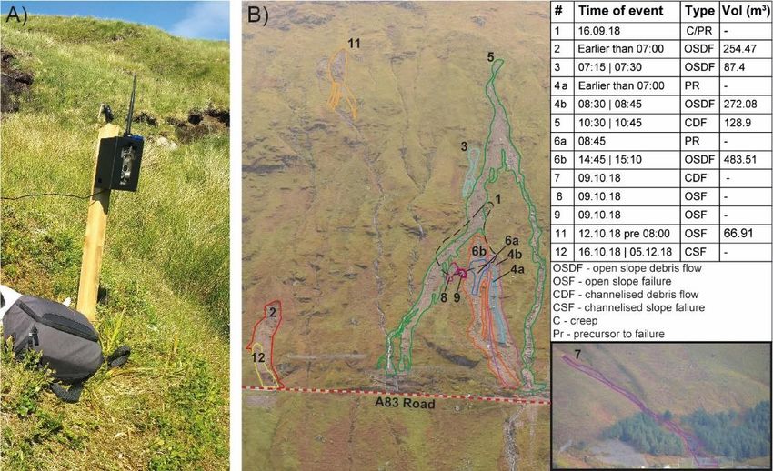
undertaken to monitor the slope above the A83 at this location (Figure 1; Sparkes et al. 2018
– TRL report PPR 852; Winter et al. 2017 – TRL report PPR 824).
Figure 1 Photo of the slope above the A83 Rest and be Thankful (BNG 223810,707213)
showing recent landslide source scars in yellow and debris catch net mitigation works in
red.
The work presented in this report describes the application of novel and innovative
techniques to support monitoring of the slope above the A83 and complements the work
reported by Winter and Ferreira (2019 – TRL Report PPR 908) to capture time-series
panoramic imagery.
The aim of the Innovative Monitoring Strategies project has been to implement a novel
multilevel modular monitoring system to detect landslide activity prior to, during and after
landslide events, providing a business case for appropriate monitoring to enable cost-
effective management of hazardous slopes in Scotland. It also allows a benchmark set of data
to be established prior to potential reforesting of the slopes above the RabT.
This report details the achievements that have been made against the stated grant objectives
(Section 2), shows the equipment installations at the RabT and provides example data
(Section 3), evaluates the pros and cons of each approach (Section 4), and gives firm,
summarised recommendations about each technology that has been utilised (Section 5). Data
First Issue 1 PPR963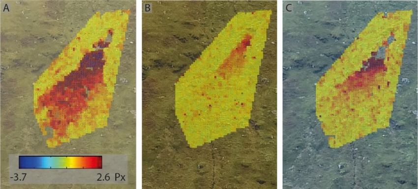
Innovative monitoring for hazardous slopes

are currently archived at Newcastle University / Northumbria University on behalf of
Transport Scotland, to whom any enquiries should be directed.
From 2017 to 2019 project equipment and time has been kindly funded by the Scottish Roads
Research Board. From August 2017-2019 a Newcastle University funded Post-Doctoral
Research Associate also worked on equipment installations and data processing. Time-lapse
camera equipment originally purchased by SRRB was subsequently repaired/replaced using
Newcastle University funds. Additional ‘event response’ terrestrial laser scans of the site
during October 2018 were also conducted outside of the project scope using university funds
and are therefore retained at Newcastle and Northumbria Universities. During the project,
negotiations commenced between Transport Scotland and the landowner regarding the sale
of the land. Limitations were imposed on access to the site during these negotiations, as
described in the text.

Abbreviations
DEM – Digital elevation model
dGPS – Differential global positioning system
dSLR – digital single lens reflex
GB-SAR – Ground-based synthetic aperture radar
NIR – Near infra-red
NTRIP – Networked Transport of RTCM via Internet Protocol
OSGB – Ordnance Survey Great Britain
RabT – Rest and be Thankful
ROI – Region of interest
SEPA – Scottish Environment Protection Agency
SRRB – Scottish Roads Research Board
TLS – Terrestrial laser scanning

First Issue                                     2                                    PPR963
Innovative monitoring for hazardous slopes

2         Achievements against stated objectives
The following section will set out the objectives stated in the SRRB Innovative monitoring
strategies for managing hazardous slopes project proposal and then show what outcomes
have been achieved against those objectives.

Objective 1: Epoch based surveys, supplemented with ‘event’ based responsive surveys
Epoch based, terrestrial laser scanning (TLS) surveys and photography aim to quantify changes
on the slope between each survey. TLS provides a centimetre scale method of developing
digital elevation models (DEMs) which can quantify 3D failure volumes or areas of instability.
Photographs of regions of interest (ROI) help to identify specific pre- and post-failure
conditions for analysis.

1. Change detection maps in OSGB; Digital Elevation Models
Change detection maps between epoch-based TLS surveys have been produced in OSGB
format along with high-resolution DEMs of each TLS survey. Cumulative loss and gain maps
of the RabT slope from March 2015 to November 2019 are available as well as individual GIS
shapefiles and depth rasters of failure scars and depositional areas.

2. Imagery for Regions of Interest (ROI) and vector plots of feature tracking
Imagery for Regions of Interest (ROI) has been collected by time-lapse camera installations,
ROIs have been utilised to generate feature tracking vector plots of deforming areas of slope
which signal precursory movement before failure. Monoplots (georeferenced imagery on
DEMs) of imagery have also been explored, however their usefulness has been superseded
by vector tracking software.
Epoch based Ground-Based Synthetic Aperture Radar (GB-SAR) surveys, which can monitor
the deformation of large-volume targets such as slopes, were carried out over three days in
differing weather conditions (clear, cloudy and rainy). The instrument collected good quality
data across all environmental conditions, and this points to the possibility that mm scale
deformation could be detected if a permanent installation was used. However, there was no
natural slope movement detected during the GB-SAR monitoring period, just ongoing works
by Geo-Rope, therefore the ability to detect small-scale deformations could not be confirmed.
Ideally the GB-SAR needs to be deployed during a storm event and be used to detect
precursory movement. The preliminary results from the data and complex processing
workflows will be reported separately in the journal Remote Sensing of Environment (Wang
et al., In Press).

Objective 2: Continuous monitoring
Continuous monitoring is useful for analysing in detail the slope conditions that have led up
to an event occurring. This includes the analysis of high-resolution weather data (rainfall, wind)
to look at antecedent conditions, tracking of single point differential GPS (dGPS) and tilt

First Issue                                     3                                          PPR963
Innovative monitoring for hazardous slopes

meters data, monitoring the slope with time-lapse imagery and the use of seismics to detect
and triangulate ‘noise’ sources, such as debris flows, on the slope.

1. Navstar Infrastructure, dGPS and weather station - GPS vectors of motion; on-slope
   rainfall for comparison to lower stations; long-term testing of Navstar infrastructure for
   real-time data provision
Two Navstar dGPS monitoring stations (Base and Rover stations) were installed in May 2016,
to monitor an area of the slope that was thought to be creeping, however due to the high
annual costs and 3rd party data portal it fell out of use in 2018 and was not maintained further.
dGPS monitoring was continued using lower cost Emlid Reach units. Real-time data streaming
and processing was achieved using these units, and this workflow will be taken forward using
new L2 dGPS units that can record sub-cm motions through time. Whilst the Reach units were
placed on areas that were expected to move, there was no motion over the monitoring period;
nonetheless they remain a targeted monitoring solution capable of 24/7 data in ROIs at a low
cost per sensor, they are also well suited to long-term monitoring of individual boulders
identified as posing a hazard.
The Navstar weather station was replaced with a near real-time streaming Davis weather
station placed centrally on the slope. The unit is continuously logging but sends data every 5
minutes. A comparison of the on-slope gauge to the nearby SEPA Loch Restil gauge shows
that on-slope conditions can be significantly different to those up valley (Table 1).

   Table 1 Forecast rainfall data from the Met Office and corresponding daily cumulative
    rainfall totals (millimetres) from the on-slope gauge run by Newcastle/Northumbria
                     Universities, and the nearby Vaisala and SEPA gauges

        Date               Forecast          Vaisala gauge   University gauge   SEPA gauge**
        October 2018       (mm)              (mm)            (mm)               (mm)

       Sun 7th             15 - 20*          28.6            57.2               64.8

       Mon 8th             25 - 30           27.0            56.8               86.6

       Tues 9th            42                37.1            86.6               30.0

       Wed 10th            0                 0               0                  0

       Thurs 11th          5 - 10            6.0             15.4               39.0

       Fri 12th            8 - 12            15.8            40.0               12.0

       Sat 13th            15 - 20           14.6            21.2               19.4
*forecast is from Friday 5th October 2018
**cumulative rainfall is from 9am to 9am, not 12am to 12am
Tilt meters were installed on sections of the slope that had had historic movement and were
identified as a likely area for further deformation. However, the tilt meter data did not reveal

First Issue                                          4                                         PPR963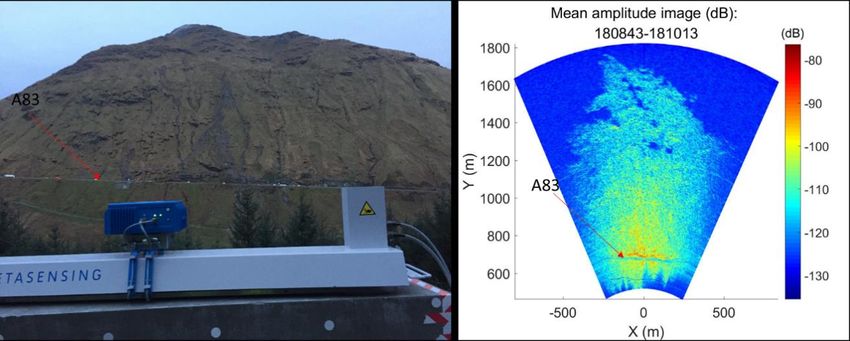
Innovative monitoring for hazardous slopes

any insight in to slope processes as they were easily disturbed in the upper soil profile by
weather, frost heave and vegetation. No further analysis of tilt meter data will be conducted
in this report.

2. Seismic Monitoring - Assessment of the use of industry standard and low-cost novel
   seismics to detect and locate events in real time for warning purposes; assessment of event
   magnitude assessment from seismic data when compared to volumetrics of events.
Restrictions on installation during negotiations for the intended land sale means that
installation of this equipment could only be completed in September 2019 towards the end
of the project. However, in a location with prior permissions but poorly suited to seismics, a
low-cost, novel, Raspberry Shake 3D seismometer was installed in summer 2018 and was
active during the October 2018 landslide event. Post-processed data was able to resolve one
of the debris-flows from 9th October 2018 including direction to the sensor. With the land-
sale now completed we have installed four Raspberry Shake 3D seismometers on the slope
for improved landslide detection and location. Real-time data capabilities have been tested
and are functional when stable communications are available. Alarm settings for event
detection need to be threshold driven from data collected during future landslide events.
A set of Guralp 6D seismometers were loaned from the NERC Geophysical Equipment Facility
in 2017; however due to restrictions on equipment installation because of the land sale these
were not installed and had to be returned in spring 2019. Therefore, an assessment of the
low-cost sensors to the industry standard seismometers has not been possible.

3. Time-lapse digital single lens reflex (dSLR) camera and lower resolution sensors -
   Assessment of ability of time-lapse systems to track ongoing deformation, and, provide
   timing of on-slope failures relative to drivers of failure; time-lapse videos
Two Harbortronics time-lapse cameras have been installed at the site, one on-slope
monitoring areas of interest and one across the valley with a wide-angled view of the entire
slope. The cross-valley installation has a full-frame dSLR giving high-resolution imagery of the
slope. This imagery has been used to detect precursory slope deformation before failure as
well as to corroborate open-slope failures detected by the TLS surveys. Deformation tracking
using sequential images has been conducted manually, however it is anticipated that future
monitoring will use automated tracking algorithms.
Two Little Acorn 6210MG trail-cameras have also been installed on the opposite valley-side
to the RabT. These low-cost cameras send low-resolution (2MP) images back to a designated
email account every 15 minutes and can be used for near real-time monitoring of the slope
during weather events and for time-sequencing of landslide events after landslides. Landslide
timings are important for integration with other data, such as rainfall, to determine
thresholds for landslide initiation.

First Issue                                    5                                          PPR963
Innovative monitoring for hazardous slopes

4. Low-cost dGPS monitoring stations - Continuous record of deformation of ROI;
   assessment of the reliability of dGPS point based measurements of on-slope activity as
   compared to photogrammetric.
Two Emlid Reach L1 dGPS units were installed on the slope as a base and rover respectively.
The rover was placed on an area that deformed during the 9th October 2018 landslide events
but did not fail. However, it did not move further during the dGPS monitoring period. Data
from the L1 rover unit show that they are not of high enough resolution at all times due to
poor sky view / satellite geometry to resolve cm scale ground deformation; the point scatter
for the majority of the data was up to 0.2 m up and down slope from the actual sensor location.
Improvements can be made to this setup either through temporal filtering, or, preferably by
using L2 dGPS sensors able to resolve cm scale deformation and by placing the base station
in a location with better sky view to allow for improved real-time corrections.

First Issue                                   6                                         PPR963
Innovative monitoring for hazardous slopes
3 Innovative monitoring: Equipment installations and data
outputs
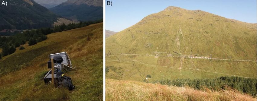
3.1 dSLR Time-lapse camera
A long-term solar charged Harbortronics time-lapse camera installation with a Nikon D800
full-frame dSLR camera was been installed at the RabT for the monitoring period. This allows
slope-wide photography every 30 minutes during clear conditions (Figure 2).
Figure 2 A) The dSLR installation and a co-located trail-camera; B) Photo from the dSLR
installation
Over the monitoring period the time-lapse imagery from this camera has been used to
pinpoint the times for landslide occurrence, both those that have impacted nets at the road
and open slope failures which have not reached the road. Camera images were also used to
detect precursory movement of material before failure in October 2018 and a report sent to
stakeholders (Figure 3).
Figure 3 Example deformation tracking from sequential time-lapse images showing higher
(dark red) and lower (yellow) rates of movement, in pixels, between images
Precursory movement was detected in retrospect on another open slope failure in August
2019. Software can automatically track this deformation from successive images; however it
First Issue 7 PPR963Innovative monitoring for hazardous slopes
has only been possible to do this retrospectively as camera images need to be downloaded
manually. Future upgrades to the dSLR should include near real-time data streaming and
automatic image tracking. Deformation tracking between images has clear potential for use
as a warning to authorities that material on the slope is moving and that there may be
increased risk.
3.2 Trail camera time-lapse
Little Acorn 6210MG trail cameras taking repeat photography of the slope every 15 minutes;
5MP images are taken and stored on unit and 2MP images are sent for remote rapid analysis.
Colour images are taken during the day and near-infrared (NIR) images taken at dawn and
dusk extending the effective monitoring capacity. Colour images have been used to sequence
landslide timings, specifically those in October 2018 (Figure 4).
Figure 4 A) Trail camera installation at the RabT; B) 9th October 2018 landslide sequencing
derived from time-lapse camera and trail camera data. Some landslides could be
narrowed to a 15-minute period
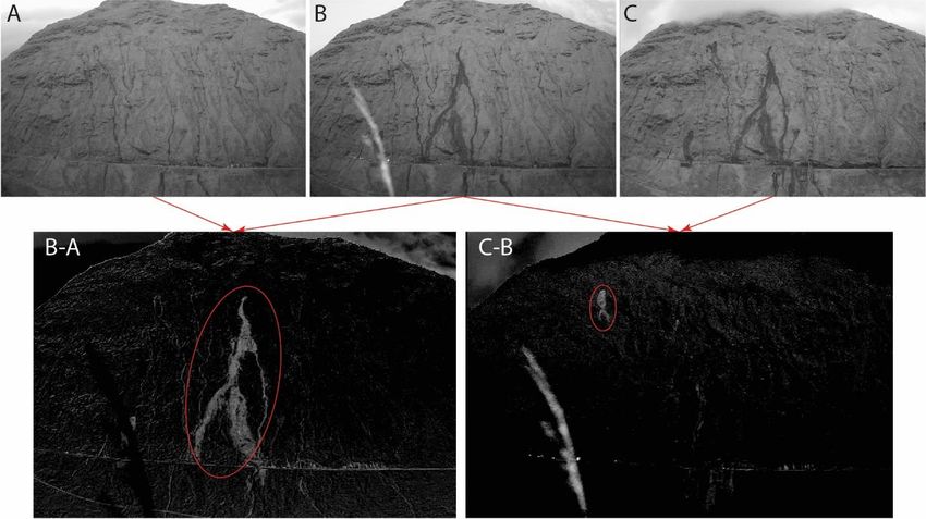
NIR images that are taken at dawn and dusk have shown that it is possible to extract
information on landslide occurrence by processing these images and subtracting sequential
images from each other (Figure 5).
Currently this NIR subtraction technique requires manual inputs, however progress has
recently been made in automating the process. Full automation requires further research and
development. The trail cameras serve a similar purpose to the dSLR camera but are
significantly cheaper and easy to install. At ~0.5mb per image, the data transmission
requirements are also much lower than those of the dSLR allowing for greater temporal
resolution of the data. Unfortunately, the low resolution of the images means that only large
events can be detected and no detection of precursory deformation is possible.
First Issue 8 PPR963Innovative monitoring for hazardous slopes
Figure 5 Example of the Near Infra-Red (NIR) image subtraction technique used on the
trail-camera imagery to detect debris-flows that reached the road and smaller open slope-
failures which did not reach the road
3.3 Davis weather station (Vantage Pro2)
The on-slope weather station logs data directly and provides near real-time (5 min) data
transmission to an online viewable data portal (Figure 6). Data include rainfall, rain rate,
temperature, wind speed and wind direction. The weather station streams the data back to a
portal where it can be accessed by stakeholders.
Figure 6 Continuous rainfall data for the period 7th October to 13th October 2018. Hourly
and cumulative rainfall over the period are shown along with the timings of events (red
lines) as detected on the time-lapse camera imagery
Using the timings of landslide events from the cameras, the data from the weather station
can be used to examine the rainfall thresholds (duration-intensities) required to trigger
landslide activity on the slope (Winter et al., (2019).
3.4 Seismometers
Four Raspberry Shake 3D seismometers are currently installed on the RabT (Figure 7) close to
areas which may be expected to produce landslides. They log data to the unit but can be
First Issue 9 PPR963Innovative monitoring for hazardous slopes
configured to stream data in real-time - this configuration is ready to be deployed when stable
communications are available.
Figure 7 An example of one of the Raspberry Shake seismometer installations. The units
are housed within an IP67 waterproof box with a separate battery box adjacent to the
installation
Seismometer data can be displayed and used in a number of ways. The basic trace (Figure 8A)
shows the digitised signal from the 3-axis geophones on the seismometer unit; alarms can be
set whereby if a threshold of ‘noise’ is reached then alerts can be sent to key stakeholders.
These alarms are usually based on a ratio of the short-term to long-term average of the trace
and if that ratio is exceeded by a large event.
Figure 8 Example seismometer data from October 2018. These data show a 20 minute
section of data where man-made drilling noise was occurring on the road side. A) East and
North axis, filtered, geophone traces showing the ‘noise’ of periodic drilling in the A83
catch-pits. B) Peaks in the frequencies of the same dataset, diagnostic frequencies of
debris flows and be used to identify them in the seismic signal.
Figure 8B shows the spectrogram of the same section of data as Figure 8A. However, here the
frequencies of the ‘noise’ being detected by the seismometers can be examined. The principal
noise detected was man-made, comprising drilling for the construction of catch-pits at the
side of the A83. Peaks in frequencies can be seen at ~10Hz, 20Hz and 30 Hz. Landslides and
debris flows also have characteristic traces and frequency descriptors that can potentially be
thresholded using the seismometers installed on the slope to automatically detect and locate
events in real-time.
First Issue 10 PPR963Innovative monitoring for hazardous slopes
3.5 dGPS monitoring stations
A dGPS base and real-time deformation tracking rover were temporarily installed on the site.
The base was securely located in an area which was not moving and the rover was placed in
an area that had moved during the October 2018 landslide events, but had not transitioned
into a long-runout failure. Real time streamed and processed corrected positions can be
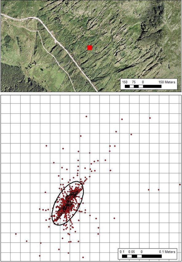
obtained and plotted from the Emlid dGPS units and an NTRIP server process (Figure 9).
Figure 9 Location of dGPS testing (upper), and, (lower) all Q1 (best quality fixed points)
points with a 0.05 m grid overlain. The ellipse encompassing most data is approximately.
0.2m x 0.11m.
Data show that the single channel (L1) units have a relatively large area of scatter for an area
that did not move during the data collection period (Figure 9). This is due to the L1 based GPS
units being less accurate than more advanced counterparts, and the poor sky view of the
rover unit (>50% of the sky is obscured on the RabT slope leading to poor satellite
configurations). Improvements can be made on this by installing 2 channel (L2) units as well
as moving the base station to the opposite valley side with a better sky view. New L2 circuit
board units, which are cheaper than the Emlid L1 units, but were not available at the start of
First Issue 11 PPR963Innovative monitoring for hazardous slopes
the work, are currently being tested for deployment but require further research and
development to complete a quality assessment.
3.6 Ground-Based Synthetic Aperture Radar (GB-SAR)
A concrete plinth has been installed on the forest track opposite the RabT slope (although this
has recently been unseated by track re-grading machinery). A Meta-sensing GB-SAR was
mounted on this plinth for three days across clear, cloudy and rainy conditions to assess the
effectiveness of the system in detecting millimetre scale deformation (Figure 10A). The GB-
SAR detects any deformation towards the instrument; Figure 10B shows the strength of the
signal being returned from the forest track.
A) B)
Figure 10 A) GB-SAR installed on concrete plinths facing the A83; B) Mean amplitude
strength image generated
GB-SAR relies on coherence between scans, where there is significant activity (works, traffic)
there is likely be no coherent (useable) data. As expected in the deployment conditions there
was no significant displacement detected in these data above/below road level, other than at
road level where construction activity at the side of the A83 could be seen and coherence
between data acquisitions was maintained (Figure 11).
Figure 11 Displacement map from a 10-minute data acquisition in intermittent visibility
conditions; three picked points illustrate the low levels of noise in these data; green
colours in the map denote no change, with corresponding flat lines in the displacement
graphs showing little variability on the y-axis across the 10 minute time series.
First Issue 12 PPR963Innovative monitoring for hazardous slopes
Data in Figure 11 show the stability of the time-series and processing algorithm. Further
analyses will be able to use our existing TLS topographic data to both improve the GB-SAR
processing and to geo-reference these data into a common coordinate system.
3.7 Terrestrial Laser Scanning (TLS)
Between March 2015 and November 2019 there have been 27 TLS scans of the slope; recent
scans were conducted with a Riegl VZ400 TLS (Figure 12; Table 2). Spatial resolution for the
scans is < 0.20 m since May 2018 when the VZ4000 came into operation. Change detection is
conducted between consecutive scans to accurately visualise loss and gain of material on the
slope (Figure 13) and calculate the magnitude of failures.
Figure 12 Riegl VZ4000 TLS being used from the forest track to scan the RabT slope
Cloud Compare M3C2 change detection software has been used to extract change between
two consecutive scans and remove noise from the data such as vegetation growth/loss
between scan epochs. A bespoke ArcGIS tool is then able to use the point cloud data from the
M3C2 change outputs and calculate the area and volumes of the loss and gain of material.
Epoch based and cumulative change detection maps (Figure 13) can then be created within
ArcGIS to highlight areas of higher activity on the slope and volume of material removed from
the slope. These data can generate new hazard models for the slope and inform our
understanding of the slope failure processes involved.
First Issue 13 PPR963Innovative monitoring for hazardous slopes
Table 2 A list of terrestrial laser scan data of the RabT held by Newcastle and Northumbria
Universities
Year Project Scan date Scanner
17th March Riegl LMS Z620i
20th April Riegl LMS Z620i
29th July Riegl LMS Z620i
2015
8th September Riegl LMS Z620i
16th October Riegl LMS Z620i
Bradley Sparkes’ PhD
6th December Riegl LMS Z620i
11th February Riegl LMS Z620i
24th May Riegl LMS Z620i
26th July Riegl VZ4000
2016
19th September Riegl LMS Z620i
26th November Riegl LMS Z620i
17th December Riegl LMS Z620i
29th January Riegl LMS Z620i
3rd February Riegl LMS Z620i
2017
27th April Riegl LMS Z620i
16th November Riegl LMS Z620i
Innovative Monitoring Contract
23rd January Riegl LMS Z620i
24th May Riegl VZ2000s
2nd October Riegl VZ4000
2018
10th October Riegl VZ4000
15th October Riegl VZ4000
13th November Riegl VZ4000
26th March Riegl VZ4000
Contract – No cost,
29th June Riegl VZ4000
time extension
Monitoring
Innovative
2019
12th September Riegl VZ4000
3rd October Riegl VZ4000
1st November Riegl VZ4000
First Issue 14 PPR963Innovative monitoring for hazardous slopes
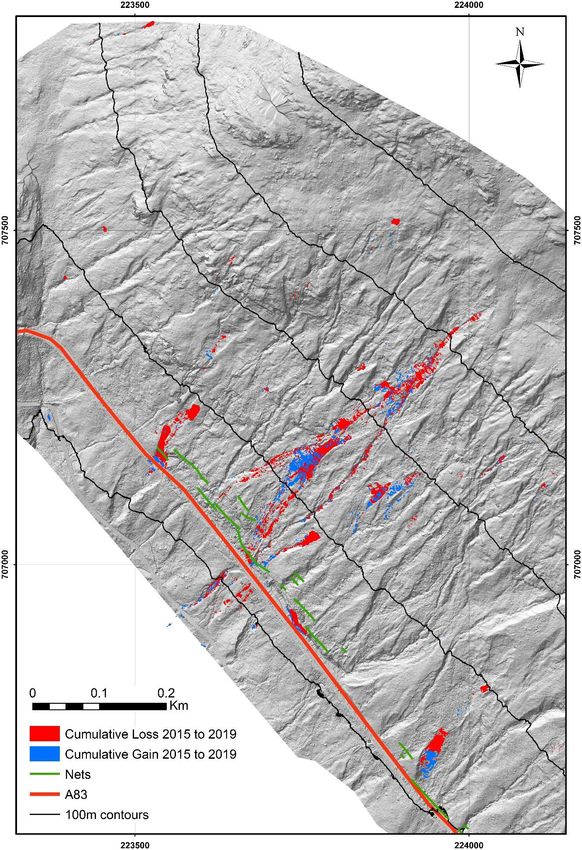
Figure 13 Terrestrial laser scanning data for the monitoring period March 2015 to
September 2019. The map shows the cumulative loss and gain of material over the slope
for the entire monitoring period. The data are draped over a digital elevation model
(DEM) derived from the November 2018 point cloud data (widest coverage dataset) but
DEMs exist for all laser scan dates
First Issue 15 PPR963Innovative monitoring for hazardous slopes
4 Innovative monitoring: Equipment pros and cons
Equipment Purpose Data Pros Cons
interval
dSLR time-lapse Optical imagery of the 30 minutes - Easily adapted to send data back in near real- - Currently manual download
camera slope for manual or time rather than manual download - 30 minute data – can only detect change
automated tracking of - Proven to be able to detect precursory every 30 minutes
deformation/failure of movement on the slope during and after storm - Cannot see through cloud or at night
slope material. events.
- Easy to maintain
- Full frame camera images (36MP)
Trail cameras Optical imagery of the 15 minutes - Images sent back to Newcastle in near real-time - Low resolution, 5MP on the unit and 2MP
slope for viewing large - Proven to be useful in determining landslide data sent back
scale slope changes event timings – these cameras have been used to - Cannot see through cloud or at night
(failures) narrow down time-windows for events which can
then be compared to other factors such as
rainfall.
- Takes an NIR image at dawn and dusk which can
be used to detect new changes on the slope
- Low-cost
Weather station Rainfall, rain intensity, Constant - Show actual on slope conditions. - Currently requires mobile signal which can
wind and temperature data but 5 - Near real-time data be intermittent (being upgraded to Wi-Fi)
data for actual on slope minute - Can be used by the USGS forecast model to
conditions rather than web-based generate rain thresholds and alerts
other gauges near the update rate - Adaptable system where additional gauges can
site. be added for relatively little expense
Seismometers Seismic monitoring Millisecond - 24 hour operation and detection of events, - Large installation footprint (5-6m2)
from 4 stations on the including night time and during bad weather - Power hungry as they are constantly
slope. Debris-flows - Streaming of data in real-time running
should be detected by - Alarms trigger when an event is detected – - They require further research to threshold
these instruments and seismic data from the event can be mobilised the event detection and minimise false
alarms sent to quickly for a review & response. alarms
stakeholders
First Issue 16 PPR963Innovative monitoring for hazardous slopes
dGPS Base station and RTK Continuous - Real-time streaming of data from the slope to a - Need to ID areas of concern (from time-
rover station on the requested place lapse) then place instruments
slope. Rover stations - Centimetre accuracy - Errors need constraining in order to avoid
can be quickly - Low cost, and therefore rover stations may be false alarms
deployed to areas of considered ‘disposable’ if placed on an area that - Currently only L1 units (~20cm accuracy) but
concern to record real- eventually fails. L2 (1cm accuracy) units are available to
time deformation data. - Easy to deploy and therefore could have good deploy.
spatial/temporal coverage of areas of concern.
GB-SAR Detect near real-time, Constant - Detection of millimetre scale slope deformation - Expensive (>£200k)
(potentially) millimetre data - Weather independent; however detection - Requires a lot of power
scale slope collection resolution is affected in bad weather. - If deformation is too rapid then change
deformation from a with 10 - Short time epoch for receiving change data detection will lose coherence and only
fixed installation on the minute - Can potentially be set up for near real-time data record a void in the data.
forest track opposite change streaming - Requires large, fixed concrete blocks for
the slope detection mounting – blocks were installed but have
intervals been dislodged from their mount during
track regrading.
- Line of sight deformation
TLS Highly accurate 3D Epoch - Accurate (10cm) slope models - Reactive data collection, ‘what has already
laser scans of the slope based - Derived parameters from scans include: happened’
are produced; scanning – source/deposit volume, areas of scour, areas of - Time intensive
consecutive scans can on average deformation and cross-sectional areas. - Expensive for a fixed station
be ‘differenced’ to every 4 - Detection of ‘missed’ events - Will not penetrate cloud, limited ability to
produce an accurate months - Proven and benchmarked data measure through rain
model of change on the - Data has been used by Jacobs for their boulder
slope between the two study
scans used. - Can confirm precursory movement detected by
other methods
Tilt-meters Record the Continuous - Very small and easily installed - Requires manual download
tilt/movement of the - Data was not useful as the instrument
sensor to assess appears to have been too sensitive to
whether the ground is external forcing such as wind, frost-heave,
moving vegetation etc.
First Issue 17 PPR963Innovative monitoring for hazardous slopes
5 Equipment recommendations and future directions
The items of equipment that have been installed and tested at the RabT, along with their
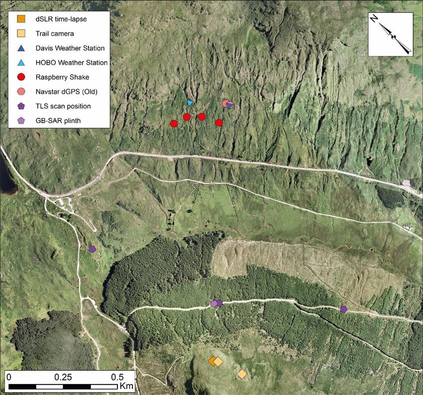
installation locations are shown in Figure 14. Recommendations for each item are given below.
Figure 14 Locations of installed equipment in Glen Croe
dSLR time-lapse camera: Recommended for immediate consideration in operational
monitoring of unstable slopes. This equipment is operationally ready and will provide cost-
effective essential slope change data to future monitoring strategies. Whilst the manual
download of data has been useful, any future installations should consider near real-time data
transmission. Research needs to be completed on making deformation tracking an automated
process between images. There is one dSLR station facing the slope and we recommend
leaving it installed and supporting future maintenance.
First Issue 18 PPR963Innovative monitoring for hazardous slopes Trail cameras: Recommended where qualitative and high temporal resolution data on slope conditions are critical. Trail cameras provide low cost and very easily deployed imagery but low resolution images hamper the detection of any small slope failure events. The advantage of these units over the dSLR time-lapse is their lower cost and the near real-time data transmission; however, this will be superseded by a new streaming dSLR time-lapse (data transmission costs will be higher). Future work should explore the use of near-infrared (NIR) camera technology to monitor the slope in low-light conditions. There are two near real-time streaming trail cameras facing the slope, we recommend leaving them installed until they are superseded by the dSLR. Seismometers: Recommended as a likely future monitoring approach for both slope movement and changes in slope subsurface conditions. These instruments allow continuous, weather independent, 24 hour monitoring of the slope. They can be fitted with Wi-Fi/3G capabilities in order to stream data and create alert systems for slope management. One station installed during October 2018 did detect one of the debris-flow events, however restrictions on deployment locations due to the land sale meant that this data was not ideal. A network of four, well placed instruments is currently monitoring the slope. We recommend the seismometer installations should remain in place and be maintained so that data on ambient ‘noise’ and characteristic debris flow signals can be collected. The network could be extended if more areas of risk were identified. Weather stations: Recommended for immediate consideration in operational monitoring of unstable slopes. A network of rainfall sensors should ideally be placed across the problem slope to examine differential slope conditions. Data should be analysed through the USGS ‘Thresh’ (or similar) software to provide intelligent alerts to stakeholders of higher-risk conditions on the slope. Piezometer data could compliment the weather station data in determining local ground-saturation thresholds for slope failures but at the RabT ground water appears to be highly variable and channelized so caution should be exercised. The single weather station on the slope has been able to record continuous rainfall, wind, and temperature data for over a year with derived rain intensity measurements. Data comparison with the SEPA Loch Restil gauge has shown that the RabT receives significantly different weather conditions to that of surrounding areas. The Met Office made the following comment regarding the RabT after the October 2018 events: “It would be good to have some site analysis carried out to identify site specific characteristics of the RBT, for example how certain wind directions affect the expected rainfall amounts - whether there is orographic enhancement or shelter from particular directions. This could then be used to improve the forecast.” We have recently trialled a profile of three weather stations on site that should help inform and refine understanding of potential orographic effects on rainfall dispersion across the slope. Although beyond the scope of this study, findings and data will be available to Transport Scotland. First Issue 19 PPR963
Innovative monitoring for hazardous slopes

TLS: Recommended for immediate consideration in operational monitoring of unstable
slopes. These data identify active areas, establish patterns and sequences and enable future
projections of slope movements, and thus are valuable for any future slope monitoring
strategy. TLS data have enabled the detection of slope failures that did not reach the road
and therefore remained undocumented but could remobilise or propagate in subsequent
events. The data allow the extraction of debris flow volumes and source area shapes which
may help us understand the processes working on the slope. The project has continued a well-
established approach, combining regular surveys with responsive change detection data
collections, we strongly recommend this continues.

GB-SAR: The GB-SAR requires further testing to ascertain its viability for slope monitoring.
It is suited to sites with high value assets / high loss potential due to equipment costs and
power considerations. Initial tests show that the Fast GB-SAR is able to detect millimetre
deformation on the slope from the Forest Enterprises track by collecting radar images of the
slope every 10 minutes. Two concrete slabs were installed on the forest track to support the
instrument, but these have been displaced during the regrading of the track. A long term
installation has not been tested and ideally the instrument would be deployed during a storm
or other high-rainfall event to test the real-time detection of on-slope deformation.

dGPS: Recommended for consideration in unstable slopes where potential areas of
precursory movement, or, boulders of concern can be accessed. Single-channel L1 dGPS units
have shown promise in live data streaming and relatively good position accuracy (~0.20 m).
However, greater accuracy is required to track real-time slope deformation and avoid false
alarms. New 2-channel L2 dGPS units are now available that should provide sub-centimetre
accuracy and can be deployed if any precursory movement is detected from the TLS or dSLR
time-lapse analyses.

First Issue                                  20                                        PPR963
Innovative monitoring for hazardous slopes

6         Summary
The aim of the Innovative Monitoring Strategies project has been to implement a novel
multilevel modular monitoring system to detect landslide activity prior to, during and after
landslide events, providing a business case for appropriate monitoring to enable cost-
effective management of hazardous slopes in Scotland. Through this research, new
monitoring techniques have been developed and deployed at the A83 Glasgow–Argyll road
at the RabT, satisfying the objectives that were stated in Section 2.
Some of the tested technologies are found to be operationally ready and of clear and cost-
effective benefit and hence are recommended for immediate implementation, whilst others
are likely to yield valuable new monitoring data with further development/research phases
prior to becoming operational options.
The outcomes of this project are directly applicable to Transport Scotland’s future
management of the RabT but will also be of potential benefit to other locations on the
Transport Scottish network, such as A82 Glen Coe, and those of other road authorities that
are susceptible to landslides. The selection of appropriate techniques, or combination of
techniques, for the monitoring of other locations prone to landslides and the frequency of
monitoring is likely to be influenced by the geology and geomorphology of the individual
slopes.

Acknowledgements
We would like to thank the Scottish Roads Research Board for the kind grant funding which
has made the research and technology development for the project possible. We would also
like to thank Paul Mellon and George Fiddes at Transport Scotland, Mike Baxter at BEAR
Scotland, GeoRope geotechnical engineers and Mike Winter who have all provided invaluable
support on data, site specific expertise and site access for the project.

References
Sparkes, B, Dunning, S A, Lim, M & Winter, M G (2018). Monitoring and modelling of landslides
in Scotland: characterisation of slope geomorphological activity and the debris flow geohazard
(PPR 852). Wokingham: TRL.
Winter, M G, Sparkes, B, Dunning, S A & Lim, M (2017). Landslides triggered by Storm
Desmond at the A83 Rest and be Thankful, Scotland: panoramic photography as a potential
monitoring tool (PPR 824). Wokingham: TRL.
Winter, M G and Ferreira, B (2019). Managing hazardous slopes: high resolution panoramic
imagery for monitoring purposes (PPR 908). Wokingham: TRL.
Winter, M G, Ognissanto F & Martin L A (2019) Rainfall Thresholds for Landslides Deterministic
and Probabilistic Approaches (PPR 901). Wokingham: TRL.
Wang, Z, Li, Z, Dunning, S, Bainbridge, R, Li, Y, Li, B, Chen, L & Mills, J (In Press) Atmospheric
correction in Ground-Based Synthetic Aperture Radar (GBSAR) interferometry for all-weather
landslide monitoring.

First Issue                                     21                                         PPR963
Innovative monitoring strategies for managing hazardous slopes

The aim of the Innovative Monitoring Strategies project has been to implement a novel multilevel
modular monitoring system to detect landslide activity prior to, during and after landslide events.
Through this research, new monitoring techniques have been developed and deployed at the A83
Glasgow–Argyll road at the “Rest and Be Thankful” (RaBT); the RaBT is perhaps the most
challenging site managed by Transport Scotland where steep slopes above the road are susceptible
to repeated landslides. Some of the tested technologies are found to be operationally ready and of
clear and cost-effective benefit and hence are recommended for immediate implementation,
whilst others are likely to yield valuable new monitoring data with further development/research
phases prior to becoming operational options.

Other titles from this subject area
PPR 908       Managing hazardous slopes: high resolution panoramic imagery for monitoring purposes. M G Winter
              and B Ferreira. 2019
PPR 852       Monitoring and modelling of landslides in Scotland: characterisation of slope geomorphological activity
              and the debris flow geohazard. B Sparkes, S A Dunning, M Lim & M G Winter. 2018
PPR 824       Landslides triggered by Storm Desmond at the A83 Rest and be Thankful, Scotland: panoramic
              photography as a potential monitoring tool. M G Winter, B Sparkes, S A Dunning & M Lim. 2017

TRL                                                                               ISSN 2514-9652
Crowthorne House, Nine Mile Ride,
Wokingham, Berkshire, RG40 3GA,                                                   ISBN 978-1-913246-47-1
United Kingdom
T: +44 (0) 1344 773131                                                            PPR963
F: +44 (0) 1344 770356
E: enquiries@trl.co.uk
W: www.trl.co.uk
You can also read