QUATERNARY GLACIATIONS AND CHRONOLOGY
←
→
Page content transcription
If your browser does not render page correctly, please read the page content below
CHAPTER

QUATERNARY GLACIATIONS AND
CHRONOLOGY

   1
                                                                                                                       4
                                                                                       J. Ehlers1, P.L. Gibbard2, and P.D. Hughes3
    Witzeeze, Germany, Scott Polar Research Institute, Cambridge, United Kingdom, 3The University of Manchester,
                               2

                                                                                    Manchester, United Kingdom

4.1 INTRODUCTION
Since the recognition in the mid-19th century that glaciers had been considerably more extensive
than at present, the Quaternary (Pleistocene and Holocene series) has been synonymous with glacia-
tion of the mid-latitudes. Today evidence from both the land and ocean-floor sediment sequences
demonstrates that the major continental glaciations occurred repeatedly over what are now temperate
regions of the Earth’s surface. The climatic variation that characterizes the Earth’s climate during the
late Cenozoic, and indeed before, is controlled by variations of the Earth’s orbit around the Sun that
therefore controlled the receipt of solar energy at the Earth’s surface. These Milankovitch variations,
named after the Serbian mathematician, their discoverer, are responsible for the cyclic climate
changes that characterize the Quaternary and indeed much of Earth’s history. One of the most critical
ways in which the Milankovitch climate cyclicity is expressed is through the development of ‘Ice
Ages’ or periods when glaciation extended across large areas of the Earth (Ehlers et al., 2016).

4.2 PRELUDE TO THE QUATERNARY
The onset of the recent ice age dates back much further than the Quaternary. An overall, long-term
trend of cooling global climates occurred throughout the Tertiary Period. The opening of the North
Atlantic Ocean, accompanied by the simultaneous closure of the east west-aligned Tethys Ocean,
characterize this period. This development led to profound palaeogeographical rearrangements and
initiated major changes in the circulation patterns of the ocean atmosphere system. In particular, the
drift of Antarctica to its position over the South Pole and the restriction and isolation of the Arctic
Ocean are jointly responsible for the marked zonation of climate since transfer of energy to the polar
regions became progressively more limited with the drifting of the continents and the associated
uplift of young mountain belts, including the Alpine-Himalayan chain, through the period.
    One of the consequences of the continent/ocean distribution on the Earth’s surface was glaciation.
Apart from some limited activity in the Eocene both in the Southern and Northern Hemisphere
(Ingólfsson, 2004; Tripati et al., 2005; Stickley et al., 2009), significant glaciation began in the late
Oligocene (c. 35 Ma) in eastern Antarctica (Ingólfsson, 2004). It was followed by mountain glaciation
Past Glacial Environments. DOI: http://dx.doi.org/10.1016/B978-0-08-100524-8.00003-8
© 2018 Elsevier Ltd. All rights reserved.                                                                                      77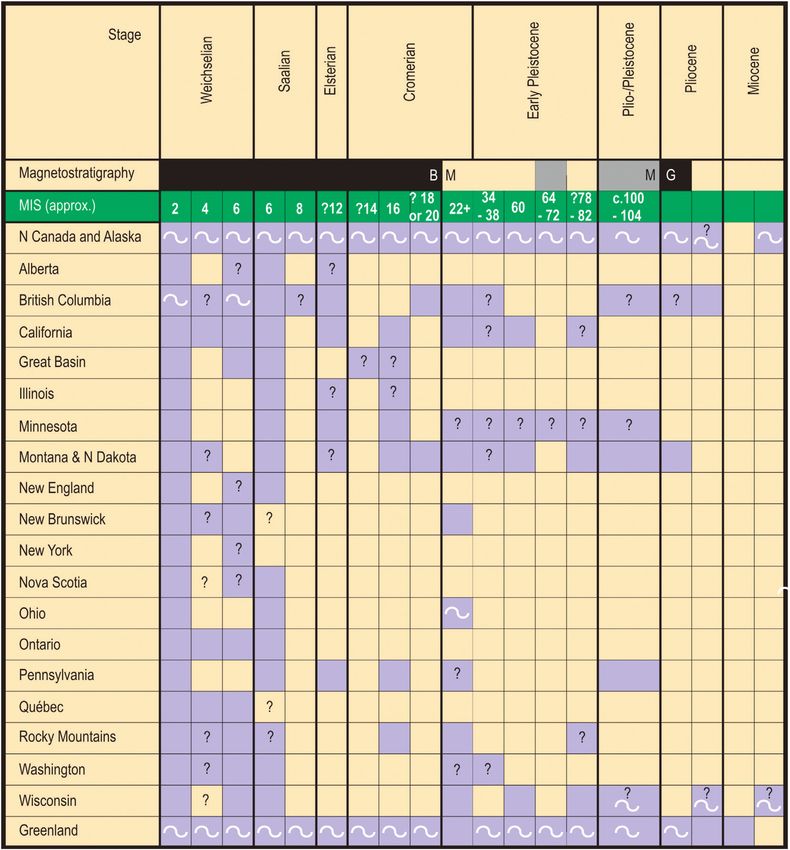
78        CHAPTER 4 QUATERNARY GLACIATIONS AND CHRONOLOGY

 BOX 4.1 THE QUATERNARY PERIOD/SYSTEM AND ITS SUBDIVISION
 The Quaternary Period/System, formally defined as beginning 2.58 million years ago, is represented in marine and
 terrestrial sediment sequences worldwide. Its base, and that of the Pleistocene Epoch/Series, were lowered in 2009 to the
 Global Boundary Stratotype Section and Point (GSSP) at Monte San Nicola, Sicily, Italy (Gibbard and Head, 2010;
 Gibbard et al., 2010; Head and Gibbard, 2015b), which had been established for the Gelasian Stage (formally the
 uppermost stage of the Pliocene) in 1996 (Rio et al., 1998). Thus the Gelasian now represents the lowest stage of the
 Quaternary, and is succeeded by the Calabrian Stage, which in 2011 was defined by the former Pleistocene GSSP at
 Vrica, Calabria, southern Italy, with an age of 1.80 Ma (Cita et al., 2012).
     The only other GSSP currently ratified for the Quaternary defines the base of the Holocene Epoch/Series. It was
 established in 2008, and is defined in the North Greenland Ice Core Project’s NGRIP2 ice core, with an age of 11,700
 calendar years before 2000 (Walker et al., 2009).
     That no other GSSP is located in an ice core emphasizes the creativity required to meet the high-precision
 correlations demanded of Quaternary stratigraphy. At the time of writing only three GSSPs have been defined for the
 Quaternary, leaving much work to be done for the future. In particular, the Lower (Early)-Middle Pleistocene and
 Middle-Upper (Late) Pleistocene subseries boundaries, will be formally defined in the near future (Fig. 4.1).

through the Miocene (23 5.3 Ma) in Alaska, Greenland, Iceland, and Patagonia, and later in the
Pliocene (5.3 2.6 Ma) in the Alps, the Bolivian Andes, and possibly in Tasmania.
    From the Neogene, glacially derived ice-rafted debris (IRD) is found in ocean-sediment cores
from the North Atlantic region, including the Barents Sea (Moran et al., 2006), and areas adjacent to
Norway, north and southeast Greenland, Iceland, and northern North America, and in the Southern
Ocean off Antarctica (De Schepper et al., 2014), bearing witness to the early glaciations (Box 4.1).

4.3 GLACIATION DURING THE QUATERNARY
The beginning of the Quaternary, the Early Pleistocene (2.6 0.8 Ma) was characterized by climatic
fluctuations dominated by the 41 ka orbital precession cycle, during which relatively few cold peri-
ods were sufficiently cold and long to allow the development of substantial ice sheets. Only 14 of
the 41 cold stages of that period currently show evidence of major glaciation. They include the
Plio-Pleistocene boundary events Marine Isotope Stage (MIS) 104, 100, and 98, together with Early
Pleistocene MIS 82, ?78, 68, 60, 58, 54, 52, 36, 34, ?30, and 26 which reach @ 18O ocean water
ratios of c. 4.6 5%o.
    Extensive ice-rafting, an indication that glaciers had reached sea-level, is found from the earliest
cold stage (2.6 2.4 Ma) in both the North Atlantic and North Pacific oceans (cf. Haug et al.,
2005). Synchronous glaciation of the Greenland, Scandinavian, and North American regions began
at 2.72 Ma (MIS G6), a dramatic increase in IRD at 2.7 Ma in the western sub-Arctic Pacific indi-
cates apparent circum-Arctic expansion of ice sheets (Bartoli et al., 2005), potentially relate to the
closure of the Panama Isthmus (Kameo and Sato, 2000). Further significant ice-sheet expansions in
the Nordic Seas and North Atlantic between 2.7 and 2.4 Ma, correspond to cold MIS 104, 100, 98,
and 96 (Kleiven et al., 2002). Changes also occurred in the Southern Hemisphere, where synchro-
nous peaks in IRD at 2.9 2.7 Ma off the Antarctic Peninsula and southeast Greenland indicate the
increase in intensity of glaciation was a global event (St. John, 2008).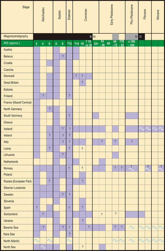
4.4 PLIO-PLEISTOCENE GLACIATION                     79

    It was not until the transition in dominant orbital cyclicity to the 100 ka cycles, that began
c.1.2 Ma and was fully established by about 800 ka (‘Early-Middle Pleistocene transition’, EMPT),
that the cold periods (glacials) were regularly cold and long enough to allow ice-sheet development
on a continental scale, outside the polar regions (Head and Gibbard, 2005, 2015a). However, it was
during MIS 22 (c. 870 880 ka) that the first of the ‘major’ cold events reached critical values of c.
5.5 or above @ 18O ocean%o equivalent to substantial ice volumes that typify glaciations of the later
Pleistocene (i.e., MIS 16, 12, 10, 6, 4 2). Potentially therefore, it is likely that there were a minimum
of 20 periods during which extensive glaciation could have developed during the last 2.6 million
years, with the most extensive (c. 5 6 periods) being limited to the last 900 ka (Fig. 4.1).
    Precisely where these glaciations occurred and how far they extended is very difficult to deter-
mine, given that the remnants of less extensive earlier glaciation tends to be obliterated and mostly
removed by later, more extensive ice advances. Although this is so in all terrestrial areas, it is espe-
cially in mountain regions that the preservation potential of older sequences rapidly diminishes
with time and subsequent glaciation.
    Examination of the frequency of glaciation through the Cenozoic (Fig. 4.2) indicates that glacia-
tion in the Southern Hemisphere was established first in Antarctica and southern South America,
where it occurred continually from the early Neogene to the present day.
    By contrast, Northern Hemisphere glaciation, although initially somewhat restricted, increased
markedly at the beginning of the Quaternary, increasing again in frequency in the latest Early
Pleistocene and reaching very high levels in the Middle-Late Pleistocene. Whilst this pattern is not
unexpected, the striking increase in ice-sheet size through the Quaternary clearly emphasizes that,
based on the distribution of land mass in higher latitude land mass, worldwide glaciation is in effect
a northern-hemispheric phenomenon.
    Examination of the evidence accumulated in the INQUA project Extent and Chronology of
Quaternary Glaciations (Ehlers and Gibbard, 2004a,b,c; Ehlers et al., 2011a; Fig. 4.3), supported
by other published sources, demonstrates the current state of knowledge. When examining the
resulting tables (Tables 4.1 4.3) it is important to bear in mind that the stratigraphical control
beyond the range of radiocarbon dating is weaker than might be desired. This is particularly a
problem outside Europe where biostratigraphy is less well developed and the sheer extent of the
unexplored regions makes future discoveries likely. Thus the presentation below can only be a first
step toward a comprehensive overview. The correlations applied here are based on the Global
Correlation Chart (Gibbard and Cohen, 2008) (Box 4.2).

4.4 PLIO-PLEISTOCENE GLACIATION
Evidence of glaciation is widespread from throughout the Quaternary and indeed the Neogene in
the Northern Hemisphere. The longest sequences are restricted to Alaska, and the adjacent North-
West Territories of Canada which, together with Greenland and the Rockies, preserve evidence of
glaciation from the Neogene to the present. In northern Canada and Alaska, the oldest till and
accompanying IRD in marine settings, dates from the Early Miocene, with regionally widespread
glaciation occurring in the Pliocene and regularly throughout the Pleistocene (cf. Haug et al.,
2005). In adjacent British Columbia a comparable sequence is found, particularly in the north.
Similarly, in Greenland and Iceland glaciation began in the Miocene, occurring regularly through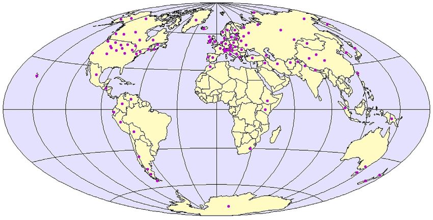
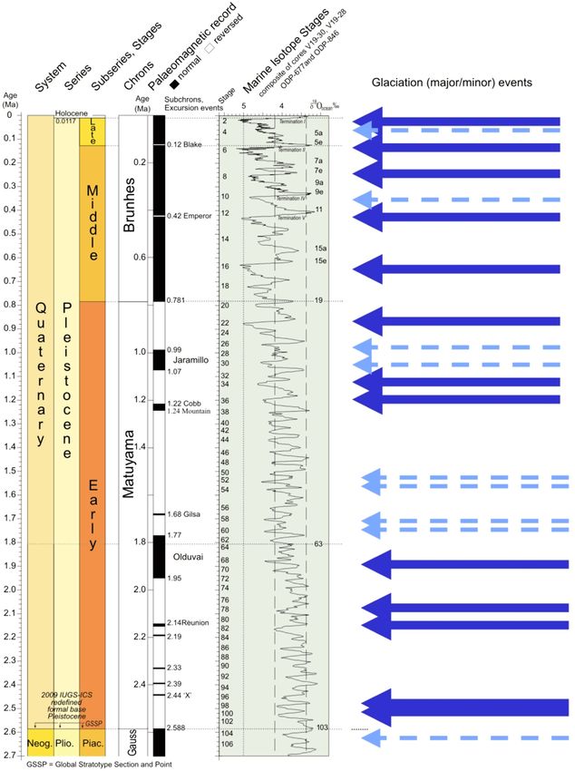
FIGURE 4.1
Distribution of major and minor glaciations through Quaternary time.
 Extract from Global Correlation table by Gibbard, P.L., Cohen, K.M., 2008. Global chronostratigraphical correlation table for the last
                                                                                           2.7 million years. Episodes 31, 243 247.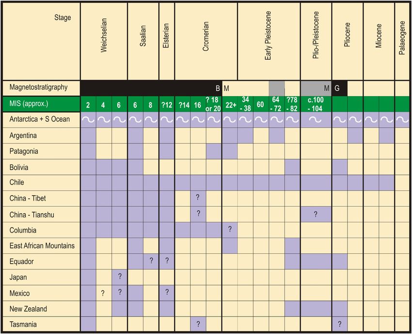
4.4 PLIO-PLEISTOCENE GLACIATION                        81

FIGURE 4.2
Cenozoic worldwide glaciation through time, showing the relative importance of glaciations as broadly indicated
by the number of literature records cited in the compilation by Ehlers and Gibbard (2004a,b,c). MIS, Marine
Isotope Stages.

the Pliocene and onwards to the present day in the mountains. Likewise, in Norway, its adjacent
offshore and the neighbouring Barents Sea, glaciation is recorded from the Early Miocene, Early
Pliocene, and Plio-Pleistocene.
    A core from c. 75 N latitude in the Norwegian-Greenland Sea off East Greenland contains
IRD with at least some likely from glaciers rather than sea ice, from c. 38 to 30 Ma (Late
Eocene to Oligocene). Certain characteristics of this debris point to an East Greenland source
and exclude Svalbard, the next-nearest land mass (Eldrett et al., 2007). This IRD may represent
isolated mountain glaciers or more extensive ice-sheet cover (Alley et al., 2010). By the Late
Miocene, inland ice sheets were periodically present in Greenland, especially in the mountain-
ous east, with ice reaching the sea in SE Greenland, whilst contiguous ice sheets have occurred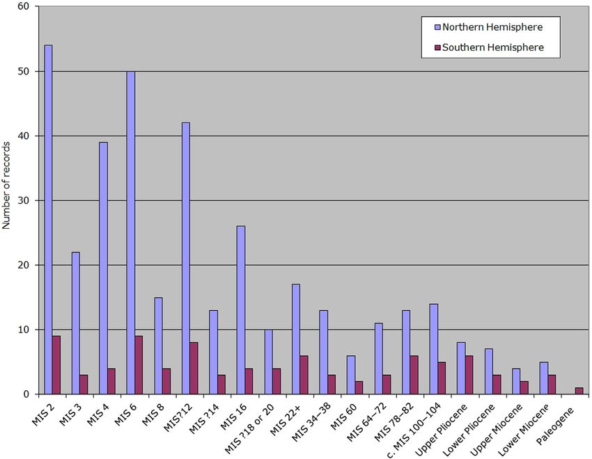
82       CHAPTER 4 QUATERNARY GLACIATIONS AND CHRONOLOGY

FIGURE 4.3
Overview map showing the regions covered by the INQUA project ‘Extent and Chronology of Glaciations’. Each
dot on the map represents one contribution to the project.
             Adapted from Ehlers, J., Gibbard, P.L., 2003. Extent and chronology of glaciations. Quat. Sci. Rev. 22, 1561 1568.

since the earliest Pleistocene (c. 2.3 million years) (Funder, personal communication). In the
eastern Rockies of the United States a much shorter glacial sequence occurs. Here
Plio-Pleistocene-aged till is known from Montana, North Dakota, and California. On Mount
Kilimanjaro, in East Africa the first glaciation is recognized at c. 2.0 million years (?c. MIS 68).
In Europe glaciation before the Middle Pleistocene is represented only by ice-rafted material, outside
the mountain regions (e.g., in the Netherlands, lowland Germany, European Russia, and Britain).
Substantial glaciation of the Baltic region late in the Early Pleistocene is indicated by erratic materi-
als in the Netherlands (1 1.2 Ma; ?MIS 34 36). Glaciation is also established in the Alps from the
Plio-Pleistocene.
    In the Southern Hemisphere glaciation is much longer established, as noted above. Here the ice
already formed in the Late Eocene Early Oligocene in east Antarctica and built-up in a step-like
pattern through the Neogene. The present polar conditions were already established by the Early
Pleistocene after 2.5 Ma. A similar history is known from the piedmont areas of Argentina and
Chile, where substantial ice caps were established by 14 Ma. Widespread lowland glaciation
between 2.05 and 1.86 Ma (?c. MIS 68 78), followed by the ‘Great Patagonian Glaciation’ that
took place at 1.15 1.00 Ma (c. MIS 30 34) (Coronato and Rabassa, 2011). Further north, the ear-
liest glaciation recorded in the Bolivian Andes dates from 3.27 Ma, with extensive events at 2.2 Ma
(c. MIS 82). In Columbia the record also begins at 2.5 Ma. The earliest records in Australasia are
found in Tasmania and New Zealand from the Plio-Pleistocene (2.6 Ma: MIS 98 104; Colhoun
and Barrows, 2011). Only slightly younger is New Zealand’s oldest known glacial event
(the Porika Glaciation; Barrell, 2011).
4.4 PLIO-PLEISTOCENE GLACIATION 83 Table 4.1 Occurrence of Glaciation in Europe Through the Cenozoic Based on Numbers of Observations Presented in Contributions to the INQUA Project Extent and Chronology of Quaternary Glaciations (Ehlers and Gibbard, 2004a)
84     CHAPTER 4 QUATERNARY GLACIATIONS AND CHRONOLOGY

Table 4.2 Occurrence of Glaciation in North America Through the Cenozoic Based on
Numbers of Observations Presented in Contributions to the INQUA Project Extent and
Chronology of Quaternary Glaciations (Ehlers and Gibbard, 2004b)
4.5 THE ‘GLACIAL’ PLEISTOCENE                 85

 Table 4.3 Occurrence of Glaciation in the Rest of the World Through the Cenozoic Based on
 Numbers of Observations Presented in Contributions to the INQUA Project Extent and
 Chronology of Quaternary Glaciations (Ehlers and Gibbard, 2004c)

4.5 THE ‘GLACIAL’ PLEISTOCENE
The ‘glacial’ Pleistocene effectively began with extensive glaciation of lowland areas, particularly
around the North Atlantic region, and the intensification of global cold period (glacial) climates, in
general. Till sheets of the major glaciations during the ‘glacial Pleistocene’ are found throughout
Europe and Siberia. In northern Europe, till sheets characterize large areas of the lowlands and are
also found on the floors of the adjacent seas (Gibbard and Clark, 2011; Karabanov and Matveyev,
2011; Johansson et al., 2011; Kalm et al., 2011; Lee et al., 2011). Recent investigations have dem-
onstrated the extent to which the North Sea floor was sculpted by repeated glaciation (Graham
et al., 2011; Sejrup et al., 2015). Further south, in central and southern Europe, glacial diamicton is
86        CHAPTER 4 QUATERNARY GLACIATIONS AND CHRONOLOGY

BOX 4.2 NATURE OF THE EVIDENCE OF GLACIATION AND LIMITATIONS
The evidence of ancient glaciations is generally preserved in two ways: on land, glacial diamicton (till, tillite) and related
meltwater deposits occur in sedimentary sequences, whilst beneath the seas the main evidence occurs as waterlain
diamictons or, more frequently and far-wider distributed, as IRD carried by floating ice. In volcanically active regions,
such as the Antarctic Peninsula or Iceland, the study of glaciovolcanic sequences provides another powerful tool to
reconstruct the thickness, extension, and thermal regime of past ice sheets (Smellie et al., 2008, 2009; Geirsdóttir, 2011).
    By their nature, terrestrial glacial sedimentary sequences are fragmentary and are generally preserved where they
have been protected by later accumulations or volcanic products. Precisely where these glaciations occurred and how far
they extended is often very difficult to determine, given that the remnants of less extensive early glaciation tend to be
obliterated and mostly removed by later, more extensive advances. Although this is so in all terrestrial areas, it is
especially difficult in mountain regions where the preservation potential of older sequences rapidly diminishes with time
and subsequent glaciation. This fragmentary pattern of preservation of terrestrial glacial sequences contrasts with that in
the oceans where sequences, once deposited, remain largely unmodified for much longer periods. The only exceptions
are those sequences affected by submarine debris flows or those that were laid down on the shelves or within fjords, etc.
where later glaciation and sea-level changes can cause removal of preexisting evidence. Whilst all these points are true
for glaciations at any time during the geological history, it is particularly a problem for the reconstruction of events
during the late Neogene and Early Pleistocene. Then, glaciation was considerably less extensive than during the later
Quaternary, implying that younger glaciations may have removed much of the evidence of previous glaciations.
Nevertheless, by comparing the available Early Pleistocene glacial evidence on a global scale provides insights on the
timing, location, and minimum extent of glaciation.
    The transport of materials by floating ice is one of the principal processes by which coarse glacial sediment is
dispersed in water bodies. The occurrence of clastic sediment in ocean-bottom sediments is generally interpreted as
evidence that glaciers were sufficiently extensive to have reached the sea (i.e., tidewater glaciers). Although transport by
calved icebergs is the most common way, it is also possible for materials to be transported in ocean basins by sea ice
(Nürnberg et al., 1994; Andrews, 2000) or, although less commonly, by algae, driftwood, and the like (Gilbert, 1984;
Vogt and Parish, 2012).
    The deposits arising from both sea-ice and iceberg melting are termed ice-rafted detritus or debris (IRD). Icebergs
calved from glaciers that terminate in the sea (or lakes), especially those from temperate ice tongues, frequently include
debris that is frozen onto or within the ice body. As the ice drifts with the ocean currents and wind, its included sediment
can be transported over long distances that can exceed 1000 1500 km (Ruddiman, 1977; Bond et al., 1992; Williams
et al., 2010) within and across ocean basins. According to Dowdeswell and Murray (1990), the volume of sediment
deposited by iceberg rafting is dependent on several factors that are determined by the primary sediment source, the rate
of glacier calving, the rate of iceberg melt, the ocean surface-water temperature and factors controlling the iceberg drift
rate (cf. Benn and Evans, 2010). Icebergs can be produced in different ways, which Williams et al. (2010, p. 358 359)
summarize as follows: ‘IRD-bearing icebergs can be produced when an ice sheet reaches the edge of the continental
shelf during glacial maxima (Marshall and Koutnik, 2006), during glacial advance (McManus et al., 1999), during glacial
retreat (McManus et al., 1999), or due to instabilities in the ice sheet leading to ice-rafting like the Heinrich events of the
North Atlantic in the last glacial (Hemming, 2004)’. Because we review data of glaciation over a time scale of almost 3
million years, different production mechanisms are not differentiated, which operate on shorter time scales. Here the IRD
records are simply taken as evidence for an ice sheet that reaches the coastline.
    In subpolar regions, the occurrence of coarse-grained ( .63 µm) sediment and clasts in open-ocean sediments is
generally attributed to iceberg transport and melting, and provides indirect evidence of terrestrial glaciation (Andrews,
2000; St. John, 2008; Polyak et al., 2010). In polar regions, melting of sea ice usually contributes fine-grained sediment,
but occasionally also coarse-grained sediment, to the geological record (Nürnberg et al., 1994; Müller and Knies, 2013).
Fine-grained sediment that occurs in suspension on shallow shelves can be incorporated in sea ice during ice-freeze-up
(frazil-ice formation) (Kempema et al., 1989; Nürnberg et al., 1994; Polyak et al., 2010). In addition, anchor ice, which
forms on the sea-floor during super-cooled conditions, can incorporate and distribute any sediment (Reimnitz et al.,
1987; Polyak et al., 2010). Wind-blown sand also contributes to the sediments carried by sea ice and icebergs (Atkins
and Dunbar, 2009). The sediment transported by sea ice cannot be seen as direct evidence of glaciation on land, and
                                                                                                                  (Continued )
4.5 THE ‘GLACIAL’ PLEISTOCENE 87
BOX 4.2 NATURE OF THE EVIDENCE OF GLACIATION AND
LIMITATIONS (CONTINUED)
makes the distinction between sea ice- and iceberg-transport processes challenging yet essential for palaeoenvironmental
interpretations.
Based on grain size alone, it is often not possible to attribute a small coarse-grained fraction in deep-sea sediments to
either sea ice or iceberg transport in the geological record (St. John, 2008). Using surface textures of sand-sized quartz
grains, St. John (2008) demonstrated the presence of sea ice and iceberg-derived sediment in the Arctic Ocean since the
Eocene. Chemical fingerprinting of iron oxide sand grains illustrated periods with perennial sea ice possibly already in
the Middle Eocene (c. 47.5 Ma; Darby, 2014) and in the Late Miocene (Darby, 2008).
restricted to the mountains and piedmonts (Calvet et al., 2011; Giraudi, 2011; Nývlt et al., 2011;
Urdea et al., 2011; Van Husen, 2011; Woodward and Hughes, 2011).
In northern Europe and Siberia, widespread lowland glaciation began in the early Middle
Pleistocene shortly after the Brunhes Matuyama palaeomagnetic reversal (0.78 Ma). The phases
represented include the Donian (Narevian, Sanian, MIS 16, ‘Cromerian Complex’ Stage), Elsterian
(Okan, MIS 12), Saalian (Dniepr/Moscovian and Vologda, MIS 6, 8, and 10), and the Weichselian
Stage (Valdaian, MIS 4 2) (e.g., Astakhov et al., 2015). More limited glaciation may have
occurred in the circum-Baltic region during the latest Early Pleistocene (MIS 22 and 20). The
evidence for Early Pleistocene glaciations is restricted in the region to Latvia (Zelčs et al., 2011),
Poland (Marks, 2011), and possibly Lithuania (Guobytė and Satkūnas, 2011), although current
research suggests pre-Cromerian glaciation could have extended into central Jylland, Denmark
(Houmark-Nielsen, 2011). Although Early Pleistocene glaciation has been demonstrated from ice-
rafting in the northern North Sea (Ottesen et al., 2014) and a c.1.1 Ma till from offshore Norway
(Sejrup et al., 1995), early Middle Pleistocene glaciation has not yet been recorded from the North
Atlantic and offshore Norway (where the earliest Middle Pleistocene glaciation occurred B0.6 Ma,
possibly during MIS 12; Sejrup et al., 1995), it is certainly present in Denmark, the Baltic region,
and European Russia. The first evidence of major lowland expansion of the Fennoscandian ice
sheet during the Menapian Stage potentially correlates with the 1.1. Ma Fedje Glaciation of Sejrup
et al. (1995).
In the Italian Dolomites, glaciation became established in MIS 22 (Muttoni et al., 2003).
Comparable evidence is also found north of the Alps in Switzerland and southern Germany
(Fiebig et al., 2011). The oldest glaciation identified in the Pyrenees is of late Cromerian age
(MIS 16 or 14) (Calvet, 2004). In North America, widespread lowland glaciation is first seen during
MIS 22 or 20 (Barendregt and Duk-Rodkin, 2011; Duk-Rodkin and Barendregt, 2011). Subsequently,
major ice sheets repeatedly extended over large regions of the continent during the Middle
Pleistocene pre-Illinoian events MIS 16, 12, 8, and 6 (Illinoian s.s.) and the Late Pleistocene
MIS 4 2 (Wisconsinan). In Mexico, the oldest moraines on volcanoes have been dated to
205 175 ka, corresponding to advances during the Illinoian Stage (MIS 6) (Vásquez-Selem and
Heine, 2011). Evidence from East Greenland suggests that the southern dome of the ice sheet may
have almost disappeared during the Eemian Stage interglacial (c. MIS 5e). However, dating of the
basal ice in the Dye 3 ice core has shown that glacial ice has been present over this locality since at
least MIS 11 (Funder et al., 2011).88 CHAPTER 4 QUATERNARY GLACIATIONS AND CHRONOLOGY
According to Chinese investigations, glaciation of Tibet and Tianshu is not recorded before the
Middle Pleistocene, of which the MIS 12 glaciation was the most extensive. Four discrete
Pleistocene glaciations have been identified on the Qinghai-Tibetan Plateau and the bordering
mountains. These major Pleistocene glaciations are equated to MIS 18 16, 12, 6, and 4 2. This
apparently delayed glaciation of the Himalayan chain might reflect late uplift of high Asia. The
Kunlun Glaciation (MIS 18 16) was the most extensive. Subsequent glaciations have been succes-
sively more reduced, probably caused by increasingly arid climates resulting from the progressive
Quaternary uplift of the plateau (Zhou Shangzhe et al., 2011). By contrast, Kuhle (2011) maintains
that the last glaciation was most extensive since he envisages an ice sheet covered Tibet. However,
this is an increasingly minority view, particularly the concept that the Qinghai-Tibetan Plateau was
almost entirely covered by an ice sheet. The majority opinion is that Pleistocene glaciations over
the Qinghai-Tibetan Plateau were much more restricted (Klinge and Lehmkuhl, 2004; Lehmkuhl
and Owen, 2005). As these authors argue, it is now generally well established that a large ice sheet
did not cover the Tibetan Plateau. This controversy serves to illustrate the fact that in several
regions debate over the glacial history continues.
As in the Northern Hemisphere circum-Atlantic region, glaciation increased in intensity after
800 ka throughout the South American Andes. In the northern Andes there is evidence of glacial
deposition from the Early Pleistocene in Venezuela and Colombia (e.g., Helmens, 2011). In the
southern Andes, the Late Pleistocene saw glaciation that was less extensive than during the Early
Pleistocene events (Coronato and Rabassa, 2011; Martı́nez et al., 2011; Harrison and Glasser,
2011). Both easternmost Tierra del Fuego and the Falkland Islands are thought by some to have
remained largely unglaciated throughout the Pleistocene (Clapperton, 1993), though there are traces
of glacial scouring (Ehlers and Gibbard, 2008). In Australasia, following a 1 Ma break, the glacial
record resumes in MIS 12, followed by MIS 6, 4, and 3. In Tasmania, the earliest Pleistocene ice
advances are thought to have been about 1 million years old but may be older. Middle Pleistocene
ice advances occurred during MIS 10, 8, and 6 (Colhoun and Barrows, 2011). The presence of
glaciations in this area during MIS 8, indicated by cosmogenic exposure dating, is interesting
because a record of glaciation during this interval is absent from many other parts of the world.
In Africa, glaciations were restricted to the East African mountains including Mount Kilimanjaro,
Mount Kenya, and the High Atlas, where the major glacial events appear to have been broadly syn-
chronous with those elsewhere beginning in MIS 12. In Asia, the mountains of Japan were glaci-
ated (Sawagaki and Aoki, 2011), as well as the high mountains of Taiwan and Indonesia (Böse and
Hebenstreit, 2011; Prentice et al., 2011).
The repeated records for the occurrence of Middle Pleistocene glaciations during MIS 16 and
MIS 12 throughout the world are striking, whereas the absence of evidence for glaciations during
MIS 18, and to a lesser extent MIS 14, implies that later glaciations were more extensive and there-
fore probably destroyed evidence for these events. However, it is also possible that some of these
glacial deposits have been inadequately differentiated owing to the limitations of current dating
techniques. Lack of precision for dating terrestrial Middle Pleistocene sequences leaves some uncer-
tainty until better dating techniques become available. It is likely that the application of multiple
methods of developing glacial geochronologies will be required in order to gain greater precision,
and, crucially, to test the validity of the various dating techniques (cf. discussion in Heine, 2011a,b).
It therefore appears from direct evidence that until c. 1.2 Ma the cold periods (glacials) were
not regularly cold and long enough to allow ice-sheet development on a continental scale, outside4.5 THE ‘GLACIAL’ PLEISTOCENE 89
mountain or polar regions, and that the most extensive glaciations in the Quaternary (c. 5 6 inter-
vals) began in the last 900 kiloyears (c. MIS 22 to present) in the Northern Hemisphere (Head and
Gibbard, 2015a). In contrast, southern hemispheric glaciation is a much longer established phenom-
enon with substantial glaciation already a regular occurrence in the Tertiary.
The timing of the increased intensity of glaciation corresponds closely to observations around
the world concerning the increase in relief generation. For example, it has been estimated that in
the Swiss Alps, relief was increased 1250 6 650 m in the last c.1 Ma (Häuselmann et al., 2007).
Recent observations in the North Alpine Foreland indicate that thick glaciofluvial units, dating pre-
dominantly from the Penultimate Glacial Maximum (PGM, i.e., MIS 6a; cf. Box 4.3), overlie
intensely eroded and overdeepened Miocene bedrock. This intense erosion probably occurred dur-
ing Early Pleistocene major glaciations, based on luminescence ages (Salcher et al., 2015). Similar
scale erosion occurred in southern Norway, where incision of ancient ‘palaeic’ surfaces to a depth
of as much as 2 km occurred (Reusch, 1901; Lidmar-Bergström et al., 2000). This incision has
BOX 4.3 ASYNCHRONEITY OF GLOBAL GLACIATION
The term Last Glacial Maximum (LGM) refers to the period when global ice volume last reached its maximum and
eustatic sea levels were at their lowest, between 27.540 and 23.340 ka (Hughes and Gibbard, 2015). However, the
boundaries of the interval are ill-defined and therefore the term and acronym have no formal stratigraphical basis. As
Hughes et al. (2013) have shown, increasingly evidence from terrestrial records demonstrates that the LGM is poorly
represented since many sequences show a diachronous response to global climate changes during the last glacial cycle.
For example, glaciers and ice sheets reached their maximum extents at widely differing times in different places. In fact,
most terrestrial records display spatial variation in response to global climate fluctuations, and changes recorded on land
are often diachronous, asynchronous, or both, leading to difficulties in global correlation (Hughes and Gibbard, 2015).
For this reason it is recommended that the term LGM be considered an event-based rather than a time-based unit.
The LGM exemplifies the value of adopting an event-based classification for glacial sequences (i.e., a scheme in
which boundaries can be diachronous in nature). However, in spite of this utility, glacial maximum (GM) events have
not been formally recognized for earlier glaciations. Nevertheless, Margari et al. (2014) mentioned that for Marine
Isotope Stage (MIS) 6 ‘eustatic sea level records and glacial geological evidence suggest that ice sheets expanded, with
global ice-volume reaching its maximum extent toward the end of MIS 6’, i.e., B140 136 ka (within MIS 6a; ‘PGM’ or
‘Penultimate Glacial Maximum’, sensu Stirling et al., 1998); or c. 149 140 ka (Railsback et al., 2014, 2015b).
The penultimate glaciation (c. 135 185 ka) corresponds to MIS 6, the Illinoian glaciation in North America, the
Saalian glaciation in Europe, and equivalents elsewhere. In Europe it was characterized by two major ice advances: the
more extensive Drenthe, followed by the Warthe. No major interstadial warming occurs within the Saalian, and this is in
concert with the lack of organic deposits and absence of palaeosols in northern Europe during the interval between the
Drenthe and the Warthe Stadials (Ehlers et al., 2011b). After c. 150 ka, glacial geological evidence suggests that ice
sheets expanded, with global ice volume reaching its maximum extent towards the end of MIS 6, reflecting the growth of
the Late Illinoian ice sheet in North America (e.g., Curry et al., 2011; Syverson and Colgan, 2011). In Europe, the
Warthe ice advances were less extensive than the Drenthe (Ehlers, 2011), but that may have been compensated for by ice
expansion in Russia and Siberia (e.g., Astakhov, 2004). Compared to the Last Glacial Maximum (LGM), late MIS 6 (i.e.,
MIS 6a) was characterized by overall larger ice sheets (Margari et al. 2014), although modelling by Colleoni et al.
(2016) suggests that the Laurentide Ice Sheet might have been smaller than during the PGM at 140 ka.
Previous glaciations also show GM peaks of similar duration, such as within MIS 12a (B437 430 ka) and MIS 16a
(B640 625 ka), where marine isotope substage divisions follow Railsback et al. (2015a,b). As Hughes et al. (2013)
noted, one of the major implications of the asynchroneity of maximum glacial extent apparent in the last glacial cycle is
the possibility that this pattern of asynchroneity of GM extent might have been repeated during earlier glaciations,
particularly during the Middle Pleistocene (Ehlers et al., 2011a,b). If this occurred it could explain why some glaciations
are represented in one region of the world, whilst apparently being absent elsewhere.90 CHAPTER 4 QUATERNARY GLACIATIONS AND CHRONOLOGY
been attributed to the opening of the Atlantic Ocean and accompanying crustal unloading.
However, Medvedev and Hartz (2015) have concluded that 0.8 km uplift of rocks and up to a
0.5 km rise of local topography resulted from fluvial and glacial erosion as a consequence of
climatic deterioration during the Quaternary. Champagnac et al. (2014) also consider that cold
climates, accompanied by glacial and periglacial erosion, are more likely to have caused increase
and/or decrease in relief. They attribute this to the related physical erosional processes being highly
nonuniform in space and time and, equally, the sensitivity of these processes to minor climatic
changes. They conclude that the great intensity of erosion under glacial and periglacial conditions
suggests the overall observation that cold and variable Quaternary climate has resulted in an
increase in relief at the global scale.
The application of numerical dating is increasingly demonstrating the potential asynchroneity of
glacial extent on a global scale (Box 4.3). Whilst the differing timing of ice lobes at a local scale
has been known for decades, evidence that the maximum extents of major ice sheet margins may
differ by as much as tens of thousands of years is beginning to be established. Contrasts between
different hemispheres, and within them, different environmental settings, appear to occur. Judging
from the evidence from the Last Glaciation (see Section 4.6), such differences appear to result
from the differing regional geographical situation, variations in the supply of precipitation, regional
temperature variation, differing ocean and atmospheric circulation, etc. (cf. Margari et al., 2014).
4.6 LAST GLACIATION
The term Last Glacial Maximum or LGM is widely accepted as referring to the maximum global
ice volume during the last glacial cycle corresponding with the trough in the marine isotope record
centred on c. 18 14C ka BP (Martinson et al., 1987) and the associated global eustatic sea-level low
also dated to 18 14C ka BP (Yokoyama et al., 2000). It has also been assigned chronozone
status (23 19 or 24 18 ka cal BP dependent on the dating applied) by Mix et al. (2001) who
consider the event should be centred on the calibrated date at 21 ka cal BP (i.e., LGM sensu stric-
to). However, other research on global sea-level minima places the global ice maximum slightly
earlier at between 26 and 21 ka (Peltier and Fairbanks, 2006). A recent paper by Hughes and
Gibbard (2015) combined the evidence from marine cores with that from ice cores on land to
define the LGM. Unlike marine sediment records which accumulate slowly and can be affected by
bioturbation, ice-core records have a much higher resolution and provide evidence of climate
changes on a year-by-year basis. Hughes and Gibbard (2015) identified the period between 27,540
and 23,340 years ago corresponding with Greenland Stadial 3 in the Greenland ice-core record, as
the best candidate interval for its formal stratigraphical definition (Fig. 4.4). This interval was char-
acterized by the largest global ice volume, the lowest global sea levels and the greatest atmospheric
dust flux in both hemispheres and some of the coldest temperatures of the last ice age. The end of
the LGM event is marked by evidence for a large discharge of icebergs into the North Atlantic
Ocean (Heinrich Event 2) which coincided with the onset of the collapse of the Laurentide Ice
Sheet at c. 24 ka, together with other ice sheets in the North Atlantic region.
During the LGM, the extent of the glaciation of the Southern Hemisphere differed very little
from that of the Pleistocene glacial maximum (GM). Glaciers in Antarctica still reached the shelfFIGURE 4.4 The proposed definition of the global Last Glacial Maximum (LGM) within Greenland Stadial 3 by Hughes and Gibbard (2015). The top two diagrams are the oxygen isotope (Andersen et al., 2006) and dust concentration (Ruth et al., 2007) records from the NGRIP core. The NGRIP core is on the GICC05 age model. The bottom two diagrams are the dust flux (Lambert et al., 2012) and deuterium-derived temperature (Jouzel et al., 2007) records from EPICA, Antarctica. The EPICA records are both on the EDC3 age model. H2 and H3 are Heinrich Events when large icebergs were discharged into the North Atlantic Ocean.
92       CHAPTER 4 QUATERNARY GLACIATIONS AND CHRONOLOGY

edge, and on New Zealand, Tasmania, and in South America the glacier tongues were only slightly
smaller than during earlier events (Andersen et al., 1999; Coronato et al., 2004a,b). On mainland
Australia, local mountain glaciation occurred (Barrows et al., 2001, 2002). It seems that the LGM
in the Southern Hemisphere began earlier than in the Northern Hemisphere, probably at around
27 ka (Suggate and Almond, 2005). The high mountains of East Africa were glaciated (Osmaston,
2004). There is only evidence of minor glaciers in South Africa (Hall, 1994; Mills et al., 2009). It
must be borne in mind that South Africa is located relatively close to the equator to the North.
Were it in the Northern Hemisphere, Cape Town would be situated at the same latitude as Atlanta
in Georgia, USA, or, if placed relative to the European ice sheet, it would be south of Tunis.
     During the LGM, ice in many parts of the Northern Hemisphere reached an extent very similar
to the Quaternary GM. In North America, the differences are very small. Again, most parts of
Canada were ice-covered, including the shelf areas (Dyke, 2004). It is the same in Greenland
(Funder et al., 2004; Weidick et al., 2004).
     In Europe, however, the situation was different. New evidence suggests that the North Sea was not
fully glaciated during the Weichselian GM, but slightly earlier (Sejrup et al., 1994, 2009; Carr, 2004).
An ice sheet covered the Barents Sea and extended well into the Kara Sea but hardly touched the
Russian mainland (Svendsen et al., 1999, 2004a,b). The ice sheet was markedly smaller than during the
Quaternary GM. It seems that the northward drainage of the Ob and Yenisei rivers was not impeded
(Lambeck et al., 2006). In glaciated mountain areas outside the major ice sheets, such as in Italy and
Greece, the maximum Middle Pleistocene glaciations were much greater than the local last glacial
maxima (Giraudi, 2004, 2011; Woodward et al., 2004; Woodward and Hughes, 2011). This is attributed
to a change in equilibrium-line altitude. Features on the floor of the Arctic Ocean seem to suggest that
the Arctic basin was once covered by a one-kilometre-thick, flowing ice shelf derived from large ice
sheets in eastern Siberia, Arctic Canada, and the Barents Sea (Polyak et al., 2001; Domack, 2016).
     There were major ice sheets or mountain glacier systems in the Siberian mountains further to
the east. Because of the lack of detailed investigations to date, in most cases it is not possible
to differentiate between the extent of the LGM and earlier glaciations (Brigham-Grette et al., 2003;
Glushkova, 2011). Likewise, the age and extent of the glaciers in Iran and the mountain ranges and
high plateaux further to the east, and especially the extent of glaciation on the Tibetan Plateau, are
still matters of debate (Owen et al., 2003; Klinge and Lehmkuhl, 2004; Kuhle, 2004; Lehmkuhl
and Owen, 2005; Abramowski et al., 2006). In contrast, the small mountain glaciers of Japan
are well mapped and dated and, unlike those of the adjoining Asian mainland, the maximum
ice advance of the last glaciation occurred in MIS 4 (Sawagaki et al., 2004). The same date for the
maximum extent is found in New Zealand (Suggate, 1990; Preusser et al., 2005).
     Whilst the LGM was a major ice advance around the world, it is now clear that glaciers reached
their true maximum Late Pleistocene extent at different times during the last glacial cycle (Hughes
et al., 2013). Whilst this finding is not new for mid-latitude mountain glaciers (cf. Gillespie and
Molnar, 1995), the degree of complexity and variability both spatially and temporally revealed is
striking. In the global review by Hughes et al. (2013), it is clear that in many areas glaciers reached
their maximum extent early in the last glacial cycle in MIS 3, 4, or even 5, well before the global
LGM in MIS 2. Furthermore, this is not only a phenomenon that is restricted to mid-latitude moun-
tain glaciers but it is also seen in certain sectors of the large continental ice sheets.
     The Laurentide Ice Sheet maximum corresponds to the global LGM in MIS 2 and dominates
the marine oxygen isotope and sea-level records. In contrast, the Barents-Kara ice sheet in northern
REFERENCES 93
Eurasia reached its maximum extent during MIS 4, as did the western sectors of the
Fennoscandinavian Ice Sheet and the northern sector of the Cordilleran Ice Sheet. In Asia, the vast
majority of mountain glaciers reached their maximum positions before MIS 2, in MIS 5, 4, and 3.
The same appears to be valid for New Zealand and southeast Australia and parts of South America.
The East Antarctic Ice Sheet also appears to have been out-of-synchronization with global ice
volume, retreating from its maximum extent before MIS 2. Thus the concept of the global LGM
needs to be carefully considered in terms of meaning and significance (Hughes et al., 2013; Hughes
and Gibbard, 2015). The findings from the last glacial cycle are also likely to be true for all other
glacial cycles and further research is required to decipher the relationship between global glacier
activity and other records of global change such as the marine isotope record.
4.7 SUMMARY
The Quaternary is synonymous with extensive glaciation of Earth’s mid- and high-latitudes.
Although there were local precursors, significant glaciation began in the Oligocene in eastern
Antarctica. It was followed by glaciation in mountain areas through the Miocene (in Alaska,
Greenland, Iceland, and Patagonia), later in the Pliocene (e.g., in the Alps, the Bolivian Andes, and
possibly in Tasmania) and in the earliest Pleistocene (New Zealand, Iceland, and Greenland).
Today evidence from both the land and the ocean floors demonstrates that the major continental
glaciations, outside the polar regions, rather than occurring throughout the 2.6 Ma of the
Quaternary, were markedly restricted to the last 1 Ma 800 ka or less. MIS 22 (c. 870 880 Ma)
included the first of the ‘major’ worldwide events with substantial ice volumes that typify the later
Pleistocene glaciations (i.e., MIS 16, 12, 10, 6, 4 2).
REFERENCES
Abramowski, U., Bergau, A., Seebach, D., Zech, R., Glaser, B., Sosin, P., et al., 2006. Pleistocene glaciations
of Central Asia: results from 10Be surface exposure ages of erratic boulders from the Pamir (Tajikistan),
and the Alay-Turkestan range (Kyrgyzstan). Quat. Sci. Rev. 25, 1080 1096.
Alley, R.B., Andrews, J.T., Brigham-Grette, J., Clarke, G.K.C., Cuffey, K.M., Fitzpatrick, J.J., et al., 2010.
History of the Greenland ice sheet: paleoclimatic insights. Quat. Sci. Rev. 29, 1728 1756.
Andersen, B.G., Denton, G.H., Lowell, T.V., 1999. Glacial geomorphologic maps of Llanquihue Drift in the
area of the southern Lake District, Chile. Geogr. Ann. 81A, 155 160.
Andersen, K.K., Svensson, A., Johnsen, S.J., Rasmussen, S.O., Bigler, M., Röthlisberger, R., et al., 2006. The
Greenland Ice Core Chronology 2005, 15 42 ka. Part 1: constructing the time scale. Quat. Sci. Rev. 25,
3246 3257.
Andrews, J.T., 2000. Icebergs and iceberg rafted detritus (IRD) in the North Atlantic: facts and assumptions.
Oceanography 13, 100 108.
Astakhov, V., 2004. Pleistocene ice limits in Russian northern lowlands. In: Ehlers, J., Gibbard, P.L. (Eds.),
Quaternary Glaciations—Extent and Chronology. Part I, Europe. Developments in Quaternary Science,
vol. 2. Elsevier, Amsterdam, pp. 309 319.94 CHAPTER 4 QUATERNARY GLACIATIONS AND CHRONOLOGY
Astakhov, V., Shkatova, V., Zastrozhnov, A., Chuyko, M., 2015. Glaciomorphological map of the Russian
Federation. Quat. Intl. ,http://dx.doi.org/10.1016/j.quaint.2015.09.02/..
Atkins, C.B., Dunbar, G.B., 2009. Aeolian sediment flux from sea ice into Southern McMurdo Sound,
Antarctica. Glob. Planet. Change 69, 133 141.
Barendregt, R.W., Duk-Rodkin, A., 2011. Chronology and extent of late Cenozoic ice sheets in North
America: a magnetostratigraphical assessment. In: Ehlers, J., Gibbard, P.L., Hughes, P.D. (Eds.),
Quaternary Glaciations—Extent and Chronology—A Closer Look. Developments in Quaternary Sciences,
vol. 15. Elsevier, Amsterdam, pp. 419 426.
Barrell, D.J.A., 2011. Quaternary glaciers of New Zealand. In: Ehlers, J., Gibbard, P.L., Hughes, P.D. (Eds.),
Quaternary Glaciations—Extent and Chronology—A Closer Look. Developments in Quaternary Sciences,
vol. 15. Elsevier, Amsterdam, pp. 1047 1064.
Barrows, T.T., Stone, J.O., Fifleld, L.K., Cresswell, R.G., 2001. Late Pleistocene glaciation of the Kosciuszko
Massif, Snowy Mountains, Australia. Quat. Res. 55, 179 189.
Barrows, T.T., Stone, J.O., Fifield, L.K., Cresswell, R.G., 2002. The timing of the Last Glacial Maximum in
Australia. Quat. Sci. Rev. 21, 159 173.
Bartoli, G., Sarnthein, M., Weinelt, M., Erlenkeuser, H., Garbe-Schönberg, D., Lea, D., 2005. Final closure of
Panama and the onset of northern hemisphere glaciation. Earth Planet. Sci. Lett 237, 33 44.
Benn, D.I., Evans, D.J.A., 2010. Glaciers and Glaciation. second ed. Hodder Education, London, 802 pp.
Bond, G., Heinrich, H., Broecker, W., Labeyrie, L., McManus, J., Andreasen, D., et al., 1992. Evidence for massive
discharges of icebergs into the North-Atlantic Ocean during the Last Glacial period. Nature 360, 245 249.
Böse, M., Hebenstreit, R., 2011. Late Pleistocene and Early Holocene Glaciations in the Taiwanese high
mountain ranges. In: Ehlers, J., Gibbard, P.L., Hughes, P.D. (Eds.), Quaternary Glaciations—Extent and
Chronology—A Closer Look. Developments in Quaternary Sciences, vol. 15. Elsevier, Amsterdam,
pp. 1003 1012.
Brigham-Grette, J., Gualtierie, L.V., Glushkova, O.Y., Hamilton, T.D., Mostoller, D., Kotov, A., 2003.
Chlorine-36 and 14C chronology support a limited last glacial maximum across central Chukotka, north-
eastern Siberia, and no Beringian ice sheet. Quat. Res. 59, 386 398.
Calvet, M., 2004. The Quaternary glaciations of the Pyrenees. In: Ehlers, J., Gibbard, P.L. (Eds.), Quaternary
Glaciations—Extent and Chronology. Part I, Europe. Developments in Quaternary Science, vol. 2.
Elsevier, Amsterdam, pp. 119 128.
Calvet, M., Delmas, M., Gunnell, Y., Braucher, R., Bourlès, D., 2011. Recent advances in research on
Quaternary glaciations in the Pyrenees. In: Ehlers, J., Gibbard, P.L., Hughes, P.D. (Eds.), Quaternary
Glaciations—Extent and Chronology—A Closer Look. Developments in Quaternary Sciences, vol. 15.
Elsevier, Amsterdam, pp. 127 139.
Carr, S.J., 2004. The North Sea basin. In: Ehlers, J., Gibbard, P.L. (Eds.), Quaternary Glaciations—Extent and
Chronology, Part I: Europe. Developments in Quaternary Science, vol. 2a. Elsevier, Amsterdam,
pp. 261 270.
Champagnac, J.D., Valla, P.G., Herman, F., 2014. Late-Cenozoic relief evolution under evolving climate: a
review. Tectonophysics 614, 44 65.
Cita, M.B., Gibbard, P.L., Head, M.J., The Subcommission on Quaternary Stratigraphy, 2012. Formal ratifica-
tion of the base Calabrian Stage GSSP (Pleistocene Series, Quaternary System). Episodes 35 (3),
388 397.
Clapperton, C., 1993. Nature and environmental changes in South America at the Late Glacial Maximum.
Palaeogeogr. Palaeoclimatol. Palaeoecol. 101, 189 208.
Colhoun, E.A., Barrows, T.T., 2011. The glaciation of Australia. In: Ehlers, J., Gibbard, P.L., Hughes, P.D.
(Eds.), Quaternary Glaciations—Extent and Chronology—A Closer Look. Developments in Quaternary
Sciences, vol. 15. Elsevier, Amsterdam, pp. 1037 1045.REFERENCES 95
Colleoni, F., Wekerle, C., Näslund, J.-O., Brandefelt, J., Masina, S., 2016. Constraint on the penultimate gla-
cial maximum Northern Hemisphere ice topography (B140 kyrs BP). Quat. Sci. Rev. 137, 97 112.
Coronato, A., Rabassa, J., 2011. Pleistocene glaciations in southern Patagonia and Tierra del Fuego. In: Ehlers,
J., Gibbard, P.L., Hughes, P.D. (Eds.), Quaternary Glaciations—Extent and Chronology—A Closer Look.
Developments in Quaternary Sciences, vol. 15. Elsevier, Amsterdam, pp. 715 727.
Coronato, A., Martı́nez, O., Rabassa, J., 2004a. Glaciations in Argentine Patagonia, southern South America.
In: Ehlers, J., Gibbard, P.L. (Eds.), Quaternary Glaciations—Extent and Chronology, Part III: South
America, Asia, Africa, Australasia, Antarctica. Developments in Quaternary Science, vol. 2c. Elsevier,
Amsterdam, pp. 49 67.
Coronato, A., Meglioli, A., Rabassa, J., 2004b. Glaciations in the Magellan Straits and Tierra del Fuego, south-
ernmost South America. In: Ehlers, J., Gibbard, P.L. (Eds.), Quaternary Glaciations—Extent and
Chronology, Part III: South America, Asia, Africa, Australasia, Antarctica. Developments in Quaternary
Science, vol. 2c. Elsevier, Amsterdam, pp. 45 48.
Curry, B.B., Grimley, D.A., McKay III, E.D., 2011. Pleistocene Glaciations in Illinois. In: Ehlers, J., Gibbard,
P.L., Hughes, P.D. (Eds.), Quaternary Glaciations—Extent and Chronology—A Closer Look.
Developments in Quaternary Sciences, vol. 15. Elsevier, Amsterdam, pp. 447 462.
Darby, D.A., 2008. Arctic perennial ice cover over the last 14 million years. Paleoceanography. 23, PA1S07,
,http://dx.doi.org/10.1029/2007PA001479..
Darby, D.A., 2014. Ephemeral formation of perennial sea ice in the Arctic Ocean during the middle Eocene.
Nat. Geosci. 7 (3), 210 213.
De Schepper, S., Gibbard, P.L., Salzmann, U., Ehlers, J., 2014. A global synthesis of the marine and terrestrial
evidence for glaciation during the Pliocene Epoch. Earth-Sci. Rev. 135, 83 102.
Domack, E., 2016. A great Arctic ice shelf. Nature 530, 163 164.
Dowdeswell, J.A., Murray, T., 1990. Modelling rates of sedimentation from icebergs. Geol. Soc. Lond.,
Special Publications 53 (1), 121 137.
Duk-Rodkin, A., Barendregt, R.W., 2011. Stratigraphical record of glacials/interglacials in Northwest Canada.
In: Ehlers, J., Gibbard, P.L., Hughes, P.D. (Eds.), Quaternary Glaciations—Extent and Chronology—A
Closer Look. Developments in Quaternary Sciences, vol. 15. Elsevier, Amsterdam, pp. 661 698.
Dyke, A., 2004. An outline of North American deglaciation with emphasis on central and northern Canada.
In: Ehlers, J., Gibbard, P.L. (Eds.), Quaternary Glaciations—Extent and Chronology, Part II: North
America. Developments in Quaternary Science, vol. 2b. Elsevier, Amsterdam, pp. 1 7.
Ehlers, J., 2011. Das Eiszeitalter. Springer, Heidelberg, 363 pp.
Ehlers, J., Gibbard, P.L., 2003. Extent and chronology of glaciations. Quat. Sci. Rev. 22, 1561 1568.
Ehlers, J., Gibbard, P.L. (Eds.), 2004a. Quaternary Glaciations—Extent and Chronology, Part I: Europe.
Developments in Quaternary Science, vol. 2a. Elsevier, Amsterdam.
Ehlers, J., Gibbard, P.L. (Eds.), 2004b. Quaternary Glaciations—Extent and Chronology, Part II: North
America. Developments in Quaternary Science, vol. 2b. Elsevier, Amsterdam.
Ehlers, J., Gibbard, P.L. (Eds.), 2004c. Quaternary Glaciations—Extent and Chronology, Part III: South
America, Asia, Africa, Australasia, Antarctica. Developments in Quaternary Science, vol. 2c. Elsevier,
Amsterdam.
Ehlers, J., Gibbard, P.L., 2008. Extent and chronology of Quaternary glaciation. Episodes 31, 211 218.
Ehlers, J., Gibbard, P.L., Hughes, P.D. (Eds.), 2011a. Quaternary Glaciations—Extent and Chronology—A
Closer Look. Developments in Quaternary Science, vol. 15. Elsevier, Amsterdam, 1108 pp.
Ehlers, J., Gibbard, P.L., Hughes, P.D., 2011b. Introduction. In: Ehlers, J., Gibbard, P.L., Hughes, P.D. (Eds.),
Quaternary Glaciations—Extent and Chronology—A Closer Look. Developments in Quaternary Science,
vol. 15. Elsevier, Amsterdam, pp. 1 14.
Ehlers, J., Hughes, P.L., Gibbard, P.L., 2016. The Ice Age. Wiley-Blackwell, Chichester, 548 pp.96 CHAPTER 4 QUATERNARY GLACIATIONS AND CHRONOLOGY
Eldrett, J.S., Harding, I.C., Wilson, P.A., Butler, E., Roberts, A.P., 2007. Continental ice in Greenland during
the Eocene and Oligocene. Nature 446, 176 179.
Fiebig, M., Ellwanger, D., Doppler, G., 2011. Pleistocene glaciations of southern Germany. In: Ehlers, J.,
Gibbard, P.L., Hughes, P.D. (Eds.), Quaternary Glaciations—Extent and Chronology—A Closer Look.
Developments in Quaternary Science, vol. 15. Elsevier, Amsterdam, pp. 163 173.
Funder, S., Jennings, A., Kelly, M., 2004. Middle and Late Quaternary glacial limits in Greenland. In: Ehlers,
J., Gibbard, P.L. (Eds.), Quaternary Glaciations—Extent and Chronology, Part II: North America.
Developments in Quaternary Science, vol. 2b. Elsevier, Amsterdam, pp. 425 430.
Funder, S., Kjeldsen, K.K., Kjær, K.H., Cofaigh, C.Ó., 2011. The Greenland ice sheet during the last 300,000
years, a review. In: Ehlers, J., Gibbard, P.L., Hughes, P.D. (Eds.), Quaternary Glaciations—Extent and
Chronology—A Closer Look. Developments in Quaternary Science, vol. 15. Elsevier, Amsterdam,
pp. 699 713.
Geirsdóttir, Á., 2011. Pliocene and Pleistocene Glaciations of Iceland: a brief overview of the glacial
history. In: Ehlers, J., Gibbard, P.L., Hughes, P. (Eds.), Quaternary glaciations—Extent and
Chronology—A closer look. Developments in Quaternary Science, vol. 15. Elsevier, Amsterdam,
pp. 199 210.
Gibbard, P.L., Clark, C.D., 2011. Pleistocene glaciation limits in Great Britain. In: Ehlers, J., Gibbard, P.L.,
Hughes, P.D. (Eds.), Quaternary Glaciations—Extent and Chronology—A Closer Look. Developments in
Quaternary Science, vol. 15. Elsevier, Amsterdam, pp. 75 93.
Gibbard, P.L., Cohen, K.M., 2008. Global chronostratigraphical correlation table for the last 2.7 million years.
Episodes 31, 243 247.
Gibbard, P.L., Head, M.J., 2010. The newly-ratified definition of the Quaternary System/Period and redefini-
tion of the Pleistocene Series/Epoch, and comparison of proposals advanced prior to formal ratification.
Episodes 33, 152 158.
Gibbard, P.L., Head, M.J., Walker, M.J., 2010. Formal ratification of the Quaternary System/Period and the
Pleistocene Series/Epoch with a base at 2.58 Ma. J. Quat. Sci. 25 (2), 96 102.
Gilbert, R., 1984. The movement of gravel by the alga Fucus vesiculosus (L.) on an Arctic intertidal flat.
J. Sediment. Res. 54, 463 468.
Gillespie, A., Molnar, P., 1995. Asynchronous maximum advances of mountain and continental glaciers. Rev.
Geophys. 33, 311 364.
Giraudi, C., 2004. The Apennine glaciations in Italy. In: Ehlers, J., Gibbard, P.L. (Eds.), Quaternary
Glaciations—Extent and Chronology, Part I: Europe. Developments in Quaternary Science, vol. 2a.
Elsevier, Amsterdam, pp. 215 223.
Giraudi, C., 2011. Middle Pleistocene to Holocene glaciations in the Italian Apennines. In: Ehlers, J., Gibbard,
P.L., Hughes, P.D. (Eds.), Quaternary Glaciations—Extent and Chronology—A Closer Look.
Developments in Quaternary Sciences, vol. 15. Elsevier, Amsterdam, pp. 211 219.
Glushkova, O.Yu, 2011. Late Pleistocene glaciations in North-East Asia. In: Ehlers, J., Gibbard, P.L., Hughes,
P.D. (Eds.), Quaternary Glaciations—Extent and Chronology—A Closer Look. Developments in
Quaternary Sciences, vol. 15. Elsevier, Amsterdam, pp. 865 875.
Graham, A.G.C., Stoker, M.S., Lonergan, L., Bradwell, T., Stewart, M.A., 2011. The Pleistocene glaciations of the
North Sea Basin. In: Ehlers, J., Gibbard, P.L., Hughes, P.D. (Eds.), Quaternary Glaciations—Extent and
Chronology—A Closer Look. Developments in Quaternary Sciences, vol. 15. Elsevier, Amsterdam,
pp. 261 278.
Guobytė, R., Satkūnas, J., 2011. Pleistocene glaciations in Lithuania. In: Ehlers, J., Gibbard, P.L.,
Hughes, P.D. (Eds.), Quaternary Glaciations—Extent and Chronology—A Closer Look. Developments
in Quaternary Sciences, vol. 15. Elsevier, Amsterdam, pp. 231 246.You can also read