Shoreline Adaptation Plan: Whangaparāoa Pilot aucklandcouncil.govt.nz - Auckland ...
←
→
Page content transcription
If your browser does not render page correctly, please read the page content below
Shoreline
Adaptation                   2 0 2 2
Plan:
Whangaparāoa Pilot

   aucklandcouncil.govt.nz
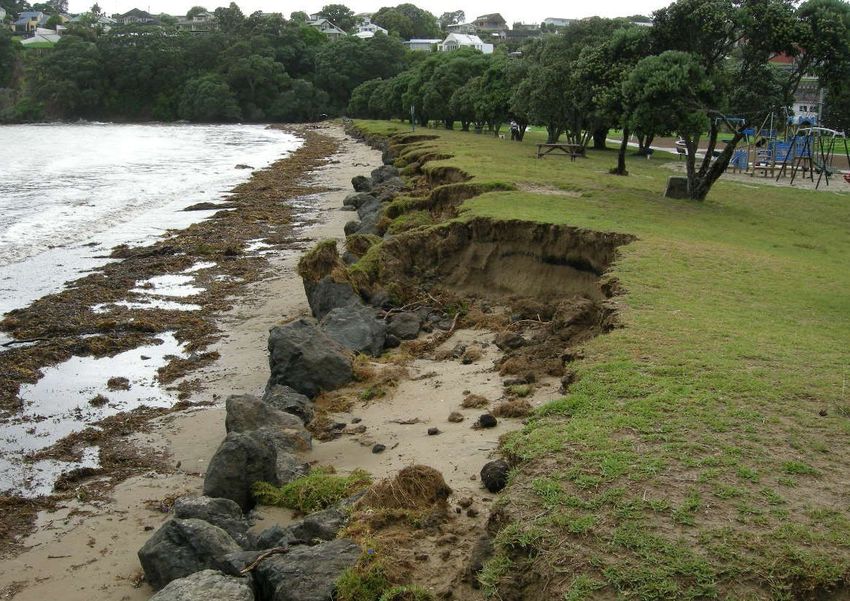
Shoreline Adaptation Plan: Whangaparāoa Pilot
January 2022
Auckland Council

ISBN 978-1-99-110118-1 (Print)

ISBN 978-1-99-110119-8 (PDF)

Externally reviewed and recommended for publication by:

Name: Richard Reinen-Hamill
Position: Technical Director, Tonkin and Taylor

Internally reviewed and recommended for publication by:

Name: Paul Klinac
Position: General Manager Resilient Land and Coasts

Approved for publication by:

Name: Barry Potter
Position: Director Infrastructure and Environmental Services

Recommended citation:

Howe, T., N. Carpenter, R. Reinen-Hamell, M. McNeill, M. Rivers (2022). Shoreline adaptation plan: Whangaparāoa pilot 2022

©2022 Auckland Council

This publication is provided strictly subject to Auckland Council’s copyright and other intellectual property rights (if any) in the publication.
Users of the publication may only access, reproduce and use the publication, in a secure digital medium or hard copy, for responsible
genuine non-commercial purposes relating to personal or public service, provided that the publication is only ever accurately reproduced
and proper attribution of its source, publication date and authorship is attached to any use or reproduction. This publication must not be
used in any way for any commercial purpose without the prior written consent of Auckland Council. The use of this publication for
professional training purposes, regardless of whether payable or free of charge, also requires Auckland Council’s prior written consent.
Auckland Council does not give any warranty whatsoever, including without limitation, as to the availability, accuracy, completeness,
currency or reliability of the information or data (including third party data) made available via the publication and expressly disclaim (to
the maximum extent permitted in law) all liability for any damage or loss resulting from your use of, or reliance on the publication or the
information and data provided via the publication. The publication, information, and data contained within it are provided on an "as is"
basis.

Front cover
Picture of 2018 erosion event at Stanmore Bay, Whangaparāoa.

Acknowledgements
This document was written in the spirit of partnership with Ngāti Manuhiri, Ngāi Tai ki Tāmaki, and
the I&ES Operational Kaitiaki Forum. It was prepared with technical input from Tonkin + Taylor and
advice from Healthy Waters, Parks Sports and Recreation, Community Facilities, Democracy and
Engagement, Plans and Places, and Auckland Transport and Watercare.
1.0                  Table of Contents
Whakataukī ...................................................................................................................................... i
1.0       Te Ao Māori ..........................................................................................................................1
1.1       Te Ora ō Tāmaki Makaurau wellbeing framework .................................................................1
1.2       Treaty relationships and governance .................................................................................. 2
1.3        Operational guiding principles for Shoreline Adaptation Plans............................................ 2
2.0        Regional context ................................................................................................................. 3
2.1        Introduction ........................................................................................................................ 3
2.2        What are shoreline adaptation plans? ................................................................................. 3
2.3        Whangaparāoa pilot ............................................................................................................ 4
3.0        Whangaparāoa context........................................................................................................ 5
3.1        Historic and cultural context ............................................................................................... 6
3.2        Mātauranga ā-iwi from Ngāti Manuhiri and Ngāi Tai ki Tāmaki ............................................ 6
      3.2.1     Whakapapa (Ancestry) .................................................................................................. 7
      3.2.2         Taiao (Environment) .................................................................................................. 7
      3.2.3         Tangata Hononga (Connecting people)...................................................................... 8
4.0        Coastal processes, hazards, and exposure .......................................................................... 9
4.1        Coastal processes on the peninsula .................................................................................... 9
4.2        Coastal hazards ..................................................................................................................10
4.3       Exposure assessment ......................................................................................................... 12
5.0       Community engagement.....................................................................................................14
      5.1.1     Community objectives ..................................................................................................16
6.0       Adaptation strategies ......................................................................................................... 17
6.1       Values ................................................................................................................................17
6.2       Guidance for Auckland Council asset owners .....................................................................18
6.3       High-level adaptation strategies ........................................................................................18
      6.3.1         Red Beach.................................................................................................................19
      6.3.2         Stanmore Bay .......................................................................................................... 22
      6.3.3         Big Manly ................................................................................................................. 26
      6.3.4         Army Bay ................................................................................................................. 30
      6.3.5         Shakespear Park .......................................................................................................31
      6.3.6         Gulf Harbour ............................................................................................................ 36
      6.3.7         Little Manly ............................................................................................................. 38
      6.3.8         Arkles Bay/Wade Heads ........................................................................................... 40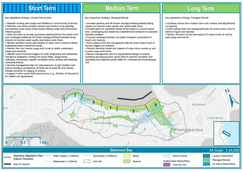
Shoreline adaptation plan: Whangaparāoa pilot 2022
6.3.9 Weiti River ............................................................................................................... 42
6.4 Implementation of the Shoreline Adaptation Plans ........................................................... 43
6.4.1 Māori outcomes ....................................................................................................... 44
7.0 Conclusions ....................................................................................................................... 45
7.1 Next steps ......................................................................................................................... 46
8.0 References ........................................................................................................................ 47
Figures
Figure 3-1: Aerial image of Whangaparāoa Peninsula ......................................................................................... 5
Figure 4-1: A) Steep and horizontally bedded East Coast Bays Formation cliff and wave cut platform,
Stanmore Bay. B) Beach at Manly showing narrow planted dune fronting a grassed low level alluvial deposit
.......................................................................................................................................................................... 10
Figure 4-2: Maps showing extent of A) areas susceptible to coastal instability and erosion, B) coastal
inundation, and C) rainfall flooding. .................................................................................................................. 11
Figure 4-3: Outline of the Whangaparāoa Peninsula showing delineation of the 9-unit areas ........................ 12
Figure 4-4: Results of exposure assessment .................................................................................................... 13
Figure 5-1: Social Pinpoint maps generated from the digital engagement. ...................................................... 15
Figure 6-1: Satellite image of Whangaparāoa Peninsula ................................................................................... 19
Figure 6-2: Adaptation strategies for coastal stretches within Red Beach unit area ....................................... 19
Figure 6-3: Photographs of coastal stretch 3 ................................................................................................... 21
Figure 6-4: Adaptation strategies for coastal stretches within Stanmore Bay unit area ................................. 22
Figure 6-5: Beach access ramp at Cooper Lea Reserve .................................................................................... 23
Figure 6-6: Stanmore Bay Park, photograph facing east .................................................................................. 24
Figure 6-7: Detailed values analysis for Stanmore Bay Park ............................................................................ 25
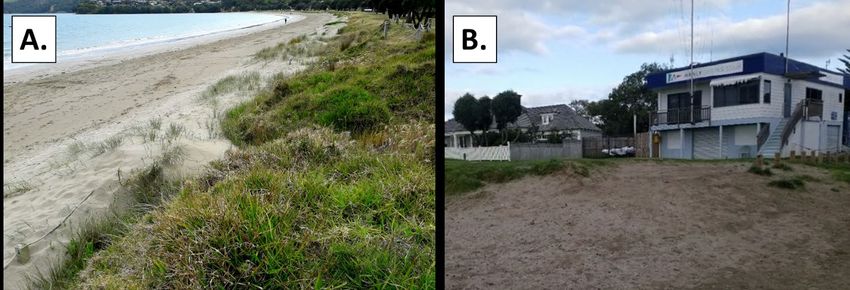
Figure 6-8: Adaptation strategies for coastal stretches within Big Manly unit area ........................................ 26
Figure 6-9: A) Big Manly Beach (facing east) and B) Manly Sailing Club .......................................................... 27
Figure 6-10: Detailed values analysis for Big Manly ......................................................................................... 28
Figure 6-11: Tindalls Beach ............................................................................................................................... 29
Figure 6-12: Adaptation strategies for coastal stretches within Army Bay unit area .......................................30
Figure 6-13: Relic promontory at Fisherman’s Rock Reserve ........................................................................... 31
Figure 6-14: Adaptation strategies for coastal stretches within Shakespear Park unit area ........................... 31
Figure 6-15: Army Beach ................................................................................................................................... 32
Figure 6-16: Te Haruhi Bay ................................................................................................................................ 34
Figure 6-17: Detailed values analysis for Shakespear Regional Park ................................................................ 35
Figure 6-18: Adaptation strategies for coastal stretches within Gulf Harbour unit area ................................. 36
Figure 6-19: Adaptation strategies for coastal stretches within Little Manly unit area ................................... 38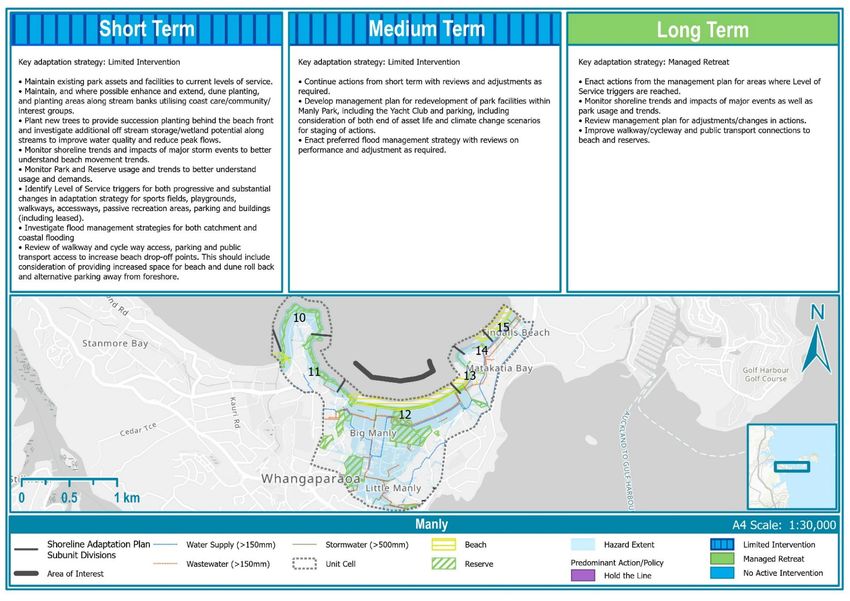
Figure 6-20: Little Manly beach facing east, towards coastal stairway ........................................................... 39
Figure 6-21: Adaptation strategies for coastal stretches within Wade Heads unit area ................................. 40
Figure 6-22: Arkles Bay Beach .......................................................................................................................... 41
Figure 6-23: Adaptation strategies for coastal stretches within Weiti River unit area .................................... 42
Figure 7-1: Adaptation strategies across all 35 coastal stretches ....................................................................45
i

                                         Whakataukī

Mana whenua have gifted the following whakataukī (proverb) as a guide and ultimate objective for
                                this shoreline adaptation plan:

          Toitū te marae a Tāne-Mahuta, Toitū te marae a Tangaroa, Toitū te tangata

                   If the land is well and the sea is well, the people will thrive.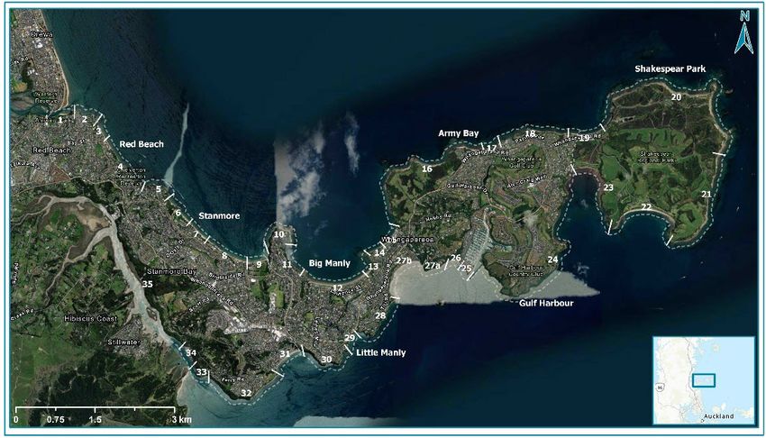
1

1.0             Te Ao Māori
The Māori worldview (te ao Māori) acknowledges the interrelationship of all living and non-living
things and speaks to the vital connection between human beings and the natural environment in
which they live. Within te ao Māori, all things - people, birds, fish, trees, oceans, weather patterns -
are members of an interconnected, cosmic family which stretches back into the past and far into the
future. The waiora (wellbeing) of humans is interlinked with the ecosystems that support them.
Understanding this interconnectedness is a fundamental part of addressing climate change and its
impacts.

As an adaptation workstream within Te Tāruke-ā-Tāwhiri: Auckland’s Climate Plan, Shoreline
Adaptation Plans (SAPs) respect te ao Māori by giving effect to the Kia Ora Tāmaki Makaurau and Te
Ora ō Tāmaki Makaurau frameworks.

1.1      Te Ora ō Tāmaki Makaurau wellbeing framework
Te Ora ō Tāmaki Makaurau is the wellbeing framework developed by the Mana Whenua Kaitiaki
Forum in response to Te Tāruke-ā-Tāwhiri. It is a regional innovation that is built on generations of
knowledge and reflects the world view of the various mana whenua, iwi, rangatahi Māori and Māori
communities of Tāmaki Makaurau. Te Ora aligns with Kia Ora Tāmaki Makaurau and supports Te
Tātai. The Te Ora framework incorporates kaupapa Māori and mātauraunga-ā-iwi and is underpinned
by the principles of te Tiriti o Waitangi, particularly the principles of partnership and active
protection. Within Te Ora, there are three dimensions of wellbeing that form a holistic approach:
Taiao (environment), Whenua (land, earth), Tangata (people).

Figure 1-Graphic of Te Ora ō Tāmaki Makaurau Wellbeing Framework
Shoreline adaptation plan: Whangaparāoa pilot 2022                                                     2

When considered together, these dimensions can frame our adaptation to climate change by taking a
whole living systems approach. Our response to climate change is also guided by the following values
and principles:
       •    Manaakitanga
       •    Kaitiakitanga
       •    Whangauangatanga
       •    Rangatiratanga
       •    Mātauranga
       •    Oritetanga
       •    Tōnuitanga.

1.2        Treaty relationships and governance
The hapū and iwi of Tāmaki Makaurau, known as mana whenua, hold important values as kaitiaki
(guardians or protectors). These include their environmental and spiritual ties to ancestral lands,
water, sites, wāhi tapu (sacred areas) and other taonga (treasures), and the wellbeing of the entire
iwi.

Auckland Council, as set out in The Auckland Plan 2050, looks to recognise and provide for te Tiriti o
Waitangi outcomes. Treaty principles provide guidance for decision-making, partnership, and
collaboration between mana whenua and government. This can include co-governance and co-
management approaches, including for natural resources where holistic, integrated and sustainable
outcomes are sought.

To date the Crown has provided Treaty settlement redress to a number of mana whenua groups that
relate to the Whangaparāoa Peninsula and its adjacent sea-ways. The Hauraki Gulf Forum, a
statutory body under the Hauraki Gulf Marine Park Act 2000, promotes and facilitates integrated
management and the protection and enhancement of the Hauraki Gulf, and has adopted a co-
governance leadership model.

1.3        Operational guiding principles for Shoreline Adaptation
           Plans
In the spirit of partnership, the Auckland Council Infrastructure and Environmental Services Mana
Whenua Kaitiaki Forum developed the following guiding principles for all Shoreline Adaptation Plans:
   •   Responsive to iwi management plans
   •   Accept reversal of infrastructure to rectify hazard issues
   •   Naturalise, let nature take its course
   •   Look at emissions as well (if any)
   •   Whenua concepts are written up and understood by all in plans
   •   Protect koiora (biodiversity) and traditional mahinga kai (fish stocks, kaimoana)
   •   Protect heritage where possible.
These principles align with the Te Ora framework and help guide the Shoreline Adaptation Plans work
programme and its implementation.
3
2.0 Regional context
2.1 Introduction
Auckland is a coastal city, bounded to the east and west by the South Pacific Ocean and the Tasman
Sea. The region has roughly 3,200 km of dynamic coastline and encompasses three major harbours:
the Kaipara, Manukau and Waitemata. Due to its location, much of the city’s urban development and
supporting infrastructure are concentrated in coastal areas and are exposed to coastal processes
such as erosion and inundation. These natural processes are considered hazards when they impact
on things or locations of value. Climate change related to greenhouse gas emissions is contributing to
rising sea levels which have a range of impacts including increasing the frequency and magnitude of
coastal hazard events. Responding to these impacts, in 2020, Auckland Council declared a climate
emergency and published Te Tāruke-ā-Tāwhiri: Auckland’s Climate Plan 1,. To implement the Climate
Plan and support a resilient future for Auckland’s coast, Auckland Council needs to build integrated
coastal management and climate adaptation into its long-term strategic planning processes.
2.2 What are shoreline adaptation plans?
Shoreline adaptation plans (SAPs) are non-statutory, strategic documents that support the
sustainable management of Auckland Council-owned coastal land and assets (including but not
limited to, reserves, coastal defence structures and Auckland Council-owned facilities) over the next
100 years. These plans consider the potential impacts of coastal erosion, coastal inundation, rainfall
flooding, and climate-change impacts (including sea level rise) and seek to provide an adaptive
planning approach that is focused on the needs and values of local iwi and local communities.
Acknowledging the environmental and landscape value of the shoreline, SAPs also work to promote
the preservation, enhancement, and ecological restoration of the coastal environment for future
generations. Recognising the high number of non-Auckland Council assets in shoreline areas, these
plans are developed with input from stakeholder partners such as Auckland Transport, Watercare,
Waka Kotahi, and other infrastructure and utility providers.
The need for SAPs was set out in the Coastal Management Framework 2 (‘the Framework’) adopted by
Auckland Council in 2017 3. The Framework established Auckland Council’s hierarchy for best practice
coastal management, with SAPs directed by the overarching regional philosophy for coastal
management. To support the holistic development of these plans, the Auckland region has been
broken into 16 coastal cells of varying size. The Framework recognised SAPs as non-statutory
documents that will inform comprehensive, long-term planning. Each coastal cell identified within
the Framework will have its own SAP informed by local iwi, infrastructure providers, and local
community engagement. The SAPs will be implemented through integration of all recommended
adaptive strategies into relevant Auckland Council Asset Management Plans. Once all 16 SAPs have
been completed, they will also inform regional prioritisation and funding of future asset management.
1
Auckland Council (2020). Te Tāruke-ā-Tāwhiri: Auckland’s Climate Plan.
2
Carpenter, N., Sinclair, S., Klinac, P., Walker, J (2017) Coastal management framework for the Auckland region.
3
Within the Coastal Management Framework, Shoreline Adaptation Plans were previously referred to as Coastal Compartment
Management Plans.Shoreline adaptation plan: Whangaparāoa pilot 2022 4
The SAPs give effect to the New Zealand Coastal Policy Statement, which directs councils to identify
areas that may be affected by coastal hazards over a timeframe of at least 100 years. Their approach
aligns with guidance from the Ministry for the Environment 4, in particular through the establishment
of mana whenua and community values and objectives and the development of a coastal hazards
vulnerability and risk assessment. It will culminate in the development of Dynamic Adaptive Policy
Pathways, providing a ‘roadmap’ for changing coastal management strategies over time.
At this stage, Auckland’s SAPs are focused on Auckland Council-owned coastal land and assets, as
described within the overarching Shoreline Adaptation Plan Regional Context Report 5. This includes:
• Parks and community facility assets including coastal defences (e.g., seawalls), public
amenity assets (e.g., boat ramps) and coastal access (e.g., walkways)
• Stormwater assets such as stormwater pipes and culverts
• Environmental assets that provide a valuable habitat and buffer from coastal hazards (e.g.,
beaches and mangroves) or natural unique features (e.g., outstanding natural features)
In addition to the above council owned assets and land, the plans consider cultural heritage sites and
places including physical features (e.g., historic buildings, structures and archaeological sites) as well
as intangible values that reinforce a sense of history and identity, are central to wellbeing, and help
define what is unique and distinctive about Auckland.
Overall, the Shoreline Adaptation Plans enable a best practice method for developing the Dynamic
Adaptive Policy Pathways recommended by the Ministry for the Environment, while also recognising
the reforms to the Resource Management Act currently underway. It is anticipated that an iterative
approach to the SAPs will be adopted, aligning with international approaches to coastal management
such as the UK’s Shoreline Management Plans.
2.3 Whangaparāoa pilot
The Whangaparāoa Pilot Report is the first SAP to be developed for the Auckland region. The
Whangaparāoa Peninsula was chosen as it has a variety of different coastal environments, a mix of
Auckland Council-owned land and assets, and strong, established communities. The peninsula has
also had historical issues with coastal hazards, with both north and south Whangaparāoa identified
as ‘coastal hotspots 6’ in the Coastal Management Framework.
4
Ministry for the Environment (2017). Coastal Hazards and Climate Change – Guidance for Local Government.
5
Auckland Council (2021) Shoreline Adaptation Plans: Regional Context
6
Sections of coast identified as experiencing recurrent coastal management issues including erosion, inundation and renewal of
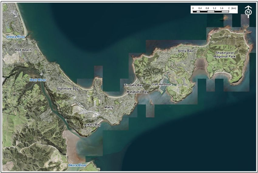
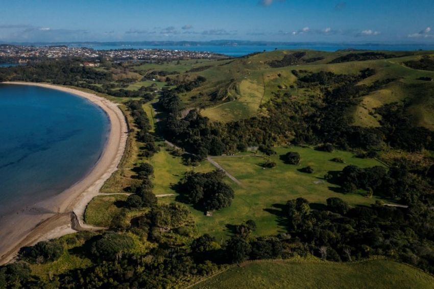
coastal structures.5 3.0 Whangaparāoa context Whangaparāoa Peninsula is located approximately 25 km north of central Auckland and is defined by the Ōrewa Estuary to the north and the Weiti River to the south (Figure 3-1). The peninsula extends east some 11 km into the Hauraki Gulf and has a diverse shoreline, including a mix of sandy beaches (e.g. Stanmore Bay Beach and Te Haruhi Bay), high steep cliffs (e.g. Tarihunga Point), and modified coast (e.g. Gulf Harbour Marina). Figure 3-1: Aerial image of Whangaparāoa Peninsula The proximity of Whangaparāoa to central Auckland makes the peninsula a popular place to both live and visit. Communities on the peninsula include Red Beach, Stanmore Bay, Manly, Tindalls Beach, Army Bay, Gulf Harbour, Matakatia, and Arkles Bay. The eastern tip of Whangaparāoa is home to Shakespear Regional Park which includes several beaches, cliff-top walkways and public amenities. Popular parks along the peninsula are enhanced by their coastal location including Manly Park and Stanmore Bay Park.
Shoreline adaptation plan: Whangaparāoa pilot 2022                                                                                        6

3.1                    Historic and cultural context
Whangaparāoa is translated as the ‘Bay of Sperm Whales’ and has been a site of Māori occupation for
several centuries 7. Part of a series of settlements spanning from Mahurangi in the north to the
Waitemata in the south, the Whangaparāoa peninsula played an important role in the migrations,
conquests and trading networks of a number of Maori groups 8. The seaway immediately north of
Whangaparāoa was a known resting place for migrating whales and their calves 9. The distribution of
archaeological sites confirms that Maori occupation was concentrated along Whangaparāoa’s
southern coast, centred on Te Haruhi, the eastern-most bay on the peninsula. The mouth of the Weiti
River was also of strategic importance for giving water access to inland areas and as the starting
point for a significant overland walkway 10. The area near the river’s mouth was cultivated, producing
a variety of food and protected by several pā.

3.2                    Mātauranga ā-iwi from Ngāti Manuhiri and Ngāi Tai
                       ki Tāmaki
Below are the Mātauranga ā-iwi/Values that Ngāti Manuhiri and Ngāi Tai ki Tāmaki have given to
underpin coastal management on the Whangaparāoa Peninsula:
           •    Tino Rangatiratanga – Self-Determination
           •    Rangatiratanga - Leadership
           •    Toitutanga - Sustainability
           •    Whakahautanga - Restoration
           •    Tiakitanga - Stewardship
           •    Manaakitanga – Support.

These values are categorised into three major themes which reflect the Kia Ora Te Tātai outcome:
Whakapapa - Ancestry, Taiao-Environment, and Tangata Hononga - Connecting People. For each
theme, Ngāti Manuhiri and Ngāi Tai ki Tāmaki have provided objectives on how the Shoreline
Adaptation Plan will give effect to these values in Whangaparāoa.

7
    Ngāti Manuhiri Claims Settlement Act, 2012. Ngāti Manuhiri and the Crown: Deed of Settlement Schedule Documents
       (https://www.govt.nz/assets/Documents/OTS/Ngati-Manuhiri/Ngati-Manuhiri-Deed-of-Settlement-Schedule-Documents-21-May-
       2011.pdf)
8
    Cambell, M., Harris, J., McAlister, A. 2013. Auckland Council North and North West Rural Urban Boundary options: cultural heritage
       overview. Report to Auckland Council. CFG Heritage.
9
    Ngāti Manuhiri Settlement Trust, 2021. Cultural Impact Assessment. 53 Schnapper Rock, Schnapper Rock Private Plan Change. NM-
       CIA-2021_53 Schnapper Rock Private Plan Change.
10
     Bickler, S., Cloud, R., Philips, K., Plowman, M., Farley, G., Dodd, A., Baquie, B. 2008. Site R10/80 Whangaparaoa Peninsula: Final
       Excavation Report. Prepared for Gulf Harbour Corporation Ltd, 2008.
7
3.2.1 Whakapapa (Ancestry)
Wāhi tapu are protected, celebrated, and enhanced through an integrated approach, by natural
means first and foremost and in partnership with mana whenua. The celebration of mana whenua
values includes the acknowledgement, respect and recognition of cultural and spiritual values of
mana whenua. Wāhi Tapu and Taonga must be respected, treasured and valued. This may include
archaeological sites, cultural landscapes and artefacts as well as sites of spiritual and historic
significance to the trust. For example, wāhi tapu may include pā sites, battlefields, burial grounds,
significant historic iwi sites, and waka landings.
3.2.1.1 Objectives
• Mana whenua will not prioritise any wāhi tapu and confirm they all require protection and
that all are crucial to mana whenua identity
• Mana whenua should always be contacted/consulted where works will be conducted near
or at wāhi tapu. An open toolbox must be provided to mana whenua proactively/in advance
of any methodology being developed or risks being presented to these sites.
Some examples of valuing Whakapapa include:
• Wāhi Tapu are protected by natural means such as dunes and natives planting
• Respect for significant cultural landscapes and Wāhi Tapu
• Respect for rahui that are established in specific areas
• Continual engagement with mana whenua will support the celebration
• Protecting Marae pā and urupa sites.
3.2.2 Taiao (Environment)
The environment is protected, enhanced and celebrated through an integrated approach, by natural
means first and foremost and in partnership with mana whenua. This includes proactive
enhancement and/or conservation activities that will aim to naturalise and enhance the natural
environment and ultimately contribute towards preserving the coastline. Guardianship and
stewardship of the environment in terms of Kaitiakitanga. Restoration and enhancement of the mauri.
3.2.2.1 Objectives
• Proactively protecting and restoring nature’s first line of defences for the coastline
(prioritising nature’s ability to absorb the effects of climate change)
• Historical planting - mangroves and dunes with native planting all around the coastal area,
consistent with what was historically present. A planting regime should be commenced in
advance of any potential risks
• Pro-actively protect and enhance coastal dunes
• Pro-actively protect and enhance wetlands
• Pro-actively protect and enhance habitats and biodiversity.Shoreline adaptation plan: Whangaparāoa pilot 2022 8
Some examples of valuing Taiao include:
• Restoration planting of native plants along the coastline
• Removal of pest/exotic vegetation. Manual removal is preferred
• Prevention of damage to habitats from sedimentation issues (too much mud or silt
deposition)
• Daylighting of streams with riparian planting.
3.2.3 Tangata Hononga (Connecting people)
Through involving the community, the people are connected and invested in their environment and
therefore uplifted. The shoreline adaptation plan recognises that people and the environment are
holistically intertwined. Resource management should be implemented in a way that sustains and
supports the ability of Manaakitanga, ongoing generosity and hospitality, and enables and supports
mana whenua’s role as Kaitiaki.
3.2.3.1 Objectives
Marine life and whenua cannot be separated. The SAP must be considered and implemented
holistically with an integrated approach as the moana and the whenua cannot be separated.
• Recognising and providing for Kaitiaki opportunities for mana whenua in future
• Make room for water, enable natural processes where possible
• Naturalising where possible (e.g. daylighting of streams).
Some examples of valuing Tangata Hononga include:
• Mana whenua-led planting days with the community
• Educating the community about mana whenua cultural values, Mātauranga Māori and
climate change.9
4.0 Coastal processes, hazards, and
exposure
4.1 Coastal processes on the peninsula
The 11 km extent of Whangaparāoa Peninsula into the Hauraki Gulf varies in width from 800 m to 2.4
km. Most of the coastline is comprised of steep coastal cliffs, interspersed with long sandy beaches
between headlands on the north coast (Stanmore Bay, Manly Beach, Army Bay) and more discrete
embayed beaches on the southern coast (Arkles Bay, Little Manly, Matakatia).
The peninsula is largely sheltered by mainland Auckland, the Coromandel Peninsula and Great
Barrier Island meaning the majority of Whangaparāoa’s wave exposure is from smaller locally
generated wind-waves. Whangaparāoa’s northern and eastern coast is exposed to larger swells from
the north to east angles where there are narrow swell windows between the Coromandel Peninsula
and the Hauraki Islands. In these instances, large, long period swells can build up from low pressure
systems tracking across the Pacific Ocean.
The geology of Whangaparāoa Peninsula is largely formed from the East Coast Bays Formation of the
Waitemata Group (Figure 4-1:A). This is primarily comprised of weak sandstones and mudstones
which have been folded and faulted from periods of previous tectonic activity. Occasionally, this
formation includes volcanic material that locally increases the material strength. The more resistant
sandstones can form steep slopes 20-50 m high which can become unstable, resulting in minor rock
falls or larger episodic cliff failures.
The low-lying areas of the peninsula are comprised of dune and beach deposits from the Karioitahi
Group including Red Beach, Stanmore Bay (Figure 4-1:B), Big Manly Beach and Tindalls Beach, and
areas of swamp deposits from the Tauranga Group including Tindalls Bay, Okoromai Bay and Army
Bay.
The peninsula’s wave exposure and geology (amongst other factors) has influenced the
geomorphology of the coast and the natural features present. For example, the north coast has
generally larger wave-cut shore platforms and sandier embayment beaches because of its greater
exposure to wave energy and erosion processes. Sediment transport processes vary depending on
each site’s orientation, exposure, and sediment supply with overall trends for finer sediments and
larger intertidal environments on the southwestern end of the peninsula.
Various intertidal habitats, wetlands and dunes exist along Whangaparāoa’s coastline, as well as
artificial structures including various sea walls, rock revetments and boat ramps. Sections such as
Gulf Harbour have been modified through reclamation, dredging and construction of large rock
breakwaters. Artificial structures can change coastal processes by reducing sediment supply from
erosion and restricting sediment transport.Shoreline adaptation plan: Whangaparāoa pilot 2022 10
Figure 4-1: A) Steep and horizontally bedded East Coast Bays Formation cliff and wave cut platform, Stanmore Bay. B)
Beach at Manly showing narrow planted dune fronting a grassed low level alluvial deposit (Source: Auckland Council)
4.2 Coastal hazards
Natural processes, such as coastal inundation and erosion, become hazards when they have the
potential to negatively impact things of value. For shoreline areas with assets and infrastructure or
cultural heritage sites near the coastal edge (including recreational and environmental areas),
impacts of coastal hazards can be significant. Hazard mapping is therefore a key component of long-
term, sustainable management of shoreline areas. For information on the hazard maps used, see the
full Whangaparāoa exposure assessment in Appendix A 11.
The entire length of Whangaparāoa’s coastline is susceptible to coastal instability and erosion to
some degree (dependent on geology) (Figure 4-2A). Northern beach areas such as Red Beach, Big
Manly, Stanmore Bay and Army Bay are particularly exposed and susceptible to periodic erosion from
coastal storm events. This can result in lowering of upper beach levels and erosion of adjacent
coastal land or structures, such as experienced during the January 2018 storms.
With its varying topography, exposure from coastal inundation and rain flooding varies across the
peninsula. However, flat, low-lying areas such as Stanmore, Big Manly, Matakatia, and Arkles are at
significant risk of coastal flooding (Figure 4-2B), with increasing pressure over time with sea-level
rise. These areas are also exposed to rainfall flooding impacts as the catchments across the
peninsula drain towards the coast (Figure 4-2C).
11
Tonkin and Taylor (2021). Shoreline adaptation plan – Whangaparāoa Pilot, Exposure Assessment. 1008052.100.WP.VA.v311
A.
B.
C.
Figure 4-2: Maps showing extent of A) areas susceptible to coastal instability and erosion, B) coastal inundation, and C)
rainfall flooding. AEP stands for annual exceedance probability and is the probability that a certain size flood event
might occur in a single year. A 1% AEP flood is often referred to as 1-in-100-year event. SLR stands for sea level rise.Shoreline adaptation plan: Whangaparāoa pilot 2022 12
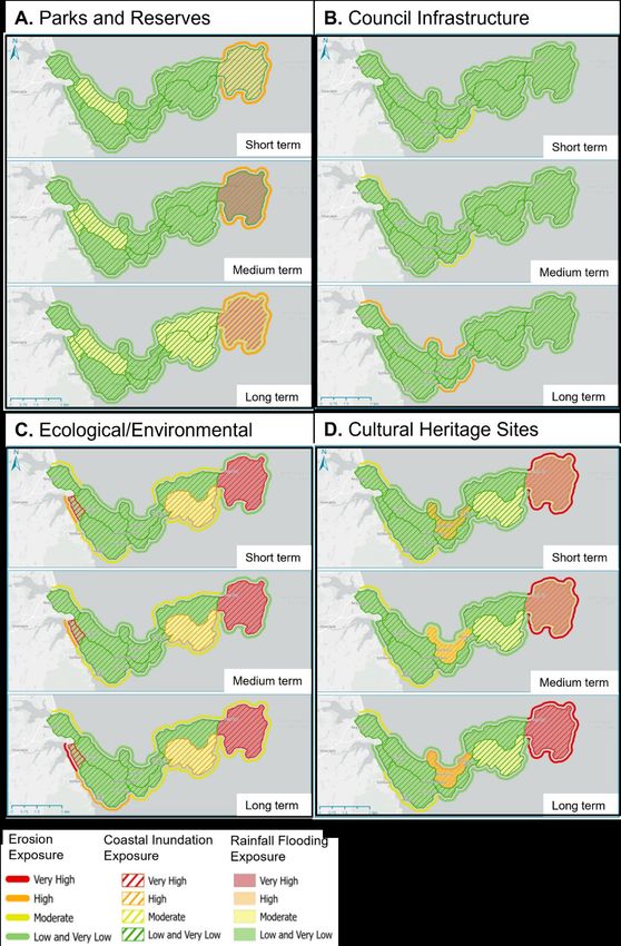
4.3 Exposure assessment
To identify the potential impact of coastal hazards on Auckland Council-owned land and assets and
to understand the escalating risk due to climate change, an exposure assessment 12 was undertaken.
Exposure indicates what elements of interest are located within hazard zones and may subsequently
be adversely affected by hazard events. For Whangaparāoa, elements of interest included parks and
reserve land, Auckland Council-owned infrastructure, ecological and environmental areas, and
cultural heritage sites. Their exposure was assessed using the wellbeing lens of social, environmental,
cultural, and economic indicators, as detailed in the Exposure Assessment Technical Report. To
understand the varying impacts across Whangaparāoa, the peninsula was broken into 9 separate
units as shown in Figure 4-3.
Figure 4-3: Outline of the Whangaparāoa Peninsula showing delineation of the 9-unit areas
The results of the exposure assessment (Appendix A) indicates that Auckland Council-owned land
and assets, including cultural heritage sites, across the Whangaparāoa Peninsula will generally have
low exposure to coastal hazards in the next 20 years (i.e. the short term). However, due to the
impacts of climate change (including sea-level rise and increased rainfall intensity), hazard extents
will increase, increasing exposure in the medium and long term. The largest long-term impact on
infrastructure is related to potential erosion and therefore permanent loss of coastal land. Short
term, intermittent flooding events from both coastal inundation and rainfall flooding can impact
cultural heritage sites including pa sites, middens, and historic buildings. Such events are expected
to increase in size and frequency due to climate change. Flooding may also cause significant damage
to parks, reserves, and ecological areas. Shakespear Regional Park has high exposure in all time
periods due to the extent of its coastal areas and the quantity of cultural heritage sites located within
it. Figure 4.4 shows how exposure for each unit cell changes across the short, medium and long term
in relation to coastal hazards.
12
Tonkin and Taylor (2021). Shoreline adaptation plan – Whangaparāoa Pilot, Exposure Assessment. 1008052.100.WP.VA.v313 Figure 4-4: Results of exposure assessment indicating exposure of A) Parks and reserves, B) public infrastructure (including coastal assets, roads, and three waters pipes), C) Ecological and Environmental areas and D) Cultural Heritage sites for the three natural hazards across the short, medium, and long term. Levels of exposure are shown for each of the three hazards. Coloured lines around the perimeter of the peninsula refer to coastal erosion exposure. Hatching across the unit cells refers to coastal inundation exposure. Shading within the unit cells refer to rainfall flooding exposure. Exposure is ranked from Low to Very High using traffic light colours as shown.
Shoreline adaptation plan: Whangaparāoa pilot 2022                                                 14

5.0           Community engagement
Community engagement for the Whangaparāoa pilot included a range of public outreach events, plus
the establishment of a more focussed Community Reference Group. General events included three
public presentations, which were also live-streamed and recorded, to introduce the SAP process and
key concepts of climate change, coastal hazards, and adaptation planning. These were supported by
two workshops with the Community Reference Group and two open days at the Whangaparāoa
library, at the beginning and end of the community engagement period.

Parallel to the in-person engagement, digital engagement was undertaken using Social Pinpoint, an
online engagement platform that allows users to drop pins, write comments, and complete surveys
on an interactive map. More than 500 unique users participated in the digital engagement. The
information helped identify key community values across the peninsula and highlighted ‘areas of
interest’ as summarised in Figure 5-1.

Comments and surveys collected as part of the digital engagement were sorted and grouped into
four major categories:
     •   Active recreation - how people utilise the coastal areas and provided amenities
     •   Passive recreation - how people connect to and enjoy the coast and reserve areas
     •   Environmental – concerns related to the care and protection of the natural environment
     •   Community – the importance of the coast to community connections.

Comments related to topics outside the scope of SAPs, including transport and management issues,
were forwarded to the relevant departments.

The Community Reference Group was established to enable more focussed discussion of SAP
objectives, values and appropriate adaptation options for Whangaparāoa. It included ten community
members between 25 and 70 years of age from a variety of backgrounds, supported by two members
of the Hibiscus and Bays Local Board.

Two workshops and two group calls were facilitated with the group. During these events the group
helped to:
     •   Assess and confirm the community values collected via the digital engagement
     •   Develop and state community objectives for coastal management
     •   Provide insight into the importance of the three areas of interest (Stanmore Bay, Big Manly,
         and Shakespear Park) to the local community.
15 Figure 5-1: Social Pinpoint maps generated from the digital engagement. Map A displays the location of specific comments, with green circles representing the “I go here because” pins and pink circles representing “I value this because” pins. The green and yellow polygons indicate survey locations, which were used to gather further information in targeted areas. Map B is a heatmap highlighting the areas most commented on during the digital engagement, which indicates that Stanmore Bay, Big Manly, and Shakespear Regional Park are areas of high interest to the local community.
Shoreline adaptation plan: Whangaparāoa pilot 2022                                                   16

5.1.1            Community objectives
With the help of the Community Reference Group, the information collected via Social Pinpoint was
pulled together into the following high-level objectives that capture the values of the local
community:
        •   Preserve and enhance the natural environment and ecosystems that support biodiversity
        •   Use natural and nature-based solutions to increase the resilience of coastal systems where
            practicable
        •   Provide diverse recreation options within the Whangaparāoa park and open space network
        •   Provide safe access to the Coastal Marine Area for a range of water-based activities on the
            northern and southern side of the peninsula (e.g, swimming, sailing/boating, kiteboarding
            and surfing)
        •   Have accessible places within reserves where people can enjoy the coastal environment in
            its natural setting
        •   Shoreline management options provide added benefits to amenity and coastal access
        •   Auckland Council to identify opportunities to work with community volunteers to assist
            with the naturalisation of the coastline.
17
6.0 Adaptation strategies
Shoreline adaptation strategies need to be targeted and specific, with the chosen strategy and
pathway taking into account the unique character and values of the coastal areas in question. The
development of adaptation strategies requires consideration of escalating risk, the values of mana
whenua, feedback of infrastructure providers, and the objectives of the local community. Giving
effect to mana whenua values in the development and implementation of adaptation strategies is
essential.
Four major adaptation strategies to set long term management approaches are considered which are
outlined below:
• No Active Intervention (NAI) – Under this approach, natural processes are allowed to
continue. This includes no investment in the provision or maintenance of any defences.
This strategy is automatically selected for areas of the coastline that are not owned by
Auckland Council.
• Limited Intervention (LI) – Under this approach, limited works are undertaken to extend the
existing asset life or to ensure assets remain safe, including localised retreat of individual
assets. This approach acknowledges that the coastline’s position will not be fixed into the
future and may include small-scale nature-based measures (like dune planting) to support
the coastline’s resilience.
• Hold the Line (HTL) – Under this approach, the coastal edge is fixed at a certain location,
using nature-based options (like beach nourishment) or hard structures (like sea walls).
Nature-based options are the preferred method where possible.
• Managed Retreat (MR) – Under this approach, assets and activities are moved away from
hazard-prone areas in a controlled way over time. Managed retreat allows greater space for
natural buffers and reduces asset exposure to natural hazards.
6.1 Values
Adaptation strategies were developed in alignment with the values set by Ngāti Manuhiri and Ngāi
Tai ki Tāmaki (Section 3.2). To align with these values, we recommend that all future shoreline
projects on the Whangaparāoa Peninsula:
• Value Whakapapa (Ancestry) by acknowledging and supporting the cultural and spiritual
values of mana whenua and giving effect to the views of mana whenua regarding culturally
significant sites or areas in any coastal management or engineering options.
• Value Taiao (Environment) by prioritising naturalisation of the shoreline and working to
enhance and protect the natural environment. This includes restoration of the natural
environment in areas where managed realignment has been recommended and considering
nature-based options in areas of hold the line.
• Value Tangata Hononga (Connecting People) by recognising and supporting the
interdependence of people and their environment, providing mana whenua with kaitiaki
opportunities, and working with the local community on volunteering opportunities.Shoreline adaptation plan: Whangaparāoa pilot 2022 18
6.2 Guidance for Auckland Council asset owners
The adaptation strategies developed in the SAP are designed to be integrated across relevant
Auckland Council Plans. In support, guidance to council staff includes:
• All projects must take locations of culturally significant sites into account and give effect to
the views of mana whenua where works will be conducted near or at wāhi tapu.
• Building new assets in the areas susceptible to coastal erosion and instability is not
recommended unless required to meet statutory obligations. Where an asset has a
functional need to be within the hazard zone (such as a boat ramp or beach access), it
should take the dynamic nature of the coastal environment into account and mitigate
through resilient design.
• Renewal of existing assets within the area susceptible to coastal erosion and instability
should also consider the increasing risk, through selection of an appropriate location and
resilient design.
• Building new assets in the areas at risk of the present-day coastal inundation or rainfall
flooding at 1% annual exceedance probability or higher is not recommended. Avoidance of
risk is a priority where practical. Where an asset has a requirement to be located within the
hazard zone, it must be designed to take the long-term risk into account, including the
potential impact of sea level rise over the asset life span as identified through the Ministry
for the Environments Coastal Hazards and Climate Change sea-level rise thresholds (2017).
• A strategic network assessment of coastal access points across the peninsula should be
undertaken prior to renewal of coastal stairways and beach access paths. This will ensure
continued equitable access around the peninsula, while appropriately managing structural
risk.
• To support natural drainage and not increase the risk of rainfall flooding, all projects in the
shoreline area must consider the location of overland flow paths and ensure that future
works do not block these paths.
6.3 High-level adaptation strategies
For Whangaparāoa, the coastline was broken down into 35 ‘coastal stretches’ (Figure 6-1), selected
based on coastal processes, public land boundaries, and infrastructure considerations. The following
section provides detail on the high-level strategies developed for each coastal stretch over the short
(0-20 years), medium (20-60 years), and long (60 years and onwards) term, with an indication of how
these choices reflect the escalating risk, considerations of infrastructure providers, and the values
and objectives of mana whenua and the local community. Coastal stretches are grouped into the
related unit areas (see Figure 4-3) for clarity.19 Figure 6-1: Satellite image of Whangaparāoa Peninsula. Numbering refers to the breakdown of coastal stretches within the SAP. 6.3.1 Red Beach The Red Beach unit area contains Coastal Stretches 1 through 4. There are 14 identified cultural heritage sites in this shoreline area. Figure 6-2: Adaptation strategies for coastal stretches within Red Beach unit area. Abbreviations: NAI (no active intervention, LI (limited intervention), HTL (hold the line), HTL-MS (hold the line, maintain structure), HTL* (hold the line, private), MR (managed realignment).
Shoreline adaptation plan: Whangaparāoa pilot 2022                                                       20

  Coastal           Short-term                Medium-term                    Long-term
  stretch

      1               LI/HTL*                      MR                           MR

     2                  NAI                        NAI                          NAI

     3                HTL-MS                     HTL-MS                         MR

     4                   LI                         LI                           LI

6.3.1.1        Coastal Stretch 1: Amorino Park

Coastal Stretch 1 is located on the southern side of the mouth of the Orewa estuary, between the
Hibiscus Coast Highway and the river outlet, including all of Amorino Park.

In the short term, the estuarine edge of the park is exposed to flooding from coastal inundation at the
20% annual exceedance probability (1-in-5-year event) and rainfall at the 1% annual exceedance
probability (1-in-100-year events). However, the park is relatively sheltered from severe storm waves
and experiences limited erosion. To support Taiao, limited interventions will be undertaken to
enhance the natural environment.

At the end of its asset life (expected in the medium term), we recommend the footpath at the
western end of the park be realigned due to erosion and inundation risk. This managed realignment
will provide space to naturalise the estuarine edge, aligning with mana whenua values that Taiao be
preserved for future generations. In the short term, Pohutukawa will need to be planted in the
southern part of the park to accommodate the eventual loss of trees near the estuarine edge. This
contributes to Tangata Hononga as reserve land with large trees was identified as an important
community value and connection point within the digital engagement.

The esplanade reserve at the eastern end of Amorino Park is within the area susceptible to coastal
erosion and instability in the short term. However, this part of the coast is currently protected by a
privately owned seawall with an active consent until 2052. At the end of that consent, discussions
with property owners will determine the future approach.

6.3.1.2        Coastal Stretch 2: Cliff edge between Amorino Park and Red Beach
               Waterfront Reserve

This stretch of the coast is not owned or managed by Auckland Council. An adaptive strategy of no
active intervention by Auckland Council has therefore been selected.
21 6.3.1.3 Coastal Stretch 3: Northern end of Red Beach This coastal stretch covers the northern part of Red Beach from the Red Beach Waterfront Reserve down to Bay Street. Much of this coastal stretch is defended by a revetment that was reconstructed in 2016 and has an expected life of 25 years with periodic maintenance as required. The revetment provides protection from erosion and supports the clubhouse of the Red Beach Surf Life Saving Club, while boat ramps provide recreational water access (Figure 6-3). Sailing and boating and kite surfing activities were highlighted in both the digital and in-person engagements as key values of the local community. Surf clubs were noted as particularly important as they are hubs of community activities. The reserve area is high enough that it is unlikely to experience flooding issues in the short and medium term. However, in the longer term, the area will be exposed to increasing flooding from coastal inundation due to sea level rise during significant storm events. At the consent renewal stage, we recommend the surf club be relocated landward and raised to mitigate the flood risk. Figure 6-3: Photographs of coastal stretch 3 showing A) Red Beach Surf Club and B) supporting revetment (facing south) 6.3.1.4 Coastal Stretch 4: Red Beach South of Bay Street This stretch of coast covers Red Beach south of Bay Street and includes Marellen Drive Beach Reserve, Glenelg Reserve, and the connecting esplanade reserve. Community feedback in this area focused on the importance of recreational water access. It is recommended that assets currently providing access in this area be maintained and renewed as required. This area is identified for ongoing limited intervention, with the intent to support Taiao through naturalisation. The rock revetment at Marellen Drive Beach Reserve should be retained in the short term, with the understanding that this will likely require managed realignment in the medium term.
Shoreline adaptation plan: Whangaparāoa pilot 2022                                                                     22

6.3.2             Stanmore Bay
The Stanmore Bay unit area contains Coastal Stretches 5 through 9. There are seven identified
cultural heritage sites in this shoreline area. Stretch 9 was highlighted as an area of particular
interest by the local community and the implications of the adaptive strategies at that location are
discussed in more detail.

Figure 6-4: Adaptation strategies for coastal stretches within Stanmore Bay unit area. Abbreviations: NAI (no active
intervention, LI (limited intervention), HTL (hold the line), HTL-MS (hold the line, maintain structure), HTL* (hold the
line, private), MR (managed realignment)

 Coastal                  Short-term                     Medium-term                           Long-term
 stretch

       5                      NAI                              NAI                                 NAI

       6                      NAI                              NAI                                 NAI

       7                       LI                               LI                                  LI

       8                      NAI                               LI                                  LI

       9                       LI                              MR                                  MR

6.3.2.1           Coastal Stretch 5: Duncansby Lookout and Esplanade Reserve

Coastal Stretch 5 is characterised by vegetated cliffs, with a small pocket beach at the eastern end of
the stretch. An adaptive strategy of no active intervention was selected across all timeframes for this
area. This strategy acknowledges natural processes and aligns with mana whenua objectives to value
Taiao.

While the digital engagement did not capture any values related to this part of the coastline or the
Duncansby lookout, coastal access is a key community objective, and assets that provide coastal
access in this area should be renewed. When renewal is being undertaken, the exposure of the asset
to coastal hazards needs to be assessed to ensure future sustainability and resilience. Asset
locations will need to be re-assessed at the time of renewal to evaluate the extent of erosion and the
potential landslide risk.
23
6.3.2.2 Coastal Stretch 6: North-west Stanmore Bay
This stretch of the coast covers the north-west part of Stanmore Bay to Cooper Lea Reserve. There
are no identified Auckland Council-owned assets in this area and an adaption strategy of no active
intervention has been selected across all timeframes. This strategy acknowledges natural processes
and aligns with mana whenua objectives to value Taiao.
6.3.2.3 Coastal Stretch 7: Cooper Lea Reserve and Stanmore Bay West Beach
Reserve
The community highlighted this stretch of Stanmore Bay for its walking amenity. The area requires
ongoing management to support continued recreational water access via the beach access ramp at
Cooper Lea Reserve.
Figure 6-5: Beach access ramp at Cooper Lea Reserve
A series of informal, legacy rock walls located around coastal Pohutukawa trees are also present.
Limited intervention was selected as the strategy for this stretch across all timeframes, with no
ongoing maintenance of the informal rock walls. In alignment with valuing Taiao, planting is
recommended to provide a natural buffer against future coastal pressures and enhance the natural
environment. Respecting Tangata Hononga, it is recommended that where there is space to do so,
new planting of Pohutukawa landward be undertaken to ensure that trees are available for future
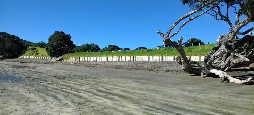
generations.Shoreline adaptation plan: Whangaparāoa pilot 2022 24 6.3.2.4 Coastal Stretch 8: Stanmore Bay East Reserve This stretch includes the coastal accessway at Langton Road and an associated carpark and toilet facilities. Given the proximity of the Langton Road boat ramp to the Stanmore Bay Park Boat Club, we recommend this stretch of coast be naturalised via reshaping and planting. However, pedestrian access should be maintained. An adaptive strategy of no active intervention has been selected in the short term. In the medium and long term, limited intervention has been selected to support naturalisation and the preservation of Taiao. 6.3.2.5 Coastal Stretch 9: Stanmore Bay Park Stanmore Bay Park was identified by the community as an area of high amenity and interest. Due to its low-lying topography, the park is highly exposed to flooding from both coastal and catchment processes. In the short term, an adaptive strategy of limited intervention has been selected. In the medium and long term, however, Auckland Council-owned structures and recreational areas (e.g., lower sports field) will need to be realigned due to the increasing risk of coastal inundation, rainfall flooding and erosion. It is recommended that after Auckland Council-owned structures are relocated, the area be naturalised via reshaping and planting so that Taiao is restored. The walled stormwater channel at the eastern end of the park will need to be reshaped when the wider area is naturalised. Recreational water access at this location may need to be relocated or reconfigured in the long-term (60+ years) due to increasing hazard risk. Management options for the Stanmore Bay Cemetery at the end of the Stanmore Bay Road need to be considered in the next 20 to 30 years. Figure 6-6: Stanmore Bay Park, photograph facing east (November 2020) As Stanmore Bay Park was highlighted as an area of interest in the digital engagement, the adaptive strategies for this area were worked through in detail with the community reference group. The outcome of that discussion is summarised in Figure 6-7.
You can also read