Statistical release (Revised) - Census 2011 P0301.4 - Statistics South Africa
←
→
Page content transcription
If your browser does not render page correctly, please read the page content below
Statistical release (Revised)
                              P0301.4

                          Census 2011

                           Embargoed until:
                           30 October 2012
                                10:00

Enquiries:
Angela Ngyende
Tel. (012) 310 4699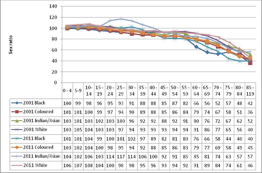
Statistics South Africa                                                                                              P0301.4

Census 2011 Statistical release – P0301.4 / Statistics South Africa

Published by Statistics South Africa, Private Bag X44, Pretoria 0001

© Statistics South Africa, 2012
Users may apply or process this data, provided Statistics South Africa (Stats SA) is acknowledged as the original
source of the data; that it is specified that the application and/or analysis is the result of the user's independent
processing of the data; and that neither the basic data nor any reprocessed version or application thereof may be
sold or offered for sale in any form whatsoever without prior permission from Stats SA.

Stats SA Library Cataloguing-in-Publication (CIP) Data
Census 2011 Statistical release – P0301.4 / Statistics South Africa. Pretoria: Statistics South Africa, 2012

78 pp

A complete set of Stats SA publications is available at Stats SA Library and the following libraries:

           National Library of South Africa, Pretoria Division
           National Library of South Africa, Cape Town Division
           Library of Parliament, Cape Town
           Bloemfontein Public Library
           Natal Society Library, Pietermaritzburg
           Johannesburg Public Library
           Eastern Cape Library Services, King William’s Town
           Central Regional Library, Polokwane
           Central Reference Library, Nelspruit
           Central Reference Collection, Kimberley
           Central Reference Library, Mmabatho

This publication is available on the Stats SA website: www.statssa.gov.za

For technical enquiries please contact:

Calvin Molongoana
Tel:    012 310 4754
Fax:    012 310 4865
Email: calvinm@statssa.gov.za

For dissemination enquiries please contact Printing and Distribution, Statistics South Africa

Ina du Plessis
Email: inadp@statssa.gov.za

                                                                                    Census 2011 Statistical release – P0301.4
Statistics South Africa ii P0301.4
Cautionary notes
Data
‐ Comparison of Census 2011 and previous Censuses requires alignment of data to 2011 municipal
boundaries
Disability
‐ Questions on disability were replaced by General health and functioning questions. Due to change in
question, 2011 results are not comparable with previous Censuses 1996 and 2001.
‐ Due to misreporting on general health and functioning questions for children younger than five years, data
on this variable are only profiled for persons five years and older.
Labour statistics (employment)
‐ Quarterly Labour Force Survey (QLFS) remains the official source of labour statistics
‐ The QLFS_Q4: 2011 has not been benchmarked to Census 2011 figures and the differences between the
two are therefore only broadly indicative
‐ Boundaries - provincial trends over time are difficult to establish due to changes in boundaries
o Census is a de facto measure of the population; while QLFS survey is a de jure measure.
o The reference period in Census (Census night) is fixed while it is a moving reference period over
three months for QLFS
‐ Formal and informal sector:
o An objective measure is used in the QLFS based on vat/income tax registration and establishment
size, a subjective measure is used in Census 2011. Also, in line with ILO guidelines, persons
employed in agriculture and private households are not usually included in the formal and informal
sectors, but are identified as separate categories. It is not currently possible to identify agricultural
employment in Census 2011, since the coding of industry and occupation has not yet been
completed. Sectoral distributions therefore include persons employed in agriculture. And with
regards to persons employed in private households, the results are not based on the relevant
questions that determine the international classification for industry but instead are based on the
question which determines the sector in which respondents were employed. Thus, after coding is
completed the numbers may change.
Rounding off
Due to rounding, the displayed totals in the tables do not always match the sum of the displayed rows or columns.
Census 2011 Statistical release – P0301.4Statistics South Africa iii P0301.4
Contents
Contents...................................................................................................................................... iii
Contents...................................................................................................................................... iii
1. INTRODUCTION ................................................................................................................... 1
1.1 Overview ...................................................................................................................................... 1
1.2 How the count was done .............................................................................................................. 1
1.2.1 Planning ................................................................................................................................ 1
1.2.2 Pre-enumeration ................................................................................................................... 1
1.2.3 Enumeration .......................................................................................................................... 1
1.2.4 Data processing .................................................................................................................... 2
1.2.5 Data editing and validation system ....................................................................................... 2
1.2.5.1 Editing team ................................................................................................................... 2
1.2.5.2 Role of the team ............................................................................................................ 2
1.2.5.3 Editing strategy for Census 2011 ................................................................................... 3
1.2.6 Independent monitoring and evaluation of Census field activities ........................................ 3
1.2.7 Post-enumeration survey (PES) ........................................................................................... 3
1.2.7.1 Preparations for the PES .................................................................................................... 4
1.2.7.2 Methodology .................................................................................................................. 4
1.2.7.3 Sampling ........................................................................................................................ 4
1.2.7.4 Questionnaire development ........................................................................................... 5
1.2.7.5 Fieldwork methodology .................................................................................................. 5
1.2.7.6 Matching and reconciliation methodology ...................................................................... 5
1.2.7.7 PES data collection ........................................................................................................ 5
1.2.7.8 Matching and reconciliation ........................................................................................... 6
1.2.7.9 Estimation and tabulation .............................................................................................. 7
1.3 Conclusion ........................................................................................................................................ 8
2. GEOGRAPHY OF SOUTH AFRICA ...................................................................................... 9
2.1 Provincial boundary changes, 2001-2011 .................................................................................... 9
2.2 Local municipal boundary changes, 2001–2011 ........................................................................ 11
2.3 Comparing Census 2011 with previous Censuses..................................................................... 13
3. FINDINGS ........................................................................................................................... 14
3.1 Demographic characteristics ...................................................................................................... 14
3.1.1 Introduction ......................................................................................................................... 14
Census 2011 Statistical release – P0301.4Statistics South Africa iv P0301.4
3.1.2 Population size .................................................................................................................... 14
3.1.3 Population composition ....................................................................................................... 18
3.1.4 Sex ratio .............................................................................................................................. 19
3.1.5 Median age ......................................................................................................................... 21
3.1.6 Population structure ............................................................................................................ 22
3.1.7 Concluding remarks ............................................................................................................ 24
3.2 Migration .................................................................................................................................... 25
3.2.1 Introduction ......................................................................................................................... 25
3.2.2 Patterns of migration between Censuses 2001 and 2011 .................................................. 25
3.2.3 Life-time migration patterns ................................................................................................ 27
3.2.4 Citizenship .......................................................................................................................... 29
3.3 Education ................................................................................................................................... 30
3.3.1 Introduction ......................................................................................................................... 30
3.3.2 Attendance at an educational institution ............................................................................. 31
3.3.3 Education attainment ................................................................................................................ 33
3.4 Average annual household income ........................................................................................... 41
3.5 General health and functioning .................................................................................................. 44
3.5.1 Introduction ......................................................................................................................... 44
3.5.2 Type and degree of difficulty ............................................................................................... 46
3.5.3 Assistive devices ................................................................................................................. 46
3.6 Labour market status ................................................................................................................. 48
3.6.1 The labour market in South Africa....................................................................................... 48
3.6.1.1 Introduction ........................................................................................................................ 48
3.6.1.2 National labour market results from Census 2011 and the QLFS_Q4:2011 ....................... 49
3.6.1.3 Provincial labour market rates based on Census 2011 and QLFS_Q4:2011 ..................... 50
3.6.1.4 Key labour market rates by population group, based on Census 2011 .............................. 51
3.6.1.5 Key labour market rates by sex and population group, based on Census 2011 ................. 52
3.6.1.6 Key labour market rates by age group based on Census 2011 .......................................... 54
3.6.2 Conclusion ................................................................................................................................ 55
3.7 Housing ........................................................................................................................................... 56
Census 2011 Statistical release – P0301.4Statistics South Africa v P0301.4
3.7.1 Introduction ......................................................................................................................... 56
3.7.2 Households ......................................................................................................................... 56
3.7.3 Housing ............................................................................................................................... 57
3.7.4 Access to services .............................................................................................................. 59
3.7.5 Household goods ................................................................................................................ 65
3.7.6 Conclusion .......................................................................................................................... 67
3.8 Mortality .......................................................................................................................................... 68
3.8.1 Introduction ............................................................................................................................... 68
3.9 Parental survival ............................................................................................................................. 77
List of maps
Map 2.1: Provincial boundary changes since 2001 .................................................................................................... 10
Map 2.2: Municipal boundary changes since 2001 .................................................................................................... 12
Census 2011 Statistical release – P0301.4Statistics South Africa 1 P0301.4
1. INTRODUCTION
1.1 Overview
Censuses are principal means of collecting basic population and housing statistics required for social and
economic development, policy interventions, their implementation and evaluation. South Africa has conducted
three Censuses (1996, 2001 and 2011). Census 2011 was the third Census to be conducted since the post
democratic elections in 1994 and a number of population and household attributes were measured and variety of
indicators generated. This chapter provides profiles results on all Census topics; demographics, migration,
education, general health and functioning, labour force, mortality, and households.
1.2 How the count was done
Census 2011 was conducted from 9th to 31st October 2011. This section focuses on the various activities that were
carried out prior to the finalisation of the results. They can be summarised as follows: Planning, Pre-enumeration,
Enumeration, Processing and Editing.
1.2.1 Planning
This process involved the development of the overall strategy, the structure for the project, component plans and
budget. These processes were started in 2003 and were subsequently reviewed in 2008, after the completion of
the Community Survey (CS) in 2007. Methodologies and procedures were then developed and tested in a form of
mini tests and pilot in 2008 and 2009 respectively. The findings from these tests helped to refine the plans and
methods for the final test in 2010 called the “Dress Rehearsal”. The latter was expected to be a replica of how the
actual count was to be conducted in 2011, and therefore the timing had to be the same month as the main Census,
i.e. October month.
1.2.2 Pre-enumeration
The pre-enumeration phase mainly involved the final preparatory work before the actual count. It started with mass
production of Census instruments like questionnaires, manuals, field gear etc. The phase also involved acquisition
of satellite offices required in the districts, recruitment of the 1st level of field management staff (District Census
Coordinators - 130 DCCs) and Field work Co-ordinators – 6 000 FWCs. These groups of people were then given
intense training based on their key performance areas. At the same time the country was being sub-divided into
small pockets called enumeration areas (EAs); the underlying principle for this sub-division is that an EA should be
within reach of a Fieldworker and all households in that EA can be covered within the allocated number of days.
This process yielded 103 576 EAs. The other benefit for this sub-division is the finalisation of the distribution plan of
all materials required in the provinces and districts. It also gives a better estimate of the number of field staff to
recruit for the count. The pre-enumeration phase involved over 7 000 staff.
1.2.3 Enumeration
The enumeration phase, started with the training of supervisors as listers. Each person had to list all dwellings
within an EA and had a minimum of 4 EAs to cover. These areas were called supervisory units. As they were
listing, they were also expected to publicise the activities of the Census within their supervisory units. Upon
completion of listing, final adjustments of workload and number of enumerators required were finalised. Training of
enumerators started in earnest, and it mainly covered how to complete the questionnaire and to read a map. The
latter was to aid them to identify the boundaries of their assigned areas. An enumerator was also given a few days
before the start of the count to update their orientation book with any developments that might have happened
since listing, as well as introduce themselves to the communities they were to work with, through posters bearing
their photos and special identification cards. On the night of the 9th October the actual count started with the
homeless and special institutions given special attention. The enumeration phase was undertaken by an army of
field staff in excess of 160 000, inclusive of management.
Census 2011 Statistical release – P0301.4Statistics South Africa 2 P0301.4
1.2.4 Data processing
The processing of over 15 million questionnaires commenced in January 2012, immediately after the completion of
the reverse logistics in December 2011. Each box and its contents were assigned a store location in the processing
centre via a store management system. Each time a box was required for any process it was called through this
system. The processing phase was sub-divided in the following processes: primary preparation - where all
completed questionnaires were grouped into clusters of 25 and the spine of the questionnaire cut off. Secondary
preparation - where questionnaires were finally prepared for scanning, by removing foreign materials in between
pages and ensure that all pages are loose. Scanning - questionnaires were put through a scanner to create an
electronic image. Finally Tilling and completion - where any unrecognized reading/ badly-read image by the
scanner had to be verified by a data capturer. This process took 8 months. Over 2 000 data processors working 3
shifts per day were employed for this phase to ensure that 225 million single pages are accounted for.
1.2.5 Data editing and validation system
The execution of each phase of Census operations introduces some form of errors in Census data. Despite quality
assurance methodologies embedded in all the phases; data collection, data capturing (both manual and
automated), coding, and editing, a number of errors creep in and distort the collected information. To promote
consistency and improve on data quality, editing is a paramount phase in identifying and minimising errors such as
invalid values, inconsistent entries or unknown/missing values. The editing process for Census 2011 was based on
defined rules (specifications).
The editing of Census 2011 data involved a number of sequential processes: selection of members of the editing
team, review of Census 2001 and 2007 Community Survey editing specifications, development of editing
specifications for the Census 2011 pre-tests (2009 pilot and 2010 Dress Rehearsal), development of firewall editing
specifications and finalisation of specifications for the main Census.
1.2.5.1 Editing team
The Census 2011 editing team was drawn from various divisions of the organisation based on skills and
experience in data editing. The team thus composed of subject matter specialists (demographers and
programmers), managers as well as data processors.
Census 2011 editing team was drawn from various divisions of the organization based on skills and experience in
data editing. The team thus composed of subject matter specialists (demographers and programmers), managers
as well as data processors
1.2.5.2 Role of the team
Among other Census activities, editing team roles and responsibilities included:
• Establishment of editing plan/schedule
• Formulation and application of clear and concise editing specifications
• Validation of Census data using other data sources
• Ensuring of consistency of editing rules between Censuses (2001 and 2011) where applicable
• Provision of imputation flags and rates
• Identification of errors and provide corrections where possible
• Review and refinement of the edit specifications based on edit trail evaluations, cross tabulations, and
comparison of Census data with other datasets
• Testing the specifications before confirming and applying them
Editing specification process commenced with activities relating to review of existing editing specifications
guidelines. Census 2001 specifications as well as Community Survey 2007 survey specifications and UN handbook
on Census editing were reviewed to form the basis of the specifications.
Census 2011 Statistical release – P0301.4Statistics South Africa 3 P0301.4
1.2.5.3 Editing strategy for Census 2011
The Census 2011 questionnaire was very complex, characterised by many sections, interlinked questions and
skipping instructions. Editing of such complex, interlinked data items required application of a combination of
editing techniques. Errors relating to structure were resolved using structural query language (SQL) in Oracle
dataset. CSPro software was used to resolve content related errors. The strategy used for Census 2011 data
editing was implementation of automated error detection and correction with minimal changes. Combinations of
logical and dynamic imputation/editing were used. Logical imputations were preferred, and in many cases
substantial effort was undertaken to deduce a consistent value based on the rest of the household’s information. To
profile the extent of changes in the dataset and assess the effects of imputation, a set of imputation flags are
included in the edited dataset. Imputation flags values include the following:
0 no imputation was performed; raw data were preserved
1 Logical editing was performed, raw data were blank
2 logical editing was performed, raw data were not blank
3 hot-deck imputation was performed, raw data were blank
4 hot-deck imputation was performed, raw data were not blank
1.2.6 Independent monitoring and evaluation of Census field activities
Independent monitoring of the Census 2011 field activities was carried out by a team of 31 professionals and 381
Monitoring and Evaluation Monitors from Monitoring and Evaluation division. These included field training, publicity,
listing and enumeration. This was to make sure that the activities were implemented according to the plans and
have independent reports on the same. They also conducted Census 2011 and the Post Enumeration Survey
(PES) Verification studies to identify the out-of-scope cases within Census (a sample of 7 220 EAs) and the PES
sample (600 EAs) as reported in the Census 2011 PES EA Summary Books.
1.2.7 Post-enumeration survey (PES)
A post-enumeration survey (PES) is an independent sample survey that is conducted immediately after the
completion of Census enumeration in order to evaluate the coverage and content errors of the Census. The PES
for Census 2011 was undertaken shortly after the completion of Census enumeration, from November to
December 2011, in approximately 600 enumeration areas (EAs) (which later increased to 608 due to subdivision of
large EAs). The main goal of the PES was to collect high quality data that would be compared with Census data in
order to determine how many people were missed in the Census and how many were counted more than once.
A population Census is a massive exercise, and while every effort is made to collect information on all individuals in
the country, including the implementation of quality assurance measures, it is inevitable that some people will be
missed and some will be counted more than once. A PES assists in identifying the following types of errors:
• Coverage error: this includes both erroneous omissions (e.g. a household that was not enumerated) and
erroneous inclusions (e.g. a household that moved into the enumeration area (EA) after Census but was still
enumerated, or a household that was enumerated more than once).
• Content error: this refers to the errors on the reported characteristics of the people or households
enumerated during Census.
The errors may emanate from the following reasons:
• Failure to account for all inhabited areas in the EA frame;
• EA boundary problems;
Census 2011 Statistical release – P0301.4Statistics South Africa 4 P0301.4
• Incomplete listing of structures and failure to identify all dwellings within an EA;
• Failure to enumerate/visit all listed dwellings within an EA;
• Failure to identify all households within a dwelling unit in instances whereby a dwelling unit has more than
one household;
• Failure to enumerate households (complete questionnaires) for all households due to refusals, unreturned
questionnaires for self-enumeration, inability to contact households, etc);
• Failure to include all individuals within households;
• Failure to observe the inclusion rule based on a person’s presence on Census night (i.e. failure to apply the
de facto rule accurately); and
• Lost questionnaires or damaged questionnaires that could not be processed.
Usually more people are missed during a Census, so the Census count of the population is lower than the true
population. This difference is called net undercount. Rates of net undercount can vary significantly for different
population groups depending on factors such as sex, age and geographic location. Stats SA obtains estimates of
the net undercount, including the type and extent of content errors (reported characteristics of persons and
households enumerated in the Census) using information collected through the PES.
1.2.7.1 Preparations for the PES
Planning involved the development of documents outlining the goal and objectives of the PES, timelines of the
project, identification of resources (financial, human and otherwise) required for implementing the project, and the
development of methodology documents. Timelines for the PES were synchronised with those of Census to ensure
the relevance of the project, and adhered to international best practice for maintaining a closed population between
Census and PES data collection, i.e. it should be carried out within a few months, preferably within six (6) months,
after the completion of Census fieldwork to ensure that the impact of natural population changes, such as births,
deaths and migration, as well as lapses in respondent recall do not complicate the exercise. Activities of the PES
included the following:
• Sampling: sample design and selection;
• Development of data collection methodologies: methods and procedures for data collection (publicity, listing
and enumeration), including quality control measures applied during data collection;
• Development of matching and reconciliation procedures and systems: guidelines for matching, including
rules for determining the match status of households and individuals, as well as computer-based system for
capturing household and person records for matching purposes;
• Questionnaire development: selection of data items which allowed measurement of coverage and content,
including layout design and printing of questionnaire;
• Data collection: publicity, listing and enumeration of households in selected enumeration areas (EAs);
• Matching and reconciliation: office matching (comparison) of Census and PES household and person
records, and revisits to households in order to confirm or get more information that might assist in matching
unresolved cases; and
• Analysis and reporting: compilation of tables and report on PES results.
1.2.7.2 Methodology
The PES is an independent survey that replicates the Census in sampled enumeration areas (EAs). The major
assumption used in the PES is that the Census and the PES are independent, the estimate of the percentage
missed by the PES but found by the Census, and the percentage missed by the Census but found by the PES, can
be used to construct estimates of the percentage missed by both PES and Census. The PES sought to estimate
the total number of persons and households in housing units on the night of 09–10 October 2011 (Census night).
The units of observation were the persons who spent the Census night and/or the PES night in these living
quarters.
1.2.7.3 Sampling
The sampling frame for the PES was the complete list of Census 2011 EAs, amounting to 103 576 EAs. The
primary sampling units (PSUs) were the Census EAs. The principle for selecting the PES sample is that the EA
Census 2011 Statistical release – P0301.4Statistics South Africa 5 P0301.4
boundaries for sampled EAs should have well defined boundaries, and these boundaries should correspond with
those of Census EAs to allow for item-by-item comparison between the Census and PES records. The stratification
and sampling process followed will allow for the provision of estimates at national, provincial, urban (geography
type = urban) and non-urban (geography type = farm and traditional) levels, but estimates will only be reliable at
national and provincial levels. The sample of 600 EAs was selected and allocated to the provinces based on
expected standard errors which were based on those obtained in PES 2001. Populations in institutions (other than
Workers’ Hostels), floating and homeless individuals were excluded from the PES sample.
1.2.7.4 Questionnaire development
The approach to questionnaire design focused on capturing the main elements for measuring coverage and
content errors. Only a few elements from the Census 2011 questionnaire which were not likely to change within a
short period (that is between the Census and the PES reference nights) were retained. The questionnaire allowed
for the classification of each listed person as ‘non-mover’, ‘in-mover’, ‘out-mover’, or ‘out-of-scope’, with regard to
their household presence status on Census night (09–10 October 2011). The data items for the PES questionnaire
included first name and surname, date of birth, age, sex, population group and presence of person in dwelling unit
on Census and/or PES night.
1.2.7.5 Fieldwork methodology
The PES replicated the Census in the sampled EAs, which meant that all methodologies and procedures for data
collection were based on Census methodologies and procedures. PES fieldwork was split into the following three
(3) phases; publicity and listing, enumeration and mop-up operations.
• Publicity and listing were conducted at the same time. Publicity focused on informing and educating
respondents and relevant stakeholders about the purpose of the PES to ensure successful coverage of all
dwelling units (DUs) in selected EAs. Listing involved the recording of all structures (including all DUs,
number of households in DUs and number of persons in households) in the sampled EAs in the EA
Summary Books.
• Enumeration involved interviewing respondents and recording responses in the fields provided in the PES
questionnaire. Self-enumeration for the PES was discouraged, but was used in instances where the
respondent insisted on self-enumeration.
• Mop-up operations were conducted in the form of follow-up visits by senior field staff to households that
could not be contacted during the enumeration period.
1.2.7.6 Matching and reconciliation methodology
The matching exercise involved the comparison of household and person records in Census data and PES data. A
two-way case-by-case matching was conducted using the two sources: PES questionnaires and Census
questionnaires. Reconciliation visits were conducted in order to confirm or get more information that would assist in
matching unresolved cases, i.e. households or individuals enumerated in the Census that did not correspond with
households or individuals enumerated in the PES. Guidelines for matching, including rules for determining the
match status of households and individuals, were developed. A computer-assisted manual matching system was
developed for the capturing of data for matching purposes.
1.2.7.7 PES data collection
PES data collection commenced immediately after the completion of Census fieldwork. The PES is a much smaller
scale operation (and hence easier to control) than the Census. These features enable the PES to deliver a more
accurate estimate of the percentage of people and dwellings missed by the Census. PES data collection (field
operations) was independent from Census operations and the following measures were taken to maintain the
operational independence of the PES:
• independent listing of enumeration areas (EAs) in the PES sample;
• using separate/independent office staff in the PES and Census where possible;
• ensuring the PES interviewers were not employed as Census field staff in the same area, and vice versa;
and
Census 2011 Statistical release – P0301.4Statistics South Africa 6 P0301.4
• maintaining the confidentiality of the PES sample so that Census field and office staff were not aware which
areas are included in the PES.
Temporary personnel (Fieldworkers and Fieldwork Supervisors) were recruited from the EAs/districts in which they
would be working and underwent rigorous training on fieldwork procedures to ensure that they deliver work of high
quality at the end of the fieldwork phase. Experienced permanent staff from Household Surveys (based in
provincial offices) was seconded to the project for the duration of data collection in supervisory positions to ensure
high quality data and minimise costs. The PES followed the integrated approach towards fieldwork; whereby 1
Fieldworker conducted publicity, listing and enumeration in 1 EA. A total of 768 Fieldworkers and Fieldwork
Supervisors were appointed for the collection of data in the 608 EAs (initially 600, but increased to 608 due to split
EAs). A ratio of 1 Fieldwork Supervisor for four (4) Fieldworkers was applied, but due to the spread of the sample in
various districts, this ratio could not always be applied.
1.2.7.8 Matching and reconciliation
The matching process involved the comparison of household and person records in Census data and PES data.
The main phases in the matching process were:
• Initial matching involved searching through the Census records in order to find the corresponding cases from
the PES enumeration records, and vice-versa (a two-way match);
• Capturing involved the capturing of PES and Census information on a capturing tool which formed part of the
computer-assisted manual matching system. Information for non-matched households and persons was also
captured;
• Computer-assisted matching which was the automated assigning of an initial match status for the household
and persons, and persons moving status. This process was done concurrently with the capturing process.
Classifications from initial matching are as follows:
1. Matched
2. possible match
In PES not in Census:
3. in PES not in Census - definite non-match
4. in PES not in Census - insufficient or unclear information
5. in-mover
6. born after Census
7. in Census not in PES;
• Reconciliation visits are follow-up visits to households in the PES sampled EAs. The purpose of
reconciliation visits was to collect relevant information in order to determine the final match status of
unresolved cases identified during initial matching. Cases of ‘possible match’, ‘in PES not in Census -
insufficient or unclear information’, and ‘in Census not in PES’ were considered unresolved and were sent to
the field for reconciliation; and
• Final matching involved the use of the results obtained from the reconciliation visits and initial matching
phases to assign a definite match status to each case. The table below illustrates the outcomes from final
matching.
Census 2011 Statistical release – P0301.4Statistics South Africa 7 P0301.4
1. matched
In PES not in Census:
2. missed in Census
3. PES erroneous inclusion - cases in PES not in Census that were outside
the EA boundaries or otherwise erroneously included in PES
4. PES insufficient information - cases in PES not in Census for which a final
match status cannot be assigned due to insufficient information
5. in-mover
6. born after Census
In Census not in PES:
7. correctly enumerated in Census, missed in PES
8. Census erroneous inclusion
9. Census insufficient information – cases in Census not in PES for which a
final match status cannot be assigned due to insufficient information
1.2.7.9 Estimation and tabulation
Coverage measures were calculated only for cases belonging to the PES universe.
The initial estimates – weighted estimates of total from the sample include the following:
a) Estimated number of non-movers;
b) Estimated number of out-movers;
c) Estimated number of matched non-movers;
d) Estimated number of matched out-movers;
e) Estimated number on in-movers;
f) Estimated number of erroneous inclusions in the Census; and
g) Estimated number of correctly enumerated persons missed in the PES
Dual system estimation was used to arrive at the true population of the country. This means that two independent
sources or ‘systems’ are used to arrive at the estimate of the true population: the Census and the PES. Both
estimates contribute to the dual-system estimate, which is more complete than either the Census or the PES
estimate alone. In the end, this true population is compared with the Census-enumerated population and the
difference is the net undercount (or overcount). The following table indicates the undercount rates as estimated by
the PES.
Census 2011 Statistical release – P0301.4Statistics South Africa 8 P0301.4
Net Census Coverage Error: Total and Rate by Province
Omission rate for Omission rate for
Province persons households
Western Cape 18,6 17,8
Eastern Cape 12,9 10,3
Northern Cape 13,4 14,8
Free State 10,1 9,4
KwaZulu-Natal 16,7 16,5
North West 14,9 17,0
Gauteng 14,7 15,2
Mpumalanga 15,5 14,4
Limpopo 10,0 9,6
All provinces 14,6 14,3
The adjustment procedure consisted of creating homogeneous adjustment classes with similar coverage rates and
calculating a common undercount rate, adjustment factor and adjustment figure for each class separately. The
adjusted figure for the total population was obtained by summing across the adjustment classes. In addition, only
the population of households received adjustment classes. The totals for the balance of the population, namely
people living in collective quarters and the homeless on the streets, were not adjusted.
1.3 Conclusion
The 2011 Census project had its own challenges and successes, like any other massive project. Be that as it may,
the following are worth mentioning; the Census fieldworkers who traverse the country to collect information from
households and those that we lost in the process. The respondents who opened their doors and locked their dogs
to aid the field staff to do their work, the processors who worked 24hrs/7days a week to ensure that the data can be
released within a year of enumeration. The Census management team who met daily for two years to steer the
project forward, the Stats SA EXCO for the leadership they provided, the Statistics Council and in particular the
sub-committee on population and social statistics for their continued guidance and support and finally the Minister
in the Presidency: responsible for planning for the robust interrogation of the plans and guidance on this project. It
is through such concerted efforts that as a country we can and will continuously improve on our endeavours.
Census 2011 Statistical release – P0301.4Statistics South Africa 9 P0301.4
2. GEOGRAPHY OF SOUTH AFRICA
2.1 Provincial boundary changes, 2001-2011
A number of changes occurred in terms of provincial and municipal boundaries during the period between
Censuses 2001 and 2011. Of the nine provinces, only two provinces (Western Cape and Free State) were not
affected by changes. The provincial boundary changes were mostly as a result of eight cross boundary
municipalities which were absorbed in full into respective provinces.
Table 2.1: Geographical land area changes since 2001
Land area in square Land area in square
Province name Provincial code kilometres _2011 kilometres 2001
Western Cape 1 129 462 129 449
Eastern Cape 2 168 966 169 954
Northern Cape 3 372 889 362 599
Free State 4 129 825 129 824
KwaZulu-Natal 5 94 361 92 305
North West 6 104 882 116 231
Gauteng 7 18 178 16 936
Mpumalanga 8 76 495 79 487
Limpopo 9 125 754 122 816
Total 1 220 813 1 219 602
The shift of the national boundary over the Indian Ocean in the North East corner of KwaZulu-Natal to cater for the Isimangaliso Wetland Park
led to the increase in South Africa's land area.
Census 2011 Statistical release – P0301.4Statistics South Africa 10 P0301.4
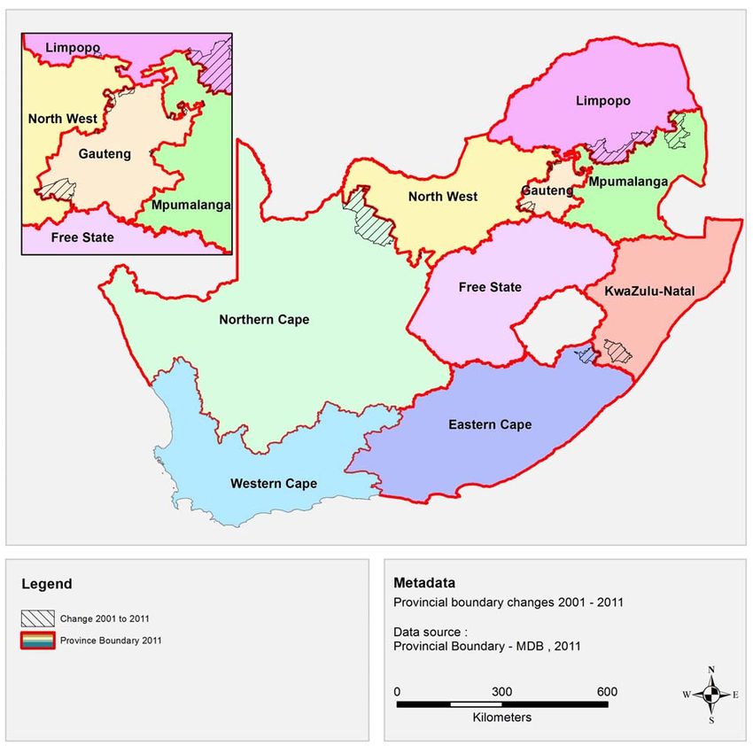
Map 2.1: Provincial boundary changes since 2001
Provincial boundary changes mostly affected North West (land size decreased to 11348,9 square kilometres). Most
of this was absorbed by Northern Cape. The second largest decrease in land size was for Mpumalanga which
decreased by 2991,9 square kilometres with Limpopo being the main recipient of this land area.
It should be noted that the increased extent of KwaZulu-Natal is not mainly based on the exchange of Umzimkulu
(formerly in the Eastern Cape Province) and Matatiele (formerly in KwaZulu-Natal), but due to the shift of the
national boundary over the Indian Ocean in the north east corner of the province to cater for the iSimangaliso
Wetland Park. In terms of which areas moved to which province, a detailed outline is provided for below.
Northern Cape and North West:
• Ga Segonyana and Phokwane municipalities were cross boundary municipalities between Northern Cape
and North West in 2001 and were allocated to Northern Cape in full based on the current provincial
boundaries.
• Kagisano municipality (2001) was split into Kagisano/ Molopo municipality and Joe Morolong municipality,
with the former portion now in North West and the latter now part of the Northern Cape province.
• Moshaweng municipality (now part of Joe Morolong municipality) was incorporated in full in Northern Cape
based on the current provincial boundaries.
Census 2011 Statistical release – P0301.4Statistics South Africa 11 P0301.4
North West and Gauteng
• Merafong City municipality (2001) was a cross boundary local municipality between North West and Gauteng
and was allocated to the Gauteng province based on the current provincial boundaries.
• West Rand (DMA) municipality (2001) was not aligned to the then provincial boundary and was absorbed
into Mogale City municipality in full based on the current provincial boundaries.
• City of Tshwane Metropolitan Municipality was a cross boundary municipality between Gauteng and North
West provinces. The portions adjacent to Moretele and Madibeng municipalities were allocated to Gauteng
in full based on the current provincial boundaries.
North West and Limpopo:
• Limpopo lost a portion of the Bela Bela municipality to North West’s Moretele municipality. In turn North West
lost a portion of the Moretele Municipality to Limpopo’s Bela Bela municipality based on the current provincial
boundaries.
Gauteng and Mpumalanga:
• A portion of Delmas municipality (2001) now called Victor Kanye was allocated to the City of Tshwane in
Gauteng based on the current provincial boundaries.
• Kungwini municipality, now incorporated into the City of Tshwane, was a cross boundary municipality and is
now fully allocated to Gauteng, based on the current provincial boundaries.
Mpumalanga and Limpopo:
• Greater Groblersdal, now Elias Motsoaledi, Greater Marble Hall now Ephraim Mogale, and Greater Thubatse
were cross boundary municipalities between Mpumalanga and Limpopo and have now been allocated in full
to the Limpopo province. Ephraim Mogale municipality was absorbed into the Schuinsdraai Nature Reserve.
• Bushbuck Ridge municipality was a cross boundary municipality between Limpopo and Mpumalanga and
has now been allocated in full to the Mpumalanga province. (Bushbuck Ridge also absorbed a portion of the
Kruger Park cross boundary District Management Area.)
KwaZulu-Natal and Eastern Cape:
Umzimkulu, formerly in Eastern Cape, and Matatiele, formerly in KwaZulu-Natal were in effect exchanged, with
Umzimkulu now being in KwaZulu-Natal and Matatiele now being in Eastern Cape based on the current provincial
boundaries.
2.2 Local municipal boundary changes, 2001–2011
In 2001, the Geographical Frame consisted of 262 local municipalities. This total has been reduced to 234 local
municipalities in the 2011 geographical frame. The difference of 28 municipalities is explained as follows:
In total, 25 District Management Areas (DMAs) were absorbed into the existing provinces.
• The City of Tshwane absorbed a further two municipalities (Nokeng Tsa Taemane and Kungwini).
• A new municipality (Kagisano Molopo – NW379) was established by merging NW391 (Kagisano) and
NW395 (Molopo).
For municipalities, 107 municipalities decreased in geographical area while 155 municipalities had an increase in
geographical area.
Census 2011 Statistical release – P0301.4Statistics South Africa 12 P0301.4
Map 2.2: Municipal boundary changes since 2001
Census 2011 Statistical release – P0301.4Statistics South Africa 13 P0301.4
Figure 2.1: Percentage distribution of land area by province, 2011
2.3 Comparing Census 2011 with previous Censuses
Comparison of Census 2011 with previous Censuses (1996 and 2001) required alignment of data for the two
Censuses to 2011 municipal boundaries. This is because the country’s provincial demarcations underwent a
number of changes at provincial and municipal boundaries as outlined in the section above.
Census 2011 Statistical release – P0301.4Statistics South Africa 14 P0301.4
3. FINDINGS
The 2011 Population and Housing Census was comprehensive, with a number of topics: demographics, migration,
general health and functioning, education, parental survival status, employment, fertility, mortality and statistics on
households. This chapter presents key findings from each of the outlined topics.
3.1 Demographic characteristics
3.1.1 Introduction
A Census is the basic source of demographic information at all levels of geography in a given area at a defined
time. This chapter provides information on size, composition and structure of the population of South Africa from
1996–2007.
3.1.2 Population size
Table 3.1: Total population by province, Censuses 1996, 2001 and 2011
Province Census 1996 Census 2001 Census 2011
Western Cape 3 956 875 4 524 335 5 822 734
Eastern Cape 6 147 244 6 278 651 6 562 053
Northern Cape 1 011 864 991 919 1 145 861
Free State 2 633 504 2 706 775 2 745 590
KwaZulu-Natal 8 572 302 9 584 129 10 267 300
North West 2 727 223 2 984 098 3 509 953
Gauteng 7 834 125 9 388 854 12 272 263
Mpumalanga 3 123 869 3 365 554 4 039 939
Limpopo 4 576 566 4 995 462 5 404 868
South Africa 40 583 573 44 819 778 51 770 560
Censuses 1996 and 2001 have been aligned to 2011 municipal boundaries
Table 3.1 indicates that the population size of South Africa has increased noticeably from 40,6 million in 1996 to
51,8 million in 2011. KwaZulu-Natal, followed by Gauteng, had the majority of the population in both in Censuses
1996 and 2001, but was overtaken by Gauteng in Community Survey 2007 and Census 2011, leaving KwaZulu-
Natal to take second place.
Figure 3.1 shows that there was a noticeable increase in the share of the population in Gauteng from 19,3% in
1996 to 23,7% in 2011 while the share of the population in KwaZulu-Natal remained almost constant (21,1% in
1996 to 19,8% in 2011). Amongst all the provinces, Northern Cape had the lowest share (2,5% in 1996 and 2,2% in
2011) as shown in Figure 3.1. Eastern Cape on the other hand showed a marked decline from 15% 1996 to 12,7%
in 2011.
Census 2011 Statistical release – P0301.4Statistics South Africa 15 P0301.4
Figure 3.1: Percentage distribution of population by province, 1996–2007
Table 3.2: Population and percentage change by province: Censuses 1996, 2001 and 2011, and CS 2007
Census Census 1996-2001 2001-2007 Census 2007-2011
Province 1996 2001 % change CS 2007 % change 2011 % change
WC 3 956 875 4 524 335 14,3 5 278 585 16,7 5 822 734 10,3
EC 6 147 244 6 278 651 2,1 6 527 747 4,0 6 562 053 0,5
NC 1 011 864 991 919 -2,0 1 058 060 6,7 1 145 861 8,3
FS 2 633 504 2 706 775 2,8 27 73 058 2,5 2 745 590 -1,0
KZN 8 572 302 9 584 129 11,8 10 259 229 7,0 10 267 300 0,1
NW 2 727 223 2 984 098 9.4 3 056 083 2,4 3 509 953 14,9
GP 7 834 125 9 388 854 19.8 10 667 505 13,6 12 272 263 15,0
MP 3 123 869 3 365 554 7,7 3 643 507 8,3 4 039 939 10,9
LP 4 576 566 4 995 462 9,2 5 238 285 4,9 5 404 868 3,2
South
Africa 40 583 573 44 819 778 10,4 48 502 059 8,2 51 770 560 6,7
Census 2011 Statistical release – P0301.4Statistics South Africa 16 P0301.4
Table 3.2 provides the provincial percentage share of the total population for the three periods: 1996–2001, 2001–
2007 and 2007 to 2011. The results show a noticeable decrease of -2% in the percentage share of the total
population of Northern Cape from 1996 to 2001. However, both Community Survey 2007 and Census 2011 show
increase in the total population of Northern Cape (6,7% and 8,3% respectively). Gauteng, Western Cape and
KwaZulu-Natal show an increase of the population share of 15%, 10,3% and 0,1% in 2007 to 2011 respectively.
Census 2011 Statistical release – P0301.4Statistics South Africa 17 P0301.4
Table 3.3: Percentage distribution of the population by population group and province, 1996–2011
Black African Coloured Indian/Asian White Other
Province 1996 2001 2007 2011 1996 2001 2007 2011 1996 2001 2007 2011 1996 2001 2007 2011 2011
WC 21,6 26,7 30,1 32,9 56,0 53,9 50,2 48,8 1,1 1,0 1,3 1,0 21,4 18,4 18,4 15,7 1,6
EC 86,6 87,2 87,6 86,3 7,7 7,7 7,5 8,3 0,3 0,3 0,3 0,4 5,4 4,9 4,7 4,7 0,3
NC 44,9 46,5 39,8 50,4 43,7 42,9 50,0 40,3 0,2 0,2 0,2 0,7 11,2 10,3 10,0 7,1 1,6
FS 84,8 88,0 87,1 87,6 3,0 3,1 3,0 3,1 0,1 0,1 0,2 0,4 12,1 8,8 9,6 8,7 0,3
KZN 82,8 85,2 86,0 86,8 1,4 1,5 1,4 1,4 9,3 8,3 8,1 7,4 6,6 5,0 4,4 4,2 0,3
NW 90,1 90,0 91,2 89,8 1,6 1,8 1,7 2,0 0,4 0,3 0,4 0,6 7,9 7,8 6,7 7,3 0,3
GP 72,3 75,2 75,4 77,4 3,6 3,6 3,7 3,5 2,1 2,3 2,6 2,9 22,0 18,8 18,3 15,6 0,7
MP 91,0 93,2 92,0 90,7 0,7 0,7 0,8 0,9 0,4 0,3 0,4 0,7 7,9 5,9 6,8 7,5 0,2
LP 96,9 97,0 97,5 96,7 0,2 0,2 0,2 0,3 0,1 0,2 0,2 0,3 2,8 2,7 2,2 2,6 0,2
SA 77,4 79,0 78,9 79,2 9,0 8,9 9,0 8,9 2,6 2,5 2,6 2,5 11,0 9,6 9,5 8,9 0,5
Table 3.3 indicates that Black African population group has the highest proportion of over 70% in all provinces with the exception of Northern Cape and Western Cape
where the percentages were 32,9% and 50,4%, respectively 2011. On the other hand, coloured population is the highest in the Northern Cape and Western Cape.
However, the figure shows a decreasing pattern in Northern Cape of 43,7% in 1996 to 40,3% in 2011; and 56% to 48,8% in Western Cape. The highest percentage of
Indian or Asian population is found in KwaZulu-Natal. The percentage of this population in the province was 9,3% in 1996 and 7,4% in 2011. Western Cape province and
Gauteng had the highest percentages of the white population group at 21,4% and 22%, respectively, in 1996 which declined to 15,7% and 15,6% respectively in 2011.
Census 2011 Statistical release – P0301.4Statistics South Africa 18 P0301.4
Figure 3.2: Percentage distribution of the population by functional age-groups and sex: Censuses 1996,
2001, 2011, and CS 2007
Figure 3.2 indicates that from 1996 to 2011 the proportion of the population aged 0-14 for both males and females
decreased. The male population in this age group decreased from 35,6% in 1996 to 30,3% in 2011 whilst that of
female population decreased from 33,2% to 28,1%. The proportion of economically active population (15-64)
increased for males from 60,5% in 1996 to 65,6% in 2011. That of females increased from 61,1% in 1996 to 65,4%.
3.1.3 Population composition
Figure 3.3: Percentage distribution of the population by sex, Censuses 1996, 2001 and 2011, and CS 2007
Figure 3.3 presents the percentage distribution of the population by sex in the three Censuses and CS 2007.
Overall; the results indicate that the population is predominantly female. On average, the population consists of
48,2% of the male population and 51,7% of the female population
Census 2011 Statistical release – P0301.4Statistics South Africa 19 P0301.4
3.1.4 Sex ratio
Sex ratio is one of the key measures of sex composition. It gives the number of males for every 100 females. If it is
above 100, it shows the predominance of males over females, conversely when it is lower than 100, the reverse is
true. Generally sex ratios at birth are high and decrease gradually as age increases.
Figure 3.4: Age-specific sex ratios: Censuses 1996, 2001, 2011 and CS 2007
Figure 3.4 indicates that the overall sex ratio increased from 92 in 1996 to 95 in 2011. In general, more males are
born than females hence sex ratios above 100 are expected at younger age groups. The table further indicates an
unexpected pattern of sex ratios of 93 and 91 at ages 25–29 and 30–34 in 2001 that increased markedly to 101
and 102 in 2007 and remained the same for 2011.
Figure 3.5: Overall sex ratios by province
The results in Figure 3.5 show that among all the provinces, GP and NW had the highest sex ratios of over 100 in
2011. NW had a sex ratio of 98 in 1996 that increased to 103 in 2011. Conversely, Limpopo and Eastern Cape had
sex ratios lower than 90 across the years. Evidence from 1996 and 2001 Censuses showed that the two provinces
(Limpopo and Eastern Cape) were the most affected by outmigration in terms of inter-provincial migration.
Census 2011 Statistical release – P0301.4Statistics South Africa 20 P0301.4
Figure 3.6: Age-specific sex ratios for South Africa by population group: Censuses 2001 and 2011
Figure 3.6 indicates an even pattern of age specific sex ratios of population groups in 2001 and 2011 that begins to
decline as age increases. In contrast, age specific sex ratios for the Indian population in 2011 shows considerable
increases from ages 20–24, 25–29 and 30–34 of 114; 117 and 114 respectively.
Figure 3.7: Overall sex ratios by population group, Censuses 1996, 2001, 2011 and CS 2007
Figure 3.7 indicates a stable but increasing pattern of sex ratios ranging from 92 in 1996 to 94 in 2011 for the black
African population group. The coloured population group sex ratios fluctuated between 93 and 94 in all the four
points. However; sex ratios for the Indian population show considerable increase from 96 in 1996 to 101 in 2011.
Census 2011 Statistical release – P0301.4You can also read