SYSTEM STATEMENT 2015 - System Statement Issue Date: Metropolitan Council
←
→
Page content transcription
If your browser does not render page correctly, please read the page content below
2015
SYSTEM
STATEMENT
City of North Oaks
System Statement Issue Date: September 17, 2015
2015 SYSTEM STATEMENT FOR
                              CITY OF NORTH OAKS
                                                System Statement Issue Date: September 17, 2015

Regional Development Plan Adoption
In May 2014, the Metropolitan Council adopted Thrive MSP 2040. Following adoption of Thrive, the
Council adopted the 2040 Transportation Policy Plan, the 2040 Regional Parks Policy Plan, the 2040
Water Resources Policy Plan, and the 2040 Housing Policy Plan. The Metropolitan Council is now
issuing system statements pursuant to State statute.

Receipt of this system statement and the metropolitan system plans triggers a community’s obligation
to review and, as necessary, amend its comprehensive plan within the next three years, by the end of
2018. The complete text of Thrive MSP 2040 as well as complete copies of the recently adopted
metropolitan system and policy plans are available for viewing and downloading
at http://www.metrocouncil.org/Communities/Planning.aspx. Paper copies are available by calling the
Council’s Data Center at 651-602-1140.

System Statement Definition
Metropolitan system plans are long-range comprehensive plans for the regional systems – transit,
highways, and airports; wastewater services; and parks and open space – along with the capital
budgets for metropolitan wastewater services, transportation, and regional recreation open space.
System statements explain the implications of metropolitan system plans for each individual community
in the metropolitan area. They are intended to help communities prepare or update their comprehensive
plan, as required by the Metropolitan Land Planning Act:

        Within nine months after receiving a system statement for an amendment to a metropolitan
        system plan, and within three years after receiving a system statement issued in conjunction
        with the decennial review required under section 473.864, subdivision 2, each affected local
        governmental unit shall review its comprehensive plan to determine if an amendment is
        necessary to ensure continued conformity with metropolitan system plans. If an amendment is
        necessary, the governmental unit shall prepare the amendment and submit it to the council
        for review.

Local comprehensive plans, and amendments thereto, will be reviewed by the Council for conformance
to metropolitan system plans, consistency with Council policies, and compatibility with adjacent and
affected governmental units. Updated local comprehensive plans are due to the Council for review by
December 31, 2018.

What is in this System Statement
The system statement includes information specific to your community, including:

    •   your community designation or designation(s);
    •   forecasted population, households, and employment through the year 2040;
    •   guidance on appropriate densities to ensure that regional services and costly regional
        infrastructure can be provided as efficiently as possible.
    •   affordable housing need allocation;

Page - 1 | 2015 SYSTEM STATEMENT – NORTH OAKS                                              INTRODUCTION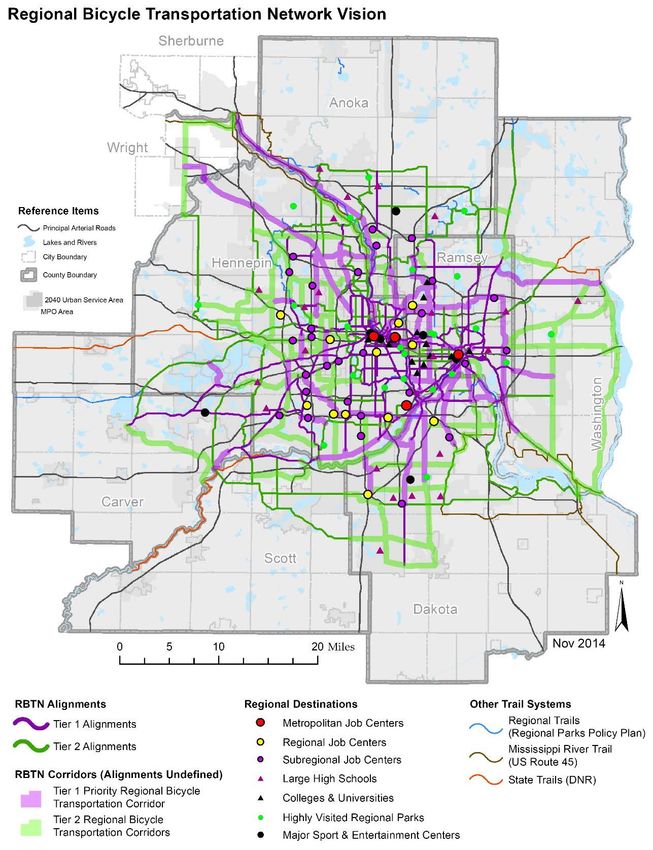
In the following sections, this system statement contains an overview of each of the system plan
updates and specific system changes that affect your community. The sections are:

    •   Transportation, including metropolitan highways, aviation, and transit
    •   Water Resources, including wastewater, surface water, and water supply planning
    •   Regional parks and trails

Dispute Process
If your community disagrees with elements of this system statement, or has any questions about this
system statement, please contact your Sector Representative, Eric Wojchik, at 651-602-1330, to review
and discuss potential issues or concerns.

The Council and local government units and districts have usually resolved issues relating to the
system statement through discussion.

Request for Hearing
If a local governmental unit and the Council are unable to resolve disagreements over the content of a
system statement, the unit or district may, by resolution, request that a hearing be conducted by the
Council’s Land Use Advisory Committee or by the State Office of Administrative Hearings for the
purpose of considering amendments to the system statement. According to Minnesota Statutes section
473.857, the request shall be made by the local governmental unit or school district within 60 days after
receipt of the system statement. If no request for a hearing is received by the Council within 60 days,
the statement becomes final.

Page - 2 | 2015 SYSTEM STATEMENT – NORTH OAKS                                               INTRODUCTION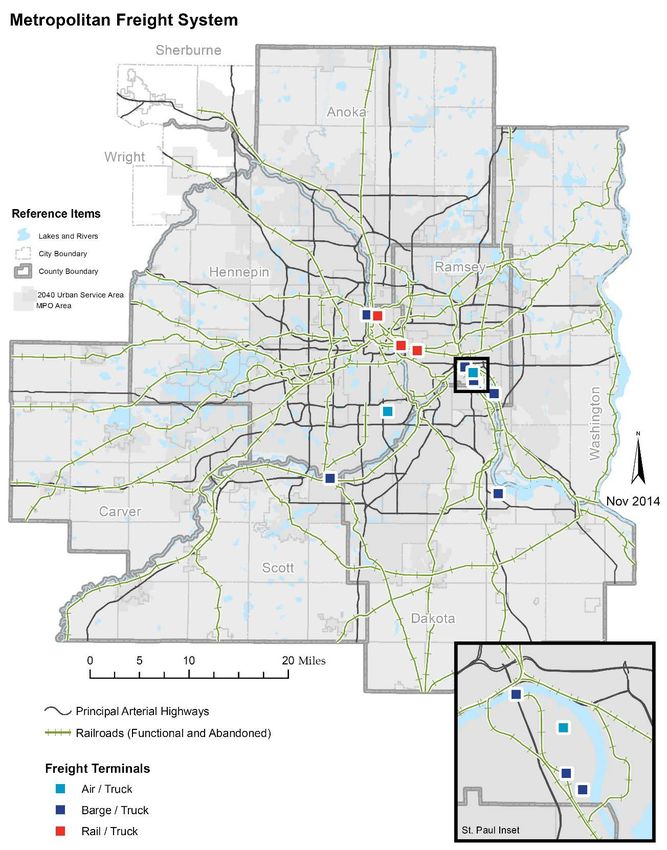
Regional Development Guide
The Council adopted Thrive MSP 2040 as the new regional
development guide on May 28, 2014. Thrive identifies five outcomes
that set the policy direction for the region’s system and policy plans.
Building on our region’s history of effective stewardship of our
resources, Thrive envisions a prosperous, equitable, and livable
region that is sustainable for today and generations to come. The
Council is directing its operations, plans, policies, programs, and
resources toward achieving this shared long-term vision.

Three principles define the Council’s approach to implementing regional policy: integration,
collaboration, and accountability. These principles reflect the Council’s roles in integrating policy
areas, supporting local governments and regional partners, and promoting and implementing the
regional vision. The principles define the Council’s approach to policy implementation and set
expectations for how the Council interacts with local governments.

Thrive also outlines seven land use policies and community designations important for local
comprehensive planning updates. The land use policies establish a series of commitments from the
Council for local governments and uses community designations to shape development policies for
communities. Community designations group jurisdictions with similar characteristics based on Urban
or Rural character for the application of regional policies. Together, the land use policies and
community designations help to implement the region’s vision by setting expectations for development
density and the character of development throughout the region.

Community Designation
Community designations group jurisdictions with similar characteristics for the application of regional
policies. The Council uses community designations to guide regional growth and development;
establish land use expectations including overall development densities and patterns; and outline the
respective roles of the Council and individual communities, along with strategies for planning for
forecasted growth. If there are discrepancies between the Thrive MSP 2040 Community Designations
Map and the Community Designation map contained herein because of adjustments and refinements
that occurred subsequent to the adoption of Thrive, communities should follow the specific guidance
contained in this System Statement.

Thrive identifies North Oaks with the community designations of Suburban and Rural Residential
(Figure 1).

Suburban communities experienced continued growth and expansion during the 1980s and early
1990s, and typically have automobile-oriented development patterns at significantly lower densities
than in previous eras. Suburban communities are expected to plan for forecasted population and
household growth at average densities of at least 5 units per acre for new development and
redevelopment. In addition, Suburban communities are expected to target opportunities for more
intensive development near regional transit investments at densities and in a manner articulated in the
2040 Transportation Policy Plan.

Rural Residential communities have residential patterns characterized by large lots and do not have
plans to provide urban infrastructure, such as centralized wastewater treatment. Many of these
communities have topographical development limitations and a development pattern with lot sizes that
generally range from 1-2.5 units per acre. Rural Residential communities are expected to discourage

Page - 3 | 2015 SYSTEM STATEMENT – NORTH OAKS                                                INTRODUCTION
future development of rural residential patterns and where opportunities exist, plan for rural
development at densities that are not greater than 1 unit per 10 acres.

Specific strategies for Suburban communities and Rural Residential communities can be found on
North Oaks’ Community Page in the Local Planning Handbook.

Forecasts
The Council uses the forecasts developed as part of Thrive to plan for regional systems. Communities
should base their planning work on these forecasts. Given the nature of long-range forecasts and the
planning timeline undertaken by most communities, the Council will maintain on-going dialogue with
communities to consider any changes in growth trends or community expectations about growth that
may have an impact on regional systems.

The Thrive forecasts for population, households, and employment for your community are:

                      2010 (actual)      2014 (est.)        2020             2030                 2040
 Population              4,469             4,793            4,790            5,000                5,200
 Households              1,746             1,824            1,900            2,030                2,100
 Employment              1,260             1,432            1,400            1,460                1,500

Housing Policy
The Council adopted the Housing Policy Plan on December 10, 2014, and amended the plan on July 8,
2015. The purpose of the plan is to provide leadership and guidance on regional housing needs and
challenges and to support Thrive MSP 2040. The Housing Policy Plan provides an integrated policy
framework to address housing challenges greater than any one city or county can tackle alone.

Consistent with state statute (Minn. Stat. 473.859, subd. 2(c) and subd. 4), communities must include a
housing element and implementation program in their local comprehensive plans that address existing
and projected housing needs.

The Council has also determined the regional need for low and moderate income housing for the
decade of 2021-2030 (see Part III and Appendix B in the Housing Policy Plan).

North Oaks’ share of the region’s need for low and moderate income housing is 44 new units affordable
to households earning 80% of area median income (AMI) or below. Of these new units, the need is for
24 affordable to households earning at or below 30% of AMI, 20 affordable to households earning 31%
to 50% of AMI, and 0 affordable to households earning 51% to 80% of AMI.

                     Affordable Housing Need Allocation for North Oaks
                     At or below 30% AMI                             24
                     31 to 50% AMI                                   20
                     51 to 80% AMI                                   0
                     Total Units                                     44

Specific requirements for the housing element and housing implementation programs of local
comprehensive plans can be found in the Local Planning Handbook.

Page - 4 | 2015 SYSTEM STATEMENT – NORTH OAKS                                                    INTRODUCTION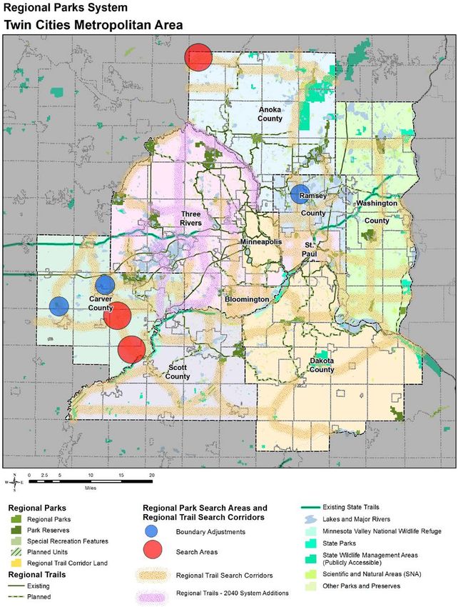
Figure 1. North Oaks Community Designation

Page - 5 | 2015 SYSTEM STATEMENT – NORTH OAKS   INTRODUCTION
TRANSPORTATION SYSTEM
                                           STATEMENT
                                                                                  City of North Oaks

The 2040 Transportation Policy Plan (TPP) is the metropolitan system plan for highways, transit, and
aviation to which local comprehensive plans must conform. This system statement summarizes
significant changes to these three systems, as well as other changes made to the Transportation Policy
Plan since the last 2030 TPP was adopted in 2010, and highlights those elements of the system plan
that apply specifically to your community. The TPP incorporates the policy direction and the new 2040
socio economic forecasts adopted by the Metropolitan Council in the Thrive MSP 2040, and extends
the planning horizon from 2030 to 2040.

Federal Requirements
The TPP must respond to requirements outlined in state statute, as well as federal law, such as some
new requirements included in the federal law known as the Moving Ahead for Progress in the 21st
Century Act (MAP-21). For instance, metropolitan transportation plans must now be performance
based, so the TPP now includes goals, objectives, and strategies outlined in chapter 2. In previous
versions of the TPP the strategies were known as policies; while some are new, the wording of many
strategies are similar to the wording of policies in previous plans. Performance measurements for this
plan are also discussed in Chapter 12, Federal Requirements.

Federal law requires the long range plan to identify regionally significant transportation investments
expected to be made over the next two decades, and to demonstrate that these planned investments
can be afforded under the plan’s financial assumptions. Both costs and available revenues have
changed since the last plan was adopted in 2010, resulting in many changes in the plan. Federal law
does allow the plan to provide a vision for how an increased level of transportation revenue might be
spent if more resources become available, but the programs or projects identified in this scenario are
not considered part of the approved plan.

The TPP includes two funding scenarios for the metropolitan highway and transit systems: the “Current
Revenue Scenario” and the “Increased Revenue Scenario.”

   •   The Current Revenue Scenario represents the fiscally constrained regional transportation
       plan, which assumes revenues that the region can reasonably expect to be available based on
       past experience and current laws and allocation formulas.
   •   The Increased Revenue Scenario represents an illustration of what be achieved with a
       reasonable increase in revenues for transportation.

Under the Metropolitan Land Planning Act, local comprehensive plans are expected to conform to the
Current Revenue Scenario, which is the official metropolitan system plan. Potential improvements in
the Increased Revenue Scenario can be identified separately in local plans as unfunded proposals. A
more detailed description of how to handle the various improvements in this category is included under
Other Plan Considerations.

In addition to reviewing this system statement, your community should consult the entire 2040
Transportation Policy Plan to ensure that your community’s local comprehensive plan and plan
amendments conform to the metropolitan transportation system plan. Chapter 3, Land Use and Local
Planning, has been expanded and all communities should carefully review this chapter. A PDF file of

Page - 6 | 2015 SYSTEM STATEMENT – NORTH OAKS                                            TRANSPORTATION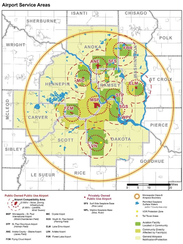
the entire 2040 Transportation Policy Plan can be found at the Metropolitan Council’s
website: http://www.metrocouncil.org/Transportation/Planning-2/Key-Transportation-Planning-
Documents/Transportation-Policy-Plan-(1)/The-Adopted-2040-TPP-(1).aspx. The format of the plan is
slightly different than past Transportation Policy Plans. An introductory Overview, Chapter 1: Existing
System and Chapter 10: Equity and Environmental Justice have been added to this version of the TPP,
in addition to the changes noted in the first paragraph. Please note some modifications have been
made to the appendices as well.

Key Changes in the 2040 Transportation Policy Plan
Adopted by the Metropolitan Council in January 2015, the revised 2040 Transportation Policy Plan
incorporates the following changes:

Metropolitan Highway System - Chapter 5
The Metropolitan Highway System is made up of principal arterials, shown in Fig 1-1 of the TPP and
also attached to this system statement. Although no new highways have been added to this system in
the 2040 TPP, the last incomplete segment of this system, TH 610, is now under construction in Maple
Grove.

    •   The TPP acknowledges that congestion cannot be eliminated or greatly reduced. The region’s
        mobility efforts will need to focus on managing congestion and working to provide alternatives.
        The majority of resources available between now and 2040 will be needed for preservation,
        management and operation of the existing highway system.

    •   Due to increased costs and decreased revenue expectations, many long-planned major projects
        to add general purpose highway lanes are not in this fiscally constrained plan. While the
        preservation, safety, and mobility needs of these corridors are recognized, investments in these
        corridors will be focused on implementing traffic management strategies, lower cost-high benefit
        spot mobility improvements, and implementing MnPASS lanes. Some specific projects have
        been identified in this plan, but funding has primarily been allocated into various investment
        categories rather than specific projects. The highway projects specifically identified in the
        Current Revenue Scenario are shown in Figure 5-8 of the TPP which is also attached to this
        system statement.

    •   Modifications were made to Appendix D - Functional Classification Criteria, and Appendix F –
        Highway Interchange Requests. Appendix C – Project List is new and contains all of the transit
        and highway projects that have been identified between 2014 and 2023.

Transit System - Chapter 6
The transit system plan provides an overview of the basic components of transit planning, including
demographic factors, transit route and network design factors and urban design factors that support
transit usage. Local governments have the primary responsibility for planning transit-supportive land
use, through their comprehensive planning, and subdivision and zoning ordinances.

•   The TPP includes updated Transit Market Areas (shown in TPP Figure 6-3, also attached) which
    reflect 2010 Census information and an updated methodology that better aligns types and levels of
    transit service to expected demand. These market areas identify the types of transit services that
    are provided within each area.

•   The TPP includes limited capital funding for transit expansion and modernization. Opportunities
    primarily exist through competitive grant programs such as the regional solicitation for US DOT

Page - 7 | 2015 SYSTEM STATEMENT – NORTH OAKS                                            TRANSPORTATION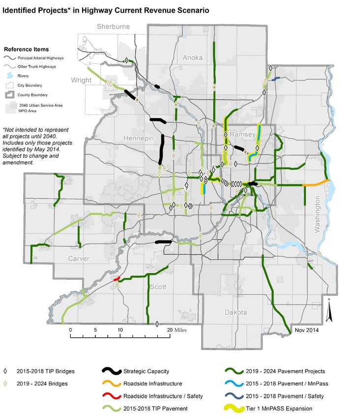
funding. These opportunities are guided by the strategies in the TPP and the various elements of
the Transit Investment Plan.
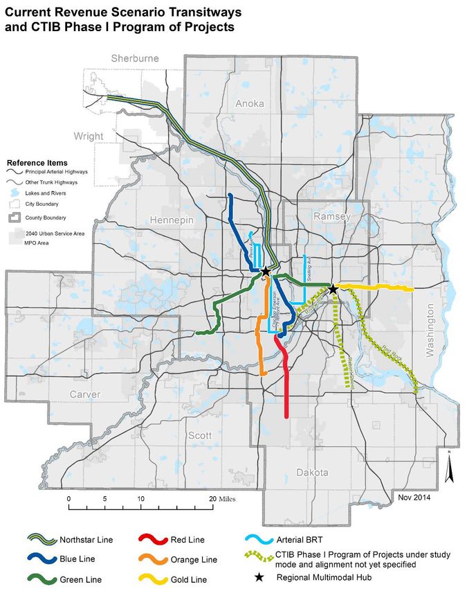
• The TPP includes an updated transitway system plan that more clearly articulates which projects
can be funded within reasonable revenue expectations through year 2040 (Current Revenue
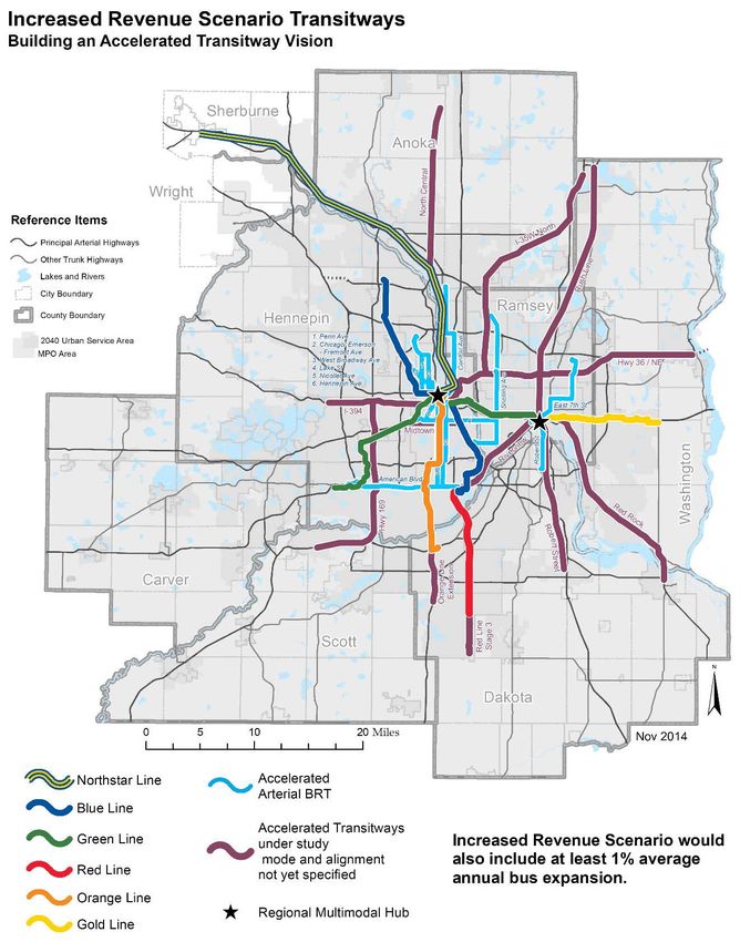
Scenario as shown in TPP Figure 6-8, which is also attached). The plan includes five new or
expanded METRO lines, three new arterial bus rapid transit lines, and three corridors under study
for mode and alignment but identified in the Counties Transit Improvement Board’s (CTIB) Phase I
Program of Projects. This system was developed in collaboration with CTIB, a major partner in
regional transitway expansion.
• The TPP does not include operating funding for transit service expansion beyond the existing
network of regular route bus, general public dial-a-ride, and Metro Vanpool.
• The Increased Revenue Scenario (shown TPP Figure 6-9, which is also attached) illustrates the
level of expansion for the bus and support system and transitway system that might be reasonable
if additional revenues were made available to accelerate construction of the transitway vision for the
region.
• The plan includes updated requirements and considerations for land use planning around the
region’s transit system. This includes new residential density standards for areas near major
regional transit investments and an increased emphasis on proactive land use planning in
coordination with the planning of the transit system.
Aviation System - Chapter 9
The Metropolitan Aviation System is comprised of nine airports (shown in Figure 1-9 of the TPP and
also attached to this system statement) and off-airport navigational aids. There are no new airports or
navigational aids that have been added to the system in the 2040 TPP.
• The TPP discusses the regional airport classification system as well as providing an overview of
roles and responsibilities in aviation for our regional and national partners. The investment plan in
includes an overview of funding sources for projects, and an overview of projects proposed for the
local airports that will maintain and enhance the regional airport system.
• Modifications were made to Appendix I – Regional Airspace, Appendix J – Metropolitan Airports
Commission Capital Investment Review Process, Appendix K – Airport Long Term Comprehensive
Plans and Appendix L – Aviation Land Use Compatibility.
Other Plan Changes
Regional Bicycle Transportation Network - Chapter 7
The 2040 TPP encourages the use of bicycles as a mode of transportation. To that end, the TPP
establishes for the first time a Regional Bicycle Transportation Network (RBTN). The goal of the RBTN
is to establish an integrated seamless network of on-street bikeways and off-road trails that
complement each other to most effectively improve conditions for bicycle transportation at the regional
level. Cities, counties, and parks agencies are encouraged to plan for and implement future bikeways
within and along these designated corridors and alignments to support the RBTN vision.
Page - 8 | 2015 SYSTEM STATEMENT – NORTH OAKS TRANSPORTATION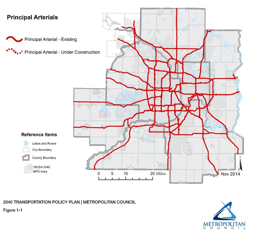
Freight - Chapter 8
Most aspects of freight movement are controlled by the private sector, so unlike other sections of the
TPP, there is not a specific plan adopted for future public sector investment in freight facilities.
However, the discussion of the need for a safe and efficient multimodal freight system has been
updated and expanded in the TPP to recognize challenges and opportunities for freight movement as
well as the future direction of freight by mode. It acknowledges the closure of the Minneapolis Upper
Harbor in 2015, leaving St Paul and Shakopee as the region’s major barge terminal areas in the future.
The plan also acknowledges the increase of trains since 2010 carrying oil from North Dakota on BNSF
and CP rail tracks, which is expected to continue into the future. Although railroad trackage in the
region was significantly decreased over the last 20 years to “right size” the system after federal
deregulation, communities should not expect much additional rail abandonment. Many tracks that
appear to be seldom used are owned by the smaller Class III railroads that serve local businesses by
providing direct rail connections from manufacturing and warehousing/distribution facilities to the major
national railroads. The major Class I railroads are approaching capacity and actually adding tracks in
some locations.

System Plan Considerations Affecting Your Community
North Oaks should consult the complete 2040 Transportation Policy Plan in preparing its local
comprehensive plan. In addition, North Oaks should consult Thrive MSP 2040 and the current version
of the Metropolitan Council’s Local Planning Handbook for specific information needed in its
comprehensive plan. Specific system plan considerations affecting North Oaks are detailed below.

Metropolitan Highways
There are no principal arterials located within North Oaks.

Transit System
North Oaks includes the following Transit Market Areas:

 Transit Market      Market Area Description and Typical Transit Services
 Area

 Market Area IV      Transit Market Area IV has lower concentrations of population and employment
                     and a higher rate of auto ownership. It is primarily composed of Suburban Edge
                     and Emerging Suburban Edge communities. This market can support peak-period
                     express bus services if a sufficient concentration of commuters likely to use
                     transit service is located along a corridor. The low-density development and
                     suburban form of development presents challenges to fixed-route transit. General
                     public dial-a-ride services are appropriate in Market Area IV.

North Oaks should identify and map existing transit services and facilities in the local comprehensive
plan. North Oaks should also work with transit providers serving their community to identify potential
future transit service options and facilities that are consistent with the TPP and the applicable Transit
Market Areas. Communities can find further maps and guidance for transit planning in the
Transportation section of the Local Planning Handbook.

Transitways
Current Revenue Scenario Transitways
The TPP’s Transit Investment Plan does not show any transitway investments planned for North Oaks
in the Current Revenue Scenario (TPP Figure 6-8).

Page - 9 | 2015 SYSTEM STATEMENT – NORTH OAKS                                               TRANSPORTATION
Increased Revenue Scenario Transitways The TPP Increased Revenue Scenario shows additional transitway corridors beyond the scope of the plan’s adopted and fiscally constrained Transit Investment Plan (the Current Revenue Scenario). These corridors are listed on page 6.63 of the TPP, and TPP Figure 6-9, which is attached, shows the complete transitway vision for the region. If North Oaks believes it might be directly impacted by transitways in the Increased Revenue Scenario (for example, because they are participating in transitway corridor studies or feasibility analyses), the transitways may be acknowledged in the Comprehensive Plan. These additional corridors are or will be under study for mode and alignment recommendations, but they are not included in fiscally constrained plan. However, they should be clearly identified as not funded within the currently expected resources for transitways. The Council recognizes the important planning work that goes into a corridor prior to it becoming part of the region’s Transit Investment Plan, especially if increased revenues were to become available. Similar to Current Revenue Scenario Transitways, communities should identify known potential stations along planned transitways and consider guiding land use policies, station area plans, and associated zoning, infrastructure, and implementation tools that support future growth around transit stations. These policies can also influence station siting in initial planning phases of transitway corridors and influence the competitiveness of a transitway for funding. Communities can find further guidance for station area planning in the Transportation section of the Local Planning Handbook and the Transit Oriented Development Guide. Aviation All communities must include an aviation element in the transportation sections of their comprehensive plans. The degree of aviation planning and development considerations that need to be included in the comprehensive plan varies by community. Even those communities not impacted directly by an airport have a responsibility to include airspace protection in their comprehensive plan. The protection element should include potential hazards to air navigation including electronic interference. North Oaks is not in an influence area of a regional airport. Airspace protection should be included in local codes/ordinances to control height of structures. Other Plan Considerations Regional Bicycle Transportation Network TPP Figure 7-1 shows the RBTN as established for the first time in the 2040 TPP. The network consists of a series of prioritized Tier 1 and Tier 2 corridors and dedicated alignments (routes). The process used to develop the RBTN, as well as the general principles and analysis factors used in its development, can be found in the Bicycle and Pedestrian Chapter of the TPP. The RBTN corridors and alignments make up the “trunk arterials” of the overall system of bikeways that connect to regional employment and activity centers. These are not intended to be the only bicycle facilities in the region, and local units should also consider planning for any additional bike facilities desired by their communities. RBTN corridors are shown where more specific alignments within those corridors have not yet been designated, so local governments are encouraged to use their comprehensive planning process to identify suitable alignments within the RBTN corridors for future incorporation into the TPP. Page - 10 | 2015 SYSTEM STATEMENT – NORTH OAKS TRANSPORTATION
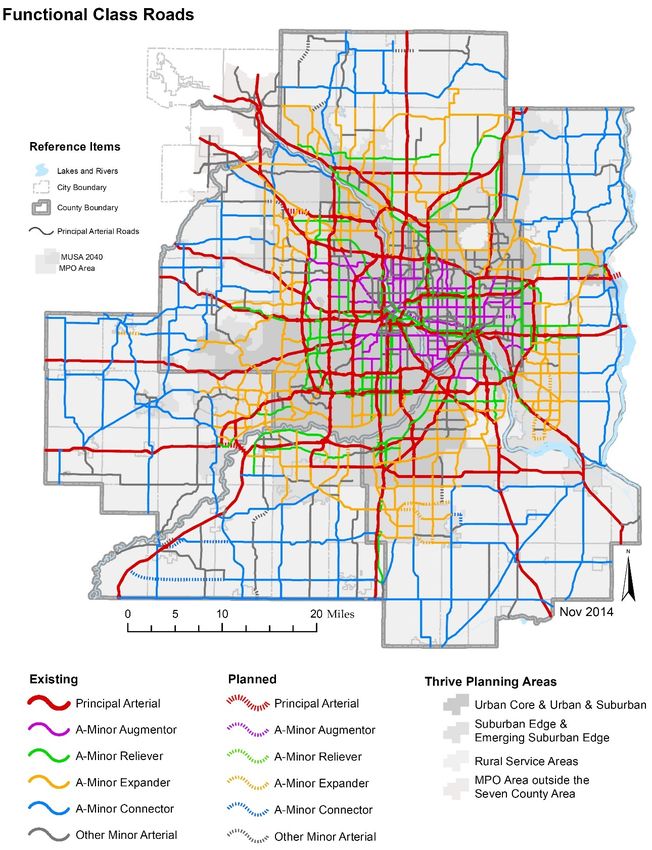
In addition, agencies should plan their local on and off-road bikeway networks to connect to the
designated Tier 1 and Tier 2 alignments, as well as any new network alignments within RBTN corridors
to be proposed in local comprehensive plans. Bikeway projects that complete segments of, or connect
to, the RBTN are given priority for federal transportation funds through the Transportation Advisory
Board’s biannual regional solicitation.

Figure 7-1 shows that your community currently has one or more RBTN corridors and alignments within
its jurisdiction. The Council encourages local governments to incorporate the RBTN map within their
local bicycle plan maps to show how the local and regional systems are planned to work together. An
on-line interactive RBTN map, which allows communities to view the RBTN links in their community at a
much more detailed scale than Figure 7-1, can be found in the Transportation section of the Local
Planning Handbook. The handbook also includes best practices, references, and guidance for all local
bicycle planning.

A Minor System / Functional Classification
The TPP has always recognized the A minor arterial system as an important supplement to the regional
highway system, and the Transportation Advisory Board (TAB) continues to maintain the official
regional map of these roads. The 2040 TPP does include an updated functional classification map (Fig.
1-2 in Chapter 1) and a modified Appendix D - Functional Classification Criteria. Communities should
consult the Local Plan Handbook for more information on functional classification, how to reflect the A
minor arterial system in their plan, and how to request functional classification changes if necessary.

Freight
The Council encourages all local governments to plan for freight movement in their communities.
Trucks are the major mode of freight movement in the region and across the nation to distribute
consumer goods as well as move manufactured goods and commodities, and they operate in every
community.

Communities with special freight facilities shown on TPP Figure 8-1, Metropolitan Freight System,
(attached) should also include those additional modes and facilities in their local plan, and plan for
compatible adjacent land uses.

Page - 11 | 2015 SYSTEM STATEMENT – NORTH OAKS                                              TRANSPORTATION
Figure 1-1 of the TPP

Page - 12 | 2015 SYSTEM STATEMENT – NORTH OAKS   TRANSPORTATION
Figure 1-2 of the TPP

Page - 13 | 2015 SYSTEM STATEMENT – NORTH OAKS   TRANSPORTATION
Figure 5-8 of the TPP

Page - 14 | 2015 SYSTEM STATEMENT – NORTH OAKS   TRANSPORTATION
Figure 6-3 of the TPP

Page - 15 | 2015 SYSTEM STATEMENT – NORTH OAKS   TRANSPORTATION
Figure 6-8 of the TPP

Page - 16 | 2015 SYSTEM STATEMENT – NORTH OAKS   TRANSPORTATION
Figure 6-9 of the TPP

Page - 17 | 2015 SYSTEM STATEMENT – NORTH OAKS   TRANSPORTATION
Figure 7-1 of the TPP

Page - 18 | 2015 SYSTEM STATEMENT – NORTH OAKS   TRANSPORTATION
Figure 8-1 of the TPP

Page - 19 | 2015 SYSTEM STATEMENT – NORTH OAKS   TRANSPORTATION
Figure 9-1 of the TPP

Page - 20 | 2015 SYSTEM STATEMENT – NORTH OAKS   TRANSPORTATION
WATER RESOURCE REQUIREMENTS/
       WASTEWATER SYSTEM STATEMENT
                                                                                  City of North Oaks

The 2040 Water Resources Policy Plan includes policies and strategies to achieve the following goal:

   To protect, conserve, and utilize the region’s groundwater and surface water in ways that protect
   public health, support economical growth and development, maintain habitat and ecosystem health,
   and provide for recreational opportunities, which are essential to our region’s quality of life.

The Policy Plan takes an integrated approach to water supply, water quality, and wastewater issues.
This approach moves beyond managing wastewater and stormwater only to meet regulatory
requirements by viewing wastewater and stormwater as resources, with the goal of protecting the
quantity and quality of water our region needs now and for future generations.

The Policy Plan includes policies and strategies to:

   •   Maximize regional benefits from regional investments in the areas of wastewater, water supply
       and surface water.
   •   Pursue reuse of wastewater and stormwater to offset demands on groundwater supplies.
   •   Promote greater collaboration, financial support, and technical support in working with partners
       to address wastewater, water quality, water quantity and water supply issues.
   •   Implement environmental stewardship in operating the regional wastewater system by reusing
       wastewater, reducing energy use and air pollutant emissions, and reducing, reusing, and
       recycling solid waste.

Key Concepts in the 2040 Water Resources Policy Plan
Adopted by the Metropolitan Council in May 2015, the 2040 Water Resources Policy Plan is the
metropolitan system plan for metropolitan wastewater services with which local comprehensive plans
must conform. The Policy Plan incorporates the following changes:

• Centers on and around an integrated approach to water supply, wastewater, and surface water
  planning.
• Promotes the investigation of the issues and challenges in furthering our work in water conservation,
  wastewater and stormwater reuse, and low impact development practices in order to promote a
  more sustainable region.
• Promotes the concept of sustainable water resources where, through collaboration and cooperation,
  the region will take steps to manage its water resources in a sustainable way aimed at:
  o Providing an adequate water supply for the region
  o Promoting and implementing best management practices that protect the quality and quantity of
      our resources
  o Providing efficient and cost effective wastewater services to the region
  o Efficiently addressing nonpoint and point sources pollution issues and solutions, and,
  o Assessing and monitoring lakes, rivers, and streams so that we can adequately manage, protect,
      and restore our valued resources.
• Continues the Council’s position that communities that permit the construction and operation of
  subsurface sewage treatment systems and other private wastewater treatment systems are

Page - 21 | 2015 SYSTEM STATEMENT – NORTH OAKS                                         WATER RESOURCES
responsible for ensuring that these systems are installed, maintained, managed and regulated consistent with Minnesota Rules Chapter 7080-7083. • Includes requirements in Appendix C for comprehensive sewer plans, local water plans, and local water supply plans. • Establishes inflow and infiltration goals for all communities served by the regional wastewater system and requires all communities to include their inflow and infiltration mitigation programs in their comprehensive sewer plan. • Works with the State to attempt to (1) make funds available for inflow and infiltration mitigation, and (2) promote statutes, rules, and regulations to encourage I/I mitigation. North Oaks should consult the complete Policy Plan in preparing its local comprehensive plan. In addition, North Oaks should consult Thrive MSP 2040 and the Local Planning Handbook for specific information needed in its comprehensive plan. System Plan Considerations Affecting Your Community Metropolitan Sewer Service Under state law (Minn. Stat. 473.513) local governments are required to submit both a wastewater plan element to their comprehensive plan as well as a comprehensive sewer plan describing service needs from the Council. Specific requirements for the sewer element of your comprehensive plan can be found in the Water Resources section of the Local Planning Handbook. Forecasts The forecasts of population, households, employment, and wastewater flows for North Oaks as contained in the adopted 2040 Water Resources Policy Plan can be found at: http://www.metrocouncil.org/Wastewater-Water/Planning/2040-Water-Resources-Policy-Plan.aspx and on your Community Page in the Local Planning Handbook. These forecasts are for sewered development. The sewered housing forecasts were estimated using SAC data, annual city reports, current trends, existing and future local wastewater service areas and other information relating to your community. The wastewater flows are based on historical wastewater flow data, future projected wastewater generation rates, and the projected sewered population and employment data. The Council will use these growth and wastewater flow forecasts to plan future interceptor and treatment works improvements needed to serve your community. The Council will not design future interceptor improvements or treatment facilities to handle peak hourly flows in excess of the allowable rate for your community. North Oaks, through its comprehensive planning process, must decide the location and staging of development, and then plan and design its local wastewater collection system to serve this development. The Council will use its judgment as to where to assign growth within your community to determine regional system capacity adequacy. If North Oaks wishes to identify specific areas within the community to concentrate its growth, it should do so within its Comprehensive Sewer Plan. You should also note that urban development at overall densities that are substantially lower than those identified for your community in the Community Designation Section of this Systems Statement will also be analyzed by the Council for their potential adverse effects on the cost of providing metropolitan sewer service. Description of the Metropolitan Disposal System Serving Your Community Figure 1 shows the location of the Metropolitan Disposal System (MDS) serving your community. Wastewater flow from North Oaks is treated at the Metropolitan WWTP. Page - 22 | 2015 SYSTEM STATEMENT – NORTH OAKS WATER RESOURCES
Description of the Regional Inflow/Infiltration (I/I) Program
The 2040 Water Resources Policy Plan states that the Council will establish I/I goals for all
communities discharging wastewater to the MDS. Communities that have excessive I/I in their sanitary
sewer systems will be required to eliminate excessive I/I. The Council will continue the implementation
of its on-going I/I reduction program. Communities identified through the program as needing to
eliminate excessive I/I will be required to submit a work plan that details work activities to identify and
eliminate sources of I/I. The Council can limit increases in service within those communities having
excess I/I that do not demonstrate progress in reducing their excess I/I. The Council will meet with the
community and discuss this alternative before it is implemented.

It is required that those communities that have been identified as contributors of excessive I/I, and that
have not already addressed private property sources, do so as part of their I/I program. Significant work
has been accomplished on the public infrastructure portion of the wastewater system. The Council will
pursue making funds available through the State for I/I mitigation, and promote statutes, rules and
regulations to encourage I/I mitigation.

Management of Subsurface Sewage Treatment Systems (SSTS) and Private
Systems
The Metropolitan Land Planning Act requires the sewer element of the local comprehensive plan to
describe the standards and conditions under which the installation of subsurface sewage treatment
systems and other private wastewater treatment systems will be permitted and to the extent
practicable, the areas not suitable for public or private systems.

The appropriate density for development with subsurface sewage treatment systems depends on the
suitability of the soils to treat wastewater and whether space is available for a primary and back up
drainfield. It is the Council’s position that all municipalities and counties allowing subsurface sewage
treatment systems should incorporate current MPCA regulations (Minn. Rules Chapter 7080-7083) as
part of a program for managing subsurface sewage treatment systems in the sewer element of their
local comprehensive plan and implement the standards in issuing permits.

North Oaks should adopt a management program consistent with state rules. An overview of North
Oaks’s management program must be included in the community’s local comprehensive plan update. If
adequate information on the management program is not included; the comprehensive plan will be
found incomplete for review until the required information is provided to the Council. Specific
requirements for the local comprehensive plan can be found in the Local Planning Handbook.

Small private treatment plants are located throughout the Metropolitan Area serving such developments
as individual industries, mobile home parks, and other urban type uses. The Council’s position is that
such private wastewater treatment plants should be permitted only if they are in areas not programmed
for metropolitan sewer service in the future and they are provided for in a community’s comprehensive
plan that the Council has approved. Furthermore, the community is responsible for permitting all
community or cluster wastewater treatment systems consistent with Minnesota Rules Chapter 7080-
7083 and MPCA standards. The Council will not provide financial support to assist communities if these
systems fail.

North Oaks should include in the sewer element of its local comprehensive plan the conditions under
which private treatment plants or municipal treatments would be allowed, and include appropriate
management techniques sufficiently detailed to ensure that the facilities conform to permit conditions.
North Oaks is responsible for ensuring that permit conditions for private treatment plants are met and
financial resources to manage these facilities are available.

Page - 23 | 2015 SYSTEM STATEMENT – NORTH OAKS                                            WATER RESOURCES
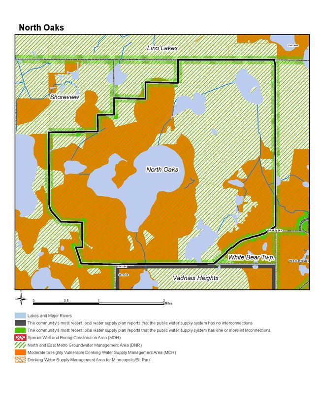
Surface Water Management
In 1995, Minnesota Statutes Section 473.859, subd. 2 was amended to make the local water plan
(often referred to as local surface water management plans) required by section 103B. 235 a part of the
land use plan of the local comprehensive plan. Minnesota Rules Chapter 8410, updated in July of 2015,
includes the requirements for local water management plans. The main change that you need to be
aware of is that all communities in the metropolitan area must update their local water plan between
January 1, 2017 and December 31, 2018. This means that North Oaks must update its local water plan
as part of the comprehensive plan update. The community’s updated local water plan should be
submitted to the Council for its review concurrent with the review by the Watershed Management
Organization(s) within whose watershed(s) the community is located. Failure to have an updated
local water plan will result in the comprehensive plan being found incomplete for review until
the required plan is provided to the Council.

Local water plans must meet the requirements for local water plans in Minnesota Statutes, section
103B.235 and Minnesota Rules Chapter 8410. In general, local surface water plans need to include a
summary of the priorities and problems in the community; structural, nonstructural and programmatic
actions to take to address the priorities and problems; and clearly identified funding mechanisms to fix
the problems.
More detailed guidance for the local water plans can be found in Appendix C of the Council’s 2040
Water Resources Policy Plan and in the Council’s current Local Planning Handbook.

In addition, the Council has also updated its priority lake list that was first developed in the 1980s as
part of the Water Resources Policy Plan update. Figure 2 shows the priority lakes for North Oaks. The
Council uses the priority lake list to focus its limited resources. The list is also used in the environmental
review process. Where a proposed development may impact a priority lake, the project proposer must
complete a nutrient budget analysis for the lake as part of the environmental review process.

Also included on Figure 2 is the watershed organization(s) that North Oaks is part of and a list of
impaired waters in the community for use in development of your local water plans.

Other Plan Considerations
Water Supply
Local comprehensive plans also address water supply (Minn. Stat., Sec. 473.859). For communities in
the metropolitan area with municipal water supply systems, this local comprehensive plan requirement
is met by completing the local water supply plan template, which was jointly developed by the
Metropolitan Council and the Minnesota Department of Natural Resource (DNR).

FOR COMMUNITIES WITHOUT PUBLIC WATER SUPPLIES:

Because your community relies primarily on private wells and does not own/operate a municipal
community public water supply system (PWS), you do not need to prepare a local water supply plan.
However, your updated local comprehensive plan should include information about water sources,
including plans to protect private water supplies, in appropriate sections of the local comprehensive
plan.

FOR COMMUNITIES WITH PUBLIC WATER SUPPLY SYSTEMS OWNED BY ANOTHER ENTITY

Because a small portion of your community uses a municipal community public water supply system
(PWS) that is not owned/operated by your community, you should collaborate with the owner of the

Page - 24 | 2015 SYSTEM STATEMENT – NORTH OAKS                                              WATER RESOURCES
PWS to ensure their local water supply plan reflects your water demand. Potential water supply issues
should be acknowledged, monitoring and conservation programs should be developed, and
approaches to resolve any issues should be identified.

You should submit the updated local water supply plan developed by the PWS that serves your
community along with your local comprehensive plan update.

Failure to have an updated local water plan will result in the comprehensive plan being found
incomplete for review until the required plan is provided to the Council.

The local water supply plan will be adopted by your community as part of the local comprehensive plan.

Guidance and information for water supply planning can be found in the Appendix C of the 2040 Water
Resources Policy Plan, the Local Planning Handbook, and the Council’s Master Water Supply Plan.

The Council’s Master Water Supply Plan provides communities in the region with planning assistance
for water supply in a way that:

   •   Recognizes local control and responsibility for owning, maintaining and operating water systems
   •   Is developed in cooperation and consultation with municipal water suppliers, regional
       stakeholders and state agencies
   •   Protects critical habitat and water resources over the long term
   •   Meets regional needs for a reliable, secure water supply
   •   Highlights the benefits of integrated planning for stormwater, wastewater and water supply
   •   Emphasizes and supports conservation and inter-jurisdictional cooperation
   •   Provides clear guidance by identifying key challenges/issues/considerations in the region and
       available approaches without dictating solutions

Figures 3-5 illustrate some water supply considerations that the community may consider as they
develop their local water supply plans, such as: aquifer water levels, groundwater and surface water
interactions, areas where aquifer tests or monitoring may be needed to reduce uncertainty, regulatory
and management areas, and emergency interconnections.

Page - 25 | 2015 SYSTEM STATEMENT – NORTH OAKS                                        WATER RESOURCES
Figure 1. MCES Sanitary Sewer Meter Service Areas Page - 26 | 2015 SYSTEM STATEMENT – NORTH OAKS WATER RESOURCES
Figure 2. Surface Water Resources

Page - 27 | 2015 SYSTEM STATEMENT – NORTH OAKS   WATER RESOURCES
Figure 3. Surface water features and interaction with the regional groundwater system, and state-protected surface water features

Page - 28 | 2015 SYSTEM STATEMENT – NORTH OAKS                                                                WATER RESOURCES
Figure 4. Availability of MN Department of Natural Resources groundwater level and MN Department of Health aquifer test data

Page - 29 | 2015 SYSTEM STATEMENT – NORTH OAKS                                                              WATER RESOURCES
Figure 5. Municipal public water supply system interconnections and regulatory management areas

Page - 30 | 2015 SYSTEM STATEMENT – NORTH OAKS                                                    WATER RESOURCES
REGIONAL PARKS SYSTEM
                                             STATEMENT
                                                                                     City of North Oaks

The Regional Parks System includes 62 regional parks, park reserves, and special recreation features,
plus more than 340 miles of regional trails that showcase the unique landscapes of the region and
provide year-round recreation. The Regional Parks System is well-loved by our region’s residents and
attracted over 48 million annual visits in 2014.

The organizational structure of the Regional Parks System is unique, built upon a strong partnership
between the Council and the ten regional park implementing agencies that own and operate Regional
Parks System units. The regional park implementing agencies are:

            Anoka County                                Ramsey County
            City of Bloomington                         City of Saint Paul
            Carver County                               Scott County
            Dakota County                               Three Rivers Park District
            Minneapolis Park and Recreation Board       Washington County

The 2040 Regional Parks Policy Plan was developed based on furthering the Thrive MSP 2040
outcomes of Stewardship, Prosperity, Equity, Livability, and Sustainability. Thrive MSP 2040 states that
the Council will collaborate with the Metropolitan Parks and Open Space Commission, the regional park
agencies, and state partners to:

   •   Expand the Regional Parks System to conserve, maintain, and connect natural resources
       identified as being of high quality or having regional importance, as identified in the 2040
       Regional Parks Policy Plan.
   •   Provide a comprehensive regional park and trail system that preserves high-quality natural
       resources, increases climate resiliency, fosters healthy outcomes, connects communities, and
       enhances quality of life in the region.
   •   Promote expanded multimodal access to regional parks, regional trails, and the transit network,
       where appropriate.
   •   Strengthen equitable usage of regional parks and trails by all our region’s residents, such as
       across age, race, ethnicity, income, national origin, and ability.

Key Concepts in the 2040 Regional Parks Policy Plan
The 2040 Regional Parks Policy Plan includes the following policies, each with specific associated
strategies:

   •   Recreation Activities and Facilities Policy: Provide a regional system of recreation
       opportunities for all residents, while maintaining the integrity of the natural resource base within
       the Regional Parks System.

Page - 31 | 2015 SYSTEM STATEMENT – NORTH OAKS                                              REGIONAL PARKS
• Siting and Acquisition Policy: Identify lands with high-quality natural resources that are
desirable for Regional Parks System activities and put these lands in a protected status so they
will be available for recreational uses and conservation purposes in perpetuity.
• Planning Policy: Promote master planning and help provide integrated resource planning
across jurisdictions.
• Finance Policy: Provide adequate and equitable funding for the Regional Parks System units
and facilities in a manner that provides the greatest possible benefits to the people of the region.
• System Protection Policy: Protect public investment in acquisition and development by
assuring that every component in the system is able to fully carry out its designated role as long
as a need for it can be demonstrated.
The 2040 Regional Parks Policy Plan is the metropolitan system plan for regional recreation open
space with which local comprehensive plans must conform. This system statement highlights the
elements of the system plan which apply specifically to your community. Find the complete text of the
2040 Regional Parks Policy Plan on the Council’s website.
2040 Regional Parks System Facilities
The Regional Parks System is comprised of four main types of facilities: regional parks, park reserves,
special recreation features and regional trails.
Regional Parks
Regional parks most notably contain a diversity of nature-based resources, either naturally occurring or
human-built, and are typically 200-500 acres in size. Regional parks accommodate a variety of passive
recreation activities.
Park Reserves
Park reserves, like regional parks, provide for a diversity of outdoor recreation activities. One major
feature that distinguishes a park reserve from a regional park is its size. The minimum size for a park
reserve is 1,000 acres. An additional characteristic of park reserves is that up to 20 percent of the park
reserve can be developed for recreational use, with at least 80 percent of the park reserve to be
managed as natural lands that protect the ecological functions of the native landscape.
Special Recreation Features
Special recreation features are defined as Regional Parks System opportunities not generally found in
the regional parks, park reserves or trail corridors. Special recreation features often require a unique
managing or programming effort.
Regional Trails
Regional trails are classified as 1) destination or greenway trails and 2) linking trails. Destination or
greenway trails typically follow along routes with high-quality natural resources that make the trail itself
a destination. Linking trails are predominately intended to provide connections between various
Regional Parks System facilities, most notably regional parks or park reserves.
Page - 32 | 2015 SYSTEM STATEMENT – NORTH OAKS REGIONAL PARKS2040 Regional Parks System Components
The 2040 Regional Parks Policy Plan identifies six components which together comprise the vision for
the Regional Parks System in 2040, as described below.
Existing Regional Parks System Facilities: include Regional Parks System Facilities that are
open for public use. These facilities include land that is owned by regional park implementing agencies,
and may include inholding parcels within the boundaries of these parks and trail corridors that have not
yet been acquired. Existing regional trails may include planned segments that will be developed in the
future.
Planned Regional Parks System Facilities (not yet open to the public): include Regional
Parks System Facilities that have a Council-approved master plan and may be in stages of acquisition
and development, but are not yet open for public use.
Regional Parks System Boundary Adjustments: include general areas identified as potential
additions to existing Regional Parks System Facilities to add recreational opportunities or protect
natural resources. Specific adjustments to park or trail corridor boundaries have not yet been planned.
Regional Park Search Areas: include general areas for future regional parks to meet the
recreational needs of the region by 2040 where the regional park boundary has not yet been planned.
Regional Trail Search Corridors: include proposed regional trails to provide connections between
Regional Parks System facilities where the trail alignment has not yet been planned.
2040 Regional Trail Search Corridor System Additions: include regional trail search corridors
that were added to the Regional Parks System as part of the 2040 Regional Parks Policy Plan.
Key Changes in the 2040 Regional Parks Policy Plan
Adopted by the Metropolitan Council in February 2015, the 2040 Regional Parks Policy Plan
incorporates the following changes:
Identify all proposed regional trails as regional trail search corridors
All proposed regional trails that are not yet open to the public and do not have a Metropolitan Council
approved master plan are represented as a general regional trail search corridor. The 2030 Regional
Parks Policy Plan depicted these trails with a proposed alignment. The alignment of these regional
trails will be determined in the future through a planning process led by the regional park implementing
agency. The alignment of these trails is subject to Metropolitan Council approval of a regional trail
master plan.
Acquire and develop ten new regional trails or trail extensions to meet the needs of the
region in 2040. The 2040 Regional Trail Search Corridor Additions include:
Carver County:
• County Road 61
• Highway 41
Page - 33 | 2015 SYSTEM STATEMENT – NORTH OAKS REGIONAL PARKSThree Rivers Park District:
• CP Rail Extension
• Dakota Rail Extension
• Lake Independence Extension
• Lake Sarah Extension
• Minnetrista Extension
• North-South 1
• North-South 2
• West Mississippi River
The 2040 Regional Parks System Plan Map is depicted in Figure 1. North Oaks should consult the
complete 2040 Regional Parks Policy Plan in preparing its local comprehensive plan. In addition, North
Oaks should consult Thrive MSP 2040 and the current version of the Metropolitan Council’s Local
Planning Handbook for specific information needed in its comprehensive plan.
System Plan Considerations Affecting Your Community
Regional Parks System Components in your community
There are no Regional Parks System Components within North Oaks as identified in the 2040 Regional
Parks Policy Plan. North Oaks must state this fact in its comprehensive plan.
Page - 34 | 2015 SYSTEM STATEMENT – NORTH OAKS REGIONAL PARKSYou can also read