TRIP PLANNER FOR MUSLIM TOURISTS
←
→
Page content transcription
If your browser does not render page correctly, please read the page content below
3rd Open Data Challenge for Public Transportation in Tokyo
TRIP PLANNER FOR MUSLIM TOURISTS
NIPPON KOEI R&D Center
1. Entrant's name: NIPPON KOEI R&D Center
2. Submission's title: Trip Planner for Muslim Tourists
3. Description of the submission:
This is an idea report about a web service for helping Muslim tourists visiting Tokyo to
arrange their daily trips according to mosque locations, prayer times and restaurant
locations that provide Muslim-friendly (halal) dishes.
With the approaching 2020 Tokyo Olympics and Paralympics, Japan prepares to welcome
40 million tourists next year. Among them, more than one million are expected to be from
Muslim countries. Muslims have strict dietary requirements (such as they cannot consume
pork or alcoholic drinks) and they need to find prayer spaces to perform daily prayers (five
times a day). Japan is making an extra effort to become a touristic destination for Muslims
by providing prayer rooms at stations and airports, by preparing local maps indicating halal
restaurants, etc. But, accessing this information and arranging travel plans accordingly is
still a hurdle.
This web service will bring together information about halal restaurants, mosques as well
as public transport and help Muslim tourists not only to locate mosques, prayer rooms
and restaurants, but also to arrange their trips with the use of public transport in Tokyo.
All necessary information will be gathered using open data or crowdsourcing through
social media like Facebook and Twitter.
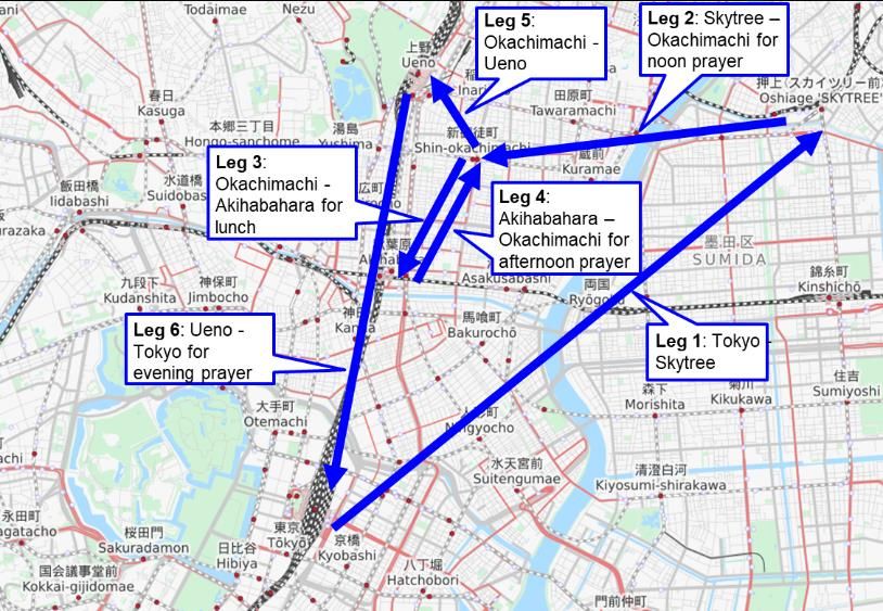
An example trip plan for visiting Skytree and Ueno Park, starting from Tokyo Station is
shown in Figure 1.
Figure 1: Trip plan example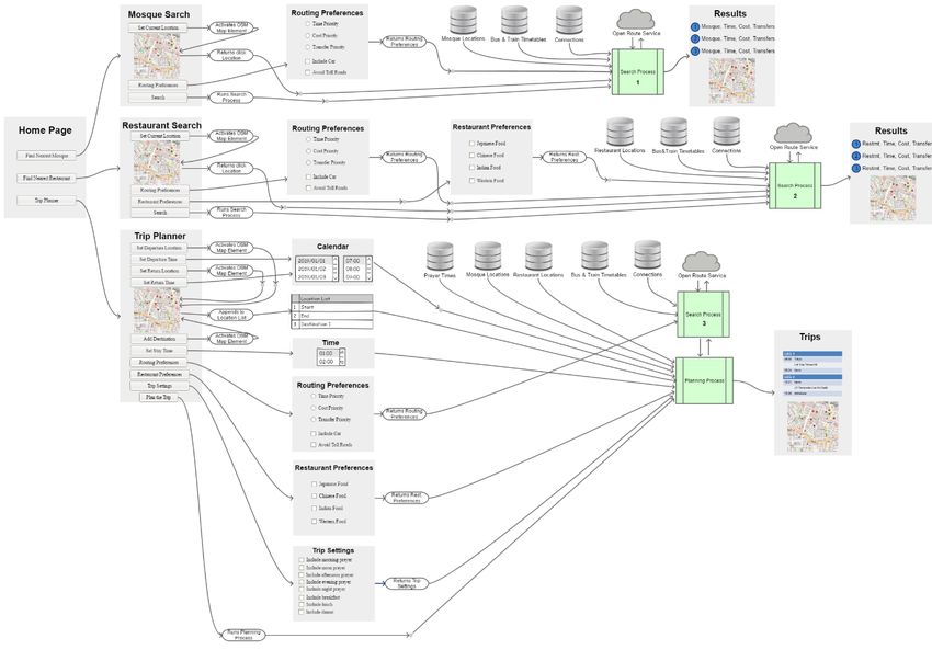
4. Used API and Data type:
 Timetable database         Timetable database of railway stations and bus stops will be
                            generated using Public Transportation Data API and will be
                            updated regularly.
 Railway stations and Location database of railway stations, bus stops and served routes
 bus stops database   will be generated using Public Transportation Data API. This
                      database will be useful for finding nearest bus stop and railway
                      station.
 Connections database       A connections database covering all railway stations and bus
                            stops will be generated in network graph form using Public
                            Transportation Data API. This database will be used to find
                            alternative paths between a departure and destination pair. It will
                            be updated regularly together with the timetable database.
 Openrouteservice API       In the case that nearest mosque or restaurant is within a walking
                            distance, a free-to-use service, Openrouteservice API
                            (https://openrouteservice.org) will be used to calculate walking
                            distance and duration.
 Mosque database            Locations of mosques, masjids and prayer rooms in Tokyo as well
                            as their operating hours will be obtained by asking social media
                            users, who follow accounts related with Muslims in Japan, to
                            share information
 Prayer times database      Prayer times database will be generated using free-to-use Prayer
                            Times API (https://aladhan.com/prayer-times-api).
 Restaurant database        Locations of restaurants that provide halal dishes in Tokyo as well
                            as types of the restaurant (Japanese, Indian, western etc.) and
                            their operating hours will be obtained by asking social media
                            users, who follow accounts related with Muslims in Japan, to
                            share information
 OpenStreetMap              We will use OpenStreetMap service, a free-to-use service,
                            (https://www.openstreetmap.org) to display maps and to get
                            onclick locations.

10. Detailed description:
    Outline of the system: is shown in Figure 2. It consists of 3 search processes and a planning
    process. Users will access to this service through their PCs, tablets or mobile phones.
    There will be 3 menu items as ‘Find nearest mosque’, ‘Find nearest restaurant’ and ‘Trip
    planner’. ‘Find nearest mosque’ menu will ask the user to set location and routing
    preferences. Then the service will return a list of 3 nearest mosques according to travel
    time using mosque database and public transport timetables. ‘Find nearest restaurant’
    menu will ask the user to set location, routing preferences and restaurant preferences.
    Then the service will return a list of 3 nearest restaurants according to travel time using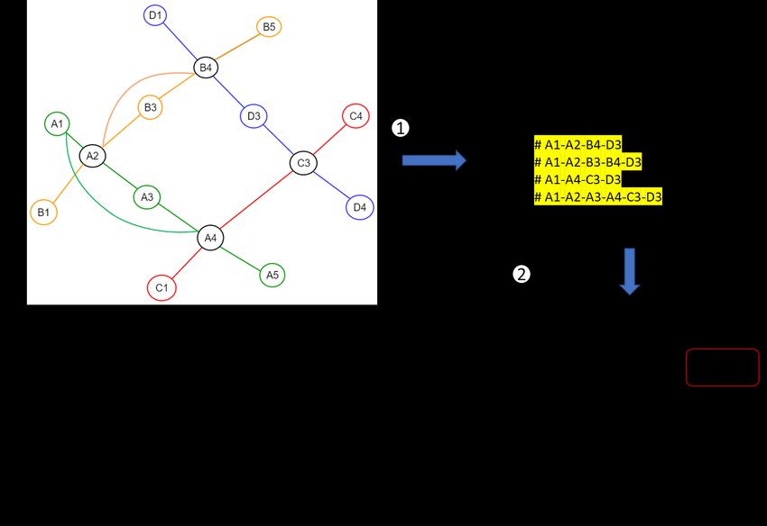
restaurant database and public transport timetables. ‘Trip planner’ menu will ask the user
to set departure location & time, return location & time, destinations to visit & stay times,
trip settings, routing preferences and restaurant preferences. Then the service will return
a trip plan to visit destinations, to perform prayers at mosques within prayer times (using
a prayer times database) and to have meals at restaurants at specified times.
Flow charts of mosque search process and planning process are given in Figure 3 and 4.

                              Figure 2: Outline of the system
Figure 3: Mosque search process
Figure 4: Trip plan process

Route search algorithm: Route search algorithm between given origin destination points
(bus stops or rail stations) is explained in Figure 5. First, several route alternatives between
origin and destination points are extracted using connections graph, with distance-based
nth shortest path search method. Then, for each route alternative, total travel time
including transfers are calculated based on timetables. Finally, routes are ranked according
to routing preferences and first 3 alternatives are returned.
Figure 5: Route search algorithm
You can also read