America's Most Endangered Rivers 2021 - American Rivers
←
→
Page content transcription
If your browser does not render page correctly, please read the page content below
America’s Most
Endangered Rivers®
       2021
2021
AMERICA’S MOST
ENDANGERED
RIVERS®

“Rivers are among
the most degraded                                                                        IPSWICH RIVER , MASSACHUSETTS
                                                                                        PHOTO: IPSWICH RIVER WATERSHED ASSOCIATION

ecosystems on the
planet, and threats          Dams, flooding, pollution and development threaten so much more than beautiful
                             places. These issues strike at the heart of people’s health, livelihoods, families and
to rivers are threats        identities. America’s Most Endangered Rivers® of 2021 underscores the impacts of
                             environmental injustice on rivers nationwide and amplifies frontline efforts to protect
to human health,             rivers and clean water.
safety and survival.
A future of clean            Each of the ten rivers on the list is at a tipping point, facing an urgent decision in the
                             coming months. Threats to these rivers are threats to human health, safety and
water and healthy            cultural survival. This is particularly true for Indigenous, Black and Latinx people, who

rivers requires              are disproportionately impacted by climate change and environmental degradation
                             — but who are often left out of crucial decision-making spaces. These same
environmental                communities are spearheading efforts to protect their rivers and shore up their rights.
                             We honor their leadership.
justice.”
— Tom Kiernan, President     We can achieve a future of clean water and healthy rivers everywhere, for everyone —
and CEO of American Rivers   if we stand together for environmental justice now.

 Harm to rivers perpetuates environmental
 injustice. We must stand up NOW, together.

                                                                           AmericanRivers.org/EndangeredRivers2021              2
3
WA ND
MT
1 ME
WI
SD MN VT
OR ID
NH
WY MI NY 8
IA MA
7 NE CT
2 9
PA RI
OH
NJ
NV IN
UT CO IL MD
KS DE
WV
MO KY VA
7
6
CA 58 OK TN
NC
AZ 9 AR
10 4 SC
NM AL
MS GA
TX LA 10
AK
FL
1 Snake River, ID, WA, OR ........................................................................................................... pg 4 American Rivers reviews nominations for the
America’s Most Endangered Rivers® report
2 Lower Missouri River, IA, KS, MO, NE ........................................................................ pg 6
from river groups and concerned citizens
3 Boundary Waters, MN ................................................................................................................ pg 8 across the country. Rivers are selected based
upon the following criteria:
4 South River, GA ............................................................................................................................... pg 10
> A major decision that the public can
5 Pecos River, NM ............................................................................................................................. pg 12
help influence in the coming year on
6 Tar Creek, OK ................................................................................................................................... pg 14 the proposed action.
7 McCloud River, CA ....................................................................................................................... pg 16 > The significance of the river to human
and natural communities.
8 Ipswich River, MA ......................................................................................................................... pg 18
> The magnitude of the threat to the river and
9 Raccoon River, IA .......................................................................................................................... pg 20 associated communities, especially in light
of a changing climate.
10 Turkey Creek, MS ........................................................................................................................ pg 22
ABOUT AMERICAN RIVERS
American Rivers believes a future of clean water and healthy rivers everywhere, for everyone is essential. Since 1973, we have
protected wild rivers, restored damaged rivers and conserved clean water for people and nature. With headquarters in Washington,
D.C. and 300,000 supporters, members and volunteers across the country, we are the most trusted and influential river conservation
organization in the United States, delivering solutions for a better future.
FOR MORE INFORMATION: AmericanRivers.org/EndangeredRivers2021
AmericanRivers.org/EndangeredRivers2021 3
#1
Snake
River
THREAT: Four federal dams,
climate change, poor water quality

STATES:
Idaho, Washington, Oregon

AT RISK:                                     PHOTO: CARL ZOCH

Salmon runs, native rights and culture,
prosperity for the Northwest                 THE RIVER
                                             The Snake River is the largest tributary of the Columbia River, flowing more than 1,000 miles
SUMMARY
                                             from its headwaters in Wyoming to the confluence with the Columbia at the Tri-Cities in
Salmon are the spiritual and cultural        Washington. The Snake Basin is home to 50 percent of the current cold water habitat for Pacific
icon of the Pacific Northwest and a          salmon in all of the lower 48, and once produced 40 percent of the prized Chinook salmon and
critical component of the Northwest’s
                                             over half steelhead in the Columbia River Basin. The Snake River and its tributaries including
economy. Unfortunately, these
                                             the Clearwater, Salmon, Grande Ronde, Imnaha and Tucannon rivers once produced 2-6 million
magnificent fish are teetering on the
brink of extinction. The loss of salmon,
                                             salmon and steelhead every year. A keystone species, these fish support the entire food web,
a keystone species, has devastated           including at least 135 species from eagles to salamanders to Southern Resident killer whales.
ecosystems, native cultures, and fishing     Salmon are at the heart of the cultures of Northwest Native American tribes, integral to
communities across the region.               religion, identity and physical sustenance. Historically, the region’s native tribes were wealthy
Scientists say that the Snake River, the     people thanks in large part to a trade economy based on abundant salmon. Today, the annual
largest tributary and historicaly the        salmon return and the First Salmon ceremonies continue to ensure the renewal of all life.
most prolific producer of salmon in the      Tribes have led regional salmon recovery efforts for decades.
Columbia River Basin, holds the largest
potential for restoring salmon to healthy,   Abundant returns of salmon are critical to local economies, driving lucrative recreation and
harvestable numbers. To accomplish           tourism businesses, commercial fishing and restaurants. Recreational fishing in the Pacific
this, removing four dams on the lower        Northwest generates more than $5.3 billion annually in economic benefits and supports more
Snake River in eastern Washington is         than 36,000 jobs. But in recent years, businesses have been devastated by poor salmon returns.
essential along with increasing flow over    The State of Idaho closed the Clearwater River and parts of the Snake River to steelhead fishing
downstream dams. A comprehensive             in fall 2019 because of the low numbers of fish. It is estimated that salmon and steelhead
salmon recovery plan is vital to honoring    fishing brings in about $8.61 million a month to this part of Idaho, and these communities took
treaties and responsibilities to Northwest   a significant economic hit with the fishing closure.
tribes. This comprehensive plan must
also include job-creating investments in
clean energy and agriculture, to secure
a future of abundance and prosperity
                                             THE THREAT
in the Pacific Northwest. The region’s       From 1955 to 1975, the U.S. Army Corps of Engineers built four dams on the lower Snake River in
congressional delegation must ensure         southeast Washington to enable barge transportation to Lewiston, Idaho and to produce
these urgently needed solutions are a
                                             hydropower. The dams -- Ice Harbor, Lower Monumental, Little Goose and Lower Granite -- have
key part of President Biden’s national
                                             provided significant benefits to the region, but they have come at a staggering cost.
infrastructure legislation.

                                                                                               AmericanRivers.org/EndangeredRivers2021           4
#1                                                               Wild salmon returns plummeted by over 90 percent following
                                                                 construction of these four federal dams on lower the Snake
                                                                 River. In recent years, fewer than 10,000 wild Chinook salmon

Snake                                                            have returned to spawn. Today, 13 Columbia-Snake salmon
                                                                 and steelhead populations are protected under the
                                                                 Endangered Species Act. Scientists believe that all four

River                                                            salmon and steelhead populations in the Snake River Basin
                                                                 will go extinct without urgent action.
                                                                  The four lower Snake dams turned 140 miles of cool, flowing
                                                                  river into a series of stagnant reservoirs. The dams disrupt
                                                                  and slow natural river flows, create lethally high reservoir
Continued                                                         temperatures which allow non-native predators to thrive,
                                                                  impede migration of salmon to and from the Pacific Ocean,
                                                                  and kill young salmon attempting to pass through the dams.
                                                                  The threat posed by the dams is exacerbated by climate
                                                                  change, which is warming up the Snake River and making
                                                                  conditions even more dire for salmon. In 2015, for example, 96
                                                                  percent of the Snake River sockeye died trying to navigate
                                                                  through lethally warm waters to cooler tributaries and
FOR MORE INFORMATION:              PHOTO: NEIL EVER OSBORNE       spawning grounds upstream. While the dams are heating up
                                                                  the major river thoroughfares for salmon, scientists estimate
WENDY MCDERMOTT
                                   that the essential habitat above the dams will continue to provide clean, cold water.
American Rivers
                                   Scientists estimate that by 2080 the Snake River Basin will provide two-thirds of the coldest,
(206) 213-0330
                                   most climate resilient stream habitats for salmon and steelhead on the West Coast.
REIN ATTEMAN                       The dams on the lower Snake River are an ongoing source of injustice and the loss of
Washington Environmental Council   salmon is violating Native American rights ensured by treaty with the U.S. government. The
(206) 631-2625
                                   dams and reservoirs submerged or impacted between 600 and 700 important tribal cultural
                                   sites along the lower Snake and its tributaries, thousands of acres of treaty-based hunting
                                   and gathering places, and countless graves of loved ones and sacred and ceremonial places.
TAKE ACTION:                       According to the report,“Tribal Circumstances and Impacts of the Lower Snake River Project
                                   on the Nez Perce, Yakama, Umatilla, Warm Springs and Shoshone Bannock Tribes,” loss of
AmericanRivers.org/                salmon threatens culture, community connection and well-being and is a major factor in
SnakeRiver2021                     health and income disparities.

                                   WHAT CAN BE DONE
                                   The Pacific Northwest has a once-in-a-lifetime opportunity to honor treaties and
                                   commitments with Northwest Native American tribes and revitalize the region’s economy
                                   through restoring abundant numbers of Snake River basin salmon and invigorating clean
                                   energy, agriculture and recreational opportunities.
                                   In February 2021, Congressman Mike Simpson (R-ID) proposed a $33.5 billion framework
                                   that includes critical river restoration measures regionwide, including but not limited to the
                                   restoration of the lower Snake River by removal of the four dams. It would be the biggest
                                   river and salmon restoration effort in history. His proposal also includes investments to
                                   replace the energy produced at the dams and increase the energy grid’s reliability, and
                                   upgrade transportation and irrigation services that the lower Snake River dams currently
                                   provide, and support community needs.
                                   The Pacific Northwest has a track record of crafting innovative, bipartisan solutions to
                                   challenging water and river issues. The Northwest congressional delegation must bring
                                   together the governors, tribes and stakeholders to build upon Congressman Simpson’s
                                   framework, ensuring it is as strong as possible and meets the region’s urgent needs. A well-
                                   crafted, collaboratively developed, comprehensive solution would benefit not only the
                                   Northwest, but also the nation as a whole by restoring salmon runs, bolstering clean energy
                                   and strengthening the economy of one of the most dynamic regions in the country.
                                   Congressional leaders from both major political parties should introduce legislation and
                                   ensure it advances as part of President Biden’s national infrastructure legislation.

                                                                                   AmericanRivers.org/EndangeredRivers2021          5
#2
Lower
Missouri
River
THREAT: Climate change,
poor flood management

STATES:
Iowa, Kansas, Missouri,
Nebraska
                                          PHOTO: BRANDON KNOBLAUCH

AT RISK:                                  THE RIVER
Public safety, fish and wildlife          The Missouri is America’s longest river, flowing more than 2,300 miles, with a watershed
                                          encompassing one-sixth of the United States. The river is considered the “Center of Life” for
SUMMARY                                   the Great Plains and the “Gateway to the West.” Historically, the lower Missouri was home to
                                          the Osage and Missouria tribes, remnants of which survive today in the Otoe-Missouria Tribe.
The lower Missouri River is a critical
artery of the Great Plains and plays      The Missouri is also one of the nation’s most altered rivers. Once a wide, meandering,
a vital role in our nation’s economy.     dynamic river that spread out over its ecologically rich floodplains, today’s Missouri River has
Increasingly frequent and severe          been constricted to meet conflicting water resource demands, including flood control,
flooding, exacerbated by climate          navigation, irrigation, hydropower, water supply, recreation and fish and wildlife habitat. Six
change, puts the river’s communities
                                          massive dams in the upper basin and a navigation channel and extensive levee system in the
and residents at risk. Floods have
                                          lower basin dramatically impact the health of the river. The lower Missouri River from Sioux
overtopped and breached levees in
hundreds of locations in recent years.
                                          City to St. Louis is artificially confined by hundreds of miles of levees that have destroyed the
To protect public safety and taxpayers,   dynamic features of the river, including side channels, chutes, shallow and slack water areas,
states and local governments need         sandbars and islands. This loss of diverse habitat resulted in the federal listings of multiple
to implement multi-benefit projects       species, including piping plover and pallid sturgeon, and the ongoing federal endangered
that reduce flood risk and restore lost   species review of sicklefin chub and sturgeon chub.
habitat in coordination with impacted
stakeholders.
                                          THE THREAT
                                          The lower Missouri River needs much more room to safely accommodate floods and high
                                          flows. Historically, floods spread across wide floodplains (the land adjacent to the river).
                                          While dams and levees have been constructed to control flooding, even ardent supporters of
                                          this antiquated flood control system have come to realize that the Missouri River needs more
                                          room to safely accommodate flood waters. The federal legislation authorizing the levee
                                          system stipulated that the river should not be constricted narrower than 3,000 feet. Despite
                                          this legal requirement, in some areas the river has been pinched to a width of 600 feet.
                                          Consequently, major floods and high flows regularly overtop and breach the levee system,
                                          particularly at these “pinch points.” During recent flood events, more than 850 miles of
                                          levees in Iowa, Kansas, Missouri and Nebraska were damaged. The U.S. Army Corps of
                                          Engineers (Corps) reports that repair costs exceeded $2 billion. Flood repairs are not a

                                                                                           AmericanRivers.org/EndangeredRivers2021            6
#2                                                                                              one-time expense. Levees overtop or
                                                                                                breach in almost every flood and often
                                                                                                in the same locations. As climate

Lower                                                                                           change intensifies, major flooding is
                                                                                                becoming more frequent and severe in
                                                                                                the Midwest. A 2012 Bureau of

Missouri
                                                                                                Reclamation report on climate change
                                                                                                in the Missouri River Basin predicted a
                                                                                                10 percent increase in mean annual

River
                                                                                                flow for the years 2040-2069 in the
                                                                                                lower river basin.
                                                                                           Management of the Missouri River
                                                                                           must change to allow enough room to
Continued                                                                                  safely convey this increasing amount
                                                                                           of flood water. For decades, federal
                                                                                           policy and state efforts have favored
                                                                                           maintaining the status quo. Corps’
                                                                                           policies continue to deter levee
                                                                                           setbacks and state and community
FOR MORE INFORMATION:                 PHOTO: RACHEL BARTELS
                                                                                           officials continue to rebuild existing
                                                                                           levees to maintain and even intensify
EILEEN SHADER
                                      additional floodplain development — putting more people and investment at risk. These
American Rivers
                                      strategies often disproportionately impact low-income and communities of color.
(570) 856-1128
eshader@americanrivers.org            If changes are not made in how the Missouri River is managed, areas along the river will
                                      continue to experience flood damage and taxpayer dollars will be used to repeatedly rebuild
PAUL LEPISTO                          the same levees. In 2019, the lower Missouri River states and the Corps began a Planning
Izaak Walton League of America
                                      Assistance to States study intended to assess areas of recurring flood damage and determine
(605) 224-1770
                                      options that improve protection. This process has the potential to identify projects that will give
plepisto@iwla.org
                                      the river room to hold floodwaters. In 2020, Congress authorized the Corps to continue this
GEORGE CUNNINGHAM                     lower Missouri River Flood Study, including the consideration of nature-based solutions like
Sierra Club Nebraska                  levee setbacks. These efforts should be integrated with the Missouri River Recovery Program,
(402) 669-2236                        which restores the river’s natural features and critical habitat for endangered species.
cunningham.geo@gmail.com

CAROLINE PUFALT		                     WHAT MUST BE DONE
Missouri River Network, Sierra Club
(314) 721-7207                        In order to address the issues associated with outdated floodplain management in the lower
carolinepufalt@gmail.org              Missouri River basin, states and local governments located in areas where catastrophic
                                      flooding has occurred must commit to non-structural and nature-based solutions, including
RACHEL BARTELS                        setting back levees to give the river room, preventing development in the Missouri River
Missouri Confluence Waterkeeper
(314) 884-1473
                                      floodplain that contributes to rising flood waters and increased flood risk, and funding
rachel@mowaterkeeper.org              relocation and flood mitigation projects for communities already located in flood-prone
                                      areas. Funding the Missouri River Recovery Program will help implement these necessary
                                      multi-benefit projects. States and the Corps should also fund and continue the lower Missouri
                                      Planning Assistance to States study to identify repeatedly damaged levees and frequently
TAKE ACTION:
                                      flooded areas and subsequently plan multi-benefit projects, including levee setbacks, that
                                      will make room to accommodate major floods, reduce flood risk and restore habitat to
AmericanRivers.org/
                                      leverage available funding.
LowerMissouri2021
                                      Flood risk planning along the lower Missouri River must be an integrated process that allows
                                      all stakeholders, including impacted communities and conservation groups, a seat at the
                                      table. A diverse stakeholder group will ensure development of a flood-risk management plan
                                      with multi-benefit projects that safely accommodate flood water and improve flood risk
                                      management for lower Missouri River communities. This process should include robust
                                      transparency and public engagement at every step of the process and allow public comments
                                      on any specific projects that result from the lower Missouri River PAS process.
 PHOTO: TECH. SGT. OSCAR SANCHEZ

                                                                                        AmericanRivers.org/EndangeredRivers2021             7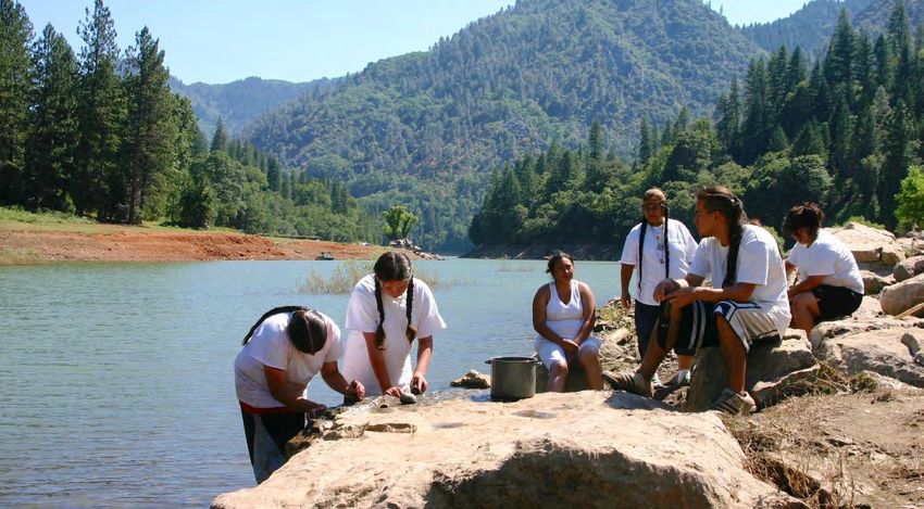
#3
Boundary
Waters
THREAT: Sulfide-ore copper mining

STATE:
Minnesota

                                             PHOTO: SAVE THE BOUNDARY WATERS

AT RISK:
Clean water, recreation economy,
                                             THE RIVER
wildlife habitat                             Much of Minnesota’s northeastern “Arrowhead” region, including the Boundary Waters, is
                                             within the 1854 Ceded Territory, where Anishinaabe people (including the Ojibwe or
SUMMARY                                      Chippewa) retain hunting, fishing and gathering rights. Basswood Lake, located in the
                                             Boundary Waters and Quetico Provincial Park along the border with Canada, is an ancestral
The Boundary Waters Canoe Area
Wilderness encompasses 1,200 miles of        homeland of the Lac La Croix First Nation Community and a sacred place for Anishinaabeg.
rivers and streams and more than 1,000       The Kawishiwi (which in the Ojibwe language means, “river of many beavers’ houses”) River
lakes. As the most visited wilderness        is an important canoe route through the heart of the Boundary Waters Canoe Area
area in America, it is a major driver        Wilderness and the Superior National Forest. Its waters flow out of the Wilderness through
of the local economy. However, the           Birch Lake, re-enter the Boundary Waters through Fall and Basswood Lakes, and then flow
Boundary Waters and its clean water          into Ontario’s Quetico Provincial Park and Minnesota’s Voyageurs National Park.
are threatened by proposed sulfide-
ore copper mining on public lands in
                                             The Boundary Waters draws more than 155,000 overnight wilderness visitors annually, and
the headwaters just outside of the           helps power the recreation economy that supports 17,000 jobs in the region and generates
wilderness area’s boundary. Mining           more than $913 million in sales annually. This area provides world-class recreational
and associated acid mine drainage,           experiences for all residents and visitors. People, fish and wildlife — including walleye,
loss of habitat, forest fragmentation,       northern pike, lake trout, smallmouth bass, wolves, lynx, moose, bear, loons, river otters,
invasive species, and air, noise and light   bald eagles and osprey — all benefit from the clean water that the Boundary Waters provides
pollution would devastate this fragile       for drinking, recreating and refuge.
ecosystem and the wilderness area’s
unique values. The Biden administration
must act to protect the Boundary
Waters from mining by issuing a federal
                                             THE THREAT
mineral leasing ban, and Congress must       The Boundary Waters and the Kawishiwi River are threatened by a massive sulfide-ore
pass legislation to forever protect this     copper mine proposed on the banks of the South Kawishiwi River and Birch Lake, through
treasured place.                             which the river flows. There is strong scientific evidence showing that sulfide-ore copper
                                             mining in the watershed would harm the river and the Wilderness. Hydrologists say that
                                             pollution from mining in this area is inevitable. Hardrock mining is the most toxic industry in
                                             America, according to the Environmental Protection Agency. Sulfide-ore copper mine
                                             contamination harms water, aquatic and terrestrial species, forests and soils, and poses a
                                             serious risk to human health.

                                                                                              AmericanRivers.org/EndangeredRivers2021          8
#3
Boundary
Waters
Continued

                                      PHOTO: NATE PTACEK
FOR MORE INFORMATION:
JESSIE THOMAS-BLATE                   Climate change, which is expected to bring more droughts, alternating with more extreme
American Rivers                       rains, would further exacerbate the negative impacts of a mining operation. Drought-induced
(609) 658-4769
                                      low water flows would concentrate pollutants. Subsequent heavy rains could cause floods
jthomas@americanrivers.org
                                      and the overflow of pollutants into groundwater and streams. Stress on aquatic ecosystems
ALEX FALCONER
                                      caused by climate change will add to the degradation caused by the impacts of
Northeastern Minnesotans for          mining. Conversely, an ecologically healthy Boundary Waters is part of the solution for the
Wilderness/Save the Boundary Waters   climate crisis. Its boreal forests provide for carbon sequestration and play a key role in
(612) 419-3423                        adaption and resilience of species.
alex@savetheboundarywaters.org
                                      Studies show that sulfide-ore copper mining along lakes and streams that flow into the
AMANDA JOHN KIMSEY                    Boundary Waters would put at risk not only premier fishing, hunting and other recreation on
The Wilderness Society                Superior National Forest lands, but also the sustainable economy of northeastern Minnesota.
(406) 920-1999                        An independent peer-reviewed economic study by Harvard Professor James Stock
Amanda_JohnKimsey@tws.org             demonstrated that a ban on copper mining in the Boundary Waters watershed would result in
                                      more jobs and more income for the region.
TANIA LOWN-HECHT
Outdoor Alliance                      A broad coalition of local and national conservation organizations, businesses, hunting and
(202) 780-9650                        fishing groups, youth and other allies are working together to achieve permanent protection
tania@outdooralliance.org             for this ecologically important, cherished landscape from the threat posed by sulfide-ore
                                      copper mining. Bands of the Minnesota Chippewa Tribe and one Canadian First Nation have
BRETT MAYER                           also asked the U.S. government to ban sulfide-ore copper mining on federal public lands in
American Canoe Association            the area, which is part of 1854 Ceded Territory.
(540) 907-4460
bmayer@americancanoe.org

                                      WHAT MUST BE DONE
TAKE ACTION:                          The Biden administration should reverse the indefensible decisions made during the Trump
                                      administration that weakened protection for the Boundary Waters and fast-tracked copper
AmericanRivers.org/                   mining. The U.S. Department of Interior should initiate a 20-year federal ban on mining on
BoundaryWaters2021                    federal public lands in the watershed, starting with a two-year pause and robust study on the
                                      risks of mining in this unique and treasured place.
                                      Further, Congress must pass and President Biden must sign Representative Betty McCollum’s
                                      bill to permanently ban hardrock copper mining on Superior National Forest lands in the
                                      Boundary Waters watershed. This bill was passed by the U.S. House Natural Resources
                                      Committee last September and is expected to be reintroduced in the 117th Congress.

                                                                                     AmericanRivers.org/EndangeredRivers2021          9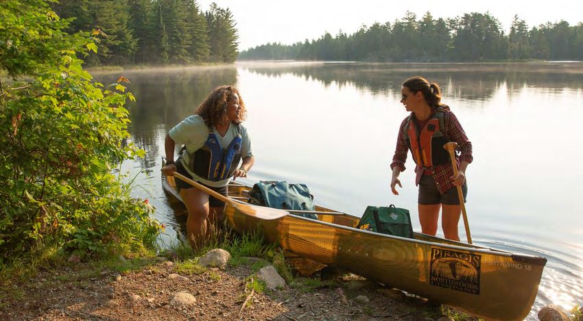
#4
South
River
THREAT: Sewage pollution

STATE:
Georgia

                                             PHOTO: MARGARET SPALDING

AT RISK:
Public health
                                             THE RIVER
                                             Flowing through the ancestral lands of the Muscogee (Creek) Nation from just north of
SUMMARY                                      Hartsfield Jackson International Airport through Arabia Mountain National Heritage Area
                                             (AMNHA) into Jackson Lake, the South River has struggled for decades with extreme
Originating from creeks and streams
                                             environmental impacts concentrated in the two most densely populated areas in
in Atlanta, the South River has
been plagued by sewage pollution             metropolitan Atlanta– the City of Atlanta and DeKalb County. Neither has been particularly
for decades. This pollution has              kind to the river that meanders through primarily moderate to low-income Black
choked the river and impacted the            neighborhoods. Lax regulation and management have contributed mightily to the river’s
health and quality of life in nearby         pollution problems from sanitary and combined sewage and stormwater runoff. Currently,
communities, perpetuating longstanding       both municipalities are under federal consent decrees for Clean Water Act (CWA) violations.
environmental injustice. DeKalb County
                                             Outside of the city, the river’s troubles are masked by the beauty of its surrounding
missed the 2020 deadline set by the
Environmental Protection Agency to fix
                                             landscape. Massive granite outcroppings, cascading waters and a white sand beach frame
the sewer system. Now, the Department        the Panola Shoals Trailhead — the recreational gateway to the South River in DeKalb County.
of Justice and Environmental                 Extending 40 miles to the Southeast along this navigable stretch, the river’s ecosystem and
Protection Agency must examine               wildlife habitat are beautiful and intact. Seven thousand acres of protected greenspace
the circumstances surrounding this           (the combined acreage of AMNHA, Panola Mountain State Park and Monastery of the Holy
failure and the years of lax regulatory      Spirit – a Trappist monks’ sanctuary) make the river an idyllic place for viewing a wide
enforcement. It is critical for the health   variety of birds and an abundance of other wildlife.
of South River communities and the
river that they take immediate action to     Over the last decade, the South River has become an important source of water recreation
ensure that the river and all impacted       where none previously existed. Only 20 minutes from downtown Atlanta, the river attracts
communities are afforded all clean           canoeists and kayakers from throughout the metro area. A new 6.5-mile section of water trail
water protections required by law.           will soon be officially designated just downstream in Rockdale County. Hosting hundreds of
                                             thousands of visitors each year, the AMNHA is a natural locale for expanding the organized
                                             paddle events offered by South River Watershed Alliance that take place throughout late
                                             spring and summer, leading the community to share in the state’s $11.3 billion paddling
                                             sports industry.

                                                                                            AmericanRivers.org/EndangeredRivers2021        10
#4 THE THREAT
DeKalb County owns and operates a sewer system designed to
South collect and transmit wastewater to treatment facilities before being
discharged into the South River in compliance with National
Pollutant Discharge Elimination System (NPDES) permit effluent
River
limitations. The county’s failure to maintain and upgrade its system
has caused sewage to repeatedly overflow from pipes and spill into
waterways before reaching treatment facilities.
In 2010, the Environmental Protection Agency, Georgia
Environmental Protection Division and DeKalb County entered into a
Continued consent decree aimed at bringing the county into compliance with
the Clean Water Act and eliminating sewage spills. The EPA is
responsible for ensuring that the negotiated objectives of the consent
decree are achieved. However, while EPA’s consent decree imposed
a deadline to repair the county’s sewer system in “priority areas”
(June 2020 — already missed), they did not impose a deadline to
address issues in “non-priority areas” (a de-facto statement that
compliance with the Clean Water Act is not necessary in these
FOR MORE INFORMATION: PHOTO: MELANIE COURT
areas). These non-priority areas make up more than two-thirds of
the sewer system with over 1,800 miles of sewer pipes, including the entire navigable length
BEN EMANUEL
of the South River in DeKalb County and the largest concentration of Black residents in the
American Rivers
state. Not surprisingly, most of the sewage spilled from the sewer system is in non-priority
(706) 340-8868
bemanuel@americanrivers.org areas.
The EPA has negotiated an extension of the consent decree deadline or modified consent
JACQUELINE ECHOLS, PHD decree (MCD) with DeKalb County, given that they have not even fully addressed the sewage
South River Watershed Alliance
problem in “priority areas”. The MCD is now focusing on 103 priority work projects (i.e.,
(404) 285-3756
repeat spill locations) — 48 in Priority Areas and 55 in Non-Priority Areas. Theoretically, all
jechols@southriverga.org
projects are to be completed within the next seven years, with most work completed by 2025.
RICKY LEROUX Even if all 55 work projects slated for non-priority areas are completed within the seven-year
Sierra Club Georgia Chapter timeframe, which is very unlikely, the requirement to eliminate all spills by an agreed upon
(404) 607-1262, X234 deadline as required by the Clean Water Act remains far beyond reach.
ricky.leroux@sierraclub.org
FLETCHER SAMS WHAT MUST BE DONE
Altamaha Riverkeeper
(404) 985-9606 It is the responsibility of the EPA to effectively negotiate and enforce consent actions that
fletcher@altamahariverkeeper.org achieve the goals of the Clean Water Act for all, regardless of race, socio-economic status or
geography. Compliance and enforcement are paramount. Neither the consent decree nor
MCD include a deadline to repair the sewer system in “non-priority areas,” thus there is no
requirement for compliance with the Clean Water Act for these impacted communities.
TAKE ACTION: DeKalb County must commit to making the necessary investments to address wastewater
management issues fully and eliminate sanitary sewage spills for all impacted communities
AmericanRivers.org/ in a timely manner. The EPA and the Department of Justice (DOJ) must determine what went
SouthRiver2021 wrong with the negotiation and implementation of the consent decree and take all necessary
actions to restore Clean Water Act protections to the South River and the entire impacted
community. Further, the DOJ should retrospectively review the 2010 consent decree to
determine the foundation and justification for the two-thirds exclusion and identify and
implement actions to remedy this miscarriage of environmental justice — including revising
the MCD to ensure compliance with the Clean Water Act.
Finally, the EPA should exercise its regulatory authority that prohibits intentional
discrimination and unintended discriminatory effects, and actively explore opportunities
through the National Environment Policy Act and the Civil Rights Act, to further bolster
actions to achieve compliance with the Clean Water Act for South River impacted
communities. It is the law, and equal protection is a right that must be upheld for both
water and communities.
AmericanRivers.org/EndangeredRivers2021 11#5
Pecos
River
THREAT: Hardrock mining
STATE:
New Mexico
AT RISK: PHOTO: AMIGOS BRAVOS / JIM O’DONNELL
Clean water, cultural values, habitat
degradation, wildlife, recreation
economy THE RIVER
From its headwaters in northern New Mexico, the Pecos River flows for 926 miles to Texas’s
SUMMARY
Rio Grande. The entire watershed is replete with sacred sites still visited by Pecos, Jemez
The Pecos River and its waters are and Tesuque Pueblo peoples. The name “Pecos” is a Spanish derivative of the Indigenous
considered sacred to the Pecos, Jemez Towa term for the Pecos Pueblo, [p’æyok’ona]. The Pecos was also historically referred to as
and Tesuque Pueblo peoples. With its
the Río Natagés by the Mescalero people of southern New Mexico. Pecos Pueblo was one of
vibrant, millennia-old ties to traditional
the largest trade centers in the West in the 16th and 17th centuries. A landmark of New
Indigenous and historic Spanish
Mexico culture and tradition, today the Pecos watershed is of tremendous value to
communities, the river’s remarkable
cultural history is integrally linked surrounding towns, tribal groups, Spanish acequia, land grant communities, ranchers,
to New Mexico’s identity and future. farmers, anglers, hunters and other outdoor enthusiasts.
A proposed hard rock mine could The Pecos River encompasses a remarkable mosaic of biodiversity. Its headwaters, which
adversely impact over 5,000 acres of begin at an elevation of over 12,000 feet, are a stronghold for New Mexico’s imperiled native
critical subalpine wildlife habitat and the
Rio Grande cutthroat trout. The alpine portion of the upper watershed is home to the nation’s
river’s life-giving clean water. Governor
southernmost populations of ptarmigan. The lower conifer forests are a habitat for both the
Michelle Lujan Grisham has publicly
opposed the mine. The New Mexico
critically endangered Mexican spotted owl and northern goshawk and home to elk, deer,
Mining and Minerals Division must deny black bear, mountain lion and turkey. One of the tributaries potentially impacted by the
the exploratory mining application, the proposed exploration supports struggling patches of the critically endangered Holy Ghost
U.S. Forest Service must adequately ipomopsis — a lovely flowering plant that exists nowhere else in the world and is sacred to
assess the environmental impacts of the the Jemez and Pecos peoples who use it in special spiritual ceremonies. Recognizing the
mining proposal, and Congress must many outstanding values of the Pecos, Congress added more than 40 miles of the river to the
pass legislation to permanently protect National Wild and Scenic Rivers System in 1990.
this special place for communities today
and for generations to come. The Village of Pecos and other small communities within the watershed are home to low-
income Hispanic populations and other historically marginalized groups. These communities
rely heavily on spending from the influx of tourists in the summer and fall coming to enjoy the
Wild and Scenic Pecos River for fishing, camping, hunting and hiking. For centuries, the
Pecos River has been the main source of irrigation water for traditional agricultural practices
which continue to sustain many communities today.
AmericanRivers.org/EndangeredRivers2021 12#5 THE THREAT
Comexico LLC, a Colorado subsidiary of Australian
Pecos mining company New World Resources Ltd., has
acquired 20 federal mining claims for gold, copper
and zinc in the Jones Hill area southwest of Tererro,
River
New Mexico, and surrounding Santa Fe National
Forest lands along the banks of the Pecos River. The
company’s proposed mining project could adversely
impact over 5,000 acres and five of Pecos’
tributaries, plus the Pecos River itself.
Continued Since the 1800s, the Pecos River watershed has
been exploited for valuable metals. From 1927 to
1939, the Tererro Mine and its mill near the Pecos
River were among the most productive lead and zinc
operations in the United States. A community of
Pecos Pueblo people lived in the village of Pecos
from the turn of the 20th century until 1938, when
FOR MORE INFORMATION: PHOTO: CAVU they decided to leave Pecos and move to Jemez
because the river was too poisoned to support their
MIKE FIEBIG livelihoods. A nasty legacy — a massive waste pile — was left behind after the Tererro Mine
American Rivers
closed. That waste contaminated the Pecos River, killed thousands of trout, buried Willow
(406) 600-4061
Creek and led federal environmental officials to recommend the area be declared a
mfiebig@americanrivers.org
Superfund site. Fortunately, the worst of the contaminants from the Tererro Mine were
FRANK “PANCHO” ADELO contained. However, it took several environmental disasters — like heavy snowmelt in 1991
Upper Pecos Watershed that washed pollutants into the river and caused fish kills 11 miles downstream — to make
Association President the cleanup happen. The state spent decades and millions of taxpayer dollars to clean up the
(505) 757.3600 Tererro Mine and the nearby El Molino Mill, where the mined rock was processed.
upwa@pecoswatershed.org
The river ecosystem and the cultures and communities that depend on it cannot afford this
RALPH VIGIL kind of risk again. Hydrologic evidence suggests that this area may also be connected to the
NM Acequia Commission & Local Santa Fe River watershed and aquifer, the City of Santa Fe’s primary drinking water source.
Organic Farmer The surrounding communities have fresh memories from the devastation wrought by past
(505) 603-2879 mining activities. This area is far more precious for its cultural, historical, economic,
molinodelaisla@gmail.com
ecological and recreational values than for the potential short-term earnings that might be
JOSEPH “BROPHY” TOLEDO
derived from destructive mineral mining.
Jemez/Pecos Pueblo
(505) 382-9589
facebroz@gmail.com WHAT MUST BE DONE
GARRETT VENEKLASEN
Comexico hopes to start prospecting for gold, copper and zinc in the Tererro area as soon as
New Mexico Wild it acquires the necessary exploratory permits from the New Mexico Energy, Minerals and
(505) 670-2925 Natural Resources Department (EMNRD) and receives approval from the U.S. Forest Service
garrett@nmwild.org (USFS).
The Stop Tererro Mine Coalition, a formidable coalition of approximately thirty stakeholders,
RACHEL CONN
Amigos Bravos
was formed by local citizens to coordinate a response to the proposed exploratory hard rock
(575) 770-8327 drilling. The coalition is calling on the New Mexico Mining and Minerals Division of EMNRD to
rconn@amigosbravos.org deny the application for an exploratory permit under the New Mexico Mining Act. The U.S.
Forest Service must also take a comprehensive and rigorous look at impacts of the mining
LILIANA CASTILLO proposal, consider a robust range of reasonable alternatives, and allow for inclusive and
Climate Advocates Voces Unidas transparent public participation in the environmental impact evaluation.
(575) 219-9619
liliana@cavu.org Lastly, Senator Martin Heinrich (D-NM) recently introduced the Pecos Watershed Protection
Act (S.4599), which proposes to protect the entire upper Pecos watershed from future mining.
Congress must pass this critical legislation to ensure this special place’s long-term
TAKE ACTION: protection from further degradation from mining.
AmericanRivers.org/
PecosRiver2021
PHOTO: EVAN STAFFORD
AmericanRivers.org/EndangeredRivers2021 13#6
Tar
Creek
THREAT: Toxic water contamination
STATE:
Oklahoma
PHOTO: IAN MAULE
AT RISK:
Clean water, public health
THE RIVER
Tar Creek begins in Kansas and crosses into Oklahoma, flowing through the towns of
SUMMARY Commerce and Miami before joining the Neosho River. The Neosho and Spring Rivers merge
at Twin Bridges State Park, creating the Grand River. Tar Creek and the Grand River feed a
Tar Creek flows through what was
major drinking water source for thousands of Oklahomans — the Grand Lake o’ the
once some of the richest grasslands
of the Southern Plains but is now one Cherokees, created by Pensacola Dam. The watershed is a destination for anglers, hunters,
of the country’s largest Superfund conservationists, artists, recreationists and nature lovers.
sites. Heavy metals from mining have Ottawa County is home to a blended community comprised of nine Indigenous tribes forcibly
contaminated the creek for decades, and moved here during the 19th century and descendants of white settlers. Tribal members make
cleanup efforts continue to fall short,
up more than 20 percent of the population in the county, with many individuals having
threatening the health of Indigenous
ancestry in multiple tribes. The watershed is further shared by the Cherokee Nation, which
communities and other local residents.
The Environmental Protection Agency,
borders it on the West and South.
Federal Energy Regulatory Commission,
State of Oklahoma and tribes must work
together to develop a landscape-scale THE THREAT
solution to clean up the pollution and
After 80 years of working the world’s largest lead and zinc mine, industry abandoned the site
safeguard public health.
in the 1960s, leaving behind 75 million tons of lead-contaminated tailings piles. The Tar
Creek Superfund Site, one of the largest and most complex in the nation, was established by
the Environmental Protection Agency in 1984, becoming one of the first Superfund sites in the
country. The Tar Creek Superfund Site’s epicenter contains forty square miles of abandoned
mines with more than 30 major tailings piles as high as 200 feet tall with lead-contaminated
soils throughout much of the county. For forty years, one million gallons of contaminated
water has discharged daily into Tar Creek, killing most of the Creek’s aquatic life and turning
the water orange due to oxidation. Heavy metal contamination poses a danger from two
directions — upstream at the source from acid mine drainage and surface runoff, and
downstream from the disturbance of contaminated sediments dispersed during floods.
Farms, homes and neighborhoods are put in toxic danger any time a storm causes flooding.
Tar Creek is one of four sites within the Tri-State Mining District of abandoned lead and zinc
mines (spanning Missouri, Kansas and Oklahoma). The mine tailings (essentially waste, often
toxic) were used as gravel for roads, driveways and generally throughout local communities
AmericanRivers.org/EndangeredRivers2021 14#6 without evaluation of, or caution regarding,
the high levels of toxic heavy metals
(specifically lead, cadmium, arsenic and
Tar manganese) in the material or the resulting
irreversible neurocognitive impairments on
humans, especially children. Due to water
Creek
contamination in Tar Creek, residents
cannot safely use or consume fish or plants
in and around Tar Creek. Further, important
Indigenous subsistence lifestyles and
cultural practices, as well as recreational
activities for native and non-native people
Continued alike, are inhibited.
Since its Superfund designation, the EPA
and State of Oklahoma have done piecemeal
work at the site, spending more than $300
million (including buying out towns) — yet
Tar Creek still flows orange, tailings piles
PHOTO: IAN MAULE still loom on the horizon and too many
FOR MORE INFORMATION: children are still poisoned by lead.
JESSIE THOMAS-BLATE As the EPA develops cleanup plans for Tar Creek, it relies on a flawed Conceptual Site Model
American Rivers that ignores groundwater and local riparian and floodplain areas. In doing so, EPA undercuts
(609) 658-4769 the effectiveness of the entire remediation process by consigning the residents of a poor
jthomas@americanrivers.org county to a future in which polluted groundwater and contaminated soils are unavoidable.
This neglect is part of the pattern of behavior at environmental justice sites across the
REBECCA JIM country.
Local Environmental Action Demanded
(LEAD) Agency Concurrently, the Pensacola Dam is going through a hydropower relicensing process with the
(918) 520-6720 Federal Energy Regulatory Commission (FERC). This process is expected to be completed
leadagency@att.net and ready for approval in 2024. Grand River Dam Authority (GRDA), a state agency that
operates the dam and manages the lake, has historically ignored the metals pollution within
ALEXIS HIDALGO
the lake and watershed, in addition to flooding issues. GRDA is asking to raise the lake level
Anthropocene Alliance
an additional two feet in its new license request, thereby increasing the risk to upstream
(305) 781-5147
Alexis@AnthropoceneAlliance.org communities from toxic flood waters and climate change impacts.
BOB NAIRN
Center for Restoration of Ecosystems WHAT MUST BE DONE
and Watersheds
University of Oklahoma Tar Creek is poisoned with regional, watershed-wide pollution that requires a landscape-
(405) 325-3354 level solution. In conjunction with the relicensing of the Pensacola Dam, the EPA, FERC and
nairn@ou.edu State of Oklahoma must collaboratively address historic and ongoing contamination
throughout the Grand Lake watershed. EPA, FERC, the State of Oklahoma, and tribes with
land adjacent to Tar Creek must sign a Memorandum of Understanding (MOU) that requires
TAKE ACTION: all parties to commit to an integrated, landscape-level solution to address both the dam
relicensing and EPA cleanup plans at Tar Creek. In addition, the lake level must not be raised
AmericanRivers.org/ as proposed because doing so will increase the watershed-wide redistribution of sediment-
TarCreek2021 bound heavy metals during floods.
Furthermore, the new EPA Region 6 Administrator must order a new Remedial Investigation
and Human Health Risk Assessment that is more protective of human health and the
environment. The health of communities around Tar Creek can no longer be ignored and set
aside as an accepted casualty of historic mining. Tar Creek must be addressed as a matter of
environmental justice, a priority of the Biden Administration.
Lastly, Congress must reauthorize the Superfund Fee under the Comprehensive
Environmental Response Compensation and Liability Act (CERCLA), which funds cleanup at
Superfund sites across the country. Reauthorizing the Superfund ‘polluter pays’ provision will
provide cleanup money so citizens do not have to pay for cleanup.
AmericanRivers.org/EndangeredRivers2021 15#7
McCloud
River
THREAT: Raising Shasta Dam
STATE:
California
PHOTO: CHRISTOPHER MCLEOD
AT RISK:
Sacred cultural sites and river health
THE RIVER
The McCloud River flows out of the Cascade Range, draining the rugged conifer forests
SUMMARY skirting Mount Shasta. It flows 77 miles to the Pit River, a tributary of the Sacramento River,
and currently ends in Shasta Reservoir. Recognizing its rich fish and wildlife habitat, scenic
The McCloud River, a river protected by
beauty and clean, pristine waters, California protected much of the remaining McCloud River
the state Wild and Scenic Rivers Act, is
one of California’s natural treasures. from dam construction under the state Wild and Scenic Rivers Act in 1989. Several rare and
It was home to the Winnemem Wintu endangered wildlife and plant species are found along the McCloud, including the Shasta
Tribe, who depend on the river for their snow-wreath, Shasta salamanders, McCloud River redband trout and Pacific fisher.
culture, religion and identity. The river’s Since time immemorial, the Winnemem Wintu Tribe has relied on and cared for the river.
health and the Tribe’s cultural values
Fishing and practicing ceremony at sacred sites along the river are central activities to the
are threatened by raising the height of
Tribe’s culture and way of life. The completion of Shasta Dam on the Sacramento River in
Shasta Dam by 18.5 feet, which would
drown vital habitat, riverside lands and
1945 devastated the health and well-being of the McCloud River and Winnemem Wintu Tribe.
numerous sacred sites. To protect the The reservoir — the largest in the state — backed up the waters of the Sacramento River, Pit
river and the Tribe’s way of life, the River and 26 miles of the McCloud River for the joint purposes of long-term water storage,
Biden administration must overturn flood control, hydropower and protection against saltwater intrusion in the San Joaquin/
the Trump administration’s plan to Sacramento River Delta. The eighth-tallest dam in the U.S. at more than 600 feet tall, Shasta
raise the dam. Dam was built without fish passage and had devastating impacts on salmon populations. It
displaced tribal members and flooded ancestral lands, burial grounds and most of the Tribe’s
sacred cultural sites.
THE THREAT
For years, Westlands Water District, the largest irrigation district in the country, has advocated
for raising Shasta Dam to provide more water for big agricultural interests in the Central Valley
Project. There are other solutions to the water needs of agricultural interests, such as updated
reservoir management, improved conservation in agriculture and groundwater banking —
actions that can be implemented without sacrificing more of California’s already greatly
diminished wild rivers.
AmericanRivers.org/EndangeredRivers2021 16#7
McCloud
River
Continued
FOR MORE INFORMATION:
AMY MERRILL
American Rivers
(510) 809-8010
amerrill@americanrivers.org
GARY MULCAHY PHOTO: CAL TROUT
Winnemem Wintu Tribe
(916) 214-8493
In November 2020, the Trump administration, under the direction of Secretary of the Interior
gary@ranchriver.com
David Bernhardt, a former lawyer and lobbyist for Westlands Water District, advanced plans
RON STORK to increase the height of Shasta Dam by 18.5 feet— expanding Shasta Lake by more than 200
Friends of the River billion gallons (or nearly 614,000 acre-feet).
(916) 442-3155 Raising the dam would cause further harm and injustice to sacred sites of the Winnemem
rstork@friendsoftheriver.org
Wintu Tribe, permanently or seasonally flooding approximately 39 sacred sites along the
McCloud River. The project would severely impact the Tribe’s ability to practice their culture
and religion. In addition, the project would cost taxpayers $2 billion, not to mention
decimating the extraordinary scenic, recreational, fish and wildlife values of the state-scenic
TAKE ACTION: McCloud River, flooding more than 5,000 acres of forest and riverside habitat, harming the
river’s wild trout fishery and the salmon that now have to spawn downstream of the dam.
AmericanRivers.org/ Raising the dam could also increase the risk of loss of life in the event of dam failure in a
McCloudRiver2021 seismically active region.
Furthermore, increasing the height of Shasta Dam and expanding the size of Shasta Lake is
illegal under California law. In 1989, the California Legislature amended the California Wild
and Scenic Rivers Act to protect the McCloud River from a dam raise. Raising Shasta Dam
would override California state law and set a dangerous legal precedent for other protected
rivers. A state court has ruled that this law also prohibits any California water agency from
paying for studies or contraction costs for the dam raise.
WHAT MUST BE DONE
Newly appointed U.S. Department of Interior Secretary Deb Haaland has an opportunity to do
the right thing and stop this harmful project. Under the direction of Secretary Haaland,
Department of Interior staff must complete a swift review of the proposed Shasta Dam raise,
fully consider and expose its injustice and illegality, and issue a public determination that the
project is infeasible (in part because it is illegal in California under the California Wild and
Scenic Rivers Act). The Secretary must then kill the project for good by publishing a Record of
Decision that rejects the dam-raise alternatives.
AmericanRivers.org/EndangeredRivers2021 17#8
Ipswich
River
THREAT: Excessive water withdrawals
STATE:
Massachusetts
PHOTO: DEAN BAUMEISTER
AT RISK:
Community resiliency, drinking water, THE RIVER
wildlife habitat, recreation Winding 45 miles from Burlington, Massachusetts, to Plum Island Sound, the Ipswich River is
the main source of drinking water for 350,000 people and businesses in 14 communities.
SUMMARY Located just north of Boston, the basin supports a multi-million-dollar shellfish industry and
The Ipswich River is the main drinking
habitat for several rare and threatened species. Aside from providing clean water and healthy
water source for Northeastern habitat, the Ipswich River offers free, undisturbed nature and recreation for residents of
Massachusetts, but excessive water Essex County, the third-most diverse county in Massachusetts.
withdrawals made worse by climate The Ipswich River feeds into the Great Marsh Area of Critical Environmental Concern, New
change are putting both the ecosystem
England’s largest salt marsh. The marsh includes a National Wildlife Refuge and is an
and the region’s water security at risk.
internationally recognized Important Bird Area. Nearly half the basin is protected by state
Two severe droughts in the
parks, Mass Audubon’s Ipswich River Wildlife Sanctuary, and private and town-owned
last five years and a global climate
crisis have increased the urgency to conservation lands. The Ipswich offers hundreds of miles of trails and other chances to
drastically improve river management. explore nature for five million people within an hour’s drive.
The Massachusetts Department of The Ipswich River (called Agawam in the Algonquian language, meaning ‘beyond the marsh’)
Environmental Protection must fix how flows through ancestral lands of the Pawtucket Tribe, as well as the Massachusett,
it implements existing laws and
Penacook, Pentucket, Abenaki and Wabanaki Confederacy.
improve its regulations to support the
river’s health, regional water security
and the many communities,
businesses and residents who depend THE THREAT
on the Ipswich River.
The greatest threat to the Ipswich River is excessive water withdrawals. The 1986
Massachusetts Water Management Act (WMA) authorizes the Massachusetts Department of
Environmental Protection (DEP) to set water withdrawal limits that factor in environmental
impacts. However, DEP’s implementation of this law follows a confusing system that exempts
more users than it regulates. DEP classifies three categories of users. The first class, which
includes several large water suppliers, were granted automatic water registrations and are
exempt from conservation rules. The second class, any water users withdrawing less than
100,000 gallons per day averaged over the entire year, are also exempt. Since lawn watering
and other outdoor nonessential uses peak when stream flows are lowest in the summer and
early fall, annual averages do not address actual impacts. As droughts are increasing with
AmericanRivers.org/EndangeredRivers2021 18#8 climate change, basing
regulation on annual
averages is ill-advised. In the
Ipswich summer, 15 million gallons
per day are wasted in the
Ipswich due to outdoor
River
watering, even during
drought. Only a third class of
users, those above-threshold
users without registrations,
must obtain permits and
comply with water use and
Continued conservation regulations.
Communities in this third
class grapple with an unfair
system, creating conflict
among residents subject to
different rules while
impacting the same river.
PHOTO: IPSWICH RIVER WATERSHED ASSOCIATION
FOR MORE INFORMATION: The Ipswich River is the
poster child for the state’s outdated water system. An astounding 80 percent of Ipswich water
SHANYN VIARS
American Rivers
is exported out of the watershed. Worse, more than 90 percent of withdrawals are exempt
(607)-426-8283 from any water use conditions like conservation measures. Even in non-drought years,
sviars@americanrivers.org stretches of river run dry. Dry riverbeds result in fish kills, ecological damage, loss of
recreation and threats to the quality and security of the water supply. The climate crisis has
PATRICK LYNCH made things worse. Municipalities and residents are increasingly worried about running out
Ipswich River Watershed Association of water. While behavior and land use changes can lower some water use, we cannot solve
(978) 412-8200 this problem without a more balanced regulatory framework. This is a critical moment for
plynch@ipswichriver.org
state officials, water suppliers, communities and residents to work together to make
Massachusetts a leader for smart water use in an era of climate change.
AMY WEIDENSAUL
Mass Audubon
(978) 887-9264 x7701
aweidensaul@massaudubon.org WHAT MUST BE DONE
2021 is a pivotal year for improving water security in Massachusetts. Both registrations and
JULIA BLATT
Massachusetts Rivers Alliance permits are up for renewal for the first time in two decades. Two severe droughts in the last
(617) 714-4272 five years have spurred leaders into action. A new Drought Bill was introduced in the state
juliablatt@massriversalliance.org legislature to regulate all water use during drought. Massachusetts recently adopted a new
Drought Plan and is now creating several new climate policies. An Ipswich River Task Force
was also formed by local legislators to help facilitate improvements. This is a once-in-a-
TAKE ACTION: generation opportunity to get better rules on the books. New rules will reduce conflict and
spur collaboration between towns. The battle lines are already being drawn — pitting
AmericanRivers.org/ concerned communities, businesses and residents against a faction of water users who
IpswichRiver2021 benefit from the status quo. State legislators and agency officials need to hear from the
public that they support effective and balanced water management that ensures enough
clean water for communities and the river.
Specifically, DEP must overhaul how they regulate water withdrawals to protect rivers and
account for climate change. After several decades of inaction, DEP has announced new
regulations it will attempt to pass this year before renewing water registrations. Without
significant stakeholder involvement and public input, there is considerable risk these
desperately needed changes will not happen.
Limited water supplies, coupled with longer and more severe droughts across the country,
have brought us to a key moment for reimagining water policy and improving the health of
our communities. What we do for the Ipswich River over the coming years could serve as a
litmus test for improving climate and river policy throughout the country.
AmericanRivers.org/EndangeredRivers2021 19You can also read