Benthos and Plankton of Western Lake Michigan Areas of Concern in Comparison to Non-Areas of Concern for Selected Rivers and Harbors, 2012 and 2014
←
→
Page content transcription
If your browser does not render page correctly, please read the page content below
Prepared in cooperation with the Wisconsin Department of Natural Resources and the
U.S. Environmental Protection Agency, Great Lakes National Program Office

Benthos and Plankton of Western Lake Michigan Areas of
Concern in Comparison to Non-Areas of Concern for Selected
Rivers and Harbors, 2012 and 2014

Scientific Investigations Report 2019–5051

U.S. Department of the Interior
U.S. Geological Survey
Cover. Photograph showing Sheboygan River South Pier (photograph by Amanda Bell, U.S. Geological Survey).
Benthos and Plankton of Western Lake
Michigan Areas of Concern in Comparison
to Non-Areas of Concern for Selected
Rivers and Harbors, 2012 and 2014

By Barbara C. Scudder Eikenberry, Hayley T. Olds, Daniel J. Burns,
Amanda H. Bell, and James L. Carter

Prepared in cooperation with the Wisconsin Department of Natural Resources
and the U.S. Environmental Protection Agency, Great Lakes National Program
Office

Scientific Investigations Report 2019–5051

U.S. Department of the Interior
U.S. Geological Survey
U.S. Department of the Interior
DAVID BERNHARDT, Secretary
U.S. Geological Survey
James F. Reilly II, Director

U.S. Geological Survey, Reston, Virginia: 2019

For more information on the USGS—the Federal source for science about the Earth, its natural and living
resources, natural hazards, and the environment—visit https://www.usgs.gov or call 1–888–ASK–USGS.
For an overview of USGS information products, including maps, imagery, and publications,
visit https://store.usgs.gov.

Any use of trade, firm, or product names is for descriptive purposes only and does not imply endorsement by the
U.S. Government.

Although this information product, for the most part, is in the public domain, it also may contain copyrighted materials
as noted in the text. Permission to reproduce copyrighted items must be secured from the copyright owner.

Suggested citation:
Scudder Eikenberry, B.C., Olds, H.T., Burns, D.J., Bell, A.H., and Carter, J.L., 2019, Benthos and plankton of western
Lake Michigan Areas of Concern in comparison to non-Areas of Concern for selected rivers and harbors, 2012 and
2014: U.S. Geological Survey Scientific Investigations Report 2019–5051, 50 p., https://doi.org/10.3133/sir20195051.

ISSN 2328-0328 (online)
iii

Acknowledgments
This study was done in cooperation with the Wisconsin Department of Natural Resources
(WDNR) and the U.S. Environmental Protection Agency, Great Lakes National Program Office,
with funding from the Great Lakes Restoration Initiative. Cheryl Bougie, Donalea Dinsmore,
Andrew Fayram, Stacy Hron, Laurel Last, Megan O’Shea, Victor Pappas, and others of the
WDNR assisted with study planning and sampling logistics; Cheryl Bougie also assisted with
June 2014 sampling at the Fox River near Allouez subsite and July 2014 sampling at the Oconto
River and Lower Green Bay sites. Dr. Kurt Schmude of the Lake Superior Research Institute at
the University of Wisconsin-Superior identified and enumerated benthos, Paul Garrison and Gina
La Liberte of the WDNR identified and enumerated zooplankton and diatoms in the plankton,
and Dawn Perkins of the Wisconsin State Laboratory of Hygiene identified and enumerated soft
algae in the plankton. We also acknowledge Brian Weigel (WDNR) and Jeffrey Dimick (Univer-
sity of Wisconsin-Stevens Point, Aquatic Biomonitoring Laboratory) for sharing their 2003 and
2005 Hester-Dendy sampler data and, together with Jason Knutson and James Hudson of the
WDNR, for assistance with Index of Biotic Integrity calculations.

Kassidy T. Mapel, U.S. Geological Survey (USGS), assisted with all sampling in 2014; Nicolas
Buer (USGS) assisted with Hester-Dendy sampler deployment in 2012. Michelle A. Nott and
James L. Kennedy (USGS) assisted with geographic information systems and the creation of the
map in figure 1; Leah Kammel (USGS) assisted with the finalization of figure 1. Scott A. Grotheer
(USGS), Daniel J. Sullivan (USGS), and two anonymous reviewers provided technical comments
on an earlier version of the report.
iv

     Contents
     Acknowledgments.........................................................................................................................................iii
     Abstract............................................................................................................................................................1
     Introduction.....................................................................................................................................................2
     Methods...........................................................................................................................................................3
          Sample Collection and Processing.....................................................................................................3
          Data Analyses........................................................................................................................................6
     Chemical and Physical Comparisons between Areas of Concern
            and Non-Area of Concern Sites......................................................................................................7
     Condition of the Benthos and Plankton of Areas of Concern
            in Comparison to Non-Areas of Concern for Selected Rivers and Harbors..........................7
          Benthic Assemblage Comparisons between Areas of Concern
                     and Non-Areas of Concern.....................................................................................................8
                Lower Menominee River Area of Concern...............................................................................9
                Lower Green Bay and Fox River Area of Concern................................................................17
                Sheboygan River Area of Concern..........................................................................................19
                Milwaukee Estuary Area of Concern......................................................................................21
          Planktonic Assemblage Comparisons between Areas of Concern
                     and Non-Areas of Concern...................................................................................................22
                Lower Menominee River Area of Concern.............................................................................28
                Lower Green Bay and Fox River Area of Concern................................................................28
                Sheboygan River Area of Concern..........................................................................................35
                Milwaukee Estuary Area of Concern......................................................................................35
          Overview of Benthos and Plankton in Lower Green Bay and Milwaukee Harbor....................37
                Lower Green Bay........................................................................................................................37
                Milwaukee Harbor......................................................................................................................40
     Comparison to Historical Data....................................................................................................................40
          Benthic Assemblage Comparisons to Other Studies.....................................................................40
          Planktonic Assemblage Comparisons to Other Studies................................................................42
     Summary and Conclusions..........................................................................................................................43
          Lower Menominee River AOC site (MENI)......................................................................................43
                Benthos........................................................................................................................................43
                Plankton........................................................................................................................................43
          Lower Green Bay and Fox River AOC—Fox River near Allouez subsite (FOXR).......................44
                Benthos........................................................................................................................................44
                Plankton........................................................................................................................................44
          Sheboygan River AOC site (SHEB)....................................................................................................44
                Benthos........................................................................................................................................44
                Plankton........................................................................................................................................44
          Milwaukee Estuary AOC—Milwaukee River subsite (MILR)
                     and Menomonee River subsite (MENO).............................................................................45
                Benthos........................................................................................................................................45
                Plankton........................................................................................................................................45
     References.....................................................................................................................................................46
v
Figures
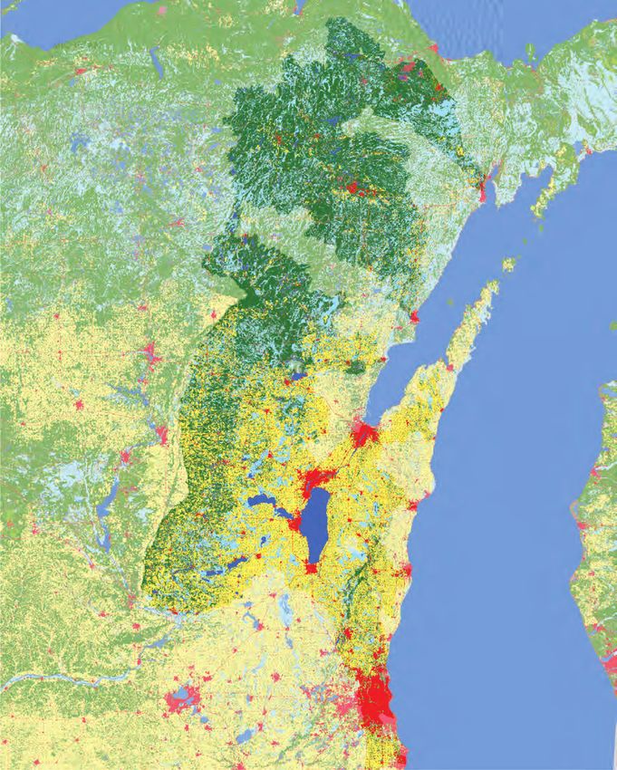
1. Map showing sampling sites and subsites investigated for the evaluation of
benthic and planktonic assemblages at Wisconsin’s 4 Lake Michigan Areas of
Concern and 6 non-Area of Concern comparison sites in Wisconsin and Michigan........4
2. Graphs showing metric values for benthos from 4 Lake Michigan Areas of Concern
and 6 non-Area of Concern comparison sites........................................................................15
2. Graphs showing metric values for benthos from 4 Lake Michigan Areas of Concern
and 6 non-Area of Concern comparison sites........................................................................16
3. Multidimensional scaling ordination plots for combined benthos at 4 Lake Michigan
Areas of Concern and 6 non-Area of Concern comparison sites, based on relative
abundance with no rare or ambiguous taxa...........................................................................20
4. Graphs showing metrics for zooplankton at 4 Lake Michigan Areas of Concern and
6 non-Area of Concern comparison sites................................................................................29
5. Multidimensional scaling ordination plots for zooplankton at 4 Lake Michigan
Areas of Concern and 6 non-Area of Concern comparison sites, with no rare or
ambiguous taxa............................................................................................................................31
6. Graphs showing metrics for combined phytoplankton at 4 Lake Michigan Areas of
Concern and 6 non-Area of Concern comparison sites........................................................32
7. Multidimensional scaling ordination plots for combined phytoplankton at 4 Lake
Michigan Areas of Concern and 6 non-Area of Concern comparison sites, based on
relative abundance with no rare or ambiguous taxa.............................................................34
8. Multidimensional scaling ordination plots for the benthos collected by dredge at
the Green Bay and Lower Fox River Area of Concern, based on relative abundance
with no rare or ambiguous taxa................................................................................................39vi
Tables
1. U.S. Geological Survey sampling locations at Wisconsin’s Lake Michigan Areas of
Concern and non-Area of Concern comparison sites in Wisconsin and Michigan,
including site or subsite number, latitude, longitude, and drainage area............................5
2. Mean and standard deviation for water-quality measurements made in situ with a
Yellow Springs Instrument sonde at about a 1-meter depth in 2012 and 2014 at
Areas of Concern and non-Area of Concern comparison sites in Wisconsin and
Michigan.........................................................................................................................................8
3. Mean and standard deviation for chlorophyll-a, total suspended solids, and volatile
suspended solids for composited water samples collected in 2012 and 2014 at
Areas of Concern and non-Area of Concern comparison sites in Wisconsin and
Michigan.........................................................................................................................................9
4. Mean and standard deviation for sediment size fractions and volatile-on-ignition
solids in bottom sediment collected in 2012 and 2014 at Areas of Concern and
non-Area of Concern comparison sites in Wisconsin and Michigan.................................10
5. Metric means and standard deviations for benthos sampled in 2012 and 2014 at
4 Lake Michigan Areas of Concern in Wisconsin and 6 non-Area of Concern
comparison sites in Wisconsin and Michigan........................................................................11
6. Probability values for significance in paired t-tests comparing metrics for benthos
at Areas of Concern (AOCs) with the mean of all non-AOCs or the mean of the two
non-AOC comparison sites........................................................................................................18
7. Metric means and standard deviations for plankton sampled in 2012 and 2014 at
4 Lake Michigan Areas of Concern in Wisconsin and 6 non-Area of Concern
comparison sites in Wisconsin and Michigan........................................................................23
8. Probability values for significance in paired t-tests comparing metrics for
zooplankton at Areas of Concern (AOCs) with the mean of all non-AOCs or the
mean of the two non-AOC comparison sites..........................................................................30
9. Probability values for significance in paired t-tests comparing metrics for
combined phytoplankton (soft algae and diatoms combined) at each Area of
Concern (AOC) with the mean of all non-AOCs or the mean of the two non-AOC
comparison sites..........................................................................................................................33
10. Summary of metric comparisons for benthos and plankton collected by the
U.S. Geological Survey at Areas of Concern (AOCs) and non-AOC comparison sites
in 2014, indicating where AOC metrics were significantly lower than non-AOC
metrics...........................................................................................................................................37
11. Richness, diversity, and density values for benthos collected by dredge at Green
Bay subsites in 2014....................................................................................................................38vii
Conversion Factors
International System of Units to U.S. customary units
Multiply By To obtain
Length
micrometer (µm) 0.00003937 inch (in.)
meter (m) 3.281 foot (ft.)
meter (m) 1.094 yard (yd.)
kilometer (km) 0.6214 mile (mi.)
Area
square kilometer (km ) 2
0.3861 square mile (mi2)
square meter (m ) 2
1.19599 square yard (yd2)
Volume
liter (L) 0.2624 gallon (gal.)
cubic meter (m ) 3
264.2 gallon (gal.)
Mass
kilogram (kg) 2.205 pound (lb.)
Datum
Vertical coordinate information is referenced to the North American Vertical Datum of 1988
(NAVD 88).
Horizontal coordinate information is referenced to the North American Datum of 1983 (NAD 83).
Supplemental Information
Specific conductance is given in microsiemens per centimeter at 25 degrees Celsius (µS/cm at
25 °C).
Concentrations of chemical constituents in water are given in either milligrams per liter
(mg/L) or micrograms per liter (μg/L). The mesh opening size for the plankton net is given in
micrometers (μm).viii
Abbreviations
ANOSIM analysis of similarity
AOC Area of Concern
BUI Beneficial Use Impairment
EPT Ephemeroptera-Plecoptera-Trichoptera
HD Hester-Dendy (artificial substrate sampler)
IBI Index of Biotic Integrity
MDS multidimensional scaling
MMSD Milwaukee Metropolitan Sewerage District
PCBs polychlorinated biphenyl compounds
SIMPER similarity percentage
TSS total suspended solids
USGS U.S. Geological Survey
VOI volatile on ignition
VSS volatile suspended solids
WDNR Wisconsin Department of Natural ResourcesBenthos and Plankton of Western Lake Michigan Areas
of Concern in Comparison to Non-Areas of Concern for
Selected Rivers and Harbors, 2012 and 2014
By Barbara C. Scudder Eikenberry, Hayley T. Olds, Daniel J. Burns, Amanda H. Bell, and James L. Carter
Abstract The U.S. Geological Survey collected benthos, plankton,
sediment, and water three times per year in 2012 and 2014
Since their designation in the 1980s, Areas of Concern between May and August at the AOC and non-AOC com-
(AOCs) around the Great Lakes have been the focus of multi- parison sites. Except for Lower Green Bay and Milwaukee
State and international cleanup efforts that were needed after Harbor, each AOC site or subsite was paired with sites in two
decades of human activity resulted in severely contaminated non-AOCs with similar environmental conditions. Com-
sediment, water-quality degradation, loss of habitat for aquatic munity-based metrics were compared using univariate and
organisms, and impaired public use. Although individual Great multivariate statistics between each AOC and the mean of all
Lake States had been working to cleanup and mitigate envi- non-AOCs and between each AOC and the mean of two non-
ronmental concerns, there was insufficient funding and little AOC comparison sites. Although it was assumed that, because
coordination between Federal and State efforts to address the of their designation as AOCs, the relationships would indicate
large and complex set of problems. The Great Lakes Ecosys- degraded conditions compared to the non-AOC sites, several
tem Protection Act was passed in 2010, providing for compre- metrics for the AOCs did not significantly differ between the
hensive multi-State planning and dedicating Federal funds to AOCs and non-AOCs in 2014. Of all four AOCs examined
accelerate cleanup and improve conditions at the AOCs with for benthos, only the Lower Menominee River AOC differed
a particular focus on 14 beneficial use impairments, such as from its two non-AOC comparison sites; the density and
degradation of benthos and degradation of phytoplankton and richness of taxa in insect orders Ephemeroptera-Plecoptera-
zooplankton populations. Of Wisconsin’s five AOCs, four lie Trichoptera (mayflies, stoneflies, and caddisflies) in combined
adjacent to Lake Michigan: Lower Menominee River, Lower benthos (dredge and artificial substrate samples) were lower
Green Bay and Fox River, Sheboygan River, and Milwaukee at the AOC. For plankton, the assemblages for zooplankton at
Estuary (which includes the Milwaukee River, Menomonee
the Fox River near Allouez (a subsite in the Lower Green Bay
River, Kinnickinnic River, and Milwaukee Harbor). The
AOC) and the Milwaukee River differed from their two non-
Wisconsin Department of Natural Resources has focused
AOC comparison sites; density of zooplankton was lower at
much of the cleanup on removal of contaminated sediment
both AOCs. Metrics for combined benthos and combined phy-
from these AOCs because many beneficial use impairments
were a result of contaminated sediment. However, recent and toplankton (soft algae and diatoms) at the Sheboygan River
quantitative assessments of the status of benthos and plankton AOC did not differ from the two non-AOC comparison sites;
at the AOCs were lacking. Therefore, to inform management however, the diversity of zooplankton in 2014 was lower at the
decisions regarding the status of benthos and plankton at Sheboygan River AOC than at the two non-AOC comparison
AOCs, the U.S. Geological Survey, in cooperation with the sites. The combination of univariate and multivariate statistics
Wisconsin Department of Natural Resources (WDNR) and the provided a way to evaluate the status of the aquatic assem-
U.S. Environmental Protection Agency, Great Lakes National blage at each AOC and whether or not the assemblage differed
Program Office, assessed the condition of benthos (benthic from less-degraded non-AOC comparison sites. Results for
invertebrates) and plankton (zooplankton and phytoplankton) this study provide multiple lines of evidence for evaluating the
at sites in the 4 AOCs and at 6 less-degraded comparison sites status of aquatic communities at AOC sites in Wisconsin along
(hereafter referred to as “non-AOCs”). the western Lake Michigan shoreline in 2012 and 2014.2 Benthos and Plankton of Western Lake Michigan Areas of Concern in Comparison to Non-Areas of Concern
Introduction webs, benthos and zooplankton are important food sources for
fish, aquatic birds, and other animals. As primary producers,
Aquatic biological communities have been used for more phytoplankton play a major role at the base of aquatic food
than a century as sentinels and endpoints for quantifying the webs in large rivers and lakes, and assemblages are usu-
degree of water and sediment quality degradation as well as ally dominated by diatoms. The percentage of diatoms tends
improvement after remediation. However, recent ecologi- to decrease with pollution, and changes in the assemblage
cal assessments are few in river mouths and harbors of the from dominance by diatoms to dominance by green algae or
Great Lakes, especially along the shoreline of Lake Michigan cyanobacteria (also known as “blue-green algae”) can have a
(Canfield and others, 1996; Scudder Eikenberry and others, cascading effect on secondary consumers (Flotemersch and
2016a). Benthic invertebrates (organisms living near, on, or in others, 2006; Wisconsin Department of Natural Resources,
the bottom of a waterbody, hereafter referred to as “benthos”) 1993).
are considered good indicators of water quality and especially In the 1987 Amendment to the Great Lakes Water Qual-
good indicators of sediment quality because they have direct ity Agreement, the United States and Canada designated
contact with the sediment, are mostly sedentary compared to 43 Areas of Concern (AOCs). Of Wisconsin’s five AOCs, four
fish, and are constantly exposed to any chemical contaminants, lie adjacent to Lake Michigan (International Joint Commis-
low dissolved oxygen, high ammonia, and poor substrate sion United States and Canada, 1987) and include the Lower
conditions. In general, much less is known about the benthos Menominee River, the Lower Green Bay and Fox River, the
of nonwadeable freshwater rivers, river mouths, and harbors Sheboygan River, and the Milwaukee Estuary (which includes
than about wadeable riverine environments (Flotemersch and
the Milwaukee River, Menomonee River, Kinnickinnic River,
others, 2006; Larson and others, 2013; Weigel and Dimick,
and Milwaukee Harbor). AOCs are severely degraded areas
2011; Wells and Demos, 1979). Zooplankton and phytoplank-
that fail to meet quality objectives of the Agreement because
ton (hereafter referred to as “plankton,” mostly microscopic
of the presence of at least 1 of 14 beneficial use impairments
organisms living in the water column) are important food
sources for many organisms and are useful indicators of water (BUIs), including BUIs for the degradation of benthos and the
quality. Together, benthos and plankton can provide a more degradation of phytoplankton and zooplankton populations.
complete assessment of conditions and effectiveness of reme- Historical and ongoing anthropogenic activities contribute
diation at Great Lakes river mouths and harbors than either to degraded sediment, benthos, and plankton at many AOCs.
benthos or plankton can alone. Removal or remediation of contaminated sediment has played
With the long period of human effects on ecosystems in a key role in Great Lakes Restoration Initiative efforts at
Great Lakes river mouths and harbors, characterization of the AOCs. Recent data are lacking to assess whether or not the
taxa or abundances of aquatic organisms that should compose benthos and plankton have recovered.
an unimpaired benthic or planktonic assemblage is a chal- In 2012 and 2014, the U.S. Geological Survey (USGS),
lenge. Also, the hydrodynamic effect of the large lakes can in cooperation with the Wisconsin Department of Natural
be significant because of their proximity as well as the effect Resources (WDNR) and the U.S. Environmental Protection
of seiche and tidal action that can periodically transport lake Agency, Great Lakes National Program Office, completed
water and organisms upriver for varying distances. Neverthe- a study of the benthos and plankton at 10 sites in rivers and
less, the primary effect is from the river and the benthos and harbors along the western Lake Michigan shoreline. A total of
plankton in the river mouth, and harbor samples should reflect 4 sampling sites (plus subsites) were in AOCs and 6 sites were
this dynamic. in less-degraded sites (hereafter referred to as “non-AOCs”).
Relatively diverse fauna with at least modest abundances The purpose of this study is to collect and evaluate data for
of various taxa in a healthy, downstream assemblage would determining whether or not the assemblages of benthos or
be expected in a temperate river mouth or harbor (Larson and
plankton at four Wisconsin AOCs differ from the assemblages
others, 2013). A study of benthos at 50 nearshore reference
at presumptively less-degraded sites with comparable physical
sites in lakes Superior, Huron, Erie, and Ontario by Bailey
and chemical characteristics. This report presents an assess-
and others (1995) found that the 4 most abundant taxa were
ment of the status of assemblage structure of the benthos and
midges, oligochaetes, bivalves, and sponges; however, that
study found considerable variation in benthos across sites plankton at the 4 AOC sites and 6 non-AOC comparison sites
and indicated that there was not a single, well-defined healthy in 2014. The 2014 results are then compared to the results of
ecosystem. The benthos of soft bottom sediment is usually the 2012 study (Scudder Eikenberry and others, 2016a), as
dominated by worms (oligochaetes) and midges (chirono- well as to results for the AOCs from selected historical stud-
mids), with some bivalves and occasional crustaceans, and ies that used similar sampling methods, to provide context
less so water mites, flatworms, and various insect larvae, and and evaluate potential progress in site remediation benefits
the number of taxa usually decreases with depth (Wiederholm, in the four AOCs. State governments, citizen groups, and the
1980). For plankton, the zooplankton is usually dominated by U.S. Environmental Protection Agency can use the results of
rotifers and microcrustaceans, such as cladocerans and cope- this study in making their BUI status determinations and as
pods, and protozoans. As secondary producers in aquatic food baseline information for future studies.Methods 3
Methods historical mean annual discharges at nearby streamgages. For
this reason, and because remediation was completed at the
A total of 4 AOC sites and 6 non-AOC comparison sites, Sheboygan River in 2013, benthos and plankton were sampled
on the western shore of Lake Michigan, were selected for this again in 2014 at all sites using the same methods. All sites
study (fig. 1, table 1). Although all the river mouths or harbors were nonwadeable, so samples were collected from a boat.
along the western Lake Michigan shoreline are degraded to To quantify heterogeneity or “patchiness” of the organisms at
some degree, the non-AOCs selected for comparison with the sites, primary and replicate samples were collected at SHEB
AOCs have natural physical and chemical characteristics that and its non-AOC comparison site on the Manitowoc River
are as close as possible to those of the AOCs, are presump- (hereafter referred to as “MANI”). Water quality at each site
tively less degraded because they are not designated AOCs, was determined during assemblage sampling by measuring
and are assumed to have biological assemblages similar to pH, specific conductance, and water temperature with a Yel-
those that would be present in the AOCs if it were not for the low Springs Instrument sonde.
specific contamination that was identified during the designa- Samples of the benthos were collected at most sites using
tion and listing of each AOC. That is, in the absence of effect, two methods: (1) a standard Ponar dredge for grab samples of
the less-degraded non-AOCs were assumed to have similar surficial bottom sediment and (2) Hester-Dendy (HD) artificial
substrate samplers. HD samplers were deployed at the Fox
biological potential to the AOCs. The AOC sites sampled were
River near Allouez subsite but were not deployed at the Green
the Lower Menominee River AOC at 1 site (hereafter referred
Bay subsites because of inadequate deployment conditions.
to as “MENI”) and the Lower Green Bay and Fox River AOC
A total of three to four grab samples of surficial sediment
(1 subsite [hereafter referred to as “FOXR”] was sampled
were collected and combined into one composite sample per
at the Fox River near Allouez). A total of 6 subsites were
site (U.S. Environmental Protection Agency, 2010a). A small
sampled in lower Green Bay; only 1 subsite (the Lower Green
amount of sediment (less than 50 grams) from each compos-
Bay subsite, hereafter referred to as “GREE”) was sampled for
ite sample was split between two plastic bags for analysis
benthos and plankton and the other 5 subsites were sampled
of sand-silt-clay fractions and the volatile-on-ignition (VOI)
for benthos only. The Sheboygan River AOC was sampled at
component of the sediment. Large debris and empty shells
1 site (hereafter referred to as “SHEB”). The Milwaukee
in the remaining composite sample were examined for any
Estuary AOC is the largest Wisconsin AOC with respect to
attached invertebrates before being discarded, and the rest of
geographic area, population size, and the complexity of its
the composite sample was washed through a 500-micrometer
drainage system. In the Milwaukee Estuary AOC, samples
(µm) sieve. The retained debris and organisms were collected,
were collected at subsites in the Milwaukee River (1 subsite
and the organisms were identified and counted. A total of
hereafter referred to as “MILR”) and the Menomonee River
four individual HDs were deployed for 6 weeks at each site
(1 subsite hereafter referred to as “MENO”), as well as
during each season (two each anchored to a cinder block). HD
the Milwaukee Harbor (1 subsite hereafter referred to as
samplers were placed in areas with good flow to ensure veloci-
“MILH”), which lies downstream from the confluence of these
ties averaged at least 0.09 meters per second (m/s) as recom-
two rivers and the Kinnickinnic River (not sampled). The
mended (Ohio Environment Protection Agency, 1987). Once
terms “location” or “subsite” in this study are used when more
retrieved, three of the four HD samples were randomly chosen
than one area was sampled within an AOC site. Detailed site
to represent the site and all organisms were scraped off and
information is provided elsewhere (Scudder Eikenberry and
composited into one sample per season per site. Each dredge
others, 2014, 2016b).
and HD sample was stained with rose bengal and preserved
with 10-percent buffered formalin. Benthic invertebrates in
Sample Collection and Processing samples were identified and counted by the Lake Superior
Research Institute at the University of Wisconsin-Superior
Detailed method descriptions are available elsewhere (U.S. Environmental Protection Agency, 2010b). Sediment
(Scudder Eikenberry and others, 2014, 2016b). Briefly, samples were analyzed for sand-silt-clay fractions by the
benthos and plankton were collected during three sampling University of Wisconsin Soil and Plant Analysis Laboratory
events about 6 weeks apart in late May/early June, mid-July, through the Wisconsin State Laboratory of Hygiene, except for
and late August 2014. For simplicity, the three sampling five samples analyzed by the USGS Kentucky Water Science
events are hereafter referred to as the “spring,” “summer,” and Center Sediment Laboratory because of low mass. Sediment
“fall” seasonal samples. Unless otherwise specified, use of the samples were analyzed at the USGS in Middleton, Wis., using
term plankton in this report implies zooplankton and phyto- a VOI combustion method (U.S. Geological Survey, 1989;
plankton. High heat and drought during the summer and fall Wentworth, 1922) to provide an estimate of the organic con-
sampling periods in 2012 resulted in lower stream discharges tent of sediment samples.
at some sampling locations when compared to historical mean Artificial substrates such as the HD samplers measure
discharge. The sites most notably affected were MENI, the short-term (1 month) colonization potential, and therefore, the
Milwaukee Estuary subsite MENO, and ROOT where annual attached invertebrates may not reflect the benthos of the loca-
mean discharges in 2012 were about two-thirds or less of the tion. Regardless, they may provide estimates of the organisms4 Benthos and Plankton of Western Lake Michigan Areas of Concern in Comparison to Non-Areas of Concern
90° 89° 88° 87° 86°
LAKE SUPERIOR
MICHIGAN
MICHIGAN
WISCONSIN
46°
5
1
45°
6
WISCONSIN LAKE MICHIGAN
2 7
8
EXPLANATION
9
National land cover
44°
Water
Urban
3
Barren/shrubland
Forest
Grassland
Agriculture
Wetland
Drainage basin
County boundary
4 Sampling site with identifier
43°
1
Area of Concern
6
Non-Area of Concern
10
Map image is the intellectual property of Esri and is used herein under license. 0 20 40 KILOMETERS
Copyright © 2018 Esri and its licensors. All rights reserved.
National land cover data are from DeLorme, NAVTEQ.
0 20 40 MILES
Figure 1. Sampling sites and subsites investigated for the evaluation of benthic and planktonic assemblages at Wisconsin’s
4 Lake Michigan Areas of Concern and 6 non-Area of Concern comparison sites in Wisconsin and Michigan. Site and subsite
numbers with names are provided in table 1.Methods 5
Table 1. U.S. Geological Survey sampling locations at Wisconsin’s Lake Michigan Areas of Concern and non-Area of Concern
comparison sites in Wisconsin and Michigan, including site or subsite number, latitude, longitude, and drainage area.
[All locations except historical Green Bay sites were also sampled in 2012. Plankton samples in the Lower Green Bay and Fox River Area of Concern
were collected only at subsites GREE (2a) and FOXR (2b). A subsite, or additional sampling location within the geographic area of a site, is indicated by
the addition of an alphabet letter to a site number. km2, square kilometer; NA, not applicable]
Site or Latitude1 Longitude2 Comparison
Abbreviated Drainage3
Site or subsite name subsite (decimal (decimal site or subsite
name area (km2)
number degrees) degrees) number
Areas of Concern
Lower Menominee River MENI 1 45.09810 −87.60772 10,490 5, 6
Lower Green Bay and Fox River NA 2 NA NA NA NA
Lower Green Bay GREE 2a 44.57751 −87.98600 16,584 NA
Green Bay Historical Subsite 3–1 GB03 GB03 44.56611 −87.99158 16,584 NA
Green Bay Historical Subsite 5 GB05 GB05 44.54444 −87.99444 16,584 NA
Green Bay Historical Subsite 8 GB08 GB08 44.54861 −87.94861 16,584 NA
Green Bay Historical Subsite 16 GB16 GB16 44.55972 −87.95972 16,584 NA
Green Bay Historical Subsite 17 GB17 GB17 44.57222 −87.93889 16,584 NA
Fox River near Allouez FOXR 2b 44.49499 −88.02424 16,178 7, 8
Sheboygan River SHEB 3 43.74887 −87.70352 1,043 8, 9
Milwaukee Estuary NA 4 NA NA NA NA
Milwaukee River MILR 4a 43.04789 −87.91269 1,779 9, 10
Menomonee River MENO 4b 43.03220 −87.92156 381 9, 10
Milwaukee Harbor MILH 4c 43.02501 −87.89722 2,193 NA
Non-Area of Concern comparison sites
Escanaba River, Michigan ESCA 5 45.77845 −87.06325 2,393 1
Oconto River OCON 6 44.89198 −87.83678 2,502 1
Ahnapee River AHNA 7 44.60979 −87.43484 274 2b
Kewaunee River KEWA 8 44.46073 −87.50205 354 2b, 3
Manitowoc River MANI 9 44.09190 −87.66183 1,341 3, 4a, 4b
Root River ROOT 10 42.72866 −87.78827 514 4a, 4b
1
Vertical coordinate information is referenced to the North American Vertical Datum of 1988.
2
Horizontal coordinate information is referenced to the North American Datum of 1983.
3
Drainage area determined using Hydrologic Unit Codes as described in Seaber and others, 1987.
associated with firmer (and potentially less contaminated) below the surface to just above the bottom or, if the available
substrate than exists at a site. One advantage of using artificial depth was less than 5 m, samples were repeated at available
substrates in assessments is to minimize the effect of habitat 1-m intervals until five whole-water samples were collected.
differences and allow the comparison of colonization potential Subsamples were collected from the whole-water sample for
on a single consistent substrate across all sites. the identification and counting of “soft” algae phytoplankton
Samples of plankton for each site consisted of a plankton (cyanobacteria or “blue-greens,” cryptomonads, desmids,
net sample to collect larger zooplankton and a set of whole- dinoflagellates, euglenoids, and greens) and diatom phyto-
water samples to collect phytoplankton. Zooplankton were plankton, and analysis of chlorophyll-a, total suspended solids
collected using a 63-µm mesh plankton net towed vertically (TSS), and volatile suspended solids (VSS; U.S. Environ-
from a depth of 5 meters (m) to the surface (U.S. Environ- mental Protection Agency, 2010d). Samples of zooplankton
mental Protection Agency, 2010c). If the available depth was and phytoplankton were preserved with glutaraldehyde to a
less than 5 m, multiple tows were taken from just above the 1-percent final solution. Soft algae were identified and counted
bottom to the surface until a 5-m total depth was sampled. at the Wisconsin State Laboratory of Hygiene (Karner, 2005).
A Kemmerer vertical water sampler was used to collect a set Zooplankton and diatoms were identified and counted at the
of five whole-water samples at 1-m depth intervals from 1 m WDNR (U.S. Environmental Protection Agency, 2010e, f).6 Benthos and Plankton of Western Lake Michigan Areas of Concern in Comparison to Non-Areas of Concern
Analyses of chlorophyll-a, TSS, and VSS were done at the basis. Replicate sample data (SHEB and MANI only) were not
Wisconsin State Laboratory of Hygiene (American Public used in comparisons between AOCs and non-AOCs. Com-
Health Association and others, 2006; Kennedy-Parker, 2011). parisons were begun at a broad level by comparing each AOC
site to all non-AOCs as a group across all seasons using the
means of non-AOCs within a season (n=3). Comparisons were
Data Analyses then narrowed to comparing each AOC site or subsite with
its two non-AOC comparison sites across all seasons, again
Potential differences in assemblages between AOCs
using the means of the two non-AOC comparison sites within
and non-AOCs were first determined within a year and then
season. Comparing each AOC to a matched pair of non-AOCs
between years. Except for the Lower Green Bay and Milwau-
provided a more robust measure of potential difference. If a
kee Harbor subsites, each AOC site and associated subsite
metric value was lower at the AOC than at the non-AOCs,
was matched to two non-AOC sites (hereafter referred to
then the AOC was rated as degraded for that metric. Lack of a
as “non-AOC comparison sites”) based on the similarity
significant difference does not imply that the AOC assemblage
of available environmental data as described earlier in the
is not degraded but that it was not rated as degraded in com-
“Methods” section. Some non-AOCs were used for more than parison to the selected non-AOCs. Sample size for compari-
one AOC in comparisons. Metrics were computed from the sons (n=3), with just 1 value per site for each of the 3 seasons
assemblage data for comparisons between sites and years. The in a year, was low in this study. The lower the sample size or
metrics used for comparisons were total taxon richness (the number of samples, the lower the statistical power and the
total number of taxa), the Shannon diversity index (Shan- lower the ability to detect a true difference between samples
non, 1948), and total abundance (density) for dredge and HD or sites when a difference exits (Gotelli and Ellison, 2004). In
sampler data combined (hereafter referred to as “combined some statistical comparisons, between-site seasonal differ-
benthos”), zooplankton, and soft algae and diatoms combined ences may have led to high variances and contributed to an
(hereafter referred to as “combined phytoplankton”). Addi- inability to detect differences between AOCs and non-AOCs.
tional metrics were computed for the benthos. These metrics Also, values for some metrics differed between non-AOC
included richness, density, and percentage of individuals in comparison sites. High variability is also likely among the
insect orders Ephemeroptera-Plecoptera-Trichoptera (EPT; group of six non-AOCs; however, this metric was not tested.
mayflies, stoneflies, and caddisflies) for combined benthos A total of four PRIMER software (Clarke and Gorley,
and a macroinvertebrate index of biotic integrity (IBI) based 2006) routines were used for multivariate analyses with rela-
on HD sampler data only. The IBI was designed for use with tive abundances of taxa. Relative abundance was used because
HD sampler data for large, nonwadeable rivers of Wisconsin of the possibility of uneven effort among samples. The rou-
(Weigel and Dimick, 2011). An IBI is a multimetric that com- tines used were (1) DIVERSE—to calculate diversity in loge;
bines structural metrics (for example, richness, diversity, and (2) similarity percentage (SIMPER)—to assess differences
relative abundance), functional metrics (for example, feeding in the relative abundances of taxa between each AOC and its
groups), and tolerance metrics (for example, percentage of non-AOC comparison sites, among primary and replicate sam-
tolerant taxa) to generate a numeric value that indicates the ples collected each season at SHEB and MANI, and among
assemblage condition. The combination of structural and func- subsites within the Lower Green Bay and Fox River (benthos
tional metrics can make IBIs more effective than a single met- only) and Milwaukee Estuary AOCs; (3) multidimensional
ric for defining differences or change in assemblages. Indices scaling (MDS), a nonmetric method based on relative abun-
to evaluate the benthos of deep freshwater environments are dances of taxa—to derive assemblage site scores and create
still in development. At present, no IBIs exist for zooplankton ordination plots of sites and (or) samples; and (4) analysis of
or phytoplankton in river mouths or harbors; therefore, seven similarity (ANOSIM)—to compare assemblages among sites
metrics/multimetrics were used when comparing benthos and and samples using similarity matrices in a procedure analo-
three metrics were used when comparing plankton. Means of gous to an analysis of variance.
metric values for non-AOCs were calculated within a sam- For multivariate analyses with PRIMER software, the
pling event (season). relative abundance of each taxon was determined for each
Paired t-tests were used to compare metrics between sample and then fourth-root transformed to allow common
sites. Comparisons were made between AOCs and the mean and rare taxa to affect outcomes (Clarke and Gorley, 2006).
of all non-AOCs and between AOCs and their two matched A Bray-Curtis similarity matrix was calculated between each
non-AOC comparison sites. Some non-AOCs were compared set of samples, and these similarity matrices formed the basis
with more than one AOC. In all, the sample size (n) was 3; of SIMPER and ANOSIM comparisons. A one-way ANO-
unless otherwise stated, use of the term “significant” refers SIM was used to determine the extent to which benthos and
to statistical values of probability (p) less than (Condition of the Benthos and Plankton of Areas of Concern in Comparison to Non-Areas of Concern 7
comparison with the non-AOC comparison sites. Multivariate water-quality values differed between an AOC and non-AOC
results allow for an evaluation of how similar or different the comparison sites. Values for mean specific conductance at
assemblages at each AOC and its two non-AOC comparison MENI and FOXR in the Green Bay and Fox River AOC were
sites are and aid in understanding differences in metrics. How- lower than at their two respective non-AOC comparison sites,
ever, because we assumed that non-AOCs represent the best and specific conductance was higher at SHEB than at its two
available nondegraded condition, large differences between non-AOC comparison sites. Johnson and others (2015) found
AOC and non-AOC assemblages may indicate that the AOC that values higher than 363 microsiemens per centimeter (µS/
was not meeting expectations. cm) inhibited the growth of mayfly larvae. Although mean
Ambiguous taxa, taxa whose abundances are reported for specific conductances at MENI and one of its non-AOC
multiple and related taxonomic levels, were resolved on a per comparison sites, the Oconto River non-AOC comparison site
sample basis before calculating metrics and before completing (hereafter referred to as “OCON”), were below this value in
multivariate analyses by distributing counts for the parent to 2012 and 2014, the mean specific conductance at the other
the children present within each site, based on the proportion non-AOC comparison site, the Escanaba River, Michigan
of counts already assigned to each child, and removing the (hereafter referred to as “ESCA”), was below this value in
counts for the parent (Cuffney and others, 2007). If no children 2014 only. Mean specific conductances at FOXR and its two
were present in the sample, then counts were left with the non-AOC comparison sites, as well as at SHEB and its two
parent as originally identified. This procedure for dealing with non-AOC comparison sites, were all above 363 µS/cm. Water
ambiguous taxa was applied to the benthos and zooplankton; temperatures in 2014 were higher at MENI, FOXR, SHEB,
there were no ambiguous soft algae in samples of phyto- and MENO in the Milwaukee Estuary AOC when compared to
plankton, so this procedure was used on only diatoms in the their non-AOC comparison sites. Higher water temperatures
phytoplankton. have implications for comparisons of plankton at these AOCs
Richness was computed by totaling the number of and non-AOC comparison sites because temperature is one
unambiguous taxa; diversity was calculated using the Shannon control of growth for plankton.
diversity index (in loge) on raw abundances of taxa without Chlorophyll-a and suspended solids (TSS and VSS) are
data standardization or transformation using all unambiguous indicators of algal biomass (table 3). Nondetections for VSS
taxa. Richness and diversity were calculated separately for data in summer and fall at MENI and MENO precluded test-
the two benthic sampling types—dredge and HDs—as well ing VSS values for these two sites. Paired t-tests indicated that
as for the combined (dredge and HDs) benthic samples. The values for these measurements were not different between any
macroinvertebrate IBI was calculated only for the HD samples AOC and non-AOC comparison sites in 2012 or 2014, and
as described by Weigel and Dimick (2011). The IBI values or there were no differences within each site/subsite between
“scores” range from 0 (worst) to 100 (best) and are rated as 2012 and 2014 with respect to these three parameters. This
follows: very poor (less than or equal to [≤] 19), poor (20–39), result for chlorophyll-a and suspended solids indicates that the
fair (40–59), good (60–79), and excellent (greater than or biomass of phytoplankton did not differ between AOCs and
equal to 80). Richness and diversity were also calculated sepa- non-AOCs during these periods.
rately for soft algae and diatom phytoplankton, as well as for Although each AOC site or subsite except Green Bay
combined phytoplankton (soft algae and diatoms combined). sites and the MILH subsite was paired with two non-AOCs
Relative abundance or dominance of taxonomic groups in the based on similar watershed characteristics, sediment size frac-
phytoplankton was computed from densities in the original tion and organic carbon content (as estimated by VOI) differed
soft algal dataset, which also included the density of diatoms between AOCs and their non-AOC comparison sites (table 4).
as a group. Results for size fraction and organic carbon content are
included with results for benthic communities at each AOC.
Chemical and Physical Comparisons Condition of the Benthos and Plankton
between Areas of Concern and Non- of Areas of Concern in Comparison to
Area of Concern Sites Non-Areas of Concern for Selected
All physical and chemical data are available in Scudder Rivers and Harbors
Eikenberry and others (2014, 2016b). There were no differ-
ences between years within each site/subsite with respect to Differences in benthos and plankton at AOCs were
water temperature, pH, and specific conductance except at evaluated by comparing computed biological metrics as well
the MILH subsite in the Milwaukee Estuary AOC (table 2). as relative abundances of individual taxa comprising the
Specific conductance at MILH was higher in 2014 than in aquatic assemblages at each site. Results for each AOC are
2012, reflecting differences in the type and (or) amount of discussed separately in the following sections to allow the
dissolved major ions in the water. In 2014, one or more reader to focus on the benthos or plankton of a single AOC8 Benthos and Plankton of Western Lake Michigan Areas of Concern in Comparison to Non-Areas of Concern
Table 2. Mean and standard deviation for water-quality measurements made in situ with a Yellow Springs Instrument sonde
at about a 1-meter depth in 2012 and 2014 at Areas of Concern and non-Area of Concern comparison sites in Wisconsin and
Michigan.
[The number of samples is 3 for each mean and standard deviation. °C, degree Celsius; μS/cm at 25 °C, microsiemens per centimeter at 25 °C; ±, plus
or minus; MENI, Lower Menominee River; FOXR, Fox River near Allouez (Lower Green Bay and Fox River subsite); SHEB, Sheboygan River; MILR,
Milwaukee River; MENO, Menomonee River; MILH, Milwaukee Harbor (MILR, MENO, and MILH are Milwaukee Estuary subsites); ESCA, Escanaba
River, Mich.; OCON, Oconto River; AHNA, Ahnapee River; KEWA, Kewaunee River; MANI, Manitowoc River; ROOT, Root River]
2012 2014
Site Specific Specific
Water temperature Water temperature
pH conductance pH conductance
(°C) (°C)
(µS/cm at 25 °C) (µS/cm at 25 °C)
Areas of Concern
MENI 24.1±1.9 7.60±0.16 283±39 22.0±1.5 7.77±0.08 256±34
FOXR 24.4±4.1 8.18±0.71 434±20 23.5±0.6 8.53±0.45 385±9
SHEB 19.8±2.7 8.28±0.23 485±144 21.2±0.7 7.96±0.15 594±53
MILR 22.6±4.4 8.15±0.53 805±171 22.3±0.3 7.88±0.11 656±45
MENO 23.4±2.9 7.47±0.40 621±74 24.1±1.8 7.70±0.08 875±230
MILH 21.1±3.4 7.91±0.43 524±74 21.0±2.4 7.76±0.08 734±70
Non-Area of Concern comparison sites
ESCA 23.1±1.5 7.44±0.10 647±148 20.4±1.1 7.49±0.13 352±72
OCON 23.7±2.5 7.75±0.37 305±28 20.6±1.3 7.76±0.13 328±10
AHNA 17.5±6.1 8.15±0.11 422±109 17.9±1.3 7.72±0.23 584±6
KEWA 20.7±3.8 8.34±0.08 412±42 18.7±1.7 7.97±0.35 498±10
MANI 21.1±2.3 7.95±0.63 544±80 21.3±1.0 7.88±0.28 535±98
ROOT 22.8±1.9 7.94±0.13 800±263 20.6±2.9 8.01±0.39 930±83
of interest, and results for all comparisons are summarized. 35-percent similarity. Because of the low similarity for fall
Because the Green Bay subsites and MILH were not compared diatom samples, similarities for fall combined phytoplankton
to non-AOCs, they are presented in a separate section later in were also low. In 2014, for example, fall diatom densities
this report. Results and data for the 2012 sampling have been in the Sheboygan River primary and replicate samples were
previously published (Scudder Eikenberry and others, 2014, dominated (more than 75 percent) by one colony-forming
2016a), and data for the 2014 sampling are provided in Scud- centric taxon, but overall, there were fewer taxa and higher
der Eikenberry and others (2016b). densities in the replicate sample. Also, fall diatom densities in
Dreissena polymorpha (zebra mussels), an invasive spe- the Manitowoc River primary and replicate samples in 2014
cies in Lake Michigan and many tributaries, were present in were dominated by other colony-forming centric taxa. Using
many samples from the benthos and plankton. Although Dreis- relative abundances for samples of combined phytoplankton
sena in the benthic samples were not identified to species, they in comparisons with AOCs lessened the effect of differences
were likely zebra mussels because all immature Dreissena in the fall diatom taxa. Results of paired t-tests indicated
(“veligers”) in samples of zooplankton were identified as zebra that there were no differences between metrics computed for
primary and replicate samples of benthos, zooplankton, and
mussels. Because of extremely high numbers of zebra mussel
combined phytoplankton for either SHEB or MANI in 2014.
veligers in three samples of zooplankton, counts of this taxon
were estimated at MILR and MILH (more than 2,000 at each)
and ROOT (more than 4,000) in fall 2014. Benthic Assemblage Comparisons between
There was minimal variability among field replicates Areas of Concern and Non-Areas of Concern
within each season for most taxonomic groups. Primary and
replicate samples were collected at two sites, SHEB and its The benthic assemblage that was compared between an
non-AOC comparison site, MANI. Within each site, replicate AOC and non-AOCs was based on the combination of dredge
samples had Bray-Curtis similarities higher than 60 per- and HD samples (hereafter referred to as “combined ben-
cent except for fall diatom samples, which had only a 34- to thos”) to better represent the potential assemblage at each site.Condition of the Benthos and Plankton of Areas of Concern in Comparison to Non-Areas of Concern 9
Table 3. Mean and standard deviation for chlorophyll-a, total suspended solids, and volatile suspended solids for composited
water samples collected in 2012 and 2014 at Areas of Concern and non-Area of Concern comparison sites in Wisconsin and
Michigan.
[The limit of detection for suspended solids is 2 mg/L. The number of samples is 3 for each mean and standard deviation. µg/L, microgram per liter;
mg/L, milligram per liter; MENI, Lower Menominee River; ±, plus or minus; FOXR, Fox River near Allouez (Lower Green Bay and Fox River subsite);
SHEB, Sheboygan River; MILR, Milwaukee River; MENO, Menomonee River; MILH, Milwaukee Harbor (MILR, MENO, and MILH are Milwaukee
Estuary subsites); ESCA, Escanaba River, Mich.; OCON, Oconto River; AHNA, Ahnapee River; KEWA, Kewaunee River; MANI, Manitowoc River;
ROOT, Root River]
2012 2014
Site Total Volatile Total Volatile
Chlorophyll-a Chlorophyll-a
suspended suspended suspended suspended
(µg/L) (µg/L)
solids (mg/L) solids (mg/L) solids (mg/L) solids (mg/L)
Areas of Concern
MENI 3.44±1.65 4.0±1.0 2.67±1.15 4.51±1.82 3.60±1.98 7.67
FOXR 72.4±27.6 45.3±29.4 19.7±13.6 91.9±57.3 46.1±20.9 22.9±10.0
SHEB 44.4±33.3 16.0±8.9 6.67±3.06 15.2±11.9 16.8±9.7 9.17±8.25
MILR 22.6±13.4 17.0±14.0 9.00±9.54 7.26±4.43 20.9±5.9 8.72±5.88
MENO 18.5±18.2 7.67±4.04 4.50±2.12 11.0±3.8 16.2±12.9 17.0
MILH 23.3±22.5 5.0±3.0 3.50±2.12 6.99±4.16 7.55±3.08 6.33±2.83
Non-Area of Concern comparison sites
ESCA 1.37±0.33 4.3±2.1 4.0±0.0 1.70±0.71 4 6.7
OCON 3.72±1.76 3.33±1.15 2.0±0.0 4.06±0.53 4.24±1.17 8.3
AHNA 22.0±16.7 11.7±5.0 7.7±5.1 19.3±5.3 7.78±6.26 11.7±11.8
KEWA 23.3±10.8 12.3±7.5 6.3±2.3 21.7±28.0 41.0±9.9 15.1±0.6
MANI 18.5±10.5 14.0±9.9 7.0±4.6 17.5±22.0 29.3±14.4 9.1±6.8
ROOT 19.9±4.0 20.7±19.4 7.3±4.2 13.9±12.2 33.2±33.5 9.8±8.8
Except for the IBI metric (computed from HD sampler data), polychlorinated biphenyls (PCBs), polycyclic aromatic hydro-
all metrics used in comparisons were for combined benthos carbons (also known as PAHs or coal tars), paint sludge, and
even though metrics were also computed for dredge and HD heavy metals including cadmium, chromium, copper, lead,
sampler data (table 5). Benthic communities collected by mercury, nickel, and zinc (U.S. Environmental Protection
dredge in 2014 were dominated by oligochaetes (68 percent) Agency, 2013a; Wisconsin Department of Natural Resources
and (or) midges (20 percent; chironomids). Of the 68 percent and Michigan Department of Environmental Quality, 2011).
of oligochaetes, most were immature Tubificinae. Benthic Sediment remediation was completed in November 2014 at
assemblages collected by HD samplers in 2014 were domi- the Lower Menominee River AOC and was therefore ongo-
nated by midges (38 percent) and oligochaetes (21 percent). ing upstream when the 2014 samples were collected. The
Statistical comparisons between AOCs and non-AOCs for Escanaba River and Oconto River sites (ESCA and OCON)
combined benthos indicated differences in one or more metric were the two non-AOC sites selected for comparisons to
values for every AOC. Differences in the relative abundance MENI because they have similar climate (cooler temperatures
and distribution of combined benthic taxa at AOCs and and higher snowfall than the more southern AOCs; Albert,
non-AOCs in 2014 are shown in the MDS ordination plots 1995), latitude, and geology. All three are cold-water rivers
(as described in the “Data Analyses” section). More similar (based on maximum daily mean temperatures less than about
samples appear closer together, indicating greater similarity, 20–22 °C with resultant fish assemblages; Lyons and oth-
and less similar samples plot farther apart. ers, 1996; Epstein, 2017) that have relatively high gradients,
mostly sand and gravel (glaciated) surficial deposits, and
Lower Menominee River Area of Concern parts that flow over bedrock. The Oconto River drains more
clay surficial deposits than the other two rivers, mostly in the
The Lower Menominee River was designated an lower reaches (Robertson and Saad, 1995). Land cover/land
AOC because of sediment contamination with arsenic, is primarily forested and used for pulp production, with littleYou can also read