WINTER STEELHEAD SPAWNING SURVEY PROCEDURES MANUAL 2020 - OREGON ADULT SALMONID INVENTORY AND SAMPLING PROJECT (OASIS) OREGON DEPARTMENT OF FISH ...
←
→
Page content transcription
If your browser does not render page correctly, please read the page content below
WINTER STEELHEAD SPAWNING SURVEY
       PROCEDURES MANUAL

                2020

 OREGON ADULT SALMONID INVENTORY AND
       SAMPLING PROJECT (OASIS)
OREGON DEPARTMENT OF FISH AND WILDLIFE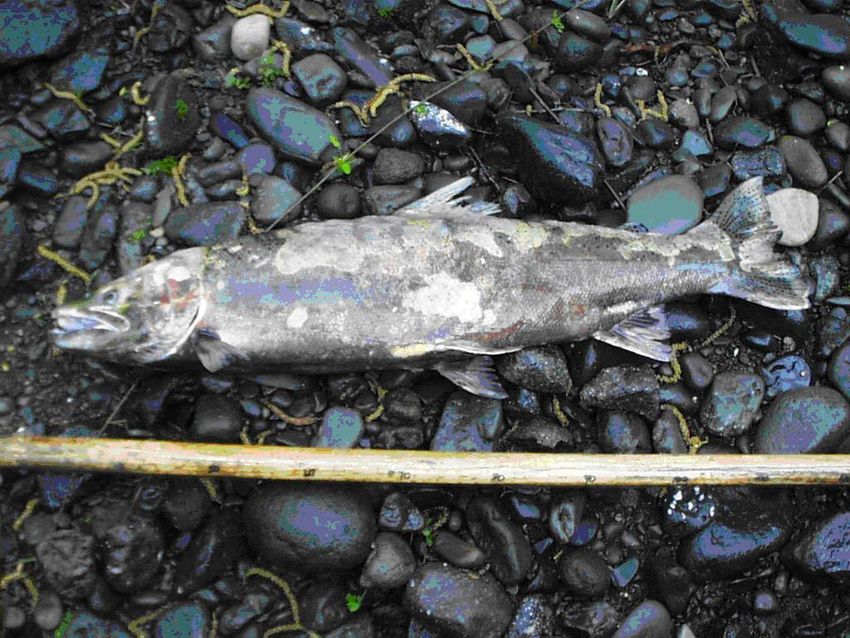
TABLE OF CONTENTS

INTRODUCTION .......................................................................................................................... 2
SURVEYOR SUPPLY LIST .......................................................................................................... 3
SURVEY PROCEDURES ............................................................................................................. 4
   Organizing Work .................................................................................................................... 4
   Survey Considerations ............................................................................................................ 4
   Fish Counts ............................................................................................................................. 5
   Redd Counts and Marking ...................................................................................................... 6
   Steelhead Survey Data Form Codes ....................................................................................... 8
SPAWNING SURVEY EVALUATION FORM ......................................................................... 10
   Spawning Survey Evaluation Form Instructions .................................................................. 11
DESCRIPTION CHANGES ......................................................................................................... 12
LANDOWNER CONTACTS....................................................................................................... 13
STEELHEAD IDENTIFICATION .............................................................................................. 16
   Steelhead Carcass Photos ...................................................................................................... 17
   Redd Photos .......................................................................................................................... 18
   Fin Nomenclature.................................................................................................................. 19
CARCASS SAMPLING ............................................................................................................... 20
PUBLIC RELATIONS AND SAFETY ....................................................................................... 23
BOAT SAFETY AND TECHNIQUES ........................................................................................ 24
   Gear Care and Preparation .................................................................................................... 24
   Common Dangers and Concerns .......................................................................................... 25
   Boating Techniques .............................................................................................................. 27
   What to do if you go for a swim ........................................................................................... 29
SANITIZING SAMPLING GEAR............................................................................................... 29
POLICIES AND PROCEDURES ................................................................................................ 31
   Personnel ............................................................................................................................... 31
   Safety .................................................................................................................................... 32
   State Vehicle ......................................................................................................................... 33
   Report of Operations ............................................................................................................. 35
2020 WINTER STEELHEAD SPAWNING SURVEY AND SITE VERIFICATION STAFF .. 36
PDA APPLICATIONS & PROGRAMS ...................................................................................... 38

SITE LIST.……………………………………………………………………………………….41
INTRODUCTION

Winter steelhead (Oncorhynchus mykiss) historically occurred in varying abundance in all of
Oregon’s coastal streams. In 1992, the harvest of natural origin steelhead was restricted as a
conservation measure by the Oregon Department of Fish and Wildlife (ODFW). Further
restrictions have followed, effectively eliminating the take of natural origin steelhead in much of
coastal Oregon. In the past, a combination of dam passage counts and angler catch card records
were used to track trends in adult steelhead abundance. The elimination or significant reduction
in angler retention of natural origin steelhead significantly reduced the value of using catch-card
data for indexing trends in coastal Oregon natural steelhead populations. Accurately depicting
the status of steelhead populations is imperative for the management of steelhead resources,
leading to the development of this project as a method for tracking abundance, distribution,
timing, and hatchery-wild relationships in wild winter steelhead.

Unlike coastal salmon monitoring, which relies on live adult counts and carcass recoveries to
estimate abundance, steelhead monitoring relies on redd counts and observations of live fish.
This is because steelhead spend only a short time on spawning beds, and fish not actively
spawning are elusive, hard to count and do not usually die near where they spawn. Also, the
winter steelhead spawning season is protracted, lasting up to 6 months. Steelhead also have a
basin wide spawning distribution, spawning in higher gradient headwater streams as well as
larger tributaries and mainstem rivers.

The 2020 survey season will be the eighteenth year of coast wide random steelhead adult
sampling, and the eleventh year in select populations of the Lower Columbia. A spatially
balanced probabilistic sampling design was used to select survey sites across a stream network of
winter steelhead spawning habitat. Repeat visits to each site from February through May will
generate a total redd count for each survey, which will then be used to generate abundance
estimates. Sites must be visited at least once every fourteen days. Survey effort in the Oregon
Coast has been reduced compared to previous years with the goal to obtain information at the
Distinct Population Segment (DPS) scale rather than the smaller monitoring area level. In the
2020 season we will also conduct population level steelhead spawning surveys in the Lower
Columbia.

                                                 2
SURVEYOR SUPPLY LIST

Forms:

   1.    Repeat Survey Landowner Contact Forms.
   2.    Coho Survey Landowner Contact Forms.
   3.    Spawning Survey Evaluation Forms.
   4.    Description Change Forms.
   5.    List of Survey Location Descriptions.
   6.    Report of Operations Form.

Equipment:

   Flagging
   Painted rocks
   Life jacket and spray jacket
   Boat with oars and pump
   Tie-downs and rope for boat transportation
   Uniform shirts
   Uniform hat with ODFW logo
   Raincoat
   Orange field vest
   Chest waders, with belt
   Wading boots
   Knee Pads (optional)
   Wading staff/gaff
   Polarized sunglasses
   Coastal Steelhead Spawning Survey Procedures Manual
   Scale envelopes
   Measuring tape (in millimeters)
   Tweezers
   Knife
   Pencils
   Permanent markers
   Survey boundary signs and aluminum nails
   Machete
   C.B. radio
   PDA and charger
   Cell phone and charger

                                          3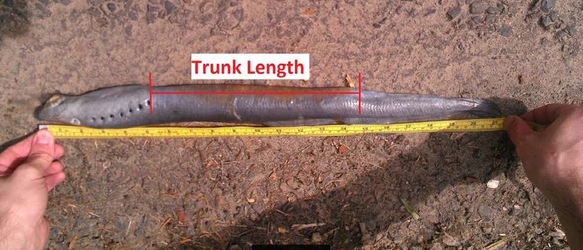
SURVEY PROCEDURES

Organizing Work

Each crew (two members) will have a list of up to 45 surveys. Some surveys will require
floating and others walking. Each survey should be conducted every 7 to 14 days. Though it
may not be possible to survey large water sites at the start of the season, an effort should be made
to get into them as soon as possible. Group surveys into daily work schedules that fit a two-
week rotation. Stream flow and visibility will determine whether or not a survey can be
conducted so be prepared to be flexible. As you become familiar with your surveys you will be
able to change your schedule to accommodate changing water conditions. Remember, some
float surveys might be walkable at lower flows, while some foot surveys can be floated at higher
flows.

Survey Considerations

Most surveys will be conducted on foot using a similar protocol to the salmon spawning surveys
performed in the fall. In addition to counting live fish and recording adipose clipped fish,
individual redds will be marked. Unlike foot surveys, float surveys are conducted moving
downstream and are always done by both members of the crew, each in a one person pontoon
boat. Boating safety is an important part of the job covered in more detail on pages 24-29.

Most crews will have two vehicles, which allows for shuttling. Obtaining landowner
permissions are required for both float and foot surveys. In sections of stream commonly
floated by the public we do not require permission from every landowner, but every landowner
on the survey should be notified that we are in the area so that redd marking materials (i.e., flags
and rocks) are not disturbed. In addition, landowner permissions are required at the put in and
take out locations even if they are not within the survey boundaries. Permission is also required
before entering, crossing or parking on any private property.

To increase the level of safety and maximize the area covered, float surveys are always
conducted by pairs of surveyors. Crews lacking boating experience should conduct initial
floats on potentially dangerous surveys with crew leaders. While conducting float surveys each
person will be wearing waders and a belt, life jacket, spray jacket, and other miscellaneous gear.
It is imperative that waist belts are fastened tightly and life jackets are zipped all the way up. A
tightly fastened waist belt will slow water from filling your waders. The take home message for
all float surveys is that if you feel uncomfortable, portage or line your boat around rapids, or skip
the survey until you can assess it with your crew leader. You should carry a bag of some sort to
hold rocks and a dry bag to carry extra clothes and food on longer floats. On some float survey
days you may want to combine multiple surveys together and make a longer overall float. For
example, if a six mile section of river has three surveys spread throughout its length with gaps
between each one it might be worth it to float the entire six miles (only surveying 3 miles) to
minimize put in and take out time.

The normal procedure for a float survey is to load both of the boats in the back of one vehicle.
Depending on the vehicle, the frames may need to be detached so the boats will fit snuggly.

                                                  4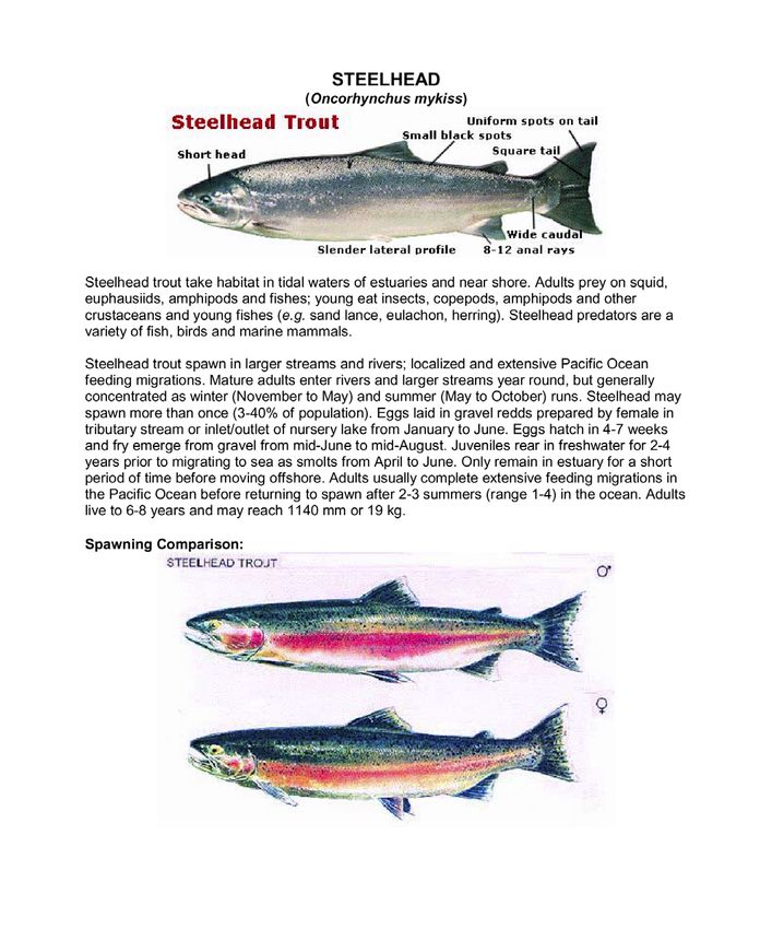
Each crew will be provided plenty of straps to tie down the boats. Drive to the site and drop one
vehicle off at the take out. Drive up to the start point and look for a good put in. If there isn’t a
decent boat launch at the start point, drive upstream to acquire an easier river access point. Once
at the launch site please carry your boats down to the water. Dragging inflatable boats increases
the chance of ripping holes and dramatically reduces their life-span. Once in the water you will
need to find the most productive way to cover each survey. On bigger streams this usually
means one person on each side of the stream so that each person can see to the bank and to the
middle of the stream. The boats are made with a hard floor that allows one to stand while
floating in the slower sections. When approaching high density redd areas, standing in the boats
will greatly increase your ability to identify redds and live fish. When live fish or redds are
encountered communication is key so that everything is recorded accurately and no single fish or
redd is counted twice. It is helpful to first float over the redds to get an accurate count and then
to double check the area once on the bank. Give yourself extra time for float surveys, especially
early in the season as you are getting familiar with these floats and as redd density increases.

We often survey popular fishing areas. Be courteous in how you approach and pass both boat
and bank anglers. Do not float over the water that they are fishing. As you approach, ask them
where they wish you to proceed. If they appear to be ignoring you, keep as far away from them
as possible. Generally with drift fisherman, it is best to get as close to them as possible. With
people back-bouncing or hot-shotting, it is best to keep as far away as possible. Give fisherman
the Right of Way. We do not want to be disruptive or diminish their angling experience.

Fish Counts

                                    Steelhead are more easily frightened than salmon, so take time
                                    to identify fin clips when fish are encountered. Success in
                                    identifying marks on live fish varies between surveyors, but
                                    generally crews can determine fin mark status on 40% of fish.
                                    If you get into the season and realize you’re not identifying
                                    many fin marks it might be time to slow down during the
                                    survey. It’s OK to spend a little extra time trying to identify
                                    fin clips. Your polarized glasses and hat will help
                                    considerably in identification. Look ahead for likely sections
                                    (tail-outs) where you would expect fish to be spawning and
                                    approach these sections slowly. Look for areas near the
                                    stream where you can get in an elevated position. Visibility is
                                    greatly improved from an elevated position. If you cannot
                                    positively identify a fin mark then record it as unknown. In
some areas marked fish returning to hatcheries are given a second mark and then trucked
downstream and released to provide more angling opportunities for the public. Look for colored
tags on any part of the fish, or punches on the operculum (gill plate). If any marks or tags other
than adipose clips are observed please make a comment under notes, and inform your assistant
project leader. All steelhead carcasses should be sampled for biological data. See “Scale
Sampling” (page 20) for sampling details. Other species you may encounter include pacific
lamprey, brook lamprey, and cutthroat trout. Pacific lamprey tend to spawn in the larger streams

                                                  5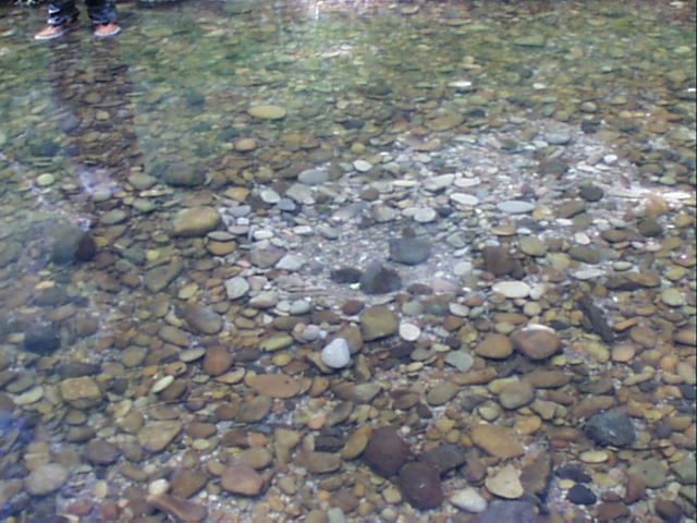
while brook lamprey and cutthroat are generally found higher up, in smaller tributaries. For each
species observed you will be recording the overall live fish activity.

Redd Counts and Marking

                                 To prevent double counting, steelhead redds will be marked
                                 using colored rocks and flagging. Place a rock inside the bowl
                                 of the redd and put flagging in a nearby tree. Use a sharpie to
                                 write the date, species, redd number, rock color and a brief
                                 description of where the redd is located in relation to the flag.
                                 Record all steelhead redds in the Redd Longevity form.
                                 Acquire GPS coordinates and record the redd number, rock
                                 color, initial date, and then later, the date when the redd is no
                                 longer visible. If you find that you are having difficulty
                                 acquiring a GPS signal, try using the app GPS Test. By
                                 starting this app first, your phone will more readily acquire a
                                 signal and make the GPS coordinate acquire better in
                                 Pendragon. You will also record the redd confidence code.
                                 This code indicates how sure you are that the redd is in fact a
                                 redd. (1= completely confident, 2 = probable redd, 3 =
                                 uncertain if a redd). In areas with high redd densities please
                                 write additional comments (e.g. 2m out and 1m upstream from
                                 flagging) that will help identify which redd is which. Each
                                 redd will receive a number to identify it. Number the redd with
                                 a combination of your surveyor ID, the date, and a consecutive
                                 number (see “Unique ID code” description below). When a
                                 redd is no longer visible record a removal date in the Redd
                                 Longevity form and remove the flagging. All flagging and as
                                 many of the colored rocks as possible should be removed
                                 during the last site visit for the year. For redds that are still
                                 visible during the last site visit, record the date and check the
                                 “Still Visible on Last” box in the Redd Longevity form.
                                 Removal of flags and as many rocks as possible is critical to
                                 maintain good relationships with land owners and ensure
                                 continued access to conduct these surveys.

                                 All visible lamprey redds will be tallied on each visit.
                                 Basically, if it is a lamprey redd tally it, regardless of whether it
                                 was tallied on a previous visit. Lamprey redds will not be
                                 recorded on the Redd Longevity form. They need not be
                                 marked with colored rocks, but if marking a lamprey redd use a
                                 color which has been agreed on with your crew leader as
                                 lamprey-only.

                                 Steelhead redds are typically 3 to 4 feet wide and 6 to 8 feet
long (page 18). Fresh individual redds are usually easy to identify because the overturned gravel

                                                6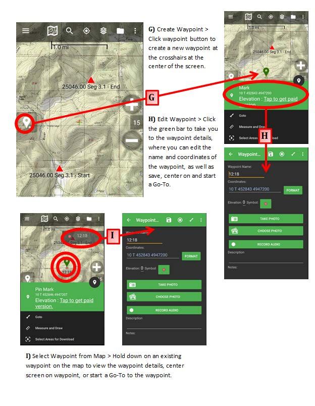
will be lighter in color compared to adjacent substrate. Preferred sites for redds are located in
gravel beds at the tail end of pools or the head end of riffles (tail-outs). This description is an
example of what to look for in a perfect situation, but steelhead will spawn in areas that are far
from typical. It will be important to look for steelhead in all areas of the stream. An example of
an atypical spawning site would be areas that are less than 2 m2 in total area. This can occur in
tributary as well as the larger water surveys. You will also find fish spawning in areas where the
gravel depth is less than eight inches. Fish encountered spawning at higher stream flows is
another issue. This can occur during some of the float surveys when fish are seen spawning but
you are unable to get a rock effectively in the bowl of the redd. The best method in these
situations is to put a flag on the bank and make note of the redd. If you are unsure of a redd you
can always mark it and then have the option of taking it out of your data, if after checking it on
the next visit it is determined to not be a redd. You will encounter these situations as well as
other cases in which steelhead seem to be defying our conventional definitions.

All steelhead redds will be given a unique ID code. The proper naming convention for redds is
as follows: surveyor #-date-redd number for that day and survey. For example; Surveyor
number 7 is performing a survey on 4/5/2020. After walking 100m she finds the first redd of the
day at this site. The Redd ID for this redd would be: 7–0405–01 since it is surveyor 7 on 0405
(April 5th) and the first redd of the day at that site. The second redd seen during this survey
would be 7–0405–02 (and so on). It is important that the date component of this code include
four digits so there is no confusion between dates (e.g., 112 could be Jan 12, or Nov 2).

In 2016, we added a new field to the redd longevity form to record redd confidence. The field is
a popup list called “Confidence” and is located after Species and prior to Initial Date on the first
page of the redd longevity form. It is intended to be used as a way of grading how confident you
are in your redd call. The pop-up list allows you to choose one of three options: 1 = Confident, 2
= Probable, or 3 = Uncertain.

 A “Confident” call means you are certain the redd is fish made with well-defined pot and/or
               tail spill edges.
 A “Probable”      call means you are fairly certain the redd was fish made, but the pot and/or tail
                   spill edges might not be very well defined.
 An “Uncertain” call means you see some sort of substrate alteration that is likely fish made;
                however, you are tentative as to whether it is an actual redd, test-dig, or the
                beginnings of a redd.

With all subjective data, there is definitely going to be some ambiguity; the important part is that
you make your redd confidence calls consistently. We don’t intend to use this new field as a
filter, but rather as a way of assessing the proportion of redds on the landscape that we are
confident in. Thus, a redd with Confidence=3 will be treated the same in our data summaries
and estimates as a redd with Confidence=1 or Confidence=2. This ranking system might help to
identify streams or areas where making redd calls is more difficult.

Pacific Lamprey redds can usually be distinguished from steelhead redds because the rocks will
be placed by the fish upstream, downstream and to the sides of the depression (page 18). Pacific
Lamprey redds are typically about 24 inches in diameter and have a neat round appearance.

                                                 7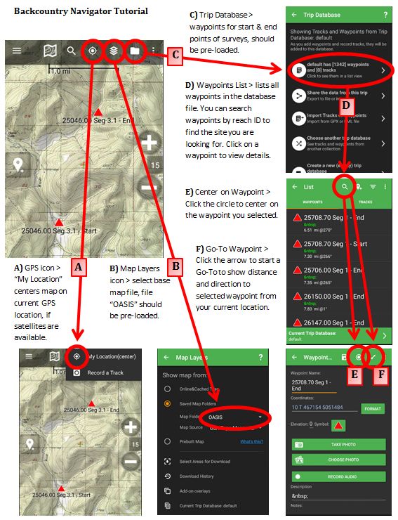
Much of the time you will find lamprey redds in clusters within nice tail-out sections, and it is
not uncommon to see more than a few lamprey on a redd. Pacific Lamprey tend to spawn in the
larger tributary and mainstem sections of streams. It is also common to find lamprey spawning
inside of an existing steelhead redd. The most effective method in these cases is to first identify
areas with high densities of both species. It would be helpful if during these situations you are
able to decrease the amount of time between survey dates. It would be better to get back to this
survey in a week to increase your chances to actually see fish on redds. In addition to pacific
lamprey you may find brook lamprey in some of the smaller tributaries. This species is much
smaller in overall size (~ 6 inch length) and spawns in smaller gravel. The redds are less than a
foot in width. Although much smaller, brook lamprey still use the same method of gravel
excavation by using their mouth to suction rocks. Similar to the pacific lamprey, rocks will be
placed upstream, downstream and to the side of the redd, something that will not be seen in
steelhead or cutthroat redds. Cutthroat redds are typically found in the smaller tributary streams,
and while similar in shape to a steelhead redd, they are usually much smaller in size and built in
areas of smaller gravel.

Steelhead Survey Data Form Codes

WEATHER
       Describe the weather as:
              C - Clear
              O - Overcast
              F - Foggy
              R - Rain
              S - Snow
              P - Partly Cloudy
FLOW
       Describe the stream flow as:
              L - Low or Dry - Stream does not cover nearly all of the stream bed.
              M - Moderate - Stream covers nearly all or all of the stream bed.
              H - High        - Stream width approaches or reaches active channel
                                 width and stream height approaches bank full.
              F - Flooding - Stream is out of its banks.
VISIBILITY
       Describe stream visibility as:
              1 - Can see bottom of riffles and pools.
               2 - Can see bottom of riffles, but not pools.
               3 - Cannot see bottom of riffles or pools.

LIVE FISH ACTIVITY
       Overall live fish activity of each species observed must be recorded.
               13 - Most fish spawned out.
               14 - Most fish holding in pools (prior to spawning).
               15 - Most fish migrating through survey area.
               16 - Most fish actively spawning (as demonstrated by courtship behavior,
                     excavation of redds, competition for mates, and guarding of redds).

                                                    8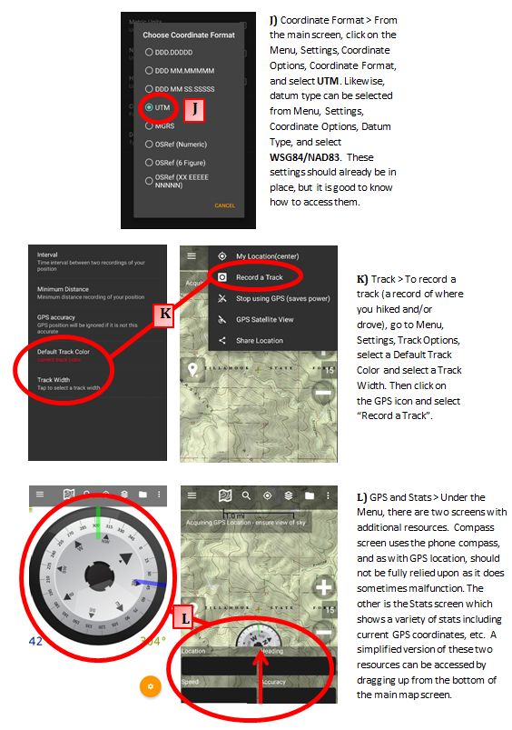
COMMENT CODES

Use comment codes from the following list. There is room for three comments per survey.
Prioritize comments on the Steelhead Survey Form according to the priority of the categories
listed below. If further comments would be useful, record the comment code number (i.e. CC-
64) or type in text comments in the Comments field below the comment code dropdown boxes.

Area Surveyed
       01 Includes tributary to index. (Used when fish are observed in trib of survey).
       02 Holes not surveyed. (Used when water is too high to survey holes)

Factors Affecting Fish Abundance
        48 Stream Flow insufficient for adult entry to date. (Still need to walk every survey)
        49 Possible Passage barrier below survey. (Let your crew leader know)

Viewing Conditions
       20 Dark (pertains to the light source, not the water clarity).
       21 Dark in pools (pertains to water quality, often tannins).
       22 High glare.
       23 Partly frozen.
       24 Not surveyable (stream too high and/or turbid, counts will be disqualified).

Stream Conditions within the Survey Area
       31 Impassable logjam.
       32 Passable logjam.
       33 Impassable beaver dam.
       34 Passable beaver dam.
       35 Impassable culvert.
       38 Passable culvert.

Miscellaneous
        52 Live tagged fish observed.
        57 Live fin clip (non-adipose) fish observed.
        60 Most carcasses washed out.
        64 Exposed redds due to low flow.
        66 Counts probably higher than observed.
        71 Redds estimated-high density.
        88 Survey not conducted due to impassable road.
        99 Placed steelhead carcasses observed.

                                                    9
SPAWNING SURVEY EVALUATION FORM
REACH ID SEGMENT # SURVEY NAME
ID # OF SURVEYOR COMPLETING FORM DATE OF FORM
PROBLEMS WITH SURVEYING THIS STREAM SEGMENT:
_____________________________________________________________________________________________
_____________________________________________________________________________________________
_____________________________________________________________________________________________
_____________________________________________________________________________________________
_____________________________________________________________________________________________
BARRIERS TO UPSTREAM MIGRATION:
APPROX. DID IT BECOME WERE SALMON
LOCATION NATURE OF BARRIER PASSABLE? WHEN OBSERVED
(0.1 MILE) (DATE)? UPSTREAM FROM IT
RANKING OF SPAWNING GRAVEL QUANTITY (check one):
Category Description
None No Spawning Gravel
Low >0 and < 20 m2 Spawning Gravel
Moderate 20 to 100 m2 Spawning Gravel
High > 100 m2 Spawning Gravel
DISTRIBUTION OF SPAWNING GRAVEL (% OF TOTAL):
DOWN- LOCATION WITHIN SURVEY SEGMENT UP-
STREAM START TO 1/4 1/4 TO 1/2 1/2 TO 3/4 3/4 TO END STREAM
BOUNDARY BOUNDARY
DISTRIBUTION OF SPAWNING FISH (% OF TOTAL):
DOWN- LOCATION WITHIN SURVEY SEGMENT UP-
STREAM START TO 1/4 1/4 TO 1/2 1/2 TO 3/4 3/4 TO END STREAM
BOUNDARY BOUNDARY
FISH DISTRIBUTION BASED ON: FISH REDDS (CIRCLE ONE)
HABITAT RANKING (circle): NO HABITAT VERY POOR POOR OK GOOD VERY GOOD EXCELLENT
GENERAL COMMENTS AND ADDITIONAL CODED COMMENTS (USE REVERSE SIDE)
10Spawning Survey Evaluation Form Instructions
This important form is used to evaluate the spawning habitat for salmon and steelhead in a given
season and survey segment. It is also used to note any factors that may influence our ability to
obtain accurate estimates of spawner abundance in the survey segment. One form is to be
completed for each survey segment at or near the end of the spawning season. The surveyor who
is most familiar with the survey being evaluated should complete this form. Use input from
other surveyors as needed. Please make sure to fill in the Surveyor ID on every form. The
Reach ID, Segment, and Survey Name should be preprinted on the form.
DATE OF FORM
Enter the date on which the form was completed.
PROBLEMS WITH SURVEYING THIS STREAM SEGMENT
List any major problems that prevented the survey from being conducted or caused the survey to
be difficult (road conditions, extended high stream flows and/or turbidity, problems with access
through private land, etc.). Identify any factors related to the condition of the survey segment
that may have hindered your ability to make accurate counts of salmon (water clarity, structure in
the stream channel, viewing conditions, etc.). Note if and when the stream became too low for
STW passage. Make a special note of exposed redds.
BARRIERS TO UPSTREAM MIGRATION
List up to three potential barriers to upstream migration; this may include barriers which formed
during the course of the spawning season. Barriers are best identified by the presence of adults
immediately downstream from an obstacle but not upstream of the obstacle. Record the
approximate location of the barrier from the survey starting point (nearest 0.1 miles from the
start), nature of the barrier (i.e. beaver dam, culvert, log jam, waterfall, etc.), and the date when
the barrier became passable (date when fish were first observed upstream from the barrier or
when high flows removed the barrier). It should also be noted if barriers develop later in the
season due to lower flows. If you feel the barrier prevented fish passage for the entire season,
note as such. If the endpoint of the survey is a barrier, mention that too.
ESTIMATES OF SPAWNING GRAVEL QUANTITY
This estimate should be done at the end of the season, but should reflect spawning gravel
quantities throughout the season. This is a rough quantitative estimate within large ranges of
gravel abundance. See the description of typical steelhead spawning gravel (page 6-7) to help
determine the quantity present in each survey.
DISTRIBUTION OF SPAWNING GRAVEL
Estimate the proportion of spawning gravel in each quarter of the survey to the nearest 1%.
11DISTRIBUTION OF SPAWNING FISH
Estimate the proportion of spawning fish in each quarter of the survey to the nearest 1%.
Remember to indicate whether fish or redds were used to make the estimate.
HABITAT RANKING
Please circle the most appropriate ranking based on the description of the perfect spawning
habitat in relation to gravel size, quantity, abundance, tail outs, and gradient.
GENERAL COMMENTS
Use the reverse side of the form to record observations that will help you complete the
evaluation. List any comments that will help in interpreting your responses, and list any other
noteworthy features of the survey segment. Some possible questions to consider include: What
are your impressions of the habitat? Did the habitat significantly change during the season, and
if so, how? Are spawning habitat improvement structures present, and are they functioning to
improve spawning habitat? If no adults were seen, do you have any idea why? Were there any
tributaries within the segment that steelhead use for spawning? Were the names, addresses,
and/or phone numbers of landowners mentioned in the description correct? Was this survey
unusual compared to other surveys you have done? Attach additional sheets as necessary. In
many cases you will see certain sections of a stream more than any other person. You may end
up learning things about a stream that no one else knows. If you feel that you have information
that would increase the quality of data, correct possible errors in the stream database, or increase
our understanding of a certain stream, the survey evaluation form is where that information
should go.
DESCRIPTION CHANGES
Survey descriptions sometimes contain outdated or incorrect information which must be updated.
Common description changes include (but are not limited to) correcting UTM coordinates,
revising driving directions, updating information about access gates or keys, or moving sign
locations. Record these changes on the Description Change Form. Your survey notebook
contains a pre-printed description change form for each survey on your rotation. Fill out the
form completely. When writing a description, be detailed and precise. If minor changes are to
be made, highlight the area being altered in the existing description, and indicate changes on the
lines below. Proper grammar and legibility are important. Read the descriptions to your surveys
to get an idea of what makes a good description. If no changes need to be made, simply check
the box for No Changes.
12LANDOWNER CONTACTS
We contact landowners for permission before conducting surveys that are located on private
land. You will be given pre-printed Landowner Contact forms for all steelhead surveys that have
also been surveyed for Coho or newly set up this year. In most cases, permission for steelhead
walking surveys has been established during the Coho survey season; you should verify this with
your crew leader and the landowners if necessary. The information printed on these forms
represents our best information about who the property owners are along the survey route. The
preprinted information often needs updating, for example when property is sold or transferred to
new landowners, or if the landowners have relocated. There may also be forms where most of
the landowners were contacted but one or two do not have a current OK date. Please make sure
that you contact those landowners and get permission. Steelhead surveys that were setup in
previous years or have not been done for Coho will require you to obtain permission and
document the landowner contacts. Ask landowners if there are specific stipulations or
conditions they want to establish prior to allowing access and be sure to record these in the
comments section of the Landowner Contact Form and include these comments on the survey
description change form. Complete the form by verifying tax lot, address, phone no., and record
the date permission was granted or denied by the landowner.
When you contact landowners, introduce yourself in a professional manner and identify that you
work for ODFW. Briefly describe the purpose of the survey, and emphasize that ODFW is using
the information to better manage fisheries and monitor the status of large scale steelhead
populations, not to evaluate fish in relation to conditions on their property. Explain your reason
for being there, and be clear on your intent, methods, and the frequency of your visits. Inform
landowners that surveys will be conducted through May to accommodate steelhead spawn
timing. Be aware that some landowners may have been contacted previously by other projects.
An information pamphlet discussing the Oregon Plan for Salmon and Watersheds is also
available for the landowner’s information. This pamphlet gives an overview of the goals of the
Oregon Plan and also explains the three ODFW monitoring projects: adult, juvenile, and habitat
surveys that are conducted as part of the Oregon Plan. Pamphlets may be obtained from your
crew leader. Be sure to check the box next to the Adult Salmon Spawning Surveys section of the
pamphlet prior to handing it out, and include your name and cell phone number.
On large streams that are commonly floated for public fishing, permission from every landowner
is not required but all landowners should be notified that we will be placing rocks and flagging.
If a landowner denies permission you may still be able to float through that portion of the stream,
but do not mark redds or sample fish. Consult with your crew leader in these situations and
make sure you clearly mark on the landowner sheet that you are skirting that property. Also,
landowners at the access points (put in and take out) will have to be contacted. Use your best
judgment and talk to your crew leader if there are any questions about landowner contacts.
Inform all landowners about the use of flagging and colored rocks to mark redds. Obtain
permission to attach flagging to streamside vegetation when it may be in view of the landowner.
Obtain specific permission for the use of flagging. Be sure they know that flagging will be
13removed at the end of the season. If access to the survey is through private property, obtain
permission and post Survey Signs if the landowner approves.
ODFW is sensitive to landowner concerns regarding access to their property and all ODFW
employees must be respectful of landowner property rights. The following general guidance is
designed to help us conduct surveys as efficiently as possible, while providing assurance and
documentation that we have made appropriate landowner contacts.
Overall, never question a landowner’s statements about their property rights. Issues of
navigability, prior use, location of property lines, etc. are all secondary to what the landowner
understands to be their property rights. Under no circumstances should you question or dispute
landowner claims. Instead, respect their instructions in all cases – it is better to modify a survey
or drop it altogether than to engage in a dispute with a landowner. Keep your crew leader
apprised of conflicts if they arise.
Often, the best source of information about landowners along your surveys will be the ODFW
District Biologists, their staff, and your crew leader. Review your survey plans with district staff
prior to beginning the survey season. Make special note of staff concerns or advice they may
have regarding each survey reach.
Surveyors are expected to be professional at all times during landowner contacts. Wear your
uniform. Be courteous and brief. Introduce yourself; explain the project, survey activities and
how long you expect to be surveying the site. Honor and document all landowner requests,
within reason. Ask prior to putting up signs. If you plan on using the property as an access point
be sure that the landowner understands this and grants specific permission. Be sure to remove
all flagging and colored rocks we placed by the end of the season.
Using the Landowner Contact Form
- Record all contacts on the Landowner Contact Form.
- Write in any additional landowners that don't appear on the form with as much contact
data as you can obtain (address, phone, tax plot, ok date, etc.).
- Edit and highlight any landowner information that is incorrect.
- If there are many corrections or edits it is better to start over with a new Contact Form.
- If there is a landowner on the Landowner Contact Form that is not needed, please mark
through it with a red pen and indicate that it is not needed. Remember that there might be
additional landowners on the sheet that are needed for access points only and may not be
along the stream. Some of these landowners may be on the contact sheet because they
request data.
Verify the information:
- Make sure the names, complete address, and phone number(s) (including area code) are
all correct.
- If this information is incorrect, record the correct information on the landowner contact
form and highlight them so they may be updated in our database.
- If the landowner lives offsite, record that address in the comments section.
- Obtain the tax lot information if it is not provided.
14Check the most recent OK date:
- Landowners that gave permission during survey verifications this summer or Coho
surveys this fall do not need to be contacted again unless there are specific instructions to
do so in the landowner comments or the survey description.
- If the list does not indicate that a corporate landowner has been contacted, obtain
permission from the crew leader before conducting the survey.
- If the contact person is different from the owner or organization name, their name and
phone number will either be in the Contact Details section or in the Comments section.
Record the date landowners were contacted:
- Once a landowner has given permission, fill in the date under "New OK date". Do NOT
just checkmark the box, write “yes” or “no”, or leave blank!
- If a landowner denies permission, note this under "Comments" with the date of the denial
and do not trespass on their property. A denial can result in modifying the survey
boundaries or dropping the survey. Consult your crew leader about denials so we can
determine our best option. If skirting property please indicate this in the comments
section.
Enter “Yes” or “No” in the “Data Requested” column:
- Do NOT enter a check mark or leave this column blank!
- If “Yes”, make sure you have the current address of the owner (including the zip code).
- Please highlight this area if they are requesting data.
Check the "Comments" section for any special instructions:
- Accommodate any special requests and write them down (e.g., the owner requests that
surveyors not park in the driveway). You can’t have too much information!
- If the landowner requests to be contacted before every survey, make sure you attempt to
call them and leave a message with the specific day that you will be conducting the
survey.
Submit the Form to your Crew Leader:
- When you have obtained all the necessary permissions, write your surveyor ID in the
"Contacts Complete by Surveyor ID" checkbox.
- Complete this part of the form even when there are no landowner contacts that need to be
made (for example, if the survey falls entirely on public land).
- Do not wait to turn this in!
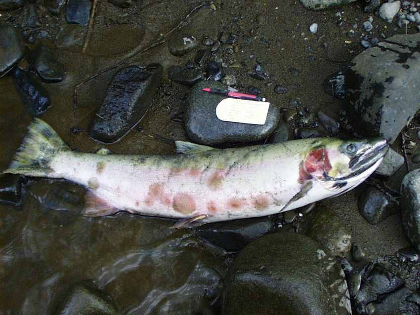
15STEELHEAD IDENTIFICATION
16Steelhead Carcass Photos
17Redd Photos
Steelhead Redd
Lamprey Redd
18Fin Nomenclature
19CARCASS SAMPLING
We will sample and record in the PDA all steelhead and lamprey carcasses that we find. Scales
will be sampled from all steelhead carcasses. See next page for further instructions for lamprey
sampling in the Lower Columbia.
• Record species and sex of the fish
• Record MEPS length in mm (total length for
lamprey in mm)
• Record any fin-clips
• Cut-off tail from all fish that are scale sampled to
avoid re-sampling
•Sample scales from the key area. The key area is
located just above the lateral line on both sides of an
imaginary line drawn from the anterior margin of the anal fin to the posterior margin of
the dorsal fin. You should take about four scales from each side of the fish and place
them in the scale envelope insert.
• Record Surveyor ID (Sampler), Date, Species, Basin, Reach ID and Segment on scale
envelope
Example of a scale envelope with data fields completed
Sampler 007 Date 02/25/20 No. 00001
Species __4 (stw)___ Basin ____Siuslaw____
Reach__22504.00________ Seg ___2__________
Comments: Female, 750 MEPS, Un-marked, no tags
OREGON DEPT. OF FISH AND WILDLIFE
20Lamprey Sampling Protocol
-Enter all dead lamprey into the carcass sampling records. Take a total length (TL) in the MEPS
length section of pendragon forms and record a Trunk Length vent (anus) to end of last gill
opening) in the comments section and record codes that may be pertinent to your
sample(scavenging, etc.….).
21DISTRICT CONTACTS
NAME TITLE NUMBER
OSP Tip Line Oregon State Police anonymous tip line 1-800-452-7888
Motor pool questions Oregon motor pool accidents/maintenance 1-800-378-0077
Tom Murtagh Mid-Columbia/Sauvie District Fish Bio. (971) 673-6044
Ben Walczak North Willamette District Fish Biologist (971) 673-6011
Michael Hayworth North Willamette Asst. District Fish Biologist (971) 673-6013
Chris Knutsen North Coast District Manager (503) 842-2741
Robert Bradley North Coast District Fish Biologist (503) 842-2741 x 253
Mike Sinnott North Coast Asst. Fish Biologist (503) 338-2741
John Spangler Mid Coast District Fish Biologist (541) 867-4741
Paul Olmstead Mid Coast Asst. Fish Biologist Newport (541) 867-4741
Greg Huchko Umpqua District Fish Biologist (541) 440-3353
Jason Brandt Umpqua Asst. Fish Biologist (541) 440-3353
Mike Gray Coos-Coquille District Fish Biologist (541) 888-5515
Gary Vonderohe Coos-Coquille Asst. Fish Biologist (541) 888-5515
Steve Mazur South Coast District Biologist (541) 247 7605
Laura Green South Coast Assistant Fish Biologist (541) 247 7605
Dan VanDyke Upper Rogue District Biologist (541) 826-8774
Dave Haight Upper Rogue Asst. DB Central Point (541) 826-8774
Mark Lewis OASIS Program Manager (541) 757-4263 ext 223
Briana Sounhein OASIS Project Manager Coastal Coho (541) 757-4263 ext 227
Matt Weeber OASIS Project Analyst (541) 757-4263 ext 248
Ryan Jacobsen OASIS Assistant Project Leader Lower Columbia (541) 207-4441
Jon Nott OASIS Assistant Project Leader Oregon Coast (541) 231-3412
Michelle Best OASIS Project Assistant (541) 757-4263 ext 226
Shannon Richardson Coastal Chinook Res. & Mon. Project Leader (541) 757-4263 ext 242
Brian Riggers Coastal Chinook Res. & Mon. Project Biologist (541) 757-4263 ext 265
Ben Clemens Fish Biologist & Statewide Lamprey Coordinator (541) 757-4263 ext 232
Frank Drake Crew Leader for Lower Columbia West- Astoria (541) 360-1646
Alex Neerman Crew Leader for Lower Columbia East- Clackamas (541) 760-7723
Scott Kirby Crew Leader for North Coast- Tillamook (541) 231-1958
Ryan Emig Crew Leader for Mid Coast- Corvallis (541) 760-7746
Joshua Edwards Crew Leader for Siuslaw and Umpqua- Eugene (541) 760-7525
Morgan Davies Crew Leader for Mid South Coast- Coos Bay (541) 231-1803
Sara Hart Crew Leader for Willamette Winter Steelhead (541) 207-8563
22PUBLIC RELATIONS AND SAFETY
When you are conducting surveys, you are personally representing the Oregon Department of
Fish and Wildlife to landowners, anglers, and the general public. In order to insure continuing
public cooperation with our efforts, it is essential that we maintain a positive image and
relationship with the public.
If a landowner challenges your right to conduct surveys on their land, explain your
understanding that permission was obtained prior to you starting to conduct surveys, apologize
for the misunderstanding, and request permission to continue the survey. Under no
circumstances should you conduct a survey if the landowner denies permission. If someone
other than a landowner challenges your right to conduct a survey, explain your understanding
that permission was obtained from the landowner, and tell him or her that you will seek
confirmation of permission through your supervisor. Under no circumstances conduct a
survey if you feel that it is unsafe to do so.
Always treat members of the public with respect. It is not uncommon to encounter a person who
has complaints about ODFW or other fish and wildlife management issues. If you encounter an
angry person, end the encounter if you feel unsafe. Otherwise, repeating or paraphrasing back
what the person says will help you gain that person’s trust by letting them know that you hear
and understand what they are saying. Find a point of agreement and end the conversation.
Avoid prolonged discussions; your time and skills as a surveyor are valuable.
Respect traffic, especially on logging roads. Generally, emergency vehicles, low boys, log
trucks, and pick-ups have the right-of-way in that order. Use your CB radio when you are on
industrial forest roads! An example of how you might use your CB to warn unseen vehicles of
your approach is “Milepost 17 up the Eighty-one Fifty-five Road”. You cannot count on other
vehicles using their CBs.
Respect your limits when conducting a survey. Don’t push your luck when crossing strong
streams, slick rocks or bedrock, and slick, unstable, or rotten logs. Keep all of your senses aware
at all times (that bear needs that salmon more than we need the data).
KEEP SAFETY IN THE FOREFRONT OF YOUR MIND
AT ALL TIMES
23BOAT SAFETY AND TECHNIQUES
Float surveys are a safe and effective method for conducting steelhead surveys on large streams.
The boats we use are well suited to this task, but the performance of the boat must be matched
with safe boating technique and good judgment on the part of the surveyor. As with foot
surveys, it is ultimately the responsibility of each surveyor to use their own judgment to safely
conduct all surveys. If the surveyor is unsure of a situation, then the more conservative choice
should be made. This may mean that the survey is not done at all. As the survey season
progresses each surveyor’s river skills will improve. This new confidence will bring increased
comfort and efficiency on the water, but it can also be misleading. Even the most benign
sections of river have features that can be deceptive, or even dangerous. In addition, rivers can
change quickly; even within the same day. Landslides, falling trees, variable flows, and human
intervention can all impact the safety of floating a given section of river.
Safe conduct of float surveys depends on maintaining gear in good condition, appropriate
clothing, effective communication among survey partners, boating skill, knowing stream
conditions for each float, and good decision making processes. Training and practice are the best
methods for learning float survey safety and boating techniques. Surveyors will receive direct
instruction and evaluation by crew leaders before they will be asked to conduct surveys on their
own. The following sections provide some basic guidance for this process.
Gear Care and Preparation
Transporting Boats: Preventing damage to equipment during transport is key to overall care of
the equipment. More damage occurs during transportation than on the river. Use straps or rope
to tie down boats on vehicles regardless of the relative length of travel. Running rope through
the frame is a good idea to insure that the boat cannot work loose from the tie-downs. Stacking
boats works well when a single vehicle transports more than one boat. A common method used
when boats have frames is to place the first boat in upright with the bow facing forward, then
turn the second boat upside down and face the bow to the rear of the truck, place it on top of the
first boat, running rope through both boat’s frames. Another method is to turn the boats on their
sides, bottoms together. A third (and safest) method removes one boat’s frame then stacks the
boats together with the removed frame tied into the top boat.
Inflation: Boats with too little pressure will be unstable and sluggish on the water. Boats with
too much pressure are likely to blow out. A correctly inflated boat’s shape will bend slightly if
lifted from one end, but will not sag. Temperature greatly influences boat pressure, and it is
important to monitor inflation throughout the day. Cold water will cause pressure to decrease,
sun exposure will cause it to rise. If leaving the boat in the sun for a time, pressure should be
reduced to avoid blowing out tubes. The most common cause of boat damage is over inflation
associated with boats left on vehicles on warm days. Reduce raft inflation any time boats are
being carried or transported in a vehicle, and monitor the pressure throughout the day. It only
takes a moment to top off a soft boat, but patching blowouts is often difficult or impossible.
Air Pump Maintenance: The tube pumps provided are relatively quick and durable, but some
maintenance is required. If pumps become sticky, or if they fail to move air, unscrew the top cap
24(near the handle) and pull the plunger out. Lubricate lightly with automotive grease and place
the plunger back as it was. If the pump is failing and no grease is available, use water or any
other available lubricant in the same manner, and clean and grease the plunger later upon return
to your workstation. Adapters are often provided with the pumps, but may not fit the valves on
individual boats. If no appropriate adapter is available, use a 2 cm wide strip of duct tape, and
wind the tape around the hose or undersized adapter until it fits snuggly in the boat’s valve.
Patching: The boats are made from sturdy material, but should never be dragged over the
ground. Nevertheless, punctures and abrasions are inevitable from normal use, and should be
patched immediately. Quick patches can be made with duct tape, but more lasting repairs
require adhesives and several hour drying times. Each boat has a patch kit and instructions
inside a dry-bag. The boats are made of a PVC material, which responds only to special glue
(Staybond), so please do not use adhesives meant for hypolon or other rubber materials. Each
boat has two main components, the outer shell and the inner bladder, and each of these uses
different patching material, but the same glue. Access the bladder by unzipping the shell walls.
Hints for successful patching include using rubbing alcohol to thoroughly clean surfaces, lightly
sanding the surface material, round the corners of all patches, and once the patch is in place
apply and sustain pressure on the patch overnight. When a boat blows out due to over inflation
the rupture typically occurs near the ends of the bladder. This hole is usually too large to patch,
but can sometimes be fixed. Twist the end of the bladder as if you were wringing out a rag,
twisting past the blowout area. Use a strap, rope, flagging or zip-tie and tightly tie off the
twisted area, like a tourniquet. If leaking persists, place another tourniquet a few inches below
the first. A tear of the boat’s outer shell should be repaired by placing a patch on the inside of
the shell to insure the patch does not catch and tear off; large tears sometimes require stitching
the material prior to patching.
Oars and Paddles: Each oar boat should have three oars (two, plus one spare). Each oar has a
plastic sleeve that is locked down by an oar-stop plastic collar (sometimes called a donut). All
three oars should have the sleeves and collars in the same relative location on the shaft to insure
that the oars fit with the same balance on the frame and oarlocks. To adjust this balance, loosen
the screws on the collar and slide the donut and sleeve as necessary to properly fit in the
oarlocks. Once adjusted, tighten the screw to clamp the system down. Oars set at different
lengths will make for very poor performance. Kayak paddles typically have adjustments for
either flat blades, or control by either left or right hand. These settings are based on personal
preference, though there are some tradeoffs between flat and angled blade settings. Basically,
the angled settings provide relief from headwinds, but can lead to some wrist fatigue, while the
flat orientation is easier to learn.
Common Dangers and Concerns
Gear: Improperly set up or damaged gear is a common cause or contributor to boating
accidents. Maintain proper boat pressure, insure oars are correct size and configuration, and
bring a repair kit and pump at all times. A spare oar and oarlock should always be carried on
floats. Secure these items in the boat; if they fall out they will be of no use. If wearing waders,
use a waist belt, a spray jacket, and always wear your lifejacket (no exceptions). Dress
appropriately, and bring a dry bag with spare clothes if the float will be long or isolated. Keep
25boats well maintained. Ropes should be safely wrapped and away from feet, but ensure that they
are easily accessible.
Logs: Downed logs and logs partially suspended over the channel (strainers and sweepers) are
one of the more common and dangerous features found on Oregon streams. Strainers should be
given a wide buffer at all times because hidden portions of the tree are often present below the
water surface. Sweepers and brush along the stream banks can be equally dangerous,
particularly when positioned on corners where the current moves towards the hazard. Keep track
of where the current wants to take you and never place yourself or your boat upstream of
sweepers or brush.
Blind Turns, Blind Drops and Canyons: Never proceed downriver without a safe, easy route to
shore. If the river bends or drops in a way that obscures your vision, stop a safe distance from
the bend or drop and scout on foot. Always leave yourself an out. If the river enters a canyon,
do not enter unless visibility is clear to the next easy access point. Logs in particular can move
or fall in and create sweepers at any time, so scout blind spots on each visit.
Walking, Scouting, and Portaging: Most injuries on rivers are related to scouting or portaging
boats, not from floating and rowing. The transition from sitting in the boat to walking around
objects can be difficult. Take some time to “get your land legs working” and use appropriate
care when waking or carrying the equipment.
Man Made Objects: Aside from sweepers, the most common and dangerous river features are
often created by humans. Bridge abutments, cement walls with rebar, fish traps, habitat
abutments, and fences all pose relatively common threats to boaters. One of the most innocent
looking and yet deadly river features are low-head dams, often used near hatcheries or for
irrigation diversion projects. Dams as small as one foot tall can create hydraulics which look
insignificant, but can hold you and your boat underwater indefinitely. This can be absolutely
deadly. Never attempt to run a low head dam, and give all other human-made objects a
wide berth.
Stream Flow: When river flow goes up or down, the character of that river may change as well.
Having done a survey at a moderate flow does not predict the difficulty of floating that same
section at higher flows. In most cases higher flows will make individual rapids more difficult
and dangerous, but at times this trend may reverse, with individual rapids becoming more
difficult as flow reduces. The bottom line is that care should be taken when floating sections of
rivers at varying flows. Treat blind spots and canyons as if you have never floated them before,
and scout often. High flows are particularly dangerous because the speed of the river gives the
boater much less time to react to sweepers or blind spots. Often, high flows correspond with
poor visibility and the survey should not be done. However, there are times where extended
periods of higher flows may allow streams to clear, and a survey can be carefully done under
such conditions. Keep track of stream gauge readings, and check flows prior to launching. If
the stream is clear but high, use caution, and if there are doubts about the safety of a float
at high flows the survey should not be conducted.
26Boating Techniques
The most reliable approach to boat safety combines a respect for the river with good
understanding of one’s own abilities. Pay attention, and acknowledge your own limitations.
Also, ask yourself three questions: 1) “Is it possible that I might mess up or get hung up on an
object”, 2) “What will happen if I blow it?,” and 3) “How will I get myself out of a bad situation
if it occurs?” If you are even slightly uncomfortable with the answer to any of these questions it
is time to either scout, portage, or not put-in at all.
One of the best ways to avoid having to make such decisions is to pay attention when setting up
new floating surveys. In cases where roads follow along the stream, the boundaries of a survey
may be moved to an access point just above or below a threatening river section. Most of our
streams are not particularly threatening, but in some cases there are individual river features that
should be avoided.
Scouting: Should occur whenever there is doubt about either what lies ahead, or about the safest
path through. Features that are obvious from the bank can disappear when viewed from
upstream, so always note all trouble spots, and take the time to learn how to identify these
features from a low upstream vantage point. Also remember that the scale of a rapid or river
feature can be diminished when viewed from a distance or from above. That hydraulic or
boulder that looks insignificant from the bank could be large enough to be a danger when
encountered in the boat. Sometimes scouting reveals no clear safe path and a portage is
necessary. Often lining the boat, or using ropes to float the boat near the
stream edges is the best technique. Use as long a section of rope as
possible, and if lining over drops or fast chutes, use a rock or log to create
friction, as seen in the image at left. In this way the strong pull of a boat
in heavy water can be belayed safely and easily. If portaging is
necessary, please do not drag the boats. Dragging boats on dry land
wears or punctures these boats quickly. In the end it will be you who goes
for a swim if your equipment wears out.
Several basic boating tactics will help you get down the river comfortably. Using eddies to slow
your progress in fast sections is referred to as eddy hoping. Once in an eddy, pick your path,
searching for the next eddy, and then proceed to that eddy. In this way you can effectively scout
a rapid without getting out of the boat, but remember, this tactic is more dangerous than helpful
if: 1) there is any chance that you might miss the target eddy, and 2) You cannot get out to scout
or portage from that eddy. Always leave yourself an escape, and if you can’t see, scout.
Sharp turns are common, often with brush or sweepers guarding the outside of the turn. There is
a tendency to hug the inside of the turn, but this technique often has limitations. A better method
is to start more in the center of the current, and then pull across toward the inside of the turn,
timing your lateral momentum to reach the inside of the turn at the apex, and using built up
momentum to more easily move past the hazard. (See illustration below).
27You can also read