Eastern Pacific Cloud Aerosol Precipitation Experiment (EPCAPE) Science Plan
←
→
Page content transcription
If your browser does not render page correctly, please read the page content below
DOE/SC-ARM-21-009

Eastern Pacific Cloud Aerosol Precipitation
Experiment (EPCAPE) Science Plan

LM Russell        D Lubin
I Silber          E Eloranta
J Muelmenstaedt   S Burrows
A Aiken           D Wang
M Petters         M Miller
A Ackerman        A Fridlind
M Witte           M Lebsock
D Painemal        R Chang
J Liggio          M Wheeler

June 2021
DISCLAIMER

This report was prepared as an account of work sponsored by the U.S.
Government. Neither the United States nor any agency thereof, nor any of
their employees, makes any warranty, express or implied, or assumes any
legal liability or responsibility for the accuracy, completeness, or
usefulness of any information, apparatus, product, or process disclosed, or
represents that its use would not infringe privately owned rights. Reference
herein to any specific commercial product, process, or service by trade
name, trademark, manufacturer, or otherwise, does not necessarily
constitute or imply its endorsement, recommendation, or favoring by the
U.S. Government or any agency thereof. The views and opinions of
authors expressed herein do not necessarily state or reflect those of the
U.S. Government or any agency thereof.
DOE/SC-ARM-21-009

Eastern Pacific Cloud Aerosol Precipitation
Experiment (EPCAPE) Science Plan

LM Russell, Scripps Institution of Oceanography (SIO)
Principal Investigator

D Lubin, SIO
I Silber, Pennsylvania State University
E Eloranta, University of Wisconsin
J Muelmenstaedt, Pacific Northwest National Laboratory (PNNL)
S Burrows, PNNL
A Aiken, Los Alamos National Laboratory
D Wang, Brookhaven National Laboratory
M Petters, North Carolina State University
M Miller, Rutgers University
A Ackerman, Goddard Institute of Space Studies (GISS)
A Fridlind, GISS
M Witte, Joint Institute for Regional Earth System Science and
Engineering, University of California, Los Angeles (JIRESSE)
M Lebsock, JIRESSE
D Painemal, Langley Research Center
R Chang, Dalhousie University
J Liggio, Environment and Climate Canada (ECC)
M Wheeler, ECC
Co-Investigators

June 2021

Work supported by the U.S. Department of Energy,
Office of Science, Office of Biological and Environmental Research
LM Russell et al., June 2021, DOE/SC-ARM-21-009

                                     Executive Summary
Coastal cities provide the opportunity to characterize marine clouds and the substantial effects of
manmade particles on cloud properties and processes. La Jolla lies to the north of San Diego, California,
but it is often about a day directly downwind of the major pollution sources located in the ports of Los
Angeles and Long Beach. The large dynamic range of aerosol particle concentrations combined with the
multi-hour to multi-day persistence of stratocumulus cloud layers makes the site ideal for investigating
the seasonal changes in cloud and aerosol properties as well as the quantitative relationships between
cloud and aerosol properties.

The focus of the Eastern Pacific Cloud Aerosol Precipitation Experiment (EPCAPE) is to characterize the
extent, radiative properties, aerosol interactions, and precipitation characteristics of stratocumulus clouds
in the Eastern Pacific across all four seasons at a coastal location, the Scripps Pier and the Scripps
Mt. Soledad sites in La Jolla. An important enhancement to this study will be the collection of
simultaneous in-cloud aerosol and droplet measurements to investigate the differences in these cloud
properties during regional polluted and clean marine conditions. The combined observations will provide
an unprecedented set of constraints for the following questions:
1. Cloud and Aerosol Climatology: What are the seasonal and diurnal cycles of marine stratocumulus
   cloud and aerosol properties on the northeastern Pacific coast?
2. Cloud Radiative Fluxes: How do cloud properties, including the ratio of direct-to-diffuse radiation,
   change as coastal clouds are advected inland?
3. Aerosol-Cloud Interactions: Will retrieved cloud properties reflect the regional signatures of aerosol?

Each of these questions reflects a topic of current controversy in the literature that cannot be addressed
without the type of comprehensive data set that this project is expected to provide.

The relevance of this campaign to the U.S. Department of Energy (DOE) Atmospheric Radiation
Measurement (ARM) user facility mission is its strategic location in an accessible and economically
important region of the world that lacks long-term observations of its frequent, persistent, and climatically
important coastal stratocumulus cloud cover. The clouds lie in one of the largest regions of
upwelling-driven stratocumulus layers that are likely most impacted by aerosol indirect effects, but
climate models do not accurately simulate the processes that control their radiative effects. Furthermore,
the coastal orography incites significant additional uncertainties related to cloud turbulence, air motion
spectrum, and drop size distributions. Finally, the aerosol in the region ranges from a clean marine
background to frequent intrusions from a large and regionally homogeneous, well-characterized,
surface-based pollution source (the Los Angeles-Long Beach urban port megacity), providing a large
dynamic range of aerosol conditions for investigation.

                                                       iii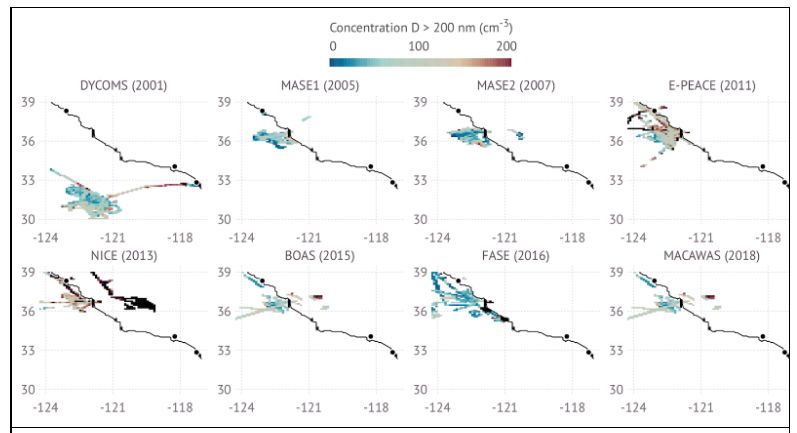
LM Russell et al., June 2021, DOE/SC-ARM-21-009

          Acronyms and Abbreviations
ACAPEX     ARM Cloud Aerosol Precipitation Experiment
ACCP       Aerosol, Cloud, Convection and Precipitation
ACE-2      Aerosol Characterization Experiment-2
ACE-ENA    Aerosol and Cloud Experiments in the Eastern North Atlantic
ACI        aerosol-cloud interactions
ACSM       aerosol chemical speciation mass spectrometer
AERI       atmospheric emitted radiance interferometer
AEROMMA    Atmospheric Emissions and Reactions Observed from Megacities to
           Marine Areas
AERONET    Aerosol Robotic Network
AETH       aethelometer
AMF        ARM Mobile Facility
AOS        Aerosol Observing System
AOSMET     automated weather station
APS        aerodynamic particle sizer
ARM        Atmospheric Radiation Measurement
ARSCL      Active Remote Sensing of Clouds Value-Added Product
ASR        Atmospheric System Research
AWARE      ARM West Antarctica Radiation Experiment
BNL        Brookhaven National Laboratory
BOAS       Biological and Oceanic Atmospheric Study
CAP-MBL    Clouds, Aerosol, and Precipitation in the Marine Boundary Layer
CCN        cloud condensation nuclei; cloud condensation nuclei particle counter
CEIL       ceilometer
CIRPAS     Center for Interdisciplinary Remotely Piloted Aircraft Studies
CN         condensation nuclei
CO         carbon monoxide, nitrous oxide, and water monitor
CPCF       condensation particle counter, fine
CPCU       condensation particle counter, ultrafine
CSPHOT     CIMEL sun photometer
CVI        counterflow virtual impactor
DL         Doppler lidar
DMS        dimethyl sulfide
DOE        U.S. Department of Energy
DSD        drop size distribution

                                    iv
LM Russell et al., June 2021, DOE/SC-ARM-21-009
DYCOMS-II Dynamics and Chemistry Of Marine Stratocumulus-II
E3SM Energy Exascale Earth System Model
ECOR eddy correlation flux measurement system
ENA Eastern North Atlantic
EPCAPE Eastern Pacific Cloud Aerosol Precipitation Experiment
E-PEACE Eastern Pacific Emitted Aerosol Cloud Experiment
FASE Fog and Stratocumulus Evolution Experiment
FTIR Fourier-transform infrared spectroscopy
GCSS GEWEX Cloud System Study
GEWEX Global Energy and Water Experiment
GNDRAD ground radiometer
GOES Geostationary Operational Environmental Satellite
GPCI GCSS Pacific Cross-Section Intercomparison
HSRHI hemispherical sky range-height indicator
HTDMA humidified tandem differential mobility analyzer
INTERPSONDE Interpolated Sonde Value-Added Product
IOP intensive operational period
KASACR Ka-Band Scanning ARM Cloud Radar
KAZR KA-band ARM Zenith Radar
LA/LB Los Angeles/Long Beach
LANL Los Alamos National Laboratory
LASIC Layered Atlantic Smoke Interactions with Clouds
LDIS laser disdrometer
LDQUANTS Laser Disdrometer Quantities Value-Added Product
LES large-eddy simulation
LWP liquid water path
MACAWS Marine Aerosol Cloud and Wildfire Study
MAGIC Marine ARM GPCI Investigation of Clouds
MASE Marine Stratus Experiment
MASRAD Marine Stratus Radiation Aerosol and Drizzle
MBL marine boundary layer
MFR multifilter radiometer
MFRSR multifilter rotating shadowband radiometer
MFRSRCLDOD Cloud Optical Properties from MFRSR Using Min Algorithm Value-
Added Product
MICROBASEEN Microbase Ensemble Data Products
MICROBASEKAPLUS Improved MICROBASE Product with Uncertainties Value-Added Product
MPL micropulse lidar
vLM Russell et al., June 2021, DOE/SC-ARM-21-009
MWR microwave radiometer
MWR3C 3-channel microwave radiometer
MWRRET Microwave Radiometer Retrievals Value-Added Product
NAAMES North Atlantic Aerosols and Marine Ecosystems Study
NASA National Aeronautics and Space Administration
NEPH nephelometer
NICE Nucleation in California Experiment
NIR near-infrared
NOAA National Oceanic and Atmospheric Administration
NSA North Slope of Alaska
NSF National Science Foundation
NWP numerical weather prediction
O3 ozone monitor
OACOMP Organic Aerosol Component Value-Added Product
ORG optical rain gauge
PCASP passive cavity aerosol spectrometer probe
PI principal investigator
PMF positive matrix factorization
PNNL Pacific Northwest National Laboratory
PPI plan position indicator
PSAP particle soot absorption photometer
PWD present weather detector
PWV precipitable water vapor
RHI range-height indicator
RRM reginal refined model
R/V research vessel
RWP radar wind profiler
SACR Scanning ARM Cloud Radar
SatCORPS Satellite ClOud and Radiation Property retrieval System
SCM single-column model
SEBS surface energy balance system
SKYRAD sky radiometer
SMPS scanning mobility particle sizer
SO2 sulfur dioxide monitor
SOLEDAD Stratocumulus Observations of Los Angeles Emissions-Derived Aerosol
Droplets
SONDE balloon-borne sounding system
SP2 single-particle soot photometer
viLM Russell et al., June 2021, DOE/SC-ARM-21-009
TBRG tipping bucket rain gauge
TCAP Two-Column Aerosol Project
TKE total kinetic energy
TSI total sky imager
UCSD University of California, San Diego
UHSAS ultra-high-sensitivity aerosol spectrometer
VAP value-added product
VARANAL Constrained Variational Analysis Value-Added Product
VDIS 2D video disdrometer
VDISQUANTS Video Disdrometer Quantities Value-Added Product
VIPR Vapor In-Cloud Profiling Radar
VPT vertically pointing profile
WAIS West Antarctic Ice Sheet
WB weighing bucket rain gauge
XRF X-ray fluorescence
viiLM Russell et al., June 2021, DOE/SC-ARM-21-009
Contents
Executive Summary ..................................................................................................................................... iii
Acronyms and Abbreviations ...................................................................................................................... iv
1.0 Background........................................................................................................................................... 1
2.0 Scientific Objectives ............................................................................................................................. 3
3.0 Measurement Strategies ........................................................................................................................ 4
3.1 Intensive Operational Periods ...................................................................................................... 6
4.0 Project Management and Execution ..................................................................................................... 6
4.1 Instruments ................................................................................................................................... 8
4.2 VAPS Requested ........................................................................................................................ 11
4.3 Collaborative Measurements ...................................................................................................... 11
4.4 Data Management Plan .............................................................................................................. 14
5.0 Science ................................................................................................................................................ 14
5.1 Scientific Focus .......................................................................................................................... 19
5.1.1 Q1—Cloud and Aerosol Climatology: What are the seasonal and diurnal cycles
of marine stratocumulus cloud and aerosol properties on the northeastern Pacific
coast? ............................................................................................................................... 20
5.1.2 Q2—Cloud Radiative Fluxes: How do cloud properties, including the ratio of
direct to diffuse radiation, change as coastal clouds are advected inland?...................... 22
5.1.3 Q3—Aerosol-Cloud Interactions (ACI): Will retrieved cloud properties (drop
size and number) reflect the regional signatures of aerosol? .......................................... 25
6.0 Relevancy to the DOE Mission .......................................................................................................... 28
7.0 References .......................................................................................................................................... 28
Figures
1 Map of Southern California coast showing locations of La Jolla and the ports of Los Angeles and
Long Beach (LA/LB). ............................................................................................................................ 1
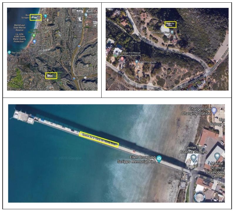
2 Overview (top left) of Scripps sites in La Jolla, California, with enlarged details for Mt. Soledad
(top right) and pier (bottom). .................................................................................................................. 5
3 Russell instrumentation van deployed at Mt. Soledad in 2012 with droplet probes sampling in
cloud (top left); Lubin spectroradiometer at Siple Dome Field Camp, Antarctica, in 2020 (top
right); Environment Canada Brechtel CVI (bottom left) and Chang fog drop monitor (bottom
right) deployed at Halifax, Canada, in 2016......................................................................................... 13
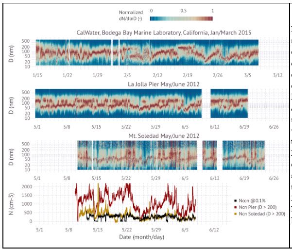
4 Observed aerosol number concentration for particle diameters >200 nm during various eastern
Pacific field campaigns......................................................................................................................... 19
5 Aerosol number size distributions and concentrations observed during the SOLEDAD campaign
in La Jolla in May-June 2012. .............................................................................................................. 21
viiiLM Russell et al., June 2021, DOE/SC-ARM-21-009
Tables
1 EPCAPE investigators and their roles. ................................................................................................... 3
2 ARM instruments requested (all are part of AMF1 except for *). ......................................................... 7
3 List of similar marine stratocumulus field campaigns in the Northern Hemisphere
(*plus LASIC). ..................................................................................................................................... 15
ixLM Russell et al., June 2021, DOE/SC-ARM-21-009
1.0 Background
Coastal cities provide the opportunity to characterize marine clouds and the substantial effects of
manmade particles on cloud properties and processes. La Jolla lies to the north of San Diego, California,
but given the frequent northwesterlies, it is often about a day directly downwind of the major and nearly
continuous pollution sources (S Liu et al. 2011) located in the ports of Los Angeles and Long Beach
(LA/LB, Figure 1). Since much of the distance between LA/LB and La Jolla is over ocean, sampling at La
Jolla provides snapshots of aerosol-cloud interactions (ACI) between marine stratocumulus and manmade
aerosol particles (Sanchez et al. 2016). The large dynamic range of concentrations of aerosol particles
combined with the multi-hour to multi-day persistence of stratocumulus cloud layers makes the site ideal
for investigating quantitative relationships between cloud properties and aerosols.
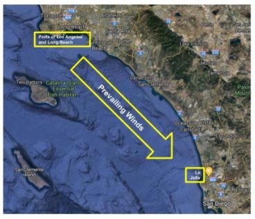
Figure 1. Map of Southern California coast showing locations of La Jolla and the ports of Los Angeles
and Long Beach (LA/LB). The direction of typical prevailing winds is also illustrated,
showing the frequent transport path of pollutants to La Jolla. The transit time of the port
emissions to La Jolla is typically 12 to 36 hr (Hawkins and Russell,2010, S Liu et al. 2011).
Modeling studies have shown substantial uncertainties and sensitivities to natural marine cloud
condensation nuclei (CCN) sources (Burrows et al. 2018, McCoy et al. 2015, SL Wang et al. 2018),
meaning that to reduce uncertainties in indirect effects we must be able to better quantify the marine CCN
budget at background and urban-influenced conditions (Lohmann and Feichter 2005, Twomey 1977).
While models provide important constraints on these uncertainties, actually quantifying their magnitude
requires substantial observations in multiple open-ocean and coastal regions in order to characterize the
variety of cloud properties and the variety of aerosol sources (Sanchez et al. 2018, 2017a, 2016).
The northeastern Pacific Ocean is home to one of the most persistent stratocumulus cloud layers in the
world, with consistent surface cooling provided by ocean upwelling and with the influence of
climatological subsidence on boundary-layer structure. The characteristics of these clouds are unique in
1LM Russell et al., June 2021, DOE/SC-ARM-21-009
many ways. For example, the northeastern Pacific features a broad area with high cloud droplet number
concentration (Bennartz and Rausch 2017), suggesting active aerosol-cloud interactions. In addition,
satellite evidence indicates that the northeastern Pacific stratocumulus cloud decks in the subtropical
region are most susceptible to changes in their outgoing shortwave radiation due to changes in cloud
microphysics (Painemal 2018). Previous studies conducted in Northern California suggested that the
shallowness of the MBL coupled with extremely strong overhead inversions near the coastline produce
near adiabatic cloud liquid water contents, which are efficient at implementing the first aerosol indirect
effect (Kim et al. 2012). While multilayer clouds can occur in this region (Muelmenstaedt et al.
unpublished results), the decoupling processes and residual layers associated with North Atlantic and
Southern Ocean features have not been frequently observed (Durkee et al. 2000, Stevens et al. 2003).
Drizzle formation is an important process that can deform these layers by producing pockets of clear air
surrounded by clouds known as open cells (Petters et al. 2006, Stevens et al. 2005, Wood 2007), but there
is little information about drizzle fluxes in these regions given the small amount of precipitation involved.
These features and knowledge gaps motivate the need to characterize the seasonal changes in marine
stratocumulus properties over the northeastern Pacific.
The northeastern Pacific Ocean borders a region with perhaps more measurements of aerosol than any
other region on the planet (California) but there is little analysis of coastal influences of marine sources
because the focus of the existing pollution monitoring sites has been on local air quality, which typically
targets urban centers. In addition, long-term measurements needed for a climatological characterization of
cloud and drizzle properties are scarce over the region. One aspect that makes La Jolla such a unique
observing site for aerosol particles is its location downwind of a large and relatively continuous pollution
source (S Liu et al. 2011). The distance between the LA/LB sources and La Jolla provides an effective
averaging time, allowing both mixing and reactions of pollutants (Figure 1). The resulting mixture is
more representative of the aerosol that is found a few hours downwind of global megacities, which today
covers much of the planet. The reason this feature is important for ACI is that the dependence of cloud
properties on aerosol in such conditions may be different from those of the more canonical ship tracks is
the presence of continuous sources that may effectively “saturate” clouds providing a different
environment than the relatively narrow and confined plumes of ship tracks. While plumes may be
continuously diluted by entrainment of adjoining clean air, polluted air masses may extend widely so that
large areas do not have clean air accessible at the scale of boundary-layer eddies.
The site for the EPCAPE campaign will be the Scripps Pier, with a few instruments (including the
Scanning ARM Cloud Radar [SACR]) at Mt. Soledad. The project will measure from February 2023
through January 2024. There is room for six first ARM Mobile Facility (AMF1) vans on the north side of
the Scripps Pier, which is a secure location with programmable key card access. The Aerosol Observing
System (AOS) van is expected to be located at the end of the pier between the existing instrument sheds.
Power will be provided to the vans by an agreement between UCSD and ARM. Permission from Scripps
has been obtained, pending agreement on location logistics, power upgrades, and Coastal Commission
approval. The requested AMF1 instruments that are to be located at the Soledad site are the SACR, laser
disdrometer (LDIS), and 2-channel microwave radiometer (MWR). Standard operating procedures are
requested for radar (vertically pointing profile [VPT], hemispherical sky range-height indicator [HSRHI],
and plan position indicator [PPI] in the case of SACR, if available) and other instrumentation.
The project includes investigators from both universities and national laboratories (Table 1). Four
investigators (Burrows, Muelmenstaedt, Wang, Aiken) represent three different DOE laboratories (Pacific
Northwest National Laboratory [PNNL], Los Alamos National Laboratory [LANL], Brookhaven National
2LM Russell et al., June 2021, DOE/SC-ARM-21-009
Laboratory [BNL]) and have current funded work related to the scientific questions raised here. Four
investigators (Fridlind, Ackerman, Lebsock, Painemal, Witte) are working at National Aeronautics and
Space Administration (NASA) laboratories and also have current projects related to these questions. All
expect that their analyses of the proposed observations will enhance their expected future
laboratory-based projects.
Table 1. EPCAPE investigators and their roles.
Investigator Defined EPCAPE Role
Russell Overall coordination and analysis; providing and analyzing aerosol filters.
Lubin Analysis and interpretation of AERI and related radiometric measurements.
Eloranta Coordination and analysis of lidar measurements.
Silber Analysis and interpretation of radar and lidar data; modeling of cloud formation.
Aiken Interpretation of ACSM and related aerosol properties.
Wang Interpretation of precipitation and drizzle properties.
Petters Analysis and interpretation of CCN and HTDMA measurements.
Muelmenstaedt Observationally constrained E3SM cloud modeling.
Burrows Comparisons of E3SM aerosol model simulations to observations.
Miller Analysis and interpretation of cloud structure and radiative properties.
Chang Providing and analyzing fog drop spectrometer.
Interpretation of gas-phase measurements and providing ground counterflow virtual impactor
Liggio
(CVI).
Wheeler Interpretation of ground CVI measurements.
Ackerman Evaluation and improvement of ModelE3 aerosol and stratiform cloud fields.
Fridlind Observation-based aerosol-aware case studies for LES and ModelE3 SCM.
Witte Analysis of microphysics-turbulence interactions in observations, LES, E3SM.
Lebsock Comparison of retrieved cloud properties to satellite and model products.
Painemal Interpreting satellite products from GOES-17 to support observations.
*Aiken and Wang also serve ARM roles as site operations staff (Aiken) and instrument mentor (Wang),
for which they are responsible for instrument operation and uncertainty characterization. As part of this
project, their roles are scientific interpretation of the results in the context of the other measurements as
part of work that is not funded by ARM.
2.0 Scientific Objectives
The focus of this project is to characterize the extent, radiative properties, aerosol interactions, and
precipitation of stratocumulus clouds in the Eastern Pacific across all four seasons at a coastal location,
the Scripps Pier and the Mt. Soledad sites in La Jolla, California. An important enhancement to this study
will be the collection of simultaneous in-cloud aerosol and droplet measurements to investigate the
3LM Russell et al., June 2021, DOE/SC-ARM-21-009
differences in these cloud properties during regional polluted and clean marine conditions. The combined
observations will provide an unprecedented set of constraints for the following questions:
1. Cloud and Aerosol Climatology: What are the seasonal and diurnal cycles of marine stratocumulus
cloud and aerosol properties on the northeastern Pacific coast?
2. Cloud Radiative Fluxes: How do cloud properties, including the ratio of direct-to-diffuse radiation,
change as coastal clouds are advected inland?
3. Aerosol-Cloud Interactions: Will retrieved cloud properties reflect the regional signatures of aerosol?
Each of these questions reflects a topic of current controversy in the literature that cannot be addressed
without the type of comprehensive data set proposed here. The discussion below illustrates some of the
large variety of scientific questions that are embedded in each of these three topics, allowing a rich
scientific landscape for investigations with this data set.
3.0 Measurement Strategies
The campaign plan will be to locate most of the AMF1 instrumentation at the main site at Scripps Pier
and a few additional instruments at the Scripps Mt. Soledad site (Figure 2), which will expand the short
deployment in 2012 to include the much more comprehensive suite of cloud and aerosol measurements
that is possible with AMF1. Below-cloud instrumentation, including cloud, precipitation, radiation, and
aerosol instruments, will be situated on the Scripps Pier. These instruments are listed in section “6. ARM
Resources Required.” Additional instrumentation (scanning radar) will be located at the Mt. Soledad site,
located less than 2 km inland (250 m above sea level), which will allow for sampling downwind of the
pier below, in, and above clouds depending on conditions. Statistics are not available on how frequently
the Soledad location is below, in, and above cloud (other than the seasonally limited prior study), as that
will be an important outcome of this 12-month data set.
The general work plan is that ARM engineers, technicians, and instrument mentors will set up the
instrumentation at the start of the campaign and that the requested instrumentation will run continuously
until the end of the campaign. ARM technicians and instrument mentors will provide daily checks on
instrumentation according to the standard protocols. Some modifications may be needed to provide
sufficient power at the pier and Soledad sites, depending on the number of vans and power required for
each of them. Measurements will be collected 24 hr per day and 7 days per week in order to capture full
daily cycles of cloud formation and dissipation. Online instrumentation will be run using standard DOE
protocols, typically multiple measurements per hour, for consistency with ARM data sets worldwide. The
radar operations should be continuous throughout the campaign, if possible, due to the sparse, episodic,
yet very important role of storms in this dry region. Guest instrumentation will use protocols appropriate
to the expected conditions.
4LM Russell et al., June 2021, DOE/SC-ARM-21-009
Figure 2. Overview (top left) of Scripps sites in La Jolla, California, with enlarged details for Mt.
Soledad (top right) and pier (bottom).
The planned measurements will meet the proposed scientific objectives by using the comprehensive ARM
cloud measurement suite to provide an unprecedented characterization of the extent, thickness, and
precipitation of stratocumulus clouds in the northeastern Pacific across all four seasons at a coastal
location. In addition, the guest instrumentation will augment the ARM aerosol suite by providing
advanced instrumentation that can be operated long-term (12 months) because of easy access by UCSD
principal investigators (PIs) and collaborators.
Satellite observations (which may include EarthCare, and the A-Train/C-Train constellation) will be used
to generalize the AMF1 measurements to the broader region offshore of and in coastal southern California
and northern Baja California. GOES-17 retrievals (SatCORPS) provided by the NASA Langley Cloud
Group will be relevant for characterizing the cloud diurnal cycle at a regional scale for analyzing
synoptic-scale variability and for Lagrangian studies. In addition, the National Weather Service
NEXRAD radar (KNKX) at San Diego will provide an important baseline with which to complement
ARM radar measurements capacity. We also plan to get the radiative flux divergence across the cloud
layer by adding radiometers from the Lubin group at the mountain site.
5LM Russell et al., June 2021, DOE/SC-ARM-21-009
3.1 Intensive Operational Periods
There will be two intensive operational periods (IOPs): EPCAPE-Chem, focused on characterizing low
clouds and their chemistry at Mt Soledad, extending from April through June; and EPCAPE-Radiation,
characterizing higher clouds and their radiative properties extending from July through September. A
critical aspect of both EPCAPE IOPs is characterization of the diurnal cycle of coastal clouds. For this
reason, we require four sondes per day during the highest stratocumulus cloud frequency
(April–September) and two sondes per day during the remainder of the year (February−March;
October−January). Two sondes per day are necessary to characterize the annual cycle, and four sondes
per day are needed to provide the day/night and night/day transitions relevant to the cloudier months.
Two sondes per day are sufficient to characterize boundary-layer structure and mixing, which provides
basic seasonal statistics to characterize cloud structure. These sondes will be launched at local noon and
midnight to show the differences between daytime and nighttime cloud structure. The two additional
sondes, at approximately 6am and 6pm local time, are required to characterize the transitions, which are
driven by the changes in surface heating associated with sunrise and sunset. The uncertainties of the
prevalent but poorly understood diurnal cycle of stratocumulus clouds is well known
(Duynkerke and Hignett 1993, Hignett 1991) and is amply illustrated by the Marine Stratus Radiation
Aerosol and Drizzle (MASRAD) data set.
Vertical profiles at sunrise have been shown to be of critical importance to prediction of inland solar
power predictions (E Wu et al. 2020a, 2019, Zapata et al. 2020, 2019). Drizzle evaporation can lead to
decoupling as the marine boundary layer (MBL) deepens and cloud-top radiative cooling is no longer able
to maintain a well-mixed MBL. Synoptic events could cause MBL depth to fluctuate enough to cause
decoupling that is not driven by the diurnal cycle. In fact, there could be instances in which the cloud type
is more in transition mode, such as shallow cumuli rising into stratocumulus. Thus, the need to document
the general decoupling state, which is intimately linked to the cloud structure, is a powerful justification
for additional soundings.
4.0 Project Management and Execution
The resources that will be needed from ARM for this campaign are AMF1, including standard
meteorological instrumentation, a broadband and spectral radiometer suite, and remote-sensing
measurements including lidars and radars, plus the AOS system for aerosol observations. AMF1 is well
suited for this deployment. Specific AMF1 instrumentation included as part of this proposal are listed in
Table 2.
6LM Russell et al., June 2021, DOE/SC-ARM-21-009
Table 2. ARM instruments requested (all are part of AMF1 except for *).
Lidars
MPL: micropulse lidar
DL: Doppler lidar
CEIL: ceilometer
Radars
KAZR: Ka-band zenith cloud radar
RWP: radar wind profiler
KASACR: Ka-band Scanning ARM Cloud Radar
Precipitation
VDIS: 2D video disdrometer
LDIS: laser disdrometer
ORG: optical rain gauge
PWD: present weather detector
TBRG: tipping bucket precipitation gauge
WB: weighing bucket precipitation gauge
Radiometers
MWR3C: 3-channel microwave radiometer
MWR: 2-channel microwave radiometer
SKYRAD: sky radiometer
GNDRAD: ground radiometer
MWR: microwave radiometer
AERI: atmospheric emitted radiance interferometer
MFRSR: multifilter rotating shadowband radiometer
CSPHOT: CIMEL sun photometer
MFR: multifilter radiometer
Atmospheric and boundary state
SEBS: surface energy balance
ECOR: eddy correlation flux
SONDE: balloon-borne sounding system (4/d for IOPs, otherwise 2/d)
TSI: total sky imager
AOSMET: automated weather station
Aerosol and trace gas systems
SMPS: scanning mobility particle sizer
CCN: cloud condensation nuclei counter
UHSAS: ultra-high-sensitivity aerosol spectrometer
7LM Russell et al., June 2021, DOE/SC-ARM-21-009
APS*: aerodynamic particle sizer
SP2*: single-particle soot photometer
HTDMA: humidified tandem differential mobility analyzer
ACSM: aerosol chemical speciation mass spectrometer
NEPH (dry, wet): nephelometers at dry and ambient relative humidity
CPCF: condensation particle counter, fine
CPCU: condensation particle counter, ultrafine
AETH: aethelometer
PSAP: particle soot absorption photometer
O3: ozone monitor
SO2: sulfur dioxide monitor
CO: carbon monoxide, nitrous oxide, and water monitor
*ARM instrument that is not currently available as part of AMF1 but it is requested to be added if it
becomes available because it would enhance the scientific objectives of this project.
4.1 Instruments
Lidars. DL will measure drizzle and air motion velocities that can be combined with the radar Doppler
velocity measurements in order to separate drizzle fall velocities from air motion. DL is critical for total
kinetic energy (TKE) and vertical profiling, providing important constraints for sub-cloud turbulence. DL
is also important for thermodynamic decoupling even if not fully decoupled. MPL provides cloud base
height, some aerosol profile information, and information about cloud profile close to cloud base. Aerosol
information retrieved by the MPL is based on backscatter ratio assumptions; CEIL provides cloud base
height with a first range gate at 11 m. Either CEIL or MPL is required for all MWR, AERI, and Active
Remote Sensing of Clouds Value-Added Product (ARSCL VAP) retrievals. High-spectral-resolution lidar
(HSRL) systems would reduce the assumptions required for retrievals and will be requested by Eloranta
from other funding sources (Eloranta 2005).
Radars. The KAZR provides the full vertical structure of clouds from a few hundred meters above
ground level up to the tropopause at vertical and temporal resolutions of 30 m and 2 s, respectively
(Riihimaki et al. 2017). The operation at the Ka-band enables the detection of both intense and light
precipitation for Q1 and Q3 (Silber et al. 2019) as well as relatively small hydrometeors (such as larger
cloud droplets [Verlinde et al. 2013]), while the KAZR Doppler capabilities allow the examination of
cloud microphysical composition and processes (Q1, Q3), as well as dissipation rate estimates for Q2
(Chen et al. 2018). Finally, the use of radar reflectivity and power-law parameterizations and the
synergistic use of the KAZR and lidar measurements enable the retrieval of precipitation rate for Q1 and
Q3. These features and instrument characteristics provide an essential component for the characterization
of clouds from both macro- and microphysical perspectives, which is crucial for the objectives of the
proposed studies. The radar wind profiler (RWP) is a Doppler radar that measures the horizontal wind
profile and turbulence intensity every 6 min up to an altitude of ~5 km in all weather conditions. Its
vertical beam can be used to study precipitation and vertical velocity of large hydrometeors in cloud.
8LM Russell et al., June 2021, DOE/SC-ARM-21-009
KASACR will be deployed at Mt. Soledad to allow better characterization of horizontal cloud and
precipitation structure, with a potentially extensive data set and with a significantly higher sensitivity than
precipitation radars (NEXRAD). KASACR will be used to quantify the cloud and sub-cloud drizzle
evolution from the pier to Mt. Soledad (in VPT mode) and would provide valuable information about the
spatial structure of cloud fields (for Q1, Q2, Q3; in PPI and HSRHI scan strategies [Kollias et al. 2014]).
The EPCAPE deployment of the KASACR at the Mt. Soledad site enhances our ability to answer Q1
(climatology of cloud properties) and Q2 (land surface influence on clouds). The deployment at
Mt. Soledad would enable an almost 360° coverage of the cloud and precipitation fields surrounding the
central site. The KASACR provides significantly higher sensitivity relative to the WSR-88D (NEXRAD)
network, allowing the detection of some tenuous cloud layers as well as the evaluation and spatial
characterization of light precipitation (drizzle) common to the Eastern Pacific (Comstock et al. 2004),
both upwind and downwind from the central AMF1 site at the pier. As the marine boundary layer moves
inland, mechanical mixing generated by the abrupt increase in surface roughness begins to influence and
eventually dominate the in-cloud mixing generated by cloud-top cooling and enhanced entrainment
(Ching et al. 2010). A key scientific focus is the evolution of the cloud dynamic and microphysical
structure as marine stratocumulus clouds transition to continental stratocumulus and cumulus clouds,
which should be observable with the KASACR from Mt. Soledad.
We need to understand these transitions because many ARM sites (AMF and fixed) are in coastal regions,
although the scientific objective was to measure marine clouds, namely MASRAD, Two-Column Aerosol
Project (TCAP), Layered Atlantic Smoke Interactions with Clouds (LASIC), North Slope of Alaska
(NSA), and Eastern North Atlantic (ENA). Knowledge of potential modifications at coastlines could
assist in the interpretation of data from these and other deployments. Periodic sectorial range-height
indicator (RHI) scans when pointing at a narrow range of azimuths centered over the pier would enable
acquiring information about the three-dimensional mesoscale structure of some cloud systems
predominantly upwind from the central site. Hemispheric PPI scans at minimum elevation angle
(0.5° moving from south-west-north, for which Mt. Soledad serves as the highest topographic feature over
a range of several tens of kilometers) would allow the characterization of cloud cell structure and the
retrieval of precipitation rates over distances of a few tens of kilometers from the central site
(Lamer et al. 2019). The deployment at the elevated Mt. Soledad site would likely reduce ground clutter
impact on the measurements at such a minimal elevation angle. Periodic PPI scans at a few additional
elevation angles (above 3°) covering all azimuths (360°) would provide comprehensive snapshots of the
cloud field over altitudes of up to a few kilometers common to the region and would potentially inform
about the influence of land surfaces on the cloud microphysical structure. Finally, periodic VPT
measurements would enable cross-calibration of the KASACR with the AMF1 KAZR located at the
Scripps Pier, and add the ability to supplement the central site with a secondary set of advanced
cloud-base precipitation rates while using the zenith-pointing lidar measurements that will be performed
at the Mt. Soledad site (O'Connor et al. 2005).
Precipitation. VDIS, LDIS, WB, TBRG, and ORG will be used to collect measurements of precipitation
properties. Disdrometers will provide details about the drop size distribution and drop fall velocity. Rain
gauges will be used to collect measurements of rainfall rate and rainfall accumulation. These precipitation
measurements are crucial to monitoring the calibration of the collocated radar, providing observational
analyses on aerosol and precipitation related topics, and supporting model evaluation and development.
Multiple disdrometers and rain gauges will be used to compare precipitation at the pier and Soledad sites
to better characterize the effects of coastal orography on precipitation.
9LM Russell et al., June 2021, DOE/SC-ARM-21-009
Radiometers. MWR3C will provide the primary independent remote-sensing retrieval of cloud liquid
water path (LWP). This newer system operates in three channels, 28.3, 30, and 89 GHz, and with the
highest-frequency channel can retrieve LWP for optically thinner clouds than the earlier MWR. This
capability with optically thin clouds will be particularly useful in examining the life cycle of coastal
marine stratiform clouds and possible ACI. The 2-channel MWR, which operates at 28.3 and 31.4 GHz,
has a 27-year track record. Its installation at Mt. Soledad (together with CEIL) will allow the examination
of cloud LWP downwind (and inland) from the pier (where the MWR3C will be installed; Q1, Q2, Q3),
and will serve as the backup direct and robust retrieval of cloud LWP (Cadeddu et al. 2013). The
SKYRAD system comprises the essential set of broadband shortwave and longwave measurements using
upward-looking pyranometers and pyrgeometers. Our prior work has shown that these instruments'
radiometric calibration has sufficient quality that significant changes in cloud microphysical properties
can manifest in statistically significant responses in downwelling surface irradiances measured by
SKYRAD (Lubin and Vogelmann 2006). The GNDRAD system is the downward-looking equivalent of
SKYRAD, providing continuous monitoring of surface albedo and broadband emissivity (when combined
with SKYRAD). Spectral longwave zenith radiance measurements from AERI provide remote-sensing
retrievals of cloud droplet effective radius (Lubin and Vogelmann 2006, Rowe et al. 2019, Turner 2007,
Turner et al. 2007) and are therefore essential for ACI investigation. The MFRSR measures diffuse and
global downwelling hemispheric irradiance in six wavelength bands between 415 and 940 nm, which are
used to provide a high-quality cloud optical depth data product. The MFR is the six-channel spectrally
resolved equivalent of GNDRAD's shortwave component and provides measurements of surface albedo
that are useful for accurate radiative transfer simulations. The CSPHOT, which contains eight
10-nm-wide spectral channels (at 340, 380, 440, 500, 675, 870, 1020, and 1640 nm), is the primary
measurement of total column aerosol optical depth. Its zenith radiance scans can also provide a backup
source of cloud optical depth and effective droplet radius retrievals. For Q2, surface upwelling
measurements in both shortwave and longwave are necessary to study the relative significance of
opposing cloud effects: increasing albedo and decreasing longwave emission. In combination with other
data products, GNDRAD measurements would aid studies on how cloud properties can influence the
balance of opposing cloud effects. TSI observations would provide validation for irradiance-based cloud
coverage metrics, which are subject to the accuracy of clear-sky models that can misconstrue instances of
high clear-sky irradiance with cloud enhancement effects.
Atmospheric and Boundary State. Surface and vertical observations of meteorological parameters
(AOSMET, PWD, SONDE) will provide crucial information on the meteorological conditions during
sampling. SONDE measurements provide vertical profiles needed for model initialization and nudging.
Four per day are requested during the IOPs, including the first prior to sunrise to better support inland
solar forecasts. SEBS and ECOR provide rough retrievals of surface turbulent fluxes. The TSI records
fractional sky coverage by cloud cover and is essential for sorting and interpreting all radiation
measurements. For example, under overcast skies hemispheric irradiance measurements can be used to
retrieve cloud optical properties, while under broken cloud cover zenith radiances should be used. The
TSI also offers opportunities for image classification and resource prediction using deep neural networks,
a growing topic of research in solar forecasting (Q2).
Aerosol and Trace Gas. Measuring the dry aerosol number size distribution (SMPS, UHSAS) will be
critical to characterizing aerosol climatology (Q1) and to understanding the aerosol effect on cloud
microphysical and radiative properties (Q3). In addition, the particle hygroscopicity will provide direct
observations of the expected ability of those particles to activate (CCN) so that they can be compared to
10LM Russell et al., June 2021, DOE/SC-ARM-21-009
actual cloud properties. Additional measurements to characterize the physical and chemical properties of
the aerosol population will provide important insight on the source and potential for the particles to act as
cloud droplets (HTDMA, ACSM, NEPH [dry, wet], CPCF, CPCU) and provide insights into the causes
of model biases in predicted CCN. Instruments characterizing the age and anthropogenic influence of the
air mass are able to discern the relationships between aerosol properties and the emissions sources and in
situ atmospheric transformations impacting aerosol in the sampled air mass (AETH, PSAP, O3, SO2,
CO).
4.2 VAPS Requested
The following value-added products (VAPs) are requested for this project for the reasons noted:
• VARANAL (Constrained Variational Analysis) – provides output required for model forcing for LES
and other simulations.
• ARSCL (Active Remote Sensing of Clouds) – provides output required for cloud radar interpretation
and structure.
• MICROBASEEN (Microbase Ensemble Data Products), MICROBASEKAPLUS (Improved
MICROBASE Product with Uncertainties) – provides output required for cloud microphysics from
ARSCL; log-normal based retrieval. (PIs will also use AERI and other algorithms.)
• MFRSRCLDOD (Cloud Optical Properties from MFRSR Using Min Algorithm) – provides output
required for cloud optical depth products from MFRSR.
• MWRRET (Microwave Radiometer Retrievals) – provides output required to retrieve LWP and
precipitable water vapor from 2- and 3-channel retrievals (can be compared to AERI retrieval at the
low end of 50g/m2), both Illingworth and Turner versions.
• INTERPSONDE (Interpolated Sonde) – provides gridding of the SONDE measurements onto
standard grids for modeling by constraining and interpolating from multiple sensors.
• LDQUANTS (Laser Disdrometer Quantities) – provides drop size distributions (DSDs) and
associated rainfall rates/accumulation as those raindrops fall to the ground from laser disdrometer.
• VDISQUANTS (Video Disdrometer Quantities) – provides DSDs and associated rainfall
rates/accumulation as those raindrops fall to the ground from video disdrometer.
• OACOMP (Organic Aerosol Component) – provides source-related characterization of organic
components by positive matrix factorization (PMF) of the ACSM organic components.
We also request the products that are available from Satellite ClOud and Radiation Property retrieval
System (SatCORPS).
4.3 Collaborative Measurements
PI Russell will request DOE Atmospheric System Research (ASR) program support to enable science by
providing filter sampling at the Scripps Pier to complement the chemical analysis available from the
AMF1 ACSM. This sampling will be housed in an AMF1 AOS van at the pier and is being proposed
separately through the ARM approval process as an add-on measurement. The samples will be collected
11LM Russell et al., June 2021, DOE/SC-ARM-21-009
weekly by ARM staff, similar to the ARM West Antarctica Radiation Experiment (AWARE) deployment
(J Liu et al. 2018a, 2018b), and will provide refractory components including organics and sea salt. A
conditional sampling system will be designed by PI Russell to trigger cut-off of the filter pump during
local high-condensation-nuclei (CN) events so that filter samples are more representative of regional
background conditions rather than local activities.
Co-PIs Russell and Petters have requested National Science Foundation (NSF) support (in collaboration
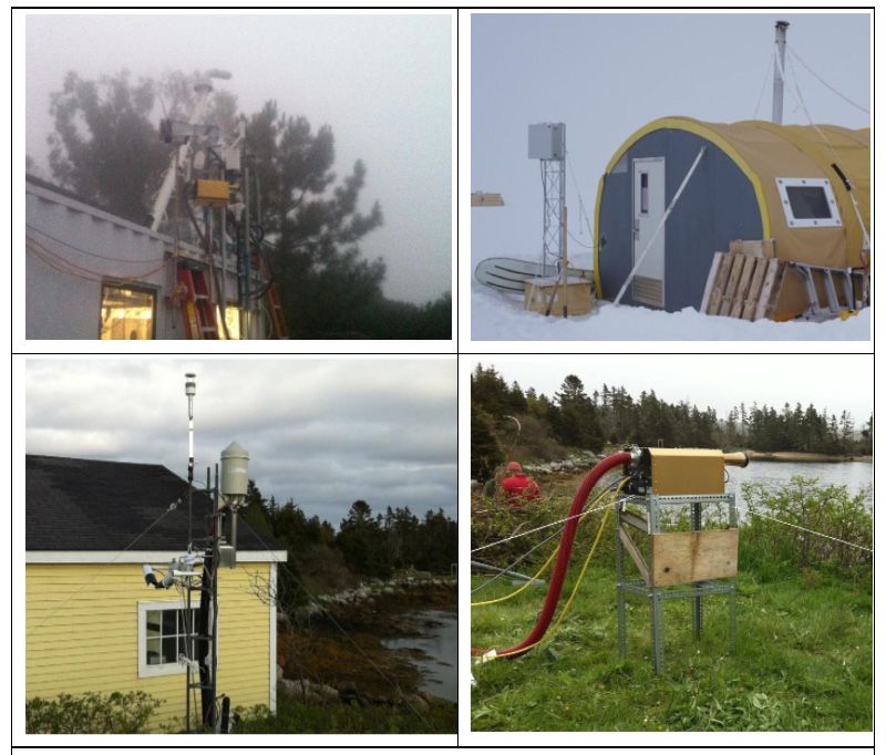
with Suzanne Paulson) to locate the Russell instrumentation van (Figure 3) for simultaneous deployment
at Mt. Soledad for in-cloud sampling of detailed aerosol chemical composition, including offline filter
analysis for organic functional groups (Fourier-transform infrared spectroscopy; FTIR) and elements
(X-ray fluorescence; XRF). The Russell van will also include SP2 and APS measurements, for
comparison to AMF1 AOS measurements at the Scripps Pier. The Russell van will include a high-
resolution, time-of-flight, event-enabled Aerodyne AMS to provide aerosol composition and
concentration aloft for comparison to the AOS ACSM deployed at the pier. Funding will also be
requested to deploy the fog droplet monitor from Co-PI Chang (Dalhousie) at this site to characterize the
droplet size distribution in cloud. Environment Canada expects to also provide a Brechtel ground-based
CVI (Figure 3) for deployment at the Mt. Soledad site to enable in-cloud composition sampling of droplet
residuals (Sanchez et al. 2016). Co-PI Liggio will request support to bring a chemical ionization mass
spectrometer, which previously demonstrated at Mt. Soledad that cloud water chemistry was likely
responsible for enhancements in low-molecular-weight polar organics such as isocyanic (HNCO) and
formic acids in cloud droplets, with scavenging efficiencies beyond what can be expected from Henry’s
Law solubility (Zhao et al. 2014). In situ aerosol measurements of interstitial aerosol and aerosol from
evaporated cloud droplets performed inside the cloud would strengthen the evidence required for
answering a number of questions raised in Q1 and Q3. These additional data sets would specifically
enhance Q3, as it will provide a substantial enhancement to the AMF1 instruments at a very minimal cost
given the proximity of the site to Scripps.
Co-PI Lubin will contribute a shortwave spectroradiometer of the type successfully deployed at the West
Antarctic Ice Sheet Divide (WAIS Divide) with AWARE (Wilson et al. 2018) and more recently at Siple
Dome Field Camp in West Antarctica during December 2019 to January 2020. Measurement of
shortwave spectral irradiance between 350 and1700 nm complements the mid-infrared AERI radiance
measurements, in that cloud optical properties (optical depth and effective radius) can be retrieved under
thicker clouds that emit in the longwave as blackbodies (with no spectral sensitivity to microphysics). The
related algorithms make use of the sensitivity in the 1.6-micron window to phase and effective droplet or
particle size, combined with optical depth-dependent attenuation at shorter conservative-scattering
wavelengths. In Antarctica, Lubin was successful with a straightforward algorithm based on
McBride et al. (2011) and was able to discern microphysical contrasts between climatologically typical
summer stratiform clouds and clouds in a considerably warmer air mass that caused surface melt
(Nicolas et al. 2017, Wilson et al. 2018). More advanced algorithms are available that use irradiance
throughout much of the shortwave spectrum to reduce retrieval uncertainties (LeBlanc et al. 2015). The
combination of this shortwave instrument with AERI will provide robust spectroscopic retrieval of cloud
microphysical properties over a wide range in cloud LWP, suitable for ACI studies. The current
instrument is manufactured by StellarNet (Inc.), and comprises a pair of miniature spectrometers
(visible-wavelength and near-infrared [NIR]) coupled using fiber optical cables to a radiometric diffusing
cosine collector. These components are enclosed in a small weatherproof housing with a small footprint
that can easily be accommodated on the roof of the AMF or similar structure. Power requirements are
12LM Russell et al., June 2021, DOE/SC-ARM-21-009
minimal (at Siple Dome this spectroradiometer was solar powered; Figure 3). For this project, it is
preferable to co-locate it with the MPL, which can provide independent verification of cloud phase via
lidar depolarization.
Figure 3. Russell instrumentation van deployed at Mt. Soledad in 2012 with droplet probes sampling in
cloud (top left); Lubin spectroradiometer at Siple Dome Field Camp, Antarctica, in 2020 (top
right); Environment Canada Brechtel CVI (bottom left) and Chang fog drop monitor (bottom
right) deployed at Halifax, Canada, in 2016.
Co-PI Eloranta plans to propose deployment of his HSRL with NSF support. Co-PI Witte will request
flight time for the Naval Postgraduate School (formerly Center for Interdisciplinary Remotely Piloted
Aircraft Studies; CIRPAS) Twin Otter aircraft for a 4-6 week IOP during the months of maximum low
cloud cover (March-July). Flights will be designed to sample aerosol, microphysics, and meteorological
state upwind of the Scripps Pier. The Twin Otter will also be equipped to measure surface fluxes over the
ocean that can be used to inform Lagrangian modeling studies of air masses arriving at the ground-based
measurement sites.
National Oceanic and Atmospheric Administration (NOAA) investigators (Patrick Veres and Drew
Rollins) are considering the possibility of collocating the Atmospheric Emissions and Reactions Observed
from Megacities to Marine Areas (AEROMMA) campaign (Warneke et al. 2021) near La Jolla in June
2023. AEROMMA plans to make airborne measurements of marine cloud chemistry in the EPCAPE
region in June 2023. Their focus will be investigating the implications of the recent discovery of a new
13LM Russell et al., June 2021, DOE/SC-ARM-21-009
dimethyl sulfide (DMS) oxidation product in the atmosphere (Veres et al. 2020). NASA ER-2
investigators may also be interested in scheduling overpasses for Aerosol, Cloud, Convection and
Precipitation (ACCP) suborbital measurements.
Multi-frequency radar methods are routinely used to derive precipitation drop sizes. However, they are
fundamentally limited at the low end by radar frequency. Current operational radars operate below
100 GHz or ~3 mm wavelength. Higher-frequency radar operated in combination with the ARM W- and
Ka-band radars would permit more precise sizing into the drizzle regime of precipitation. Co-PI Lebsock
is coordinating with NASA to bring the experimental G-band VIPR (Vapor In-Cloud Profiling Radar),
which operates at 175 GHz, during the April-June IOP. Coordinated observations with the KAZR or
SACR will demonstrate for the first time the possibilities for these advanced microphysical retrievals in
drizzling stratocumulus regimes.
4.4 Data Management Plan
The investigators have a long, established record of collaboration and data sharing with other
investigators on multi-investigator projects similar to EPCAPE, including past DOE ARM deployments
such as AWARE, MASRAD, and others. Observations and simulations by the Russell group that were
funded by federal and state grants have been posted to UCSD digital archives (Frossard et al. 2017a, b,
J Liu et al.,2018b, 2017, Modini et al. 2017, Russell et al. 2016, 2017, 2018, Saliba et al. 2019,
Sanchez et al. 2017b, 2017c, Takahama and Russell 2016). Any individual or composite data sets that
may be generated as a result of the analysis conducted for this project will be made available to the
scientific community on request. Project participants will archive and make available on request all
analysis products from observations used for the publications that result from this project. Specifically,
guest instruments in the Russell or AMF vans will be expected to also post their measurements within a
year of completion of the project. New code developed as part of this project will be made available to
DOE and others on request if not posted as part of the digital archives. Compilation of these data and
corresponding results will be advertised through regular presentations at scientific conferences and
through peer-reviewed journal publications.
Data Archives. Data resulting from this project will be published and made openly available to the
research community and the public through several sites. Publications and presentations resulting from
this award will properly reference the ARM Data Center as the source of data used in this research.
Additional publications, archives, and products will depend on both data availability and the outcome of
data analysis proposed as part of this project.
Publication. We will comply with the open-access data policy in accordance with DOE regulations. All
data resulting from this project will be published and made openly available to the research community
and the public through several mechanisms: (1) PI products will be archived and made available as part of
the ARM website; (2) PI products and associated analysis will be stored on the curated UCSD digital
archives; (3) Publications using results of this project will include links to the available data.
5.0 Science
Three DOE campaigns have been mounted in northeastern Pacific cloud regions (MASRAD, MAGIC,
ACAPEX), and in the Atlantic (where clouds have some similar characteristics) there is the ARM ENA
observatory and two additional field campaigns have occurred (Aerosol and Cloud Experiments in the
14You can also read