Enhancing Motorway Operation Services - M50 Traffic Flow Optimisation M50 Resilience between M50 J6 and J7: N3 to N4 Link May 2019 - Transport ...
←
→
Page content transcription
If your browser does not render page correctly, please read the page content below
enhancing Motorway Operation Services

M50 Traffic Flow Optimisation

M50 Resilience between M50 J6 and J7: N3 to N4 Link

May 2019
Roughan & O’Donovan – AECOM Alliance                                          TII - enhancing Motorway Operation Services
Consulting Engineers                                                                M50 Resilience between M50 J6 and J7

                          enhancing Motorway Operations Services

                     M50 Resilience between M50 J6 and J7

                                              Scoping Study

                                                   May 2019

 Document No: ....................................... 17.118 TO1722

 Author: .................................................. Elisa Longo (EL) / Colm Gogan (CG)

 Checker: ................................................ Seamus MacGearailt (SMG)

 Approver: .............................................. Seamus MacGearailt (SMG)

    Version            Description                       Made         Checked          Approved             Date
        A                      Draft                       EL            SMG               SMG          10/12/2018
        B                      Final                                                        TII         31/05/2019

 Ref: 17.118.10 TO1722                                  May 2019                                                  Page 1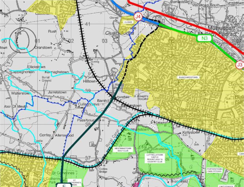
Roughan & O’Donovan – AECOM Alliance                                                          TII - enhancing Motorway Operation Services
Consulting Engineers                                                                                M50 Resilience between M50 J6 and J7

                                  enhancing Motorway Operation Services

                       M50 Resilience between M50 J6 and J7

                                                     Scoping Study

                                                            May 2019
 TABLE OF CONTENTS

 1.     INTRODUCTION ............................................................................................... 4
        1.1     Purpose of this Report ........................................................................................................ 4
        1.2     The need for M50 Diversion Routes ................................................................................... 4
 2.     EXISTING ORBITAL ROUTES BETWEEN M50 JUNCTION 6 AND 7............. 5
        2.1     Route 1: Castleknock and Chapelizod East of M50 ........................................................... 5
        2.2     Route 2: R121 - N3 J3 at Blanchardstown to N4 J4 at Lucan ............................................ 5
        2.3     Route 3: R149 & Laraghcon Link - N3 J4 at Clonee to N4 J4 at Lucan ............................. 5
        2.4     Route 4: R149 – M3 J4 at Clonee to N4 J5 at Leixlip or M4 J6 at Leixlip West ................. 6
        2.5     Route 5: R157 - M3 J5 at Dunboyne to M4 J7 at Maynooth .............................................. 6
        2.6     Summary of the Existing Alternative Routes ...................................................................... 7
 3.     CONSTRAINTS ............................................................................................... 10
        3.1     Environmental ................................................................................................................... 10
        3.2     Topography....................................................................................................................... 14
        3.3     Recreational Sites............................................................................................................. 16
        3.4     Royal Canal and Sligo Railway Line................................................................................. 16
        3.5     Existing Urban Areas ........................................................................................................ 17
        3.6     Commercial / Industrial Sites ............................................................................................ 17
        3.7     Major Road Links to Northeast & Southwest .................................................................... 17
        3.8     Existing Junctions on N3/M3 & N4/M4 ............................................................................. 18
 4.     POTENTIAL NEW LINK ROUTES .................................................................. 20
        4.1     Route A: N3 J3 Blanchardstown to N4 J2 Liffey Valley via Porterstown.......................... 20
        4.2     Route B: N3 J3 Blanchardstown to N4 J3 Ballydowd via Porterstown............................. 21
        4.3     Route C: N3 J4 Castaheany to N4 J3 Ballydowd via Lutrellstown ................................... 22
        4.4     Route D: N3 J4 Castaheany to N4 J3 Ballydowd via Westmanstown ............................. 23
        4.5     Route E: N3 J4 Castaheany to N4 J5 Leixlip ................................................................... 24
        4.6     Route F: N3 J4 Castaheany to N4 J5 Leixlip ................................................................... 25
        4.7     Route G: M3 J4 Clonee to N4 J5 Leixlip .......................................................................... 26
        4.8     Route H: M3 J5 Dunboyne to M4 J5 Leixlip ..................................................................... 27
        4.9     Route I: M3 J5 Dunboyne to M4 J6 Celbridge ................................................................. 28
        4.10 Route J: M3 J5 Dunboyne to M4 J7 Maynooth ................................................................ 29
        4.11 Route K: M3 J5 Dunboyne to Potential New M4 J7A Maynooth West............................. 29
        4.12 Summary Table of the Diversion Routes .......................................................................... 31
 5.     POLICY REVIEW & WIDER DEMAND FOR TRAVEL ................................... 32
        5.1     Policy Review ................................................................................................................... 32

 Ref: 17.118.10 TO1722                                            May 2019                                                                 Page 2
Roughan & O’Donovan – AECOM Alliance                                                       TII - enhancing Motorway Operation Services
Consulting Engineers                                                                             M50 Resilience between M50 J6 and J7

        5.2    Public Transport Links ...................................................................................................... 34
        5.3    Demand for orbital travel west of the M50 ........................................................................ 34
 6.     SUMMARY & CONCLUSIONS ....................................................................... 36

 APPENDIX A                 STUDY AREA AND CONSTRAINTS MAP

 Ref: 17.118.10 TO1722                                          May 2019                                                              Page 3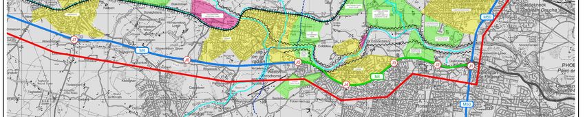
Roughan & O’Donovan – AECOM Alliance TII - enhancing Motorway Operation Services
Consulting Engineers M50 Resilience between M50 J6 and J7
1. INTRODUCTION
1.1 Purpose of this Report
Transport Infrastructure Ireland (TII) has recently developed a comprehensive diversion route network
for the M50 Motorway ring road around Dublin. Occasional motorway closures arise due to major
incidents. A coherent diversion route strategy is necessary as part of a traffic management regime under
the motorway operations system. These measures are currently in place around most of the M50, with
the exception of the West Link Bridge crossing of the River Liffey valley between Junction 6
Blanchardstown on the N3 radial route and Junction 7 Palmerstown on the N4 radial route.
This report, outlines the need for improved alternatives to the M50, discusses the existing alternative
orbital routes between Junctions 6 and 7 on the M50 and proposes options that could be considered as
part of wider orbital transport network improvements in Dublin.
1.2 The need for M50 Diversion Routes
In 2015 an Interagency Incident Coordination Group (IICG) for the M50 was established to provide a
forum for communication between key stakeholders in relation to co-ordination of resources and
incident management on the M50. In addition, the IICG can be convened in the event of a major incident
so that the decision makers from each agency can coordinate a combined multiagency response. The
agencies involved in the IICG include:
An Garda Síochána;
Dublin Fire Brigade;
The four Dublin Local Authorities;
TII; and
The Motorway Traffic Control Centre.
One of the first initiatives by the IICG was the identification of the need for emergency diversion routes
to provide alternative routes to traffic in the case of an M50 closure. The majority of these routes have
been implemented and signs are now in place on all available routes between the M1 (Junction 3) and
Junction 12 on the M50 with the exception of the section between the N3 (Junction 6) and the N4
(Junction 7). Signage for the section between Junction 12 on M50 and Junction 17 (M11) is scheduled
for completion by Dun Laoghaire Rathdown County Council in Q3 2019.
There remains a need to for an adequate diversion route between the N3 and N4.
In 2018, there were a total of 1,164 recorded incidents on the M50 of which 541 were traffic collisions.
The wider network impacts of major incidents on the M50 are severe. The resulting delays on the wider
transport network last much longer than the actual incident duration.
Ref: 17.118.10 TO1722 May 2019 Page 4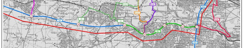
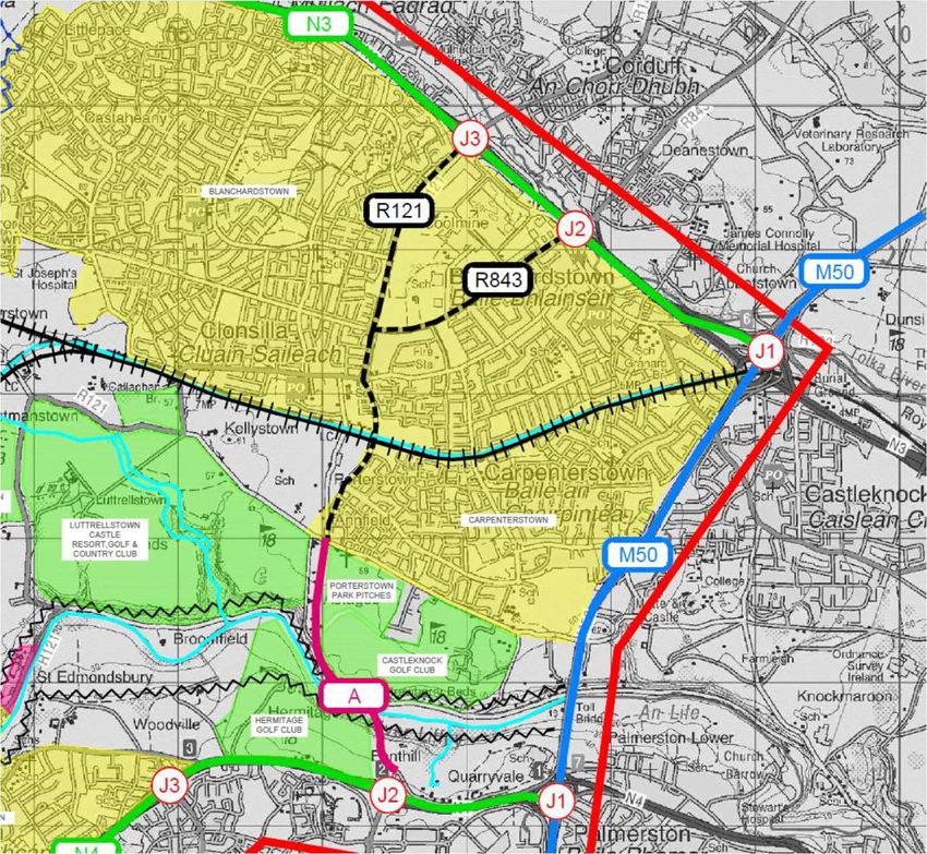
Roughan & O’Donovan – AECOM Alliance                                   TII - enhancing Motorway Operation Services
Consulting Engineers                                                         M50 Resilience between M50 J6 and J7

 2.       Existing Orbital Routes between M50 Junction 6 and 7
 2.1      Route 1: Castleknock and Chapelizod East of M50
 There is only one possible diversion route east of the M50 that does not traverse the city centre, due to
 the required crossing of the Liffey and also the location of the Phoenix Park. The L-3100 College Road
 / Tower Road skirts around the western side of the park and passes through the villages of Castleknock
 and Chapelizod via the steep and narrow Knockmaroon Hill as shown on Figure 1.

 This route is 7.65 Km long, compared to 3km along the M50. At Knockmaroon Hill the road is less than
 6m wide with a gradient in excess of 7% and as a result there is a 3.5 Tonne weight restriction. At
 Chapelizod just north of where this route crosses the River Liffey there is a very sharp turn with an angle
 in excess of 120 degrees that is difficult for all traffic. These deficiencies mean that this is route is not
 considered suitable as a diversion route for the M50.

 2.2      Route 2: R121 - N3 J3 at Blanchardstown to N4 J4 at Lucan
 West of the M50, the first existing regional route connecting the N3 to the N4 is the R121 that links
 Blanchardstown to the village of Lucan via Clonsilla and Westmanstown as shown on Figure 1. This
 diversion route is 14 Km long of which 9.6 Km is off the N3 and N4 national routes.

 Initially on Blanchardstown Road South this route has a 12m carriageway, with a lane for cars and a
 dedicated lane for busses in each direction. It narrows progressively from North to South, reaching a
 minimum width of 6m in the rural area south of Clonsilla with no provisions for cyclists or footpaths in
 places.

 In plan, the road geometry is irregular, with numerous sharp bends in different places that restrict
 visibility for drivers. The most severe bend is where the route descends steeply to the junction with the
 Strawberry Beds Road, which is located on a very sharp hairpin bend as shown in the following
 photograph. There is a 3 Tonne limit on the route at this point.

 The other major constraint along this route is at the railway level crossing and narrow bridge over the
 Royal Canal at Clonsilla. This location and Clonsilla village are now effectively bypassed to the east as
 the main traffic flow is directed further along Luttrellstown Road to a relatively new bridge over the
 railway and canal at Porterstown.

 At the southern end the R121 crosses the River Liffey at Lucan Bridge and passes through the centre
 of the village to the Newcastle Road that links to Junction 4 on the N4. The streets in Lucan are narrow
 and busy with regular local congestion. The Newcastle Road is narrow and winding. For all the above
 identified deficiencies this route is not satisfactory as a diversion route for the M50.

 2.3      Route 3: R149 & Laraghcon Link - N3 J4 at Clonee to N4 J4 at Lucan
 Route 3 as shown on Figure 1, is the next westward existing route linking Junction 4 of the N3 at Clonee
 to Junction 4 of the N4 at Lucan through two regional roads, R149 and R121, and a local road
 connection at Laraghcon that bypasses the hairpin junction on the R121 to connect to Lucan village
 from the north. This diversion route is 19.2 Km long of which 8.5 Km is off the N3 and N4 national
 routes.

 The diversion route includes a length of 5.2 Km along the R149, which has a 5.5m carriageway and a
 2m wide footpath in the Clonee area. The alignment is reasonably good but with a few sharp bends

 Ref: 17.118.10 TO1722                             May 2019                                                Page 5
Roughan & O’Donovan – AECOM Alliance                                  TII - enhancing Motorway Operation Services
Consulting Engineers                                                        M50 Resilience between M50 J6 and J7

 including two at junctions. Unlike for the R121 to the east, on the Laraghcon Link that branches off the
 R149 to the northwest of Lucan, this route crosses the Royal Canal and railway at Collins Bridge without
 a level crossing. This route avoids some of the most severe constraints of the R121 north of the River
 Liffey, but it is not a suitable diversion route for traffic from the M50.

 2.4      Route 4: R149 – M3 J4 at Clonee to N4 J5 at Leixlip or M4 J6 at Leixlip
          West
 The northern section of Route 4, as shown on Figure 1, is the same as for Route 3, but it avoids Lucan
 Village to the west and passes either through Leixlip Village instead to Junction 5 or continues further
 west to reach the M4 at Junction 6 via the three regional roads R149, R148 and R449. These diversion
 routes are, proceeding east to west 22.5 and 29.2 Km long of which 12.5 Km to 16.4 Km is off the N3
 and N4 national routes.

 At the northern edge of Leixlip, the R149 makes a sharp turn at the junction beside Confey Bridge that
 spans over the Royal Canal and Dublin-Sligo Railway line. The bridge is too narrow for two-way traffic
 and there is a traffic signal shuttle that severely constrains the traffic capacity with resultant frequent
 queuing.

 The R149 joins the R148 in Leixlip Village where there are further severe traffic capacity constraints
 and several right-angled turns at the junction on the Main Street and at either end of the River Liffey
 Salmon Leap Bridge.

 The alternative route to the west of Leixlip bypasses the bottleneck at Confey Bridge but the southbound
 traffic queue can back up to block the next junction just 120m to the north. This longer route follows
 local road towards Collinstown around the northern side of the major Intel factory via Kellystown Lane
 (L1014), which is a very narrow rural road that includes a single-track bridge over the River Rye that
 greatly restricts traffic capacity.

 At Collinstown this route joins the R148, former N4 Galway Road to link back eastward for 1km in front
 of the Intel factory complex. It then joins the R449 dual carriageway link towards the M4 at Junction 6,
 which has high traffic capacity and a good road alignment. Overall, while the R149 can provide a
 moderately good traffic route for most of the length, the difficulties in the Leixlip area preclude it from
 being a suitable diversion route for the M50.

 2.5      Route 5: R157 - M3 J5 at Dunboyne to M4 J7 at Maynooth
 Route 5 as shown on Figure 1 is the fifth and last possible alternative route that links from Junction 5 of
 the M3 at Dunboyne to Junction 7 of the M4 at Maynooth via the three regional roads R157, R148 and
 R406.

 This diversion route is 38.9 Km long of which 14.7 Km is off the N3 and N4 national routes.

 From M3 Junction 5 the initial 3km length of the R157 forms a western bypass of Dunboyne and has
 an unusually wide 10m single carriageway cross section with hard shoulders and an overall carriageway
 width of 16m.

 Southwest of Dunboyne the R157 is a more typical 6 to 6.5m wide with numerous sharp bends with
 restricted visibility, including 3 right-angled turns at junctions such as the one below where the route
 turns to skirt the boundary of the Carton Estate near Maynooth.

 Ref: 17.118.10 TO1722                            May 2019                                                Page 6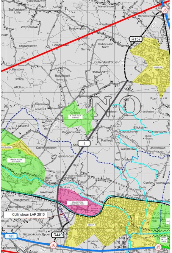
Roughan & O’Donovan – AECOM Alliance                                    TII - enhancing Motorway Operation Services
Consulting Engineers                                                          M50 Resilience between M50 J6 and J7

 For this route to reach Junction 7 on the M4 involves crossing through Maynooth town centre where
 there is regular traffic congestion which is a critical constraint for diverting the traffic away from the M50.
 In 2018 design has commenced for the Maynooth Eastern Relief Road which will bypass the constraints
 in the town centre. Thus the R157 could become a reasonably suitable alternative route for some traffic
 that might otherwise use the M50 to get around the edge of Dublin. However at a distance of 14 Km
 west of the M50 it is too far out to be of much use for diversion of traffic away from the orbital motorway,
 except in the most extreme circumstances and for very limited volumes of traffic.

 2.6      Summary of the Existing Alternative Routes
 All the mentioned constraints, lengths and several advantages and disadvantages discussed have been
 summarised in Table 1. The colour code reflects the map included in Figure 1 overleaf.

 A review of the existing road network within a range extending for 3 Km east of the M50 and 14 Km
 westward has considered 5 possible existing alternative routes. The review has found that that 4 of the
 routes are unsuitable, and that the fifth and longest diversion at Maynooth might have limited suitability
 once a new Eastern Relief Route is developed in the town.

 Therefore the West Link section of the M50 between the N3, Junction 6 and N4, Junction 7 is, and will
 remain, very vulnerable to major traffic disruption if closure is necessary in the absence of a suitable
 alternative route.

                                                                  Length of                    Length
                                                                                                            Total
                                                                     each                      of each
    Existing                       Relevant                                                                Length
                   Junction                         Regional       regional      National     national
   Alternative                   Geographical                                                                of
                    linked                           Roads           road         Roads         road
      Route                         Areas                                                                  Route
                                                                  sections                    sections
                                                                                                            [km]
                                                                     [km]                       [km]

                  J1 of the      Castleknock
                                                      Local
     Route 1      N3 - J1 of    and Chapelizod                       7.6           N/A           N/A         7.6
                                                      Road
                   the N4        East of M50

                  J3 of the     Blanchardstown                                      N3           2.5
     Route 2      N3 - J4 of       -Clonsilla -       R121           8.7                                     15.9
                   the N4            Lucan                                          N4           4.7

                                                      R149           5.2
                  J4 of the                                                         M3           5.9
                                                      Local
     Route 3      M3 - J4 of    Clonee - Lucan                       2.1                                     19.2
                                                      Road
                   the N4
                                                      R121           1.2            N4           4.7

                                                      R149           8.5            M3           5.9
                  J4 of the
                                    Clonee -
    Route 4A      M3 - J5 of                                                                                 22.5
                                    Weston            R148           1.5            M4           6.6
                   the M4

 Ref: 17.118.10 TO1722                              May 2019                                                Page 7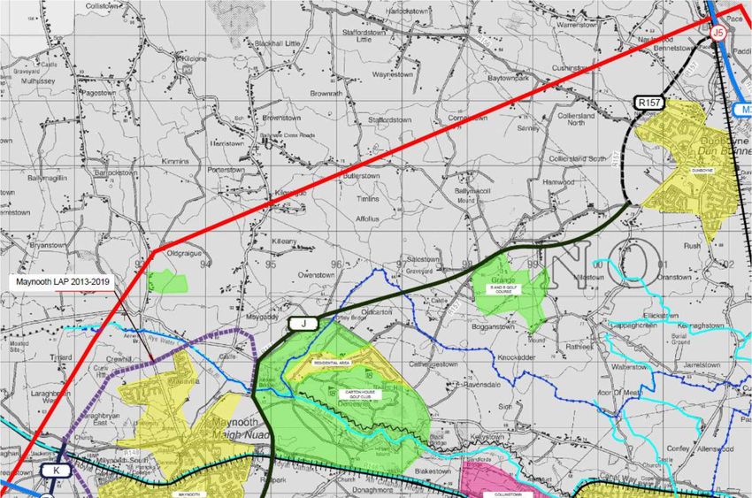
Roughan & O’Donovan – AECOM Alliance                               TII - enhancing Motorway Operation Services
Consulting Engineers                                                     M50 Resilience between M50 J6 and J7

                                                              Length of                   Length
                                                                                                       Total
                                                                 each                     of each
    Existing                       Relevant                                                           Length
                   Junction                        Regional    regional     National     national
   Alternative                   Geographical                                                           of
                    linked                          Roads        road        Roads         road
      Route                         Areas                                                             Route
                                                              sections                   sections
                                                                                                       [km]
                                                                 [km]                      [km]

                                                     R149        8.5
                  J4 of the                                                    M3           5.9
    Route 4B      M3 - J6 of    Clonee - Leixlip     R148        2.5                                    29.2
                   the M4
                                                     R449        1.7           M4          10.5

                                                     R157       11.9
                  J5 of the       Duboyne -                                    M3           9.6
     Route 5      M3 - J7 of      Maynooth -         R148        1.3                                    38.9
                   the M4          Carton
                                                     R406        1.6           M4          14.5

                    Table 1 - Summary Table of the Existing Alternative Routes lengths

 Ref: 17.118.10 TO1722                             May 2019                                            Page 8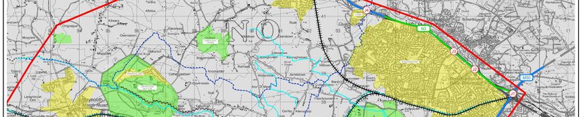
Roughan & O’Donovan – AECOM Alliance                                           TII - enhancing Motorway Operation Services
Consulting Engineers                                                                  M50 Resilience between M50 J6 and J7

                                       Figure 1: Existing Alternative Routes

 Ref: 17.118.10 TO1722                               May 2019                                                      Page 9
Roughan & O’Donovan – AECOM Alliance TII - enhancing Motorway Operation Services
Consulting Engineers M50 Resilience between M50 J6 and J7
3. CONSTRAINTS
The constraints found in the study area informed the identification of a number of possible options for
new orbital routes between the N3 and N4 corridors. The types of constraints identified have been
included in the Study Area & Constraints Map in Appendix A.
3.1 Environmental
3.1.1 Environmental Background
The study area extends west of the M50 for 14 Km to Maynooth, and includes a range of places of
environmental interest. The institution responsible in Ireland for the protection of habitats and species
and many other environmental issues is The National Parks and Wildlife Service. The NPWS is part of
the Heritage Division of the Department of Arts, Heritage, Regional, Rural and Gaeltacht Affairs and its
role is:
To secure the conservation of a representative range of ecosystems to maintain and enhance
populations of flora and fauna in Ireland.
To designate and advise on the protection of habitats and species identified for nature
conservation (Natural Heritage Areas (NHA), Special Areas of Conservation (SAC) and Special
Protection Areas (SPA) having particular regard to the need to consult with interested parties.
To make the necessary arrangements for the implementation of National and EU legislation
and policies for nature conservation and biodiversity including the EU Habitats and Birds
Directives, and for the ratification and implementation of the range of international Conventions
and Agreements relating to the natural heritage.
To manage, maintain and develop State-owned National Parks and Nature Reserves.
To promote awareness of natural heritage and biodiversity issues through education, outreach
to schools and engaging with stakeholders.
Conserving species in their natural habitats requires a strategic approach to succeed. One of these is
to ensure the adequate conservation of habitats where many of the plants and animals live.
The NPWS distinguishes the Protected Sites into three main categories:
Natural Heritage Areas (NHA)
Special Areas of Conservation (SAC)
Special Protection Areas (SPA)
The basic designation for wildlife is the Natural Heritage Area (NHA). This is an area considered
important for the habitats present or which holds species of plants and animals whose habitat needs
protection. To date, 75 raised bogs have been given legal protection, covering some 23,000
hectares. These raised bogs are located mainly in the midlands. A further 73 blanket bogs, covering
37,000ha, mostly in western areas are also designated as NHAs.
The Special Areas for Conservation are prime wildlife conservation areas in the country, considered
to be important on a European as well as Irish level. Most Special Areas of Conservation (SACs)
are in the countryside, although a few sites reach into town or city landscapes, such as Dublin Bay
A Special Protection Area (SPA) is a designation under the European Union Directive on the
Conservation of Wild Birds. Under the Directive, Member States of the European Union (EU) have
a duty to safeguard the habitats of migratory birds and certain particularly threatened birds. Ireland
Ref: 17.118.10 TO1722 May 2019 Page 10Roughan & O’Donovan – AECOM Alliance TII - enhancing Motorway Operation Services
Consulting Engineers M50 Resilience between M50 J6 and J7
is required under the terms of the EU Birds Directive (2009/147/EC) to designate Special Protection
Areas (SPAs) for the protection of endangered species of wild birds,
Listed rare and vulnerable species such as those mentioned above.
Regularly occurring migratory species, such as ducks, geese and waders.
Wetlands, especially those of international importance, which attract large numbers of
migratory birds each year.
In Ireland, a programme to identify and designate SPA sites has been in place since 1985 and a
review of the Irish network of SPA sites had identified a number of sites that required re-notification.
3.1.2 Environmental constraints within the Study Area
Figure 2 - Special Areas of Conservation (SAC) in the Greater Dublin Area
Ref: 17.118.10 TO1722 May 2019 Page 11Roughan & O’Donovan – AECOM Alliance TII - enhancing Motorway Operation Services
Consulting Engineers M50 Resilience between M50 J6 and J7
Figure 3 - Natural Heritage Areas (NHA) in the Greater Dublin Area
River Liffey
The River Liffey between Dublin and Leixlip is not designated as either an SAC or an NHA.
Rye Water SAC
As shown in Figure 2 the only relevant Special Area for Conservation in the study area is the Rye Water
Valley/Carton SAC, shown in greater detail in Figure 4. This is located between Leixlip and Maynooth
on a small tributary to the River Liffey at Leixlip.
Ref: 17.118.10 TO1722 May 2019 Page 12Roughan & O’Donovan – AECOM Alliance TII - enhancing Motorway Operation Services
Consulting Engineers M50 Resilience between M50 J6 and J7
Figure 4 - Rye Water Special Areas of Conservation (SAC) west of Leixlip
Rye Water Valley/Carton SAC is located between Leixlip and Maynooth, in Counties Meath and Kildare,
and extends along the Rye Water, a tributary of the River Liffey. The site is a Special Area of
Conservation (SAC) selected for the following habitats and/or species listed on Annex I / II of the E.U.
Habitats Directive (* = priority; numbers in brackets are Natura 2000 codes):
[7220] Petrifying Springs
[1014] Narrow-mouthed Whorl Snail (Vertigo angustior)
[1016] Desmoulin's Whorl Snail (Vertigo moulinsiana)
The conservation importance of the site lies in the presence of several rare and threatened plant and
animal species, and the presence of petrifying springs, a habitat type listed on Annex I of the E.U.
Habitats Directive. The woods found on Carton Estate and their birdlife are of additional interest.
Ref: 17.118.10 TO1722 May 2019 Page 13Roughan & O’Donovan – AECOM Alliance TII - enhancing Motorway Operation Services
Consulting Engineers M50 Resilience between M50 J6 and J7
3.2 Topography
Within the boundary of the study area, the topography is generally homogenous and flat in the plain of
Dublin, Kildare and Meath. (Figure 5) The exceptions are a number of watercourses where the
differences in terms of elevation are variable and marked.
Figure 5 – Topography Map of the study area
3.2.1 River Liffey Valley
The Liffey forms a fairly deep valley that is about 50m deep below the surrounding terrain in the Lucan
area. This represents a major constraint in the identification of a link road between the N3 and the N4
as a diversion route for the M50. Where the valley is this deep there will be a need for a major bridge
such as the existing West Link Bridge (Figure 7 ) on the M50 which is 400m long on 40m high piers
spanning over the Strawberry Beds. Figure 6 shows the deep valley of the River Liffey in the Lucan
area with elevations varying from about 200 -150m OD at the highest points to an average of 50m OD
in the valley.
Ref: 17.118.10 TO1722 May 2019 Page 14Roughan & O’Donovan – AECOM Alliance TII - enhancing Motorway Operation Services
Consulting Engineers M50 Resilience between M50 J6 and J7
Figure 6 - Highest elevation differences around Lucan
Figure 7 - M50 West Link Bridge across the Liffey Valley at Strawberry Beds
3.2.2 Liffey Valley at Leixlip
West of Lucan the Liffey Valley is not as deep as further east, with a considerably lower level difference
of 25m at the eastern edge of Leixlip. The valley flattens out somewhat in this area and a new north-
south road link could cross the river on a low-level and reasonably short bridge.
Ref: 17.118.10 TO1722 May 2019 Page 15Roughan & O’Donovan – AECOM Alliance TII - enhancing Motorway Operation Services
Consulting Engineers M50 Resilience between M50 J6 and J7
3.2.3 Rye Water Valley
The Rye Water Valley cuts deeply into the terrain as it descends towards the River Liffey at Leixlip.
Figure 8 - Highest elevation differences around Collinstown / Leixlip
3.3 Recreational Sites
A number of recreational sites have been identified within the study area, such as parks, sport facilities
and resorts as follows and included in the Constraints Map:
Castleknock Golf Club
Hermitage Golf Club
Porterstown Park Pitches
Luttrellstown Castle Hotel & Golf Club
Westmanstown Golf Club
Lucan Golf Club
Liffey Valley Regional Park / St. Catherine's Park (Leixlip/Lucan)
Grange Golf Club (Bogganstown)
Carton House & Demesne
3.4 Royal Canal and Sligo Railway Line
The Royal Canal and Sligo Railway Line run parallel each other across the study area from
Blanchardstown westward to Leixlip, north of the River Liffey valley.
A new orbital road will need to cross the canal and railway with careful selection of suitable places for
a bridge. In some places there is a local or regional road along the canal bank, such as at the north-
western edge of Leixlip, which will complicate the provision of a new bridge for an orbital route.
In mid-2019 Kildare County Council has sought planning approval for the proposed Maynooth Eastern
Ring Road, which will have a bridge over the canal and railway at the eastern edge of the town to form
a new single carriageway road connecting from the M4 Junction 7 as far as the R157 Dunboyne Road.
Ref: 17.118.10 TO1722 May 2019 Page 16Roughan & O’Donovan – AECOM Alliance TII - enhancing Motorway Operation Services
Consulting Engineers M50 Resilience between M50 J6 and J7
3.5 Existing Urban Areas
Within the study area have been identified six major urban areas that may affect the design of a future
road link between the N3 and the N4: Blanchardstown, Lucan, Leixlip, Maynooth, Dunboyne and
Clonee.
All of these former villages have now grown into large suburban areas with populations of between
15,000 (Leixlip) and 120,000 (Blanchardstown). Provision of a suitable new road between these urban
areas that can connect through them to the N3 and N4 corridors is very constrained in terms of traffic
capacity and potential impacts on residential communities.
3.6 Commercial / Industrial Sites
There are two important commercial / industrial sites within the study area:
Liffey Valley at Lucan North
Intel at Collinstown, Leixlip
These sites can constrain the design of a route for a new orbital road link, and they should generally be
skirted where possible. An example for Collinstown is shown in Figure 9 where a northward extension
of the R449 is not feasible without demolition of buildings at the Intel campus.
Figure 9 - Intel Site and other facilities at Collinstown - Obstacle for Northward extension of the R449
3.7 Major Road Links to Northeast & Southwest
A relevant consideration is the potential for a new orbital route to connect with other similar orbital links
around the Dublin area, including:
N3 J4 Castaheany eastward to N2 J3 Cherryhound Link via Ballycoolin (Fingal);
Ref: 17.118.10 TO1722 May 2019 Page 17Roughan & O’Donovan – AECOM Alliance TII - enhancing Motorway Operation Services
Consulting Engineers M50 Resilience between M50 J6 and J7
R113 Fonthill Road from N4 J2 Liffey Valley southward to N7 J1a Newlands Cross (South
Dublin);
R136 from N4 J3 Ballydowd southward to N7 J2 Kingswood (South Dublin);
Proposed Link from N4 J5 Leixlip southward to N7 J4a at Rathcoole West (South Dublin).
3.8 Existing Junctions on N3/M3 & N4/M4
There are varying degrees of available traffic capacity at the existing junctions along the radial routes
that will be a factor in route selection. Some existing junctions have fairly small traffic capacity and may
be already overloaded. It is desirable that an M50 diversion route can cater for as large a volume of
traffic as possible and to avoid obvious bottlenecks.
Ref: 17.118.10 TO1722 May 2019 Page 18Roughan & O’Donovan – AECOM Alliance TII - enhancing Motorway Operation Services
Consulting Engineers M50 Resilience between M50 J6 and J7
Table 2: Review of existing junctions on N3/M3 and N4/M4
Junction Name Junction Type Comments
N3 J2 Snugborough Hybrid diamond junction with a 5-arm Capacity is limited and there is regular congestion, which indicates that this junction is not suitable for a
signal junction on the southern side diversion route from the M50.
at Blanchardstown Village.
N3 J3 Blanchardstown Diamond junction with the addition of Capacity is reasonably high, but so are traffic demands. This junction is suitable for connection to a new
a loop in one quadrant as part of orbital route linking southward to the N4.
recent major capacity enhancement.
N3 J4 East Two half-junctions on either side of Originally the layout on the eastern side was a dumbbell with a pair of roundabouts, but these were
Castaheany / Clonee the village connected by a pair of 1 replaced with signal junctions and a one-way northbound 3 lane link on the bridge for additional capacity.
Km long two-way link roads.
N3 J4 West Clonee Dumbbell roundabout layout Recently as part of the M3 Clonee to Kells PPP scheme the northbound merge ramp was relocated to
connect directly from the southern roundabout rather than from the Dunboyne Road junction as previously
arranged.
M3 J5 Dunboyne Full rotary junction The junction has very high traffic capacity and low demand. It also has a very high-quality link southward
along the R157 Dunboyne Western Bypass.
N4 J2 Liffey Valley Hybrid dumbbell junction with partial Located only 1 Km west of M50 Junction 7 and beside the very busy Liffey Valley shopping centre, which
signalisation causes considerable traffic pressure. The R113 orbital route links southward from here to the N7 that is
currently used for M50 diversions.
N4 J3 Ballydowd Hybrid diamond junction with traffic This junction was modestly upgraded as part of the Lucan Bypass Improvement Scheme through provision
(Lucan East) signals of an additional traffic lane on the bridge and a new footbridge on the eastern side. This junction serves
most of the eastern Lucan area which causes considerable traffic pressure.
N4 J4 Newcastle Road Diamond junction with traffic signals Upgraded as part of the Lucan Bypass Improvement Scheme.
(Lucan Central)
N4 J5 Leixlip East / Combination of a diamond and This is the junction identified by Fingal County Council for the southern terminus of a new orbital route
Lucan West dumbbell layout from Hansfield to Leixlip. It is also identified by South Dublin County Council for the northern end of a new
orbital route to extend southward to the N7 at Rathcoole.
M4 J6 Celbridge / High-capacity rotary junction Provides high-quality access for both the Intel factory to the north and the former HP plant to the southeast
Leixlip West (now closed) which had combined employment of about 6,000 people at one stage.
M4 J7 Maynooth Combination of a diamond and Main access junction for the town of Maynooth with a population of 15,000 people, therefore high demand
dumbbell layout for its use.
Ref: 17.118.10 TO1722 May 2019 Page 19Roughan & O’Donovan – AECOM Alliance TII - enhancing Motorway Operation Services
Consulting Engineers M50 Resilience between M50 J6 and J7
4. POTENTIAL NEW LINK ROUTES
Eleven routes have been considered, broadly accounting for the constraints identified in Section 3, that
have the potential to act as a diversion route to the M50 and therefore enhance its resilience between
Junctions 6 and 7.
4.1 Route A: N3 J3 Blanchardstown to N4 J2 Liffey Valley via Porterstown
From East to West, the first route option is Route A (Figure 10). It links Junction 3 of the N3 with Junction
2 of the N4. The total length of road section is 5.1 Km of which 3.3 Km is along existing roads at the
northern end (Blanchardstown Road South and Porterstown Link Road) with a new 1.8 Km link required
across the River Liffey valley to connect to the N4 at Junction 2.
Despite its proximity to the M50, which is consequently a benefit in terms of shorter diversion length,
there are a series of major constraints on this route: the crossing of the River Liffey, with very steep
gradients on each side of the valley, and busy traffic conditions in the urban area of Blanchardstown.
This corridor was previously identified for Metro West, which is no longer proposed as part of the Dublin
Regional Transport Strategy. To cross the 50m deep Liffey Valley on this route would be a major
challenge, which for Metro West was proposed to involve a high-level bridge similar in scale to the
existing 400m long West Link Bridge. This option will have traffic capacity limitations at N4 Junction 2,
which is already very busy due to the Liffey Valley Shopping Centre adjoining.
Figure 10: Route A
Ref: 17.118.10 TO1722 May 2019 Page 20Roughan & O’Donovan – AECOM Alliance TII - enhancing Motorway Operation Services
Consulting Engineers M50 Resilience between M50 J6 and J7
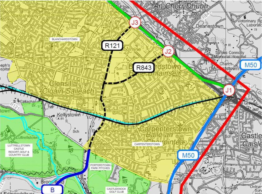
4.2 Route B: N3 J3 Blanchardstown to N4 J3 Ballydowd via Porterstown
The northern part of Route B (Figure 11) follows the same existing roads as Route A at the northern
end, but it links to N4 Junction 3 instead of junction 2. The constraints are mainly the same as for Route
A, but Route B has the additional advantage of linking Blanchardstown directly to the village of Lucan.
The total length of this route is 5.3 Km long, with 3.2 Km of which is along existing roads and 2.1 Km of
new road would be required.
This option will have traffic capacity limitations at N4 Junction 3, which is already busy due to the link
southward along the R136 road that provides an orbital route to the N7 at Junction 2 Kingswood. The
required bridge over the River Liffey for Option C would be similar to that for Options A and B.
Figure 11: Route B
Ref: 17.118.10 TO1722 May 2019 Page 21Roughan & O’Donovan – AECOM Alliance TII - enhancing Motorway Operation Services
Consulting Engineers M50 Resilience between M50 J6 and J7
4.3 Route C: N3 J4 Castaheany to N4 J3 Ballydowd via Lutrellstown
Route C links N3 Junction 4 with N4 Junction 3. It is 6.5 Km long, with 4.3 Km of new road required.
This route has mainly the same constraints as Route B: steep gradient in places, and a major bridge
crossing of the River Liffey. In addition, there will need to be a revised main road corridor through the
new urban area in the Hansfield SDZ, which has not been planned for to date. There would be 2 railway
crossings and a canal crossing as shown in Figure 12.
Figure 12: Route C
Route C would follow the existing R121 regional road corridor (Clonsilla to Lucan) over a length of 1.4
Km along the eastern boundary of the Westmanstown Sports Centre and Golf Club, which would entail
road widening and encroachment into the frontage properties. The required bridge over the River Liffey
for Option C would be similar to that for Options A and B.
Ref: 17.118.10 TO1722 May 2019 Page 22Roughan & O’Donovan – AECOM Alliance TII - enhancing Motorway Operation Services
Consulting Engineers M50 Resilience between M50 J6 and J7
4.4 Route D: N3 J4 Castaheany to N4 J3 Ballydowd via Westmanstown
Route D (Figure 13) is a variant of Route C which takes a longer way around the western side of
Westmanstown Gold Club and does not involve widening of the existing R121 Regional Road. The total
length of route is 7.5 Km, which is 1 Km longer than Route C, with 5.3 Km of new road. An advantage
of this route is that it avails of a road reservation across the Hansfield SDZ lands.
Figure 13: Route D
Ref: 17.118.10 TO1722 May 2019 Page 23Roughan & O’Donovan – AECOM Alliance TII - enhancing Motorway Operation Services
Consulting Engineers M50 Resilience between M50 J6 and J7
4.5 Route E: N3 J4 Castaheany to N4 J5 Leixlip
Route E (Figure 14) links junction 4 of the N3 with junction 5 of the N4 and generally follows the
indicative route as shown on the Fingal County Council Development Plan from Hansfield to east of
Leixlip. However, in the vicinity of Leixlip Route E stays entirely inside the Fingal County area and does
not extend over the county boundary into County Kildare.
Figure 14: Route E
This route would traverse through the middle of the Liffey Valley Regional Park (St. Catherine’s Park)
along the line of the county boundary. A route could potentially be provided that avoids the sports
pitches in the park, but may affect a small facility building, and a part of a car park. The proposed route
could be arranged such that the park activities can continue on either side with the use of ‘Green
Bridges’ and reduced level of carriageway.
At the northern bank of the River Liffey Route E would skirt around the Leixlip Wastewater Treatment
Plant on the eastern side. As the valley is less deep at this location the required road bridge over the
River Liffey for Option E would be at a lower level and shorter than for Options A to D. The terrain on
Ref: 17.118.10 TO1722 May 2019 Page 24Roughan & O’Donovan – AECOM Alliance TII - enhancing Motorway Operation Services
Consulting Engineers M50 Resilience between M50 J6 and J7
the approaches is less steep so that a new road can descend to enable a shorter span of less than
100m.
South of the River Liffey Route E would traverse across the northwest corner of the Liffey Valley Par 3
Golf Course, with some loss of effective space for the golf activity. In terms of traffic capacity, this route
is the same as Options C and D at the northern N3 end where it connects to Junction 4.
4.6 Route F: N3 J4 Castaheany to N4 J5 Leixlip
Route F (Figure 15) is very similar to Route E and directly represents the indicative route as proposed
by Fingal County Council in the Development Plan. Route F (Figure 51) is 6.8 Km long, of which 4.7
Km requires a new road link from Hansfield to Leixlip. It links Junction 4 East on the N3 with Junction 5
of the N4, and the constraints are largely the same as for Route E.
Figure 15: Route F
However, at Liffey Valley Park the route follows the western boundary within St. Catherine's Park
alongside the edge of a housing estate in Leixlip. It would also impact on several playing pitches in the
park. On the other hand, it avoids impacts on the utility building and car park that are affected by Option
E.
Ref: 17.118.10 TO1722 May 2019 Page 25Roughan & O’Donovan – AECOM Alliance TII - enhancing Motorway Operation Services
Consulting Engineers M50 Resilience between M50 J6 and J7
Route F skirts the wastewater treatment plant on the western side to cross the River Liffey upstream of
the Route E crossing point. Immediately to the northwest of the treatment plant the route would cut
across the corner of the grounds of the Liffey Valley Hotel in an area of woodland. On the southern side
of the river Route F then avoids the golf course and crosses agricultural land to connect to N4 Junction
5.
4.7 Route G: M3 J4 Clonee to N4 J5 Leixlip
Route G (Figure 16) links Junction 4 West of the M3 to Junction 5 of the N4. It avoids use of the Ongar
Road through a residential area and instead has a new road link within County Meath to connect to the
M3 west of Clonee village. The total length of new road is 7 Km. The constraints on Route G are mainly
the same of Route F in the Leixlip area.
Figure 16: Route G
Ref: 17.118.10 TO1722 May 2019 Page 26Roughan & O’Donovan – AECOM Alliance TII - enhancing Motorway Operation Services
Consulting Engineers M50 Resilience between M50 J6 and J7
4.8 Route H: M3 J5 Dunboyne to M4 J5 Leixlip
Route H (Figure 17) links Junction 5 of the M3 with Junction 5 of the M4. The overall length of the route
is 9.5 Km, of which the northern 2.5 Km is constituted by an existing road on the Dunboyne Western
Bypass. From the southern end of the bypass on the R157 it follows a green-field route over 5 Km
before converging with Routes F and G for the final 2 Km.
Figure 17: Route H
Ref: 17.118.10 TO1722 May 2019 Page 27Roughan & O’Donovan – AECOM Alliance TII - enhancing Motorway Operation Services
Consulting Engineers M50 Resilience between M50 J6 and J7
4.9 Route I: M3 J5 Dunboyne to M4 J6 Celbridge
Route I (Figure 18) links Junction 5 of the M3 at Dunboyne with Junction 6 of the M4 at Celbridge. The
length of the Route is 13.5 Km of which 10.4 Km is new road. There are few constraints along the route
which crosses agricultural land and avoids one golf course at Grange. The main constraint is the
crossing of the Rye Water Special Area for Conservation to the west of Leixlip, which will require a
careful design approach for a new bridge to avoid impacts. In any event an Environmental Impact
Assessment would be required for this option.
Figure 18: Route I
The southern part of the new route will link to the R449 dual carriageway at Collinstown by following a
new road reservation as proposed in Collinstown LAP 2010. It will require a bridge to cross over the
Royal Canal and Sligo Railway Line at this location.
Ref: 17.118.10 TO1722 May 2019 Page 28Roughan & O’Donovan – AECOM Alliance TII - enhancing Motorway Operation Services
Consulting Engineers M50 Resilience between M50 J6 and J7
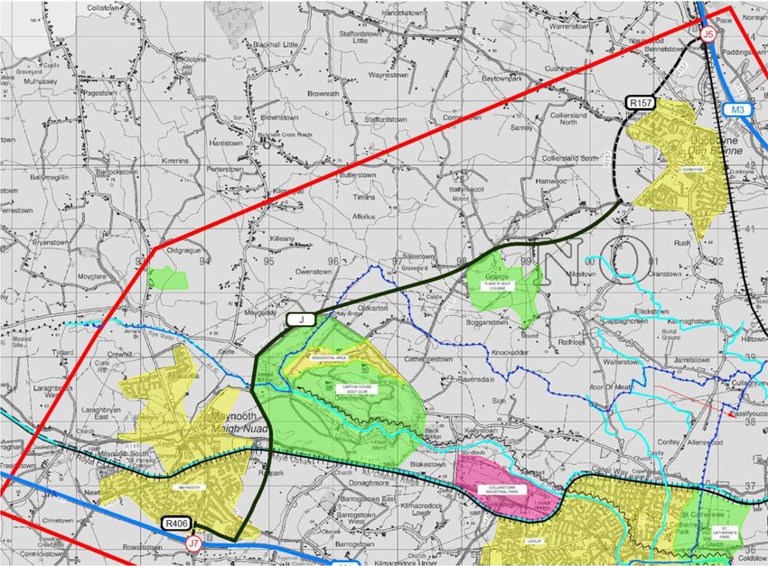
4.10 Route J: M3 J5 Dunboyne to M4 J7 Maynooth
Route J (Figure 19) links Junction 5 of the M3 with Junction 7 of the M4 and replaces the existing R157
regional road over a length of 13.5 Km long. It passes around the northern side of Carton Demesne at
the eastern side of Maynooth. There is an eastern ring road proposed around Maynooth that will then
cater for the route to skirt around the town and link to the M4 at Junction 7. Planning approval is
underway for this route, which should be completed within the next two years. On Route J the Rye
Water SAC is skirted around the western edge. Route J requires 7 Km of new road, apart from the
Maynooth Eastern Ring Road that is already separately funded.
Figure 19: Route J
4.11 Route K: M3 J5 Dunboyne to Potential New M4 J7A Maynooth West
Route K (Figure 20) is an alternative of Route J with a potential new Junction 7A on the M4 west of
Maynooth. Such a new junction could enable the completion of a ring road around Maynooth on the
western side of the town with a new junction to relieve traffic pressure on Junction 7. This would provide
a direct access route to Maynooth University as an alternative to the current route through the town
centre.
This option is 14.3 Km long, consisting of 2.5 Km of existing road at Dunboyne, 7 Km of new rural road
to replace the R157 for the connection to Maynooth, and 4.8 Km of ring road around the northern and
western sides of the town. Route K requires 12 Km of new road, including extension of the Maynooth
Ring Road.
Ref: 17.118.10 TO1722 May 2019 Page 29Roughan & O’Donovan – AECOM Alliance TII - enhancing Motorway Operation Services
Consulting Engineers M50 Resilience between M50 J6 and J7
Figure 20: Route K
Ref: 17.118.10 TO1722 May 2019 Page 30Roughan & O’Donovan – AECOM Alliance TII - enhancing Motorway Operation Services
Consulting Engineers M50 Resilience between M50 J6 and J7
4.12 Summary Table of the Diversion Routes
The lengths of the diversion route for each option are shown below in Table 3.
Table 3: Summary Comparison Table of the Diversion Route Options
Diversion Lengths (km)
Route Non-National National
Junctions linked Total New Road
Option Roads Roads
N3 J2 - N4 J2 4.2 3.1 2.8 1.8
A
N3 J3 - N4 J2 5.1 3.1 3.7 1.8
N3 J2 - N4 J3 6.2 3.1 4.4 2.1
B
N3 J3 - N4 J3 7.0 3.1 5.3 2.1
C N3 J4 - N4 J3 12.4 2.9 8.8 4.3
D N3 J4 - N4 J3 13.4 2.9 8.8 5.3
E N3 J4 - N4 J5 16.4 2.9 12.6 4.5
F N3 J4 - N4 J5 16.6 2.9 12.6 4.7
G N3 J4 - N4 J5 15.6 0.0 12.6 6.5
H M3 J5 - N4 J5 22.3 3.2 16.2 6.4
I M3 J5 - M4 J6 26.8 4.0 20.1 6.2
J M3 J5 - M4 J7 34.1 3.5 24.1 10.0
K M3 J5 - M4 J7a 37.9 3.2 26.5 11.6
Ref: 17.118.10 TO1722 May 2019 Page 31Roughan & O’Donovan – AECOM Alliance TII - enhancing Motorway Operation Services Consulting Engineers M50 Resilience between M50 J6 and J7 5. Policy Review & Wider Demand for Travel 5.1 Policy Review The need to enhance orbital transport accessibility in the Dublin Metropolitan Area, west of the M50 and between the N3 and N4 corridors is recognised in regional transport policy documents and various local authority development plans. The National Transport Authority Transport Strategy for the Greater Dublin Area 2016 – 2035 clearly refers to a future link between the N3 and N4 radial routes to be developed within to enhance orbital accessibility for all modes in this region of the Dublin Metropolitan Area. Objective OBJ MT43 of the Fingal Development Plan 2017-2023 is to “support and facilitate the TII, Meath County Council and Kildare County Council in the planning and delivery of the N2 upgrade north of Ashbourne and a possible link between the M3 and N4”. The relevant Map from the Fingal Development Plan is shown in Figure 21. This indicates a proposed road link at the south-western extremity of the county from the Ongar Road in the Hansfield area towards Leixlip and Junction 5 on the N4/M4. Ref: 17.118.10 TO1722 May 2019 Page 32
Roughan & O’Donovan – AECOM Alliance                                   TII - enhancing Motorway Operation Services
Consulting Engineers                                                          M50 Resilience between M50 J6 and J7

    Figure 21: Extract from Fingal Development Plan 2017-2023 zoning map indicating an N3-N4 link alignment

 The South Dublin County Council Development Plan 2016-2022 includes an objective (Table 6.6)
 for a “Western Dublin Orbital Route (north)” which is a new high capacity road from Tootenhill to the
 Leixlip Interchange (with a provision to make a further connection to the N3).

 The Kildare County Development Plan 2017-2023 (Table 6.1) refers to examining options; in
 consultation with South Dublin County Council, Fingal County Council, Meath County Council, TII and
 other statutory agencies for the delivery of an orbital link road from the M4 to the M3.

 Ref: 17.118.10 TO1722                             May 2019                                               Page 33
Roughan & O’Donovan – AECOM Alliance TII - enhancing Motorway Operation Services Consulting Engineers M50 Resilience between M50 J6 and J7 The Hansfield SDZ Planning Scheme (April 2006) outlines development proposals for the Hansfield Strategic Development zone at the south-western edge of the Greater Blanchardstown Area, immediately to the south of Ongar and west of Clonsilla. Under the future roads proposals in the SDZ a reservation has been facilitated within the lands to cater for a future road link to the N4. 5.2 Public Transport Links Linking between the N3 and N4 corridors by public transport is not an easy task due to very limited existing services. There is a railway corridor along the Dublin to Sligo line that provides an oblique connection between Leixlip and Blanchardstown, but this does not properly provide a north-south link between the main population centres of Blanchardstown on the northern side and Lucan/Clondalkin on the southern side, or Tallaght further south. The absence of a suitable local or regional road connection, apart from the M50 motorway, has precluded the provision of an orbital bus service to link the major suburbs west of the M50 that have a combined population of about 300,000 people. Such a service could reduce the existing very high car- dependency for such trips at present, which places additional traffic pressures on the M50. A few examples of possible trips using existing services have been considered and are included in Appendix B. The outcome of this analysis comparing car and public transport in terms of travel time shows remarkable differences with public transport trips that are 3 to 4.5 times more than those by cars. If a suitable north-south were provided this would enable new public transport services with accordingly reduced travel time differences that could encourage a modal shift away from car trips along the M50 with consequent benefits for traffic pressures on the motorway in normal conditions. 5.3 Demand for orbital travel west of the M50 The N4 & N7 Corridor Study, completed by TII and South Dublin County Council in February 2017, developed a coordinated plan for investment in road infrastructure to protect the strategic function of the National Roads, whilst supporting population and employment growth in the South Dublin area. As part of this study, a demand analysis of link between the N3 and N4 (as per the Fingal Development Plan alignment) was undertaken. The analysis found that the link, referred to in the study as the “Ongar Link Road Scheme”, would result in benefits to the strategic road network and particularly the M50. The Dublin Orbital Movement Study Options Report undertaken by the NTA in 2015 as part of the development of the Transport Strategy, identified a potential commuter trip demand in the region of 4,000 – 5,000 trips between the settlements of Blanchardstown and Tallaght, crossing the River Liffey. The demand analysis undertaken as part of the study noted that this substantial orbital demand indicated the potential for orbital public transport services. This is due to the significant employment and population centres on the corridors as shown in Figure 22 Ref: 17.118.10 TO1722 May 2019 Page 34
Roughan & O’Donovan – AECOM Alliance                                   TII - enhancing Motorway Operation Services
Consulting Engineers                                                         M50 Resilience between M50 J6 and J7

  Figure 22: Extract from Dublin Orbital Movement Study showing population / employment in Dublin settlements

 In summary, in addition to the policy objectives to provide enhanced orbital transport connectivity west
 of the M50, a number of technical studies have determined a substantial demand for these movements
 for travel by private and public transport.

 Ref: 17.118.10 TO1722                             May 2019                                               Page 35
Roughan & O’Donovan – AECOM Alliance                                 TII - enhancing Motorway Operation Services
Consulting Engineers                                                        M50 Resilience between M50 J6 and J7

 6.       Summary & Conclusions
 The need for an alternative diversion route for traffic between the N3 and N4 in Dublin to provide
 alternative routes for traffic in the case of an M50 closure was identified by the M50 Interagency Incident
 Coordination Group (IICG). Diversion routes have been identified for all other sections on M50 as part
 of measures to improve network resilience along the corridor. The existing alternatives to the M50 that
 cross the River Liffey have a combination of poor alignment, insufficient width, problematic junctions,
 excessive diversion lengths and other issues that make them unsuitable for an M50 diversion route.

 From a constraints study and options analysis, 11 no. potential route options were identified as having
 the potential to offer a satisfactory diversion route for M50 traffic between the N3 and N4.

 Regional and local transport policies support the need for the development of an orbital transport
 corridor west of the M50 in Dublin. This is supported by technical reports and demand analysis by TII
 and the NTA confirming the existing and future demand for such a route for both private car traffic and
 public transport. Therefore there is an opportunity to address the resilience of the M50 by progressing
 with these policy objectives.

 It is recommended that these options be considered as part of the development of the West Dublin
 Orbital corridor and that addressing the resilience of the M50 form part of the project objectives for such
 a scheme. Further studies will be required to determine the function and cross-section of route required
 to service the needs for an orbital route west of the M50.

 Ref: 17.118.10 TO1722                            May 2019                                              Page 36
Roughan & O’Donovan – AECOM Alliance              TII - enhancing Motorway Operation Services
Consulting Engineers                                     M50 Resilience between M50 J6 and J7

 APPENDIX A: STUDY AREA AND CONSTRAINTS MAP

 Ref: 17.118.10 TO1722                 May 2019                                      Page 37
Roughan & O’Donovan – AECOM Alliance              TII - enhancing Motorway Operation Services
Consulting Engineers                                     M50 Resilience between M50 J6 and J7

 Ref: 17.118.10 TO1722                 May 2019                                      Page 38
You can also read