FAMSI 2005: Patricia Plunket and Gabriela Uruñuela Dating Cholula, México
←
→
Page content transcription
If your browser does not render page correctly, please read the page content below
FAMSI © 2005: Patricia Plunket and Gabriela Uruñuela

Dating Cholula, México

Research Year: 2003
Culture: Cholula
Chronology: Pre-Classic to Epi-Classic
Location: Puebla, México
Site: Cholula

Table of Contents

Abstract
Resumen
Introduction
Methodology
Discussion of Results
        The Cholula Pyramid
        Rancho de la Virgen
        UA-03A-1
        Colegio Taylor
Concluding Remarks
Acknowledgements
List of Figures and Tables
Sources Cited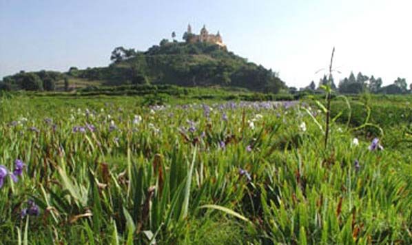
Abstract

The "Dating Cholula" project was designed to develop an independent chronological
sequence for Cholula based on radiocarbon dates derived from excavated
archaeological contexts. Funding provided by FAMSI paid for an initial suite of 16 14C
dates from a number of distinct contexts in Cholula: fill inside the earliest construction
phases of the Great Pyramid (samples obtained by the Tetimpa Project), fill from two
buried adobe platforms to the northeast of the Pyramid (samples obtained by the
Sondeo Arqueológico Rancho de la Virgen 2002), strata with Early Postclassic ceramics
on the north side of the main square of San Pedro Cholula (sample obtained by the
Sondeo Arqueológico Colegio Coley B. Taylor, 2002), and a bell-shaped pit with Middle
Formative ceramics on the Universidad de las Américas campus (samples obtained by
the Rescate Arqueológico UA-03A, 2003). These initial dates allow us to confirm an
early Middle Formative occupation along the southern edge of the swamps, the
emergence of monumental constructions during the second century A.D., and evidence
of a major volcanic event that separates the Classic and Postclassic in Cholula.

Resumen

El proyecto "Fechando Cholula" fue diseñado para desarrollar una secuencia
cronológica independiente para Cholula en base a fechas de radiocarbono derivadas
de contextos arqueológicos excavados. El financiamiento proporcionado por FAMSI se
destinó a pagar una serie de 16 fechas de 14C de distintos contextos en Cholula: relleno
del interior de las fases constructivas más tempranas de la Gran Pirámide (muestras
obtenidas como parte del Proyecto Tetimpa), relleno del interior de dos plataformas de
adobe enterradas al nororiente de la Pirámide (muestras obtenidas en el Sondeo
Arqueológico Rancho de la Virgen 2002), estratos con cerámica del Posclásico
Temprano del lado norte de la plaza principal de San Pedro Cholula (muestras
obtenidas en el Sondeo Arqueológico Colegio Coley B. Taylor, 2002), y un pozo tronco-
cónico con cerámica del Formativo Medio en el campus de la Universidad de las
Américas (muestras obtenidas por el Rescate Arqueológico UA-03A, 2003). Estos
datos iniciales nos permiten confirmar la ocupación del Formativo Medio en las riberas
del lado sur de los pantanos, el surgimiento de construcciones monumentales durante
el segundo siglo d.C., y evidencia de un evento volcánico mayor que separa el Clásico
del Posclásico en Cholula.

Submitted 08/31/2004 by:
Dr. Patricia Plunket
plunket@mail.udlap.mx

Dr. Gabriela Uruñuela
gabriela@mail.udlap.mx

                                            2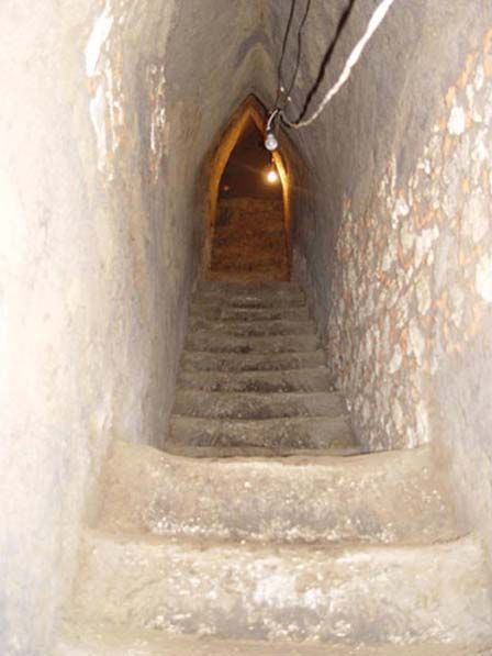
Figure 1. Pyramid of Cholula, Puebla, México.

Introduction

Although Cholula is considered to be one of the major cities of prehispanic México, it
has been the subject of relatively little archaeological work because almost all of the
ancient settlement lies buried beneath the modern city. Most research has focused on
its Great Pyramid, the largest Pre-Columbian structure in the Americas, but the results
of these projects have never been published in detail (López et al. 1976; Marquina
1970b, 1975, 1981; Messmacher 1967; Noguera 1937, 1954, 1956; Romero 1935),
leaving doubts about its initial configuration and the dating of the various construction
stages (see interpretative attempts in McCafferty 1996a and b). Traditionally, the
chronology of Cholula has depended on temporal sequences developed for sites in the
Basin of México, and until recently few absolute dates from archaeological contexts
were available (see Plunket and Uruñuela 1998b, 2002; Siebe et al. 1996; Suárez
1995). Most minor excavations that have taken place in response to development
projects have not been published and no comprehensive interpretive overview of this
archaeological research is currently available.

Because of this situation, it is difficult to understand the origins of urban Cholula and
assess the relationship between the city and other settlements in the Puebla-Tlaxcala

                                            3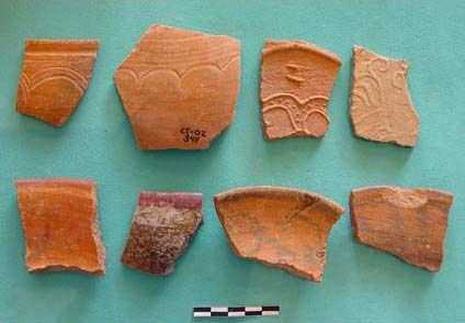
Valley or in greater Mesoamerica. The "Dating Cholula" project was designed to initiate
the development of an independent chronological sequence for Cholula based on
radiocarbon dates from excavated archaeological contexts. In particular, we wanted to
explore the possibility that the monumental architecture of the site developed–at least in
part–as an adaptive politico-religious response as people sought to cope with the
ecological, social, political, economic, and ideological conflicts that certainly developed
in the wake of a huge volcanic eruption of the Popocatépetl volcano, which took place
around the middle of the first century A.D. This spectacular event deposited 3.2 km3 of
pumitic lapilli over an area extending at least 25 km east of the crater; shortly thereafter,
lava flows covered close to 50 km2 of the eastern piedmont of the volcano with between
30 and 100 meters of rock that dammed and diverted drainages, altering the surface
hydrology of the western Puebla valley (Panfil 1996:16-20).
Figure 2. Popocatépetl volcano; the dark band at the base of the volcano is the lava flow known
as the Pedregal de Nealtican.
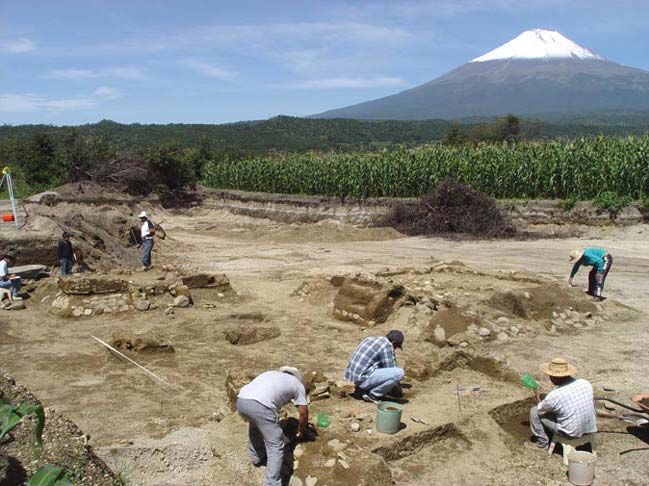
We have focused heavily on dating of the earliest construction phases of the Great
Pyramid that are exposed in tunnels excavated by Ignacio Marquina (1970a, 1981) in
order to provide a chronological framework for the first monumental architecture in the
ceremonial heart of the emergent city. In addition, we have obtained samples from
various other contexts that have become available to us through test excavations and
rescue work (López et al. 2002a and b, 2004a and b; Plunket and Uruñuela 2002). This
4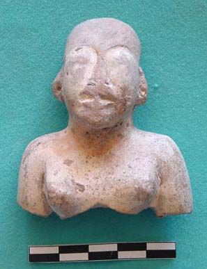
second group of dates is important since it can be used to anchor the ceramic
assemblages in time.

Figure 3. View of house compound (Op. 31) at Tetimpa with the Popocatépetl volcano rising in the
                                        background.

"Dating Cholula" forms part of the Tetimpa Project whose primary goal has been to
study the impact of volcanic activity on the western Puebla Valley. Up until recently,
most of our work has centered on the Formative village of Tetimpa, which was buried
under the pumitic ash deposited in the first century A.D. The research described in this
report represents an attempt to expand our knowledge beyond the immediate
boundaries of the territory directly affected by pyroclastic materials and look at a major
settlement that must have received refugees at the same time that it had to deal with
significant environmental consequences. Dating different areas and occupations within
Cholula can help us develop before and after views of the city which will be of central
importance to any consideration of the regional effects of the natural disaster.
Additionally, we have sought to address the chronology of the Classic-Postclassic
transition since Siebe and his colleagues (1996) have suggested that Cholula and its

                                               5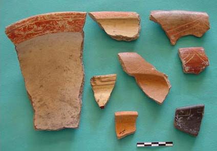
region were impacted by a second major volcanic eruption, sometime in the eighth or
ninth centuries (see also Panfil 1996).

        Figure 4. Map of Cholula indicating areas from which 14C dates were obtained.

Methodology

The funding provided by FAMSI was specifically used to pay for a suite of 16 14C dates
from Cholula (Figure 4, shown above). Ten AMS dates were derived from samples
obtained from distinct layers of fill associated with the initial construction phases of the
Cholula Pyramid (as part of the Tetimpa Project), while another three determinations
came from the fill of two adobe platforms uncovered during test excavations in a field
adjacent to the northeast corner of the Pyramid complex, just to the northeast of the
platform known as the Edificio Rojo (Noguera 1956) (as part of the Sondeo
Arqueológico Rancho de la Virgen 2002). Additionally, stratigraphic excavations on the
north side of the main plaza of San Pedro Cholula (as part of the Sondeo Arqueológico
Colegio Coley B. Taylor 2002), in an open space on the east side of the Casa del
Caballero Aguila (now the Museo de la Ciudad de Cholula), provided us with two carbon
samples associated with Early Postclassic ceramics. A final date came from charcoal
recovered from a Formative bell-shaped pit on the Universidad de las Américas

                                             6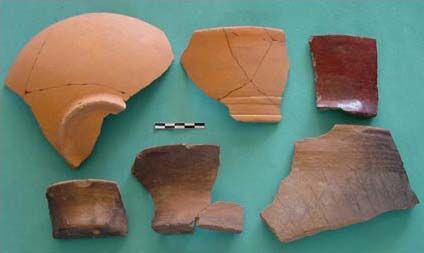
campus, which is located on the eastern side of modern Cholula (as part of the Rescate
Arqueológico UA-03A). All samples were exported with the permission of the Consejo
de Arqueología of the Instituto Nacional de Antropología e Historia, and processed by
Beta Analytic in Miami, Florida.

In order to make better sense of the dates from the Great Pyramid, as part of the
Tetimpa Project, Amparo Robles is currently making a 3D computer map with a total
station of the initial construction phases for her licenciatura thesis. All dating samples
have been located on this map. She has also undertaken a detailed description of the fill
visible in the tunnel walls in order to better relate the dates to the building sequence.
These descriptions will be a useful interpretive tool as we try to understand the
development of the Great Pyramid. This is a work in progress: to date, over 1500 m
have been mapped and 240 m have been recorded and described.

Discussion of Results

The Cholula Pyramid

The mapping and description of the fill visible in the tunnel profiles shows that the
stepped platform Marquina identified as the initial structure (Structure I, phase A) is
actually the second building stage of the Great Pyramid. An unrecorded irregular pit
excavated into the occupation surface on the west side of the Pyramid, in front of the
central staircase of Structure I-A, penetrates to a depth of about 2 m; the east wall of
this pit was then excavated to create a tunnel that perforates beneath Structure I-A
approximately 53 m until it terminates in a an adobe cell ("cajón") that forms part of an
earlier two-tiered platform (Structure Sub-I-A) (see McCafferty 2001 for a different
interpretation). This tunnel was obviously not excavated by Marquina’s team since it is
not recorded on any of his plans, nor does it conform to his very exacting standards.
However, it cuts through Structure Sub-I-A–the remains of an earlier unsurfaced
platform constructed of an adobe grid filled with crushed tepetate and occasional trash
lenses–which rests directly on sterile subsoil (tepetate). The location of this initial
construction phase and its precise relation to the later construction stages of the
pyramid will appear on the computer map. We have three AMS dates from the adobe fill
of Structure Sub-I-A, which indicate that it was erected sometime between the first and
third centuries A.D. The 2 Sigma range of these radiometric determinations is as
follows: B-162997 [cal A.D. 110 to 330], B-188345 [cal 5 B.C. to A.D. 230], and B-
188346 [cal A.D. 60 to 260].

                                            7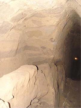
Figure 5. Pit 2 excavated into sterile tepetate underneath the Great Pyramid.

Further evidence for dating this early structure comes from six bell-shaped pits
excavated into the sterile tepetate and exposed in the walls of the unrecorded tunnel
beneath the phase A construction (Figure 5, shown above). Two carbonized beans and
an unidentified seed from these features provided three AMS dates: B-188342 [cal A.D.
115 to 385], B-188343 [cal A.D. 45 to 250], and B-188344 [cal 30 B.C. to A.D. 225]. It
would appear that the pits probably were filled between A.D. 100 and 200 as part of a
resurfacing program related to preparations for the construction of the first stage of the
Great Pyramid. Taken together with three dates from inside the reticulated adobe cells
of Structure Sub-A (B-162997, B-188345 and B-188346), we can tentatively suggest
that this first construction phase was undertaken during the second century A.D. (Table
1 and Table 2).

It is important to note here that other monumental architecture in Cholula also has been
dated to this time period. Excavations at the Franciscan monastery of San Gabriel on
the east side of the main square of the modern city uncovered the well-preserved
staircase–over 12 m wide with more than 13 steps–of a large east-facing platform that
continues under the kitchen of the sixteenth-century building and the adjoining school
yard. This platform also was constructed on sterile subsoil. A 14C determination on

                                               8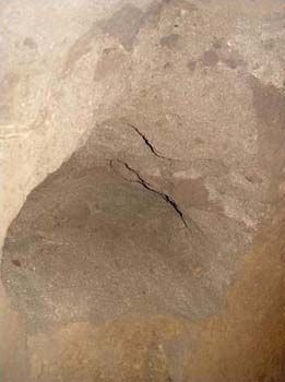
charcoal from a hearth associated with the superstructure of this platform provided a
date of 1890 ± 80 BP (I-17,627) with a 2 Sigma range of cal B.C. 41 to A.D. 268 and cal
A.D. 273 to 336 (Plunket and Uruñuela 2002), placing this construction in the second
and third centuries A.D.

Marquina (1981:121) considered that Structure I (which covers Structure Sub-I-A)
belonged to the Teotihuacán I period, or Tzacualli phase (A.D. 1-150). This building
consists of two stages. He indicates that stage A is an undecorated stepped platform
that faces west and is divided into two groups: a basal series of five levels that is
crowned by an additional set of two upper levels. Stage B corresponds to certain
modifications and enlargements of the north side of the stage A structure, where talud-
tablero profiles were added to the upper two levels; he assures us that the addition of
the talud-tablero profile distinguishes phase A from phase B. These tableros are
painted with the Chapulines Murals. From Marquina’s description, it would appear that
stage B was also characterized by a new ideological program encapsulated in the mural
art that accompanied the reorientation of the building from the west to the north. The
decorated tableros are located on the north side of the building and wrap around the
east and west corners. At the center of the north side, the talud-tablero façade is
interrupted by a void which must have held a staircase although none is present.
Marquina associated this architectural change in the Great Pyramid with the
Teotihuacán II period (Miccaotli phase, A.D. 150 to 200) because of certain similarities
between this building and the Feathered-Serpent Temple at Teotihuacán (i.e., the
decorated tableros), although there is no emphasis on the northern direction in that
building.

The change in the orientation of the façade between phases A and B is puzzling since it
only affects the upper two levels of the structure that bear the mural art. We are
currently trying to understand exactly what evidence Marquina used to suggest that the
talud-tablero profile was added to the existing phase A structure, but we have yet to find
any. Indeed, the alfardas of the staircase that rises on the west side of the stage A
structure were put in place after the painted tableros were finished. This seems to
indicate that stages A and B were part of the same building program, but we have not
finished our evaluation of the structural details visible in the tunnels and prefer not to
make any definitive statements yet.

We have no dates from the fill inside the phase A structure of the Pyramid since none of
Marquina’s tunnels penetrated this building. However, the two dates that were obtained
on materials recovered from the fill covering the west side of phase A near the central
staircase (B-162998 [cal A.D. 220 to 450] and B-188347 [cal A.D. 95 to 265 and cal
A.D. 290 to 325]) suggest that a new version of the monument (Structure II) was built
between the third and fifth century A.D. (Table 1 and Table 2).

A small amount of charred material was recovered from between the clay plaster and
stone body of one of the tableros of the phase B construction. This provided a date with
a 2 Sigma range of cal B.C. 40 to A.D. 215 (B-188348). This early date may indicate
that phase B was added shortly after the completion of phase A, or that as we have
already suggested, stages A and B are actually part of the same building, but it also

                                            9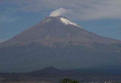
could result from earlier carbon being incorporated into the building. This is a distinct
possibility considering that there are Terminal Formative structures in the vicinity of the
Great Pyramid. Additionally, we recovered two dates (AMS) from charred materials in
the fill deposited on top of the north façade of Structure I-B. The 2 Sigma range is
between cal A.D. 155 to 390 (B-188349) and cal B.C. 80 to A.D. 120 (B-198350). This
second date is very early and probably results from incorporating older materials into
the fill used to cover the phase B structure, while the first date (B-188349) may signal
new building activity at the Great Pyramid in the third or fourth century A.D. It is
consistent with the dates from the fill on the west side of the pyramid that provided
determinations of A.D. 220 to 450 (B-162998) and cal A.D. 95 to 265 and cal A.D. 290
to 325 (B-188347) (Table 2). Taken together, these dates allow us to suggest that
Structure I (phases A and B) was covered over with an entirely new building program
(Structure II, the "stepped" pyramid) between the third and fifth century A.D.

                                            10
Figure 6. East-West tunnel, following the central staircase of phase A construction.
Marquina (1970a:39) mentions that the north façade of Structure I-B underwent further
episodes of modification and enlargement although he provides few details. In her
survey of the tunnel walls, Amparo Robles found that there is another talud-tablero
façade on the north side that was sliced by the tunnels in the fill that covers Structure I-
B, and we have designated this as Structure I-B1. We recovered a small sample of
11charred material from the fill placed on top of this additional talud-tablero profile, which
provided an AMS date with a 2 Sigma range of cal 40 B.C. to A.D. 215 (B-188351).
Although this result might indicate that structures I-A, I-B, and I-B1 were built in rapid
succession, we think it is more likely that the Pyramid’s architects commonly mined
middens from surrounding areas for fill. Significantly, the date does not conflict with our
suggestion that Structure I was covered over with an entirely new building (Structure II)
perhaps as early as the third or as late as the fifth century A.D.
Figure 7. Collapse within Túnel 46, exposing adobe wall 49.
12Table 1.
Radiocarbon dates (AMS) obtained from samples associated
with early construction phases of the Cholula Pyramid (2003).
Beta Years BP Context Intercept 1 Sigma 2 Sigma
188342 1790 ± 50 carbonized bean from bell-shaped cal A.D. 240 cal A.D. 155-265 cal A.D. 115-385
(AMS) pit beneath Structure I-A (Pit 1) cal A.D. 290-325
188343 1870 ± 50 fragment of carbonized bean from cal A.D. 130 cal A.D. 80-225 cal A.D. 45-250
(AMS) bell-shaped pit beneath Structure I-
A (Pit 1)
188344 1920 ± 50 carbonized seed from bell-shaped cal A.D. 80 cal A.D. 45-130 cal B.C. 30 - A.D. 225
(AMS) pit beneath Structure I-A (Pit 2)
188345 1910 ± 50 carbonized bean from sandy fill cal A.D. 85 cal A.D. 55-135 cal B.C. 5 - A.D. 230
(AMS) between adobe walls of Structure
Sub-I-A
188346 1850 ± 50 carbonized maize kernel from sandy cal A.D. 140 cal A.D. 95-235 cal A.D. 60-260
(AMS) lens between the two stepped
bodies of Structure Sub-I-A
188347 1820 ± 40 carbonized maize kernel from trash cal A.D. 225 cal A.D. 135-245 cal A.D. 95-265 &
(AMS) lens within fill placed over west side cal A.D. 290-325
of Structure I-A close central
staircase
188348 1930 ± 50 charred material from the east side cal A.D. 75 cal A.D. 30-120 cal B.C. 40 - A.D. 215
(AMS) of the second level of Structure I-B
(Chapulines mural) between the clay
plaster and the base of the tablero
188349 1760 ± 40 charred material from fill placed cal A.D. 255 cal A.D. 235-340 cal A.D. 155-390
(AMS) directly on top of the second level of
the north face of Structure I-B
(Chapulines mural)
188350 1980 ± 50 charred material from fill placed cal A.D. 30 cal B.C. 40 - A.D. 75 cal B.C. 80 - A.D. 120
(AMS) directly on top of the second level of
the north face of Structure I-B
(Chapulines mural)
188351 1930 ± 50 charred material from fill placed cal A.D. 75 cal A.D. 30-120 cal B.C. 40 - A.D. 215
(AMS) directly on top of the second level of
the north face of Structure I-B1
The dates we obtained from the early structures of the Great Pyramid are fairly
consistent even though they come from fill, which is not the best context for dating
purposes. Taken as a whole, however, the suite of 12 radiocarbon dates (Table 1 and
Table 2) documents intense building activity with continuous design modifications in the
ceremonial heart of Cholula during the second and third centuries A.D. This
construction was initiated after the volcanic eruption that destroyed the village of
Tetimpa, a fact that requires us to reconsider the motivation behind the massive building
programs that characterize the Classic period at Cholula.
13Table 2.
Previous radiocarbon dates obtained from the Cholula Pyramid (2002).
Beta Years BP Context Intercept 1 Sigma 2 Sigma
162997 1810 ± 40 charred material from fill of phase cal A.D. 230 cal A.D. 140-250 cal A.D. 110-330
(AMS) Sub-A
162998 1700 ± 60 charred material from fill covering W cal A.D. 370 cal A.D. 250-410 cal A.D. 220-450
façade of Structure I-A
Figure 8. Chronological graph of radiocarbon dates associated with the early construction
phases of the Cholula Pyramid.
14Rancho de la Virgen
In a large open field known as Rancho de la Virgen, located to the northeast of the
Edificio Rojo that rises at the northeast corner of the Great Pyramid, the Coordinación
de Apoyo Arqueológico of the Universidad de las Américas, Puebla, undertook test
excavations in 2002 (López et al. 2002a and b). Four adobe platforms were recorded
1.80 to 3.60 meters below the surface in the test pits. We recovered two samples of
charred material from the two superimposed adobe platforms in Pit 5, while more
organic material came from a water well excavated into the surface of another adobe
platform located in Pit 6. All of these dates have 2 Sigma ranges that indicate activity in
the Late and Terminal Formative, spanning the second century B.C. through the middle
of the third century A.D. Noguera (1956) reported significant amounts of Late Formative
material from his excavations at the Edificio Rojo. It would appear then that the area to
the north of the Great Pyramid witnessed an important occupation during this time
period. However, most of the ceramics associated with the surface of these platforms
are from the Early Classic, when the Teotihuacán Tlamimilolpa styles were important
and significant amounts of Thin Orange were in use (Figure 9, shown below).
Figure 9. Sample of Classic period ceramics recovered from the water well (Feature 1, Pit 6) at the
Rancho de la Virgen.
The three calibrated dates from the test excavations span a period between 195 B.C.
and A.D. 250. The Sub-I-A platform at the core of the Great Pyramid was built in the
second half of this period, as were phases I-A, I-B, and I-B1. The fill placed over this
building sequence doubtless contains trash generated by the inhabitants of the Rancho
15de la Virgen; and it is also likely that the façades of the adobe platforms in this low-lying,
swampy area were mined for stone since we found little evidence of stone platform
surfaces even though these were commonly used in western Puebla during the
Formative and Classic (Mountjoy and Peterson 1973; Plunket and Uruñuela 1998a).
Table 3.
Radiocarbon dates obtained from samples associated with adobe platforms to the northeast of the Cholula
Pyramid (Sondeo Arqueológico Rancho de la Virgen 2002).
Beta Years BP Context Intercept 1 Sigma 2 Sigma
188352 2010 ± 80 charred material from adobe wall of cal B.C. 5 cal B.C. 100 - cal B.C. 195 -
Structure 2 in Pit 5 (Wall 1) A.D. 75 A.D. 140
188353 2030 ± 70 charred material from adobe wall of cal B.C. 40 cal B.C. 115 - cal B.C. 195 -
Substructure 1 in Pit 5 (Wall 4) A.D. 55 A.D. 115
188354 1970 ± 100 charred material from inside water well cal A.D. 45 cal B.C. 60 - cal B.C. 195 -
(Feature 1, Pit 6) A.D. 130 A.D. 250
The Classic occupation is sealed by an airfall deposit of angular volcanic sand that
appears to correspond to an important eruption of the Popocatépetl volcano that took
place between A.D. 700 and 850 (Panfil 1996; Siebe 1996). The Postclassic inhabitants
of Cholula built new houses directly on top of this sandy layer, and in general it can be
used to divide the Classic and Postclassic in the area.
UA-03A-1
Construction work on the north side of the Universidad de las Américas, Puebla campus
uncovered six bell-shaped pits and a circular oven excavated into sterile tepetate
(López et al. 2004b). These features contained ceramic materials similar to those
recovered in 1969 and 1970 by Mountjoy and Peterson (1973:13-19, 46-56). The pits
are in an area of thin soils, generally between 0.40 and 0.50 m, that borders a swampy
drainage system filled with thick black clay. Mountjoy and Peterson (1973:13) found
Middle Formative materials along the edge of this swamp, about 150 meters north of the
bell-shaped pits we excavated in 2003. Although these pits undoubtedly form part of
one or more Middle Formative residences along the shores of the swamp, structural
elements have been damaged or destroyed by plowing and construction activities, and
all that remains are materials contained in pits excavated into the sterile subsoil. The
ceramics recovered from these bell-shaped pits are the earliest with archaeological
provenience for Cholula, and they extend the occupation of the area back to the
beginning of the Middle Formative (Figure 10, shown below, and Figure 11). A sample
of charred material recovered from one of these features (Feature 1) provided a
radiocarbon date with a 2 Sigma range of cal B.C. 1260 to 795 and an intercept at cal
B.C. 930 (Beta 188355), the earliest dated material recorded for Cholula (Table 4).
16Figure 10. Sample of ceramics recovered from bell-shaped pits on the Universidad de las
Américas, Puebla campus.
Mountjoy and Peterson (1973:62) obtained a 14C date on partially carbonized wood
associated with Middle Formative ceramics and figurines from the lower levels of the
swamp clay. The sample (GX-2256) yielded a determination of 2645 ± 110 radiocarbon
years or a non-calibrated date of 695 ± 110 B.C. By running this sample through the
Radiocarbon Calibration Program Rev 4.3 (Struiver and Reimer 1993), we obtained an
intercept of cal 804 B.C. This date overlaps with the one from the bell-shaped pit, and
helps confirm the Middle Formative occupation along the south shore of the Cholula
swamp.
17Figure 11. Figurine from bell-shaped pit on Universidad de las Américas, Puebla campus.
Table 4.
Radiocarbon date on charcoal from a bell-shaped pit on the Universidad de las Américas campus on the
eastern edge of Cholula (Rescate Arqueológico UA-03A, 2003) and calibration of Mountjoy and Peterson's
date (1973:62).
Lab Years BP Context Intercept 1 Sigma 2 Sigma
Beta 2800 ± 100 charred material from bell- cal B.C. 930 cal B.C. 1055-830 cal B.C. 1260-795
188355 shaped pit (Feature 1)
GX- 2645 ± 110 carbonized wood from Pit 6, cal B.C. 804 cal B.C. 901-765 cal B.C. 1010-412
2256 Mountjoy and Peterson
excavations (1973)
18Colegio Taylor
In May and June of 2002, the Coordinación de Apoyo Arqueológico of the Universidad
de las Américas, Puebla, undertook test excavations in a plot of land in the middle of
the block that borders the north side of the main square of San Pedro Cholula (López et
al. 2002b, 2004a). Although a complex sequence of modern and colonial construction
was documented in the 12×2 meter east-west exploratory trench, no remains of
prehispanic buildings were located in this excavation. The post-Conquest building
activity rests upon about 2.50 meters of interdigitated clays and sands. The lower part of
these strata consists of dark clays that contain Late Classic ceramics, deposited directly
on the sterile tepetate. These clays are sealed by a 0.20 to 0.30 meter layer of volcanic
ash. On top of this ash, Postclassic ceramics, like Cocoyotla Black-on-Orange, which is
similar to Aztec I, occur for the first time (Figure 12, shown below). The two dates we
obtained from this excavation come from two different strata of waterlain sediments
deposited above the volcanic ash.
Figure 12. Sample of ceramics from Level K in excavations at the Colegio Taylor.
19Table 5.
Radiocarbon dates from charcoal associated with Epiclassic/Early Postclassic ceramics found in test
excavations on the north side of the main plaza of San Pedro Cholula
(Sondeo Arqueológico Colegio Coley B. Taylor, 2002).
Beta Years BP Context Intercept 1 Sigma 2 Sigma
188340 970 ± 50 charred material from Layer K, cal A.D. 1030 cal A.D. 1010-1055 cal A.D. 990-1185
Pit S2E4: Early Postclassic &
ceramics above volcanic ash cal A.D. 1085-1150
188341 1040 ± 130 Charred material from Layer M, cal A.D. 1005 cal A.D. 880-1155 cal A.D. 690-1260
Pit S2E4: Early Postclassic
ceramics above volcanic ash
Concluding Remarks
The dated contexts presented in this short study allow us to make several preliminary
observations about the chronology of Cholula. First of all, the Middle Formative
occupation along the southern edge of the swamps on the northeastern side of Cholula
appears to be much as Mountjoy and Peterson (1973) envisioned, albeit somewhat
earlier. The materials they recovered were from within the swamp muck, and probably
represent trash thrown into the shallow water. The bell-shaped pits, on the other hand,
are features that correspond to Middle Formative houses that have not survived two
millennia of agricultural activity on the shallow soils that characterize the southern shore
of the swamp. The high tepetate here made it an ideal area for construction since it was
elevated enough to avoid flooding during the rainy season. A detailed study of the
ceramics from these pits is currently underway.
After establishing a mid-first century date for a major volcanic eruption of Popocatépetl
through our work at Tetimpa (Plunket and Uruñuela 2000 and n.d.), we wanted to
explore the possibility that monumental architecture at the site developed as an
adaptive politico-religious response as people sought to cope with the numerous
conflicts that must have emerged in the aftermath of the catastrophe. Although our
dates come from fill inside the Great Pyramid, and we are well aware of the problems of
using fill for the construction of chronological sequences, we believe that the
consistency of the 12 determinations, confirms an early second century A.D. date for
the initial building phase of this important structure. Interestingly, this dating is similar to
that of the Moon Pyramid at Teotihuacán (Kabata et al. 2001), and perhaps signals
related processes at work on both sides of the Sierra Nevada after the great eruption.
Our interpretation of the dates from fill covering the construction set formed by the Sub-
I-A/I-A/I-B/I-B1 building sequence suggests that it was covered over with an entirely new
conception of the Great Pyramid (Marquina’s Structure II) in the fourth or early fifth
20century A.D. However, we will not begin to explore this building until we have a clear
understanding of the construction sequence underneath it.
The dates from the Colegio Taylor indicate that the area to the north of the main square
in San Pedro Cholula was devoid of Classic period construction, and also that the
second major eruption visible in the stratigraphy at Tetimpa occurs as a marked strata
in Cholula that separates the Classic from the Postclassic.
Acknowledgements
We would like to thank the Consejo de Arqueología of the Instituto Nacional de
Antropología e Historia for granting us the permit to map the inner structures of the
Cholula Pyramid and take samples for radiocarbon dating. In particular, we are indebted
to Eduardo Merlo, from the Centro INAH-Puebla, for helping us with the logistics of the
tunnels and guiding us through the maze during the early stages of this work, and to
Martín Cruz for various courtesies. Amparo Robles, aided by Aurelio López and Manuel
Vera, is responsible for the mapping, which has provided part of the information used in
this report. The carbon samples from the Rancho de la Virgen, the Colegio Taylor, and
the university campus were recovered by the crew of the Coordinación de Apoyo
Arqueológico of the Universidad de las Américas headed by Gabriela Uruñuela; the
hard work of Aurelio López, Marisol Talavera, and Araceli Rojas was instrumental in
recording the archaeological contexts, recovering the organic material, and analyzing
the associated artifacts. We would also like to thank the authorities of the Universidad
de las Américas, Puebla, who, in approving and funding the Coordinación de Apoyo
Arqueológico, have provided a mechanism for rigorous, systematic fieldwork–albeit in a
limited number of venues–within the sacred city of Cholula.
List of Figures
Figure 1. Pyramid of Cholula, Puebla, México.
Figure 2. Popocatépetl volcano; the dark band at the base of the volcano is the lava
flow known as the Pedregal de Nealtican.
Figure 3. View of house compound (Op. 31) at Tetimpa with the Popocatépetl volcano
rising in the background.
Figure 4. Map of Cholula indicating areas from which 14C dates were obtained.
Figure 5. Pit 2 excavated into sterile tepetate underneath the Great Pyramid.
Figure 6. East-West tunnel, following the central staircase of phase A construction.
21Figure 7. Collapse within Túnel 46, exposing adobe wall 49.
Figure 8. Chronological graph of radiocarbon dates associated with the early
construction phases of the Cholula Pyramid.
Figure 9. Sample of Classic period ceramics recovered from the water well (Feature 1,
Pit 6) at the Rancho de la Virgen.
Figure 10. Sample of ceramics recovered from bell-shaped pits on the Universidad de
las Américas, Puebla campus.
Figure 11. Figurine from bell-shaped pit on Universidad de las Américas, Puebla
campus.
Figure 12. Sample of ceramics from Level K in excavations at the Colegio Taylor.
List of Tables
Table 1. Radiocarbon dates (AMS) obtained from samples associated with early
construction phases of the Cholula Pyramid (2003).
Table 2. Previous radiocarbon dates obtained from the Cholula Pyramid (2002).
Table 3. Radiocarbon dates obtained from samples associated with adobe platforms to
the northeast of the Cholula Pyramid (Sondeo Arqueológico Rancho de la Virgen 2002).
Table 4. Radiocarbon date on charcoal from a bell-shaped pit on the Universidad de las
Américas campus on the eastern edge of Cholula (Rescate Arqueológico UA-03A,
2003) and calibration of Mountjoy and Peterson’s date (1973:62).
Table 5. Radiocarbon dates from charcoal associated with Epiclassic/Early Postclassic
ceramics found in test excavations on the north side of the main plaza of San Pedro
Cholula (Sondeo Arqueológico Colegio Coley B. Taylor, 2002).
22Sources Cited
Kabata, Shigeru, Saburo Sugiyama, Anthony Aveni, and Tatsuya Murakami
2001 "Architectural Sequence of the Early Monuments at the Moon Pyramid,
Teotihuacán." Paper presented to the LXVI Annual Reunion of the Society for
American Archaeology, New Orleans.
López, Aurelio, Soledad Talavera, Araceli Rojas, Gabriela Uruñuela, and Patricia
Plunket
2002a "Sondeo Arqueológico Rancho de la Virgen 2002: Informe Técnico de Campo."
Report submitted to the Consejo Nacional de Arqueología, INAH, Archivo
Técnico, México City.
2002b "Sondeo Arqueológico Colegio Coley B. Taylor: Informe Técnico de Campo."
Report submitted to the Consejo Nacional de Arqueología, INAH, Archivo
Técnico, México City.
López, Aurelio, Soledad Talavera, Gabriela Uruñuela, and Patricia Plunket
2004a "Sondeo Arqueológico Colegio Coley B. Taylor: Análisis de Materiales." Report
submitted to the Consejo Nacional de Arqueología, INAH, Archivo Técnico,
México City.
López, Aurelio, Soledad Talavera, Araceli Rojas, Gabriela Uruñuela, and Patricia
Plunket
2004b "Rescate Arqueológico UA-03A. Informe Técnico de Campo y Análisis de
Materiales." Report submitted to the Consejo Nacional de Arqueología, INAH,
Archivo Técnico, México City.
López, Sergio, Zaid Lagunas, and Carlos Serrano
1976 Enterramientos humanos de la zona arqueológica de Cholula,
Puebla, Colección Científica 44, Instituto Nacional de Antropología e Historia,
México City.
Marquina, Ignacio
1975 "Cholula, Puebla." In Los pueblos y señoríos teocráticos: el periodo de las
ciudades urbanas, primera parte, Matos, E. (ed.), Secretaría de Educación
Pública and Instituto Nacional de Antropología e Historia, México City, pp. 109-
122.
1970a "Pirámide de Cholula." In Proyecto Cholula. Serie de Investigaciones No. 19,
edited by I. Marquina, pp. 31-45. INAH, México City.
231981 Arquitectura Prehispánica, Tomo I, Instituto Nacional de Antropología e
Historia, México City. (Originally published in 1951).
Marquina, Ignacio (editor)
1970b Proyecto Cholula, Serie Investigaciones No. 19, Instituto Nacional de
Antropología e Historia, México City.
McCafferty, Geoffrey
1996a "Reinterpreting the Great Pyramid of Cholula, México." In Ancient
Mesoamerica 7(1):1-17.
1996b "The Ceramics and Chronology of Cholula, México." In Ancient
Mesoamerica 7(2):299-324.
2001 "Mountain of heaven, mountain of earth: the Great Pyramid of Cholula as
sacred landscape." In Landscape and Power in Ancient Mesoamerica, edited
by Rex Koontz, Kathryn Reese-Taylor, and Anabeth Headrick, pp. 279-316.
Westview Press, Boulder.
Messmacher, Miguel
1967 Cholula, reporte preliminar, Editorial Nueva Antropología, México City.
Mountjoy, Joseph and David Peterson
1973 Man and Land at Prehispanic Cholula. Vanderbilt University Publications in
Anthropology No. 4. Vanderbilt University, Nashville.
Noguera, Eduardo
1937 El Altar de los Cráneos Esculpidos de Cholula. Talleres Gráficos de la Nación,
México City.
1954 La cerámica arqueológica de Cholula. Editorial Guarania, México City.
1956 "Un edificio preclásico en Cholula." In Estudios Antropológicos publicados en
Homenaje al Dr. Manuel Gamio, Dirección General de Publicaciones,
Universidad Nacional Autónoma de México, México City, pp. 213-224.
24Panfil, Maria S.
1996 The Late Holocene Volcanic Stratigraphy of the Tetimpa Area, Northeast Flank
of Popocatépetl Volcano, Central México, Unpublished MS Thesis in
Geosciences, Pennsylvania State University, College Park.
Plunket, Patricia and Gabriela Uruñuela
1998a "Preclassic Household Patterns Preserved under Volcanic Ash at Tetimpa,
Puebla." In Latin American Antiquity 9(4):287-309.
1998b "Cholula y Teotihuacán." In Rutas de Intercambio en Mesoamérica, Memorias
del III Coloquio Pedro Bosch-Gimpera, Rattray, E.C. (ed.), IIA-UNAM, México
City, pp. 101-114.
2000 "The Archaeology of a Plinian Eruption of the Popocatépetl Volcano." In The
Archaeology of Geological Catastrophes, W.J. McGuire, D.R. Griffiths, P.L.
Hancock, and I.S. Stewart, editors, pp. 195-203. Geological Society Special
Publication No. 171, Bath.
2002 "Antecedentes prehispánicos." In Cholula, un vínculo de sabiduría y
fraternidad, pp. 19-27. Universidad de las Américas, Puebla, Cholula.
n.d. "Recent Research in Puebla Prehistory." In Journal of Archaeological
Research (in press), MS 2004.
Romero, Javier
1935 "Estudio de los entierros de la Pirámide de Cholula." In Anales del Museo
Nacional de Antropología, Historia y Etnografía, Época 5, tomo 2.
Siebe, C., M. Abrams, J.L. Macías, and J. Obenholzner
1996 "Repeated volcanic disasters in Prehispanic time at Popocatépetl, central
México: Past key to the future?" In Geology 24(5):399-402.
Struiver, M. and P.J. Reimer
1993 "Radiocarbon Calibration Program Rev 4.3." In Radiocarbon 35:215-240.
Suárez, Sergio
1995 "La cerámica Lisa cholulteca." In Arqueología 13-14:109-120.
25You can also read