INS-DM GPS-Aided Inertial Navigation System - GPS-Aided INS-DM Datasheet Revision 1.18
←
→
Page content transcription
If your browser does not render page correctly, please read the page content below
GPS-Aided INS-DM
                                                                               Datasheet Revision 1.18

GPS-Aided
Inertial Navigation System
INS-DM

    Inertial Labs Address: 39959 Catoctin Ridge Street, Paeonian Springs, VA 20129 U.S.A.     1
                   Tel: +1 (703) 880-4222, Website: www.inertiallabs.com
GPS-Aided INS-DM
                                                                                       Datasheet Revision 1.18
The Inertial Labs GPS-Aided Inertial Navigation System (INS-DM) is the latest version of
Inertial Navigation System, developed by Inertial Labs. The INS-DM is the result of over 20 years of
our experience in developing and supplying INS solutions to land, marine and aerial platforms around
the world.
This system, the INS-DM, is an IP68 rated version of an all-new generation of super ruggedized,
shielded from the EMC/EMI, fully-integrated, combined Inertial Navigation System (INS) + Attitude
& Heading Reference System (AHRS) + Air Data Computer (ADC) high-performance strapdown
system, that determines position, velocity and absolute orientation (Heading, Pitch and Roll) for any
device on which it is mounted. Horizontal and Vertical Position, Velocity and Orientation are
determined with high accuracy for both motionless and dynamic applications.
                                         The Inertial Labs INS-DM can support multiple types of
                                         MEMS Inertial Measurement Units (IMU) developed by
                                         Inertial Labs. Additionally, the INS-DM supports other
                                         IMU’s, like the Honeywell HG4930. The INS-DM also
                                         utilizes different multi constellation (GPS, GLONASS,
                                         GALILEO, QZSS and BEIDOU) GNSS receivers like Novatel
                                         OEM7 series or the uBlox F9 series.
                                         The design of the INS-DM also includes an optional Air
                                         Data Computer (ADC), supported by two barometers, and
                                         the ability to support an external Stand-Alone Magnetic
                                         Compass (SAMC). The INS-DM contains Inertial Labs new
                                         on-board sensor fusion filter, state of the art navigation and
                                         guidance algorithms, and calibration software.

                      KEY FEATURES, BENEFITS & FUNCTIONALITY

•   Commercially exportable GPS-Aided Inertial Navigation System
•   3-in-1 strapdown system: INS + AHRS + ADC (Air Data Computer)
•   Embedded Honeywell or Inertial Labs MEMS Inertial Measurement Unit (IMU)
•   Novatel OEM7 or UBlox ZED-F9P F9 High Precision GNSS receiver
•   GPS, GLONASS, GALILEO, BEIDOU, QZSS, RTK supported signals
•   Total and Static Pressure Sensors for calculating Indicated Airspeed
•   SP, SBAS, DGPS, RTK and PPP for real time operation
•   GNSS measurements and IMU raw data for post processing
•   Advanced, extendable, embedded Kalman Filter based sensor fusion algorithms
•   State-of-the-art algorithms for different dynamic motions of Helicopters, and UAV
•   Full temperature calibration of all sensing elements
•   EMC, EMI and ERD protection
•   Environmentally sealed (IP68)
•   Aiding data: Wind sensor, Air Speed Sensor, Doppler shift from locator (for long-term
    GPS denied), External position and External Heading

            Inertial Labs Address: 39959 Catoctin Ridge Street, Paeonian Springs, VA 20129 U.S.A.     2
                           Tel: +1 (703) 880-4222, Website: www.inertiallabs.com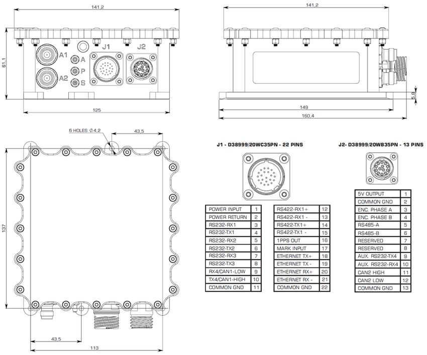
GPS-Aided INS-DM
                                                                                                         Datasheet Revision 1.18
                                    Optional Input Signals
                                     • External Magnetometer, Wind sensor, Air Speed Sensor, Doppler shift from locator (for long-term GPS
                                       denied), External position and External Heading aiding data
                                    Output Signals
                                     • IMU data: Accelerations, Angular rates, Magnetic field;
                                     • AHRS data: Heading, Pitch & Roll

General                              • INS data: Positions, Velocity, Delta Theta and Delta Velocity, GNSS data, Time
                                     • Air Data Computer data: Static Pressure (calibrated), Dynamic Pressure (calibrated), Baro-Corrected Pressure
                                       Altitude, Pressure Altitude, Calibrated Airspeed, True Airspeed, Mach-Number, Static Pressure Over Total
                                       Pressure, True Angle of Attack, Rate of Climb
                                    Electrical & Mechanical
                                                                     Update rate 1 … 200 Hz (INS & AHRS data); up to 2000 Hz (IMU data)
                                                                    Start-up time
GPS-Aided INS-DM
                                                                                                                                                                                                                                   Datasheet Revision 1.18

GNSS
Receiver
Options                                                                                                                       Novatel OEM7720                                                                                                                       uBlox ZED-F9P
Specifications
        Number of GNSS Antennas                                                                                       Dual                                                                                                                          Dual
                                                                                               GPS L1 C/A, L1C, L2C, L2P, L5; GLONASS L1 C/A,                                                                                     GPS L1C/A L2C, GLONASS L1OF L2OF, Galileo
                                                                                                L2 C/A, L2P, L3, L5; BeiDou B1I, B1C, B2I, B2a,                                                                                   E1B/C E5b, BeiDou B1I B2I, QZSS L1C/A L2C
                                    GNSS constellations
                                                                                               B3I; Galileo E1, E5 AltBOC, E5a, E5b, E6; NavIC
                                                                                              (IRNSS) L5; QZSS L1 C/A, L1C, L2C, L5, L6; L-Band
                                                                                                       WAAS; EGNOS; MSAS; GAGAN;                                                                                                   WAAS; EGNOS; MSAS; GAGAN; SBAS L1C/A;
                                           GNSS corrections
                                                                                                    SBAS L1, L5; DGPS; RTK; PPP Terrastar                                                                                                       DGPS; RTK
                       Channel configuration                                                                     555 Channels                                                                                                                                184 Channels
                              GNSS data rate                                                                 5 Hz / 20 Hz / 100 Hz                                                                                                                            10, 20 Hz (1)
                             RTK corrections                                                                   RTCM 2, RTCM 3                                                                                                                                   RTCM 3
                      Velocity accuracy, RMS                                                                      0.03 m/sec                                                                                                                                  0.05 m/sec
                           Initialization time
GPS-Aided INS-DM
                                                                                                          Datasheet Revision 1.18

   INS Options
                                   Model:         INS-DM-M1         INS-DM-E1             INS-DM-A1              INS-DM-N11          INS-DM-B1
                           Weight (grams):           1,060             1,047                 1,110                   1,255              1,300
                                                IMU: miniAHRS     IMU: KERNEL-110       IMU: KERNEL-210        IMU: IMU-NAV-100   IMU: HG4930 CA51

                              TYPE of IMU:

NAVIGATION
     Horizontal position accuracy (SP)              1.2 m               1.2 m                  1.2 m                  1.2 m              1.2 m
  Horizontal position accuracy (SBAS)(1)            0.6 m               0.6 m                  0.6 m                  0.6 m              0.6 m
   Horizontal position accuracy (DGPS)              0.4 m               0.4 m                  0.4 m                  0.4 m              0.4 m
          Horizontal position accuracy
                                                   0.025 m             0.025 m               0.025 m                 0.025 m            0.025 m
               (PPP TerraStar-C PRO)(2)
   Horizontal position accuracy (PPK)(3)           0.005 m             0.005 m               0.005 m                 0.005 m            0.005 m
    Horizontal position accuracy (RTK)             0.01 m              0.01 m                0.01 m                  0.01 m             0.01 m
       Vertical position accuracy (RTK)            0.02 m              0.02 m                 0.02 m                  0.02 m            0.02 m
    Velocity accuracy (OEM7720), RMS             0.03 m/sec          0.03 m/sec             0.03 m/sec              0.03 m/sec        0.03 m/sec
    Velocity accuracy (uBlox F9P), RMS           0.05 m/sec          0.05 m/sec             0.05 m/sec              0.05 m/sec        0.05 m/sec
           Horizontal Position accuracy
                                                    1% DT               1% DT                0.2% DT                 0.1% DT            0.1% DT
            (free inertial, land vehicles)
              Horizontal Position accuracy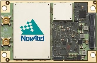
GPS-Aided INS-DM
                                                                                                Datasheet Revision 1.18
INS-DM Product Code Structure
         IMU                                            Encoder   Pressure           External     Data      GNSS
 Model          Gyro    Acc   Calibration   Connector                        Color                                    Version    Interface
         type                                           support    Ports             Compass     Logger    receiver
INS-DM    M1    G2000   A8       TGA           C71         E         0P        B       SAMC        S64       ZD9P      VD9        12345
          E1    G950    A15     TMGA           C72                   2P        G                            O7720                  1245
          A1    G450    A20                    C73                 2PEXT       D                                                    145
          N11   G400    A40
          B1

                Example: INS-DM-E1-G2000-A8-TGA-C71E-2P-B-SAMC-S64-ZD9P-VD9.12345

    • INS-DM: Dual Antenna GPS-Aided Inertial Navigation System
    • M1: Inertial Labs miniAHRS Attitude & Heading Reference System
    • E1: Inertial Labs KERNEL-110 IMU
    • A1: Inertial Labs KERNEL-210IMU
    • N11: Inertial Labs IMU-NAV-100
    • B1: Honeywell HG4930 CA51 IMU
    • G2000: Gyroscopes measurement range = ±2000 deg/sec
    • G950: Gyroscopes measurement range = ±950 deg/sec
    • G450: Gyroscopes measurement range = ±450 deg/sec
    • G400: Gyroscopes measurement range = ±400 deg/sec (using Honeywell HG4930 CA51 IMU)
    • A8: Accelerometers measurement range ±8 g
    • A15: Accelerometers measurement range ±15g
    • A20: Accelerometers measurement range ±20 g (using Honeywell HG4930 CA51 IMU)
    • A40: Accelerometers measurement range ±40 g
    • TGA: Calibration of IMU (Gyroscopes and Accelerometers) in operational temperature range
    • TMGA: Calibration of IMU (Magnetometers, Gyroscopes and Accelerometers) in operational temperature range
    • C71: two connectors (22 – main; 13 – auxiliary)
    • C72: C71 with MIL-STD-1275 protection
    • C73: MIL-STD-1275 protection, enclosure with asymmetrical alignment mounting holes
    • E: Encoder support
    • 0P: Zero Airspeed Pressure Ports (Total/Static)
    • 2P: Two Airspeed Pressure Ports with Standard Range (Total/Static, Honeywell 025MD)
    • 2PEXT: Two Airspeed Pressure Ports with Extended Range (Total/Static, Honeywell 600MD)
    • B: Black Color of enclosure (default)
    • G: Green Color of enclosure (optional)
    • D: Desert Tan Color of enclosure (optional)
    • SAMC: External Stand-Alone Magnetic Compass (optional)
    • S64: 64GB embedded Data Logger (optional)
    • ZD9P: dual uBlox ZED-F9P, Dual-Frequency, Multi-Constellation, RTK Capable GNSS Receiver
    • O7720: Novatel OEM7720 GNSS receiver
    • VD9: GPS L1/L2, GLONASS L1/L2, BEIDOU B1/B2, GALILEO E1/E5, QZSS L1/L5, DGPS, RTK, Dual antenna Heading,
      GNSS measurements, GNSS positions (Dual Antenna GNSS Receiver only)
    • .12345: RS-232, RS-422, RS-485 (for stand-alone magnetic compass only), CAN, Ethernet
    • .1245: RS-232, RS-422, CAN, Ethernet (in case of using internal datalogger)
    • .145: RS-232, CAN, Ethernet (in case of using internal datalogger + encoder)

                   Inertial Labs Address: 39959 Catoctin Ridge Street, Paeonian Springs, VA 20129 U.S.A.                     6
                                  Tel: +1 (703) 880-4222, Website: www.inertiallabs.com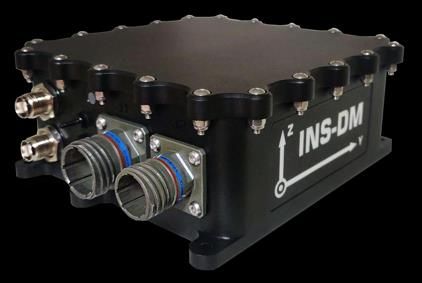
GPS-Aided INS-DM
                                                                                         Datasheet Revision 1.18
INS-DM mechanical and electrical interfaces description:

                                                                  Notes:
                                                                  1.   All dimensions are in millimeters
                                                                  2.   All pinouts and dimensions are subject to change without notice.
                                                                       For verification of validity of mechanical drawing please contact
                                                                       Inertial Labs Support.

       Drawing for
       enclosure with
       asymmetrical
       alignment
       mounting holes
       (version C73)

            Inertial Labs Address: 39959 Catoctin Ridge Street, Paeonian Springs, VA 20129 U.S.A.                         7
                           Tel: +1 (703) 880-4222, Website: www.inertiallabs.com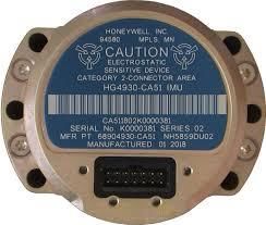
You can also read