Magnitude 7.5 PALU, INDONESIA - Friday, September 28, 2018 at 10:02:43 UTC - IRIS
←
→
Page content transcription
If your browser does not render page correctly, please read the page content below
Magnitude 7.5 PALU, INDONESIA
          Friday, September 28, 2018 at 10:02:43 UTC

A magnitude 7.5 earthquake occurred 80.8 km (50.2 mi)
north of Palu, Indonesia at a depth of 10 km (6.2 miles).
This earthquake triggered a tsunami with wave heights up
to 2 m (6.6 ft) that an official said swept away houses in
at least two cities.

The tsunami hit Palu, the capital of central Sulawesi
province (population 282,000), Donggala, and several
other coastal settlements.

Considerable damage is being reported, including many
people reported missing. Communications and power
have been disrupted.

                 Still image from a cell phone video of the tsunami wave
                        inundating Palu, Indonesia compounding damage
                          following the earthquake. Image courtesy BBC.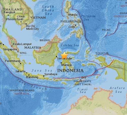
Magnitude 7.5 PALU, INDONESIA
           Friday, September 28, 2018 at 10:02:43 UTC

The Modified-Mercalli Intensity
scale is a twelve-stage scale,
from I to XII, that indicates the
severity of ground shaking.

The area nearest the
earthquake experienced violent
shaking.

                            Perceived
Modified Mercalli Intensity  Shaking
                           Extreme
                            Violent
                            Severe
                          Very Strong
                            Strong
                           Moderate
                             Light
                             Weak
                                             USGS Estimated shaking Intensity from M 7.5 Earthquake
                            Not Felt
Image courtesy of the US Geological Survey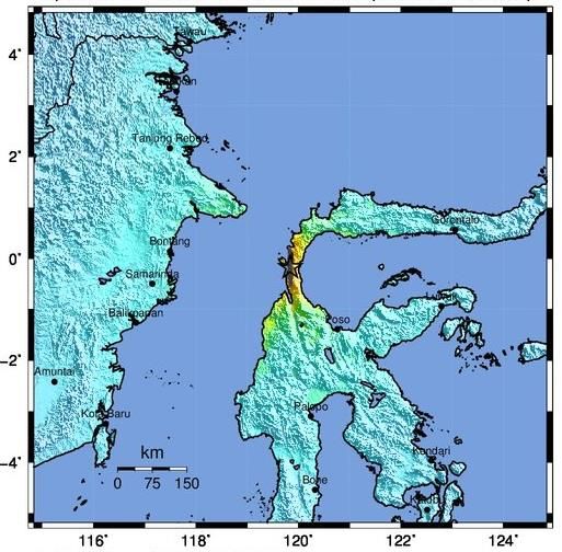
Magnitude 7.5 PALU, INDONESIA
          Friday, September 28, 2018 at 10:02:43 UTC
                                                                                   USGS PAGER
                                                        Population Exposed to Earthquake Shaking
The USGS PAGER map shows the
population exposed to different Modified
Mercalli Intensity (MMI) levels.

The USGS estimates that
approximately 10,000 people felt
violent shaking from this earthquake.

                                       The color coded contour lines outline regions of MMI intensity.
                                    The total population exposure to a given MMI value is obtained by
                                    summing the population between the contour lines. The estimated
                                     population exposure to each MMI Intensity is shown in the table.
                                                         Image courtesy of the US Geological Survey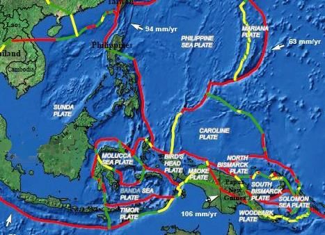
Magnitude 7.5 PALU, INDONESIA
          Friday, September 28, 2018 at 10:02:43 UTC

                                                       The Pacific, Philippine,
                                                       Eurasian and Australian
                                                       Plates meet in a complex
                                                       arrangement of subduction
                                                       zones in the western Pacific
                                                       Ocean.
                                                               Convergent plate boundary
                                                               Divergent plate boundary
                                                               Transform plate boundary

Image courtesy of the US Geological Survey

In detail, there are numerous
microplates (fragments of larger
plates) with convergent, divergent,
and transform (strike-slip)
boundaries between them.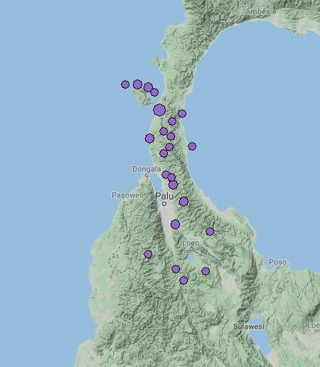
Magnitude 7.5 PALU, INDONESIA
              Friday, September 28, 2018 at 10:02:43 UTC

The Sunda Plate is the                   M7.5 Earthquake
southeastern promontory of the           Sept 28, 2018
Eurasian Plate. At the Sunda
Trench and the Timor Trough, the
Australia Plate subducts beneath
the Sunda Plate.                                           Sulawesi

Cross section D-D’ illustrates
subduction of oceanic lithosphere              SUNDA
at the northern edge of the                    PLATE
Australia Plate. As continental
lithosphere of the Australia Plate
approaches the Timor Trough, the
Australia – Sunda convergent
boundary is becoming a continental
collision zone. Australia – Sunda
plate convergence, along with
convergence between the Sunda
Plate and the Pacific and Philippine              SUNDA TRENCH
                                                                                    AUSTRALIA
Plates, is causing internal              INDIAN                                       PLATE
deformation of the Sunda Plate.          OCEAN

This earthquake occurred on an
intraplate strike-slip fault, possibly
on the Palu Fault.                                               Image courtesy of the US Geological Survey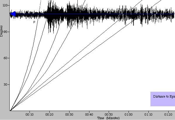
Magnitude 7.5 PALU, INDONESIA
Friday, September 28, 2018 at 10:02:43 UTC
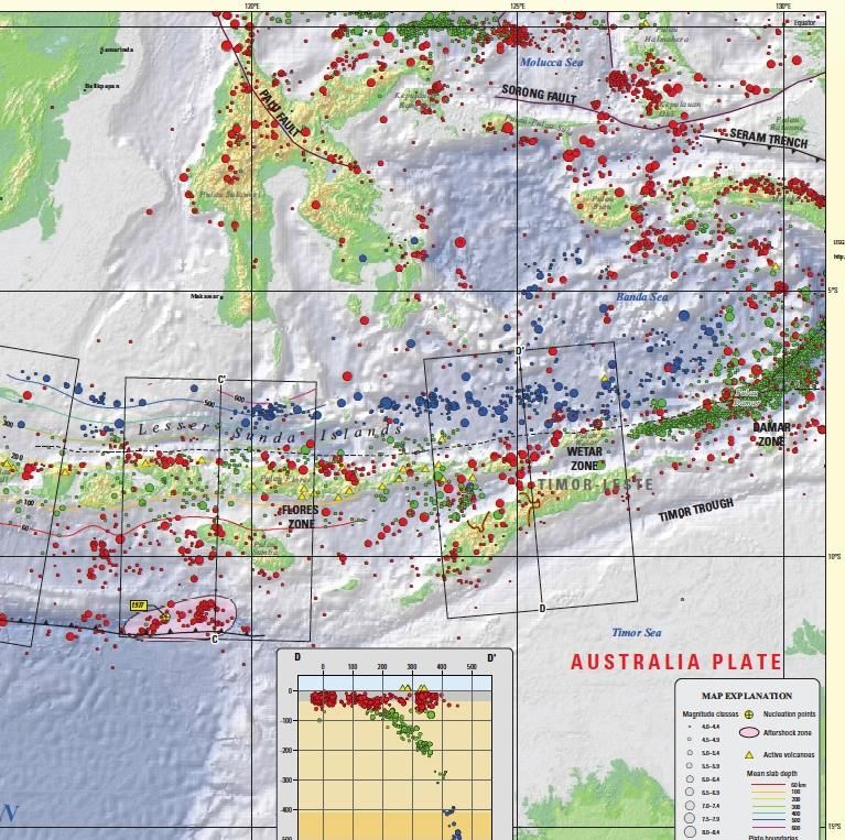
Regional historic seismicity in this
region is shown on the map with
earthquakes color coded by depth.
The pattern of earthquake depths
shows the complexity of the tectonic
setting. The shallow to deep trend in
earthquake depths in the NE portion M 7.5
of map is due to subduction of
Philippine Plate beneath the Sunda
Plate.
There have been 22 M7.5+
earthquakes recorded in the region
since 1900 due to the arc-continent
collision and the relative motions
between the numerous local
microplates.
Image from IRIS Earthquake Browser http://www.iris.edu/ieb
Magnitude 7.5 PALU, INDONESIA
         Friday, September 28, 2018 at 10:02:43 UTC

Earthquakes from September 28,
2018 are plotted to the right.

In the hours prior to this earthquake,
there were a series of small-to-
moderate sized earthquakes ranging                M 7.5
from M 4.6 – M 6.1. The M 6.1
occurred three hours earlier and just
to the south of the M 7.5 event.

In the three hours following this
earthquake, there have been ten
events of M 4.7 and larger. The
largest aftershock was a M 5.8, about
12 minutes after the M 7.5
earthquake.

Explore these earthquakes at:
https://bit.ly/2NP3SFY
                                     Images from IRIS Earthquake Browser http://www.iris.edu/ieb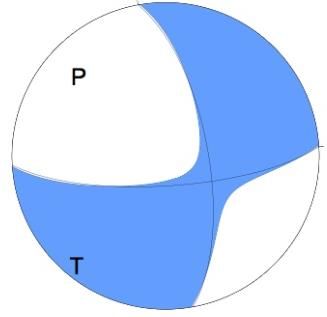
Magnitude 7.5 PALU, INDONESIA
           Friday, September 28, 2018 at 10:02:43 UTC

The focal mechanism is how seismologists plot the 3-D stress orientations of an
earthquake. Because an earthquake occurs as slip on a fault, it generates
primary (P) waves in quadrants where the first pulse is compressional (shaded)
and quadrants where the first pulse is extensional (white). The orientation of
these quadrants determined from recorded seismic waves identifies the type of
fault that produced the earthquake.

This earthquake occurred as the result of strike-slip faulting on a shallow crustal
fault within the interior of the Sunda Plate.

USGS WPhase Centroid Moment Tensor Solution
Magnitude 7.5 PALU, INDONESIA
Friday, September 28, 2018 at 10:02:43 UTC
The record of the earthquake in Bend, Oregon (BNOR) is illustrated below.
Bend is 12,277 km (7629 miles, 110.6°) from the location of this earthquake.
P
PP S Surface Waves
SS
There was no direct P wave arrival from this earthquake because it is within the P wave
shadow zone that extends from 104°to 140°. The first arriving seismic wave from the
Indonesia earthquake was the PP wave that began arriving 19 minutes and 6 seconds
after the earthquake occurred in Indonesia. PP waves are compressional waves that
bounce off the Earth’s surface halfway between the earthquake and the station.
There was no S wave arrival because the earthquake is within the S wave shadow zone
that includes all distances beyond 104°. SS waves are shear waves that followed the
same path through the mantle as PP waves and these wave began arriving 34 minutes
and 34 seconds after the earthquake occurred.
Surface waves, both Love and Rayleigh, traveled the 12,277 km (7629 miles)
along the perimeter of the Earth from the earthquake to the recording station.Teachable Moments are a service of
The Incorporated Research Institutions for Seismology
Education & Public Outreach
and
The University of Portland
Please send feedback to tkb@iris.edu
To receive automatic notifications of new Teachable Moments
subscribe at www.iris.edu/hq/retm
www.iris.edu/earthquakeYou can also read