SenseFly Camera Collection - A professional sensor for every application

Page created by Roland Tucker
 
CONTINUE READING
SenseFly Camera Collection - A professional sensor for every application
senseFly
Camera Collection
A professional sensor for
every application
SenseFly Camera Collection - A professional sensor for every application
Introducing
                                                                                                                                                                                                                  senseFly
                                                                                                                                                                                                                  S.O.D.A. 3D

                                                                                                                                                                                                                  3D mapping, redefined

                                                                                                                                 Image: senseFly S.O.D.A. 3D oblique image (left) merging into 3D mesh (right).

   • Stunning digital 3D reconstructions in vertically-focused
     environments such as urban areas, open pit mines and
     coastlines—over larger areas than quadcopters can achieve
   • Vast coverage over flat, homogenous terrain (up to 500
     ha / 1,235 ac per 122 m / 400 ft flight*)

   The senseFly S.O.D.A. 3D is a unique innovation—a
   professional drone photogrammetry camera that changes
   orientation during flight to capture three images (2 oblique,
   1 nadir) every time, instead of just one, for a much wider field
   of view. It is optimised for quick, robust image processing
   with Pix4Dmapper.
                                   * eBee X flight with Endurance Extension.

                                                                                                                                                                                                                  Suits:

                                                                                                                                                                                                                  • Urban mapping
      Sensor                      Lens                        Resolution              Formats          Exposure compensation
                                                                                                                                                                                                                  • Mine & quarry mapping
         1”                     F/2.8-11,                       20 MP            RGB: JPEG, DNG+JPEG     ±2.0 (1/3 increments)
        RGB                 10.6 mm (35 mm                  5,472 x 3,648 px                                                                                                                                      • Coastline mapping
                           equivalent: 29 mm)                     (3:2)
                                                                                                                                                                                                                  • Large area mapping over flat terrain

                                                                                                                                                                                                                  Compatible with:

      Shutter               White balance                      ISO range                 FOV              Direct In-Flight                                                                                        • eBee X
                                                                                                       Georeferencing (DIFG)
        Global             Auto, sunny, cloudy,            125-6400 (sensor)        Total FOV: 154°
1/30–1/2000s (sensor)             shady                        125-1600               64° optical
                                                                                                                                     senseFly S.O.D.A. 3D’s wide field of view ensures excellent 3D results in
    1/500–1/2000s                                          (user-configurable)      90° mechanical                               vertically-focused environments or vast mapping coverage over flat terrain.
  (user-configurable)
SenseFly Camera Collection - A professional sensor for every application
Smart Exposure technology                                                                                                                                                                                   Meet the
 • Optimised exposure time suits numerous
                                                                                                                                                                                                             senseFly
  light conditions, including low-light
 • Super sharp, rarely over-exposed images
                                                                                                                                                                                                             Aeria X
 • Minimal risk of noise & motion blur

                                                                                                                                                                                                             The compact marvel of
                                                                                                                                                                                                             drone photogrammetry

                                                                                                                                                     Image: senseFly Aeria X orthomosaic (1 cm/0.4 in GSD)

  The senseFly Aeria X is a compact drone photogrammetry
  powerhouse.                                                                       Direct In-Flight
                                                                                 Georeferencing (DIFG)
  This rugged innovation offers the perfect blend of
  size, weight and DSLR-like image quality. It offers
  stunning image detail and clarity, in virtually all light            • Records the GPS position and exact orientation
  conditions, allowing you to map for more hours per day                of senseFly Aeria X at each capture location
  than ever before.                                                    • Less image overlap is required, enabling greater
                                                                        flight coverage and quicker image processing
  Its built-in Direct In-Flight Georeferencing meanwhile
                                                                       • Improved reconstructions over difficult
  boosts your efficiency even further by lowering the
                                                                        environments (water, forests etc.)
  amount of image overlap required—for greater coverage
  and quicker post-flight image processing.

                                                                                                                                                                         z                                   Suits:

                                                                                                                                                                                                             • Surveying & cadastre
      Sensor                     Lens              Resolution                   Formats            Exposure compensation                                                                                     • Topographic mapping
                                                                                                                                                                                   y
       APS-C                   F/2.8-16,             24 MP                RGB: JPEG, DNG+JPEG         ±2.0 (1/3 increments)                              x                                                   • Site digitisation
        RGB                18.5mm (28mm          6,000 x 4,000 px
                                                                                                                                                                                                             • Volume measurement
                          equivalent: 35 mm)           (3:2)
                                                                                                                                                                                                             • Inspection

                                                                                                                                                                                                             Compatible with:
      Shutter              White balance            ISO range                      FOV                Direct In-Flight                                                                                       • eBee X
                                                                                                   Georeferencing (DIFG)
        Global            Auto, sunny, cloudy,   100-6400 (sensor)             75° (diagonal)
1/30–1/4000s (sensor)            shady               100-3200                   HFOV: 64°
    1/500–1/2000s                                (user-configurable)                                                          Direct In-Flight Georeferencing automatically records the GPS position
                                                                                                                                               and orientation of the camera at each capture location.
  (user-configurable)
SenseFly Camera Collection - A professional sensor for every application
Presenting
                                                                                                                                                                                                                          senseFly
                                                                                                                                                                                                                          Duet T

                                                                                                                                                                                                                          2 sensors,
                                                                                                                                                                                                                          1 heat map star
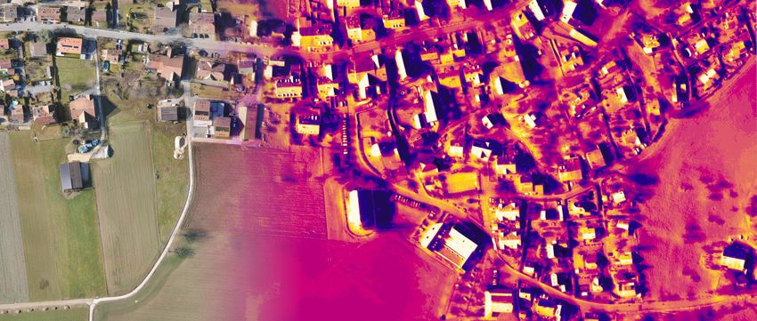
                                                                                                                                Image: senseFly Duet T RGB orthomosaic (left) merging into thermal orthomosaic (right).

The senseFly Duet T is a rugged dual-camera thermal
mapping rig. Use it to create geo-accurate thermal maps
and digital surface models quickly and easily.

The Duet T includes a high-resolution thermal infrared
(640 x 512 px) camera and a senseFly S.O.D.A. RGB
camera. Both image sources can be accessed as and
when required, while the rig’s built-in Camera Position
Synchronisation feature works in sync with Pix4Dmapper
photogrammetry software (optional) to simplify the map
reconstruction process.

                                                                                                                                                                                                                          Suits:

                                                                                                                                                                                                                          • Solar panel inspection
                                                                                                                                                                                                                          • Irrigation planning & analysis
              Sensors                       RGB lens                   Thermal lens                 Resolution
                                                                                                                                                                                                                          • Animal management (e.g. counting
       Thermal infrared (FLIR):              F/2.8-11,                     F/1.25,           Thermal: 640 x 512 px (5:4)
        (10.9 mm x 8.7 mm)               10.6 mm (35 mm               13 mm (35 mm           RGB: 5,472 x 3,648 px (4:3)                                                                                                    & detection)
              RGB: 1”                   equivalent: 29 mm)           equivalent: 40 mm)
                                                                                                                                                                                                                          • Heat tracking & leak detection
                                                                                                                                                                                                                          • Environmental monitoring

                                                                                                                                                                                                                          Compatible with:
        Shutter                      Formats                      IMU                     Thermal FOV               RGB FOV
 Thermal: rolling, 30 Hz          Thermal: R-JPEG            Synchronized IMU               HFOV:45.4°
                                                                                           HFOV:  45°               HFOV: 64°                                                                                             • eBee X
     RGB: Global                     RGB: JPEG                                              VFOV:37.0°
                                                                                           VFOV:  37°               VFOV: 37°
   1/500–1/2000s                                                                            DFOV:56.4°
                                                                                           DFOV:  56°               DFOV: 74°           senseFly Duet T concurrently captures RGB data and thermal infrared data,
                                                                                                                                                                    including a temperature reading for each pixel.
SenseFly Camera Collection - A professional sensor for every application
Here’s the
                                                                                                                                                                                                                        MicaSense
                                                                                                                                                                                                                        RedEdge-MX

                                                                                                                                                                                                                        The sensor that
                                                                                                                                                                                                                        doesn’t compromise
                                                                                                                    Image: MicaSense RedEdge-MX RGB orthomosaic (left) merging into chlorophyll index output (right).

The RedEdge-MX is a rugged and precise multispectral
sensor for advanced agricultural analysis. It captures
both the spectral bands required for crop health indices
and an additional blue band for deeper insights into
specific issues.

The RedEdge-MX features an optimised GSD of 8 cm
(3.1 in) per pixel at 120 m / 400 ft, composite RGB color
images, a global shutter for distortion-free captures and
an additional light sensor (DLS 2) for highly-accurate
radiometric calibration, making the RedEdge-MX one of
the most powerful crop sensors on the market.

                                                                                                                                                                                                                        Suits:
                                                                                                                                                                               DLS 2 sensor
                                                                                                                                                                                                                        • Plant health analysis
          Sensor                 Multispectral sensor               Single-band resolution                Formats
                                                                                                                                                                               RedEdge-MX                               • Agricultural research / field trials
         Five band                      Five-band                              1.2 MP                      TIFF
                                                                                                                                                                                                                        • Emergence tracking
  multispectral sensor: 1/3”                                               1,280 x 960 px
                                                                                (4:3)                                                                                                                                   • Disease monitoring
                                                                                                                                                                                                                        • Definition of management zones
                                                                                                                                                                                                                        • Fertiliser/input planning & optimisation

                   Shutter                  Multispectral bands
                                     White balance           ISO range                  Single-band FOV                                                                                                                 Compatible with:
                    Global                    Blue (475 nm ± 20 nm)Auto
                                           Auto                                             HFOV: 47°
                                             Green (560 nm ± 20 nm)                         VFOV: 37°
                                              Red (668 nm ± 10 nm)                          DFOV: 58°                                                                                                                   • eBee X
                                            Red edge (717 nm ± 10 nm)
                                          Near infrared (840 nm ± 40 nm)
SenseFly Camera Collection - A professional sensor for every application
This is
                                                                                                                                                                                Parrot
                                                                                                                                                                                Sequoia+
                                                                                                                                                                                Capture the invisible

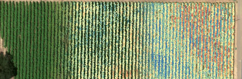
                                                                                                                                              Image: Parrot Sequoia+ NDVI map

   The Parrot Sequoia+ is the most popular multispectral
   sensor in agriculture. This lightweight, adaptable and
   value-packed solution features two types of sensor for
   the price of one: four multispectral 1.2 MP sensors, with
   global shutters, and RGB, plus a sunshine sensor.

   When used with Pix4D software, the Sequoia+ is the first
   multispectral camera to provide absolute reflectance
   measurements without the need for a radiometric calibra-
   tion target. The Sequoia+ is also the only crop sensor to
   support RTK/PPK workflows for precise georeferenced
   results. And it offers the largest single-flight coverage of
   any sensor in its class (nominal coverage of 200 ha / 494
   ac with an eBee SQ flown at 120 m / 400 ft).

                                                                                                                                                                                Suits:
                                                                                                                                                  Sunshine sensor
                                                                                                                                                                                • Plant health analysis
       Sensors
       Sensors               Multispectral sensor         RGB resolution        Single-band resolution           Multispectral bands                                            • Emergence tracking
                                                                                                                                                  Sequoia+
  Multispectral
Multispectral   sensor1/3”
              sensor:             Four-band                   16 MP                        1.2 MP               Green (550 nm ± 40 nm)                                          • Disease monitoring
(4.8RGB  camera:
     x 3.6 mm) 1/2.3”
                   RGB                                    4,608 x 3,456 px             1,280 x 960 px            Red (660 nm ± 40 nm)
         camera                                                (4:3)                        (4:3)             Red edge (735 nm ± 10 nm)                                         • Definition of management zones
                                                                                                             Near infrared (790 nm ± 40 nm)                                     • Fertiliser/input planning & optimisation

                                                                                                                                                                                Compatible with:

                                                                                                                                                                                • eBee X, eBee SQ, eBee Plus, eBee Classic
               Single-band shutter            RGB shutter                    RGB FOV                    Single-band FOV
                       Global                   Rolling             HFOV: HFOV:
                                                                          63.9° 64° VFOV:                 HFOV: 61.9°
                                                                                                          HFOV: 62°
                                                 6 Hz               50.1° VFOV:DFOV:
                                                                                50° 73.5°                 VFOV: 48.5°
                                                                                                          VFOV: 49°
                                                                          DFOV: 74°                       DFOV: 73.7°
                                                                                                          DFOV: 74°
SenseFly Camera Collection - A professional sensor for every application
senseFly                                                                                                                                                                  senseFly
S.O.D.A.                                                                                                                                                                  Corridor
The sensor optimised for                                                                                                                                                  Linear mapping
drone applications                                                                                                                                                        made easy

                                                             Image: senseFly S.O.D.A. orthomosaic   Image: senseFly S.O.D.A. Corridor orthomosaic

                                              The   senseFly    S.O.D.A.    is   the   first              senseFly Corridor is a combined senseFly
                                              camera to be built for professional                         S.O.D.A./eMotion software solution that
                                              drone photogrammetry and has quickly                        makes corridor mapping easy. With
                                              become the reference sensor in its field. It                its portrait camera position, senseFly
                                              captures amazingly sharp aerial images,                     Corridor requires 30% fewer images to
                                              across light conditions, with which to                      map the same linear route. This, in turn,
                                              produce detailed, vivid orthomosaics and                    means 30% shorter processing times.
                                              ultra-accurate 3D digital surface models.

Suits:

• Surveying & cadastre
• Topographic mapping                                                                                                                                                     Suits:
• Site digitisation                       Sensor                        Lens                                            Formats                        Resolution
• Volume measurement                         1”                      F/2.8-11,                                   RGB: JPEG, DNG+JPEG                 5,472 x 3,648 px     • Planning, design & analysis of linear
                                            RGB                  10.6 mm (35 mm                                                                            (3:2)            infrastructure
• Inspection
                                                                equivalent: 29 mm)
• Plant counting                                                                                                                                                          • River & coastline mapping

• Irrigation design

Compatible with:                                                                                                                                                          Compatible with:
                                          Shutter                 White balance                              Exposure compensation                     ISO range

• eBee X, eBee Plus, eBee Classic           Global              Auto, sunny, cloudy,                            ±2.0 (1/3 increments)               125-6400 (sensor)     • eBee X, eBee Plus
                                    1/30–1/2000s (sensor)              shady                                                                            125-1600
                                        1/500–1/2000s                                                                                               (User-configurable)
                                      (User-configurable)
SenseFly Camera Collection - A professional sensor for every application
Compare
                cameras
                                              senseFly S.O.D.A. 3D            senseFly Aeria X            senseFly Duet T            MicaSense RedEdge-MX                  Parrot Sequoia+               senseFly S.O.D.A.          senseFly Corridor

                                                          1”                         APS-C             Thermal infrared (FLIR) and             Five band                 Multispectral sensor and                 1”                         1”
                Sensor                                   RGB                          RGB               RGB (senseFly S.O.D.A.)           multispectral sensor                 RGB camera                        RGB                        RGB
                                              F/2.8-11, 10.6 mm (35 mm      F/2.8-16, 18.5 mm (28 mm   F/2.8-11, 10.6 mm (35 mm                                                                        F/2.8-11, 10.6 mm (35 mm   F/2.8-11, 10.6 mm (35 mm
                RGB lens                          equivalent: 29 mm)            equivalent: 35 mm)         equivalent: 29 mm)
                                                                                                                                                   --                               --
                                                                                                                                                                                                           equivalent: 29 mm)         equivalent: 29 mm)
                                                        20 MP,                       24 MP,                      20 MP,                                                          16 MP,                         20 MP,                     20 MP,
                RGB resolution                   5,472 x 3,648 px (3:2)       6,000 x 4,000 px (3:2)      5,472 x 3,648 px (3:2)
                                                                                                                                                   --
                                                                                                                                                                          4,608 x 3,456 px (4:3)         5,472 x 3,648 px (3:2)     5,472 x 3,648 px (3:2)

                Exposure compensation           ±2.0 (1/3 increments)         ±2.0 (1/3 increments)                 --                             --                               --                   ±2.0 (1/3 increments)      ±2.0 (1/3 increments)

                                                       Global                        Global                     Global                                                                                          Global                     Global
                RGB shutter                        1/30 - 1/2000 s               1/30 - 1/4000 s            1/30 - 1/2000 s
                                                                                                                                                 Global                       Rolling, 6 Hz
                                                                                                                                                                                                            1/30 - 1/2000 s            1/30 - 1/2000 s
RGB

                                                     Auto, sunny,                  Auto, sunny,                Auto, sunny,                                                                                   Auto, sunny,               Auto, sunny,
                White balance                       cloudy, shady                 cloudy, shady               cloudy, shady
                                                                                                                                               Automatic                       Automatic
                                                                                                                                                                                                             cloudy, shady              cloudy, shady

                ISO range                             125-6400                      100-6400                    125-6400                      Automatic                        Automatic                       125-6400                   125-6400

                                                   Total FOV: 154°,               HFOV: 65°,                  HFOV: 64°,                                                      HFOV: 64°,                     HFOV: 64°,                 HFOV: 45°,
                RGB FOV                       64° optical, 90° mechanical     VFOV: 46°, DFOV: 75°        VFOV: 45°, DFOV: 73°
                                                                                                                                                   --
                                                                                                                                                                          VFOV: 50°, DFOV: 74°           VFOV: 45°, DFOV: 73°       VFOV: 64°, DFOV: 73°

                RTK/PPK support                          Yes                           Yes                         Yes                            No                          Yes (eBee X)                        Yes                        Yes

                Operating temperature                -10°C - 40°C                 -10°C - 40°C                -10°C - 40°C                     0°C - 60°C                           --                       -10°C - 40°C               -10°C - 40°C

                                                                                                         F/1.25, 13 mm (35 mm
                Thermal lens                               --                           --
                                                                                                           equivalent: 40 mm)
                                                                                                                                                   --                               --                             --                         --

                Thermal resolution                         --                           --                 640 x 512 px (5:4)                      --                               --                             --                         --
Thermal-IR

                Thermal shutter                            --                           --                   Rolling, 30 Hz                        --                               --                             --                         --

                IMU / DIFG                               DIFG                         DIFG                 Synchronized IMU                        --                               --                             --                         --

                                                                                                              HFOV: 45°,
                Thermal FOV                                --                           --
                                                                                                          VFOV: 37°, DFOV: 56°
                                                                                                                                                   --                               --                             --                         --

                Multispectral sensor                       --                           --                          --                          5-band                           4-band                            --                         --

                                                                                                                                                1.2 MP,                          1.2 MP,
                Single-band resolution                     --                           --                          --
                                                                                                                                          1,280 x 960 px (4:3)             1,280 x 960 px (4:3)
                                                                                                                                                                                                                   --                         --

                                                                                                                                         Blue (475 nm ± 20 nm)
                Multispectral bands                                                                                                     Green (560 nm ± 20 nm)
                                                                                                                                                                         Green (550 nm ± 40 nm)
Multispectral

                                                                                                                                                                          Red (660nm ± 40 nm)
                                                           --                           --                          --                   Red (668 nm ± 10 nm)                                                      --                         --
                                                                                                                                                                       Red edge (735nm ± 10 nm)
                                                                                                                                      Red edge (717 nm ± 10 nm)
                                                                                                                                                                      Near infrared (790 nm ± 40 nm)
                                                                                                                                     Near infrared (840 nm ± 40 nm)

                Single-band shutter                        --                           --                          --                          Global                            Global                           --                         --

                                                                                                                                             HFOV: 47°,                       HFOV: 62°,
                Single-band FOV                            --                           --                          --
                                                                                                                                         VFOV: 37°, DFOV: 58°             VFOV: 49°, DFOV: 74°
                                                                                                                                                                                                                   --                         --

                                                                                                                                           DLS 2 and included             Automatic radiometric
                Calibration                                --                           --                          --
                                                                                                                                      Calibrated Reflectance Panel             calibration
                                                                                                                                                                                                                   --                         --

                Formats       RGB                 JPEG, DNG+JPEG               JPEG, DNG+JPEG                     JPEG                             --                             JPEG                    JPEG, DNG+JPEG             JPEG, DNG+JPEG

                              Thermal                      --                           --                       R-JPEG                            --                               --                             --                         --

                              Multispectral                --                           --                          --                           TIFF                             TIFF                             --                         --

                                                                                                                                                                            eBee X, eBee SQ,              eBee X, eBee Plus,
                Compatible with                         eBee X                       eBee X                      eBee X                         eBee X
                                                                                                                                                                         eBee Plus, eBee Classic            eBee Classic
                                                                                                                                                                                                                                      eBee X, eBee Plus
SenseFly Camera Collection - A professional sensor for every application
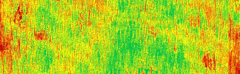
Explore the datasets: www.senseFly.com/datasets

                 For more information: www.senseFly.com/cameras

At senseFly, we believe in using technology to make work safer and more efficient. Our
proven drone solutions simplify the collection and analysis of geospatial data, allowing
professionals in surveying, agriculture, engineering and humanitarian aid to make better
   decisions, faster. senseFly was founded in 2009 and quickly became the leader in
   mapping drones. The company is a commercial drone subsidiary of Parrot Group.
                                                                                           EN - 2019
SenseFly Camera Collection - A professional sensor for every application
You can also read