Transportation Topics and Tales: Milestones in Transportation History in Southern California - By John E. Fisher, P.E. PTOE
←
→
Page content transcription
If your browser does not render page correctly, please read the page content below
Transportation Topics and Tales:

Milestones in Transportation History

       in Southern California

       By John E. Fisher, P.E. PTOE
Transportation Topics and Tales                                                                                                                                                          Introduction

      hortly after I joined ITE (Institute of Transportation Engineers) in 1972, I purchased the ITE publica-
      tion, Traffic Devices, Historical Aspects, Thereof. While this publication was rich with traffic device
 history on the East Coast and Mid-West, there was little history regarding traffic control in the Southern
 California.
                                                                                                                             Later, in 1987, I came across a 1937                     ³
                                                                                                                             photograph of a prominent intersec-
                                                                                                                             tion in Los Angeles. It was Wilshire       Did you know Los An-
                                                                                                                             Boulevard and Western Avenue, which geles was the home of
                                                                                                                             was claimed to be the busiest intersec- the first pedestrian ac-
                                                                                                                             tion in the world, with 41,000 vehi-       tivated signal?
                                                                                                                             cles during the peak eight hours (a                      µ
                                                                                                                             1929 count). Certainly, the vintage
                                                                                                                             cars and well-dress shoppers of the
                                                                                                                             time provided an interesting contrast with the casual look and the rela-
                   1971 ITE P ublication of                                                                                  tively indistinctive cars of today. But what really caught my eye was the
                   Traffic Devices: Histori-                                                                                 traffic control–a diamond shaped Stop sign and off-center lane treat-
                   cal Deices Thereof
                   Graphic—8094
                                                                                                                             ment.
                                                                                                                             To find out more about this intriguing traffic control, I contacted re-
                                                                                                                             tired Assistant General Manager, Hugh Gilman, who had worked with
                                                                                                                             pioneering Los Angeles traffic engineer, Ralph Dorsey. Gilman’s rec-
                                                                                                                             ollections led me to the City archives, old magazine articles, and even-
                                                                                                                             tually to a meeting with Ralph Dorsey’s son, Frank. Frank gave me his
                                                                                                                             father’s 32 years of saved newspaper clippings relating to traffic con-
                                                                                                                             trol, spanning the years 1922 to 1954.

                                                                                                                             This multitude of clippings turned out to be a treasure chest of infor-
   Wilshire Boulevard at Western Ave-                                                                                        mation which traces the history of transportation and traffic control
   nue, 1937                                                                                                                 in Southern California. As I assembled photos and written informa-
   Graphic—5037                                                                                                              tion over the years from old-timers, old publications and vintage docu-
                                                                                                                             ments, I began to see how, in many cases, Southern California and Los
                                                                                                                             Angeles in particular were in the national forefront in traffic engineer-
                                                                                                                             ing. Los Angeles had the busiest intersections in the world, the first
                                                                                                                             interconnected signal system, the first simplified traffic code and the
                                                                                                                             first pedestrian activated signal.

    L eft t o right : F rank D o rs e y, son o f pion e erin g tra f fic en g in ee r R alph D o rs ey; D ea n e T e r ry,
    t h e first pers on w it h a n en gine ering d egre e in t he L os Ange les T r aff ic D e p art m e nt ; a nd
    H u gh G ilm an, th e firs t p ers o n w ith any de gree in t h e Lo s An gele s T raf fic D ep a rt m en t .

    G raphic - 31 28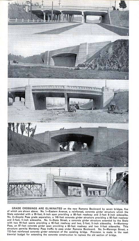
Table of Contents

 Introduction: Transportation Topics & Tales      Traffic Regulations
 Table of Contents                                The First Simplified Traffic Code
 Rail Transit                                     Pedestrian Regulation
 The Beginning of Motorized Transportation in     Los Angeles' First Traffic Engineer
      Southern California                         The Evolution of Traffic Management in the City
 Los Angeles and the Transcontinental Railroads   The Origin and Evolution of the Department of
 Early Transit Systems in Los Angeles                  Transportation
 The Yellow Cars and Red Cars                     The Headquarter Sites of LADOT
 The Evolution of Public Transit in Los Angeles   The Origin and Evolution of Traffic Officers
 The Angels Flight Story                          Traffic Control Signs
 The Funicular Transit Systems                    The Origin of Traffic Control Signs
 The Creation of Commuter Rail in Southern        The California Stop Sign
      California                                  Freeway Guide Signing
 Standard Railroad Gauge                          Safety Slogan Signs
 Jitneys - A Recurring Idea                       Street Name Signs
 Roadways                                         Parking
 The City's First Road                            The First Parking Meters
 The El Camino Real Bells                         Off-Street Parking
 The Roots of Our Routes
                                                  Pavement Markings
 The Main Street of America
                                                  Mushrooms, Dots, Gaps and Tracks
 Figueroa Street - A Preview of the Future
                                                  Left-Turn Pockets
 7th Street and Broadway
                                                  The Development of the Two-Way Left-Turn Lane
 The 5th Avenue of the West
                                                  Reversible Lanes
 The Street That's a "10"
                                                  Traffic Signal Control
 Bridges & Tunnels
                                                  The Acme and Other Vintage Traffic Signals
 The City's River Bridges
                                                  Pedestrian Push Buttons
 Pedestrian Tunnels
                                                  Mid-Block Pedestrian Traffic Signals
 Street Lighting                                  Mastarm Signals
 Enlightened Street Lighting                      Uniquely Signalized Driveways
                                                  The Smart Pedestrian Warning Device
 Freeways
 Ramona Boulevard - The Airline Route             Traffic Signal Timing
 The Freeways Built By the City                   The Evolution of Left-Turn Phasing in the
 Arroyo Seco Parkway                                   Los Angeles Area
 Cahuenga Parkway                                 Sabbath Signal Timing
                                                  Early Methods for Traffic Signal Network Timing
 Transportation Planning
                                                  Computer Signal System Control in Southern
 The City's First Transportation Plan
                                                       California
 The Origin of the County Street System
                                                  Traffic Signal Control Centers
 Land Use Zoning and Decentralization
 Regional Transportation Planning
The Beginning of Motorized Transport in Southern California                                                         Transit

     ince the beginning of recorded history, the human race has depended on animals - horses, mules, camels and
     oxen - for long distance transportation across land. Such was the case in Southern California. Los Angeles and
 other settlements along El Camino Real were accessible only by horseback and stagecoach. That would begin to
 change with the efforts of a person who would become known as the “King of Transportation,” Phineas T. Banning.
 Banning was a mule skinner, stagecoach driver and entrepreneur in a
 freight transportation company after arriving in San Pedro in 1851. He
 built trade routes to Ft. Tejon, Yuma, Tucson, and Salt Lake City and
 used his San Pedro wharf as the base for his shipping business.                   Did you know Phineas T.
                                                                                   Banning was known as
 Soon he would achieve greater successes. When a storm ripped apart his
 San Pedro wharf in 1857, he built a new one a few miles to the south. He          the King of Transporta-
 then transformed a marsh land, known as “Goose Town,” into a shipping             tion?
 wharf at the end of what is now Avalon Boulevard. Around that wharf, he
 carved out a town that he would call New San Pedro. He would later re-
 name it Wilmington, after the capital of his home state of Delaware.
 In 1865, he began two two-year terms to the State Senate and was focused on seeking funds to build Los Angeles’
 first railroad. In the grander scheme of things, he believed that a railroad would revive Los Angeles after the national
 economic collapse resulting from the Civil War. But on the personal level, he would greatly gain from this effort to
 transport goods from the Wilmington wharf to the young city along the “river on wheels.” His bill passed the Leg-
 islature in 1868 and a $225,000 bond for the San Pedro and Los Angeles Railroad was approved by Los Angeles
 voters by a mere 28-vote margin. Conflict of interest notwithstanding, Banning was a major stockholder in the rail-
 road and was awarded the construction contract.

 On October 26, 1869, the first railway in Southern California opened along the 22-mile Dominguez Route ending
 at what is now Commercial Street. In 1873, the line was sold to Southern Pacific to entice them to extend the na-
 tional rail network from San Francisco to Los Angeles. This linkage was realized in 1876.

 Soon thereafter, Banning improved the wharf into a deep water port where large seagoing steamers would dock. Ban-
 ning’s seaport was eventually absorbed by the Port of Los Angeles and the “King of Transportation” also would be-
 come known as the “Father of the Los Angeles Harbor.” The linkage of the City with the national rail network, the
 development of the wharf into a harbor and the accessibility between these two points was the catalyst which acti-
 vated the transformation of Los Angeles from a dusty pueblo to a major metropolis.
 During the automobile era, a road was built alongside the Dominguez Route
 and is now known as Alameda Street. Due to the growth of the County,
 numerous grade crossings were added thus resulting in collisions, delay and         The first railway in South-
 deteriorated freight operation. In April 2002, the Alameda Corridor was             ern California opened in
 completed which rebuilt Banning’s railroad below the street network. This           1869.
 national model of freight transportation permanently reaffirmed Banning’s
 vision of a “river on-wheels.”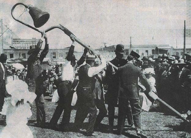
Los Angeles and the Transcontinental Railroads                                                             Transit

      n 1869, railroad workers drove the Golden Spike in Promontory, Utah, joining the Union Pacific and
      Southern Pacific railroads into a continuous transcontinental route. Later that year, Phineas T. Banning
 built the first railroad in Southern California between Downtown Los Angeles and San Pedro. From those
 accomplishments arose the vision of connecting Los Angeles to the rest of the nation via the new rail net-
 work.
                                     In 1873, Bannings’ railroad was sold to
                                     Southern Pacific to entice it to extend its
                                     line southerly from San Francisco. That Did you know that Los Ange-
                                     vision would be realized on September 5, les was connected to the
                                     1876 when the Golden State’s own golden transcontinental railroad
                                                                                  network in 1876.
                                     spike connecting Northern and Southern
                                     California was driven at Lang Station in
                                     what is now Santa Clarita. The first
                                    station was sited at the “cornfields” southerly of the junction of the Los
                                    Angeles River and the Arroyo Seco. In 1888, the SP moved to the Arcade
                                    Station on what is now Central Avenue at 5th Street. Later, it moved to an
                                    adjoining site to a station known as Central Station.
                                    The Atchison, Topeka and Santa Fe railroad reached Los Angeles in 1885.
   Graphic - 1022
                                    In 1893, it opened its stylish Moorish station called La Grande on what is
 Graphic 1022                       now Santa Fe Avenue between 1st and 2nd Streets.
 The third and final railroad, the Los Angeles Terminal Railway, reached Los Angeles in 1891. It was eventu-
 ally sold to Union Pacific. Its station was located on 1st Street just east of the Los Angeles River. The station
 burned down in 1924 and Union Pacific relocated to Central Station.

 As the City grew, the rail lines would share the right-of-way used by trolleys and automobiles. In 1915, after
 years of conflicts and fatal accidents, discussions got underway regarding a joint terminal and new track loca-
 tion. This resulted in a decade-long court battle. Finally, the presidents of the three railroads agreed and vot-
 ers approved a new joint (union) station in 1926. Finally, on May 3, 1939, Union Station opened its doors.
 This station, with mission revival architecture and streamline modern interior design elements, featured ornate
 52-foot ceilings, hardwood waiting-room chairs, giant chandeliers, decorative tiles, two courtyards and the
 grand Harvey House restaurant. Soon 64 passenger trains a day were passing through with romantic names
 like the Chief, Super Chief, Sunset Limited, Lark, Golden State, Desert Wind and the City of Los Angeles.

 However, as jet travel became available in the 1960's, passenger train travel at Union Station declined rapidly
 to just seven-passenger trains per day. In addition, long distance trucking impacted the railroad’s freight busi-
 ness. In 1967, the Harvey House restaurant closed and in 1971 Amtrak took over passenger operations.

 But today, Union Station again is Southern California’s primary transportation hub with Amtrak, Metrolink,
 the Metro Red Line, the Metro Gold Line, taxicabs, and bus lines converging on it daily. It serves as a symbol
 and reminder of the rail transportation network connections of the late 19th Century which transformed Los
 Angeles from a town of 10,000 to the center of the nation’s second largest metropolitan area.
Early Transit Systems in LA                                                                               Transit

     n 1869, Phineas Banning completed the first railway between Downtown Los Angeles and the San Pedro
     wharf. In 1872, Los Angeles County voters approved a measure to subsidize the construction of the
 Southern Pacific line to Los Angeles. It would arrive four years later.
 Citizens then turned their attention to local transportation. What would
 emerge was a succession of railways powered by horses, cables and then elec-
 tricity.
                                                                              The first horse-car
                                                                                 lines on railroad tracks
 Franchises for the first two horse-car lines on railroad tracks were granted in began operating in
 1874. The “Sixth and Spring” line, 2-1/2 miles long, began operation that 1874.
 year, followed by the “Main Street” line in 1875. This line would last until
 1897.
 Meanwhile, in San Francisco, a manufacturer of steel cables, long used in the mining industry, was developing
 new uses. One was for the ski lift. The other was for transporting a car up the steep, inclined streets of San
 Francisco. The first one began operation August 1, 1873 along Clay Street. The system involved a large
 steam engine in a conveniently located power house which was able to pull the cable.
                                        The concept eventually reached Los Angeles. On October 8, 1885,
                                        the Second Street Cable Railroad began operation and was built pri-
                                        marily to sell lots west of the Downtown area. As soon as the lots
 The Second Street Cable                were sold, the system was allowed to deteriorate and was abandoned
 Railroad began operation               four years later. Other cable lines included the Temple Street Cable
                                        Railway and the Los Angeles Cable Railway, later known as the Pacific
 in 1885.
                                        Railway Company. By 1891, the Pacific Railway Company operated
                                        over 20 miles of line. However, by 1893, its cable operation was dis-
                                        continued. The Temple Street line lasted until 1902.

 The first experiment with overhead electric lines occurred on January 1, 1887. It ran along Pico Boulevard to
 a real estate development. It was unsuccessful and was replaced by horse cars. However, the generation and
 reliability of electrical power underwent rapid improvement and by the beginning of the 20th century there
 would be electric lines running to the beaches, Pasadena and other population clusters. Electric lines would
 become the primary form of transit for the next half century.
Yellow Cars and Red Cars                                                                                Transit

     he Red Cars and Yellow Cars comprised the world’s largest inter-urban railroad system and shaped Southern
     California in the early part of the 20th century. Both were the entrepreneurial efforts of Henry Huntington.
                                   Henry was the nephew of Collis P.                                “Safety Zone”
                                   Huntington, who helped develop the                               for street-
                                   Southern Pacific Railroad. In 1895,                              running
                                                                                                    Yellow Cars
                                   Henry developed the first segment
                                   of the Los Angeles Railway (LARy),                               Graphic- 6013
                                   a narrow gauge (3' 6") line. The
                                   original line ran from Downtown
                                   Los Angeles to Pasadena. LARy
 Yellow Car near Lincoln Park      provided mostly local service to the
                                   developed communities and business
 Graphic - 6011
                                   districts adjacent to and near Downtown Los Angeles. The cars were
                                   painted yellow and generally operated in the middle of streets where patrons
                                   would board from narrow islands within the street.
                                   Henry Huntington then proceeded to develop the Pacific Electric Railway
                                   (PERy). Huntington purchased 72 separate local lines, most of them with
                                   narrow gauge track. He rebuilt them to standard gauge (4' 8 ½") track and
                                   reassembled and extended them during the first decade of the 20th century.
 Yellow Car                        The first Red Car line began operation in 1902 along Long Beach Avenue
                                   and Willowbrook Avenue, the alignment of today’s Metro Blue Line. Red
 Graphic - 6013                    Cars generally ran in exclusive rights-of-way, although some lines operated
                                   within streets.

                                   During its heyday, LARy covered 316 miles of track, while the PERy covered
                                   1,164 miles reaching from the San Fernando Valley on the north to Balboa
                                   on the south and from Santa Monica on the west to Redlands on the east.
                                   This rail network encouraged and shaped the growth of hundreds of com-
                                   munities in Southern California. Together, the local and regional rail trans-
                                   portation systems covered near 1,500 miles, the most extensive system in the
                                   nation.
Yellow Car

Graphic - 6032
Yellow Cars and Red Cars, continued                                                                             Transit

     atronage on the Red Cars rose to a peak of 109 million annual passengers in 1924. However, ten years later
     it had declined to just 54 million, less than half of the peak patronage. During World War 2, patronage rose
 again in response to gasoline and tire rationing. However, it declined sharply after the War.

                                      In 1945, Los Angeles Railway was
                                      sold to National City Lines which
                                      marketed the service as Los Ange-
                                      les Transit Lines. The last Yellow
                                      Car made its final trip on March
                                      31, 1963. In 1953, Pacific Elec-
                                      tric Railway was sold to Metro-
 Operation of the Yellow Cars under
                                      politan Coach Lines. The last of
 the Metropolitan Transit Authority                                         Final day for the original Yellow Car sys-
                                      the Red Car made its final run in     tem.
 Graphic - 6018                       the Spring of 1961 along the
                                      Long Beach line where it started      Graphic- 6037

                                      59 years earlier. In 1958, the private transit systems became publicly oper-
                                      ated under the new Metropolitan Transit Authority, which would be suc-
                                      ceeded by the Southern California Rapid Transit District, the Los Angeles
                                      County Transportation Commission and finally the Metropolitan Transporta-
                                      tion Authority.

 Yellow Car                           It would be three decades later before rail transit would have a renaissance in
                                      Los Angeles.
 Graphic - 6013
                                      Pacific Electric Red Car on
                                      Glendale Line headed for
                                      Downtown

                                      Graphic - 3100

 Red Cars on Sunset Boulevard in
 Echo Park

 Graphic - 3006
Yellow Cars and Red Cars, continued                                                                Transit

 Red Cars and the 1925 tunnel portal southeasterly of   The extensive Pacific Electric System
 the intersection of 2nd Street and Lucas Avenue
                                                        Graphic - 5032
 Graphic - 3101

 The first line of the Pacific Electric Red Car
 system, which later became the alignment of
 the Metro Blue Line.
                                                             Enhanced Safety Zone for Yellow Car
                                                             Service
 Graphic - 6022
                                                             Graphic - 6076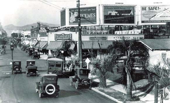
The Evolution of Public Transit in Los Angeles                                                                               Transit

      ince the early 1900's and lasting half a century, there were two major, privately-operated electric railway systems serving
      Southern California. The primary one was the Pacific Electric Railway which was an inter-urban system in mostly dedi-
 cated right-of-way. It covered metropolitan Los Angeles, the San Fernando Valley, the San Gabriel Valley, coastal cities in
 Los Angeles and Orange Counties and most cities in between. Its trains were known as the Red Cars. The other system was
 the Los Angeles Railway Company, an urban street car system covering Downtown Los Angeles and nearby areas such as Ea-
 gle Rock, Highland Park, Vernon, Huntington Park, and Inglewood. Its trains were known as the Yellow Cars.
 As communities grew, there was a gradual decline in ridership coupled with an increase in
 the number of grade crossings. As a result, the effectiveness of these systems were re-
 duced due to the delays and collisions at crossings. The owners were not financially able The Red Cars and Yellow
 to make capital expenditures that might improve and preserve the lines, such as grade Cars served Los Angeles
 separations, improved terminal access and updated equipment. Thus, new lines used mo- for half a century.
 tor buses and some lines started to be converted to motor buses. Although this conver-
 sion was delayed somewhat by World War 2, it accelerated rapidly in the years after the
 War.
 In 1944, the Los Angeles Railway was sold and renamed as Los Angeles Transit Lines and, in 1955, converted most of its trol-
 ley lines to bus operation. Meanwhile, the privately-operated Pacific Electric ceased operation in 1953, and a new private com-
 pany, Metropolitan Coach Lines, acquired its passenger service franchise and motor coach equipment. In the process, many
 service lines were abandoned since they were not profitable. As a result, transit service was much less accessible than it had been
 in the prior decade.
                                       In response, the California Legislature decided that the time had arrived to establish a
                                       public transit agency to serve Los Angeles County. On March 3, 1958, the Metropolitan
                                       Transit Authority (MTA) began operation after the acquisition of the properties of the
                                       Metropolitan Coach Lines and Los Angeles Transit Lines. Other, smaller lines were ac-
 Metro was created                     quired, as well, although a few municipal lines would continue to operate complementary
 in 1993.                              to the MTA system. The consolidation resulted in operating efficiencies.

                                       During this transitional period from private-to-public operation of public transit, it was
                                       expected that fare box revenue would be able to cover all transit related costs.
  For awhile it was feasible to meet all operating expenses of the conventional surface transit system due to the efficiencies of the
  consolidation. However, it was not financially feasible to build a true mass rapid transit system with fare box revenue alone.

  In 1964, Congress passed the Urban Mass Transit Act which provided for capital grants of up to two-thirds for transit capital
  improvements. However, the MTA had no mechanism to provide matching funds. Thus, the Legislature created the Southern
  California Rapid Transit District (SCRTD or RTD) as the successor to the MTA on November 5, 1964. The RTD was au-
  thorized to propose to the electorate a rapid transit program to be financed by general obligation bonds. Several proposals
  were offered only to be turned down by the electorate. Finally, in November 1980 Los Angeles County voters approved
  Proposition A, which increased sales taxes by one-half cent, for the purpose of improving and developing a multi-modal transit
  system. Ground breaking for the construction of the Metro Red Line subway system occurred in September 1986, after federal
  funds were secured to match local funds.

  Meanwhile, the Los Angeles County Transportation Commission, an agency created in 1976 primarily to program local trans-
  portation funds, was planning and constructing the Metro Blue Line. During the latter part of the 1980's, duplication of effort
  and rivalry among the two transit agencies became apparent. In order to resolve this problem, the Legislature created the Los
  Angeles County Metropolitan Transportation Authority (MTA) as the successor to both the SCRTD and LACTC, on April
  1, 1993.
Angels Flight Story Transit
t is one of Los Angeles’ true landmarks, a link to the past and a vintage form of transportation. It is our
last remaining funicular railroad known as Angels Flight.
At the turn of the 19th century, the area southerly of 1st Street and east-
erly of Hill Street was changing from residential to commercial develop-
ment. A new City Hall was being built on Broadway between 2nd Street
and 3rd Street making this area the business center of the City. Just to
the west, there were magnificent Victorian mansions on Bunker Hill,
owned by the socially prominent families of Bradbury, Coulter, Crocker,
Larronde and Widney. However, due to the steep incline, many other
families located elsewhere.
In 1901, the boring of the 3rd Street tunnel was completed which pro-
vided quicker access to the area west of Bunker Hill. However, it didn’t
link up with Bunker Hill itself. It was at this time that Colonel J. W.
Eddy considered the possibility of a funicular to Millionaire’s Row at the
top of Bunker Hill.
James Ward Eddy practiced law in Chicago, became a close friend of
Abraham Lincoln and campaigned for him. When the Civil War
The setting of Angels Flight in erupted, Eddy enlisted in a battalion recruited to protect the nation’s
the 1950's capital. He would later serve in the Illinois state legislature, then as a
construction engineer for the Mineral Belt Railroad in Arizona, and as a
Graphic - 6010
surveyor for the Kern River and Los Angeles Electric Power Company.
At age 69, he ventured again by taking the risk of financing and building
Angels Flight.
The City granted him a franchise to run an electric cable railway along
the 3rd Street right-of-way between Hill Street and Olive Street. How-
ever, fearing that the new railway might be considered a monopoly, the
City required Eddy to construct a free stairway on the north side of the
3rd Street right-of-way. The stairway consisted of 123 steps and ten
ramps and landings. On December 31, 1901, the new railway was offi-
cially opened.
In the manner of fine railway cars, the Angels Flight cars were named
“Olivet” and “Sinai” and were painted a “saintly” white. An archway
greeted passengers at the Hill Street entrance while a canopy covered the
plaza at the Olive Street summit. It was fancifully called Angels Rest and
featured a 100- foot observation tower equipped with a camera obscura.Angels Flight Story, continued Transit
The grand homes on Bunker Hill eventually fell out of fashion, then into disrepair and finally would become
rooming homes. The Community Redevelopment Agency (CRA), created to redevelop Bunker Hill into a
high-rise office center, proceeded to buy and demolish homes as they became vacant. In 1962, they took title
to Angels Flight and by 1966 owned virtually all properties on Bunker Hill.
Due to the regrading of the Hill that occurred with redevel-
opment, it was necessary to close Angels Flight on May 18,
1969. The CRA promised to someday rebuild Angels Flight
and that promise was fulfilled 27 years later on February 24,
1996, one-half block to the south.
It would run five more years, just shy of its centennial, when
a malfunction resulted in the death of a passenger on Febru-
ary 1, 2001. It remained closed for nine years. During the
closure, the braking and mechanical systems were redesigned
to reflect the original design. Finally, on March 15, 2010,
the icon of transportation nostalgia, Angels Flight, resumed The original setting of Angels Flight
operation.
Graphic - 7025
Angels Flight on the Olive Street side
Graphic—7032The Funicular Transit Systems Transit
ithin a short span of 15 years, electric rail lines replaced the cable car lines which replaced the horse car
lines which replaced horse wagons. Thus, the cable cars were perceived as yesterday’s technology. But its
demise was declared prematurely.
The concept of using cables for incline railways became
popular as a means of lifting passengers up very steep
grades. The concept consists of two counter balanced
cars which move up and down on parallel tracks. Much
of the load of each car is balanced by the load of the
second car with the engine handling the unbalanced
load and friction. In the alpine regions of Europe, these
systems became known as funiculars. The song,
“Funiculi, Funicula”, composed by Luigi Denza in
Postcard for Angels Flight
1880, celebrated the funicular up the slopes of Mt. Ve-
suvius. Graphic - 6031
Incline railways were suitable for the hillside areas adjacent to Downtown before the automobile age provided
an alternative mode of access. There would be five vintage funiculars in the Los Angeles area. The first and
most dramatic was the Mt. Lowe Railway, which extended 3,000 feet from Rubio Canyon to Echo Mountain
northeast of Pasadena. It began operation on July 4, 1893 and was abandoned in 1939. It would be the
only one outside of the City.
One existed for a short period in Playa del Rey circa 1904 near Vista del Mar, southerly of Culver Boule-
vard. It was abandoned when a hotel at the top of the hill burned down.
Another funicular was the Los Angeles and Mt. Washington Railway, extending 2,900 feet along Avenue 43
between Marmion Way and Hotel Mt. Washington. It began operation in 1909 and was abandoned in
1919.
A third funicular was the Court Flight Railway along Court Street between Broadway and Hill Street.
(Court Street used to exist along the east-west alignment between the Department of Water and Power John
Ferraro Building and City Hall.) It was constructed in 1904 and was abandoned in 1944.
The fourth and most enduring funicular was Angels Flight. It was aligned along the south side of 3rd Street
and extended westerly from Hill Street. It started operation on December 31, 1901. Service was suspended
on May 18, 1969 and the cars and trucks were retained in storage. On February 24, 1996, it was reopened a
half block to the south, but closed again on February 1, 2000 after a malfunction and passenger death.
There was another operating funicular for the Victoria Station restaurant at Universal Studios in the 1970's.
However, it was more of a tourist attraction than a necessary mode of travel.The Creation of Commuter Rail in Southern California Transit
he railway system in the United States was developed by private entrepreneurs. By 1869, the system reached both coasts
and on September 5, 1876 it reached Los Angeles. Before long, there would be three private rail lines linking Los Ange-
les with other cities - Southern Pacific, Union Pacific and the Atchison, Topeka and Santa Fe (Sante Fe). After many years of
operation, they finally consolidated their three separate passenger terminals. The site of that union was named Union Station,
which opened May 3, 1939.
Trains were the most viable mode of intercity passenger travel until jet travel emerged
in the early 1960's. As passenger travel declined, these rail carriers were left with a
few useful lines for transport of cargo but many more lines no longer were needed for Union Station opened May 3,
passenger travel. As a result, the rail lines started selling off parcels of their land to 1939.
developers of warehouses and a variety of industrial uses. In 1971, the federal govern-
ment, under the name, Amtrak, took over passenger operations on these private rail
lines.
In March 1989, Southern Pacific Railroad indicated its intention to auction its extensive Southern California right-of-way, rather than
sell it one parcel at a time. Shortly thereafter, Santa Fe became involved in discussions regarding the sale of its right-of-way. Just before
these discussions got underway, both Riverside County and San Bernardino County passed sales tax measures for transit improvements
which involved commuter rail. Just after the discussions began, California voters approved three rail bond measures, Propositions 108,
111, and 116 in June 1990.
Very suddenly, a new vision was formed of a new regional commuter rail network, to be
formed from the remnants of the historical national network. Along with that vision
was a sense of urgency and belief that it was indeed achievable within a short time frame.
Metrolink opened October In October 1990, the transportation commissions of Los Angeles, San Bernardino and
26, 1992 with 112 miles, 2.5 Ventura Counties purchased the Southern Pacific right-of-way for $450 million, under
lines and 11 stations. an interim joint powers agency. The next month, voters of Los Angeles County ap-
proved Proposition C while voters of Orange County approved Measure M. By August
1991, the joint power authority would include Riverside and Orange Counties and the
Southern California Regional Rail Authority (SCRRA) was established.
In January 1992, small but critical lines from Union Pacific were purchased, which would allow direct access into Union
Station. In June 1992, Santa Fe finally agreed to sell its extensive right-of-way for $500 million. With this purchase, all of
the vital lines were under public ownership, such that a five-county regional rail transit network was possible. Modern rail
cars were purchased and miles of track were replaced. The five-county system, named Metrolink, opened October 26,
1992, with 112 miles, 2.5 lines and 11 stations. Today, it has 383 miles, 7 lines, and 51 stations, and 34,000 daily riders.
It was an incredible fete to conceive, negotiate, purchase, plan, and build a regional system in just 3-1/2 years. This was due
to several factors. First, there was the opportunity, first announced by Southern Pacific Railroad. Then there was the en-
thusiasm and leadership by Neil Peterson the Executive Director of the Los Angeles County Transportation Commission.
Then, of course, there was the hard work and skillful negotiations with the railroad executives by Richard Stanger, the first
Executive Director of SCRRA, and numerous others. Certainly, there was the political imperative to deliver the system
prior to the 1992 general election. But, most of all, the primary factor was the ability to avoid an extensive environmental
process.
The environmental process was streamlined through a variety of ways. Time-consuming studies were avoided by not using
federal funds. Only state and various county funds were used. Further, the California Environmental Quality Act was
amended a decade earlier to categorically exempt railroad rights-of-way. However, since stations were outside of railroad
rights-of-way, this presented a dilemma. In order not to complicate the Metrolink construction efforts, cities were requested
to seek environmental clearances, design and build stations where they wanted access to the system. This arrangement con-
tinues to this day and allows cities to co-invest in the success of Metrolink.Standard Railroad Gauge Transit
came across an article a few years ago which explained the dimensions used in both the world’s most effi-
cient transportation system and most advanced transportation vehicles. I’m referring to the United
States standard railroad gauge of 4 feet 8 ½ inches between rails (center to center). The answer is not what
you might expect!
The standard gauge is an odd number. Why not 4 feet or 5 feet even?
The first explanation is that British expatriates built the first U.S. rail- Did you know the standard railroad
roads just as they did in England where railroad travel originated. A gauge is based on the dimensions of
further explanation is that the first rail lines in England were built by Roman chariots?
the same people who built the pre-railroad tramways and used the
same gauge.
But why did they use that odd gauge for the tramways? It is because the people who built the first tramways
used the same jigs and tools used for building wagons.
So why did wagons have that odd wheel spacing? The answer is that they tried to match the wheel ruts on
some of the old long distance roads in England, as any other spacing would tend to break the wagon wheels.
Okay, but who built those old rutted roads? The first long distance roads were built by Ancient Rome and
the initial ruts were created by the Roman war chariots. Since all of the chariots were made by Ancient
Rome, they were of a uniform width. Since then, all subsequent wagon wheels used the same width so that
their wagons would not be damaged.
Thus, the standard railroad gauge, used for most freight rail and transit rail systems, is based on axle dimen-
sions of the Imperial Rome war chariots.
In fact, the large booster rockets attached to the sides of the main fuel tanks of space shuttles are based on
the standard railroad gauge. That’s because the booster rockets are manufactured in Utah and shipped to the
launch site. The railroad line from the factory passes through a tunnel in the mountains just slightly wider
than the track itself. Thus, the width dimension of the world’s most advance transportation vehicle also is
based on the size of the Roman war chariot.
But what governed the size of the Roman was chariots? Well, if you can recall the scenes of old Kirk Doug-
las and Charlton Heston movies, the chariots were pulled by two horses. Thus, the chariots were made just
wide enough to accommodate the aggregate width of two war horses.
So, in summary, the major design dimension for both the most efficient surface transportation system and
the most advance transportation vehicle is based on, well, a horse’s rear.Jitneys, A Recurring Idea Transit
here is an idea that is suggested every few years and then discarded until the next time. It’s the concept
of jitney service and it was invented here in Los Angeles.
In 1915, Mr. L. P. Draper was driving his Model T Ford
along Wilshire Boulevard. He saw a group of people
waiting for a trolley car and decided to transport anyone
who would ride with him for a “jitney”, the slang term
at that time for a 5 cent piece. The idea quickly caught
on and within weeks hundreds of jitneys were operating
along the Yellow Car lines. Within months, the idea
spread throughout the nation and eventually the world.
Streetcar operators who had invested significant capital
to build and operate rail lines were outraged. They
claimed that the jitney operators were “skimming the Advertisement for taxicab service in Los Angeles
cream”. Because jitneys threatened the viability of the from the 1920's
privately operated public transit operators, they were
Graphic - 2064
outlawed in most American cities.
Today, publicly-operated transit systems serve a variety routes, virtually none of which recover full costs. In
addition, taxicab companies are franchised and drivers are permitted to serve a variety of short, long and re-
mote trips. Jitneys, on the other hand, would travel only the most popular routes, use the established transit
stops and invite passengers to travel in uninspected automobiles by persons with unknown backgrounds. For
these reasons, and in support of the authorized transit and taxicab systems, jitneys continue to be outlawed.The City’s First Road Roadways
oday, the City has 160 miles of freeway and 6,500 miles of street, which includes nearly 1,500 miles of
multi-lane thoroughfares. These are the vital arteries that serve the nation’s second largest City.
While you might think that the City’s road system had
very humble beginnings, it maybe be surprising to learn
that it was commissioned by royalty, specifically, the
King of Spain. The City’s first road would link the pre-
sidios, missions and pueblos of California.
Spanish control of Alta California began in 1769 when
Gaspar de Pórtola was ordered by the King Carlos III to
explore and occupy new territory and establish presidios
for protection. These presidios would represent Spain’s
claim to Alta California if challenged by England or
Russia. By 1782, four presidios were established in San El Camino Real linking the California missions
Diego, Santa Barbara, Monterey and San Francisco.
Graphic - 2040
Traveling with Pórtola was Junípero Serra who established the first mission. He would establish nine mis-
sions and by 1823 there would be 21 missions in all. Father Serra lived an austere life and was personally
committed to the mission of saving souls versus the “civilizing” Native Americans as subjects of the King
of Spain for which the missions would become known. Eventually, each mission was about 30 miles apart
or a one-day’s journey.
In 1777, Felipe de Neve recommended the formation of two agricultural settlements to support the presi-
dios. The settlements were to be known as pueblos. By order of King Carlos III, the first was established in
San Jose in 1777. The second was established on the banks of the Porciuncula (Los Angeles River) when 44
settlers from Baja California arrived in groups from the nearby San Gabriel Mission. On September 4, 1781
planting fields and house lots were distributed to the settlers officially beginning the new El Pueblo de la
Reyna de los Angeles.
The dirt road connecting the presidios, missions and pueblos would become known as El Camino Real,
which literally translates to The Royal Road, or more popularly known as The King’s Highway. Today, the
exact path they followed is uncertain. However, their diaries suggest that they overlooked the Arroyo Seco in
present day South Pasadena, crossed the Porciuncula (Los Angeles River) near today’s North Broadway
Bridge, noted the tar near today’s La Brea Tar Pits near Wilshire Boulevard, hiked through Sepulveda Pass and
walked near present-day Ventura Boulevard. Over time, the original El Camino Real would be replaced by
new paths, dirt roads, a network of paved streets and modern freeways. The route that most closely approxi-
mates historic El Camino Real is Interstate 5 between San Diego and Los Angeles and US 101 between Los
Angeles and San Francisco.
The sites of the 21 missions, four presidios and two pueblos have become the major coastal cities of Cali-
fornia and Los Angeles and San Francisco are world renowned. They can all trace their origins to California’s
first, best known, and most regal of highways, El Camino Real.The El Camino Real Bells Roadways
alifornia’s first and most historic route is identified in a very special way. El Camino Real is the corridor that connected
21 missions, four presidios and two pueblos between San Diego and San Francisco during California’s Spanish colonial
period. Today, the corridor is marked with distinctive bells.
As cities along the corridor began to develop in the late 19th Century, there was a desire to preserve
this important link to California’s early years. The notion of preserving El Camino Real was first
proposed by Anna Pitcher of the Women’s Club of Los Angeles in 1892. Eventually, the idea would
move forward under the guidance of Mrs. Armitage Forbes. She and her husband formed the El
Camino Real Association in 1904 to investigate the original route and to provide distinctive mark-
ers. The marker selected was a miniature mission bell modeled after the bells of the Old Plaza
Church in Los Angeles. The cast iron bells were hung from eleven-foot pipes bent at the top in the
shape of a question mark. In August 1906, the first one was installed in front of the Old Plaza
Church. In all, the El Camino Real Association installed 158 bells along the route by 1915.
In time, the bells fell into disrepair and some had been stolen. From 1926 to 1931, the California
State Automobile Association and the Automobile Club of Southern California assumed responsibil-
ity for maintenance and replacement of bells on the early State highways, just as they did for route
shields. However, over the years theft and vandalism took its toll. Finally, in 1974 the Legislature
appointed Caltrans as guardian of the bells on the current State Highway System, with the California El Camino Real link-
Federation of Women’s Clubs taking the lead on bells on the conventional, older roads not on the ing the California
current State Highway system. missions
Graphic - 2040
In 2000, Caltrans received a federal grant to restore the El Camino Real Mission bell marker system from Orange County to
San Benito County. The bells were cast exactly like the original ones. A total of 555 bells were installed at one-to-two mile
intervals along the historic route for the centennial celebration in August 2006.
The first bell in August 1906
Graphic - 8123
El Camino Real bell along US 101
Graphic - 2041The Roots of Our Routes Roadways
ithout directional and route signs this mobile society could not exist. Today’s main traveled highways and freeways are
well-signed and known primarily by their route numbers. It is easy to travel across the country just by following them.
However, this was not always the case. Highways have been variously identified by their historical significance, administrative
numbers and several evolutions of rational numbering systems. Private citizens, automobile clubs and state highway depart-
ments have handled the sign posting functions through the years. Here is how it evolved.
Posting of route signs started as a one-time historical identification effort. Beginning in ³
1906, a private group began erecting distinctive mission bells on metal poles along El
Camino Real. A few years later, the need to identify other routes arose as the automobile
started to gain popularity. The State of California started to identify California routes
Before there were high-
after approval of initial bond funding for the birth of the State Highway System in No- way route numbers,
vember 1910. Although these initial state routes were given administrative identification there were thematic
numbers they were not posted for motorists. As a result, the Automobile Club of South- names for roads.
ern California (ACSC) and the California State Automobile Association (CSAA) volun-
teered to sign these routes. Outside of California, motoring clubs headquartered on the ´
East Coast did likewise.
The interstate guidance signs posted by the automobile clubs identified not
only the distances and directions to cities, but also named the routes being
traveled. Unlike the functional names of routes that we travel today the
original cross-country routes had thematic and often romantic designations
which reflected the sense of adventure that early motorists would experience.
The names included Old Spanish Trail, Midland Trail, Pacific Highway,
Lincoln Highway, California Banff Bee Line, New Santa Fe Trail, National
Old Trails Road, and Pike’s Peak O’ to O’ (Ocean to Ocean) Highway.
The first posting of these thematic routes was the National Old Trails Road
which was undertaken by ACSC in 1914. The others were completed be-
tween 1915 and 1922. Some of the signs are posted in the ACSC courtyard
at 2601 S. Figueroa Street, Los Angeles.
By the mid 1920's the federal government realized that the signing of a de-
veloping national network of highways needed to be simplified and uni-
form. As beautiful as the thematic highways names were, the continued
naming of new routes for an expanding system would be cumbersome. Ac-
cordingly, the federal government in cooperation with the American Asso-
ciation of State Highway Officials (AASHO) established US (United
States) numbered routes which were formally adopted in 1926. Almost
without exception, the thematic routes were incorporated into the US sys-
tem. AASHO created a rational system of numbered routes where odd
numbers represented generally north-south routes, and even numbers repre-
sented for east-west routes. Numbers increased from east to west and from
north to south. Thus, US 1, is along the East Coast, while US 101 was
designated along the West Coast. A distinctive black-on-white US shield
was created. In California, the signs began to be posted by ACSC and
CSAA in 1927 but in other areas of the country the state highway depart-
ments undertook the responsibility. In 1934, ACSC and CSAA began
posting California State Highway signs shaped like a gold miner’s shovel.
Graphic 2043 They continued this function until 1947.The Roots of Our Routes, continued Roadways
In 1927, there were only four US routes connecting Los
Angeles with the rest of the nation. From the south,
was US 101 from San Diego along Whittier Boulevard,
Boyle Avenue, and 7th Street; from the north was US
99 along San Fernando Road; from the northwest was
US 101 along 7th Street, Vermont Avenue, Sunset
Boulevard, Cahuenga Boulevard and Ventura Boulevard;
and from the east was US 66 and US 99 along Colo-
rado Boulevard, Fair Oaks Avenue, Huntington Drive,
Mission Road and Broadway. By the mid 1930's other
US routes were added.
³
The Automobile Club of
Southern California and
the California State Auto-
mobile Association posted
the first route number
shields in 1927.
´
The US and California route numbering systems lasted
for many years. However, in 1956 the Interstate High-
way System of nationally significant freeways was con-
ceived and a new route shield was developed. Many of
the new Interstate routes were superimposed over for-
mer US routes, such as the Santa Ana Freeway, formerly
US 101, becoming Interstate 5. In order to minimize
the confusion of having three routes numbering systems,
most of the routes in California were renumbered in
1964. By 1969, the Interstate and California numbered
routes would replace most of the US numbered routes
in California. Today, US 101, the Hollywood and
Ventura Freeways, is the only survivor of the initial Graphic—3025
numbered highway system in Los Angeles.The Main Street of America Roadways
merica’s Main Street was the backdrop of a major epic, lyricized in a hit song, romanticized in a weekly
television series, rhythmicized in an instrumental, and included in the title of a major service station
chain. The California Legislature designed it as the first special highway of its kind. The highway passes
through the heart of Southern California.
The story of US 66, or as it is more affectionately know, “Route
66", is also the story of our early highway system. The original
route, extending from Chicago to Los Angeles, was officially desig-
nated on November 11, 1926 but has disappeared from our maps
as a victim of progress, relinquishment and route simplification.
Before it was US 66, it was part of the National Old Trails Road.
Its links of highway would later be relinquished and reorganized in
favor of Interstate Freeways 15, 40 and 210, the Pasadena Freeway,
a portion of the Hollywood Freeway and Santa Monica Boulevard.
Only a relatively short reach of Foothill Boulevard near the Los An-
geles County/San Bernardino County line retains the number with
the designation, California 66. Although it has virtually disap- LADOT installs unique Route 66 Signs on
peared from maps, its memory lives on with continued commemo- Santa Monica Blvd.
Graphic - 7011
ration.
Route 66 was first acknowledged in the 1940 movie classic, “The Grapes of Wrath” starring Henry Fonda.
It showed “Okies” during the Great Depression trying to escape the Dust Bowl devastation of their farm-
lands by heading west. As they made progress in reaching each new state the film showed the US 66 shield
with the name of that state on top.
In the late 1940's, Nat “King” Cole recorded the Bobby Troup-penned song with the catchy lyric, “Get Your
Kicks on Route 66". The song described traveling through each major city between Chicago and Los Ange-
les.
In the early 1960's there was a weekly television series called “Route 66". Staring George Maharis and Mar-
tin Milner (later of “Adam 12" fame), it used the highway as the background setting for a variety of adven-
tures as they traveled from town to town. The theme music for the television series was a smash hit by Nel-
son Riddle. It was a highly-produced, fully orchestrated instrumental and one of the finest highway cruising
tunes ever recorded.
At the terminus of Santa Monica Boulevard at Ocean Avenue the City of Santa Monica has a plaque which
dedicated Route 66 as Will Rogers Highway. The naming reflected an affection not only for the 20th cen-
tury humorist from Oklahoma, but also for a route which literally and figuratively transported a person of
humble origins into the hearts of Americans.
A chain of service stations in the late 1960's hoped to capitalize on the mystique of Route 66 with their
Phillips 66 stations. Their logo displayed the US route shield. Apparently, the management was unaware of
route simplification enacted in 1964 which would result in a renumbering of routes throughout the United
States. By the 1970's Phillips 66 disappeared faster than the route itself.The Main Street of America, continued Roadways
here were several routes through Southern California reflecting the improvement in roadways. The origi-
nal 1926 route followed Colorado Boulevard, Fair Oaks Avenue, Huntington Drive, Mission Road and
North Broadway to 7th Street (US 101). Around 1935, the route was extended westerly along Sunset Boule-
vard, Manzanita Street, Santa Monica Boulevard, and Lincoln Boulevard to Olympic Boulevard (junction of
US 101 Alternate). Between 1935 and 1939 the routing between Pasadena and Downtown Los Angeles had
several interim changes during the construction of the extension of Figueroa Street and its tunnels (now the
northbound lanes of the Pasadena Freeway). By 1941 the routing was along Colorado Boulevard, Arroyo
Parkway, and the Arroyo Seco Parkway. Ten years later the new Hollywood Freeway replaced Sunset Boule-
vard as a link of the route.
You may feel a sense of nostalgia in driving portions of the original route.
Imagine the country before freeways at a time when reaching the West Coast The original terminus of US 66
was a manifest destiny. After traveling through Illinois, Missouri, Kansas, was at the intersection of 7th
Oklahoma, the desert areas of Texas, New Mexico, Arizona and California Street and Broadway. Later,
and passing through the Cajon Pass you enter Southern California. As you the terminus would be at the
intersection of Lincoln Boule-
drive along the Foothill communities you start to develop a sense of passing vard and Olympic Boulevard..
through a special gateway. Appreciate the landscaped median of Huntington
Drive. Observe the architecturally preserved business districts of Pasadena,
South Pasadena and Lincoln Heights. Look in awe at the beautiful arch
bridge of Colorado Boulevard over the Arroyo Seco. Enjoy the scenic drive
through Highland Park. Note the art deco style portals and stone-and-
mortar walls of the northbound lanes of the Arroyo Seco Parkway through
Huntington Drive, Fi-
Elysian Hills and imagine it as a two-way Figueroa Street. Observe the
gueroa Street, Broad- magnificence of the towers in Downtown Los Angeles and continue fur-
way and the Arroyo ther west. View the linear park and fountains in Beverly Hills and continue
Seco Parkway were part until you reach and end of old US 66 at the intersection of Lincoln Boule-
of Route 66 at various vard and Olympic Boulevard. As you arrive at this point at the foot of
points in time. beautiful Santa Monica Bay you can’t help but have a feeling that you’ve
reached your ultimate destination. Undoubtedly, you realize you’re not in
Kansas anymore.Figueroa Street, A Preview of the Future Roadways
lthough we may recognize it as just another arterial street, Figueroa Street was once the longest street in the
City, the site of the first interchange and the beginning of the freeway system.
Prior to the dawn of the 20th Century, it was known as Grasshopper Street
and marked the western edge of Downtown. Its northerly terminus was a
residential street ending in the Elysian Hills and now known as Figueroa Ter-
race.
The 1924 milestone report, Major Traffic Street Plan, identified the need for
a bypass roadway to relieve busy Broadway. Broadway was the only direct
route into Downtown Los Angeles from the north and received national rec-
ognition in 1926 when it was identified as the final link of US 66. However,
Broadway was severely overcrowded and its intersection at 7th Street was the
busiest in the world. As a result of the severe congestion on Broadway, plan-
Construction of the Fi- ning got underway to build a new road parallel to Broadway through the Ely-
gueroa Street tunnels sian Hills and across the Los Angeles River. Due to the immensity of the
project it proceeded in many stages.
Graphic - 4075
Tunnels
The first stage was to extend Riverside Drive to the south and extend it over
the Los Angeles River, ending at San Fernando Road. This was completed in
1929. Then, three tunnels were mined through the Elysian Hills between So-
lano Avenue and the edge of Los Angeles River in 1931. From the end of
the most northerly tunnel, the new roadway was extended to join the River-
side Drive bridge over the Los Angeles River. We know this extension today
as the transition road from the northbound Arroyo Seco Parkway to the
An early (1925) concept of grade-
separated roadways
northbound Golden State Freeway. At this point, one could access Figueroa
Street from Broadway and Solano Avenue, turn right travel through the three
Graphic - 3075 tunnels curve to the left then turn sharply right onto the Riverside Drive
bridge over the Los Angeles River. In 1935, the fourth tunnel was built.
Directly Across the Los Angeles River
In recognition of its emerging importance, the new roadway was incorporated
into the State Highway system. Dayton Avenue (northerly of San Fernando
Road), Pasadena Avenue (northerly of Avenue 39) and Annandale Boulevard
(northerly of York Boulevard) were renamed Figueroa Street. Northerly of
Downtown, the consolidated and renamed segments of Figueroa Street would
replace Broadway, Mission Road, Huntington Drive and Fair Oaks Avenue as
The original three Figueroa
the new official alignment of US 66. In 1937, Figueroa Street was extended
Street tunnels in 1931.
Graphic - 8055 from the most northerly tunnel, directly over the Los Angeles River connect-
ing with renamed Figueroa Street opposite Avenue 22 in a sweeping 90-
degree curve. State funds were used for this project.Figueroa Street, A Preview of the Future, continued Roadways
nto the Civic Center
Finally, in 1939 the bypass roadway of Figueroa Street would reach Downtown Los Angeles. The roadway was ex-
tended southerly from Solano Avenue to a point north of Alpine Street to join the older extant segment of Figueroa
Street. The extension included a grade separation at College Street. This last segment was funded in part, from the
federal Public Works Administration Program. With completion of the extension to Downtown it became the longest
street in the City, extending from B Street in the Wilmington community to Colorado Boulevard in the Eagle Rock
community, 31 miles in all, with 24 miles within the City. The segment northerly of Sunset Boulevard became the new
alignment of US 66, while the segment southerly of Sunset Boulevard would become part of US 6.
As part of the extension into the Civic Center, a grade separation was constructed at Tem-
ple Street. It was noteworthy for being the first diamond interchange to be built in
Southern California and perhaps in the Western United States. At the time it was con-
structed, it connected with the terminus of Flower Street. In the early 1960's, Flower
Street was truncated northerly of 3rd Street due to Bunker Hill redevelopment and the
construction of the headquarters for the Department of Water and Power.
The Figueroa Street bypass road is a fine example of function with artful design. A close
examination of the College Street and Temple Street bridges shows simple but attractive
designs with distinctive relief features. The walls of the Temple Street grade separation
and the rounded lines of the Los Angeles River bridge abutments hint of the Streamline
Moderne era. In contrast, the portals of the four tunnels proudly show the City seal in art
deco scalloping and remind us of the Jazz Age and the City’s aspirations.
From conception to completion, the Figueroa Street bypass road was a 15-year effort.
But while the tunnels, grade separations and diamond interchange seemed like the conclu-
Completion of the Figue- sion to the City’s greatest public works project to date, they merely anticipated the begin-
roa Street bridge over the ning of a new system of roadways. From Figueroa Street evolved Arroyo Seco Parkway,
Los Angeles River, 1937. the Cahuenga Boulevard Parkway and the freeway system. Much of the original alignment
of the expressway portion of Figueroa Street, from College Street to Avenue 22, remains
Graphic - 1020
intact today.
Construction of the Figueroa Street Construction of the Figueroa Street
grade separa tion and di amond i nter- bridge over the Los Angeles River.
change at Temple Street.
Graphic - 8046 Graphic - 8040You can also read