ARTICLE - The People of Earth & Planetary Sciences
←
→
Page content transcription
If your browser does not render page correctly, please read the page content below
Pagination not final (cite DOI) / Pagination provisoire (citer le DOI)
1
ARTICLE
Late Neoproterozoic – early Paleozoic basin evolution in
the Coal Creek inlier of Yukon, Canada: implications for
the tectonic evolution of northwestern Laurentia
James F. Busch, Alan D. Rooney, Edward E. Meyer, Caleb F. Town, David P. Moynihan,
and Justin V. Strauss
Can. J. Earth Sci. Downloaded from cdnsciencepub.com by 98.216.152.57 on 03/09/21
Abstract: The age and nature of the Neoproterozoic – early Paleozoic rift–drift transition has been interpreted differently
along the length of the North American Cordillera. The Ediacaran “upper” group (herein elevated to the Rackla Group) of
the Coal Creek inlier, Yukon, Canada, represents a key succession to reconstruct the sedimentation history of northwest-
ern Laurentia across the Precambrian–Cambrian boundary and elucidate the timing of active tectonism during the pro-
tracted breakup of the supercontinent Rodinia. These previously undifferentiated late Neoproterozoic – early Paleozoic
map units in the Coal Creek inlier are herein formally defined as the Lone, Cliff Creek, Mount Ina, Last Chance, Shade, and
Shell Creek formations. New sedimentological and stratigraphic data from these units is used to reconstruct the depositio-
nal setting. In the Last Chance Formation, chemostratigraphic observations indicate a ca. 5% d13Ccarb gradient coincident
with the globally recognized ca. 574–567 Ma Shuram carbon isotope excursion. Map and stratigraphic relationships in the
overlying Shell Creek Formation provide evidence for latest Ediacaran – middle Cambrian tilting and rift-related sedimen-
tation. This provides evidence for active extension through the Cambrian Miaolingian Series in northwestern Canada, sup-
porting arguments for a multiphase and protracted breakup of Rodinia.
For personal use only.
Key words: Rodinia, Yukon, Shuram carbon isotope excursion, Rackla Group, Coal Creek inlier.
Résumé : Les interprétations diffèrent quant à l’âge et la nature de la transition de rifting à dérive, du Néoprotérozoïque
au Paléozoïque précoce, le long de la cordillère nord-américaine. Le groupe d’Ediacara « supérieur » (élevé dans le présent
article au Groupe de Rackla) de l’enclave de Coal Creek (Yukon, Canada) représente une succession clé pour reconstituer
l’histoire sédimentaire du nord-ouest de la Laurentie de part et d’autre de la limite Précambrien–Cambrien et élucider la
chronologie de l’activité tectonique durant la longue dislocation du supercontinent Rodinia. Ces unités cartographiques
d’âge néoprotérozoïque tardif à paléozoïque précoce dans l’enclave de Coal Creek, qui n’étaient pas différenciées aupara-
vant, sont formellement définies comme étant les Formations de Lone, de Cliff Creek, de Mount Ina, de Last Chance, de
Shade et de Shell Creek. De nouvelles données sédimentologiques et stratigraphiques sur ces unités sont utilisées pour
reconstituer le contexte sédimentaire. Dans la Formation de Last Chance, des observations chimiostratigraphiques indi-
quent un gradient du d13Ccarb d’environ 5 % coïncidant avec l’excursion des isotopes de carbone de Shuram vers 574–
567 Ma, reconnue à l’échelle planétaire. Les relations cartographiques et stratigraphiques dans la Formation de Shell Creek
sus-jacente fournissent des preuves d’un basculement et d’une sédimentation reliée au rifting de la fin de l’Ediacara au
Cambrien moyen. Cela indiquerait une extension active pendant la série miaolingienne du Cambrien dans le nord-ouest
du Canada, ce qui argue en faveur d’une dislocation de Rodinia en plusieurs phases et de longue durée. [Traduit par la
Rédaction]
Mots-clés : Rodinia, Yukon, excursion des isotopes de carbone de Shuram, Groupe de Rackla, enclave de Coal Creek.
Introduction et al. 2014; Strauss et al. 2015; Beranek 2017; Campbell et al.
2019; Moynihan et al. 2019). Previous work suggested this tran-
Neoproterozoic and lower Paleozoic strata of the western sition was recorded in strata from the Cryogenian–Ediacaran
United States and Canada generally record a transition from con- Windermere Supergroup of northwestern Canada (e.g., Ross
tinental rifting to passive margin sedimentation during the 1991; Narbonne and Aitken 1995; Ross et al. 1995), with evidence
breakup of the supercontinent Rodinia (e.g., Stewart 1972; Levy for multiphase rifting (Ross 1991; Colpron et al. 2002) and
and Christie-Blick 1991; Lund 2008); however, views differ on the oblique extension (Eisbacher 1981; Strauss et al. 2015) prior to
timing and number of rift episodes (e.g., Fritz et al. 1991; Ross continental separation. In addition, more recent studies have
1991; Dalrymple and Narbonne 1996; Colpron et al. 2002; Post drawn attention to evidence for intermittent extension, syn-
and Long 2008; Turner et al. 2011; Macdonald et al. 2012; Yonkee tectonic sedimentation, and associated volcanism during the
Received 6 July 2020. Accepted 14 October 2020.
J.F. Busch, E.E. Meyer, C.F. Town, and J.V. Strauss. Department of Earth Sciences, Dartmouth College, Hanover, NH 03755, USA.
A.D. Rooney. Department of Earth and Planetary Sciences, Yale University, New Haven, CT 06511, USA.
D.P. Moynihan. Yukon Geological Survey, P.O. Box 2703, Whitehorse, YT Y1A 2C6, Canada.
Corresponding author: James F. Busch (email: james.f.busch.gr@dartmouth.edu).
Copyright remains with the author(s) or their institution(s). Permission for reuse (free in most cases) can be obtained from copyright.com.
Can. J. Earth Sci. 00: 1–23 (0000) dx.doi.org/10.1139/cjes-2020-0132 Published at www.nrcresearchpress.com/cjes on 5 March 2021.
Pagination not final (cite DOI) / Pagination provisoire (citer le DOI)
2 Can. J. Earth Sci. Vol. 00, 0000
Fig. 1. Simplified geological map of Proterozoic–Paleozoic strata in northwestern Canada with major structural and paleogeographic
elements labeled accordingly. The study location is outlined with a red box. Map created using ESRI ArcGIS version 10.7.1 and assembled
from Colpron et al. (2016). [Color online.]
140°0'W 135°0'W 130°0'W
¹¹
Cambrian-Devonian
Alaska Greenland
66°0'N Platformal carbonates
YUKON Arctic Circle
66°0'N
Transitional platform
YUKON Basinal carbonates
ALASKA Canada
Yukon block
Yukon Block United States Basinal clastics
Fig. 2
Proterozoic-Terreneuvian
Daw
son Laurentia
Laurentia Windermere Supergroup
Ri
64°30'N thru Hart River
Can. J. Earth Sci. Downloaded from cdnsciencepub.com by 98.216.152.57 on 03/09/21
st
ch
inlier Goz A
Coal Creek
ar
Wernecke 64°30'N Rackla Group
ds
inlier
Inlier inlier
on
Shale Lake Hay Creek Group
fa
ul
ta
To
mb Hyland Group
rra
sto
Ti Selwyn basin R NWT
y
n tin ne
a thr obe thr undivided
fa us rt S us
ul t t
t erv Proterozoic
ice Sekwi Brook
63°0'N Mackenzie Mtns Supergroup
63°0'N (Tonian)
key locations
Pinguicula Group
major fault (Meso-Neoproterozoic)
Wernecke Supergroup
150 (Paleoproterozoic)
For personal use only.
km
140°0'W 135°0'W 130°0'W
early Paleozoic, with continental margin re-establishment well Geologic setting of the Coal Creek inlier
after deposition of the Windermere Supergroup during the The Coal Creek inlier is the westernmost of three domal Cordil-
middle to late Cambrian (e.g., Beranek 2017; Link et al. 2017; leran structural culminations that are located along the south-
Campbell et al. 2019; Moynihan et al. 2019). ern boundary of the Yukon block (Fig. 1). The Yukon block is a
The Coal Creek inlier of the Ogilvie Mountains, Yukon, Canada, triangular-shaped region in northern Yukon that formed a rela-
is positioned along the southwestern edge of the Yukon Stable tively high-standing block (Ogilvie platform) throughout much
Block (herein referred to as “Yukon block”), a paleogeographic of the early Paleozoic (Jeletzky 1962; Morrow 1999). Extensive
high that accommodated early Paleozoic platformal carbonate deposition of platformal carbonate in this region contrasts with
deposition along the northwestern edge of the Laurentian craton deeper marine siliciclastic-dominated sedimentation in the
(Fig. 1; Jeletzky 1962; Abbott 1997; Morrow 1999). Previous studies Selwyn basin to the south (Gordey and Anderson 1993; Cecile
have correlated Neoproterozoic strata of the Coal Creek inlier 2000). The Yukon block is surrounded on three sides by Mesozoic–
with other regions in the northern Canadian Cordillera, where Cenozoic fold-thrust/strike-slip deformation zones, whereas its
exceptionally preserved strata have been recognized as key loca- interior region is largely unaffected by Cordilleran deformation
tions for studying this interval of Earth history (Macdonald et al. (Fig. 1; Colpron et al. 2016). It is distinguished geophysically by (1) a
2012, 2013, 2018; Strauss et al. 2015); however, upper Neoprotero- high velocity region interpreted as a cold thermal anomaly within
zoic and lower Paleozoic units in the Coal Creek inlier have the upper mantle (Estève et al. 2020); (2) a regional magnetic
remained undifferentiated. To further investigate the evolution anomaly produced by mafic lower crust (Pilkington and Saltus
of the northwestern Laurentian margin, in particular the appa- 2009); and (3) a long wavelength, high Bouguer gravity anomaly
rent multiphase rift history associated with the breakup of (Estève et al. 2020). The lithosphere of the Yukon block is approx-
Rodinia, the previously undifferentiated Cryogenian–Ediacaran imately 100–200 km thick, which is 2–4 times the current thickness
units of the Hay Creek and “upper” groups of the Coal Creek of the lithosphere in the Selwyn basin region (Gaudreau et al.
inlier (Macdonald et al. 2013, 2018) were re-examined. These had 2019). Collectively, the geological and geophysical evidence sup-
previously been referred to informally as the upper Mount Harper port interpretation of the Yukon block as a buried cratonic prom-
Group by Mustard (1988) and Mustard and Roots (1997). In this ontory that is composed of cold, thick, and mechanically robust
paper, the “upper” group is incorporated into the recently for- lithosphere (Abbott 1997; Nelson et al. 2013; Schaeffer and Lebedev
malized Rackla Group of Moynihan et al. (2019). The previously 2014; Estève et al. 2020).
informal Neoproterozoic–Cambrian map units are herein for- The southern boundary of the Yukon block is generally marked
mally defined as the Lone, Cliff Creek, Mount Ina, Last Chance, by the trace of the Dawson thrust, a Mesozoic north-vergent fault
Shade, and Shell Creek formations (Fig. 2, Tables 1–6). From a that accounts for limited structural overlap (Fig. 1; Abbott 1997).
compiled data set of sedimentological observations, strati- The Dawson thrust approximately coincides with the position of
graphic sections, and geochemical measurements, these strata an antecedent, basin-bounding structure that controlled the mar-
provide evidence for protracted latest Ediacaran – early Cam- gin of the Selwyn basin, a large southwest-facing embayment that
brian rift-related tilting and middle Cambrian syn-rift sedimenta- served as a depocenter from the Neoproterozoic – late Paleozoic
tion along the western margin of Laurentia. (Gordey and Anderson 1993; Abbott 1997). The boundary between
Published by NRC Research Press
Pagination not final (cite DOI) / Pagination provisoire (citer le DOI)
Busch et al. 3
Fig. 2. Generalized stratigraphic column of Cryogenian–Cambrian PH3, PH4, and PH5, of the upper Mount Harper Group or the un-
strata in the Coal Creek inlier of west-central Yukon (1Macdonald differentiated Hay Creek and “upper” groups (Mustard et al.
et al. 2018, 2Macdonald et al. 2010, 3Rooney et al. 2020, 4Rooney 1988; Thompson et al. 1994; Mustard and Roots 1997; Macdonald
et al. 2015, 5Condon et al. 2005). [Color online.] et al. 2010, 2011, 2013; Strauss et al. 2014). These Ediacaran map
units are unconformably overlain by unnamed Cambrian silici-
Bouvette clastic rocks (formerly map unit PH5), which are in turn discon-
Cambrian
Formation formably succeeded by carbonate strata of the Bouvette Formation
Rusophycus, Cruziana, (Strauss et al. 2014). The Bouvette Formation in the Coal Creek
Shell Creek Diplocraterion
Formation inlier marks the beginning of widespread platformal carbonate
< 529 Ma (Stage 2)
Shade Fm
sedimentation that comprises the Cambrian–Devonian Ogilvie
Fireweed Mb 567.3 ± 3.0 Ma³ platform (Morrow 1999).
Last Chance Stretching associated with formation of the western Laurentian
Formation continental margin led to widespread subsidence of the attenu-
ated Selwyn basin region, but evidently did not affect lithosphere
Rackla Group
Gladman Mb
of the Yukon block (Cecile et al. 1997; Morrow 1999). Ediacaran and
Ediacaran
Can. J. Earth Sci. Downloaded from cdnsciencepub.com by 98.216.152.57 on 03/09/21
Cambrian units near the southern boundary of the Yukon block
Mount exhibit facies and thickness trends that generally indicate south-
Ina ward deepening from the Yukon block into the Selwyn basin
Formation region (e.g., Gordey and Anderson 1993; Moynihan et al. 2019), but it
is not clear how or when the profound boundary that separates
these regions was first established. The Coal Creek inlier sits
632.3 ± 5.9 Ma⁴
H.C. Cliff Creek Fm 635.2 ± 0.6 Ma⁵
directly adjacent to the Yukon block – Selwyn basin interface
Gp Lone Fm and is therefore a key location to evaluate the significance of
Cryogenian
Rapitan Eagle Creek this boundary and how it relates to the history of Neoproterozoic–
Group Formation 716.9 ± 0.4 Ma² Paleozoic rifting in northwestern Laurentia.
Mount 717.4 ± 0.1 Ma¹
Harper
Group
Mount
Harper 717.7 ± 0.3 Ma²
volcanic 718.1 ± 0.3 Ma² Methods
rocks Geological mapping, measurement of stratigraphic sections,
For personal use only.
and geochemical sampling were undertaken in the Coal Creek
dolostone siltstone inlier in 2017 and 2018. Two remote camps were situated within a
limestone shale/mudstone well-exposed and laterally extensive panel of upper Ediacaran
volcanic/ U-Pb igneous date and lower Paleozoic strata northwest of Mount Harper (Fig. 3).
volcaniclastic This region marks the type region of the new units proposed
Re-Os date
conglomerate/ clastic herein (Tables 1–6). The camps were accessed via helicopter from
diamictite carbonate correlated radiometric
age constraint Dawson City.
sandstone complex trace fossil
d13Ccarb and d18Ocarb chemostratigraphy
Carbonate rock samples were analyzed in the Stable Isotope
Geochemistry Laboratory at Dartmouth College. Limestone and
the Yukon block and Selwyn basin is broadly collinear with a belt
dolostone samples (ca. 0.1–0.5 kg) were collected approximately
of middle Cambrian alkaline mafic volcanic rocks (Goodfellow
every metre throughout measured stratigraphic sections and tar-
et al. 1995; Cecile 2000; MacNaughton et al. 2016; Mamrol et al.
geted to avoid obvious fracturing or veining. The samples were
2016) and ultramafic rocks of unknown age (Colpron 2012). Lower
Paleozoic volcanic rocks are sporadically distributed in the Selwyn then slabbed perpendicular to bedding using a lapidary saw and
basin and adjacent carbonate platforms and have been interpreted ca. 5–10 mg of powder was drilled from individual laminations
as products of local extension following continental breakup using a drill press with a dental carbide drill bit. Carbonate pow-
(Cecile 1984; Goodfellow et al. 1995; Campbell et al. 2019). ders were reacted with phosphoric acid (H3PO4) at 70 °C on a
The Coal Creek inlier hosts exposures of the ca. 1.7–1.2 Ga Wer- Gasbench II preparation device attached to a ThermoFinnigan
necke Supergroup, the ca. 1.2–0.78 Ga Mackenzie Mountains DeltaPlus XL continuous flow isotope ratio mass spectrometer.
Supergroup, and the ca. 0.78–0.54 Ga Windermere Supergroup The d13Ccarb and d18Ocarb measurements were performed simulta-
(Fig. 1; Young et al. 1979). Evidence for Neoproterozoic extension neously and isotopic data are reported in standard delta notation
and rift-related sedimentation in the Coal Creek inlier is mani- as the per mil difference from Vienna Pee Dee Belemnite. Preci-
fest in the ca. 755–660 Ma Mount Harper and Rapitan groups of sion and accuracy were monitored by running a total of 12 stand-
the Windermere Supergroup (Mustard 1991; Mustard and Roots ards for every 76 samples using 11–3 sample-standard bracketing.
1997; Macdonald et al. 2012, 2018; Strauss et al. 2015). The Mount Two international standards (NBS-18 and Elemental Micro-
Harper Group contains bimodal volcanic rocks that have been analysis Carrara Marble) and one internal laboratory standard
dated to ca. 719–717 Ma (Macdonald et al. 2010, 2018), which are were employed. Samples were measured relative to an internal
overlain by ca. 717–660 Ma Sturtian glacial deposits of the Rapi- CO2 gas standard and then converted to the Vienna Pee Dee
tan Group (Macdonald et al. 2010, 2018; Rooney et al. 2015). Paleo- Belemnite scale using the known composition of NBS-18 (d13Ccarb =
magnetic data from the Mount Harper volcanic rocks suggest the 5.01; d18Ocarb = 23.20) and Elemental Microanalysis Carrara
Yukon block may have been rotated counterclockwise relative to Marble (d13Ccarb = 2.10; d18Ocarb = 2.01). The measured precision
autochthonous Laurentia in the Cryogenian–Ediacaran (Eyster was 0.15% (1r) for d13Ccarb and 0.2% (1r) for d18Ocarb. All d13Ccarb
et al. 2017). Ediacaran rocks in the Coal Creek inlier have previ- and d18Ocarb data collected for this study are presented in Supple-
ously been assigned informal designations, including map units mentary Material S11.
1
Supplementary data are available with the article at https://doi.org/10.1139/cjes-2020-0132.
Published by NRC Research Press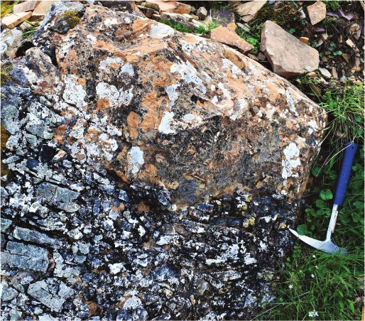
Pagination not final (cite DOI) / Pagination provisoire (citer le DOI)

                                                                                    4                                                                                                                       Can. J. Earth Sci. Vol. 00, 0000

                                                                                    Table 1. Formal definition of the Lone Formation, Hay Creek Group.
                                                                                    Name                 Lone Formation
                                                                                    Name derivation      Named after Lone Mountain within the southeastern Ogilvie Mountains, Yukon Territory, Canada; NTS 116B6
                                                                                    Category and rank    Lithostratigraphic Formation
                                                                                    Type area            Exposures within unnamed drainage networks of the westernmost headwaters of Coal Creek, northwest of Mount Harper,
                                                                                                           Coal Creek inlier, Yukon
                                                                                    Unit type section    Section J1713 (this study)
                                                                                                         Located in the headwaters of an unnamed tributary to the Monster River approximately 12 km north–northwest of Mount
                                                                                                           Harper, Yukon Territory, Canada
                                                                                                         Lower boundary: irregular to sharp contact with matrix-supported conglomerate of the Eagle Creek Formation
                                                                                                           (Macdonald et al. 2018; 64.7870, –140.0717)
                                                                                                         Upper boundary: a sharp-gradational contact with yellow/buff-weathering fine-grained dolograinstone and dolomudstone
                                                                                                           of the Cliff Creek Formation (this study)
                                                                                    Historical list of   Previously referred to as map unit PH1/PH2 of the upper Mount Harper Group by Mustard et al. (1988), Thompson et al.
                                                                                     symbols               (1994), and Mustard and Roots (1997); was subsequently referred to as the undifferentiated Hay Creek Group by
Can. J. Earth Sci. Downloaded from cdnsciencepub.com by 98.216.152.57 on 03/09/21

                                                                                                           Macdonald et al. (2010, 2011, 2013) and Strauss et al. (2014)
                                                                                    Unit description     A highly localized white- to grey-weathering matrix-supported carbonate rudstone or diamictite; the base begins with
                                                                                                           5.4 m of medium- to thick-bedded white-weathering dark grey matrix-supported carbonate clast diamictite with
                                                                                                           subrounded to subangular clasts of oolitic dolograinstone, dolomudstone, stromatolitic doloboundstone, silicified
                                                                                                           carbonate, blue to black chert, and rare quartzite; this is followed by a thin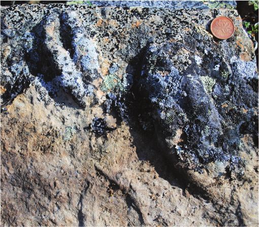
Pagination not final (cite DOI) / Pagination provisoire (citer le DOI)

                                                                                    Busch et al.                                                                                                                                      5

                                                                                    Table 3. Formal definition of the Mount Ina Formation, Rackla Group.
                                                                                    Name                 Mount Ina Formation
                                                                                    Name derivation      Named after Mount Ina located in the southeastern Ogilvie Mountains, Yukon Territory, Canada; NTS 116B5
                                                                                    Category and rank    Lithostratigraphic Formation
                                                                                    Type area            Exposures within unnamed drainage networks of the westernmost headwaters of Coal Creek, northwest of Mount Harper,
                                                                                                           Coal Creek inlier, Yukon
                                                                                    Unit type section    Section F838 (Macdonald et al. 2011, 2013)
                                                                                                         Located along a prominent north–south-trending ridge and saddle approximately 5 km north of Mount Harper, Yukon
                                                                                                           Territory, Canada
                                                                                                         Lower boundary: directly overlies brecciated dolostone beds of the Cliff Creek Formation (this study; 64.726, 140.040)
                                                                                                         Upper boundary: poorly exposed contact with buff-weathering dolostone of the Last Chance Formation (this study;
                                                                                                           64.720010, 140.041317)
                                                                                    Historical list of   Previously referred to as map unit PH3 of the upper Mount Harper Group of Mustard et al. (1988), Thompson et al. (1994),
                                                                                     symbols               and Mustard and Roots (1997); was subsequently classified as part of the “upper group” by (Macdonald et al. 2011, 2013)
                                                                                                           and labeled map unit nPu1 in Strauss et al. (2014)
Can. J. Earth Sci. Downloaded from cdnsciencepub.com by 98.216.152.57 on 03/09/21

                                                                                    Unit description     Generally a thick succession of largely homogenous fissile dark grey to black shale with minor thin (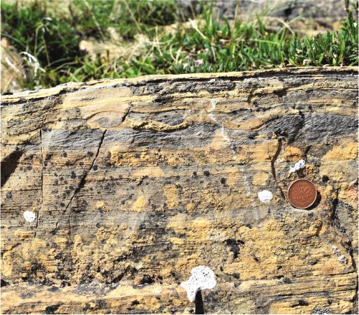
Pagination not final (cite DOI) / Pagination provisoire (citer le DOI)
6 Can. J. Earth Sci. Vol. 00, 0000
Table 4. Formal definition of the Last Chance Formation, Rackla Group.
Name Last Chance Formation
Name derivation Named after Last Chance Creek in the western Ogilvie Mountains, Yukon Territory, Canada; NTS 116C15
Category and rank Lithostratigraphic Formation
Type area Exposures within unnamed drainage networks of the westernmost headwaters of Coal Creek, northwest of Mount Harper,
Coal Creek inlier, Yukon
Unit type section Section JB1704/J1711 (this study)
Located along the northern flank of a prominent north–south-trending ridge approximately 5 km north of Mount Harper,
Yukon Territory, Canada
Lower boundary: first exposure of grey-colored dolostone above subcropping black shale and mudstone of the Mount Ina
Formation (this study; 64.72006, 140.04134)
Upper boundary: sharp contact with brown to yellow-weathering thin- to medium-bedded blue-grey very-fine- to fine-
grained quartz arenite with ripple cross-lamination and minor dolomitic siltstone of the Shade Formation (this study;
64.71945, 140.04172)
Historical list of Previously referred to as map unit PH4 of the upper Mount Harper Group of Mustard et al. (1988), Thompson et al. (1994),
Can. J. Earth Sci. Downloaded from cdnsciencepub.com by 98.216.152.57 on 03/09/21
symbols and Mustard and Roots (1997); was subsequently classified as part of the “upper group” by (Macdonald et al. 2011, 2013)
and labeled map unit nPu2 in Strauss et al. (2014)
Unit description Predominantly a distinctive unit of orange- to tan-weathering dolograinstone interbedded with maroon- to green-
weathering calcareous siltstone and rare intraclast rudstone, but contains two informal members (Gladman and
Fireweed members) with different lithofacies and variable exposures throughout the Coal Creek inlier (see below); basal
contact between recessive black shale and mudstone of Mount Ina Formation and silicified and brecciated dolostone of
the informal Gladman member is sharp to irregular;
Gladman member: localized highly silicified and brecciated orange- to white-weathering dolostone; at the type section of
the Last Chance Formation, this member is not exposed, but ca. 0.36 km to the southeast there are isolated outcrops of
pink- to grey-weathering thin-bedded and brecciated dolostone ca. 9 m above recessive black shale of the uppermost
Mount Ina Formation; the exposure consists of ca. 2 m of pink- to grey-weathering thin-bedded coarsely recrystallized
dolostone before 2.5 m of cover; the upper 3 m is pink-weathering, massive, and coarsely recrystallized dolostone before
15 m of cover preceding exposure of orange-weathering dolograinstone of the type Last Chance Formation; elsewhere,
For personal use only.
strata of the Gladman member are composed of 19.5 m of orange-weathering massive and thick-bedded dolomudstone,
intraclast rudstone, and breccia with pervasive silicification of dolostone facies and distinctive bedding parallel and
cross-cutting quartz veins; there are also “tepee” structures that consist of thin, silicified beds that are fractured and
upwarped and are sometimes overlain by thinly laminated dolograinstone with wave ripple cross-lamination; the upper
contact is marked by a highly irregular erosional surface at the top of the heavily brecciated and silicified dolostone that
variably incises into the upper brecciated rudstone and is draped by tan-orange dolomudstone with reworked clasts
from the underlying strata;
Exposures above the discontinuous Gladman member consist of dark grey siltstone interbedded with 5–10 cm thick
orange- tan-weathering silty dolograinstone with abundant ripple cross-lamination; the silty dolograinstone becomes
dominantly carbonate and thick bedded at 9.3 m with 3–10 cm thick interbeds of grey siltstone; this interval has
abundant hummocky and swaley cross-stratification that continues for much of the section; at 35.3 m, interbeds of
maroon calcareous siltstone appear with the thin- to medium-bedded orange- to tan-weathering dolograinstone and
continues for 6.8 m; this is overlain 14.8 m of light-grey-weathering fine dolograinstone with abundant hummocky and
swaley cross-stratification and minor ripple cross-lamination before a 6 cm thick bed of maroon and grey laterally linked
hemispheroidal stromatolitic doloboundstone (ca. 2–5 cm in diameter) at 56.9 m; the following 12.2 m consists of tan-
grey ripple cross-laminated dolograinstone with 9–15 cm thick interbeds of intraclast rudstone containing gravel- to
cobble-sized tabular clasts within a silty matrix at 58.6 and 61.6 m; the upper 4.7 m of the section consist of covered
intervals (69.7–72.2 and 72.4–74.0 m) with intervening outcrops of grey thin- to medium-bedded fine dolograinstone
interbedded with tan silty dolograinstone; there is 24.2 m of cover before a contact at 98.6 m with the Fireweed Member;
Fireweed member: generally a light to dark grey finely laminated concretionary carbonate unit; at the type section, the
lower contact with the Last Chance Formation is covered for 24.2 m with two patches of subcrop from 90.3–91.2 and
94.6–95.1 m, which consist of interbedded brownish black calcareous shale and nodular fetid lime mudstone; these
strata are overlain by 17.7 m of interbedded calcareous black to grey mudstone with dark grey thin- to medium-bedded
very finely laminated concretionary lime mudstone; carbonate concentric concretions are lozenge- to oblate-shaped, ca.
2–15 cm tall, and ca. 5–95 cm wide; the upper 1.2 m consists of a similar facies that is partially dolomitized before
transitioning at 117.9 m into 3.4 m of brown- to yellow-weathering thin- to medium-bedded blue-grey very-fine- to fine-
grained quartz arenite with ripple cross-lamination and minor dolomitic siltstone of the Shade Formation
Dimensions 117.9 m thick at type section
Geologic age Neoproterozoic (Ediacaran); contains a Re–Os radiometric age of 567.3 Ma 6 3.0 16.3 m above the base of the Fireweed
member at the type section (Rooney et al. 2020); correlated with the Gametrail Formation, which has a Re–Os
radiometric age constraint in the Wernecke Mountains of
Pagination not final (cite DOI) / Pagination provisoire (citer le DOI)

                                                                                    Busch et al.                                                                                                                                   7

                                                                                    Table 5. Formal definition of the Shade Formation, Rackla Group.
                                                                                    Name                 Shade Formation
                                                                                    Name derivation      Named after Shade Creek, located in the western Ogilvie Mountains adjacent to the Alaskan border, Yukon Territory,
                                                                                                           Canada; NTS 116C15
                                                                                    Category and rank    Lithostratigraphic Formation
                                                                                    Type area            Exposures within unnamed drainage networks of the westernmost headwaters of Coal Creek, northwest of Mount Harper,
                                                                                                           Coal Creek inlier, Yukon
                                                                                    Unit type section    Section J1708 (this study)
                                                                                                         Located along the northern flank of a prominent north–south-trending ridge ca. 5 km north of Mount Harper, Yukon
                                                                                                           Territory, Canada
                                                                                                         Lower boundary: sharp contact with peach-colored dolostone of the Last Chance Formation (this study; 64.79142001,
                                                                                                             140.144478)
                                                                                                         Upper boundary: sharp and locally erosional contact with massive clast-supported conglomerate of the Shell Creek
                                                                                                           Formation (this study; 64.782488, 140.11849)
                                                                                    Historical list of   Previously referred to as the uppermost part of unit PH4 of the upper Mount Harper Group of Mustard et al. (1988),
Can. J. Earth Sci. Downloaded from cdnsciencepub.com by 98.216.152.57 on 03/09/21

                                                                                     symbols               Thompson et al. (1994), and Mustard and Roots (1997); was subsequently classified as part of the “upper group” by
                                                                                                           (Macdonald et al. 2011, 2013) and labeled map unit nPu3 in Strauss et al. (2014)
                                                                                    Unit description     Generally a brown- to yellow-weathering thin- to medium-bedded blue-grey very-fine- to fine-grained sandstone succession
                                                                                                           with ripple cross-lamination and minor dolomitic siltstone; at the type section, the lower contact with the Last Chance
                                                                                                           Formation is sharp and begins with shale overlying peach-weathering massive dolostone; this is succeeded by 90.9 m
                                                                                                           of semi-continuous exposure of brown- to yellow-weathering, dark grey – green very-fine-grained quartz arenite to
                                                                                                           sublitharenite interbedded with brownish grey siltstone and minor shale; sandstone horizons are occasionally
                                                                                                           dolomite-cemented and contain normal grading, ripple cross-lamination, occasional flute casts, and distinct Bouma Tcde
                                                                                                           subdivisions; at 90.9 m, there is 7.3 m of cover succeeded by 4.8 m of brown-green micaceous very-fine- to medium-grained
                                                                                                           lithic arenite interbedded with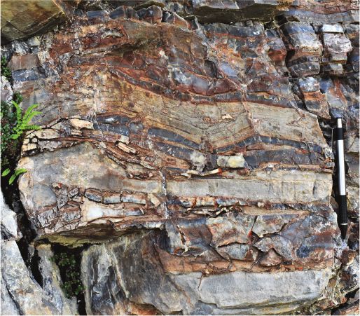
Pagination not final (cite DOI) / Pagination provisoire (citer le DOI)
8 Can. J. Earth Sci. Vol. 00, 0000
Table 6. Formal definition of the Shell Creek Formation.
Name Shell Creek Formation
Name derivation Named after Shell Creek within the southwestern Ogilvie Mountains, Yukon Territory, Canada; NTS 116C09
Category and rank Lithostratigraphic Formation
Type area Exposures within unnamed drainage networks of the westernmost headwaters of Coal Creek, northwest of Mount Harper,
Coal Creek inlier, Yukon
Unit type section Section JB1702 (this study)
Located in the headwaters of an unnamed tributary to the Monster River approximately 14 km north–northwest of Mount
Harper, Yukon Territory, Canada
Lower boundary: erosional contact with black shale and dark grey siltstone of the underlying Mount Ina Formation (this
study; 64.794970, 140.135514)
Upper boundary: sharp contact with light grey thick-bedded dolograinstone of the Bouvette Formation (Morrow 1999;
64.69087, 140.11849).
Historical list of Previously referred to as the uppermost part of unit PH5 of the upper Mount Harper Group of Mustard et al. (1988),
symbols Thompson et al. (1994), and Mustard and Roots (1997); was subsequently classified as “Cambrian Undivided” in
Can. J. Earth Sci. Downloaded from cdnsciencepub.com by 98.216.152.57 on 03/09/21
(Macdonald et al. 2011, 2013) and map unit nPu3 in Strauss et al. (2014)
Unit description Generally consists of interbedded medium- to thick-bedded, fine- to coarse-grained lithic arenite to quartz arenite, pebble
to cobble conglomerate, and siltstone or shale; in the type section, the base of the unit is marked by a prominent erosional
contact and begins with 3.2 m of thinly bedded and poorly sorted medium-grained lithic wacke with thin interbeds of
subrounded to well-rounded granule to pebble clast-supported conglomerate; conglomerate clasts are crudely imbricated
and consist of chert, quartzite, and volcanic lithologies; this is succeeded by 0.4 m of dark-brown-weathering siltstone and
2.8 m of trough cross-stratified medium-grained lithic wacke and poorly sorted medium- to coarse-grained lithic arenite; this
is overlain by 0.3 m of trough-cross stratified chert pebble conglomerate with subrounded to well-rounded granule- to
pebble-sized clasts with a fine- to medium-grained sandy matrix; the next 7.1 m of strata consist of thick-bedded fine- to
medium-grained lithic wacke with thin interbeds of grey–green siltstone and discontinuous lenses of chert pebble
conglomerate; 13.8 m above the base of the Formation there is a sharp contact with 2.4 m of grey–green trough cross-
stratified fine- to medium-grained lithic arenite interbedded with siltstone; the bases of beds contain abundant syneresis
cracks, indeterminate burrows, and Cruziana, Diplocraterion, Rusophycus, and Planolites trace fossils; these strata are overlain
For personal use only.
by 6.2 m of trough cross-stratified fine-grained sublitharenite interbedded with siltstone; this is followed by a 20.8 m thick
covered interval of dolostone rubble before an abrupt contact with light grey thin-bedded dolostone of the Bouvette
Formation
Dimensions 43.2 m thick at type section.
Unit reference JB1809 (this study; 64.68953, 140.11682).
section ca. 144 m thick succession of thin- to medium-bedded grey to brown medium- to fine-grained sublitharenite; the base of
the section is marked by more resistant outcrops of sandstone in contact with recessive black shale and grey siltstone of
the Mount Ina Formation; above the lower contact, there is 121.5 m of thin- to medium-bedded sublitharenite that
contains abundant ripple cross lamination, stoss-preservational ripples, and a 0.6 m thick interval of orange-weathering
silty dolostone at 105.0 m; there is 18.0 m of thinly bedded medium- to coarse-grained sublitharenite before 25 m of
recessive black- to orange-colored shale and siltstone beneath a sharp contact with massive light grey recrystallized
dolostone of the Bouvette Formation
Geologic age Cambrian (Terreneuvian–Miaolingian) based on trace fossil assemblages (Mustard et al. 1988; Gabriela Mángano and
Buatois 2017)
Regional Slats Creek Formation (Fritz 1985), Taiga Formation (Bell 1986), Illtyd Formation (Bell 1986), Gull Lake Formation (Gordey
correlations and Anderson 1993), and unnamed conglomerate (Busch et al. 2019) of the Wernecke and Mackenzie mountains, Yukon
and Northwest Territories, Canada
At the base of the Last Chance Formation, the newly defined rudstone, and rare stromatolitic doloboundstone. The base of this
and informal Gladman member (Table 4) consists of discontinuous package (up to ca. 75 m) may include minor siltstone and silty
thin- to medium-bedded dolomudstone with bedding-parallel and dolograinstone. Above this is a transition into thin- to thick-
cross-cutting quartz veins, variable silicification, and distinctive bedded tan-weathering fine-grained dolograinstone with perva-
“tepee” structures (Kendall and Warren 1987). These tepee struc- sive SCS and HCS (Fig. 5E) and minor ripple cross-lamination
tures are marked by the fracturing, buckling, and up-warping of (Fig. 5F). There are several intervals of bright maroon- and green-
thin dolomudstone beds (ca. 1–2 cm), and they are commonly weathering calcareous siltstone, interbedded with the tan dolog-
highly silicified (Fig. 5C). The Gladman member also contains rainstone strata, as well as several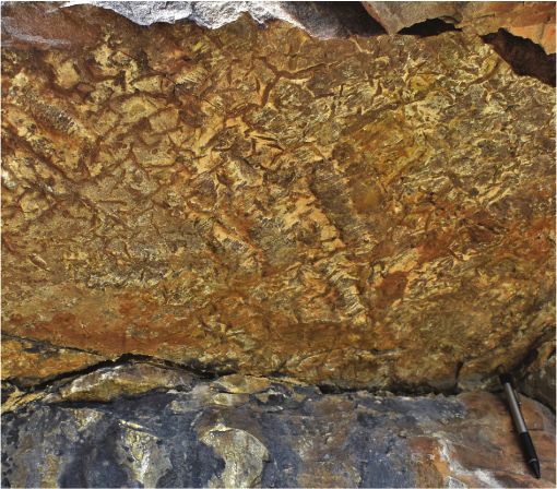
Pagination not final (cite DOI) / Pagination provisoire (citer le DOI)
Busch et al. 9
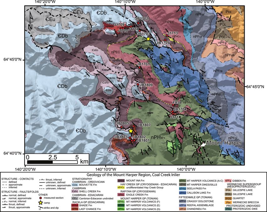
Fig. 3. Geological map of the Mount Harper Region, Coal Creek inlier, Yukon, showing measured stratigraphic sections and camp
locations for this study. Map created using ESRI ArcGIS version 10.7.1 and is modified from Strauss et al. (2014). Shaded relief elevation
data courtesy of Natural Resources Canada. [Color online.]
Can. J. Earth Sci. Downloaded from cdnsciencepub.com by 98.216.152.57 on 03/09/21
For personal use only.
and dolostone with lozenge- to oblate-shaped concretions that of carbonate in voids, enlarging fractures and eventually buck-
are ca. 2–15 cm tall and ca. 5–95 cm wide with rare internal laminae ling the overlying carbonate sediment (e.g., Assereto and Kendall
(Figs. 8B, 8C). Dolomitization of these strata is highly localized, of- 1977). In addition, the presence of intraclast rudstone beds,
ten associated with a color change from dark grey to tan/orange, which are commonly thought to form during storm wave action
and is most prominent where the sub-Shell Creek unconformity or reworking of shoreline deposits in peritidal or subtidal set-
incises into the concretionary carbonate interval. These concre- tings (e.g., Myrow et al. 2004), indicate deposition above maxi-
tionary carbonate strata also host discontinuous ca. 0.5 m thick mum storm wave base. A shallow-water setting is supported by
intervals or lenses of soft-sediment deformation and intraclast widespread silicification of the carbonate facies, which is a com-
rudstone. Carbonate strata of the Last Chance Formation are dis- mon phenomenon observed in proximity to exposure surfaces
conformably overlain by the siliciclastic-dominated Shade Forma- in Precambrian carbonate successions (e.g., Maliva et al. 2005;
tion in the southern part of the study area and unconformably Skotnicki and Knauth 2007). Finally, the irregular relief at the
overlain by the Shell Creek Formation in the northernmost strati- Gladman member’s upper contact shares many characteristics
graphic sections (Figs. 6, 7). with “scalloped” erosional surfaces documented in other subae-
rial exposure surfaces on carbonate platforms (e.g., Read and
Grover 1977); thus, the Gladman member probably records shoal-
Depositional setting and age ing from a shallow marine or peritidal environment to an emer-
The sedimentological characteristics of the Gladman member gent subaerial environment.
of the Last Chance Formation indicate subtidal to supratidal In contrast, the majority of lithofacies in the overlying parts of
sedimentation along the inner shelf of a carbonate platform or the Last Chance Formation indicate sedimentation on a storm-
ramp. Tepee structures are often associated with peritidal envi- dominated carbonate ramp. The predominance of fine-grained
ronments where intense evaporation causes rapid precipitation dolograinstone with amalgamated HCS/SCS indicates deposition
Published by NRC Research Press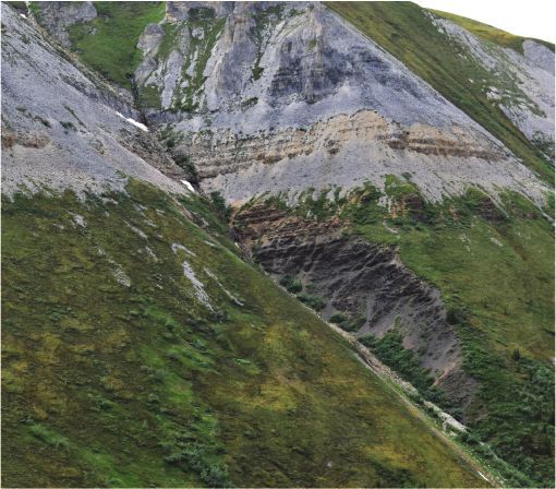
Pagination not final (cite DOI) / Pagination provisoire (citer le DOI)
10 Can. J. Earth Sci. Vol. 00, 0000
Fig. 4. Stratigraphic fence diagram of the Lone, Cliff Creek, and basal Mount Ina formations. Thin exposures of the Lone Formation were
documented in both sections, while the interbedded nature of the Lone and Cliff Creek formations was only documented at the type
section (J1713). In both measured sections, dolostone is eventually succeeded by black shale of the Mount Ina Formation, but this
transition is only well exposed at section J1713. HCS/SCS, hummocky and swaley cross-stratification. [Color online.]
5 km LITHOFACIES AND SYMBOLOGY
NW SE carbonate-clast
J1713 diamictite
31.5
cross-laminated silty
dolograinstone
Mount Ina
thinly-laminated
Formation 20 dolograinstone
JB1701 dolomudstone
Cliff Creek top not exposed
Can. J. Earth Sci. Downloaded from cdnsciencepub.com by 98.216.152.57 on 03/09/21
10
Formation 4 shale/mudstone
0m
Lone Formation cover
Co dst tsto
Lim glom e
Gr e-/D rate
Ru nds e
Co
Sh er
Sa /S
Re sto ne
Bo sto - m
ain olo
0m
ale
n il
n on ne
d
v
u
cry ne
HCS/SCS
sta
Co dst tsto
Lim glom e
Gr e-/D rate
Ru nds e
Co
Sh er
Sa le/S
Redsto one
Bo to - m
t o
n
e
lliz
ain olo
a
n il
n on ne
v
u
cry ne
ripple cross-lamination
ed
s
sta
ud
t
n
e
lliz
trochoidal bedforms
sto
ed
ne
ud
sheet crack cements
sto
ne
pyrite
For personal use only.
under combined flow conditions above storm wave base (e.g., with underlying peach dolostone of the Last Chance Formation
Duke 1985; Nøttvedt and Kreisa 1987). The occurrence of rare (section J1711, Fig. 7; Rooney et al. 2020).
beds of reworked intraclast rudstone is also suggestive of deposi-
tion above maximum storm wave base (e.g., Myrow et al. 2004). Shade Formation (new), Rackla Group (Ediacaran)
The occurrence of small hemispheroidal stromatolites and inter- Lithostratigraphy
vening calcareous siltstone facies in the Last Chance Formation Fine-grained siliciclastic rocks of the Shade Formation discon-
may indicate episodic deepening into the mid-outer ramp rela- formably overlie carbonate strata of the Last Chance Formation
tive to the HCS-dominated and amalgamated dolograinstone, (Table 5). This unit was previously referred to as the uppermost
which were deposited in an inner ramp setting, or they may sim- part of unit PH4 of the upper Mount Harper Group of Mustard
ply reflect background quiescent sedimentation within the (1988), Thompson et al. (1994), and Mustard and Roots (1997) and
inner-middle ramp setting. The occurrence of abundant cross- part of the “upper group” by Macdonald et al. (2011, 2013). Strata
stratified grainstone is similar to other Ediacaran storm-domi- of the Shade Formation at the type section consist of 103 m of
nated carbonate margins, such as the Nama Group of Namibia poorly exposed brown- to yellow-weathering siltstone and shale/
(Dibenedetto and Grotzinger 2005). mudstone interbedded with very-fine-grained quartz arenite
The laminated concretionary facies of the Fireweed member and sublitharenite (Fig. 7). This siliciclastic package is in places
probably records suspension sedimentation beneath maximum dolomite cemented and contains normal grading, ripple cross-
storm wave base in an outer shelf setting. The formation of car- lamination, occasional flute casts, and rare full to abbreviated
bonate concretions is thought to occur during early diagenesis Bouma subdivisions (Bouma 1962). The Shade Formation was
and could be related to microbial processes (e.g., Berner 1968; only observed in two measured sections and in most locations
Raiswell 1976) or mixing between meteoric and marine pore- is absent beneath the sub-Shell Creek unconformity (Fig. 7). In
waters (e.g., Hudson and Friedman 1974). Soft-sediment deforma- all measured sections, the Formation’s upper contact is marked
tion may occur from buoyancy instability due to deposition of by an erosional contact with up to 2 m of relief beneath siliciclas-
material with density contrasts, downslope shear from slumping tic rocks of the Cambrian Shell Creek Formation (Fig. 7).
or slope failure, fluid escape from post-depositional compaction
or seismicity, or syn-depositional current shear from turbidity Depositional setting and age
currents (Gladstone et al. 2018). There is no indication of tur- The fine-grained siliciclastic strata of the Shade Formation
bidity current flow or coherent structures indicating downslope may record evidence of upper slope sedimentation due to the
slumping in these carbonate-dominated strata, so buoyancy insta- presence of partial to full Bouma sequence turbidites and flute
bility or fluid escape are favored interpretations. There is also the casts. The Formation’s general poor exposure in the Coal Creek
localized presence of discontinuous intraclast rudstone intervals, inlier precludes a detailed reconstruction of its depositional
which suggest reworking by rare storm-generated events. environment, but this siliciclastic package probably records a
The Last Chance Formation hosts a large negative carbon deepening relative to the underlying concretionary carbonate
isotope excursion that has been correlated globally with the unit of the Fireweed member, perhaps from an outer shelf to a
ca. 567–574 Ma Shuram carbon isotope excursion (Macdonald upper slope setting that is dominated by sediment gravity-flow
et al. 2013; Rooney et al. 2020). The depositional age of the Fire- processes. There are no absolute age constraints for the Shade
weed member has recently been constrained by a Re–Os age of Formation in the Coal Creek inlier; however, its stratigraphic
567.3 6 3.0 Ma, which was obtained 16.4 m above the contact position overlying the ca. 567 Ma Fireweed member (Rooney
Published by NRC Research PressPagination not final (cite DOI) / Pagination provisoire (citer le DOI)
Busch et al. 11
Fig. 5. (A) Matrix-supported carbonate clast diamictite of the Lone Formation; rock hammer is 33 cm in length. (B) Cliff Creek
Formation silicified dolostone with “giant wave ripples” disrupted by sheet crack cements; hammer is 33 cm in length. (C) Tepee
structures within silicified dolostone of the Gladman member (Last Chance Formation); pencil is 13 cm in length. (D) Irregular contact
between silicified and brecciated dolostone of the upper Gladman member and dolomudstone of the Last Chance Formation; hammer
is 33 cm in length. (E) Hummocky cross-stratified dolograinstone of the Last Chance Formation; hammer is 33 cm in length. (F) Silty
dolograinstone with hummocky cross-stratification and ripple cross-lamination in the Last Chance Formation; coin is 1.8 cm in
diameter. [Color online.]
A B
Can. J. Earth Sci. Downloaded from cdnsciencepub.com by 98.216.152.57 on 03/09/21
C D
For personal use only.
E F
et al. 2020) and below the Cambrian Shell Creek Formation is no more than 45 m thick and unconformably overlies siltstone
suggests this unit was deposited in the late Ediacaran to early of the Shade Formation, carbonate of the Last Chance Formation,
Cambrian (section J1711, Fig. 7; Rooney et al. 2020). or black shale/mudstone of the Mount Ina Formation (Fig. 9). Shell
Creek strata in this location consist of interbedded medium- to
Cambrian Shell Creek Formation (new) thick-bedded fine- to very-coarse-grained sandstone, pebble to cobble
Lithostratigraphy conglomerate, and siltstone/shale (Fig. 9). Dark-grey-weathering
The Shell Creek Formation overlies a major erosional surface conglomerate intervals are composed of locally imbricated sub-
in the Coal Creek inlier (herein referred to as the sub-Shell Creek rounded to well-rounded granule- to pebble-sized clasts of chert,
unconformity) and consists of interbedded shale, siltstone, sand- quartzite, and mafic volcanic rocks with crude cross-stratification
stone, and conglomerate (Table 6, Fig. 9). This unit was previously (Figs. 8D, 8G, 8H). Conglomerate packages are commonly inter-
referred to as unit PH5 of the upper Mount Harper Group of bedded with grey–green siltstone, shale, and trough cross-stratified
Mustard (1988), Thompson et al. (1994), and Mustard and Roots fine- to medium-grained lithic arenite and sublitharenite (Figs. 8E,
(1997); it was subsequently classified as “Cambrian Undivided” by 8G), the bases of which contain syneresis cracks and Cruziana,
Macdonald et al. (2011, 2013). The Shell Creek Formation displays Diplocraterion, Rusophycus, and Planolites trace fossils (Figs. 6A, 6B;
significant facies variation and thickness changes across the Mustard et al. 1988). Bedding geometries are commonly lenticular
study area. In the northern part of the Coal Creek inlier, this unit to stratiform with local irregular bases, and in some cases form
Published by NRC Research PressPagination not final (cite DOI) / Pagination provisoire (citer le DOI)
12 Can. J. Earth Sci. Vol. 00, 0000
Fig. 6. (A) Base of a sandstone bed in the Shell Creek Formation with abundant complex trace fossils, including Cruziana (red arrows),
Planolites, and other indeterminate ichnogenera; pencil in yellow is 13 cm long. (B) Rusophycus trace fossils on a float block from the Shell
Creek Formation; coin is 1.8 cm in diameter. (C) Measured section JB1702 in the northern part of the study area where proximal facies of
the Shell Creek Formation sit unconformably on the Mount Ina Formation. (D) Measured section JB1809 in the western part of the study
area where distal facies of the Shell Creek Formation rest unconformably on the Mount Ina Formation. (E) Measured sections JB1704/
J1711 of the Last Chance Formation overlying the type section of the Mount Ina Formation (F838, Macdonald et al. 2013). (F) Measured
section JB1703 where the Shell Creek Formation sits unconformably on the Last Chance Formation. [Color online.]
A B
Can. J. Earth Sci. Downloaded from cdnsciencepub.com by 98.216.152.57 on 03/09/21
C D
Bouvette JB1809
Formation
Bouv
ette F
m
Shell Creek
Formation Shell
Creek
Fm
Mount Ina
For personal use only.
Formation Moun
JB1702 Form t Ina
ation
E Fireweed member
F
Last Chance
Formation
B
Foouv
JB1704/J1711 Sh rm ett
el ati e
Mount Ina lC on
Formation L re
Chast ek
an Fm
Cliff Creek Fm M ce
Fo ou Fm
rm nt
Eagle Creek Fm at Ina
io
n
JB1703
amalgamated bed-sets up to ca. 1.5 m thick (Fig. 8G). There is a trace fossils were not observed in these strata. The top of the
general fining-upwards trend in these coarser-grained facies of the Shell Creek Formation is marked by a ca. 25 m thick interval of
Shell Creek Formation, where the conglomerate and sandstone recessive black- to orange-weathering shale and siltstone,
facies are generally succeeded by siltstone and shale beneath the which outcrops beneath massive light grey dolostone of the
overlying Bouvette Formation (Fig. 9). Bouvette Formation.
In the southern part of the Coal Creek inlier, the thickness of
the Shell Creek Formation increases by over a factor of three to a Depositional setting and age
maximum of ca. 165 m (Figs. 3, 9). Here, the unit unconformably Cross-stratified conglomerate and sandstone facies of the
overlies either carbonate of the Last Chance Formation, or black northern Shell Creek exposures are interpreted to be marginal
shale of the Mount Ina Formation. Shell Creek lithofacies in marine in origin. Paleocurrent indicators from sandstone and
these sections consist of thin- to medium-bedded grey to brown conglomerate horizons in this unit indicate paleoflow ranging
fine- to medium-grained sublitharenite and siltstone with abundant from northerly to westerly (present-day coordinates), although
ripple cross-lamination, occasional stoss-preservational structures, an overall northerly trend was reported by Mustard (1990). The
and common normal graded sandstone horizons with ero- polydirectional inclination of the foresets observed in the trough
sional bases (Fig. 8F). Siltstone typically occurs as partings or cross-stratified sandstone may indicate a tidal or oscillatory
drapes between thin beds of fine-grained sandstone. Notably, wave-current influence; thus, we interpret these coarser-grained
Published by NRC Research PressPagination not final (cite DOI) / Pagination provisoire (citer le DOI)
Busch et al. 13
Fig. 7. Stratigraphic fence diagram of the Shade, Last Chance, and Mount Ina formations beneath the sub-Shell Creek unconformity. At
least ca. 190 m of strata is truncated by the sub-Shell Creek unconformity at section JB1702, while preservation of the majority of the
Ediacaran succession occurs at section JB1802. Broadly, the sub-Shell Creek unconformity incises more strata to the northwest compared
with the southeast in the study area. [Color online.]
1.0 km 0.8 km 1.6 km 2.7 km 7.1 km 4.0 km 1.5 km 0.1 km
NW SE
sub-Shell Creek J1709,
unconformity J1710 J1708 JB1702 JB1703 JB1705 J1711, JB1704 JB1807 JB1802
100 120 29.2 97.0 top not exposed 117.8
60
Shade top not
120
exposed 0m
70.3 80 100
Fireweed 100
Cover
Shale/Siltstone
Sandstone
Conglomerate
Lime-/Dolo- mudstone
Grainstone
80
member 60 40
100
60 80
80
60
Last 40 20
Can. J. Earth Sci. Downloaded from cdnsciencepub.com by 98.216.152.57 on 03/09/21
Chance 80
40 60
60
40 0m
20
60
Cover
Shale/Siltstone
Sandstone
Conglomerate
Lime-/Dolo- mudstone
Grainstone
Gladman
member 20 40
0m 40
20
40
Cover
Shale/Siltstone
Sandstone
Conglomerate
Lime-/Dolo- mudstone
Grainstone
Boundstone
Rudstone
Mount Ina 0m JB1801 20
0m 16.8
Cover
Shale/Siltstone
Sandstone
Conglomerate
Lime-/Dolo- mudstone
Grainstone
Rudstone
Recrystallized
20
Cover
Shale/Siltstone
Sandstone
20
0m 0m
0m
Cover
Shale/Siltstone
Sandstone
Conglomerate
Lime-/Dol- mud.
Grainstone
Rudstone
Recrystallized
Cover
Shale/Siltstone
Sandstone
Conglomerate
Lime-/Dolo- mudstone
Grainstone
Rudstone
Cover
Shale/Siltst.
Sandstone
Conglom.
L/D mudst.
0m
For personal use only.
Cover
Sh./Siltst.
Sandst.
Congl.
Grainst.
Rudst.
Boundst.
L/D mud.
LITHOFACIES AND SYMBOLOGY
ripple cross-laminated recrystallized dolostone microbialitic doloboundstone
sandstone
planar-laminated silty dolomudstone cover
sandstone
finely-laminated concretionary stromatolitic doloboundstone
siltstone lime/dolomudstone fault
shale/mudstone hummocky cross-stratified silty subaerial exposure surface
dolograinstone
tepee structure
intraclast rudstone/breccia silty dolomudstone
tectonic folding
deposits to reflect sedimentation within a wave-influenced del- age for the Bouvette Formation. As a result, the potential age range
taic system. These coarse-grained strata could alternatively com- of the Shell Creek Formation extends from the Terreneuvian to the
prise subaqueous marine fan delta deposits, but the consistent Miaolingian.
thickness of these strata and the distance over which they transi-
tion to finer-grained facies argues against this interpretation. d13Ccarb and d18Ocarb chemostratigraphy
The ripple cross-lamination and stoss-preservational ripples in The Cliff Creek Formation has d13Ccarb values that begin at
the southern exposures, some of which resemble combined- 0.5% and decrease incrementally to a minimum of 3.7%,
flow bed configurations of Arnott and Southard (1990; Fig. 8F), before returning to 3.0% in the highest exposure (Fig. 10; also
indicate deposition by oscillatory and combined-flow regimes and see data in Ahm et al. 2019). The d18Ocarb data from these strata av-
are interpreted to represent deposition in a wave-influenced fluvio- erage 6.6% and display a strong positive correlation with the
deltaic to shallow marine environment (e.g., Raaf et al. 1977). d13Ccarb values (r = 0.58). The Gladman member of the Last Chance
The diagnostic trace fossils Cruziana, Rusophycus, and Diplocraterion Formation has a range of d13Ccarb values between 2.7% and
provide a maximum depositional age for the Shell Creek Formation 4.8% (Fig. 10) and attendant d18Ocarb values are from 1.3% to
of Cambrian Stage 2 (Terreneuvian; Mustard et al. 1988; MacNaughton 5.5% with no obvious trend, except for an abrupt decrease
and Narbonne 1999; Gabriela Mángano and Buatois 2017). The Shell to 5.6% at the contact with the overlying Last Chance Forma-
Creek Formation directly underlies the Bouvette Formation, where tion. Gladman member d18Ocarb and d13Ccarb values have a strong
the occurrence of putative archeocyathids (Thompson et al. 1994; positive correlation (average correlation coefficient for all sec-
Mustard and Roots 1997) suggest an upper age constraint of Cam- tions = 0.77). The d13Ccarb values are highly depleted in the Last
brian Stage 4 (Series 2; Zhuravlev and Wood 1996; Rowland and Chance Formation and range from 3.1% to 9.3%, with a nadir
Shapiro 2002); however, the fossil report of Fritz (1982) from this lo- at the base of the Formation (directly above the Gladman mem-
cality suggests these specimens are reworked with specimens ber, where present). Carbon isotope values of the Last Chance
of Tabulaconus spp. and coral-like forms that resemble Halysites, Formation tend to gradually increase to more enriched values
thereby providing an ambiguous Furongian maximum depositional and then rapidly transition to highly positive values of 5.3% in
Published by NRC Research PressPagination not final (cite DOI) / Pagination provisoire (citer le DOI)
14 Can. J. Earth Sci. Vol. 00, 0000
Fig. 8. (A) Hummocky cross-stratified silty dolograinstone interbedded with a single bed of stromatolitic doloboundstone (red arrow) in
the upper Last Chance Formation (camera lens cap is 6 cm in diameter). (B) Finely laminated dolomudstone with lozenge-shaped
concretions (red arrows) in the Fireweed member of the Last Chance Formation; hammer is 33 cm long. (C) Plan view of a large
carbonate concretion within the Fireweed member; hammer is 33 cm long. (D) Crudely stratified polymict cobble conglomerate with
imbricated clasts interbedded with siltstone of the Shell Creek Formation; hammer is 33 cm long. (E) Trough cross-stratified sandstone
interbedded with recessive siltstone of the Shell Creek Formation; hammer is 33 cm long. (F) Planar and cross-laminated fine-grained
sandstone with local starved ripples in the Shell Creek Formation; coin is 2.5 cm in diameter. (G) Planar laminated and trough cross-
stratified pebble conglomerate and sandstone of the Shell Creek Formation; pencil is 13 cm long. (H) Polymict conglomerate of the Shell
Creek Formation; coin is 1.8 cm in diameter. [Color online.]
A B
Can. J. Earth Sci. Downloaded from cdnsciencepub.com by 98.216.152.57 on 03/09/21
C D
For personal use only.
E F
G H
Published by NRC Research PressYou can also read