Continuously Operating Reference Station "CORS : History, Applications, and Future Enhancements
←
→
Page content transcription
If your browser does not render page correctly, please read the page content below
Continuously Operating Reference Station „CORS…:
             History, Applications, and Future Enhancements
                                           Richard A. Snay1 and Tomás Soler, M.ASCE2

Abstract: The National Oceanic and Atmospheric Administration’s National Geodetic Survey !NGS" manages the National Continuously
Operating Reference Station !CORS" system that comprises a network of over 1,350 sites, each containing a geodetic quality Global
Navigation Satellite System receiver. This network is currently growing at a rate of about 15 sites per month. NGS collects, processes, and
distributes data from these sites in support of high-accuracy three-dimensional positioning activities throughout the United States, its
territories, and a few foreign countries. CORS data are also used by geophysicists, meteorologists, atmospheric and ionospheric scientists,
and others in support of a wide variety of applications. This paper addresses the history of the CORS network, some of its applications,
and plans for enhancing it within the next few years.
DOI: 10.1061/!ASCE"0733-9453!2008"134:4!95"
CE Database subject headings: Satellites; Geodetic surveys; History.

Historical Introduction                                                     niques provided positional coordinates with relative accuracies of
                                                                            approximately 1:250,000 among the primary horizontal reference
The history of the Continuously Operating Reference Stations                stations in the NSRS. GPS, on the other hand, easily yields rela-
!CORS" system is intimately connected to the National Oceanic               tive accuracies exceeding 1:1,000,000. In addition, because of the
and Atmospheric Administration’s !NOAA’s" National Geodetic                 line-of-sight requirement, many of the older reference stations
Survey !NGS" and this agency’s mission to define, maintain, and             had been installed in locations, like mountain tops, which are
provide access to the U.S. National Spatial Reference System                difficult to access.
!NSRS". The NSRS constitutes the official system of the civilian                NGS first applied GPS to determine positional coordinates for
government for enabling a user to determine geodetic latitude,              the brass disks and other monuments that served as traditional
longitude and height, plus orthometric height, geopotential, accel-         reference stations. Starting with Tennessee in 1987, NGS collabo-
eration of gravity, and deflection of the vertical at any point             rated with various state and federal agencies and others to estab-
within the United States and its territories. The NSRS contains             lish a high accuracy reference network !HARN"—also called a
information about its orientation and scale relative to international       high precision geodetic network—in each of the 50 states. For
reference frames, as well as the precise orbits of all satellites used      each HARN survey, many new reference marks were positioned
in defining or accessing the NSRS. Last, the NSRS also contains             so that, as compared to the preexisting reference marks, the new
all necessary information to describe how all of these quantities           ones would be located in more accessible places !e.g., near public
change over time. The NSRS is crucial for meeting our nation’s              roads" and/or they would provide a relatively less obstructed view
economic, social, and environmental needs.                                  of the sky. These statewide HARNs were embedded into a more
    NGS recognized the potential contributions of the Global Po-            accurate sparse nationwide network whose points were also posi-
sitioning System !GPS" for enhancing the NSRS in the early                  tioned using GPS techniques, first in 1987 and again in 1990
stages of GPS development. Hence, in the late 1980s, this agency            !Soler et al. 1992". Once a HARN survey was completed in a
embarked on applying GPS instrumentation and field techniques               particular state, NGS performed a statewide readjustment of the
to improve the NSRS. NGS quickly converted its traditional hori-            HARN data, together with all archived classical geodetic surveys
zontal field operations !which applied line-of-sight instruments"           and local GPS projects performed in that state, to compute con-
to three-dimensional !3D" field operations using GPS instrumen-             sistent positional coordinates for the associated ground marks.
tation. Snay !1989" reported that traditional line-of-sight tech-               Anticipating the need to perform accurate HARN surveys,
                                                                            NGS introduced, in the fall of 1986, the Cooperative International
   1
     Chief, Spatial Reference System Division, National Geodetic Survey,    GPS Network !CIGNET" !Chin et al. 1987", the forerunner of the
NOS, National Oceanic and Atmospheric Administration, 1315 East-West        CORS network. Each CIGNET site was equipped with a high-
Hwy., Silver Spring, MD 20910. E-mail: Richard.Snay@noaa.gov                quality dual frequency GPS receiver that continuously recorded
   2
     Chief Technical Officer, Spatial Reference System Division,            signals from GPS satellites. The primary intention was to make
National Geodetic Survey, NOS, National Oceanic and Atmospheric             dependable tracking data available from a network of ground sta-
Administration, 1315 East-West Hwy., Silver Spring, MD 20910.               tions to compute precise ephemeredes !orbits" for the GPS satel-
E-mail: Tom.Soler@noaa.gov
                                                                            lites. In 1989, CIGNET contained three stations in the United
   Note. Discussion open until April 1, 2009. Separate discussions must
be submitted for individual papers. The manuscript for this paper was       States !MOJA in Mojave, Calif.; RICH in Richmond, Fla.; and
submitted for review and possible publication on May 18, 2007; approved     WEST in Westford, Mass.". These early CORS were equipped
on April 21, 2008. This paper is part of the Journal of Surveying Engi-     with Mini-Mac 2816-AT dual-frequency codeless receivers !Aero
neering, Vol. 134, No. 4, November 1, 2008. ©ASCE, ISSN 0733-9453/          Service Division, Western Geophysical Company of America,
2008/4-95–104/$25.00.                                                       Houston". In 1990, CIGNET expanded into the southern hemi-

                                                                      JOURNAL OF SURVEYING ENGINEERING © ASCE / NOVEMBER 2008 / 95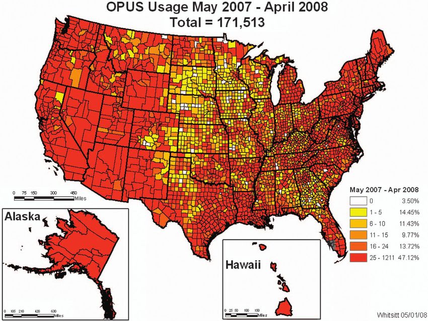
sphere. By the end of 1991, CIGNET comprised a total of 21 sites erage in Texas. By 1996 the number of CORS sites had increased
spanning all continents except Antarctica. As is now the case, all to 85. By making contact with interested agencies and arranging
tracking data were collected by several partners and made freely to exchange data, NGS expanded the network to 108 sites by
available to GPS investigators through NGS archives !Sche- December 1997. The 200-site milestone was surpassed in 2000,
newerk et al. 1990". Gradually, NGS augmented the CIGNET and since then the CORS network has grown to its current size of
network, generating the core of the first public global GPS net- approximately 1,350 sites, and it continues to grow in importance
work that, unknowingly at the time, evolved into the current In- as the primary way for the geodetic-surveying community to ac-
ternational Global Navigation Satellite System !GNSS" Service cess the NSRS. At present, the CORS network contains stations in
!IGS" network under the auspices of the International Association the United States, Canada, Mexico, Central and South America,
of Geodesy. the Caribbean, and Iraq. More than 200 organizations participate
The concept of covering the entire United States with a net- in the program. Recently some sites of EarthScope’s Plate Bound-
work of CORS to enhance the NSRS was first postulated by ary Observatory !PBO", established in the western part of the
Strange !1994". Soon after, Strange and Weston !1995" published North American continent to detect crustal motions, have been
a preliminary description of the CORS system. Around this same incorporated into the CORS network.
time, several other federal agencies were also starting to establish Although the number of CORS sites is currently growing
networks of continuously operating GPS base stations, but for at a rate of about 15 sites per month, the total number of perma-
different reasons. The U.S. Coast Guard !USCG" wished to nent GPS tracking stations in the United States is probably grow-
supplement its LORAN radionavigation service by offering the ing perhaps twice as fast. An ongoing project, that may take
differential GPS !DGPS" service to support safe marine naviga- several years to complete, is to determine an accurate orthometric
tion in U.S. coastal waters. Similarly, the U.S. Army Corps of height for each CORS site. Determining the orthometric height of
Engineers !USACE" sought a cost efficient navigation system to a CORS site may require special methodology !Greenfeld and
support their inland waterway operations !dredging, hydrographic Sens 2003" depending on the location and the type of antenna
surveys, etc.". They collaborated with the USCG to extend the mounting.
DGPS service inland along several of the major rivers. Finally, The latest international installation by NGS of a CORS an-
the Federal Aviation Administration !FAA" wanted to use some tenna was done near Fortaleza, Brazil, where the local tie between
type of CORS to support safe air navigation. The FAA developed the new and the old reference points was remeasured to about
their Wide Area Augmentation System !WAAS". Other federal 1 mm accuracy. The receiver at this site is connected to an exter-
agencies like NASA’s Jet Propulsion Laboratory !JPL" and the nal atomic hydrogen-maser clock. According to Ray et al. !2007",
U.S. Geological Survey were already heavily invested in using the performance of this clock is among the best of any H-maser
CORS sites to determine satellite orbits and study crustal motion. station in the combined CORS-IGS network.
Because of the similarities between these projects, the U.S. Gen- The National CORS system is rapidly becoming the preferred
eral Accounting Office directed these agencies to work together method for accurate 3D positioning in the United States and
and to coordinate activities and equipment procurements to re- abroad. The advantage to GPS practitioners is that they only need
duce the expense to the federal government and the U.S. taxpayer. to deploy one GPS receiver and download corresponding CORS
NGS found itself in an advisory role helping to define the GPS data via the Internet to process these data in differential mode.
equipment specifications needed to support the missions of all The Web-based utility, UFCORS !see the following", has made
these agencies !Spofford and Weston 1998". such downloads easy. As part of the CORS project, NGS is
Since the late 1980s, data from both CIGNET and JPL sites working with scientists around the world to develop digital
were used to support global GPS orbit computations !Schutz et al. models and techniques that will enable GPS users to determine
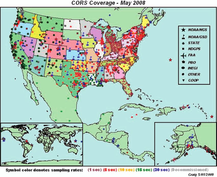
1990". In 1994, NGS officially began building the CORS network accurate positions economically and in a timely manner. Fig. 1
by installing a GPS receiver on the campus of the National Insti- shows the geographic distribution of CORS sites as of May
tutes of Standards and Technology, formerly called the National 2008. The primary access for CORS information is via the Web
Bureau of Standards, in Gaithersburg, Md. Six months later, NGS !#http://www.ngs.noaa.gov/CORS/$". See also the articles by Snay
installed a GPS receiver near Boulder, Colo. and with time incor- et al. !2002b" and Stone !2006".
porated into the CORS network a number of continuously oper- The CORS network continues to evolve as we speak. It is
ating GPS fiducial stations that originally were part of CIGNET. expected to increase by !200 stations in 2008 due to the large
Data from all these sites were made available via the Internet and, number of organizations establishing real-time positioning net-
progressively, NGS added selected U.S. permanent GPS base sta- works and the project to build EarthScope’s PBO for monitoring
tions to the CORS network. crustal motion. This rate of growth will result in a CORS network
The USCG and USACE began installing their DGPS sites and with average intersite distances on the order of 100 km in the
FAA their WAAS sites in 1995. NGS worked with these agencies contiguous United States. In light of this growth, NGS has re-
to incorporate both the DGPS and WAAS sites into the CORS cently updated its guidelines for establishing CORS sites !NGS
network. The initial phase of the USCG network was largely 2006", improved its tracking of metadata, upgraded its GPS
completed by January 1996, although more sites have since been analysis software !called PAGES", and is planning a complete
added. Other federal, state, and locally sponsored continuously reanalysis of all IGS plus CORS data observed since 1994. The
operating receivers were identified and gradually included into latter activity will be performed in collaboration with several
the CORS network from 1995 onwards. By 1995 NGS obtained other IGS Analysis Centers, and it is expected to be completed
access to more than 50 geodetic quality GPS receivers, most of within the year 2010.
them deployed by USCG and other participating agencies without
the need by NGS to install, maintain, or operate any of the sites. CORS and the Definition of the NSRS
The Texas Department of Transportation was the first state agency
to join the CORS system with the inclusion of their ten-station NGS derived the original realization of the North American
Regional Reference Point network that provided significant cov- Datum of 1983 !NAD 83" in 1986 by performing a rigorous ad-
96 / JOURNAL OF SURVEYING ENGINEERING © ASCE / NOVEMBER 2008Fig. 1. !Color" Operational CORS sites as of May 2008
justment of most of the classical geodetic observations in its ar- tonic plate. Similarly CORS sites located in Guam have been used
chives together with Doppler observations and a few very long to define the NAD83 !MARP00" reference frame for points
baseline interferometry !VLBI" baselines !Schwarz 1989". This located on the Mariana tectonic plate. More information about
original realization is called NAD 83 !1986". With improvements the procedures used to define these two reference frames is
in our knowledge of terrestrial reference frames, NGS has intro- available in Snay !2003". CORS sites have been also employed
duced several newer realizations of NAD 83, refining at each step to establish accurate geodetic control in other countries such as
the adopted coordinates. In 1998 NGS introduced the current re- Mexico !Soler and Hernández-Navarro 2006a" and Jamaica
alization, called NAD 83 !CORS96", which is based on the CORS !Newsome and Harvey 2003"
network by defining a transformation from the International Ter- When a CORS site first comes on line, NGS uses at least ten
restrial Reference Frame of 1996 !ITRF96" to NAD 83 !Craymer 24-h GPS data sets to compute this station’s ITRF2000 positional
et al. 2000". In both reference systems, ITRF and NAD 83 coordinates relative to other stations in the global IGS network.
!CORS96", the 3D positional coordinates of each CORS is Also, NGS uses the horizontal time-dependent positioning
complemented by a 3D velocity to account for crustal motion. A !HTDP" software !Snay 1999" to predict the station’s ITRF2000
more recent ITRF realization is known as the ITRF2000. velocity. NGS then transforms the ITRF2000 positional coordi-
ITRF2000 coordinates and velocities may be transformed to cor- nates and velocity for this CORS site into their corresponding
responding NAD 83 !CORS96" values using equations and pa- NAD 83 !CORS96" values via the adopted 14-parameter similar-
rameters described by Soler and Snay !2004". The NAD 83 ity transformation !Soler and Snay 2004".
!CORS96" positional coordinates are published for an epoch date Every few years, NGS reprocesses all CORS data collected
of 2002.0, except in Alaska and California where epoch dates of since 1994 to compute provisional positions and velocities for all
2003.0 and 2004.0, respectively, have been adopted because of CORS relative to the current ITRF realization: call it ITRFxx. If,
recent earthquakes. One must apply the adopted velocities to for any station, these provisional ITRFxx positional coordinates
compute positional coordinates for any other epoch date. At this differ from the currently adopted ITRFxx positional coordinates
writing, the coordinates and velocities of the CORS sites form the by more than 1 cm in the north-south or east-west component or
foundation of the NSRS and the recently completed NAD 83 by more than 2 cm in the vertical component, then NGS adopts
!NSRS2007" readjustment !Vorhauer 2007". the provisional position and velocity to supersede the previously
It is important to note that CORS sites located in Hawaii and adopted ITRFxx position and velocity.
other Pacific islands have been used to define the NAD 83 In addition to this validation process, NGS performs a solution
!PACP00" reference frame for points located on the Pacific tec- for each day to monitor the quality of adopted CORS positional
JOURNAL OF SURVEYING ENGINEERING © ASCE / NOVEMBER 2008 / 97coordinates. Each solution includes all CORS data collected dur- cessed at this time, although in the future they will be accepted
ing the 24-h period spanning that day. As a by-product, NGS along with Galileo data, as the constellation of this European
compiles plots showing differences between the published navigational system becomes available. Strictly based on Internet
ITRF2000 coordinates and the values obtained from the daily access, OPUS provides the geospatial community with position-
solutions, corrected for crustal motion, for the latest 60 days. The ing referred to both the ITRF2000 and the NAD 83 !CORS96"
results are plotted relative to a local horizon !north-east-up" coor- reference frames. OPUS routinely achieves accuracies !reported
dinate frame and are made available to the general public through as “peak-to-peak” values" better than 2 cm in the horizontal
the CORS Web page !ftp://www.ngs.noaa.gov/cors/Plots/ dimensions and 5 cm in the vertical dimension by using corre-
xxxx.pdf; where xxxx denotes the site’s four-character identifica- sponding data from three nearby CORS sites. Readers interested
tion". The movement or replacement of the antenna or an in knowing the statistical meaning of the peak-to-peak values
unexpected natural phenomenon may displace the position of the reported by OPUS should read Schwarz !2006". More detailed
CORS reference point. Geophysical processes !earthquakes, vol- information about OPUS may be obtained in a number of refer-
canic activity, etc." may also produce significant station displace- ences, e.g., Mader et al. !2003"; Stone !2006"; Soler et al.
ments that should be documented. This information is critical to !2006c"; and Weston et al. !2007". The infrastructure of OPUS is
CORS users if they want to use CORS data to determine accurate the GPS data and the fiducial control available from the CORS
positional coordinates for points of interest to them. When the sites. The original idea of creating CORS to support GPS survey-
trend of the 60-day series of daily estimates differ from this sta- ing activities reached a new level of efficiency with the introduc-
tion’s adopted positional coordinates by more than the tolerances tion of OPUS. The geodetic, surveying, mapping, and GIS
described in the preceding paragraph !1 cm horizontal; 2 cm communities have embraced OPUS with great enthusiasm. The
vertical", then NGS carefully analyzes the available data to de- progress of this Internet-based utility has been nothing less than
termine whether or not this station’s published positional coordi- spectacular since its inception in 2001. Fig. 2 depicts OPUS usage
nates and velocities should be updated. Similar analysis is done by county during the 12-month period from May 2007 to April
with respect to the adopted NAD 83 !CORS96" coordinates. 2008. As Fig. 2 shows, during this period a total of 171,573
When the daily provisional transformed coordinates referred to OPUS solutions were successfully processed. For completeness, it
the NAD 83 frame differ by more than 2 cm in the north-south or should be reported that during the same 1-year period OPUS pro-
east-west component or by more than 4 cm in the vertical com- cessed a total of 23,502 data sets observed outside the United
ponent, then NGS adopts the provisional NAD 83 positional co- States. The number of OPUS users is expected to increase signifi-
ordinates and velocity to supersede the previously adopted NAD cantly now that NGS is broadening the functionality of OPUS. On
83 values. As a result of these less stringent tolerances, adopted January 31, 2007, the first variation of OPUS, called OPUS-RS
NAD 83 !CORS96" positional coordinates and velocities are less !rapid static", was declared “initially” operational. Like the origi-
likely to be updated than their ITRF counterparts. However, this nal implementation of OPUS, OPUS-RS computes positions in
NGS policy, established in 1999 is currently being discussed at differential mode for dual-frequency data collected by a GPS re-
NGS for possible revision to lower tolerances in response to both ceiver. What’s new about OPUS-RS is a new processing engine
internal and external requests. !Schwarz 2008", allowing as little as 15 min of data, while !gen-
For those agencies whose sites are included in the CORS erally" maintaining the accuracy of the original OPUS. The user
network, NGS computes highly accurate 3D positional coordi- can send GPS data to OPUS-RS by accessing: http://
nates and velocities in the NSRS for their site antennas, provides www.ngs.noaa.gov/OPUS/. For a brief introduction to OPUS-RS,
an international data distribution mechanism, monitors the posi- see Martin !2007"; Meade !2007". A practical example of how
tions of the antennas on a daily basis, and notifies the agencies OPUS-RS can be applied to day-to-day work in surveying engi-
when movements of the antennas are detected. In exchange, the neering is described in Lazio !2007". Another variation of OPUS
agencies notify NGS when they change equipment or software will be OPUS-DB !database" that will require a minimum of 4 h
so that NGS can keep CORS users abreast of the status of the of observations but will give surveyors, geodetic engineers, and
CORS sites. Scientific users who monitor very small move- others the option of archiving the resulting positional coordinates
ments of the Earth’s crust are especially interested in any antenna in an NGS database for public accessibility. Finally, OPUS-
changes so that they can account for those effects when they Mapper is being developed to process L1 code data to determine
undertake long-term analyses of site locations. When antenna positional coordinates accurate enough for mapping and GIS ap-
changes are detected and corrections made, NGS immediately plications. Although each of these functionalities are being devel-
publicizes this information through the CORS Newsletter !http:// oped in phases, they will ultimately all be part of an integrated
www.ngs.noaa.gov/CORS/newsletter1/". “OPUS” utility.
In March 2001, efficient access to the NSRS through GPS was
introduced with the release of the On-line Positioning User Ser-
vice !OPUS" utility. OPUS is an automatic service that requires Data Archives
the user to input only a minimal amount of information; its in-
structions are self-explanatory and its Web page contains enough All CORS data are collected at two facilities, one located in
details to be followed easily !http://www.ngs.noaa.gov/OPUS/". Silver Spring, Md. and the other in Boulder, Colo. At each facil-
However, OPUS has a few restrictions users should be aware of: ity, the GPS data are organized into various types of formatted
first, and most importantly, OPUS provides a differential GPS files !RINEX, Hatanaka, etc." for public distribution. People may
static solution. Second, a minimum of 2 h of GPS observations freely access these data files and related metadata either via
are recommended to obtain surveying-geodetic accuracies !Soler anonymous file transfer protocol !ftp://www.ngs.noaa.gov/cors/"
et al. 2006b". Third, a maximum of 48 h of GPS data is permitted or via the World Wide Web !http://www.ngs.noaa.gov/CORS/". In
!the GPS data can cross midnight only once". Fourth, the submit- January 2000, NGS introduced a new interface to the CORS web
ted data file must contain dual-frequency !L1/L2" carrier phase site. This new interface is known as CORSAGE !CORS Amiable
observables. Finally, GLONASS observations cannot be pro- Geographic Environment" because it enables people to access
98 / JOURNAL OF SURVEYING ENGINEERING © ASCE / NOVEMBER 2008Fig. 2. !Color" OPUS usage by county from May 2007 to April 2008
CORS data and metadata through a series of geographic maps. standard CORS information server provide the information only
The CORS homepage itself features an index map in which the in the format that is stored at NGS, whereas UFCORS can re-
total area of CORS coverage has been partitioned into several package the information into any of several different formats. For
color-coded regions, each usually involving a few states. On a example, with UFCORS a person can download GPS data files
regional map, a user can click his/her mouse on the map symbol for any discretionary number of hours "!24#. Also UFCORS al-
representing a particular CORS site to obtain a window contain- lows users to select how the requested data files should be com-
ing a local map that pinpoints this site’s location relative to pressed. UFCORS also can interpolate GPS data to sampling
nearby population centers, major roads, and other geographic fea- rates, other than the standard 30-s rate. Finally, UFCORS can
tures. A menu appears to the left of the local map which enables
decimate archived CORS data of one sampling rate to a user
users to view/download particular information about this site, for
specified sampling rate of greater value.
example, a file containing the site’s positional coordinates and
velocity. Another item on this menu enables users to view a cal- Anonymous FTP remains the most popular CORS information
endar displaying—with 10-min resolution—the time span when server in terms of data volume. More than 581 gigabytes of
CORS data are available for this site. Inspecting such calendars CORS data were distributed via anonymous FTP in April 2008
can save users from downloading and processing files that contain %Fig. 3!a"&, whereas UFCORS distributed about 66 Gbytes in
undesirable data gaps. Other menu items provide access to the April 2008 %Fig. 3!b"&. Anonymous FTP is the server of choice
site’s GPS data and to files containing certain descriptive infor- among users that download GPS data from many CORS sites on
mation about this site !type of GPS equipment, responsible insti- a regular basis. Users who download CORS data only occasion-
tution, contact person, history of receiver and antenna ally or only from a few stations prefer to use UFCORS.
replacements, etc." Access to CORS information using a geo-
graphic Google interface has recently been added.
CORS Applications
UFCORS In addition to the primary application of CORS, to enable accu-
rate positioning relative to the NSRS, CORS has been pivotal in
In November 1998, NGS introduced the “user-friendly” CORS
advancing other, well documented, multidisciplinary investiga-
!UFCORS" information server that enables users to request and
receive GPS data and associated metadata !satellite ephemeris tions. The scientific literature is flooded with articles citing CORS
and station-specific descriptive information" for stations in the as the basis for their experiments and/or research projects. The
CORS network via the World Wide Web. UFCORS provides a realm of applications is diverse and multifaceted and it is ex-
convenient alternative to both the anonymous FTP information pected that this trend will continue in the future. CORS has al-
server and the Web-based “standard” CORS information server ready made an impact on solid Earth science and is on the fringe
for retrieving CORS information. UFCORS allows a user to se- of significantly impacting atmospheric science. In the following
lect a comprehensive package of information for a particular sta- sections, we describe a few areas where the use of CORS data
tion and a particular time interval. Anonymous FTP and the was significant in advancing scientific knowledge.
JOURNAL OF SURVEYING ENGINEERING © ASCE / NOVEMBER 2008 / 99FTP CORS Monthly Gigabytes Downloaded 8-h sessions, 40 nonoverlapping 6-h sessions and, finally, 60
nonoverlapping 4-h sessions. The results of this investigation
900 empirically demonstrated that the dependence of accuracy on
839
831
795
baseline length is negligibly small, whereas the dependence on
769
800
742
724
707
the duration time of the observing session obeys the following
690
689
686
682
681
678
671
Number of Gigabytes
700
625
616
simple mnemonic rule when the observing time spans 4 h or
609
604
599
581
576
573
570
567
561
600
longer:
522
499
494
494
486
485
484
477
472
% &
500
446
446
442
429
405
403
401
396
396
378
376
366
363
355
400
325 k k = 1.0 horizontal "north and east#
323
295
293
287
"1#
276
266
RMSE =
260
$T
251
300
k = 3.7 vertical "up#
200
100 In Eq. !1", the root mean square error !RMSE" is given in centi-
0 meters when T denotes the duration of the observation session in
hours and k is a constant "cm$h#. Soler et al. !2006b" reached
Aug-03
Aug-04
Aug-05
Aug-06
Aug-07
Apr-04
Apr-05
Apr-06
Apr-07
Dec-03
Dec-04
Dec-05
Dec-06
Dec-07
Apr-08
(a) similar conclusions for data sets having durations of 2, 3, and 4 h.
Experiments involving 1-h data sets suffered from an inability to
UFCORS Monthly Gigabytes Downloaded reliably determine the integer values of the carrier phase ambigu-
ities caused by the nonaveraging atmospheric conditions at the
120
control stations. Preliminary results, however, demonstrate that
110
109
OPUS-RS can produce accurate positional coordinates for observ-
103
ing sessions as short as 15 min in duration by interpolating atmo-
97
97
100
96
95
Number of Gigabytes
91
spheric conditions measured at CORS sites to the location where
86
82
81
80
80 the OPUS-RS user collected his/her GPS data.
75
71
70
68
67
67
66
66
65
62
59
57
60
55
52
51
51
50
50
Multipath Studies
41
41
40
39
39
38
38
38
38
37
40
34
33
32
32
30
30
29
29
For GPS antennas, multipath errors are caused by the interference
28
27
27
26
26
26
25
24
23
22
19
18
18
20 of signals that have reached the receiver antenna by two or more
16
different paths, usually caused by one path being bounced or re-
0
flected from the ground or nearby surfaces !buildings, fences,
July-04
Nov-03
Nov-04
Nov-05
Nov-06
Nov-07
Mar-03
Jul-03
Mar-08
Mar-05
Jul-05
Mar-06
Jul-06
Mar-07
Jul-07
Mar-08
etc.". The understanding of multipath effects is important to deci-
(b)
pher the systematic errors associated with a particular station and
antenna and the possibility to correct for them. Hilla and Cline
Fig. 3. Monthly volumes of CORS data downloaded !a" using FTP;
!b" using UFCORS
!2004" conducted an investigation to evaluate the amount of mul-
tipath occurring at each of 390+ sites contained in the National
CORS network. This study identified the most and least affected
sites in the network, compared different receiver/antenna combi-
Upgrading the NSRS
nations, and investigated closely those sites that appeared to be
NGS recently completed an adjustment involving GPS data ob- severely affected by multipath. Dual-frequency carrier phase and
served at !70,000 geodetic marks during the past 20 years. This pseudorange measurements were used to estimate the amount of
adjustment termed NAD 83 !NSRS2007" held fixed the published L1 and L2 pseudorange multipath at each site over a one-year
NAD 83 !CORS96" 3D positional coordinates of the CORS sites, period. A similar study !Park et al. 2004" combining CORS and
to obtain a solution whose coordinates are consistent with the IGS sites also found that the postfit phase residuals were highly
NAD 83 !CORS96" frame. Once more, the CORS network fulfills dependent on the GPS antenna type. This investigation concluded
its primary mission of implementing the NSRS. Thus, because of that antenna types with choke rings are very effective in suppress-
the procedure followed !Vorhauer 2007" these !70,000 geodetic ing multipath and that multipath is highly dependent on the
marks now have positional coordinates that are compatible with unique environment at each site.
the NAD 83 !CORS96" reference frame.
Crustal Motion
Assessing GPS Observational Accuracies
Crustal motion monitoring is perhaps one of the most obvious of
The availability of continuous GPS data from stations well dis- all CORS applications. If CORS data are rigorously processed
tributed throughout the United States makes it possible to design and analyzed during a period of several years, then the motion of
experiments aimed to answer many questions related to GPS the Earth’s crust can be determined wherever the CORS network
methodologies now in vogue and to expand our understanding of provides sufficient coverage.
scientific phenomena. Eckl et al. !2001" and Snay et al. !2002a" Gan and Prescott !2001" analyzed GPS data observed between
studied the accuracy of GPS-derived relative positions as a func- 1996 and 2000 for 62 CORS sites distributed throughout the cen-
tion of interstation distance and observing-session duration using tral and eastern United States. Their results suggest that no sig-
data from 19 CORS sites. Eleven baselines connecting pairs of nificant horizontal crustal motion occurred during this time period
these 19 sites were formed with lengths ranging from 26 to in this part of the country, except possibly in the lower Missis-
300 km. GPS data for each baseline was partitioned into 10 sippi River Valley. This particular area appears to be moving
nonoverlapping 24-h sessions. These same data were also sub- southward relative to the rest of the continent at an average rate of
divided into 20 nonoverlapping 12-h sessions, 30 nonoverlapping 1.7" 0.9 mm/ year. Although this rate is not statistically signifi-
100 / JOURNAL OF SURVEYING ENGINEERING © ASCE / NOVEMBER 2008cant at the 95% confidence level, the fact that the motion occurs effectively separated with little error. Mapping the resulting wet
near New Madrid, Mo.—where earthquake risk is thought to be signal delay into the integrated !total column" precipitable water
high—argues that the motion may be real. vapor !IPW" is accomplished in a straightforward manner if the
Sella et al. !2002" applied GPS data from the CORS network, mean vapor-weighted temperature of the atmosphere is known.
together with data from a worldwide distribution of stations, to Water vapor is one of the most important constituents of the
produce a global “recent velocity” !REVEL" model that quantifies Earth’s atmosphere. It is the source of clouds and precipitation,
the motions of 19 tectonic plates and continental blocks during and an ingredient in most major weather events. IPW varies
the 1993–2000 time interval. greatly over the planet: #5 mm near the poles and $50 mm near
Park et al. !2002" used data from 60 CORS sites to estimate the equator. Most "!95% # of the water in the atmosphere resides
the upper and lower mantle viscosity by comparing radial site below 5 km !or essentially below the 500 hPa pressure surface".
velocities with velocities inferred from glacial isostatic adjust- Significant changes in the vertical and horizontal distribution of
ment !GIA" models. In addition, their GPS-derived velocities are water vapor can occur rapidly !minutes to hours" during active
consistent with previous estimates obtained using different meth- weather.
ods and data over different time spans. NOAA’s Earth Systems Research Laboratory !ESRL", for-
Recently, the deformation occurring within the North Ameri- merly called NOAA’s Forecast Systems Laboratory, has devel-
can plate interior was estimated using 10 years of GPS data from oped the capability to estimate the spatial and temporal variation
the CORS network processed using both the GIPSY and GAMIT of tropospheric delay within the contiguous United States
software packages !Calais et al. 2006". These authors analyzed !CONUS" !Gutman et al. 2004". Their prediction process is based
data from about 300 CORS stations covering the central and east- on modeling the delay using GPS observations from the CORS
ern United States. The investigation indicates that the velocity network in combination with other meteorological data. They up-
field is described within uncertainties by a simple rigid plate ro- date their model every hour. It is possible to use CORS sites to
tation that is distorted in some areas by a deformation pattern estimate the tropospheric signal delay at each station with high
consistent with GIA. Similarly, using CORS sites and episodic accuracy because of stringent instrument requirements for high
GPS data in Canada and the United States, Sella et al. !2007" accuracy GPS positioning. Data from a network of approximately
show that the strongest signal within the nominally stable interior 385 CORS sites are assimilated hourly into the operational ver-
of the North American plate is the effect of GIA due to mass sion of the rapid update cycle !RUC" numerical weather predic-
unloading during deglaciation. On a more local scale, Dokka et al. tion model which refers the results to a two-dimensional !2D"
!2006" used GPS data from CORS sites to infer that southeast horizontal grid having a 13-km nodal spacing.
Louisiana, including New Orleans and the larger Mississippi The Global Systems Division of NOAA’s ESRL has developed
Delta, are both subsiding vertically and moving southward with NOAATrop, a new way to improve GPS positioning, navigation
respect to the interior of the North American plate. and timing accuracy using real-time weather data at CORS sites
!Gutman et al. 2004". NOAATrop is available for download at
ftp://aftp.fsl.noaa.gov/gpsmet/zwdgrids/. This information pro-
Sea Level Changes
vides zenith wet delay and ALT !a proxy for zenith hydrostatic
The variations of vertical crustal velocities at CORS sites near delay" for a 2D grid with 13-km resolution over the CONUS.
tide gauge stations may be used to determine the “absolute” sea NOAATrop is based on RUC, an operational model that is up-
level change with respect to the International Terrestrial Refer- dated hourly. The root mean square accuracy of the modeled de-
ence Frame. This type of analysis was impossible to conduct be- lays is currently !2 cm in cold seasons and #4 cm in warm
fore the proliferation of CORS in coastal areas. Recently, a study seasons.
by Snay et al. !2007" involving 37 tide gauge stations, distributed
along the U.S. and Canadian coasts, such that each is located
Ionospheric Studies
within 40 km of a CORS site, determined rigorously the crustal
velocity near tide gauge stations from GPS observations spanning Wide area ionospheric models have been developed to model and
between 3 and 11 years. After calibrating historical tidal data with mitigate local ionospheric effects. Such models are based on dual
these derived crustal velocities, the results show that the mean frequency observations from a subset of the CORS network.
rate of absolute sea level change equals 1.80" 0.18 mm/ year for The ionosphere is a dispersive medium located in the region of
the 1900–1999 interval. The same investigation determined the the upper atmosphere that begins at an altitude of around 50 km
absolute rate of sea level change equals −1.19" 0.70 mm/ year and extends upwards several hundred kilometers. The radiation
along the southern Alaskan coastline. This lowering of absolute from the Sun and particles precipitating from the magnetosphere
sea level near southern Alaska is probably due to ongoing melting produces free electrons and ions that cause phase advances and
of mountain glaciers and ice masses. With time, more CORS data group delays in radio waves. The state of the ionosphere is a
will become available near tide gauges to conduct investigations function of the intensity of solar and magnetic activity, position
able to accurately estimate vertical crustal velocities and thereby on the Earth, local time and other factors. As GPS signals traverse
absolute sea level rates with greater certainty. the ionosphere, they are delayed by an amount proportional to the
total electron content !TEC" within the ionosphere at a given
time. Daily maps showing the estimation of TEC over the
Tropospheric Studies
CONUS based on CORS data from about 180 stations have been
The delay of GPS signals, which is caused by the refractivity of produced at NGS and distributed through the Internet since 1997
the troposphere or electrically neutral atmosphere, is associated !Musman et al. 1997".
with temperature, pressure, and the distribution of water vapor Recently NOAA’s Space Weather Prediction Center !SWPC"
up to a height of about 16 km. If the atmospheric pressure is began modeling TEC in 3D for CONUS using CORS data
known with reasonable accuracy at the elevation of the GPS an- !Fuller-Rowell et al. 2006". This model is updated every 15 min
tenna, then the total “wet” and “dry” delay at the site can be with a latency of 30 min !http://www.sec.noaa.ustec/index.html".
JOURNAL OF SURVEYING ENGINEERING © ASCE / NOVEMBER 2008 / 101This product is designed to quantify TEC over CONUS in near tide gauge stations contained in the U.S. National Water Level
real time and has evolved through collaboration between the Observation Network !NWLON". Established in 1913, the Key
SWPC, NGS, ESRL, and NOAA’s National Geophysical Data West tide gauge station is one of the longest continually opera-
Center. tional stations contained in the NWLON.
Data from the CORS network have been used in studies of The new CORS at Key West is also significant because it
large-scale ionospheric disturbances caused by geomagnetic is the first CORS, installed by NGS, which collects both GPS
storms on a continental scale !Tsugawa et al. 2003". Investiga- and GLONASS data. A number of CORS partners have begun
tions to correct for ionospheric effects in local CORS networks upgrading stations to collect both GPS and GLONASS data,
!e.g., Ohio State" established for real-time kinematics !RTK" and NGS will soon begin distributing such GNSS data to CORS
applications have proliferated lately with the deployment of state- users.
operated CORS networks !Wielgoz et al. 2005a,b; Grejner- Additionally, several CORS are streaming GPS data in real
Brzezinska et al. 2007". GPS data from CORS sites have been time to NGS headquarters in Silver Spring, Md. NGS will broad-
used to test ionospheric models aimed to improve long baseline cast these data to the public in real time to support the growth of
differential GPS positioning of rovers using only L1 data !Mo- regional GNSS networks that enable real-time positioning in the
hino et al. 2007". Finally, Smith !2004" experimentally introduced United States. In response to user demands, more than 40 orga-
an interesting alternative approach to compute absolute !unam- nizations, both public and private, are now establishing such re-
biguous" TEC values relying only on dual frequency ambiguous gional GNSS networks. Also, many more of these regional real-
carrier phase data from the CORS network, though the approach time positioning networks are expected to be established in the
was only a research prototype. near future. NGS needs to support these networks by developing
appropriate standards and guidelines so that:
• Promulgated positional coordinates and velocities for the cor-
Geolocation of Aerial Moving Platforms
responding GNSS base stations are compatible with the
Data available from CORS sites has been used in many remote NSRS;
sensing applications. The accurate positioning of aircrafts em- • User equipment can operate with services from different real-
ployed in aerial mapping is crucial to improve the reliability of time GNSS networks to the greatest extent possible; and
photogrammetric restitution primarily for large-scale aerial survey • Stations contained in each real-time network meet prescribed
applications over remote or inaccessible terrain. The same con- criteria in terms of stability and data quality.
cepts implemented for geolocating landmarks from the air with Accordingly, NGS is considering the possibility of streaming
digital cameras has been extended to a broad array of mapping GNSS data from about 200 federally funded CORS so that this
terrain applications using cutting edge technologies such as agency may understand the intricacies involved in operating a
scanning radar, light detection and ranging !LiDAR", inertial sys- real-time GNSS network to the extent necessary to develop ap-
tems, interferometric synthetic aperture radar, and/or sonar. The propriate standards and guidelines.
use of CORS data in airborne mapping processes has proven to NGS encourages the institutions, who are providing real-time
provide a significant alternative !Mostafa 2005". The utility of positioning services, to use the NGS-provided data in their opera-
CORS sites in differential GPS aircraft positioning was investi- tions so as to !1" supplement the data from other GNSS base
gated by Booth and Lunde !2003" showing that very accurate stations, and !2" use the positional coordinates and velocities of
carrier phase differential results can be obtained using much the GNSS stations contained in the NGS real-time network as
longer baselines than originally thought. The aerial mapping com- fiducial values for determining positional coordinates and veloci-
munity will certainly benefit from the growing number of CORS ties of other real-time GNSS stations.
sites. Perhaps, the decisive factor in all these applications is the Also, NGS is planning to stream these data because U.S. citi-
accessibility to GPS data at a 1-s sampling rate instead of the zens should have real-time access to data from federally funded
standard of 30-s sampling rate. NGS has cooperated with federal, stations in the CORS network whenever it is economically and
state, and private institutions to schedule ahead of time changes at technically feasible to do so. It is important to emphasize that
specified CORS sites to the 1-s sampling rate. This facilitates the NGS intends to stream only the GNSS observables and not “cor-
postprocessing of airborne GPS data to accurately estimate the rectors” to these observables. Also, NGS does not intend to
position of a plethora of aerial moving platforms. For example, stream GNSS data that are already being streamed by another
NGS’s Remote Sensing Division obtains aerial imagery to assess organization. In all likelihood, NGS will use NTRIP !networked
hurricane damage. These missions are well served by CORS data, transport of RTCM standard via internet protocol" to broadcast
collected at a 1-s sampling rate, to accurately determine the travel the stream of GNSS observables over the Internet.
path of the aircraft being used to collect aerial imagery. NGS
personnel worked closely with their CORS partners to tempo-
rarily increase data sampling rates after the hurricanes of 2005. Conclusions
The imagery of areas affected by individual hurricanes is avail-
able at www.ngs.noaa.gov. The intent of this paper was to summarize the history, applica-
tions, and future prospects of the CORS network by describing
the more important contributions of the CORS system to the sci-
On the CORS Horizon entific community. Many surveying engineers, geodesists, map-
ping specialists, as well as scientists from different backgrounds,
In December 2006, NGS installed a new CORS near the tide are using CORS on a daily basis by downloading GPS data
gauge station located in Key West, Fla. This CORS will help through UFCORS and anonymous FTP, and then postprocessing
relate local sea level change at Key West to the globally consis- these data for a variety of applications. The CORS network has
tent, rigorously defined International Terrestrial Reference Frame. contributed significantly to geodetic positioning by providing
Indeed, NGS plans to install a CORS at each of several additional easy and accurate access to the NSRS. The CORS network should
102 / JOURNAL OF SURVEYING ENGINEERING © ASCE / NOVEMBER 2008also be recognized for supporting the research of numerous sci- Greenfeld, J., and Sens, J. D. !2003". “Determination of orthometric
entific investigators. Finally, the CORS network serves as the height of NJI2 CORS station.” J. Surv. Eng., 129!3", 110–114.
primary data source for all types of OPUS solutions. Grejner-Brzezinska, D. A., Kashani, I., Wielgoz, P., Smith, D. A.,
Spencer, P. S. J., Robertson, D. S., and Mader, G. L. !2007". “On
efficiency and reliability of ambiguity resolution in network-based
RTK GPS.” J. Surv. Eng., 133!2", 56–65.
Acknowledgments Gutman, S. I., Sahm, S. R., Benjamin, S. G., Schwartz, B. E., Holub,
K. L., Stewart, J. Q., and Smith, T. L. !2004". “Rapid retrieval and
This paper is dedicated to Bill Strange, the “Father of CORS.” assimilation of ground based GPS precipitable water observations at
Bill’s vision and impetus when he served as NGS’s Chief Geod- the NOAA Forecast Systems Laboratory: Impact on weather fore-
esist provided the inspiration that shaped the early days of the cast.” J. Meteorol. Soc. Jpn., 82!1B", 351–360.
Hilla, S., and Cline, M. !2004". “Evaluating pseudorange multipath ef-
CORS program. Although initially designed to support geodetic
fects at stations in the National CORS network.” GPS Solutions, 7!4",
activities, the CORS program has contributed to several addi- 253–267.
tional scientific applications. Other important contributors from Lazio, P. !2007". “Constraining network adjustments to OPUS-RS coor-
NGS include, in alphabetical order: Gordon Adams, Donna Amo- dinate observations.” J. Surv. Eng., 133!3", 106–113.
roso, Nancy Brantner, Hong Chen, Miranda Chin, Michael Cline, Mader, G. L., Weston, N. D., Morrison, M. L., and Milbert, D. G. !2003".
Cindy Craig, Dave Crump, William Dillinger, Dave Doyle, Nancy “The on-line positioning user service !OPUS".” Profess. Surv., 23!5",
Doyle, Jim Drosdak, Robert Dulaney, Mark Eckl, Joseph Evjen, 26–30.
Richard Foote, Steve Frakes, Don Haw, Steve Hilla, Michelle Ho, Martin, D. !2007". “Geodetic connections—OPUS rapid static.” The
Toni Hollingsworth, Ying Jin, William Kass, Gerald Mader, Ri- American Surveyor, 4!3", 44–48.
chard Male, Ernie Marion, Frank Mowry, Linda Nussear, Julie Meade, M. E. !2007". “OPUS rapid static.” Point of Beginning, 32!8",
60–63.
Prusky, Jim Ray, Jim Rohde, Bruce Sailer, Donna Sailer, Mark
Mohino, E., Gende, M., and Brunini, C. !2007". “Improving long baseline
Schenewerk, Charles Schwarz, Giovanni Sella, Dru Smith, Paul "100– 300 km# differential GPS positioning applying ionospheric cor-
Spofford, Lijuan Sun, Vicki Veilleux, and Neil Weston. Their con- rections derived from multiple reference stations.” J. Surv. Eng.,
tinuous striving for perfection has been exemplary. Finally, the 133!1", 1–5.
success of the CORS program is due to contributions from more Mostafa, M. M. R. !2005". “Precise airborne GPS positioning alternatives
than 200 organizations, with each organization operating at least for the aerial mapping practice.” Proc., FIG Working Week 2005,
one CORS. For a current list of these organizations, please see the Fédération Internationale des Géometrès !FIG", Frederiksberg, Den-
CORS Newsletter at www.ngs.noaa.gov/CORS/. Comments on mark, 1–9.
the draft made by John Hamilton and two anonymous reviewers Musman, S., Mader, G., and Dutton, C. E. !1997". “Total electron content
are greatly appreciated. changes in the ionosphere during the January 10, 1997 disturbance.”
Geophys. Res. Lett., 25!15", 3055–3058.
National Geodetic Survey !NGS". !2006". “Guidelines for new and exist-
ing continuous operating reference stations !CORS".” #http://
References www.noaa.gov/PUBS_LIB/CORS_guidelines.pdf$ !May 10, 2007".
Newsome, G. G., and Harvey, B. R. !2003". “GPS coordinate transfor-
Booth, J., and Lunde, T. !2003". “Carrier-phase DGPS system accuracy mation parameters for Jamaica.” Surv. Rev., 37!289", 218–234.
tests: Increasing baseline distance and using CORS network data.” Park, K.-D., Nerem, R. S., Davis, J. L., Schenewerk, M. S., Milne, G. A.,
Proc., ION GPS/GNSS 2003, Institute of Navigation !ION", Fairfax, and Mitrovica, J. X. !2002". “Investigation of glacial isostatic adjust-
Va., 889–896. ment in the northeast U.S. using GPS measurements.” Geophys. Res.
Calais, E., Han, J. Y., DeMets, C., and Nocquet, J. M. !2006". “Deforma- Lett., 29!11", 1–4.
tion of the North American plate interior from a decade of continuous Park, K. D., Nerem, R. S., Schenewerk, M. S., and Davis, J. L. !2004".
GPS measurements.” J. Geophys. Res., 111!B06402", 1–23. “Site-specific multipath characteristics of global IGS and CORS GPS
Chin, M. M., Crump, D. R., and Berstis, K. A. !1987". “The status of the sites.” J. Geodesy, Berlin, 77!12", 799–803.
NGS GPS orbit tracking network !abstract".” EOS Trans. Am. Geo- Ray, J., Crump, D., and Chin, M. !2007". “New global positioning system
phys. Union, 68!44", 1239–1239. reference station in Brazil.” GPS Solutions, 11!1", 1–10.
Craymer, M., Ferland, R., and Snay, R. !2000". “Realization and unifica- Schenewerk, M. S., Mader, G. L., Chin, M., Kass, W., Dulaney, R.,
tion of the NAD 83 in Canada and the U.S. via the ITRF.” Towards an MacKay, J. R., and Foote, R. H. !1990". “Status of CIGNET and orbit
integrated global geodetic observing system (IGGOS), R. Rummel, H. determination at the National Geodetic Survey.” Proc., 2nd Int. Symp.
Drewes, W. Bosch, and H. Hornik, eds., International Association of on Precise Positioning with the Global Positioning System. Ottawa,
Geodesy Symposia, Vol. 120, Springer, Berlin, 118–121. 179–189.
Dokka, R. K., Sella, G. F., and Dixon, T. H. !2006". “Tectonic control of Schutz, B. E., Ho, C. S., Abusali, P. A. M., and Tapley, B. D. !1990".
subsidence and southward displacement of southeast Louisiana with “Casa Uno GPS orbit and baseline experiments.” Geophys. Res. Lett.,
respect to stable North America.” Geophys. Res. Lett., 33!L23308", 17!5", 643–646.
1–5. Schwarz, C. R., ed. !1989". “North American Datum of 1983.” NOAA
Eckl, M. C., Snay, R., Soler, T., Cline, M. W., and Mader, G. L. !2001". Professional Paper NOS2, National Geodetic Survey, Rockville, Md.
“Accuracy of GPS-derived relative positions as a function of intersta- Schwarz, C. R. !2006". “Statistics of range of a set of normally distrib-
tion distance and observing-session duration.” J. Geodesy, Berlin, uted numbers.” J. Surv. Eng., 132!4", 155–159.
75!12", 633–640. Schwarz, C. R. !2008". “Heuristic weighting and data conditioning in the
Fuller-Rowell, T., Araujo-Pradere, E., Minter, C., Codrescu, M., Spencer, National Geodetic Survey Rapid Static GPS !RSGPS" software.” J.
P., Robertson, D., and Jacobson, A. R. !2006". “US-TEC: A new data Surv. Eng., 134!3", 70–75.
assimilation product from the Space Environment Center characteriz- Sella, G. F., Dixon, T. H., and Mao, A. !2002". “REVEL: A model for
ing the ionospheric total electron content using real-time GPS data.” recent plate velocities from space geodesy.” J. Geophys. Res.,
Radio Sci., 41!RS6003", 1–8. 107!ETG11", 1–30.
Gan, W., and Prescott, W. H. !2001". “Crustal deformation rates in central Sella, G. F., Stein, S., Dixon, T. H., Craymer, M., James, T. H., Mazzotti,
and eastern U.S. inferred from GPS.” Geophys. Res. Lett., 28!19", H., and Dokka, R. K. !2007". “Observation of glacial isostatic adjust-
3733–3736. ment in '' stable (( North America with GPS.” Geophys. Res. Lett.,
JOURNAL OF SURVEYING ENGINEERING © ASCE / NOVEMBER 2008 / 103You can also read