Cretan Gas Fields - A new perspective for Greece's hydrocarbon resources - www.pytheas.net
←
→
Page content transcription
If your browser does not render page correctly, please read the page content below
Pytheas
Market
Focus

                                    March 2012

 Cretan Gas Fields – A new perspective for
          Greece’s hydrocarbon resources

                                     Alain Bruneton
                                     Elias Konofagos
                                   Anthony E. Foscolos

          www.pytheas.net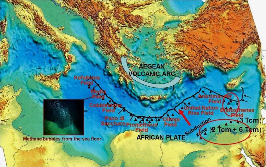
Pytheas
Market
Focus

            Note
            The original title for this Paper first published in the Greek language was “The occurrence
            of converging plates, mud flow volcanoes and accretionary prism complexes in the
            Mediterranean Ridge. Their relationship to possible hydrocarbon accumulations offshore
            Crete. A new perspective for Greece’s oil and natural gas resources”.

            Acknowledgement
            The Authors wish to thank Mrs. Rachel Robinson of the Geological Survey of Canada,
            Calgary for her help with the English editing of this paper.

          Copyright © 2012 Pytheas Limited           30 March 2012                                        2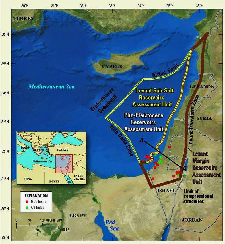
Pytheas
Market
Focus

          Forward

                             The Greek island of Crete, located in the South-Eastern Mediterranean, about,
                             300 km north of the African continent, 500 km from the newly discovered gas
                             fields of Cyprus and 800 km from the gas fields of Israel, west of the Middle
                             East and Asian continent, and 600 km east of mainland Europe but 90 km from
                             mainland Greece, is not only in one of Europe’s main energy corridors but valid
                             scientific research indicates that significant oil and gas deposits must more
           H. A. Samaras     than likely occur offshore the island.

          It is no coincidence that eight of the world’s biggest seismic survey companies (i.e., U.S.-
          based ION Geophysical, Norway-based TGS-NOPEC, Dolphin Geophysical and Petroleum Geo-
          Services, France’s CGGVeritas, Spec Partners, Spectrum Geo and Fugro Multi Client Services)
          have expressed interest earlier this month in investing about US$40 million of their own
          capital for the exploration of hydrocarbons in Greece.

          It is our pleasure and honor to
          publish and host a second paper
          produced by these world
          accredited scientists, Mr. Alain
          Bruneton, Dr. Elias Konofagos
          and Professor Anthony E.
          Foscolos. A sequel to their
          published in January of this year
          paper with the title, “The
          Economic and Geopolitical
          importance of Eastern
          Mediterranean gas fields for
          Greece and the EU”, this new
          scientific document attempts to
          explain why there must be
          hydrocarbon deposits in the
          south and southwest of offshore Crete. This new work by Bruneton, Konofagos and Foscolos
          deducts that the envisaged hydrocarbon deposits in the aforementioned area could be
          substantial (possibly as substantial as those found in the Levantine Basin) and further
          investigation ought to be undertaken the soonest possible.

          Indeed great news for the much suffering from its worst financial crisis of modern times
          Greece but also for the ever-starved for fuel Europe.

          Pytheas maintains the opinion that Europe is currently confronted with a unique challenge and
          a remarkable opportunity! The already confirmed and estimated discoveries of
          substantial hydrocarbon deposits in the Eastern Mediterranean – such are those
          confirmed within the Exclusive Economic Zones (EEZs) of Cyprus and Israel – along with
          those discussed in this Paper (which more than likely lie offshore Crete), but also
          elsewhere within the EEZ of Greece, such is the area close and adjacent to Hydrocarbon
          Exploration Block #4 of Cyprus, signify that for the first time ever in Europe’s energy
          history, the EU may be guaranteed an uninterrupted supply of a traditional energy
          source! A most important development (and a pan-European one) that the government of
          Greece has to set as priority and ensure that an appropriate framework and solid plan are put
          in place in order to commence investigation as quickly as possible.

          The energy strategy that Greece will pursue today in regard to the “Cretan hydrocarbons” is
          bound to dictate its economic future and not only.

          Harris A. Samaras
          Chairman & CEO
          PYTHEAS

          30 March 2012

          Copyright © 2012 Pytheas Limited              30 March 2012                                      3
Pytheas
Market
Focus

          Abstract

          Evaluation of geological and geochemical data acquired since 1985 from scientists working in
          the Libyan Sea indicate the possible existence of large hydrocarbon deposits in an area of
          80,000 Km2, which is equivalent to the Levantine Basin (combined EEZ of Israel, Lebanon,
          Syria and Southeast Cyprus). These indicators are:

          1.     Converging plates host 20% of World’s Giant Hydrocarbon Fields. Henceforth, the
                 possibility of having large hydrocarbon deposits under Crete should be investigated.
          2.     A large number of accretionary prisms are encountered within the Mediterranean Ridge.
                 Accretionary prisms, throughout the world are indicative of hydrocarbon fields.
                 Therefore, the existence of large hydrocarbon deposits offshore Crete should be the
                 subject of intense research.
          3.     Throughout the world active mud flow volcanoes are associated with hydrocarbon
                 occurrences. Offshore Crete, there are a large number of active mud flow volcanoes. As
                 a result, a thorough investigation could reveal medium to large oil fields.
          4.     Geochemical analysis of emitted methane bubbles from active mud flow volcanoes
                 indicate that their origin is thermogenic. Hence, working petroleum systems are
                 encountered at depths.
          5.     Based upon geological and geophysical data, scientists have identified offshore Crete,
                 two major anticlines, an abyssal plain and seven backstop basin-trenches as possible
                 hydrocarbon plays.
          6.     Based upon the geological similarities and their vast experience in both the Eastern
                 Mediterranean and West Timor Trough, Petroleum Geo-Services (PGS) have recently
                 suggested that the southern basin of Crete hydrocarbon reserves are equivalent to
                 those of the Levantine basin.

          1.     Introduction

          In the Libyan Sea, offshore southern Crete, there are two areas which may turn out to be of
          big interest as far as hydrocarbon exploration is concerned. The first one is the Herodotus
          Basin and the other is the Mediterranean Ridge (Figure 1).

          The hydrocarbon potential of the
          Greek portion of the Herodotus
          Basin is already discussed in
          detail by Bruneton et. al., 2011.
          The geodynamic regime of the
          Eastern Mediterranean, which
          leads to the evolution of the
          Mediterranean Ridge is
          discussed in detail by
          MacKenzie,1972, Minster and
          Jordan,1978, Le Pichon, 1982,
          Ryan et al, 1982, Meulenkamp
          et. al., 1988, Jackson, 1994,
          Oral, et. al., 1995, Ten Veen
          and Mejer, 1998, Cocard et. al.,
          1999, Papazachos, 1999 and
          2002, McClusky et. al., 2000,
          Knapmayer and Harges, 2000,
          Huguen et al., 2001, Mountrakis, Figure 1. Tectonic sketch of the Eastern Mediterranean: A = The Mediterranean
          2001, Hollenstein et al., 2002,     Ridge. Β = The Abyssal Herodotus basin, Barrier et. al., 2004.
          McClusky et. al., 2003,
          Papazachos and Papazachos, 2003, Ten Veen and Kleinspehn, 2003, Kreemer and Chamot-
          Rooke, 2004, Reilinger et. al., 2004 and Pavlaki, 2006.

          Copyright © 2012 Pytheas Limited                 30 March 2012                                               4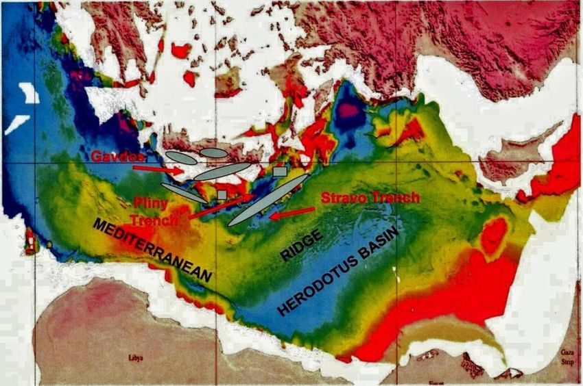
Pytheas
Market
Focus

          The aforementioned scientists
          have indicated that in the wider
          area of Crete there is an active
          geodynamic system that is
          characterized by the motion of
          two converging plates: The
          Eurasian and the African. The
          Arabian Plate moving
          counterclockwise is pushing
          westward the Anatolian Plate
          which in turn pushes southward
          the Aegean Plate (Figure 2). It
          is this interaction of the plates
          which causes the prerequisites
          for hydrocarbon accumulation to
          exist, namely the confluence of
                                            Figure 2. The geodynamic regime of the wider area of Crete and Eastern
          reservoirs, source rocks and a    Mediterranean – The Arabian Plate pushing counterclockwise the Anatolian
          way of getting the oil and gas    Plate which in turn pushes sideways the Aegean Plate; the latter overrides the
          generated from these source       African Plate which sub ducts under the island of Crete, Pavlaki, 2006.
          rocks into the reservoirs and
          keeping them there, trapping them, Kanaswwich and Havskow, 1978. In converging plates we
          usually find large hydrocarbon deposits, Thompson, 1976, Carmalt and St John, 1986.

          In the Eastern Mediterranean the compressional forces are also responsible for the formation
          of an underwater ridge, the so called Mediterranean Ridge (Figure 3). This ridge is forming an
          accretionary complex whose rate of increase is the fastest in the world, Kopf et. al., 2003.

          Figure 3. The Conversion of the African Plate with the Aegean Plate south of Crete in the region of Eastern Mediterranean –
          Distortion of the wider sub-Sea region. Formation of trenches and the Mediterranean Ridge, Pavlaki, 2006.

          2.      The Mediterranean Ridge

          The Mediterranean Ridge (Figure 5), starts from the western part of the island of Lefkas in the
          Ionian Sea, it bends around the island of Crete and ends roughly south of the island of

          Copyright © 2012 Pytheas Limited                         30 March 2012                                                        5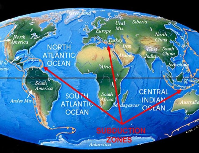
Pytheas
Market
Focus

          Kastellorizo, while following the subduction of the African Plate underneath the Aegean Plate
          (Figure 4). Within this ridge there are two possible hydrocarbon indicators. The first is the
          existence of over 60 mud flow volcanoes, along the subduction zone (Figure 6). The second is
          the occurrence of a large number of accretionary prism complexes (Figures 7 and 8).

          Figure 4. Interpretative 3D tectonic sketch of the Central
          Mediterranean Ridge and the Olimpi and the Southern Belt
          mud fields. Two different source levels are proposed for the
          two mud fields, the Olimpi field being related to relatively     Figure 5. The Mediterranean Ridge and the main geotectonic
          shallow mud formations, with high fluid contents and the         features in Eastern Mediterranean and its wider area of the
          Southern Field being connected to deeper mud sources with        Trans-Mediterranean section (Transmed). VII0 from Moesia
          lower fluid contents, Huguen, et. al., 2005.                     to Cyrenaica, Papanicolaou et. al., 2004.

          Figure 6. Location of mud flow volcanoes in the subduction zone along with the location of the Aegean Volcanic Arc – Location
          of the mud flow volcanoes in the Nile Cone and the Exclusive Economic Zone (EEZ) of Cyprus; within parenthesis the
          anticipated amount of natural gas to be found (modified after Dimitov, 2002).

          Copyright © 2012 Pytheas Limited                         30 March 2012                                                          6
Pytheas
Market
Focus

          Figure 7. Portion of the Trans-Mediterranean section (Transmed VII), starting from Cyrenaica and ending in the Aegean
          Volcanic Arc. Papanicolaou et. al., 2004 from Gavazza et. al., 2004.

          Figure 8. Schematic representation of the geodynamic process which created the Hellenides during the Mediterranean
          Orogenesis and its tectonic migration impact which affected the new subduction zone underneath Crete, Mountrakis 2001,
          Pavlaki 2006.

          A.      Mud Flow Volcanoes

          Mud flow volcanoes within the Greek Exclusive Economic Zone (EEZ) have been and still are
          emitting natural gas bubbles for more than 1 million years. A portion of these gases, after

          Copyright © 2012 Pytheas Limited                       30 March 2012                                                     7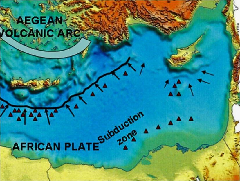
Pytheas
Market
Focus

          travelling through the sea water, are lost in the air
          (Figure 9). Another portion is converted to gas
          hydrates (Figure 10), and another small fraction is
          consumed by methane bacteria. The area covered by
          the gas hydrates is close to 200,000 Km2 and the
          volume is roughly calculated at 30 trillion m3;
          assuming an average thickness of 150 meters
          (Figure 11). Roughly, 1% of this volume are
          hydrates, that is 0.30 trillion m3. This value should
          be multiplied by 170 m3 of natural gas/ 1m3 of
          hydrate in order to equate it to the conventional
          natural gas value, Massari, 2009. This implies that
          we have the equivalent of 51 trillion m3 of natural                       Figure 9. Methane bubbles from the bottom of the
          gas which is a huge amount.                                               Mediterranean Sea.

          Figure 10. Hydrate from the Thessaloniki mud flow
          volcano of Anaximander Mountains, Eastern
          Mediterranean, Lykousis et. al., 2004.

                                                                 Figure 11. Hydrate thicknesses in the Mediterranean Sea, Praeg et. al.,
                                                                 2007. Red line denotes Greece’s EEZ.

          Figure 12. Pockmarks, gas seeps, and the discovery of gas hydrates indicate that the surrounding area is also actively
          degassing through a vent zone, of which the mud volcanoes are a part. The presence of thermogenic gas is inferred from the
          ratio of methane to heavier hydrocarbon gases, indicating a deep source of origin Cronin et al., 1997; Robinson et al., 1996.

          Copyright © 2012 Pytheas Limited                        30 March 2012                                                           8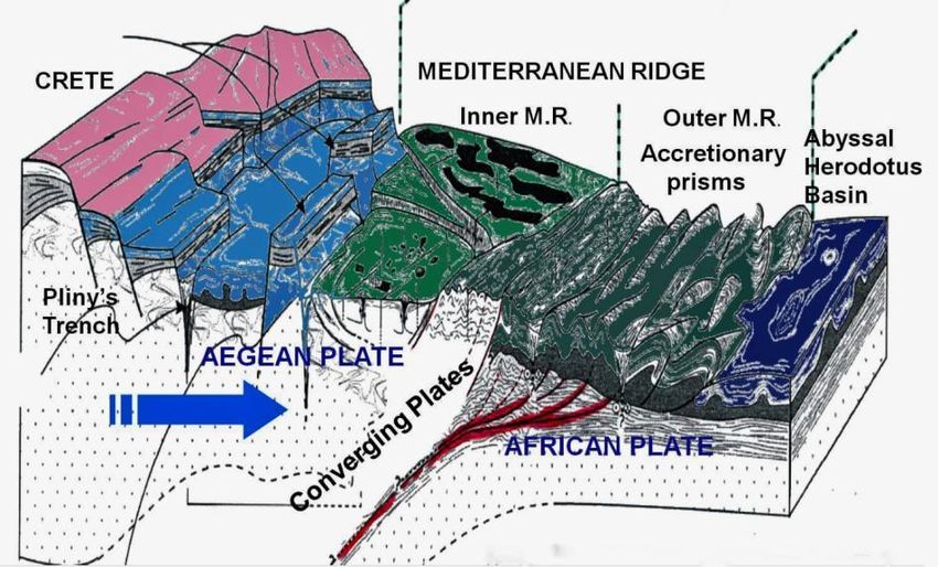
Pytheas
Market
Focus

          Geochemical analysis of the bubbles, which takes into account the ratio of methane/ethane+,
          have indicated that the origin of these bubbles is due to the pyrolysis of hydrocarbons that
          reside at depth – if the ratio of C1/C2+ is far less than 100, then this is considered as strong
          evidence that the gas is thermogenic in origin, whereas if the same ratio is far in excess of
          100, the gas is considered biogenic microbial in origin – Robinson et. al., 1996, Cronin et. al.,
          1997 (Figure 12 above), Robertson and Kopf, 1998 (Figure 13), Deyhle and Kopf, 2012. Gas
          hydrate analysis in shallow deposits of the Amsterdam mud volcano, Anaximander Mountains,
          North-Eastern Mediterranean Sea showed, also, a prevalence of thermogenic light
          hydrocarbons as inferred from C1/C2+ ratios < 35 and δ13C- CH4 values of -50,60/00 , Pape et
          al., 2010 (Figures 14 and 15).

                                                                                                               Active mud flow
                                                                                                               volcanoes are
                                                                                                               associated,
                                                                                                               throughout the
                                                                                                               world, with
                                                                                                               hydrocarbon
                                                                                                               occurrences.
                                                                                                               Offshore Crete, at
                                                                                                               the point where the
                                                                                                               African plate
                                                                                                               submerges there is a
                                                                                                               large number of
                                                                                                               active mud flow
                                                                                                               volcanoes,
                                                                                                               pockmarks and
                                                                                                               pipenecks emitting
                                                                                                               methane for
                                                                                                               thousands of years.
                                                                                                               fields

          Figure 13. Revised model of mud volcanism on the Mediterranean Ridge accretionary
          complex, supported by petrographic and mineralogic data from Leg. 160. Mud volcanism
          was initiated >1 Ma ago, following collision of the to the Mediterranean Ridge accretionary
          complex with a promontory of the North African passive continental margin, Robertson and
          Kopf, 1998.

                                                                                                               Hydrocarbon
                                                                                                               analysis offshore
                                                                                                               Crete on mud
                                                                                                               samples around mud
                                                                                                               flow volcanoes taken
                                                                                                               during the Ocean
                                                                                                               Drilling Program
                                                                                                               indicates again the
                                                                                                               presence of an active
                                                                                                               hydrocarbon system
                                                                                                               at depth

          Figure 14. The relation of C1/C2+ vs δ13 C-CH4 (0/00) and δ13 C-C2H6 (0/00) vs δ13 C-CH4 (0/00) in
          the Amsterdam Mud Flow Volcano, Anaximander Mountain, indicating the thermogenic
          origin of methane bubbles, Pape et. al., 2010.

          Copyright © 2012 Pytheas Limited                            30 March 2012                                                    9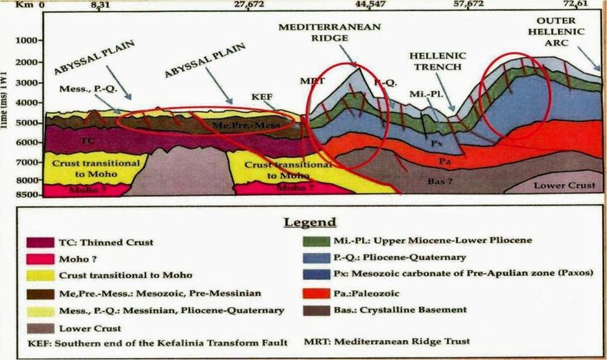
Pytheas
Market
Focus

          Also using the isotope signature of hydrocarbon gases,
          δ13CCH4 < δ13CC2H8 along with the ratio of CH4/C2H6 Toki et.
          al., 2006, it is established that the origin of hydrocarbons in
          the Sagara oil field in central Japan is thermogenic.

          Ranges of gas composition corresponding to (i) bacterial
          gas; (ii) thermogenic, oil-associated gas; (iii) dry, post-
          mature thermogenic gas; and (iv) gas of mixed
          biogenic/thermogenic origin have been defined, facilitating
          the interpretation of gas compositional data by Schoell,
          1983, 1988, Faber et. al., 1992, Whiticar, 1994, Buruss, and
          Laughrey, 2009.

          Some thermogenic bubbles are covered with a liquid
          hydrocarbon sleeve and upon their arrival on the water         Figure 15. Generation of gases from
                                                                         organic matter with increasing
          surface they explode and leave an oil slick. This slick grows
                                                                         temperature, Buruss, and Laughrey, 2009.
          when similar bubbles arrive at the water surface. This
          phenomenon is visible from satellites (Figure 16), Roberts
          and Peace 2007; these analyses, along with the occurrence of oil slicks, leads to the existence
          of working petroleum systems at depth. Pyrolysis of saturates and/or aromatics of oil occur at
          1800C. A geothermal gradient of 330C/1000 meters implies that oil petroleum systems occur
          at a depth of around 5,000 to 5,500 meters, Loncke, 2004 (Figure 17). The same is observed
          also in Exploration Block # 5 of the Cyprus EEZ (Figure 18).

                                                                                        Visible from
                                                                                        satellites, offshore
                                                                                        Crete, a
                                                                                        phenomenon of
                                                                                        thermogenic bubbles
                                                                                        covered with liquid
                                                                                        hydrocarbon sleeve
                                                                                        explode leaving an
                                                                                        oil slick..., indicating
                                                                                        the existence of
                                                                                        petroleum systems

          Figure 16. Oil films resulting from escaping gas bubbles which are
          coated with oil – Gas bubbles are derived from Active Mud Volcanoes
          in offshore Nile Cone, Egypt. Picture taken from satellites, Roberts
          and Peace, 2007.

                                                                                        A geothermal
                                                                                        gradient of
                                                                                        330C/1000 meters
                                                                                        implies that oil
                                                                                        petroleum systems
                                                                                        occur offshore Crete
                                                                                        at a depth of around
                                                                                        5,000 to 5,500
                                                                                        meters

          Figure 17. Active Mud Flow Volcanoes (brown triangles), Gas
          chimneys (brown discs), and Thermogenic Pockmarks and Mounds
          offshore Southern Crete. The pre-Messinian source rocks/ reservoir
          for the mud cones (brown), are highly visible as well as the
          reservoir/source for the gas chimneys (light brown), Loncke et al.,
          2004.

          Copyright © 2012 Pytheas Limited                        30 March 2012                               10
Pytheas
Market
Focus
Figure 18. Large anticline on the toe of deep Nile Delta Fan with Messinian low-stand Delta clastic sand faulted pre-Messinian.
Gas chimneys are highly visible, Montadert and Nikolaides, 2010.
Hydrocarbon analysis on mud samples around mud flow volcanoes taken during the ODP
(Ocean Drilling Program, Leg 160) indicate the presence of an active hydrocarbon system at
depth, Robertson and Kopf 1998.
The geochemical data along with the
immense volumes of hydrates that lie in
the bottom of the Mediterranean Sea (50
trilion m3 of natural gas is equivalent to
328 billion barrels of oil) raises the
question of how much organic matter was
imbedded in the sediments in order to be
converted through diagenesis to kerogen,
subsequently to oil and finally upon
pyrolysis to methane bubbles. This
organic matter, probably phytoplankton,
was buried in pre-Messinian sediments at
depths of more than 5,000 meters in
order to produce pyrolitic methane. Thus,
the origin of methane gases cannot be
attributed to post-Messinian sediments.
Figure 19. The geology of North Africa and Southern Europe
The huge amounts of organic matter is
during Mid Miocene, Scotese, 2000.
most likely phytoplankton accumulated
since the creation of the Tethys Sea, that
is, since the end of the Jurassic, beginning of the Cretaceous, some165 million years ago.
Tethys during the mid-Messinian was a shallow sea (Figure 19), with temperatures similar to
tropical ones. This type of climate was responsible for the production of large quantities of
organic matter which upon burial and diagenesis generated huge amounts of oil and gas.
Hydrocarbon generating conditions in offshore Crete and the Eastern Mediterranean were akin
to those of Saudi Arabia and all the states of the Persian Gulf (Figures 20 and 21). One has to
remember that during the Cretaceous Era the Persian Gulf was the inlet of the Tethys Sea
passing through the Mediterranean to meet the Atlantic Ocean.
Copyright © 2012 Pytheas Limited 30 March 2012 11Pytheas
Market
Focus
Figure 20. Modern world, Scotese 2000.
Figure 21. The Middle East Oil Triangle, Aleklett 2004.
The correlation between mud flow volcanoes and hydrocarbon discoveries can be seen in both
the Egyptian and the Cypriot EEZ (Figures 22 and 23 respectively). More correlations are
reported by Bruneton et. al., 2011. Also, the role of mud volcanoes in petroleum systems can
be easily seen in Timor, South Caspian and the Caribbean Seas, Ware and Ichram, 1997.
Copyright © 2012 Pytheas Limited 30 March 2012 12Pytheas
Market
Focus
Figure 22. Occurrence of mud flow volcanoes and hydrocarbon reservoirs in the Nile Cone and EEZ of Cyprus.
Modified by E. Konophagos from Dupre et. al., 2008 and Robertson, 1996.
Figure 23. Distribution of natural gas reservoirs offshore Egypt, Neftegaz, EU 2010, Rigzone, 2010.
Copyright © 2012 Pytheas Limited 30 March 2012 13Pytheas
Market
Focus
B. Accretionary prism complexes
An accretionary prism is an individual structure which can have one oil or gas field. In
extremely compressed areas, faulting defines individual structures and individual oil and gas
fields. The compression shape does not provide us with giant gas fields. However, the total
accumulated reserves in all structures can be enormous. A different situation can exist in
places with less compressional stresses or extensional areas (As per personal communiqué
with Lucien Montadert, petroleum geologist BEICIP/FRANLAB) structures can be enormous. A
different situation can exist in places with less compressional stresses or extensional areas
(As per personal communiqué with Lucien Montadert, petroleum geologist BEICIP/FRANLAB)
Accretionary prisms are underexplored for
hydrocarbons and may hold large quantities of
hydrocarbon reserves, Dolan et. al., 2004,
(Barbados accretionary prism), Escalona et. al.,
2008, (Barbados accretionary prism), Persad,
2008, (Barbados accretionary prism), Ellouz-
Zimmerman et,al., 2007, (Makran accretionary
prism, Pakistan) Hairms et. al., 1982, (Makran
accretionary prism, Pakistan), Klein et al., 2011
(Peru margin characterized by oceanic/
continental plate collision with accretionary
prisms), Jones et. al., 2011 (West Timor
Trough,) Wandrey, 2006, (Irrawaddy-Andaman
accretionary prism).
In the Mediterranean Ridge accretionary prism Figure 24. The area covered by the Mediterranean Ridge
complexes occupy an area of over 80,000 Km2 accretionary prisms. Its implication for potential
(Figure 24), and starts offshore west of the hydrocarbon reserves, en. Wikipedia org/…./Mediterranean
Ridge.
island of Kefallinia, travels along western
Peloponnese, goes underneath Crete ending
offshore the island of Cyprus (occupying an area of over 80,000 Km2). This area is worth
exploring for hydrocarbon deposits since out of 877 giant oil and gas fields which exist on land
and offshore, while, 71 are encountered within the accretionarry prisms, Mann et., al. 2003.
3. Hydrocarbon potential within the Mediterranean Ridge
Though there is substantial geophysical information concerning the offshore geology of Crete,
Astrium, EADS Co. (Figure 25) and PGS information (Figure 26), these data are unavailable to
Greek scientists. However, Zelilidis, 2011, and Maravelis et al., 2012, using data from Leite
and Mascle, 1982, Truffert et. al., 1993 and Kokinou et. al., 2006, have identified the
stratigraphy, the geological evolutionary stages and basin
configurations offshore Crete which lead to possible hydrocarbon A large number of
fields consisting mainly of gas. The possible areas are two major accretionary prisms
anticlines and an abyssal plain, while another seven backstop encountered within
the Mediterranean
basins-trenches represent possible hydrocarbon plays (Figures 27,
Ridge, offshore
28, and 29). Also, Robinson 2011 of Petroleum Geo-Services (PGS), Crete, whose length
during his oral presentation at the Department of Energy and is over 1,000 Km,
Climatic Changes (YPEKA), showed from the point of hydrocarbon indicate the
prospectivity that the southern basin of Crete is very similar to the existence of large to
West Timor Trough, Jones et al., 2011, as well as the Levantine giant hydrocarbon
basin (Figures 30 and 31). PGS is very familiar with Levantine basin. deposits
The fact that USGS, Technical Report 2010, has assessed the
Levantine Basin to have, on 50% chance, 123 trillion cubic feet of natural gas and 1.7 billion
barrels of gas condensate creates a very favourable climate for hydrocarbon exploration in
offshore Crete. Zelilidis, 2011, and Maravelias et. al., 2012 have also concluded that there are
several potential hydrocarbon plays as well as structural and stratigraphic traps. The same
belief is shared also by Robinson 2011.
Copyright © 2012 Pytheas Limited 30 March 2012 14Pytheas
Market
Focus
Figure 25. Geological and geophysical data maps by ASTRIUM, an EADS Co.
Figure 26. Existing seismic coverage information package limited to Prinos and Sea of Thrace area (seismic data acquired by
unknown companies in the 90’s, 00’s and 2009). Robinson, J. PGS multi-client presentation at Ministry of Energy and Climatic
Changes, (YPEKA) Athens, Greece, July 2011.
Copyright © 2012 Pytheas Limited 30 March 2012 15Pytheas
Market
Focus
Figure 27. Possible hydrocarbon plays offshore southern Crete. Two major anticlines (ellipsoidal red circles) and the Hellenic
trench, 2 Km below sea level. Also, Abyssal Plain ( Oval red Circle). Zelilidis, 2011.
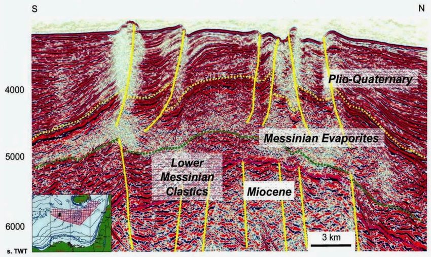
Figure 28. Example from the six backstop basins southward of Crete (Gavdos, Gortys, Poseidon, Ptolemeus, Pliny and Stravon
trenches). Interpretation of seismic reflection profiles across the western south Cretan Trench. P.Q. recent sedimentary cover.
uM, Miocene evaporite and related tectonics, Maravelis et al., 2012.
Copyright © 2012 Pytheas Limited 30 March 2012 16Pytheas
Market
Focus
Figure 29. Hydrocarbon Fields, pale blue oval circles, offshore Crete according to Maravelis et. al., 2012.
Figure 29. Hydrocarbon potential in Greece. Source rocks, Reservoirs, Seals Traps and Type basin. Presentation of PGS by J.
Robinson at the ministry of Energy and Climatic Changes, Athens, Greece (ΥΠΕΚΑ), 2011.
Copyright © 2012 Pytheas Limited 30 March 2012 17Pytheas
Market
Focus
Figure 31. The Levantine Basin with its recent oil and gas discoveries. Assessed potential for further discoveries of
natural gas 122 tcf (3.45 tcm) and oil 1.7 billion barrels, USGS Technical Report, 2010.
4. Conclusions
1. Converging plates host large hydrocarbon fields. In the Eastern Mediterranean, the
Aegean plate overrides the African plate underneath the island of Crete. Henceforth, the
possibility of having large hydrocarbon deposits should be investigated.
2. Accretionary prisms, throughout the world (Barbados, Makran, Irrawaddy-Andaman,
West Timor Trough) are indicative of giant hydrocarbon deposits. A large number of
accretionary prisms are encountered within the Mediterranean Ridge whose length is
over 1,000 Km, Hence, the existence of large to giant hydrocarbon deposits should be
the subject of intense exploration research.
3. Active mud flow volcanoes are associated, throughout the world, with hydrocarbon
occurrences (Timor, South Caspian Sea, the Caribbean, Egypt and Cyprus). Underneath
Crete, at the point where the African plate submerges there is a large number of active
mud flow volcanoes, pockmarks and pipenecks emitting methane for thousands of
years. As a result a thorough investigation could reveal giant oil fields.
Copyright © 2012 Pytheas Limited 30 March 2012 18Pytheas
Market
Focus
4. Geochemical analysis of emitted methane bubbles from active mud flow volcanoes
indicates that their origin is thermogenic. This implies that pyrolysis or better thermal
cracking of hydrocarbons takes place at depth where temperatures are 1600C to 1800C.
Based upon a geothermal gradient of 330C/1000 meters, pyrolysis should take place at
a depth between 5,000 to 5,500 meters. Hence, working petroleum systems are
encountered at depth while the thickness of the sediments, below sea level, is over
5,000 meters.
5. Hydrocarbon analysis on mud samples around mud flow volcanoes taken during the
Ocean Drilling Program (ODP) indicates again the presence of an active hydrocarbon
system at depth.
6. Based upon geological and geophysical data, Greek scientists have identified offshore
Crete within the Mediterranean Ridge two major anticlines, an abyssal plain and seven
backstop basin-trenches as possible hydrocarbon plays.
7. Based upon the geological similarities and their vast experience in both the Eastern
Mediterranean and the West Timor trough, Petroleum Geo-Services (PGS) have
suggested that the Southern basin of Crete is equivalent to the Levantine basin. This
result implies that the potential to discover natural gas and oil in offshore Crete is very
strong.
Copyright © 2012 Pytheas Limited 30 March 2012 19Pytheas
Market
Focus
The conclusions of the Paper in the Greek language:
ΟΙ ΣΥΓΚΛΙΝΟΥΣΕΣ ΛΙΘΟΣΦΑΙΡΙΚΕΣ ΠΛΑΚΕΣ ΚΑΙ Η ΤΑΥΤΟΧΡΟΝΗ ΥΠΑΡΞΗ
ΠΡΙΣΜΑΤΩΝ ΕΠΑΥΞΗΣΗΣ ΚΑΙ ΛΑΣΠΟΗΦΑΙΣΤΕΙΩΝ ΣΤΗΝ ΜΕΣΟΓΕΙΑΚΗ ΡΑΧΗ ΩΣ
ΔΕΙΚΤΕΣ ΥΠΑΡΞΗΣ ΚΟΙΤΑΣΜΑΤΩΝ ΥΔΡΟΓΟΝΑΝΘΡΑΚΩΝ ΣΤΗΝ ΠΑΡΑΚΤΙΟ ΝΟΤΙΑ ΚΡΗΤΗ.
ΝΕΕΣ ΠΡΟΟΠΤΙΚΕΣ ΕΝΤΟΠΙΣΜΟΥ ΚΟΙΤΑΣΜΑΤΩΝ ΥΔΡΟΓΟΝΑΝΘΡΑΚΩΝ ΣΤΗΝ ΕΛΛΑΔΑ.
Συμπεράσματα
1. To 20% των γιγαντιαίων κοιτασμάτων υδρογονανθράκων απαντάται στα σημεία σύγκλισης
των λιθοσφαιρικών πλακών. ‘Άρα η ύπαρξη κοιτασμάτων υδρογονανθράκων στην
υπεράκτιο Νότια Κρήτη θα πρέπει να διερευνηθεί.
2. Τα Πρίσματα Επαύξησης σε όλο τον κόσμο, (Barbados, Makran, Irrawaddy – Andaman,
West Timor Trough) είναι δείκτες ύπαρξης γιγαντιαίων κοιτασμάτων υδρογονανθράκων.
Επομένως, η ύπαρξη κοιτασμάτων υδρογονανθράκων στην υπεράκτιο Νότια Κρήτη θα
πρέπει να διερευνηθεί δεδομένου ότι τα επαυξητικά πρίσματα βρίσκονται στην Μεσογειακή
Ράχη που έχει μήκος πάνω από 1,000 χιλιόμετρα.
3. Ενεργά λασποηφαίστεια σε όλο τον κόσμο προδίδουν την ύπαρξη γιγαντιαίων κοιτασμάτων
υδρογονανθράκων (Timor, Καραϊβική Θάλασσα, Νότια Κασπία Θάλασσα ήτοι Αζερμπαϊτζάν,
Ιράν, Μαύρη Θάλασσα, ήτοι Ρουμανία, Ρωσία και Τουρκία, Ανατολική Μεσόγειος, ήτοι
Αίγυπτος, Κύπρος και Τουρκία). Επομένως, η ύπαρξη κοιτασμάτων υδρογονανθράκων στην
υπεράκτιο Νότια Κρήτη θα πρέπει να διερευνηθεί.
4. Γεωχημικές αναλύσεις των φυσαλίδων του μεθανίου που εκλύονται από τα ενεργά
λασποηφαίστεια τα οποία απαντώνται στον υποθαλάσσιο χώρο της Κρήτης δείχνουν με
σαφήνεια ότι η προέλευσή τους δεν είναι βιογενετική αλλά θερμογενετική/πυρολυτική.
Αυτό σημαίνει ύπαρξη κοιτασμάτων αργού πετρελαίου. Επομένως, η ύπαρξη κοιτασμάτων
υδρογονανθράκων στην υπεράκτιο Νότια Κρήτη θα πρέπει να διερευνηθεί.
5. Σε δείγματα ιλύος που λήφθησαν κατά την διάρκεια του προγράμματος Ocean Drilling
Program (ODP) γύρω από τα ενεργά λασποηφαίστεια της Κρήτης πιστοποιήθηκε η ύπαρξη
υγρών υδρογονανθράκων στα δείγματα. Και αυτή η ένδειξη μας υποδεικνύει την ύπαρξη
συστήματος πετρελαιογένεσης σε μεγάλα βάθη (the presence of an active hydrocarbon
system at depth).
6. Με βάση τα γεωλογικά και γεωχημικά δεδομένα όπως επίσης τα πολύ λίγα γεωφυσικά
στοιχεία που έχουν στην διάθεσή τους ορισμένοι μόνον Έλληνες Πανεπιστημιακοί, ότι στην
υπεράκτιο υπάρχουν στην Νότια Κρήτη και εντός της Μεσογειακής Ράχης δύο (2) μεγάλα
αντίκλινα, μία (1) αβυσσική λεκάνη και επτά (7) οπισθοτάφροι που μπορούν να
αποτελέσουν πεδία έρευνας για τον εντοπισμό κοιτασμάτων υδρογονανθράκων.
7. Η Νορβηγική εταιρεία γεωφυσικών ερευνών Petroleum Geo-Services (PGS) με βάση τις
μελέτες που έχουν γίνει νότια της Κρήτης, εν αγνοία των ελληνικών κυβερνήσεων,
διαπίστωσε από την εμπειρία της με τις μελέτες που έκανε στην Ανατολική Μεσόγειο ότι
υπάρχουν τεράστιες γεωλογικές ομοιότητες με την λεκάνη της Λεβαντίνης, (ΑΟΖ Κύπρου,
Ισραήλ, Συρίας και Λιβάνου) η οποία θεωρείται από την Γεωλογική Υπηρεσία των ΗΠΑ
(USGS) ότι έχει τουλάχιστον 3.45 τρις. m³ φυσικού αερίου και 1,7 δισ. βαρέλια αργού
πετρελαίου. Άρα επιβάλλεται η έρευνα για τον εντοπισμό κοιτασμάτων υδρογονανθράκων
νοτίως της Κρήτης.
Copyright © 2012 Pytheas Limited 30 March 2012 20Pytheas
Market
Focus
The Authors
Mr. Alain BRUNETON, a Geologist and Geophysicist, is an independent
consultant. Mr. Bruneton worked with BEICIP-FRANLAB as a processing
geophysicist and at its joined seismic interpretation group. At BEICIP-FRANLAB
he was also in charge of its geophysical department. He has worldwide
experience in basin interpretation, and oil and gas field studies using modern
technologies, i.e. 3D and AVO, as well as interpretation workstations, i.e.
A. Bruneton Landmark and Kingdom Suite.
Selected publication titles include: “Petroleum potential of the Niger Grabens” (Journal
Petroleum Geology); “The structural and tectonic framework of Western Greece”
(Tectonophysics); “AVO anomalies study in the Gharb Basin” (AAPG). “The petroleum
potential of East Mediterranean Offshore”; “The economic and geopolitical importance of
Eastern Mediterranean gas fields”.
Mr. Bruneton holds a Master of Sciences in Geology and an ENSPM in Geology and
Geophysics.
Dr. Elias KONOFAGOS, a Chemical Engineer of Oil & Gas Production, is the
Executive Vice-President of FLOW Energy S.A., a high level E&P consulting
services company. He started his career with Elf Acquitaine (North Sea Heimdal
Gas Field Development), then with Mobil North Sea in Stavanger (Statfjord-B Oil
& Gas Field). He worked with the Public Petroleum Corporation of Greece S.A.
(supervision of Prinos Oil Field & South Kavala Gas Field Developments) and the
E. Konofagos Public Petroleum Corporation Exploration & Production S.A. (execution of the
First Licensing Round in Greece). He also acted as International E&P General
Director at Hellenic Petroleum S.A.
Having an extensive worldwide Oil & Gas Exploration and Production experience in Managing
E&P assets, creating value and improving business performance, he published more than 80
scientific papers and studies internationally.
Dr. Konofagos was awarded a PhD (Docteur d’ Etat es Sciences) of Chemical Engineering on
Oil & Gas Production by the École Polytechnique Fédérale de Lausanne and he is an IFP
Petroleum Economics & Greek Eisenhower Fellow (on Oil Exploration & Production & Energy).
Dr. Anthony E. FOSCOLOS is an Emeritus Professor at the Technical University
of Crete and an Emeritus Research Scientist at the Geological Survey of Canada.
Upon completing his graduate studies at the University of California Berkeley
(1966), he was hired by the Geological Survey of Canada, Institute of
Sedimentary and Petroleum Geology to carry research in the area of
hydrocarbons in Central Alberta, Northeastern British Columbia, the Beaufort
A.E. Foscolos MacKenzie Region and the Canadian Arctic Islands; one third of his publications
are related to these scientific activities. In 1986 he was elected as a professor at
the Technical University of Crete, Department of Mineral Resources Engineering. His teaching
was related to the field of Inorganic and Organic Geochemistry and Organic Petrology. Dr.
Foscolos also served as its Academic Vice President (1966-1997) and the Head of the
Department of Mineral Resources Engineering (1988-1993). He has also been an energy
consultant for the United Nations Development Program (1995-1997), and Adjunct Professor,
Department of Geography and Archaeology, University of Calgary (1975-1986).
His scientific record includes 74 publications, most of them in peer review journals, with a
Citation Index of 243 (till 2003), 33 participations at International and National Conferences
with presentations and posters and 14 Technical Reports for the Public Petroleum Corporation
of Greece (DEP-EKY), Public Power Corporation of Greece, S.A. (DEH), Institute of Mineral
Exploration, Greece (IGME) and the United Nations.
Copyright © 2012 Pytheas Limited 30 March 2012 21Pytheas
Market
Focus
Sources and Bibliography (Alphabetically)
► Aleklet, K. 2006. The Swedish plan for independence on oil. Pisa, Italy, July 2006.
► Barrier, E., Chamot-Rooke, N., Giordano, G. 2004. Geotectonic Map of the Mediterranean, sheet 1,
(Tectonics and Kinematics), Commission for the Geological Map of the World (CCGM)/CGMW), Edition,
Paris, France.
► Bruneton, A., Konofagos, E., Foscolos, A. 2011. Economic and Geopolitical Importance of Eastern
Mediterranean gas fields for Greece and the EU. Emphasis on the Probable Natural Gas Deposits Occurring
in the Libyan Sea within the Exclusive Economic Zone of Greece. Mineral Wealth, v 160 pp.7-22.
► Buruss, R. C., Laughrey, C.D. 2009. Covariation of carbon and hydrogen isotopic composition in natural
gas: Separating biogenic, thermogenic and Abiotic (inorganic CO2 reduction) source USGS.
► Carmalt, S. W., St John, B. 1986. Future Petroleum Provinces of the World. Giant oil and gas fields. AAPG
Special Volumes, volume M 40. pp 11-53.
► Cocard M., Kahle H-G., Peter Y., Geiger A., Veis G., Felekis S., Paradisis D. and Billiris H. 1999: "New
constraints on the rapid crystal motion of the Aegean region: recent results inferred from GPS
measurements (1993-1998) across the West Hellenic Arc, Greece". Earth and Planetary Science Letters,
172, 39-47.
► Cronin, B.T., Ivanov, M.K., Limonov, A. F., Egorou, A., Akhmanov, G.G., Akhmetjanov A.M., Kozlova. E.
1997. TTR Shipboard Scientific Party 1997. New discoveries of mud volcanoes on the Eastern
Mediterranean Ridge. Journal of the Geological Society of London 154 (2) pp. 173-182.
► Deyhle, A., Kopf, A. 2012. Deep fluids and ancient pore waters at the backstop: Stable isotope
systematics (B, C, O) of mud-volcano deposits on the Mediterranean Ridge accretionary wedge. Geology
2001; 1031-1034 doi : 10.1130/0091-7613 (2001)0292.0.CO; 2.
► Dimitrov, L. 2002. Mud volcanoes, the most important pathway for degassing deeply buried sediments.
Earth Science Reviews 59, pp 47-76.
► Dolan, P., Burggraf, D,. Soofi, K., Fitzsimmons, R., Aydemir, E., Senneseth, O., Strickland, L. 2004.
Challenges to exploration in frontier basins-The Barbados accretionary prism. AAPG International
Conference, October 24-27, Cancun, Mexico.
► Dupre, S., Buffet, G., Mascle, J., Foucher, J-P., Gauger, S, Boetius, A., Marfia. C., The AsterX AUV Team,
The Quest ROV Team and The BIONIL scientific party. 2008. High-resolution mapping of large gas emitting
mud volcanoes on the Egyptian continental margin (Nile Deep Sea Fan) by AYV surveys. Marine
Geophysical Researches, v.29, No. 4, pp. 275-290.
► Ellouz-Zimmerman, N., Deville., E. Muller, C, 2007. Thrust belts and foreland basins : from kinematics
to hydrocarbon. Books.google.gr/pp471 books? ISBN=3540694250. Publishers, Olivier Lacombe, Societe
Geologique de France and Sociedad, Geologica de Espagna.
► Faber, E. W., Stahl, J., Whiticar, M.J. 1992. Distinction of bacterial and themogenic hydrocarbon gases, in
R. Vially, ed., Bacterial Gas, Paris Editions Technip, pp.63-74.
► Escalona, A., Mann, P., Bingham, L. 2008. Hydrocarbon exploration plays in the Great Caribbean region
and neighboring provinces. 2008. AAPG Annual Convention, San Antonio Texas April 20-23. Search and
Discovery Article # 10047. Posted July, 2008.
► Gavazza, W., Roure, F., Spackman, W., Stampfli,G., Ziegler, P (Eds), 2004. The Mediterranean Region
from Crust to Mantle. The Transmed Atlas. Geological and Geophysical Framework of the Mediterranean
and the Surrounding Areas. A publication of the Mediterranean Consortium for the 32nd International
Geological Congress, Florence, Italy, August, 20-28, 2004.
► Hollenstein Ch., Kahle H.-G., Cocard M., Veis G., Paradissis D., Felekis S. and Billiris H. 2002: "CGPS
data in Greece: Time Series of Crystal Motion and Error Analysis". Proc: WEGENER conference 2002,
Eleventh General Assembly, Athens, 12-14 June, p.4.
► Jackson J. 1994: "Active tectonics of the Aegean region". Annual Reviews of Earth and Planetary Sciences
22, 239-271.
► Jones, W., Tripathi, A., Rajagopal, R., Williams, A. 2011. Accretionary prisms-plate tectonics-
Hydrocarbons. Petroleum prospectivity of the West Timor trough
(www.pnronline.com.au/article.php/127/150).
► Hairms, J., S. Cappel, H., N. Francis, D., C 1982. Geology and petroleum potential of the Makran coast,
Pakistan. Society of Petroleum Engineers. ISBN: 978-1-55563674-6, DOI: 102118/10423-MS.
► Huguen C., Mascle J., Chaumillon E., Woodside J.M., Benkhelil J., Kopf A. and Volokonskaia A. 2001:
"Deformation styles of the eastern Mediterranean Ridge and surroundings from combined swatch mapping
and seismic reflection profiling". Tectonophysics, 343, 21-47.
► Huguen, C., Mascle, J., Woodside, J. M., Zitter, T. 2005. An in situ and near- bottom study of Mud
Volcanoes in the Eastern Mediterranean Pre-Collisionnal Setting. Deep Sea Res. I 52, 1911-1931.
► Klein, G.D., Zuniga-Rivero, J., Hay-Roe, H., Alvarez-Calderon, E., 2011. Mesozoic/Cenozoic tectonic
evolution, basin fairways and play opportunities, Peru. Sipes Houston Chapter Meeting, Septeptember 15.
2011.
► Kanasewich, E. R., Havskov, J. 1978. Plate tectonics and the location of oil fields.
► Kokinou, E., Papadimitriou, E., Karakostas, V., Kamberis, E. and Vallianatos, F. 2006. The Kefalonia
Transform Zone (offshore Western Greece) with special emphasis to its prolongation towards the Ionian
Abyssal Plain. Marine Geophysical Research 27:241-252.
► Knapmeyer M. and Harjes H-P., 2000: "Imaging crystal discontinuities and the down going slab beneath
western Crete". Geophys. J. Int., 143, 1-21.
► Kopf A., Mascle J. and Klaeschen D. 2003: "The Mediterranean Ridge: A mass balance across the fastest
growing accretionary complex on Earth". Journal of Geophys. Research, Vol. 108, No B8, 2372, doi:
10.1029/2001JB000473.
Copyright © 2012 Pytheas Limited 30 March 2012 22Pytheas
Market
Focus
► Kreemer C. and Chamot - Rooke 2004: "Contemporary kinematics of the Southern Aegean and the
Mediterranean Ridge". Geophys, J. Int., 157, 1377-1392.
► Leite, O., Mascle, L. 1982. Geological structure of the south Cretan continental margin and Hellenic
trench. Marine Geology, v. 49 pp. 199-223.
► Le Pichon 1982: "Land-locked oceanic basins and continental collision: The Eastern Mediterranean as a
case example". In: Hsu, K. (ed) Mountain Building Processes. Academic Press, London, 201-211.
► Loncke, L., Mascle, J., Fanil Scientific Parties. 2004. Mud volcanoes, gas chimneys, pockmarks and
mounds in the Nile deep-sea fan (Eastern Mediterranean): Geophysical evidence. Marine and Petroleum
Geology v.21. pp. 669-689.
► Lykousis, V, Alexandri, S., Woodside,, J., Nomikou, P. Perissoratis, C, Sakelllariou, D., de Lange, G.,
Dahlmann, A, Casas, D. Rousakis, G., Ballas, D, Ioakim, C.2004. New evidence of extensive active mud
volcanism in the Anaximander Mountains (Eastern Mediterranean). The “ATHINA“ mud volcano.
Environmental Geology 46, 1030–1037.
► Mann, P., Galagan, L., Gordon. M.P. 2003 Tectonic settings of the world’s giant oil and gas fields. AAPG
Special Volume. Memoir 78: Giant oil and gas fields of the decade 1990-1999, pp. 15-105.
► MacKenzie D. P. 1972: "Active tectonics of the Mediterranean region". Geophys. Journal of the Royal
Astronom. Society, 30, 109-185.
► Massari, S. 2009. Technical feasibility for the exploitation of methane hydrates. J. Commodity Sci.
Technol. Quality 2009, 48 (II), 121-138.
► Maravelis, A., Manutsoglu, E.,Konstantopoulos, P., Pantopoulos,G., Makrodimitras, G., Zampouli,
E.,Zelilidis, A. 2012. Hydrocarbon plays and prospectivity of the Mediterranean Ridge. Energy Sources,
Accepted and In press.
► McLusky S. et al 2000: "Global Position System constraints on plate kinematics and dynamics in the
eastern Mediterranean and Caucasus". Journal of Geophysical Research, 105, 5695-5719.
► McLusky, Reilinger R., Mahmoud S., Ben Sari D., and Tealeb A. 2003: "GPS constraints on Africa (Nubia)
and Arabia plate motions". Geophys. J. Int. 155, 126-138.
► Meulenkamp J.E., Wortel M.J.R., VanWamel W.A., Spakman W. and Hoogerduyn Strating E. 1988: "On
the Hellenic subduction zone and the geodynamic evolution of Crete since the late Middle Miocene".
Tectonophysics, 146, 203-215.
► Montadert, L., Nikolaides, S. 2007. The Geological structure of the Eratosthenes Continental Block and its
Margins with the Levantine and Herodotus Basins (Eastern Mediterranean) from New Seismic Reflection
Data. AAPG Search and Discovery Article # 90072. AAPG and AAPG European Region Conference, Athens,
Greece.
► Μουντράκης Δ., 2001: "Τεκτονική εξέλιξη του Ελληνικού Ορογενούς. Γεωμετρία και κινηματική της
παραμόρφωσης". Πρακτ. 9ου Διεθν. Συνεδρ. Ελλην. Γεωλ. Εταιρ., Αθήνα, Δελτ., Τομ. ΧΧΧΙV/6, 2113-2126.
► Minster J.B. and Jordan T.H. 1978: "Present day plate motions". Journal of Geophy-sical Research, 83,
5331- 5334.
► Nefregaz. RU. Oil and gas worldwide, 2010. Offshore oil treasures in East Mediterranean sea.
► Oral M.B., Reilinger R.E., Toskoz M.N., King R.W., Barka A.A., Kiniki J. and Lenk D. 1995: "Global
Positioning System offers evidence of plate motions in Eastern Mediterranean". EOS, 76, 9-11.
► Papanicolaou, D.,Barghati, H., Dabroski, C., Dimitriou, R., El-Hawat, A., Joane, D., Kranis. H., Obeidi, A.,
Gale, G., Seghed, A., Zagorchev, I. 2004. Transect VII. East European Craton-Scythian Platform-
Dobrogea-Balkanides-Rhodope Massif-Hellenides-East Mediterranean. The Transmed Atlas. Geological and
Geophysical Framework of the Mediterranean and the Surrounding Areas. A publication of the
Mediterranean Consortium for the 32nd International Geological Congress, Florence, Italy, August, 20-28,
2004.
► Papazachos C.B. 1999: "Seismological and GPS evidence for the Aegean-Anatolia interaction". Geophys.
Res. Lett., 26, 2653-2656.
► Papazachos C.B. 2002: "A tecto-Kinematic model for the Aegean using seismological and GPS data".
Proc., 11th Gen. Ass. WEGENER, 12-14 June, 2002.
► Παπαζάχος Β. Κ. και Παπαζάχου Κ. Β. 2003: "Οι σεισμοί της Ελλάδας". Εκδόσεις Ζήτη, γ΄ έκδοση,
Θεσσαλονίκη, σελ. 286.
► Pape, T., Kasten, S., Zabel, M., Bahr, A., Abegg, F., Hohnerg, H-J., Bohrmann, G. 2010. Gas hydrates in
shallow deposits of the Amsterdam mud volcano, Anaximander Mountains, Northeastern Mediterranean
Sea.Geo-Mar Lett. V. 30, pp 187-206. DOI 10.1007/s00367-010-0197-8.
► Pavlaki Cath, 2006: “Engineering geology conditions at Chania Prefecture”. PhD Thesis, Aristotle
University of Thessaloniκi - Department of Civil Engineering, p. 540.
► Παυλάκη Αικ. 2006. "Τεχνικές Γεωλογικές Συνθήκες στο Νομό Χανίων". Διδακτορική διατριβή, Τμήμα Πολ.
Μηχ/κών - Αριστοτέλειο Πανεπιστήμιο Θεσσαλονίκης, σελ. 540.
► Persad, K.M. 2008. Petroleum geology and prospects of Trinidad and Tobago. 100 years of petroleum in
Trinidad and Tobago (www.energy.gov.tt/content/Centenery_Pub_Krishna_Persad.pdf).
► Praeg, D., Unnithan, V., Camerlenghi, A. 2007. PROJECT: HYDRAMED. Gas hydrate stability and
prospectivity in the Mediterranean sea (www.dur.ac.uk/ey.go/general_public/AAPG_Newsletter_June.pdf).
► Reilinger R., McClusky S. and Vernant Ph. 2004: "GPS constraints on continental deformation in the
eastern Mediterranean and Caucasus region. (1988-2004)". E. Mediterranean and Caucasus GPS
Consortium, Centre for the Observation and Modeling of Earthquakes and Tectonics.
► Roberts, G., Peace, D. 2007. Hydrocarbon plays and prospectivity of the Levantine Basin, offshore
Lebanon and Syria from modern seismic data. Geoarabia, v.12. No 1, pp. 99-124.
► Robertson, A., H., F. and Kopf. A. 1998 Proceedings of the Ocean Drilling Program, Scientific Results,
Vol. 160 Robertson, A.H.F., Emeis, K.-C., Richter, C., and Camerlenghi, A. (Eds.), 1998.
Copyright © 2012 Pytheas Limited 30 March 2012 23You can also read