Dawn of drone ecology: low-cost autonomous aerial vehicles for conservation
←
→
Page content transcription
If your browser does not render page correctly, please read the page content below
Mongabay.com Open Access Journal - Tropical Conservation Science Vol.5 (2):121-132, 2012

  Conservation Letter

  Dawn of drone ecology: low-cost autonomous
  aerial vehicles for conservation

  Lian Pin Koh1,2* and Serge A. Wich3,4
  1
    Department of Environmental Systems Science, ETH Zurich, CHN G 73.2, Universitatstrasse 16, CH-8092,
  Switzerland
  2
    Department of Biological Sciences, National University of Singapore, 14 Science Drive 4, Singapore 117543
  3
    Anthropological Institute and Museum, Universitat Zürich, CH-8057 Zürich, Switzerland (e-mail:
  sergewich1@yahoo.com)
  4
    Sumatran Orangutan Conservation Program (PanEco-YEL), Medan 20154, Indonesia
  *To whom all correspondence should be addressed (e-mail: lian.koh@env.ethz.ch)

Abstract
Tropical deforestation continues to be a major driver of biodiversity loss and greenhouse gas emissions. Remote sensing
technology is increasingly used to assess changes in forest cover, species distributions and carbon stocks. However, satellite
and airborne sensors can be prohibitively costly and inaccessible for researchers in developing countries. Here, we describe
the development and use of an inexpensive (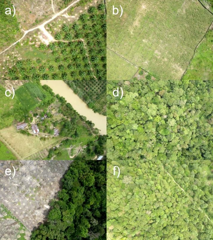
Mongabay.com Open Access Journal - Tropical Conservation Science Vol.5 (2):121-132, 2012

Introduction
Tropical deforestation is a major contributor to greenhouse gas emissions and biodiversity loss [1]. In
Southeast Asia, for example, forest conversion to plantations of oil palm, rubber, cacao, and Acacia spp.
(for pulp and paper) has resulted in deforestation and forest degradation [e.g., ref. 2]. These rapid and
widespread land-use changes have severely affected tropical biodiversity [3, 4]. As global demands for
food and biofuels continue to place increasing pressures on land in the tropics, an urgent challenge for
conservationists is to be able to accurately assess and monitor changes in forest cover, species
distributions and population dynamics.
Most conservation researchers and practitioners currently rely on satellite-based remote sensing for
mapping and monitoring land use change [5]. However, remote sensing technology might not be
accessible for many developing-country researchers due to financial constraints. Although certain low-
resolution satellite images are freely available (e.g., Landsat [landsat.gsfc.nasa.gov] and MODIS
[modis.gsfc.nasa.gov]), other sub-meter resolution images can be prohibitively costly (e.g., QuickBird
[digitalglobe.com], IKONOS [geoeye.com]). Yet, such high-resolution data are often critical for accurately
detecting and tracking land use change at the landscape scale (< 1,000 ha). Furthermore, much of the
humid tropics is often obscured from remote sensing satellites due to a persistent cloud cover [6]. As
such, cloud-free satellite images for a specific time period and location are often not readily available.
Researchers typically have to search from a time series of images to obtain the cloud-free data they
require, thus rendering any real-time monitoring of land-use change practically impossible.
The second major conservation challenge concerns assessment and monitoring of biodiversity. Currently,
this is largely achieved through ground surveys, which can be time-consuming, financially expensive, and
logistically challenging in remote areas [7]. For example, ground surveys of orangutan populations
(Pongo spp.) in Sumatra, Indonesia can cost up to ~$250,000 for a two-year survey cycle. Due to this high
cost, surveys are not conducted at the frequency required for proper analysis and monitoring of
population trends [8]. Furthermore, some remote tropical forests have never been surveyed for
biodiversity due to difficult and inaccessible terrain [9].
To address these challenges, we are developing the use of inexpensive (

Mongabay.com Open Access Journal - Tropical Conservation Science Vol.5 (2):121-132, 2012

mAh (milliampere-hour) battery, which allowed it to fly for ~25 minutes per mission, and over a total
distance of ~15 km.

                                                           Fig. 1. The prototype of the Conservation
                                                           Drone used in test missions in Sumatra,
                                                           Indonesia.

                                                           Fig. 2. APM Planner software used to plan
                                                           the flight paths of each drone mission.

We equipped the drone with one of two still-photograph cameras during its test flights. The first was a
Canon IXUS 220 HS (resolution: 4000 x 3000 pixels; sensor: Complementary Metal-Oxide-Semiconductor;
sensor size: 6.17 x 4.55 mm). The second was a Pentax Optio WG-1 GPS (resolution: 4288 x 3216 pixels;
sensor: Charge-Coupled Device; sensor size: 6.17 x 4.55 mm). Either camera was placed within the
airplane’s fuselage at about 15 cm behind the nose. To allow for extension of camera lens, a rectangular
window was excised from the floor of the fuselage (~3 x 4 cm).
We replaced the original firmware of the Canon camera with a Canon Hack Development Kit
(chdk.wikia.com). This ‘hacked’ firmware allows us to implement a customized intervalometer script to
command the camera to take photographs at user-specified time intervals (e.g., every 3 seconds). This
script also allows the user to define several other parameters including: i) time-delay before the camera
begins taking pictures, ii) focal length of camera lens, and iii) time before camera automatically shuts
down and retracts its lens. We used the Pentax camera without modification as it already has a built-in
interval shot function.
The Conservation Drone can also be equipped with a video camera. We used a GoPro HD Hero camera
housed within a protective shockproof casing (gopro.com). This camera was attached to the belly of the

           Tropical Conservation Science | ISSN 1940-0829 | Tropicalconservationscience.org
                                                  123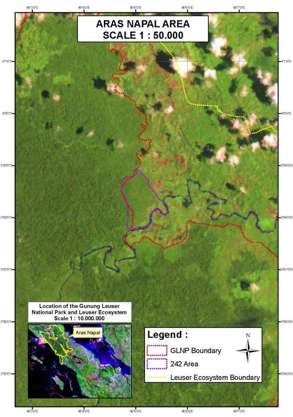
Mongabay.com Open Access Journal - Tropical Conservation Science Vol.5 (2):121-132, 2012

plane and pointed at ~45 degrees forwards and downwards. During our test flights, all video footages
were taken at a resolution of 1080 x 720 pixels and at 60 frames per second.
Using the APM Planner (version 1.1.26), we programmed the flight path of each mission by clicking on
waypoints in a Google satellite map interface (Fig. 2). The drone can be programmed to take off and land
autonomously, and circle over any waypoint for a specified number of turns or duration. Users could also
program other flight parameters such as ground speed and altitude of each waypoint. Each pre-
programmed mission was uploaded to the drone, which would then fly the mission autonomously.

Study area
The prototype Conservation Drone was test-flown in a study area (‘area 242’), located adjacent to the
Gunung Leuser National Park in Sumatra, Indonesia (Fig. 3). The vegetation of our study site largely
comprises regrowth lowland rainforest that had been selectively logged in the 1970s [10]. Both our study
site and the national park are part of a broader Leuser Ecosystem that contains the last few contiguous
lowland rainforests in Sumatra. This ecosystem is known to contain important habitats for Sumatran
orangutans (Pongo abelii), elephants (Elephas maximus sumatranus) and tigers (Panthera tigris
sumatrae) [11].

                                                                  Fig. 3. Map of study area where
                                                                  test missions were conducted.

           Tropical Conservation Science | ISSN 1940-0829 | Tropicalconservationscience.org
                                                  124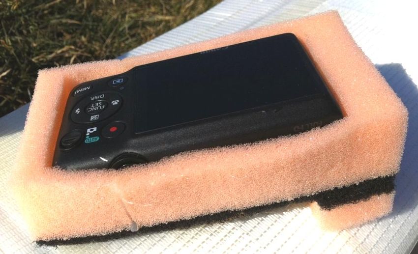
Mongabay.com Open Access Journal - Tropical Conservation Science Vol.5 (2):121-132, 2012

Missions
We conducted our test flights between 13 and 16 February, during which we flew 32 successful missions
with the drone. The main aim of these missions was to obtain photographs and videos on land use and
human activities within our study site. Here, we describe three of these missions (Fig. 4).
The first was a simple transect mission, in which the drone was programmed to fly at an altitude of 100
m above ground for a total distance of ~4 km, over an area that is known to be heavily degraded (Fig.
4a). The purpose of this mission was to demonstrate the use of the Conservation Drone for monitoring
human activities in and around forests.
We designed the second mission to be a grid of flight paths that covered ~50 ha (~10 km total flight
distance) of a predominantly forested landscape (Fig. 4b). For this mission, the drone was programmed
to fly at 180 m above ground, at a speed of 10 m s-1, and to take photographs every 10 seconds. These
flight characteristics ensured sufficient overlap (>50%) between photographs to allow for the creation of
a geo-referenced mosaic for subsequent spatial analysis (e.g., quantifying areas of different land uses).
The third was a river mission that followed a section of the Besitang river (Fig. 4c). The drone flew at 100
m above ground for a total distance of ~6 km. This mission demonstrates the use of the drone for
surveying river ecosystems.

The first and second missions were flown twice: once with the Canon or Pentax camera, and then with
the GoPro video camera. Photographs taken by the Canon and Pentax camera were subsequently geo-
tagged, using a freeware (Geosetter; geosetter.de), with information on geographical coordinates of
flight paths that were logged by the APM.

All photographs shown in the following sections were either taken by the authors or adapted from
GoogleEarth or from LandSat.

                                                               Fig. 4. Three test
                                                               missions flown by the
                                                               Conservation Drone. a)
                                                               simple transect mission;
                                                               b) grid mission; and c)
                                                               river mission.

           Tropical Conservation Science | ISSN 1940-0829 | Tropicalconservationscience.org
                                                  125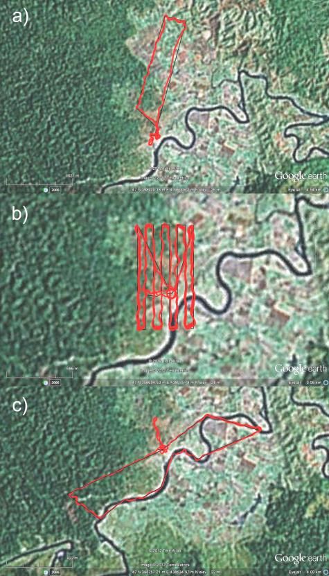
Mongabay.com Open Access Journal - Tropical Conservation Science Vol.5 (2):121-132, 2012

Results
Land use/ cover mapping
In the images acquired during our transect mission, we could easily distinguish different land uses,
including oil palm plantations (Fig. 5a), maize fields (Fig. 5b), human habitation (Fig. 5c), forests (Fig. 5d),
logged areas (Fig. 5e), and forest trails (Fig. 5f). These geo-tagged photographs and the flight paths of
each mission could also be superimposed on Google Earth (Fig. 6), which allows for easy visualization of
the location of features of interest from the photographs.
Using commercially available software (e.g., Autopano giga; kolor.com/), we produced geo-referenced
mosaics from these aerial photographs (e.g., Fig. 7). These mosaics are essentially near real-time land
use/ cover maps, which could be useful for local conservation workers seeking to monitor land-use
change and illegal forest activities. An example is the mosaic produced from our grid mission, which is
overlaid on a Landsat-based land use/ cover map (Fig. 7). The pixel resolution of our mosaic (5.1 cm) is
600 times higher than that of the Landsat-based map (30 m).

Human activity detection
Video footages acquired by Conservation Drones can complement still images and mosaics, particularly
for detecting ongoing human activities. In video footages recorded at relatively low altitudes (80-100 m
above ground), one could easily detect objects below the drone’s flight path, including individual forest
trees, oil palms, orangutans and elephants. When the drone was flying at 200 m above ground, activities
in the larger landscape could also be monitored, including fires and recent logging. For example, in the
video from the transect mission (youtu.be/IOm9v0Ewcek), one could clearly observe plumes of smoke
rising from several locations in the landscape. This information could facilitate more targeted
deployment of local rangers to patrol the problem areas.

                                                                            Fig. 5. Aerial photographs of land
                                                                            uses captured by the Conservation
                                                                            Drone. a) young oil palm plantation;
                                                                            b) maize field; c) human habitation:
                                                                            camp of the Elephant Patrol Unit in
                                                                            Aras Napal, Sumatra, Indonesia; d)
                                                                            forest; e) recently logged forest; and
                                                                            f) forest trail.

            Tropical Conservation Science | ISSN 1940-0829 | Tropicalconservationscience.org
                                                   126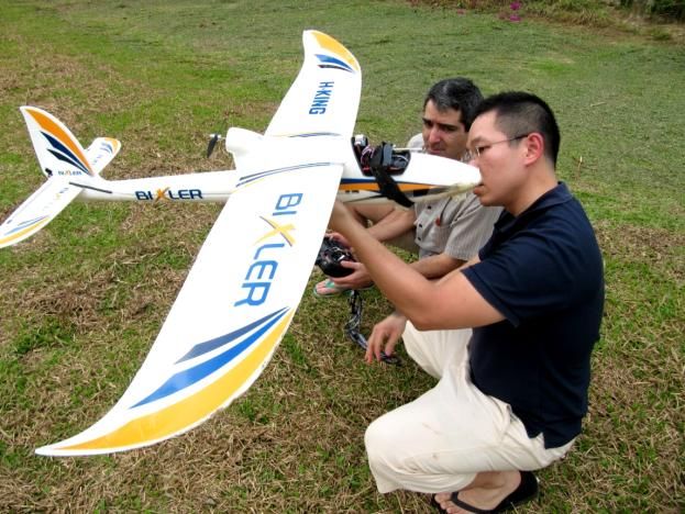
Mongabay.com Open Access Journal - Tropical Conservation Science Vol.5 (2):121-132, 2012
Biodiversity surveys
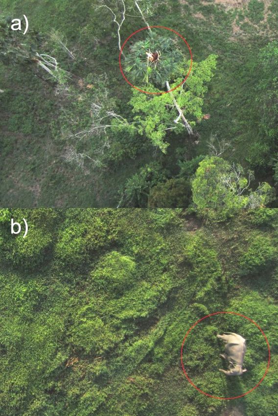
When equipped with a still-photograph camera, the Conservation Drone could document large
mammals. A wild Sumatran orangutan was photographed while it was on top of a palm tree feeding on
palm heart (Fig. 8a). A tame elephant was also clearly photographed, which illustrates how large wildlife
species could be surveyed with this technology (Fig. 8b). Currently, studies of wild elephant populations
often involve radio-collaring [12]. Based on the GPS telemetry data sent from these collars via satellite
link to a researcher, a Conservation Drone could be deployed to the current location of the animal to
acquire photographic and video information about its behavior, habitat and food resource utilization.
Although no specific attempts were made to identify flora during our test flights, the resolution of the
photographs is evidently sufficient to allow for identification of tree species based on canopy, fruit and
flower characteristics [13].
Fig. 6. Geo-referenced mosaic and
flight path of grid mission overlaid on
Landsat-based land use/ cover map.
Fig. 7.Placement of geo-tagged
photographs on Google Earth.
Tropical Conservation Science | ISSN 1940-0829 | Tropicalconservationscience.org
127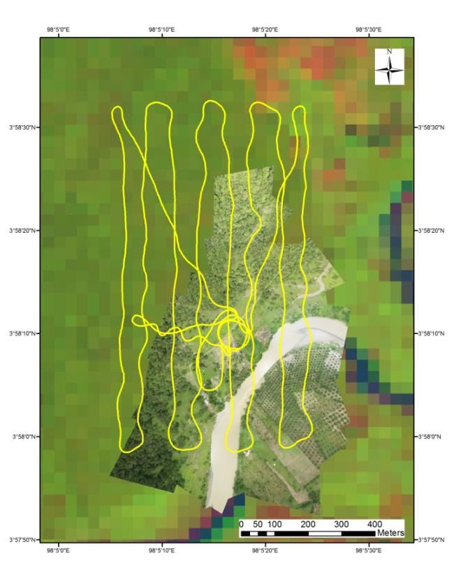
Mongabay.com Open Access Journal - Tropical Conservation Science Vol.5 (2):121-132, 2012

Discussion
Drone operation
A key consideration in developing Conservation Drones is their ease of use for non-specialist operators,
who would mainly include conservation workers and field ecologists. Our prototype system already
meets this criterion in most operating aspects, especially in the planning of each mission using the APM
Planner. Equally noteworthy is the ability of the drone to take off autonomously with a light toss by the
operator. Landing of the drone in a constrained space (20 km h-1), the drone did have a tendency to meander its way between waypoints,
instead of flying a straight path. Therefore, to ensure best outcomes, we recommend the drone be
operated only when wind speed is less than 10 km h-1.

                                                                     Fig. 8. Wildlife photographs
                                                                     captured by onboard camera. a)
                                                                     Sumatran orangutan; and b)
                                                                     Sumatran elephant.

           Tropical Conservation Science | ISSN 1940-0829 | Tropicalconservationscience.org
                                                  128
Mongabay.com Open Access Journal - Tropical Conservation Science Vol.5 (2):121-132, 2012

Photo and video quality
Several factors determine the resolution of aerial photographs taken by the drone, including flight
altitude, and the focal length and sensor size of the camera. The APM Planner includes a built-in
application that allows the user to calculate picture resolution based on camera and flight settings. To
illustrate a typical mission scenario, when flying 200 m above ground and at a camera focal length of 5.7
cm, we could capture images with a resolution of 5.3 cm per pixel, using either the Canon or Pentax
camera (which have the same sensor size) (Table 1).

                     Table 1. Examples of achievable picture resolution under different
                     combinations of camera and flight parameters.

              Focal Length (cm) Flight altitude (m, above ground) Picture resolution (cm)
                     4.1                        200                         7.4
                     4.1                        100                         3.7
                     5.7                        200                         5.3
                     5.7                        100                         2.7
                     6.9                        200                         4.4
                     6.9                        100                         2.2

To compensate for movement of the drone in flight, we recommend setting the camera for automatic
metering and focusing. Under this setting, our test photographs were taken at shutter speeds of
between f1/320 and f/1000, which effectively avoided motion blur. During flight, the electric motor of
the drone does produce vibrations which could result in vibration blur in photographs. As a solution, we
created a vibration dampening system using low density packing foam (Fig. 9). We later discovered that
the common kitchen sponge works equally well as a construction material. This instrument for Stable
Placement of ONboard Gear and Equipment (iSPONGE) successfully removes vibration blur.

Land use change and human activity detection
The photographs and videos obtained during our test missions demonstrate the utility of the
Conservation Drone for mapping and monitoring land use change. Larger crops, such as oil palm trees,
could easily be distinguished (Fig. 5a); even relatively small crops, such as maize stands (Fig. 5b), could be
identified from the photographs. The Conservation Drone can also acquire evidence of human activities
in the landscape, such as logging (Fig. 5e), forest trails (Fig. 5f), and forest fires (youtu.be/IOm9v0Ewcek).
Therefore, the drone could also facilitate enforcement of protected areas, particularly where constraints
in conservation resources have led to forest encroaching and illegal forest activities [14]. Furthermore,
owing to the negligible cost of operating the drone, target areas could be repeatedly surveyed at high
frequency to monitor potential land use changes and activities.
However, we do recognize that a common problem of mosaic creation is the difficulty of stitching
together photographs solely of forests. For example, the mosaic for our grid mission excludes substantial
portions of forest in the northwestern part of the grid (Fig. 7). This problem arises because when flying at
relatively low altitudes, the same emergent tree captured from different perspectives in different images
was interpreted to be different trees by the stitching software. This results in the failure of the software
to detect common features in a series of photographs, which is crucial for mosaic creation. The solution

           Tropical Conservation Science | ISSN 1940-0829 | Tropicalconservationscience.org
                                                  129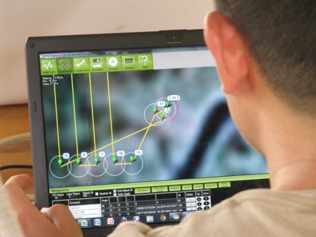
Mongabay.com Open Access Journal - Tropical Conservation Science Vol.5 (2):121-132, 2012

is to fly the drone at higher altitudes (e.g., 300 m above ground) to minimize such perspective
discrepancies; the camera focal length could be increased to maintain picture resolution.
Another potential application of the drone is for ground truthing. Conventional methods of classifying
land use/ cover from satellite data requires ground truthing to assess the accuracy and reliability of
classification outcomes. Given that the deployment of local workers for ground truthing is often costly in
terms of time and financial resources (and practically impossible in the most remote and inaccessible
areas), ground truthing is often only carried out for a very limited extent of the area being classified. In
principle, Conservation Drones could be used for ‘drone truthing’ of satellite-based land use
classification, since drones could be deployed more quickly and over larger distances than local
researchers on the ground.

                                                              Fig. 9. The instrument for Stable Placement of
                                                              ONboard Gear and Equipment (iSPONGE), which is
                                                              installed in the Conservation Drone to avoid
                                                              vibration blur in photographs.

Biodiversity surveys in other ecosystems
Both the photographic and video data obtained during our test missions were of sufficient quality to
identify large animals such as orangutans (and their nests in tree canopies) and elephants. In principle,
Conservation Drones could also be used in other ecosystems, particularly open habitat types such as
woodlands or savannas. In those systems, Conservation Drones could obtain valuable information on
wildlife abundance, distribution, as well as habitat and resource utilization. Drones could also potentially
be used for surveying marine animals, such as turtles (based on their tracks on beaches), as well as
dugongs in shallow waters.

Comparison with other drone systems
We are developing Conservation Drones as a low-cost alternative to commercially available unmanned
aerial vehicles that have been used by the military, agriculture sector, and the film industry. Some
ecologists have also started using commercial systems for surveying wildlife [15-18]. However,
commercial drones can cost tens of thousands of dollars . For example, a commercially-produced
prototype system for wildlife research in Florida cost $35,000 [17]. The quality of data acquired by
Conservation Drones is comparable to some of these commercial systems (e.g., sensefly.com).
Furthermore, commercial systems often have an integrated photographic camera, but not a video
camera. Therefore, not only are Conservation Drones orders of magnitude less expensive, but they also
allow for much greater flexibility in terms of the sensor system they can carry.
Another key advantage of Conservation Drones over commercial systems stems from the fact that
Conservation Drones are based on hardware and software that are being developed by an open-source

           Tropical Conservation Science | ISSN 1940-0829 | Tropicalconservationscience.org
                                                  130
Mongabay.com Open Access Journal - Tropical Conservation Science Vol.5 (2):121-132, 2012
community. Therefore, as users demand and contribute new features and functionalities, this technology
will continue to improve. This communal and crowdsourcing approach is highly efficient and cost
effective compared to product development by any single research team. At the same time, the cost of
producing Conservation Drones likely will decrease with the cost of its components, such as lithium-
polymer batteries.
Fig. 10. Conservation Drone 2.0 that is under
development and testing.
Future development and conclusion
We are currently building upon the success of our prototype system to develop Conservation Drone 2.0
(Fig. 10). Two key improvements we seek are a bigger payload and longer range. Conservation Drone 2.0
is based on another popular remote control model airplane (FPV Raptor), which has a 2 m wingspan, 50%
larger than our prototype drone. Initial tests suggest that the new drone can carry a 5000 mAh battery,
which could potentially increase its flight time and range to ~50 minutes and ~25 km, respectively.
We are also experimenting with the use of near infra-red, infra-red and ultra-violet cameras on
Conservation Drone 2.0. These sensors could potentially facilitate automated land use/ cover
classification from aerial photographs, as well as identification of warm-bodied wildlife and humans
when flying at dusk or dawn.
The use of Conservation Drones could lead to significant savings in terms of time, manpower and
financial resources for local conservation workers and researchers, which would increase the efficiency
of monitoring and surveying forests and wildlife in the developing tropics. We believe that Conservation
Drones could be a game-changer and might soon become a standard technique in conservation efforts
and research in the tropics and elsewhere.
Acknowledgements
We thank the Leuser International Foundation for granting us permission to work in the area and using
their facilities at the study site. In particular we thank A. Burhan, C. Cheng and S. Talaparu for their
logistical support and technical assistance. This project is partly supported by the National Geographic
Society, the Orangutan Conservancy, the Denver Zoo, the Philadelphia Zoo and the Swiss National
Science Foundation.
Tropical Conservation Science | ISSN 1940-0829 | Tropicalconservationscience.org
131Mongabay.com Open Access Journal - Tropical Conservation Science Vol.5 (2):121-132, 2012
References
[1] Baccini, A., et al. 2012 Estimated carbon dioxide emissions from tropical deforestation improved by
carbon-density maps. Nature Clim. Change in press.
[2] Koh, L. P., Miettinen, J., Liew, S. C. and Ghazoul, J. 2011 Remotely sensed evidence of tropical
peatland conversion to oil palm. Proc. Natl. Acad. Sci. USA 108:5127-5132.
[3] Koh, L. P. and Wilcove, D. S. 2008 Is oil palm agriculture really destroying tropical biodiversity?
Conserv Lett 1:60-64.
[4] Hardus, M. E., Lameira, A. R., Menken, S. B. J. and Wich, S. A. 2012 Effects of logging on orangutan
behavior. Biol. Conserv. 146:177-187.
[5] Broich, M., et al. 2011 Time-series analysis of multi-resolution optical imagery for quantifying forest
cover loss in Sumatra and Kalimantan, Indonesia. International Journal of Applied Earth Observation
and Geoinformation 13:277-291.
[6] Hansen, M. C., et al. 2008 A method for integrating MODIS and Landsat data for systematic
monitoring of forest cover and change in the Congo Basin. Remote Sens. Environ. 112:2495-2513.
[7] Gardner, T. A., et al. 2008 The cost-effectiveness of biodiversity surveys in tropical forests. Ecol. Lett.
11:139-150.
[8] Meijaard, E., Wich, S., Ancrenaz, M. and Marshall, A. J. 2012 Not by science alone: why orangutan
conservationists must think outside the box. Ann. N. Y. Acad. Sci. 1249:29-44.
[9] Palace, M., Keller, M., Asner, G. P., Hagen, S. and Braswell, B. 2008 Amazon Forest Structure from
IKONOS Satellite Data and the Automated Characterization of Forest Canopy Properties. Biotropica
40:141-150.
[10]Abdulhadi, R., Mirmanto, E. and Kartawinata, K. 1987 A lowland dipterocarp forest in Sekundur,
North Sumatra, Indonesia: five years after mechanized logging. Proceedings of the Third Round Table
Conference on Dipterocarps, ed Kostermans AJGH), pp 255-273.
[11]Wich, S. A., et al. 2008 Distribution and conservation status of the orang-utan (Pongo spp.) on
Borneo and Sumatra: how many remain? Oryx:329-339.
[12]Campos-Arceiz, A., et al. 2008 Behavior rather than diet mediates seasonal differences in seed
dispersal by Asian elephants. Ecology 89:2684-2691.
[13]Getzin, S., Wiegand, K. and Schöning, I. 2012 Assessing biodiversity in forests using very high-
resolution images and unmanned aerial vehicles. Methods in Ecology and Evolution 3:397-404.
[14]Barrett, M. A., Brown, J. L., Morikawa, M. K., Labat, J.-N. and Yoder, A. D. 2010 CITES Designation for
Endangered Rosewood in Madagascar. Science 328:1109-1110.
[15]Sarda-Palomera, F., et al. 2012 Fine-scale bird monitoring from light unmanned aircraft systems. Ibis
154:177-183.
[16]Koski, W. R., et al. 2009 Evaluation of an unmanned airborne system for monitoring marine
mammals. Aquat. Mamm. 35:347-357.
[17]Jones IV, G. P., Pearlstine, L. G. and Percival, H. F. 2006 An assessment of small unmanned aerial
vehicles for wildlife research. Wildl. Soc. Bull. 34:750-758.
[18]Watts, A. C., et al. 2010 Small Unmanned Aircraft Systems for Low-Altitude Aerial Surveys. The
Journal of Wildlife Management 74:1614-1619.
Tropical Conservation Science | ISSN 1940-0829 | Tropicalconservationscience.org
132You can also read