Geological Field - Geological Field Trips and Maps
←
→
Page content transcription
If your browser does not render page correctly, please read the page content below
Geological Field
                                                                                                                                        Trips
                                                                                                                                                                    and
        Società Geologica
           Italiana                                                                                                                                                Maps
                                                                                                                                                                            2018
                                                                                                                                                                    Vol. 10 (1.1)
                     ISPRA
                              Dipartimento per il
SERVIZIO GEOLOGICO D’ITALIA
Organo Cartografico dello Stato (legge n°68 del 2-2-1960)

                                                                                                                                                                                     publishing group
                                                                                                                                                                   ISSN: 2038-4947

                                                             Past to present deformation of the central-eastern Southern Alps:
                                                                          from the foreland to the Giudicarie belt
                                                            2017 Annual Meeting of the Structural Geology Italian Group (GIGS) of the Italian Geological Society
                                                                                                  DOI: 10.3301/GFT.2018.01

   DOI: 10.3301/GFT.2018.01
Past to present deformation of the central-eastern Southern Alps: from the foreland to the Giudicarie belt
                                                  A. Viganò - D. Zampieri - S. Rossato - S. Martin - L. Selli - G.Prosser - S. Ivy-Ochs - P. Campedel - F. Fedrizzi - M. Franceschi - M. Rigo

    GFT&M - Geological Field Trips and Maps

                                                                                                                                                                                                 geological field trips and maps 2018 - 10(1.1)
                                  Periodico semestrale del Servizio Geologico d’Italia - ISPRA e della Società Geologica Italiana
                                    Geol. F. Trips Maps, Vol.10 No.1.1 (2018), 78 pp., 71 Figs. (DOI 10.3301/GFT.2018.01)

                               Past to present deformation of the central-eastern Southern Alps:
                                            from the foreland to the Giudicarie belt
               2017 Annual Meeting of the Structural Geology Italian Group (GIGS) of the Italian Geological Society
     Alfio Viganò1, Dario Zampieri2, Sandro Rossato2, Silvana Martin2, Luigi Selli3, Giacomo Prosser4, Susan Ivy-Ochs5,
                            Paolo Campedel1, Fabio Fedrizzi1, Marco Franceschi2, Manuel Rigo2
1
    Servizio Geologico, Provincia Autonoma di Trento, Via Zambra 42, 38121 Trento
2
    Dipartimento di Geoscienze, Università degli Studi di Padova, Via Gradenigo 6, 35131 Padova
3
    Dipartimento di Scienze Biologiche, Geologiche e Ambientali, Università degli Studi di Bologna, Piazza di Porta San Donato 1, 40136 Bologna
4
    Dipartimento di Scienze, Università degli Studi della Basilicata, Viale dell’Ateneo Lucano 10, 85100 Potenza
5
    Department of Earth Sciences, ETH Zürich, Sonneggstrasse 5, 8092 Zürich

Corresponding Author e-mail address: alfio.vigano@provincia.tn.it

Responsible Director
Claudio Campobasso (ISPRA-Roma)
Editor in Chief                                                                                                                     Editorial Advisory Board                                        2
Andrea Zanchi (Università di Milano-Bicocca)
                                                                                                                                    D. Bernoulli, F. Calamita, W. Cavazza,
Editorial Manager                                                                                                                   F.L. Chiocci, R. Compagnoni,
Mauro Roma (ISPRA-Roma) - corresponding manager                                                                                     D. Cosentino, S. Critelli, G.V. Dal Piaz,
Silvana Falcetti (ISPRA-Roma), Fabio Massimo Petti (Società Geologica Italiana - Roma),                                             P. Di Stefano, C. Doglioni, E. Erba,
Maria Luisa Vatovec (ISPRA-Roma), Alessandro Zuccari (Società Geologica Italiana - Roma)

                                                                                                                                                                                                publishing group
                                                                                                                                    R. Fantoni, M. Marino, M. Mellini,
Associate Editors                                                                                                                   S. Milli, E. Chiarini, V. Pascucci,
M. Berti (Università di Bologna), M. Della Seta (Sapienza Università di Roma),                                                      L. Passeri, A. Peccerillo, L. Pomar,
P. Gianolla (Università di Ferrara), G. Giordano (Università Roma Tre), M. Massironi                                                P. Ronchi, B.C. Schreiber, L. Simone,
(Università di Padova), M.L. Pampaloni (ISPRA–Roma), M. Pantaloni (ISPRA-Roma),                                                     I. Spalla, L.H. Tanner, C. Venturini,
M. Scambelluri (Università di Genova), S. Tavani (Università di Napoli Federico II)                                                 G. Zuffa.

                                                                     ISSN: 2038-4947 [online]

                                                                        http://gftm.socgeol.it/
The Geological Survey of Italy, the Società Geologica Italiana and the Editorial group are not responsible for the ideas, opinions and contents of the guides
published; the Authors of each paper are responsible for the ideas, opinions and contents published.
Il Servizio Geologico d’Italia, la Società Geologica Italiana e il Gruppo editoriale non sono responsabili delle opinioni espresse e delle affermazioni
pubblicate nella guida; l’Autore/i è/sono il/i solo/i responsabile/i.
    DOI: 10.3301/GFT.2018.01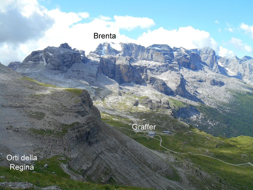
Past to present deformation of the central-eastern Southern Alps: from the foreland to the Giudicarie belt
                                                   A. Viganò - D. Zampieri - S. Rossato - S. Martin - L. Selli - G.Prosser - S. Ivy-Ochs - P. Campedel - F. Fedrizzi - M. Franceschi - M. Rigo

                                                                                                                                                                                                 geological field trips and maps 2018 - 10(1.1)
INDEX

Information

Abstract........................................................................ 4            STOP 1.6: The Castelpietra and Lavini di Marco
Program summary.......................................................... 4                   rock-avalanches in the Adige Valley: ages and earthquake
Safety........................................................................... 7           triggering.................................................................... 36
Hospitals....................................................................... 7            Stop 1.6.1: Castelpietra................................................ 37
Accommodation............................................................. 8                  Stop 1.6.2: Lavini di Marco............................................ 38
                                                                                              STOP 1.7: The Marocche di Dro rock-avalanches
Excursion notes                                                                               in the Sarca Valley: revisiting a reference case study ........ 43

1. Geology and seismotectonics                                                                DAY 2: Geology and structures of the central Brenta                                                  3
of the central-eastern Southern Alps........................... 9                             Dolomites.................................................................. 53
2. Geology of the Brenta Dolomites........................... 13                              STOP 2.1: Tectonics around Grostè Pass......................... 53
                                                                                              Stop 2.1.1: ................................................................. 54
                                                                                              Stop 2.1.2: The Pietra Grande thrust .............................. 56
Itinerary                                                                                     STOP 2.2: Panoramic view of the Adamello-Presanella
Day 1: Geology and tectonics of the Astico Valley                                             and Cevedale Massifs.................................................... 56
and southern Trentino: faults, rock-avalanches                                                STOP 2.3: The puzzle of the Monte Spinale klippe
and seismicity........................................................... 17                  and its Quaternary evolution.......................................... 63
STOP 1.1: The Southern Alps frontal belt and                                                  Stop 2.3.1: Thick palaeosoils......................................... 68
geomorphology of the Astico frontal moraine system ........ 17                                Stop 2.3.2: The dragged Monte Spinale breccias in the
STOP 1.2: La Marogna landslide: a structurally                                                Vedretta dei Camosci fault hanging-wall.......................... 69
controlled collapse ....................................................... 23                Stop 2.3.3: Scaglia Rossa megablocks in the Monte

                                                                                                                                                                                                 index
STOP 1.3: The Jurassic faults across the Vicentinean                                          Spinale breccias........................................................... 69
plateaux ..................................................................... 24             Stop 2.3.4: The Monte Spinale thrust ............................. 70
STOP 1.4: The Cornetto-Becco di Filadonna pop-up ......... 27
STOP 1.5: Fault rocks at Fricca Pass .............................. 31                        References................................................................ 74

 DOI: 10.3301/GFT.2018.01
Past to present deformation of the central-eastern Southern Alps: from the foreland to the Giudicarie belt
                                    A. Viganò - D. Zampieri - S. Rossato - S. Martin - L. Selli - G.Prosser - S. Ivy-Ochs - P. Campedel - F. Fedrizzi - M. Franceschi - M. Rigo

Abstract

                                                                                                                                                                                  geological field trips and maps 2018 - 10(1.1)
A field trip across the central-eastern sector of the Southern Alps, from the foreland to the Giudicarie fold-and-
thrust belt, is here described. The field trip, which was held on 12-13 July 2017, followed the Annual Meeting
of the Gruppo Italiano di Geologia Strutturale (GIGS) of the Italian Geological Society. It was organized by
the Geoscience Department of the University of Padova as a 2-day itinerary in Veneto and Trentino. This
guide provides a geological overview of the main structural domains of the central-eastern Southern Alps
(the Giudicarie and Schio-Vicenza domains) and focuses on evidence of past and present brittle deformation,
principally within carbonate rocks of Late Triassic to Early Cretaceous age. The itinerary and Stop descriptions
are particularly devoted to observation and discussion of exhumed faults, present and past seismicity, large
landslides/rock avalanches of Holocene to historic age, and their interactions. The observation of specific
outcrops is also combined with spectacular panoramas illustrating the regional tectonic setting of the Southern
Alps and of the nearby Austroalpine units.

Key words: Structural geology, faults, rock-avalanches, historical seismicity, seismic faulting, Southern Alps,
Veneto, Trentino.
                                                                                                                                                                                    4
Program summary

During the first day of the field trip, the geological evidence of brittle tectonics and active deformation (exposed
faults; large landslides/rock avalanches, with structural control and in some cases triggered by earthquakes)
in the central-eastern Southern Alps is shown and discussed. The second day focuses on the geology of the
central Brenta Massif and related tectonics.

                                                                                                                                                                                  information
Here below a brief description of the field trip and related stop points (see Fig. 1 for the first day and Fig. 2 for
the second day).

DAY 1 – “Geology and tectonics of the Astico Valley and southern Trentino: faults, rock-avalanches and seismicity”
The field trip starts at Piovene Rocchette north of Vicenza (STOP 1.1), approaching the Southern Alps front
nearly where the Bassano thrust (one of the seismogenic sources of the ENE-WSW active front of the eastern
Southern Alps; DISS Working Group, 2018) reaches the surface. Here we can observe the Last Glacial Maximum
DOI: 10.3301/GFT.2018.01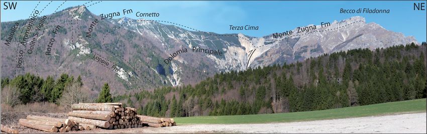
Past to present deformation of the central-eastern Southern Alps: from the foreland to the Giudicarie belt
                                    A. Viganò - D. Zampieri - S. Rossato - S. Martin - L. Selli - G.Prosser - S. Ivy-Ochs - P. Campedel - F. Fedrizzi - M. Franceschi - M. Rigo

(LGM) alluvial fans of the Astico river and, continuing to the north along the Astico Valley, the present river

                                                                                                                                                                                  geological field trips and maps 2018 - 10(1.1)
incision in the Mesozoic bedrock (hanging-wall of the Bassano thrust).
The middle Astico Valley is today partly infilled with a large landslide deposit (La Marogna, STOP 1.2), which is
being actively quarried. The La Marogna principal slip surface of failure is a fault plane (thrust with 35° dip towards
the valley), which can be also observed at the base of the main scarp (Zampieri and Adami, 2013). The deposit
is historical in age (14C dating, Barbieri and Grandesso, 2007) and correlates with other earthquake-triggered
landslides of similar age in the Adige Valley (Ivy-Ochs et al., 2017a; 2017b; see STOP 1.6 and STOP 1.7).
Along the upper Astico Valley near Lastebasse (STOP 1.3), N-S-trending Jurassic synsedimentary faults are
visible (Lavarone plateau) (Zampieri and Massironi, 2007).
STOP 1.4 and STOP 1.5 are both related to the Cornetto di Folgaria-Becco di Filadonna pop-up, which is due to
the transpressional reactivation of a western lateral ramp (Calisio fault) of the Valsugana fault and the (possibly
Jurassic) Centa fault (Zampieri et al., 2003). All these faults, which are also seismotectonically active in depth
(Viganò et al., 2015), have produced a prominent morphology and local slope instabilities. At the Fricca Pass
(STOP 1.5) we can also directly observe the damage zone of the Centa fault, with several discrete slip planes
with associated gouge.
After the descent in the Adige Valley, we can observe the Castelpietra landslide (Stop 1.6.1) and the Lavini
                                                                                                                        5
di Marco rock avalanche (Stop 1.6.2). Both are described and discussed, in terms of geology (lithologies,
structures), geomorphology (deposit shape, volume and characters) and age (Martin et al., 2014; Ivy-Ochs et
al., 2017a). Particular attention is deserved on the triggering mechanisms, also in relation with historical and
present seismicity (Ivy-Ochs et al., 2017a; 2017b).
The itinerary then moves to the west, in the lower Sarca Valley, entering the Giudicarie fault system (Jurassic
to Cenozoic geological formations, with volcanics of the Venetian Paleogene magmatism). In this area, NW-SE
oriented nearly vertical strike-slip faults, belonging to the Schio-Vicenza system, cut across the Giudicarie faults

                                                                                                                                                                                  information
dislocating originally adjacent structural blocks. North of Dro we observe the Marocche di Dro rock avalanches,
some of the most famous and most beautiful of Alpine rock avalanche deposits (STOP 1.7). These deposits are
subdivided in two main rock avalanche bodies: the Marocca Principale to the north (1000 X 106 m3 volume)
and the Kas to the south (300 X 106 m3 volume) (Ivy-Ochs et al., 2017b). The age of Marocca Principale (5300
± 860 yr ago) suggests occurrence during a known period of enhanced slope instability in the Alps, possibly
related to the shift to wetter, colder climate conditions at the transition from the middle to the late Holocene.
Conversely, the age of Kas (1080 ± 160 yr ago) implies an earthquake as trigger, and specifically the “Middle
DOI: 10.3301/GFT.2018.01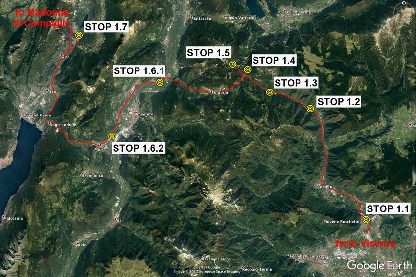
Past to present deformation of the central-eastern Southern Alps: from the foreland to the Giudicarie belt
                                    A. Viganò - D. Zampieri - S. Rossato - S. Martin - L. Selli - G.Prosser - S. Ivy-Ochs - P. Campedel - F. Fedrizzi - M. Franceschi - M. Rigo

Adige Valley” 1046 AD earthquake

                                                                                                                                                                                  geological field trips and maps 2018 - 10(1.1)
(36Cl exposure dating by Ivy-Ochs
                                                                     STOP 1.7
et al., 2017b).
After this last stop for the day, we                                                                  STOP 1.5
go across the Giudicarie Valley to                                                                                         STOP 1.4
                                                                               STOP 1.6.1
Tione di Trento and Madonna di
                                                                                                                                  STOP 1.3
Campiglio in the Rendena Valley.
During this trip we can observe the                                                                                                             STOP 1.2
Southalpine basement (Rendena
schists) intruded by Permian
granitoids (Caderzone and Doss                                                STOP 1.6.2
del Sabion granodiorites), and
the Cenozoic Adamello tonalite.
Along the road between Carisolo
and Sant’Antonio di Mavignola, the                                                                                                                             STOP 1.1
strongly foliated Central Presanella
                                                                                                                                                                                    6
tonalite is clearly crosscut by the
South Giudicarie fault.

DAY 2 - “Geology and structures
of the central Brenta Dolomites”       Fig. 1 - Itinerary of the field trip first day (base map from Google Earth).
During the second day of the field
trip three stops are planned in the

                                                                                                                                                                                  information
Brenta Massif (Grostè, Pietra Grande and Monte Spinale). The first one is at the Grostè Pass (Stop 2.1.1), reached
by the cableway, with the geological introduction of the area. After a one-hour walk (“Vidi” protected climbing
path) the Pietra Grande thrust is reached (Stop 2.1.2). Soon after, a grassy terrace allows for a panoramic view
of the surrounding mountains belonging to the Adamello-Presanella and Cevedale massifs (STOP 2.2).
At Monte Spinale (STOP 2.3) the limestones of the Calcare di Zu override the carbonates of the Calcari Grigi
Group (Monte Spinale klippe), as similarly observed for the Pietra Grande klippe and the Cima di Val Scura
klippe (to the NE). The Monte Spinale thrust shows successive west-vergent reactivations, which deform also
DOI: 10.3301/GFT.2018.01
Past to present deformation of the central-eastern Southern Alps: from the foreland to the Giudicarie belt
                                    A. Viganò - D. Zampieri - S. Rossato - S. Martin - L. Selli - G.Prosser - S. Ivy-Ochs - P. Campedel - F. Fedrizzi - M. Franceschi - M. Rigo

the Monte Spinale breccias. Even if

                                                                                                                                                                                  geological field trips and maps 2018 - 10(1.1)
their interpretation is still debated,
they most probably represent fine-
matrix rich stratified gravitational
fluxes emplaced from the east
(Grostè area).

Safety                                                                                                                   STOP 2.2
                                                                                                                                                     STOP 2.1.2
The field trip goes through rough
mountain terrains and reaches
                                                                                             STOP 2.3.4
heights of about 2600 meters.
Therefore,     adequate    technical
personal equipment is required,
                                                                                                                    STOP 2.3.1
especially for the “Vidi” protected                                            STOP 2.3.3
climbing path (Stops 2.1.2 and 2.2).                                                                            STOP 2.3.2
                                                                                                                                                             STOP 2.1.1             7
The best seasons for the visit are
summer and autumn, with absence
of snow cover. Avoid scheduling the
visit after days of heavy rain.
                                             Fig. 2 - Itinerary of the field trip second day (base map from Google Earth).
Useful phone numbers:
Fire Fighters – 115 – Vigili del Fuoco

                                                                                                                                                                                  information
Police – 113 – Polizia

Hospitals

Santorso (Vicenza) – Ospedale Alto Vicentino, Via Garziere 42, 36014 Santorso - Tel. 0445 571111
Trento – Ospedale Santa Chiara, Largo Medaglie d’Oro 9, 38122 Trento - Tel. 0461 903111
Rovereto – Ospedale S. Maria del Carmine, Corso Verona 4, 38068 Rovereto - Tel. 0464 403111
DOI: 10.3301/GFT.2018.01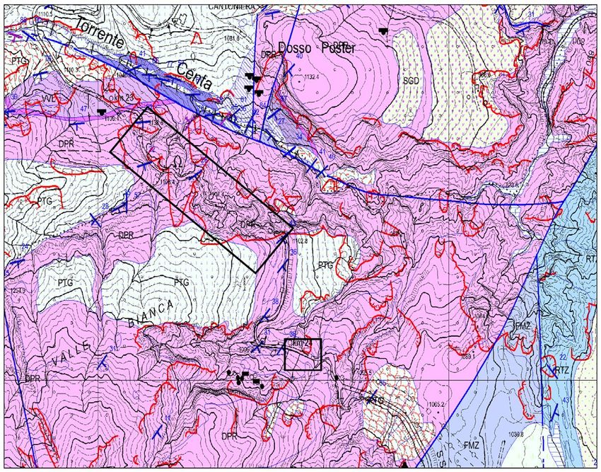
Past to present deformation of the central-eastern Southern Alps: from the foreland to the Giudicarie belt
                                    A. Viganò - D. Zampieri - S. Rossato - S. Martin - L. Selli - G.Prosser - S. Ivy-Ochs - P. Campedel - F. Fedrizzi - M. Franceschi - M. Rigo

Arco – Ospedale Civico, Via dei Capitelli 48, 38062 Arco - Tel. 0464 582222

                                                                                                                                                                                  geological field trips and maps 2018 - 10(1.1)
Tione di Trento – Ospedale, Via Ospedale 11, 38079 Tione di Trento - Tel. 0465 331111

Other phone numbers:
Emergency – 112 – Emergenza (the only one emergency number in Trentino)
Ambulance – 118 – Ambulanza

Accommodation

Azienda per il turismo Trento, Monte Bondone, Valle dei Laghi, http://www.discovertrento.it
Trentino Marketing, https://www.visittrentino.info/it

Other phone numbers:
Servizio Geologico, Protezione Civile della Provincia Autonoma di Trento, www.protezionecivile.tn.it,
Tel. 0461 495200
Parco Naturale Adamello-Brenta, www.pnab.it, Tel. 0465 806666
                                                                                                      8
MuSE – Museo delle Scienze, www.muse.it, Tel. 0461 270311
SAT – Società degli Alpinisti Tridentini, www.sat.tn.it, Tel. 0461 981871

                                                                                                                                                                                  information
DOI: 10.3301/GFT.2018.01
Past to present deformation of the central-eastern Southern Alps: from the foreland to the Giudicarie belt
                                    A. Viganò - D. Zampieri - S. Rossato - S. Martin - L. Selli - G.Prosser - S. Ivy-Ochs - P. Campedel - F. Fedrizzi - M. Franceschi - M. Rigo

The following introductory instruction notes are organized in two different sections. The first section is a general

                                                                                                                                                                                  geological field trips and maps 2018 - 10(1.1)
overview on geology and seismotectonics of the central-eastern sector of the Southern Alps. The second section
is a specific focus on the geology of the Brenta Dolomites, a relatively small area within the central-eastern
Southern Alps, and it represents the specific introduction of the second-day field trip.

1. Geology and seismotectonics of the central-eastern Southern Alps

The central-eastern Southern Alps are one of the most active areas of the Alpine belt where seismicity is
related to deformation along the western margin of the Adriatic indenter (Slejko et al., 1989; Viganò et al.,
2008; 2015). Deep seismic soundings show a complex structure of the Adriatic crust with local fragmentation
and lower crust wedges, as similarly observed for upper crustal strong heterogeneities by local earthquake
tomography (Viganò et al., 2013a). At the lithospheric scale, seismic tomography suggests an abrupt change of
polarity of subduction along the Giudicarie realm (Europe subduction in the Western Alps vs. Adria subduction
in the Eastern Alps; Kissling et al., 2006 and references therein).
Stratigraphy extends from pre-Permian metamorphic basements of the Austroalpine and Southalpine domains
to Pliocene-Quaternary rocks in the Po and Venetian plains. Sedimentary covers of mainly carbonate sequences
                                                                                                                  9
of Middle Triassic-Jurassic age extensively outcrop south of the Insubric Line, with variable lateral thicknesses
between the so-called reduced Trento platform and the Lombardian Basin to the west and the Belluno Basin to
the east (Doglioni and Bosellini, 1987; Picotti et al., 1995; Castellarin et al., 2006). Large magmatic bodies of
Permian, Triassic, and Cenozoic age intrude the upper crust (Fig. 3).
The intricate fault pattern of the Southern Alps is the result of a polyphase deformation history since the Late

                                                                                                                                                                                  excursion notes
Permian (Doglioni and Bosellini, 1987; Castellarin et al., 2006; Pola et al., 2014; Franceschi et al., 2014a)
resulting in four main tectonic systems: the N-S Early Jurassic extensional fragmentation of the Trento platform,
the ENE-WSW compressive Valsugana, the NNE-SSW transpressive Giudicarie, and the NW-SE strike-slip Schio-
Vicenza fault systems (Fig. 3). In particular, two main compressive tectonic events accommodated deformation
during the Neogene, by contraction and oblique inversion of the Mesozoic passive margin of the Adria plate: (i)
along the Giudicarie fold-and-thrust belt and the Valsugana system (Middle-Late Miocene event), and (ii) along
the Bassano del Grappa-Montello thrusts (Late Miocene-Pliocene event; Castellarin et al., 2006).
The eastern Southern Alps are a SSE-vergent mountain belt arranged in an imbricate fan of ca. ENE-WSW thrust
sheets involving the crystalline basement (Fig. 3). In plan view, the thrusts show several undulations controlled
DOI: 10.3301/GFT.2018.01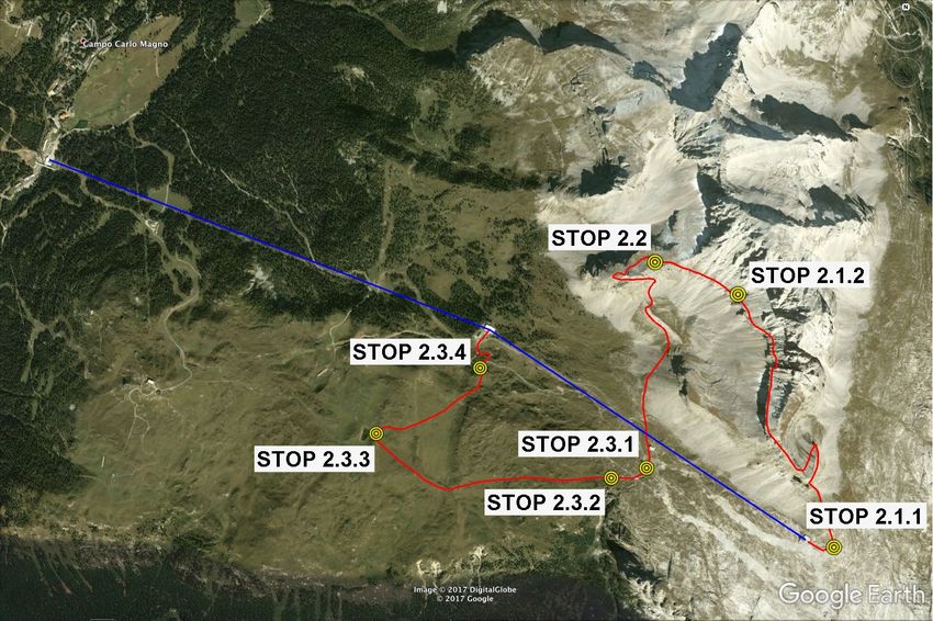
Past to present deformation of the central-eastern Southern Alps: from the foreland to the Giudicarie belt
                                            A. Viganò - D. Zampieri - S. Rossato - S. Martin - L. Selli - G.Prosser - S. Ivy-Ochs - P. Campedel - F. Fedrizzi - M. Franceschi - M. Rigo

                                                                                                                                                                                          geological field trips and maps 2018 - 10(1.1)
                                                                                                                                                                                          10

                                                                                                                                                                                          excursion notes
                    Fig. 3 - Geological map of the central-eastern Alps. In the sketch, the complex structural patterns at the
                  junction of the three regional fault systems (Valsugana, Giudicarie and Schio-Vicenza). (Reprinted from
                  Tectonophysics, 661, Viganò et al., Earthquake relocations, crustal rheology, and active deformation in the
                   central-eastern Alps (N Italy), 81-98, Copyright (2015), with permission of Elsevier).
DOI: 10.3301/GFT.2018.01
Past to present deformation of the central-eastern Southern Alps: from the foreland to the Giudicarie belt
A. Viganò - D. Zampieri - S. Rossato - S. Martin - L. Selli - G.Prosser - S. Ivy-Ochs - P. Campedel - F. Fedrizzi - M. Franceschi - M. Rigo
by inherited features, such as N-S to NNE-
geological field trips and maps 2018 - 10(1.1)
SSW Norian-Early Cretaceous normal faults
and, in the western Veneto Region, NNW-
SSE Paleogene normal faults. Crossing
the Prealps from the southern foreland
towards the north, west of the Adige
Valley the Neogene structures trend NNE-
SSW (Giudicarie belt), due to the sinistral
transpression of the tectonically controlled
western margin of the Trento carbonate
platform (Fig. 3). In particular, the
Giudicarie belt is a first-order deformation
fault zone where Mesozoic extensional
faults were inverted into compression
systems, mostly during the Neogene, with
important structural interactions with the
11
Valsugana and the Schio-Vicenza faults
(Castellarin et al., 2006).
The whole area shows relevant historical
and instrumental seismicity; the proposed
present-day seismotectonic model is
excursion notes
based on earthquake distributions,
focal mechanisms, and other geological
constraints (Figs. 4 and 5) (Viganò et
al., 2015). This seismotectonic model
shows (dominant) compression along the
Giudicarie and Belluno-Bassano-Montello
Fig. 4 - Instrumental seismicity distribution in the period 1994-2015, fronts, with strain partitioning along
classified by local magnitude (courtesy of the Trentino seismic network of dominant right-lateral strike-slip faults
the Autonomous Province of Trento). in the middle zone (Fig. 5). The present-
DOI: 10.3301/GFT.2018.01Past to present deformation of the central-eastern Southern Alps: from the foreland to the Giudicarie belt
A. Viganò - D. Zampieri - S. Rossato - S. Martin - L. Selli - G.Prosser - S. Ivy-Ochs - P. Campedel - F. Fedrizzi - M. Franceschi - M. Rigo
geological field trips and maps 2018 - 10(1.1)
Fig. 5 - Seismotectonic model for the central-
eastern Alps (Viganò et al., 2015). Grey stars
are most relevant historical earthquakes after
the Parametric Catalogue of Italian Earthquakes
(CPTI15; Rovida et al., 2016), where Roman
numbers are calculated epicentral intensities.
Diamonds show the locations of geological
sites where Quaternary fault activity along
the Southalpine boundary is observed (grey
diamonds for compressional tectonics; white
diamonds for strike-slip and normal faults).
Fault abbreviations are: BA, Bassano; BG,
Ballino-Garda; BL, Belluno; BO, Baldo; CF, 12
Campofontana; CV, Cerro Veronese; FO, Forst;
MB, Montebelluna; MN, Montagna Nuova; MO,
Montello; NG, North Giudicarie; PT, Priabona-
Trambileno; SG, South Giudicarie; SV, Schio-
Vicenza; TR, Tremosine; VI, Vigolana; ZE,
excursion notes
Zebrù. Geodynamic framework in the sketch.
(Reprinted from Tectonophysics, 661, Viganò
et al., Earthquake relocations, crustal rheology,
and active deformation in the central-eastern
Alps (N Italy), 81-98, Copyright (2015), with
permission of Elsevier).
day deformation of the Southern Alps and the internal Alpine chain is compatible with a northward advancing
Adria indenter, with observed and expected strain accumulations (i.e., seismicity) concentrated along the most
favourably oriented tectonic structures (Fig. 4). The seismogenic sources of potential important earthquakes
are shown in Fig. 6 (DISS Working Group, 2018).
DOI: 10.3301/GFT.2018.01Past to present deformation of the central-eastern Southern Alps: from the foreland to the Giudicarie belt
A. Viganò - D. Zampieri - S. Rossato - S. Martin - L. Selli - G.Prosser - S. Ivy-Ochs - P. Campedel - F. Fedrizzi - M. Franceschi - M. Rigo
2. Geology of the Brenta Dolomites
geological field trips and maps 2018 - 10(1.1)
The Brenta Dolomites are a 40 km long and 15 km wide massif, mainly composed of thick successions of
Mesozoic dolomite and limestone. The massif
can be viewed as a wide, NNE-trending
antiform bounded by nearly parallel structures
of regional importance such as the Giudicarie
and Sabion faults to the west and the
Molveno thrust to the east. Within the massif,
the N-trending Vedretta dei Camosci fault
represents the boundary between two major
paleogeographic domains of the Southern
Alps, the Lombardian Basin to the west and
the Trento Platform to the east (Castellarin et
al., 1993) (Fig. 7).
The oldest stratigraphic units of the Brenta
13
Massif are represented by Permian to Middle
Triassic sedimentary and volcanic rocks, very
similar to the coeval units deposited in the
Lombardian Basin. The stratigraphic succession
can be observed along the left side of the
excursion notes
Rendena Valley, in the southwestern sector of
the Brenta Massif, at the hanging-wall of the Fig. 6 - Map showing the composite seismogenic sources (in red
Sabion fault. Permian volcanics and clastic rocks colour) crossed by the field trip (DISS v. 3.2.1; DISS Working Group,
overlie the Southalpine basement represented 2018). At the western termination of the eastern Southern Alps front,
by the Rendena schists intruded by the Sabion the ENE-WSW Thiene-Cornuda source (ITCS007) underlies the chain-
foreland transition zone. To the left, from south to north the Solferino
granite. Intense synsedimentary tectonics of (ITCS114), the Monte Baldo (ITCS073) and the Giudicarie (ITCS048)
Permian age is testified by sudden thickness composite seismogenic sources trend NNE-SSW. The NW-SE Schio-
variations in both volcanic and sedimentary Vicenza source (ITCS175) bounds the foreland of the eastern Southern
units and by the occurrence of breccia layers Alps. Yellow boxes are individual seismogenic sources.
DOI: 10.3301/GFT.2018.01Past to present deformation of the central-eastern Southern Alps: from the foreland to the Giudicarie belt
A. Viganò - D. Zampieri - S. Rossato - S. Martin - L. Selli - G.Prosser - S. Ivy-Ochs - P. Campedel - F. Fedrizzi - M. Franceschi - M. Rigo
consisting of clasts of the Rendena schists (Castellarin
geological field trips and maps 2018 - 10(1.1)
et al., 2005a).
The backbone of the Brenta Dolomites is made up of
an about 2500 m thick carbonate succession of Late
Triassic to Early Jurassic age (Fig. 8). It includes the
Norian Dolomia Principale (about 1200 m thick), the
Rhaetian Calcare di Zu (about 300 m thick) and the
Early Jurassic Monte Zugna fm. limestones (about 600
m thick). The presence of clay layers within the Calcare
di Zu provides an important décollement level that
influenced the geometry of the contractional structures
during the Miocene deformation.
The opening of the Lombardian Basin is documented by
the presence of basinal facies of Early Jurassic age in
the southwestern sector of the Brenta Massif, above the
Monte Zugna fm. or resting directly above the Calcare
14
di Zu. This implies the activation of the N-trending
Ballino-Vedretta dei Camosci Jurassic fault system
(Castellarin, 1972), together with nearly NW-trending
transfer faults (i.e., the Forcolotta fault; Castellarin et
al., 2005a). In the eastern part of the Brenta Massif
excursion notes
Fig. 7 - Schematic tectonic map of the Brenta Massif.
carbonate platform sedimentation continued up to the
Toarcian with the deposition of oolitic limestones.
After the drowning of the Trento platform, during the Late Cretaceous the Brenta area underwent extensional
tectonics, as testified by Scaglia Rossa, filling neptunian dykes within the limestone of the Calcari Grigi Group
and forming a syntectonic wedge at the hanging-wall of a Late Cretaceous normal fault. Tectonic activity during
the Late Cretaceous-Paleogene times can be also envisaged by the presence of the Val d’Agola fm. (similar to
the Lombardian Flysch) along a narrow strip located at the footwall of the Sabion fault.
The present-day structure of the Brenta Dolomites is the result of the Neoalpine shortening events that acted on
inherited structures developed during the Mesozoic rifting and the Late Cretaceous extensional tectonics. Neoalpine
DOI: 10.3301/GFT.2018.01Past to present deformation of the central-eastern Southern Alps: from the foreland to the Giudicarie belt
A. Viganò - D. Zampieri - S. Rossato - S. Martin - L. Selli - G.Prosser - S. Ivy-Ochs - P. Campedel - F. Fedrizzi - M. Franceschi - M. Rigo
contraction took place from the
geological field trips and maps 2018 - 10(1.1)
Late Oligocene to the Pliocene-
Pleistocene, through a series of
tectonic events characterized by
variable contraction direction.
The major deformation event
(Valsugana phase), characterized
by SSE-directed shortening, took
place during the Middle-Late
Miocene (Selli, 1998; Castellarin et
al., 2006).
The main contractional structure,
occurring in the central part of the
Massif, is the Tosa thrust, a low-
angle fault, which takes the Dolomia
Principale on top of the Calcare
15
di Zu. One major feature of this
thrust contact is its segmentation,
since it appears dissected by a
series of N- to NNE-trending faults,
which in most cases reactivate pre-
excursion notes
existing Jurassic normal faults.
These N- to NNE-trending faults
Fig. 8 - The central Brenta Massif, with Orti della Regina on the left and Rifugio show steeply W-dipping surfaces
Graffer in the lower middle.
and mostly display a sinistral
kinematics, showing in some cases
a contractional component. The Tosa and the Molveno thrusts terminate eastwards against the Trento-Cles line,
an important left-lateral transpressive fault that branches from the North Giudicarie fault (Prosser, 1998). The
presence of a major décollement level located within the Calcare di Zu explains the occurrence of klippen, made
up of Calcare di Zu and Monte Zugna fm. limestones, located on several summits of the Brenta Massif. Klippen
DOI: 10.3301/GFT.2018.01Past to present deformation of the central-eastern Southern Alps: from the foreland to the Giudicarie belt
A. Viganò - D. Zampieri - S. Rossato - S. Martin - L. Selli - G.Prosser - S. Ivy-Ochs - P. Campedel - F. Fedrizzi - M. Franceschi - M. Rigo
derive from thin-skinned thrust sheets whose formation is mainly connected to the activity of the major Tosa
geological field trips and maps 2018 - 10(1.1)
thrust. The N-vergent Pietra Grande thrust is the largest klippe that can be observed in the Brenta Massif. It
formed as an intercutaneous backthrust developed at the hanging-wall of the Tosa thrust.
Here below a summary of the main Neoalpine tectonic phases which affected the Southern Alps and consequently
the Brenta Dolomites and the Monte Spinale area (cf. STOP 2.3), according to Castellarin et al. (2006) and
references therein:
* Step 1 Late Oligocene - Early Miocene (Insubric event)
The right-lateral motion of the Tonale fault implies thrusting of the Austroalpine Units onto the Southalpine
Mesozoic cover, along the North Giudicarie fault (Prosser, 1992; 1998). The South Giudicarie fault is active and
a Southalpine basement wedge forms between the Sabion thrust and the Giudicarie fault (Picotti et al., 1995).
Onset of deformation along the Cima Tosa thrust probably occurs during this step. In the Eastern Dolomites,
this event is marked by a NNE-trending compressional axis (Caputo, 1996).
* Step 2 Middle - Late Miocene (Valsugana event)
This event is marked by SSE-verging structures, as the main Valsugana thrust with 15 km shortening. In the
16
Brenta Dolomites, deformation involves sinistral transpression along the N- and NNW-trending faults, in part
inherited from the Mesozoic rifting event. Transpression along the Giudicarie fault is indicated by apatite fission
track ages of the Corno Alto area (Martin et al., 1998). The Vallon-Cima Tosa thrust, with associated klippen
(Spinale, Pietra Grande, Turrion and Campa), is also active.
excursion notes
* Step 3 Messinian - Pliocene (Adriatic event)
In the eastern Southern Alps, this event is marked by NW-SE compression (Schio-Vicenza fault, Bassano
and Montello thrusts). In the Spinale area, the Pozza Vecchia reverse fault (cf. Fig. 60) is activated by E-W
compression. The Spinale klippe is reactivated and the Mt. Spinale west-verging breccias are deformed.
* Step 4 Quaternary
The WNW-trending extension along the Vedretta dei Camosci normal fault involves the Monte Spinale breccias.
DOI: 10.3301/GFT.2018.01Past to present deformation of the central-eastern Southern Alps: from the foreland to the Giudicarie belt
A. Viganò - D. Zampieri - S. Rossato - S. Martin - L. Selli - G.Prosser - S. Ivy-Ochs - P. Campedel - F. Fedrizzi - M. Franceschi - M. Rigo
Day 1: Geology and tectonics of the Astico Valley and southern Trentino: faults, rock-avalanches
geological field trips and maps 2018 - 10(1.1)
and seismicity
STOP 1.1: The Southern Alps frontal belt and geomorphology of the Astico frontal moraine system
(45.7617 °N, 11.4382 °E)
The geological field trip starts at Piovene Rocchette, in a large service area next to the main road (SP350). For
this introductory Stop, the viewpoint is located at the southern termination of the Astico Valley and at the foot of
the seismotectonically active front of the eastern Southern Alps belt, between Schio (to the west) and Tricesimo
(to the east). At the front of the chain, the stratigraphy of the uplifted sedimentary units forming the Vicentinean
plateaux (Asiago, Summano, Pasubio, Tonezza, etc.) will be illustrated (Figs. 9 and 10). In the lower part of the
Astico Valley, the evolution of the LGM events of the Astico Glacier have left a prominent imprint on the landscape,
including the deep incision of the head of the glaciofluvial Thiene fan. The middle part of the valley is characterized
by a rockslide controlled by the structural setting of the slope and possibly triggered by an historical seismic event.
In the upper part of the Astico Valley, a prominent fault related to the Early Jurassic extensional tectonics crops out.
The effects of the Neogene reactivation with a strike-slip kinematics of these inherited N-S to NNE-SSW trending
17
normal faults are evident in the next stop at the Carbonare Saddle between the Astico and the Centa valleys. Here,
the active pop-up structure of the Monte Cornetto di Folgaria is hanging 1000 m over the plateaux level, showing
itinerary
Fig. 9 - View towards the north from the Vicentinean plain, which belongs to the foreland of the eastern Southern Alps. The
ca. 1000 m. high mountain front corresponds to the alignment of the hanging-wall of some NNW-dipping reverse faults with
southern vergence (Schio-Piovene and Bassano thrusts). A more southern blind fault segment (Thiene-Bassano), included in
the national Database of the Individual Seismogenic Sources (DISS; DISS Working Group, 2018), is believed to be the true
frontal structure of this part of the chain (cf. Figs. 6 and 11).
DOI: 10.3301/GFT.2018.01Past to present deformation of the central-eastern Southern Alps: from the foreland to the Giudicarie belt
A. Viganò - D. Zampieri - S. Rossato - S. Martin - L. Selli - G.Prosser - S. Ivy-Ochs - P. Campedel - F. Fedrizzi - M. Franceschi - M. Rigo
geological field trips and maps 2018 - 10(1.1)
Fig. 10 - A) Schematic stratigraphic
column displaying the stratigraphy
crossed during Excursion Day 1, along
the river Astico Valley up to Carbonare
(Fricca Pass). Note the syn-sedimentary
tectonics dissecting the Loppio Oolitic
Limestone. Approximate stratigraphic
position of findings of dinosaur footprints
is indicated. B) Location of the Southern
Alps. C) Paleogeographic map of the
area of the Southern Alps during the
Early Jurassic. D) Cross section of the
Early Jurassic paleogeographic map
showing the stratigraphic relationships
between the units displayed in A.
Note syn-sedimentary faults cutting
the Lower Jurassic series up to the 18
Loppio Oolitic Limestone and inducing
thickness variations in the Rotzo fm.
FMZ = Monte Zugna fm., LOP = Loppio
Oolitic Limestone, RTZ = Rotzo fm.,
OOM = Massone Oolitic Limestone, SVO
= San Vigilio Oolitic Limestone, ARV =
Rosso Ammonitico Veronese. (C and D
modified from Marine and Petroleum
Geology, 79, Martinelli et al., An
extensional syn-sedimentary structure
itinerary
in the Early Jurassic Trento Platform
(Southern Alps, Italy) as analogue
of potential hydrocarbon reservoirs
developing in rifting-affected carbonate
platforms, 360-371, Copyright (2017),
with permission of Elsevier).
DOI: 10.3301/GFT.2018.01Past to present deformation of the central-eastern Southern Alps: from the foreland to the Giudicarie belt
A. Viganò - D. Zampieri - S. Rossato - S. Martin - L. Selli - G.Prosser - S. Ivy-Ochs - P. Campedel - F. Fedrizzi - M. Franceschi - M. Rigo
accelerated erosional processes acting on the strongly fractured dolostone fault rocks (Fricca Pass).
geological field trips and maps 2018 - 10(1.1)
The presence of the Thiene-Bassano blind thrust is revealed by the Montecchio Precalcino hill, which lies
isolated in the Quaternary plain just to the north of Dueville (Fig. 11). On the basis of some 2D seismic sections
performed in the seventies, in the 1977 AGIP spa drilled the Villaverla 1 well, just to the north of the Montecchio
Precalcino hill (Fig. 12). The well reached the metamorphic basement at 4205 m depth, after crossing a gentle
anticline fold, clearly developed in the hanging-wall of a deeper blind thrust. This fault has been included in the
DISS, following the papers from Galadini et al. (2005) and Burrato et al. (2008) (Fig. 6).
Westwards, the eastern Southern Alps terminate at Schio, against the Schio-Vicenza fault. This fault
separates the foredeep from the Lessini-Berici-Euganei structural high (southern Alpine foreland) and
19
itinerary
Fig. 11 - The Montecchio Precalcino hill, made of Cenozoic sediments and volcanics, is isolated in the Vicentinean plain.
Looking northwest from the plain (near Dueville).
DOI: 10.3301/GFT.2018.01Past to present deformation of the central-eastern Southern Alps: from the foreland to the Giudicarie belt
A. Viganò - D. Zampieri - S. Rossato - S. Martin - L. Selli - G.Prosser - S. Ivy-Ochs - P. Campedel - F. Fedrizzi - M. Franceschi - M. Rigo
is part of the Schio-Vicenza fault system, oriented at
geological field trips and maps 2018 - 10(1.1)
high angle with respect to the chain (Fig. 3). The Schio-
Vicenza fault system is composed of some high-angle
NW-trending segments, which have been active since
the Mesozoic as normal faults (Pola et al., 2014) and
are seismically active in the internal chain portion (cf.
vertical earthquake alignments in the seismotectonic
cross-section 2 of Fig. 12). The present kinematics of
the southern part of the Schio-Vicenza segment should
be transtensional sinistral, but in the northern part,
the seismicity shows a dextral strike-slip activity (see
STOP 1.4 for an explanation).
The Piovene Rocchette village lies near the present course
of the Astico river, which is the major river course of
the north-western Venetian Plain and still influences the
Quaternary stratigraphic setting of this area. Two major
20
sedimentary bodies can be identified: the Thiene fan to the
east, and the Schio fan to the west (Fig. 13). These alluvial
Fig. 12 - Structural map of the eastern Southern Alps with
relocated seismicity of the period 1994-2007 (classified by local
magnitude) and the traces of the cross-sections. Sections 1, 2
and 3 show the solutions of the focal mechanisms (modified from
Tectonophysics, 661, Viganò et al., Earthquake relocations, crustal
rheology, and active deformation in the central-eastern Alps (N
Italy), 81-98, Copyright (2015), with permission of Elsevier).
itinerary
Section 4 nearly follows the itinerary of the excursion first day
from STOP 1.1 to STOP 1.5. The kinematics of the faults refers to
the Neogene-Quaternary deformation phase. Earthquakes shown
in cross-sections 1-2: #2, 24 Oct 1994 ML= 3.2; #14, 26 Apr 1999
ML= 3.4; #20, 16 Jun 2000 ML= 3.2; #37, 13 Sep 1989 ML= 4.7;
#40, 4 Dec 2004 ML= 3.3; #41, 9 Nov 2009 ML= 3.4.
DOI: 10.3301/GFT.2018.01Past to present deformation of the central-eastern Southern Alps: from the foreland to the Giudicarie belt
A. Viganò - D. Zampieri - S. Rossato - S. Martin - L. Selli - G.Prosser - S. Ivy-Ochs - P. Campedel - F. Fedrizzi - M. Franceschi - M. Rigo
fans, likewise the neighbouring Brenta megafan, were deposited mainly during the LGM, when a glacier tongue
geological field trips and maps 2018 - 10(1.1)
was flowing into the Astico Valley up to a few kilometers to the NNW of Piovene Rocchette, where a system of
LGM terminal moraines is still visible.
Three distinct glacial events were recognized in the middle and lower Astico Valley. The more recent one is
attributed to the LGM and the others to the Middle Pleistocene. The related deposits are characterized by the
presence of peculiar petrographic signatures, which point to recurrent glacial transfluences of the Adige Glacier
through the Carbonare Saddle (see STOP 1.4) into the Astico Valley.
Both Middle Pleistocene glacial
advances reached about 6 km down-
valley of the LGM terminal moraines
(Fig. 14 I-III). This implies that they
were related to major glaciations,
which could activate the Adige Glacier
transfluence through the Carbonare
Saddle and allow glacial tongues to
reach this marginal prealpine sector.
21
Minor fluctuations of the LGM glacier
front led to the formation of several
terminal moraines (Figs. 14 IV-V and
15) and conditioned the evolution of
the glaciofluvial system in the terminal
Fig. 13 - Geomorphological sketch of
the western Venetian plain. (Reprinted
from Quaternary International, 288,
itinerary
Rossato et al., Late Quaternary glaciations
and connections to the piedmont plain in
the prealpine environment: The middle
and lower Astico Valley (NE Italy), 8-24,
Copyright (2013), with permission of
Elsevier).
DOI: 10.3301/GFT.2018.01Past to present deformation of the central-eastern Southern Alps: from the foreland to the Giudicarie belt
A. Viganò - D. Zampieri - S. Rossato - S. Martin - L. Selli - G.Prosser - S. Ivy-Ochs - P. Campedel - F. Fedrizzi - M. Franceschi - M. Rigo
valley and the piedmont plain. The more internal position was probably occupied during an event of general
geological field trips and maps 2018 - 10(1.1)
withdrawal of the Alpine glaciers at 23-24 cal ka. At the end of the LGM, the collapse of the transfluence from
the Adige Glacier led to a rapid decay of the Astico Glacier and to the downcutting at the head of the glaciofluvial
Thiene fan (Fig. 14 VI). Local flow conditions led to the activation of an eastern way to the piedmont sector
through a gorge cut in bedrock, which fed the Sandrigo fan during the Lateglacial. This mechanism is likely to
have occurred multiple times during the Pleistocene, as testified by older deposits, and is probably connected to
the presence of tectonic structures/
stratigraphic contacts.
The lower and middle Astico Valley
registered even subtle climatic
changes during glaciations, allowing
the preservation of a significant,
though fragmentary, geological
record concerning past glacial/
interglacial cycles.
22
Fig. 14 - Evolution of the middle-
lower Astico Valley since the Middle
Pleistocene (PR, Piovene Rocchette; Ca,
Caltrano). I-III show the penultimate
glacial cycle, IV-VI the LGM evolution of
the area, and VII is the present situation
(Rossato et al., 2013). (Reprinted from
Quaternary International, 288, Rossato
itinerary
et al., Late Quaternary glaciations and
connections to the piedmont plain
in the prealpine environment: The
middle and lower Astico Valley (NE
Italy), 8-24, Copyright (2013), with
permission of Elsevier).
DOI: 10.3301/GFT.2018.01Past to present deformation of the central-eastern Southern Alps: from the foreland to the Giudicarie belt
A. Viganò - D. Zampieri - S. Rossato - S. Martin - L. Selli - G.Prosser - S. Ivy-Ochs - P. Campedel - F. Fedrizzi - M. Franceschi - M. Rigo
geological field trips and maps 2018 - 10(1.1)
Fig. 15 - Geological sketch
of the terminal Astico Valley.
The LGM frontal moraine
system is also shown
(Rossato et al., 2013).
(Modified from Quaternary
International, 288, Rossato
et al., Late Quaternary
glaciations and connections
to the piedmont plain in
the prealpine environment:
The middle and lower Astico
Valley (NE Italy), 8-24,
Copyright (2013), with
permission of Elsevier).
23
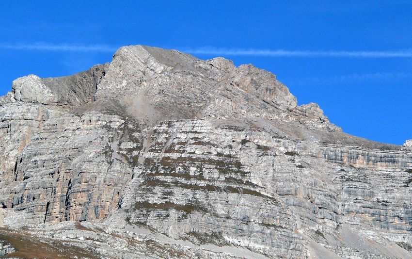
STOP 1.2: La Marogna landslide: a structurally controlled collapse (45.8953 °N, 11.3416 °E)
itinerary
The Stop is located in front of the landslide, on the left valley side and close to the bridge to reach the quarry
headquarters. In the middle part of the Astico Valley, where its orientation changes from W-E to N-S, a huge
(about 13 x 106 m3) rockslide deposit (La Marogna) was damming the valley (Figs. 16 and 17). The deposit is
mainly composed of dolostones and resulted from several rockfall events, the main of which can be possibly
referred to an important triggering seismic event (for a detailed discussion see STOP 1.7; cf. Fig. 45).
DOI: 10.3301/GFT.2018.01Past to present deformation of the central-eastern Southern Alps: from the foreland to the Giudicarie belt
A. Viganò - D. Zampieri - S. Rossato - S. Martin - L. Selli - G.Prosser - S. Ivy-Ochs - P. Campedel - F. Fedrizzi - M. Franceschi - M. Rigo
In recent years, the slide deposits
geological field trips and maps 2018 - 10(1.1)
were quarried on the left bank of
the Astico creek, while quarrying on
the right flank of the valley is still
ongoing. This activity has produced
a flat area on the valley bottom,
which is now suitable for human
development. The failure surface
corresponds to a fault plane dipping
35° towards the valley floor (Fig. 18);
this fault is clearly visible also along
the landslide crown (Figs. 19 and
20) (Zampieri and Adami, 2013).
The structural features observed at
the base of the main scarp (Figs. 19
and 20) would suggest that the La
24
Gioia slope represents a potential
Fig. 16 - Old photo towards the WNE showing the rockslide deposits damming
geologic hazard and that any
the Astico Valley. The slope failure occurred on the right slope of the valley (left
in photo), where the base of the main scarp lies 400 m above the valley floor. In development of the valley portion,
1278, the natural dam collapsed and the upstream lake vanished. formerly occupied by La Marogna
deposits, should be preceded by an
accurate risk assessment.
STOP 1.3: The Jurassic faults across the Vicentinean plateaux (45.9148 °N, 11.2712 °E)
itinerary
To reach the viewpoint, take the path behind the church (Località Togni) up to the forest edge. The outcrops
can be viewed on the opposite valley side.
The route along the Astico Valley goes through a sedimentary succession spanning from the Late Triassic to
the Cretaceous. The Dolomia Principale forms the lower portion of the Vicentinean plateaux and it is made of
dolostones organized in classical peritidal cycles deposited on a carbonate shelf. At the time of the Dolomia
DOI: 10.3301/GFT.2018.01Past to present deformation of the central-eastern Southern Alps: from the foreland to the Giudicarie belt
A. Viganò - D. Zampieri - S. Rossato - S. Martin - L. Selli - G.Prosser - S. Ivy-Ochs - P. Campedel - F. Fedrizzi - M. Franceschi - M. Rigo
geological field trips and maps 2018 - 10(1.1)
Fig. 17 - a) Location of the La
Marogna landslide (yellow line); the
red line is the contour of the rock
mass upstream of the crown (La
Gioia), potentially involved by a future
landslide. The white line is the designed
motorway trace (continuous: surficial;
dashed: underground) (Zampieri and
Adami, 2013). b) Oblique view of the
La Gioia upper slope and the upper
part of the La Marogna deposit. The
rockslide occurred on the northern limb
of an anticline (southern limb visible in
the background, in the upper right).
c) Viewing from north, the rockslide
main scarp is a 100 m-high face cliff.
25
Fig. 18 - a) Structural
sketch of the La Gioia
upper slope. b) Plots
(lower hemisphere) of the
main fracture/fault sets
recognized on the eastern
sector of the La Gioia upper
slope and of the slope face
with the failure plane. c)
itinerary
Natural cross section of
the La Marogna rockslide
showing the relationship
between bedding and
sliding surface (Zampieri
and Adami, 2013).
DOI: 10.3301/GFT.2018.01Past to present deformation of the central-eastern Southern Alps: from the foreland to the Giudicarie belt
A. Viganò - D. Zampieri - S. Rossato - S. Martin - L. Selli - G.Prosser - S. Ivy-Ochs - P. Campedel - F. Fedrizzi - M. Franceschi - M. Rigo
geological field trips and maps 2018 - 10(1.1)
Fig. 19 - a) Base of the La Marogna rockslide Fig. 20 - The fault rock is a non-cohesive several dm-thick gouge.
main scarp. b) Detail of the fault plane continuing 26
beneath the main scarp wall face.
Principale deposition, the Southern Alps were occupied by a wide carbonate platform. This flat paleogeography
was progressively fragmented by extensional tectonics connected to the rifting that ultimately led to the
break-up of Pangea (Winterer and Bosellini, 1981). Subsidence along extensional faults caused the formation
of a series of horsts, where shallow water carbonate platforms persisted, and basins, where deep-water
sedimentation occurred. The Trento Platform high was bounded to the E by the Belluno Basin and to the W
itinerary
by the Lombardian Basin, and hosted shallow water carbonate sedimentation (Calcari Grigi Group) until the
Toarcian (Masetti et al., 2012 and references therein). The Trento Platform witnessed a complex history as
testified by important changes in facies architecture of the units of the Calcari Grigi Group. Major facies changes
occur in coincidence with global perturbation of the carbon cycle (Sinemurian-Pliensbachian boundary Event,
Franceschi et al., 2014b). Pulses of extensional tectonics since the Sinemurian are testified by syn-sedimentary
faulting that induced differential subsidence and caused relevant thickness variations particularly evident in
DOI: 10.3301/GFT.2018.01Past to present deformation of the central-eastern Southern Alps: from the foreland to the Giudicarie belt
A. Viganò - D. Zampieri - S. Rossato - S. Martin - L. Selli - G.Prosser - S. Ivy-Ochs - P. Campedel - F. Fedrizzi - M. Franceschi - M. Rigo
the Rotzo fm. (Franceschi et al., 2014a). The onset of
geological field trips and maps 2018 - 10(1.1)
deep-water conditions in the Southern Alps and also
in the area occupied by the Trento Platform is marked
by a generalized marine transgression (San Vigilio
Oolitic Limestone) and by the following deposition
of the Rosso Ammonitico Veronese and the cherty
limestones of Maiolica.
Along the upper Astico Valley section, the Lavarone
plateau (Fig. 21) shows a prominent high-angle
W-dipping normal fault (Carotte fault, Fig. 26),
which was active during the Pliensbachian (Fig. 22).
The syn-sedimentary activity is demonstrated by a
hanging-wall rollover anticline, with thickening of
the Rotzo fm. towards the fault (Fig. 22).
STOP 1.4: The Cornetto-Becco di Filadonna pop-up
(45.9412 °N, 11.2324 °E) 27
From Carbonare (1076 m; Stop located in a service area
along the SS349 road from Carbonare to Lavarone),
located on the saddle between the Astico and Centa
valleys, the uplift structure of the Cornetto-Becco di
Filadonna is prominent (Figs. 23-25). The southern
slope of the Cornetto di Folgaria corresponds to the
forelimb of the anticline developed in the hanging-wall
itinerary
Fig. 21 - LiDAR image (a) and geological map (b) of the
southern Lavarone plateau and upper Astico Valley. DPR
Dolomia Principale, FMZ Monte Zugna fm., LOP Loppio Oolitic
Limestone, RTZ Rotzo fm., OSV San Vigilio Oolitic Limestone,
ARV Rosso Ammonitico Veronese, MAI Maiolica.
DOI: 10.3301/GFT.2018.01Past to present deformation of the central-eastern Southern Alps: from the foreland to the Giudicarie belt
A. Viganò - D. Zampieri - S. Rossato - S. Martin - L. Selli - G.Prosser - S. Ivy-Ochs - P. Campedel - F. Fedrizzi - M. Franceschi - M. Rigo
geological field trips and maps 2018 - 10(1.1)
Fig. 22 - a) Left side of the upper Astico Valley with the
Jurassic Carotte fault. b) Minor normal faults antithetic
to the Carotte fault. c) Graben on the hanging-wall
(HW) of the Carotte fault. d) Numerical model of a listric
normal fault with rigid footwall block (FW). The Maximum
Coulomb Shear Stress (MCSS) results in the hinge of the
hanging-wall rollover anticline (Maerten and Maerten,
2006). e) Analogue model of a listric normal fault with
rigid footwall block. An active deformation area of the
hanging-wall is located in the hinge zone of the rollover
anticline (Maerten and Maerten, 2006; cf. McClay,
1990). f) Cross section of the Carotte fault showing the
thickening of the Rotzo fm. (RTZ) towards the fault. This
permits to infer that the fault activity started during the
Pliensbachian, but a syn- or post-Maiolica extensional
activity is also present (legend as in Fig. 21b).
of the NW dipping Centa fault, probably a Jurassic
fault reactivated as a sinistral transpressional fault
28
(Zampieri et al., 2003).
At the head of the Centa Valley, below Terza Cima,
erosion is active on the highly fractured fault rocks
produced by the Terza Cima-Spizom reverse fault, a
steep backthrust of the Centa fault (Figs. 23 and 24).
This prominent structure seems to be active, as
suggested by seismicity occurred on October 1994 (Tab. 1) (Viganò et al., 2008; 2015). In particular, the
Monte Cornetto area shows dominantly compressive focal mechanisms of relatively shallow earthquakes, while
itinerary
the bordering faults (Schio-Vicenza to the west and Gamonda-Tormeno-Melegnon-Carotte system to the east)
show focal mechanisms with dominant strike-slip components (Fig. 26 and Tab. 1). At least in this internal
Southern Alps sector, at present the Schio-Vicenza fault shows dextral strike-slip kinematics (Fig. 26) (Viganò
et al., 2015). It should be considered that the epicentral position of the 1989 seismic event (pre-1994 seismic
network) is surely affected by higher uncertainties than other solutions.
DOI: 10.3301/GFT.2018.01Past to present deformation of the central-eastern Southern Alps: from the foreland to the Giudicarie belt
A. Viganò - D. Zampieri - S. Rossato - S. Martin - L. Selli - G.Prosser - S. Ivy-Ochs - P. Campedel - F. Fedrizzi - M. Franceschi - M. Rigo
The Monte Cornetto di Folgaria is a topographic and structural high bounded by two conjugate reverse faults:
geological field trips and maps 2018 - 10(1.1)
the Trento-Roncogno fault to the north, and the Centa fault to the south. This uplift has been interpreted
as a pop-up localized at the restraining stepover between the presently sinistral Calisio and Schio-Vicenza
strike-slip faults, which trend at high angle to the thrust belt (Zampieri et al., 2003). However, the seismicity
of the Schio-Vicenza fault in the Pasubio area, i.e. north of Posina, suggests a dextral strike-slip activity, a
kinematics confirmed also by the field analysis (Fondriest et al., 2012). The apparent contradictory kinematics
of the Schio-Vicenza fault in its different segments could be explained by the pop-up structure development,
which requires a dextral activity along its western margin, while the segment south of Posina producing the
contractional stepover requires a sinistral activity. This structure could fall within the “sinistral opening zipper”
model of Passchier and Platt (2017), where intersecting pairs of simultaneously active faults with different
sense of shear merge into a single fault, via a zippered section (extraction fault) eventually experiencing no
displacement.
29
itinerary
Fig. 23 - Panoramic view of the Cornetto di Folgaria (from Carbonare, towards NW).
DOI: 10.3301/GFT.2018.01You can also read