MAGPIE CREEK Geological trail STURT GORGE RECREATION PARK - A walk through time into the ancient glacial rocks of South Australia's Sturt Gorge
←
→
Page content transcription
If your browser does not render page correctly, please read the page content below
MAGPIE CREEK
       Geological trail
       STURT GORGE RECREATION PARK

A walk through time into the ancient glacial rocks of South Australia’s Sturt Gorge

                              South Australian Division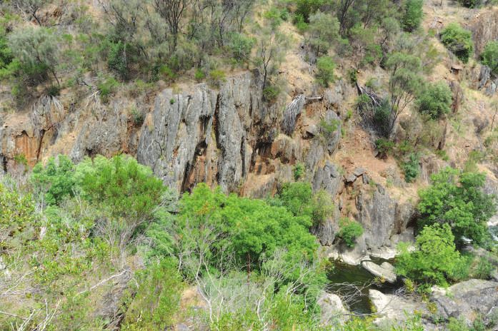
South Australian Division
                                                www.sa.gsa.org.au

                        Compiled by Colin Conor (STEM, University of South Australia) and
                              Cynthia Pyle (Field Geology Club of South Australia)
                                 for the Geological Field Guide Subcommittee.

                                                       April 2021

The walk is within the Sturt Gorge Geological Heritage Site M4.
Cover photo: Westerly view from the head of the Sturt Gorge, along the base of the siltstone marker bed, at
the top of the lower part of the Sturt Tillite. In the foreground, a pothole ground into solidified ancient glacial
debris, i.e. tillite.
28/04/2021-205479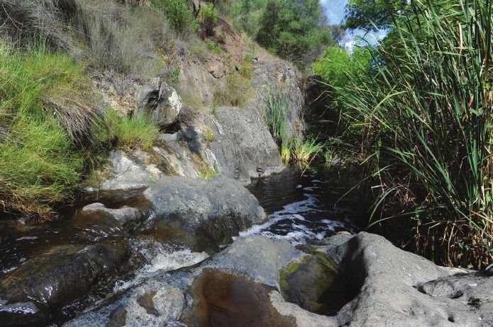
Contents
Introduction...............................................................................................................................4
Geological history....................................................................................................................6
Towards the formation of today’s scenery: 45 Ma to the present..........................7
South Australia’s great glacial controversy.....................................................................8
The walk.......................................................................................................................................9
Acknowledgements............................................................................................................. 25
References................................................................................................................................ 25

                                                                                                                                                   3
Introduction                                                        Exposed rocks of the                              QLD
If you want to learn about previous                                 Adelaide Geosyncline
                                                                    including Sturt Tillite
glaciations on Earth, you’ve come to the
right place – South Australia’s Sturt Gorge
Recreation Park (Fig 1). Sturt Gorge’s name
has been introduced to the world as the
‘Sturtian Glaciation’, perhaps the greatest
of several ancient glacial events.             Concealed rocks of the

                                                                                              ES
                                               Adelaide Geosyncline                                                   NSW

                                                                                           ANG
Adelaide is fortunate in having

                                                                           F L I N D E RS R
spectacular gorges that dissect the steep
scarp-face of the Mount Lofty Ranges.
The Sturt River not only displays a
fascinating landscape, but also erosion
has created a window that allows an

                                                                                             Y RANGES
excursion into the depth of time. The
gorge cuts deeply through the Mount

                                                                                           T
Lofty Ranges, separating the suburbs of

                                                                                        LOF
                                                                   ADELAIDE                             Sturt Gorge
Bellevue Heights and Flagstaff Hill (Fig 2).

                                                                                   MT
                                                                                                        Recreation Park
                                                       KANGAROO
The 244-hectare Sturt Gorge Recreation                 ISLAND

Park protects the heritage-listed Sturt                                                                               VIC

Gorge Glaciation Geological Site.              205479-001
The site is one of the first places in the
world where rocks were found to show
evidence of glaciation
occurring about 665                                                Brighton
million years ago            (a)
(c. 665 Ma), prior
to the existence of
animal life.
                                                                         Flinders
                                                                        University
Figure 1 Location of the
Sturt Gorge Recreation Park
and extent of the Adelaide
Geosyncline sedimentary
basin, which includes the                                      Sturt River
Mount Lofty and Flinders
                                                                                                         Belleview
ranges.                       Flagstaff Hill                                                              Heights

Figure 2 Views of Sturt
                                                                  Magpie
River. (a) Oblique aerial                                         Creek
view (Google Earth)                                                loop
looking west along the                                                                                    Gorge R
                                                                                                                    oad
Sturt River and showing       Dam
the location of the Magpie                          Craigburn Farm
Creek geological trail..

4
(b)                                                        (c)

                        Magpie Creek

(b) Northeasterly view of the eastern end of Sturt Gorge   (c) Southwesterly view from Bellevue Heights of the
in the region of Magpie Creek                              flood mitigation dam in the Sturt River.

This guide explains why the landform exists
and what the rocks tell us about the history
of the Earth, including ancient changes in
climate. Clues are given in the rocks that
crop out along the steep banks of the Sturt
River and its tributary, Magpie Creek. What
we see now is a snapshot of the immensity
of geological time represented by scraps
of geological history written in those rocks.
The rocks contain evidence for a lengthy
period when the Earth was prone to cyclical
freezing. At times glaciation was so extreme
that the whole world is thought to have
been enveloped extensively or entirely
by ice (Fig 3). This period is known as the
‘Cryogenian’ [from cryogene: Greek kryos
– cold; genes – born], popularly referred                  Figure 3 An artistic impression of Earth from
to as ‘Snowball Earth’. Two components of                  space during one of the more extreme cycles of the
the Cryogenian are represented in South                    Cryogenian period. In this interpretation everywhere
Australia – the Sturtian (described herein)                from the equator to the poles is covered with ice. At
and Elatina (or Marinoan) glaciations.                     other times there was sufficient movement for the flow
                                                           of glaciers to erode, transport and deposit rock debris.
The rocks exposed along Sturt River also                   (Courtesy of NASA)
provide glimpses into the tectonic setting
– i.e. the process that controls the structure
and properties of the Earth’s crust and its
evolution through time (source: Wikipedia).

                                                                                                                  5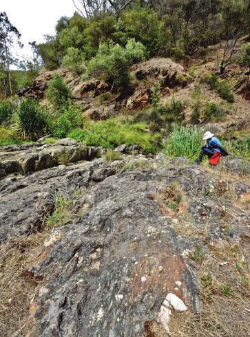
Geological history
The Earth’s crust is never motionless and the Australian continent is currently moving
northward at about 6 to 7 cm each year. Australia was once part of 3 supercontinents –
Gondwana, Pangea and the much older Rodinia (Fig 4a). Our story starts at c. 830 Ma when
the continental crust of Rodinia first began to fracture – basalt erupted along faults and
extruded into incipient rift valleys (Fig 4b). However, the glacial sedimentary rocks seen
along the Sturt River were not laid down until about 170 million years later, a time interval
during which a thickness of several kilometres of sediment had already accumulated in a
sedimentary basin traditionally known as the Adelaide Geosyncline. Rodinia finally fully broke
apart after the Sturtian Glaciation. The Adelaide Geosyncline is now represented by the rocks
of the Mount Lofty and Flinders Ranges (Fig 4c).

(a)                                                                                        Evolution of the Adelaide
                               RODINIA c. 950 Ma
                                                                                           Geosyncline lasted for 315 million
                                      AUSTRALIA                                            years between 830 and 510 Ma,
                                                                                           and includes the Cryogenian period
                                                                                           which lasted roughly 85 million years
                                                                                           from 720 to 635 Ma (Fig 5).
                                                                                           The glacial deposits in the Sturt
                                                                                           Gorge are estimated to be c. 665 Ma.

                                                                                           Figure 4 Formation of the Adelaide
                                                                                           Geosyncline. (a) One interpretation
                                                                                           of how the continental masses were
                                                                                           clumped together as the supercontinent
    Abbreviations: A-A, Afif-Abas Terrane; Am, Amazonia; Az, Azania; Ba, Baltica; Bo,      of Rodinia c. 950 Ma. At the top right
(b)
    Borborema; By, Bayuda; Ca, Cathaysia (South China); C, Congo; Ch, Chortis; G,          proto-Australia is depicted as two parts
 Greenland; H, Hoggar; I, India; K, Kalahari; L, Laurentia; Ma, Mawson; NAC, North         (NAC and SAC) alongside Antarctica
    Australian Craton; N-B, Nigeria-Benin; NC, North China; Pp, Paranapanema; Ra,
    Rayner (Antarctica); RDLP, Rio de laSea
                                         Plata; SAC, South Australian Craton; SF, São      (Ma). (Reprinted from Merdith et al.
    Francisco; Si, Siberia; SM, Sahara Metacraton; WAC,West African Craton. Shaded         2017, fig 6a, with permission from
    grey area is inferred extent of Rodinia and is meant as a guide only. The              Elsevier). (b) A diagrammatic cross-
     Rift valley
    longitude  is arbitrary and unconstrained, and used here  Sediment        fill
                                                                as a relative reference.
    Cratonic crust is coloured by present day geography: North America, red; South         section of a foundered and sea-flooded
    America, dark blue; Baltica, green; Siberia, grey; India and the Middle East, light    rift valley – basalt erupts along faults,
    blue; China, yellow; Africa, orange; Australia, crimson; Antarctica, purple.           and sediments are derived from the
                                                                                           weathering and erosion of the high
                                                                                           ground of the rift flanks.

                                                                   Figure 5 The last 1,000 million years of Earth’s history
                                                                   highlighting geological history recorded in in South Australia:
                                                                   1 Cryogenian, c. 720–635 Ma, e.g. Sturt River. 2 Permian,
                                                                   c. 320–300 Ma, e.g. Hallett Cove, Adelaide. 3 Cretaceous,
                                                                   c. 125 Ma, e.g. Mount Painter, northern Flinders Ranges.
                                                                   4 Pleistocene, c. 2.5–0.012 Ma, e.g. interglacial glacial deposits
                                                                   such as the Woakwine Range in the South East. [The age of
                                                                   dinosaurs (non-bird versions) is represented very approximately
                                                                   by the gap between 2 and 3, while that of humans is
                                                                   approximately from 4 to the present.]

6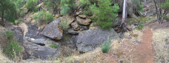
Towards the formation of today’s scenery: 45 Ma to the present
Following the breakup of Rodinia, Australia and Antarctica continued to move as part of
Gondwana which amalgamated with other elements to form the supercontinent of Pangea at
c. 335 Ma. Tectonic forces within the Earth started to disrupt Pangea from c. 180 Ma and the
smaller continental masses separated, dispersing at a rate of many centimetres per year.
Just like an eggshell the continental crust is rigid but also brittle, which means that it can
crack. Cracks in the continental crust, across which there has been displacement, are called
faults, and over the immensity of geological time many generations of faults form, intersect
and reactivate.
The northwards drift of Australia                                   (b)
from Antarctica accelerated
at c. 45 Ma (Fig 6). Australia
                                        (a)
was undergoing west–east
compression, which caused
uplift and, moreover, the stresses
activated new and ancient faults
which promoted the formation
of restricted marine basins
and ranges of hills. In South
Australia a series of step-like
blocks evolved to form today’s
Mount Lofty Ranges, which are
still on the rise due to episodic
activity along the faults (Preiss
2019). The Sturt River owes its
existence to the combination of
tectonism and climate, that is the     Figure 6 The relationship of Australia and Antarctica.
past and continuing uplift of the      (a) Following the breakup of Pangea, c. 45 Ma. (b) Separation at
                                       present. (Adapted from Müller et al. 2000)
ranges together with ongoing
weathering and erosion of the
exposed rocks.
Climate and tectonics are crucial geological forces, but no one place contains all of the
evidence explaining the geological evolution of the Earth – everywhere the evidence is
fragmentary, with most of geological time represented by great gaps in the record (Fig 5).
While this is true for the Sturt River, there are 4 events that are preserved in rocks to show
what has happened:
•   Formation of the Adelaide Geosyncline rift basin, initiated c. 830 Ma. Evidence: the
    rocks of the Flinders and Mount Lofty ranges are the sediment fill of the basin and include
    early basalts and evaporite deposits (e.g. salt, gypsum), which are evidence for rifting.
•   Great freeze of the Sturtian Glaciation, c. 665 Ma. Evidence: glacial sediments called
    tillite (described at site G2).
•   Formation of an extensive mountain chain, c. 515–490 Ma – the Delamerian Orogeny
    and the uplifted and exhumed sedimentary fill of the Adelaide Geosyncline basin.
    Evidence: the Flinders and Mount Lofty ranges, deformation of the rocks including folds
    and faults, and metamorphic minerals and textures (also described at site G2).

                                                                                                          7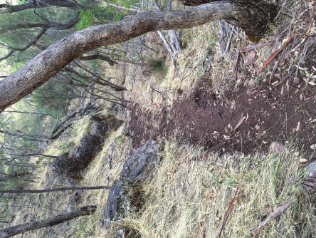
•         Formation of current landscape, c. 45 Ma to present day – renewed uplift along
          reactivated Delamerian faults continuing episodically to the present day. Evidence: the
          steep slopes of the Sturt River, including the Sturt Gorge and Magpie Creek, rock debris
          gravitating slowly down the valley sides, and boulders driven more rapidly down the river
          by floodwaters.

South Australia’s great glacial controversy
From a world perspective Sturt Gorge first came to prominence in 1900 when the Reverend
Walter Howchin, one of South Australia’s early geologists, demonstrated that glaciation
must have deposited the rocks that he and others, including the Government Geologist, HYL
Brown, had studied along the Sturt River (Fig 7). In 1901 he gave the rocks the stratigraphic
name Sturtian Tillite. However, not everyone agreed with Howchin’s glacial interpretation
and from 1905 to 1912 there was fierce debate amongst Adelaide geologists that gained
substantial press coverage as the ‘Great Glacial Controversy’. In 1906 the subject was
highlighted at the International Geological Congress in Mexico and in 1907 the Australasian
Association for the Advancement of Science conference held in Adelaide provided an
opportunity for the nation’s geologists to discuss the issue and visit Sturt Gorge. In 1914
Walter Howchin led a delegation from the British Association for the Advancement of Science
to Sturt Gorge.
In 1950 the name Sturtian Tillite was modified to Sturt Tillite, the word Sturtian being
reserved for the time period called the Sturtian Epoch (and the Sturtian Glaciation). Evidence
for Sturtian Glaciation is now known from every continent except ice-blanketed Antarctica.

    (a)                                                      (b)

Figure 7 Two of the several luminaries interested in the rocks of the Sturt Gorge – both supported the glacial
hypothesis against considerable opposition. (a) Professor Walter Howchin, University of Adelaide, 1845–1937.
(b) HYL Brown, Government Geologist, 1843–1928.

8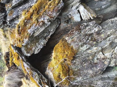
The walk
Getting there
The Magpie Creek geological trail
is in the Sturt Gorge Recreation
Park and is accessed from the
north via Shepherds Hill Road
where it passes through Bellevue
Heights (Fig 8). A choice of 3 side
roads – Sargent Parade, Eden
Avenue or Adam Avenue – lead
southward to Eve Road. The walk
starts at the southern end of the
Gorge Road loop, a no-through
road, which is accessed from
Eve Road.
Access is available by public
transport – currently bus routes
600, 601 and G30F which service
Shepherds Hill Road between
Blackwood Interchange and
Marion Centre. Bus Stops 28, 28A
and 29 are suitable. The walking
distance from Shepherds Hill Road
to the start of the geological trail
off Gorge Road approximates
1.25 km. Please check Adelaide
Metro route information as the
services are irregular.
Many of the tracks are steep and
rough underfoot, and require
caution, a reasonable amount of
fitness and appropriate footwear. Figure 8 Location map showing the start of the Magpie Creek
geological trail from Gorge Road, Bellevue Heights.
Beware of snakes in spring and
summer.
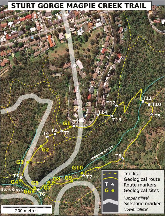
The trail commences at the southern end of the Gorge Road loop (Fig. 9). Trail markers (T1, T2
etc.) indicate reference points such as other intersecting tracks. The steepest parts of the walk
are those dropping down to the Sturt River (T1–T5), ascending from the waterfall site (i.e.
after G7), and finally climbing back up from Magpie Creek to Gorge Road (T10–T12). Ten sites
of geological interest have been selected along the trail (G1–G10). The GPS locations (UTM
WGS84 Zone 54) of trail markers and geological features are provided for each site. Directions
are shown in italics.
9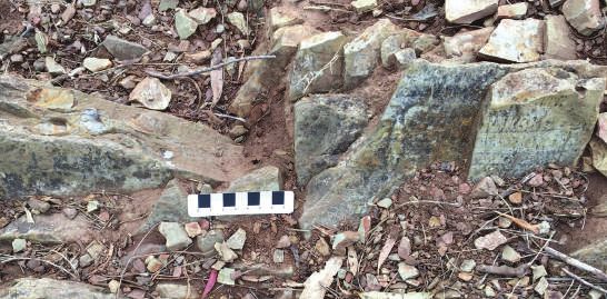
N

Figure 9 Map of a portion of Sturt Gorge Recreation Park showing the Magpie Creek geological trail and the
approximate position of a geological rock unit labelled the ‘siltstone marker’. The siltstone marker separates the older
‘lower tillite’ in the east from the younger ‘upper tillite’ to the west. Points labelled in white as T1, T2 etc. on the map
refer to trail makers, or route locations along the track with guide instructions in the text shown in italics. Points
labelled in yellow i.e. G1, G2 etc. refer to the locations of geological interest that are described in this guidebook. Each
G point has a brief description of the geology at that site. The start of the walk from Gorge Road is shown as route
marker T1.
10
T1, G1: Southern end of
Gorge Road, Bellevue Heights
279960 mE, 6120320 mN
The recommended start of the
walk is at the south end of the
Gorge Road loop (Fig 9). There is a
flat area off the south side of Gorge
Road which is a SA Water pumping
station beside a power (Stobie)
pole (Fig 10). If you have arrived by
car, parking nearby is convenient
for access to the start of the trail.   Figure 10 View looking southwest to the start of the walk (near
                                        the car). This is the southern end of the Gorge Road loop showing
The walk commences 20 m further
                                        the power pole and the pavement of the SA Water pumping
west of the pumping station where       station. Location T1 is near the car.
there is an unsigned track heading
downhill. Walk down the track for
about 25 m until you come to the
scene shown in Figure 11.
As you follow the track down off
Gorge Road, you are at the top
of Sturt Gorge ravine with the
well-treed area falling away steeply
to the south (Fig 11). It is steep
because the Sturt River is actively
eroding downwards as nature
attempts to reduce the topography
to sea level. Looking back in time,
the present spectacular scenery
of the Sturt Gorge originated c.
45 Ma following the breakup of
the supercontinents Gondwana
and Pangea and after Australia
separated from Antarctica.
Continue the walk to site G2.
Walk downhill for 25 m, cross over
the marked Tapa Turrungha Trail
(T2). A further 25 m takes you to
another crossing track, cross over
this and continue downhill past
a post with a blue survey marker
(T3).                                   Figure 11 The start of the walk a few metres from Gorge Road,
                                        looking downhill past the intersection of the Tapa Turrungha Trail
                                        to the blue survey post in the middle distance. A hint of what is to
                                        come – the track disappears from view, being replaced in the far
                                        distance by the steep southern flank of the Sturt River topped by
                                        the suburb of Flagstaff Hill.

                                                                                                         11
T3 (a)
279893 mE, 6120338 mN
Blue survey marker, continue downhill,
leaving the survey maker on your right.
Old
disused
T4 path
279890 mE, 6120280 mN
The track bends around to the left turning New
away from an older track (Fig 12a). Continue path
walking for about 50 m to the left and
downhill to G2, a bold outcrop of rock that
juts across the track at a bend in the track
(Fig 12b). (b)
G2: Sturt Tillite
279850 mE, 6120261 mN
This site showcases tillite, a rock formed
by the action of ice during glaciations. The Geological
name comes from the word ‘till’ as it was site G2
used in old Scotland meaning ‘obstinate
land’, the English name being ‘boulder clay’.
As the latter name implies, till, or more
correctly ‘glacial till’, is a mixture of various
rocks of different types and sizes set in a
similarly mixed-up gritty clayey matrix.
Tillite is glacial till that has become solidified
through time, generally because it has been
turned into rock by burial pressures due to
the loading during ongoing sedimentation
within the sedimentary basin.
Tillite is the dominant type of rock present
below the vegetation and soil along the
Sturt River. Where freshly exposed it is a
dark-grey rock made distinctive by obvious Figure 12 (a) The former T4 track has been rerouted
directly to the rock outcrop of G2. (b) Geological site G2.
rock fragments – some rounded, some
angular – set in a gritty matrix of finer
grained clay, mica, feldspar and quartz,
which are common minerals that together
form much of the Earth’s crust.
12(a) Look at the outcrop of tillite carefully
(Fig 13). It contains fragments (called clasts)
of many different rock types embedded in
the fine-grained material that is the matrix.
Some of the clasts are angular, while many
others are rounded. Also, there is a wide
range of clast sizes – geologists describe the
rock as poorly sorted.
(c)
(b)
Split cast
Figure 13 Original form of till after it was deposited from a glacier at c. 665 Ma. (a) Note details of the outcrop face,
especially the embedded rock fragments (clasts) in the tillite. The light brown to rusty red colouring is due to present-
day weathering. (b) Clasts shown in detail. (c) The left-hand side of the outcrop, illustrating what happened to the
tillite later when it was buried deep within the roots of a mountain chain (c. 510 Ma). A large rock fragment (clast) is
wrapped by a streaky texture called ‘cleavage’, in this case ‘slaty cleavage’. [Slaty cleavage is an approximately planar
structure developed in a rock due to the preferred parallel orientation of platy minerals, such as fine grain-sized mica.
It causes the development of a fabric or weakness throughout the rock along which the rock can be readily split or
cleaved.]
13The clasts range in size from granules to boulders. They vary greatly in composition due to being plucked and transported by ice from distant and different source areas, and the different parent rocks in those areas – e.g. Eyre Peninsula and Antarctica (co-components of the supercontinent of Rodinia). This mixture of clast sizes and variation of clast rounding reflects their origin from different glacial environments before they were incorporated in a mass flow slurry of mixed materials. The angular clasts would have settled into the till quickly after leaving the thawing ice, but the rounded clasts, which are more common along the Sturt River, were tumbled in meltwater streams before they were deposited in the glacial till. Tillite outcrops like those at G2 demonstrate that moving glacial ice has torn rock fragments from the distant lands over which it travelled. The ice carried these fragments along to form moraines (angular clasts) and outwash debris from glacial rivers (rounded clasts). The advance and retreat of glaciers to and from the ocean, which covered G2, resulted in immense quantities of unsorted rock fragments of all sizes – from fine clay sized particles up to large boulders – being released from floating ice to fall to the ocean floor to form glacial till, now visible as tillite at G2 (Fig 14). Figure 14 Diagrammatic geological cross-section showing the environment of formation of the Sturt Tillite. Rock fragments and rock flour were carried into the sea by glaciers and floating ice to be deposited as the ice melted (after Rawolle 2011). (A craton [from Greek kratos – strength] is an old and stable part of a continent – in this case Eyre Peninsula). 14
Thickness of the Sturt Tillite is hard to estimate as it is massive broadly homogeneous rock
that has been complexly deformed by later tectonic forces. Fortunately, restricted lenticular
(lens-like) sandstone beds and a siltstone marker bed, interleaved with the tillite, help with
the structural puzzle (Fig 9; sites G3–G8).
There is more to this outcrop!

Building of an ancient mountain chain
The matrix of the tillite that surrounds the clasts possesses a streaky texture known as
cleavage (Fig 13c). This texture was formed c. 500 Ma by extreme pressure during the
Delamerian Orogeny mountain-building event. The tectonic pressure caused flakey minerals
such as mica to grow in the matrix perpendicular to the pressure direction (Fig 15).

   (a)                                                  (b)
         Original horizontal bedding                                                                       Shear
                                                      Folded bedding

                                                           West                                                 East

                                                                                                 C
                                                                                                  le
                                                                                                    av
                                                                                                      ag
                                                                                                        e

                                                              Quartz fibres

           Original reference square                                               Sheared reference ‘square’
           containing clay minerals                                             containing stretched and split clast
                and round clast                                                  and clay metamorphosed to mica

Figure 15 Diagram showing what happened to the tillite during the Delamerian mountain-building orogeny.
(a) Till, sandstone lenses and the siltstone were deposited to form horizontal beds in which there were clasts (brown
circle) enclosed in a matrix containing much clay. (b) The rocks were buried to great depths and compressed to
become tillite. Then tectonic pressures from the east caused them to be deformed by folding and faulting. Also, the
original clay minerals were transformed (metamorphosed) into mica, so that the flakes, aligned at right angles
to the direction of pressure, form the cleavage. Generally, the cleavage is distorted by wrapping around the large
rigid clasts (displayed at site G2, and spectacularly so at G7). The clasts too have reacted in different ways, the most
striking being that in stretching some quartzite clasts have split.

Continue downhill to site G3 noting scattered rocks on the way – flattish pieces of tillite that have
been displaced along weaknesses caused by the cleavage. Site G3 is marked by a subsidiary track
joining from the left.

                                                                                                                       15
G3: Siltstone marker bed
279804 mE, 6120195 mN
The rubbly exposure of rock on the track is rather unimpressive and consists of grey-green to
brown weathered siltstone, which is a fine-grained, thinly layered or laminated rock (Fig 16a).
It is formed from fine silt sized quartz, and possibly feldspar particles, and a minor amount of
clay that settled out of relatively calm water, but unlike the tillite it is generally well sorted.
These layers mark the bedding planes that were formed by changes in the nature of the
material that was being deposited at that time (Fig 16b). The presence of the siltstone bed, in
contrast to tillite, indicates that environmental conditions briefly changed during the glacial
period.
(a) Figure 16 Site G3, the siltstone marker
bed. (a) The rock outcropping as rubble on
the track is siltstone, which means that is
made up of fine-grained particles, mainly
of quartz. (b) Detail of a piece of siltstone
on the right showing thin parallel bands –
these are layers, which are called beds. The
beds were formed by the settling of silt from
Site G3 relatively still water, such as a lake or below
floating ice that was free of rock debris.
Unlike the rock at locality G2, there are only
infrequent clasts. A few are shown to the left
of the scale bar, and are embedded in the
siltstone having been dropped from floating
ice, which on this occasion did contain
glacial debris.
(b)
Siltstone with
Siltstone with clasts bedding layers
Significantly, the rock unit is a geological marker bed – a marker bed being a layer of a
distinctive rock that can be traced for long distances (Fig 9). Here at site G3 this fine-grained,
thinly layered siltstone marker bed lies within the tillite mass dividing the tillite into two – a
lower older tillite and upper younger tillite. In Figure 16a the upper tillite is to the left of
the track and the lower one is to the right. The significance of the siltstone marker bed is
discussed further at the next site.
16Continue downhill following scrappy exposures of the marker bed in the track. At the top of the
Sturt Gorge the track intersects with the River Trail (T5). When you arrive at site T5, G4 you will
be standing on a tillite unit which is below the siltstone marker bed and from now on you will be
walking in the older tillite unit.
T5, G4: View of the main Sturt Gorge
279779 mE, 6120131 mN
The track joins the River Trail, which follows Sturt Creek.
From this location, at the junction with River Trail, you can look down into the head of
the Sturt Gorge which follows the westerly course of the Sturt River, i.e. to the right. The
geological reason for the existence of the steep-sided gorge is that the Sturt River is cutting
downwards in reaction to the past and continuing episodic uplift of the Mount Lofty Ranges
(you will see spectacular evidence for this at site G10).
Looking across the gorge, the rocks of the lower tillite have a vertical pillar-like form due to
the metamorphic cleavage which is more steeply inclined at this locality than it is elsewhere
(Fig 17). The top of the ‘pillars’ marks the base of the siltstone marker bed.
r
e marke
base o f siltston
Possible
Cleavage
Figure 17 The view from site G4 is of the rocky start of the main part of the Sturt Gorge. The rocks forming the
small cliffs on the other southern side of the gorge are made of the lower tillite. The sloping but relatively planar top
to the tillite suggests that it is the contact of the base of the siltstone marker bed that we saw at site G3, and will see
in sites G5 to G8. The column-like nature of the outcrop is due to the tillite being preferentially weathered and eroded
along planes of weakness parallel to the near vertical cleavage.
17The cleavage in the tillite at site G4 indicates that the rocks along the Sturt River have been deformed and folded. Mapping of the siltstone marker bed (Fig 9) has shown that the rocks along the Sturt River (and the Mount Lofty Ranges in general) have been deformed into folded shapes, which in cross-section look like knees or elbows (Figs 15, 18). Both the folding and the formation of cleavage are due to pressure exerted from the east during the ancient Delamerian Orogeny. Figure 18 shows the geology of the Sturt Tillite as an east–west cross- section viewed looking south across the Sturt River. Figure 18 Simplified schematic east–west cross-section showing how the marker bed defines the folded shape of the Sturt Tillite as it is between Eden Hills in the east and Flinders University in the west. View looking south. From site G5 to G8 the orientation of the siltstone changes from near horizontal to near vertical. This style of knee-shaped fold is typical for this part of the Mount Lofty Ranges. The white upper part of the diagram represents rock that has been lost to erosion, a process that continues today. The lowest part of the diagram shows the underlying pre-glacial sediments that are called the Burra Group. Before you leave this location look upstream towards the left to view the dam which has been built across the Sturt River to protect the downstream suburbs from flooding (Fig 2c). Turn left and follow the River Trail for about 50 m to G5. 18
G5: Bedding and cleavage in the siltstone marker bed
279827 mE, 6120083 mN
You are now standing on the top of the lower tillite (Fig 19a). The rock outcrop on the left-
hand side of the trail is the siltstone marker bed continued from site G3.
The surface facing you is a near-vertical joint surface (a natural planar crack in the rock;
Fig 19b). By examining the joint surface closely you will see 2 different sets of parallel lines.
The horizontal set is the bedding and the set inclined to the right is the cleavage (Figs 19b, c).
 (a)                                                (d)

                                                                                Clast

                                                              Cleava
                                                                     ge

                                                   Bedding
                                                   Like the rock at site G3 here the bedding
                                                   suggests deposition of sandy sediment in fairly
                                                   quiet water, although ripple-like structures (c)
 (b)                                               do suggest some current activity. Originally
              Ripple marks
                                                   this rock was not purely composed of silt-sized
                            Small clast            particles because it contains larger scattered
                                                   quartz granules and occasional pebbles (d).
                                                   These coarser fragments were likely to have
                                                   been deposited from floating glacial ice. The
Bedding
                                                   sediments were deposited at about 665 million
            Cle

                                                   years ago, during the Sturtian Glaciation.
               ava

                                                   Cleavage
                  ge

                                                   The set of lines that are inclined to the right
 (c)                                               (i.e. east) represent the intersection of irregular
                                                   cleavage planes with the joint face, and are
                                                   equivalent to the cleavage viewed in the tillite
                                                   at site G2. The cleavage is the evidence at this
                                                   site for the Delamerian Orogeny, the major
                       Detail of ripple mark       mountain building event that was imposed
                                                   about 150 million years after the Sturtian ice
                                                   age. Also visible in this outcrop are irregular
                                                   cracks in the rock that are partly filled with
                                                   quartz, these represent later faulting.
                                                   Follow the River Trail a few metres and turn right
                                                   to a rock platform beside the Sturt River.

                                                                                                19
G6: Tillite platform displaying a
variety of clasts River is the siltstone marker bed; it displays
72980 mE, 6120098 mN details that significantly show changes in the
glacial setting (see the explanation of Fig 20
Here the lower tillite contains many
for more detail).
fragments of different rock types that vary
from rounded to angular in shape (Fig 20) Crossing the river is not recommended as the
like the upper tillite seen at site G2. rocks are slippery, additionally the long grass
Also repeated to the south across the Sturt on the far side provides an ideal snake habitat.
(b)
(a) Upper tillite
one
iltst
of s
Top
it
itio nal un
Marker bed Trans r
arke
sto ne m
o f silt
Base
Lower tillite
(c)
e
Lower
g
Cleava
tillite
Figure 20 (a) View looking south across the Sturt River to
the siltstone marker bed forming the far bank. The pavement
in the foreground is of the lower tillite and displays numerous
clasts. The clasts are mostly rounded indicating that they were bed
ite
tumbled in water prior to being incorporated in the till, thus Till
they indicate the influence of ‘fluvioglacial’ conditions. (b) The
d
viewpoint of this photo is further to the left, showing not only be
the base and top of the siltstone marker unit, but also that it is to ne
S ilts
comprised of two parts – a siltstone dominated upper part and
a clast-rich lower part. (c) Detail of the lower part showing that
it is composed of thinner siltstone and clast-bearing sub-beds. In
contrast to (a), the clasts are angular suggesting that they were
dropped from ice without being tumbled in water. Hence this
regionally extensive siltstone marker bed does indicate that for a
short time there was a significant variation in glacial conditions.
20T6: Magpie Creek track
279839 mE, 6120090 mN
granite (c) are very different rock types, thus
To reach site G7, walk back and cross over the illustrating that the rock debris was sourced
River Trail to follow the track labelled ‘Magpie from very different places. Additionally, note
Creek Trail’. This track runs slightly uphill that the clasts were torn from parents that
following Magpie Creek to the right with the were much older than the tillite, their current
Siltstone Marker Bed above to the left. host.
G7: The first waterfall Most of the quartzite clasts are split (b),
indicting that they were brittle when
279883 mE, 6120128 mN deformed during the Delamerian Orogeny.
The first waterfall is a chute that has been A close look will show that the cleavage is at
eroded into the tillite to form a smooth right angles to the cracks, hence evidence
pavement (a). There are many quartzite for the E-W tectonic pressure direction. The
clasts (b), generally they are quite rounded granite clast (c ) is composed of the minerals
indicating that they were incorporated quartz and feldspar, it is not split like the
into the till after being bowled about in quartzite clasts, so showing that the granite
an outflowing glacial river. Quartzite and was more ductile than the quartzite.
(a) (b)
(c)
Figure 21 (a) The first waterfall and a tillite pavement. (b) Tillite with split quartzite clasts. (c) A rounded granite clast.
Leave the waterfall, and to the right climb up the steep stepped trail that traverses a rugged mass
of the lower tillite. Nearing the top look to the left for the view displayed in Figure 22a.
21G8: View from the top of the waterfall G9: Vertical face of tillite
279892 mE, 6120118 mN 279919 mE, 6120018 mN
You have reached the top of the cliff of Intensely cleaved tillite is well expose along
rugged lower tillite. This site provides a good this joint face to the right of the trail (a).
view across the waterfall to the other side Numerous clasts are wrapped by the the
of Magpie Creek where the upper tillite, cleavage (b), which as usual dips towards
the siltstone marker and the lower tillite the east. The original till was deposited as an
track away up the steep bank (a). Here the amorphous mass, thus unlike the siltstone
siltstone marker bed is inclined steeply to marker no bedding is visible.
the west – the evidence is displayed by the
outcrop of siltstone in the centre of the Continue on to site G10. After a short distance
picture (b). Compare this with site G5 where you will pass more deformed tillite to the right
the bedding was near horizontal. and then come to an alternative track that
Continue on along Magpie Creek trail to G9. diverges to the left and down to the creek.
(a)
e e
llit on
e r ti l tst rker
pp i
S a
U m
e
lit
til
er
w
Lo
(b)
(a)
(b)
(b)
g
in
dd
Be
Clea
vage
Figure 22 (a) Northerly view of the siltstone marker
bed sandwiched between the upper and lower tillites.
(b) Small outcrop showing bedding and cleavage
Figure 23 Deformed tillite (a), and a clast (b).
traces on joint planes.
22T7, G10:Tillite slabs and the second waterfall
279963 mE, 6120138 mN
Looking down into the
small gorge of Magpie (a)
Creek you will see
large displaced slabs of
tillite (Fig 24). The slabs
exemplify the forcefulness
of continuing erosion,
because undercutting by
water has caused the tillite
to fail along breaks in the
rock that are a combination
of mechanically weak
cleavage and joint planes.
The cleaved blocks are
in the process of sliding
downslope into the creek.
(b)
Figure 24 Two views of the same fallen slabs of tillite. (a) Their shape is controlled by the cleavage, and the
components of which they are made have started their journey to the sea. (b) Panoramic image of the second
waterfall of Magpie Creek, showing clean outcropping tillite downstream in the chute (left) and the side-track
continuing down to the top of the waterfall (right).
Continue on down the left-hand track to the creek bank beside the eucalypt shown growing in the
creek.
23You will see smoothly eroded tillite forming (a)
the base of the creek (Fig 25a), and a jumble
of tillite slabs both above the far bank of the
creek and in the creek itself (Fig 25b). Some
slabs are just starting to slide and some are
rotated to lie horizontal. One horizontal
slab in the creek is being temporarily held
in place by the roots of the large eucalypt
– at times roots stabilise the ground, but
at others they contribute to erosion by
breaking up the rocks.
Apart from being geologically interesting,
this part of the creek is attractive after rain
has filled the pools. It is a second chute-like
waterfall that cleanly exposes the tillite
to view. The variety of clasts once again
demonstrates a range of different source
regions. Some of the clasts are the size of
boulders and some are distinctly split.
The Magpie Creek traverse is but a small
part of the Sturtian Glacial succession which
is exposed along the Sturt River. The rocks (b)
marking the start of the Sturtian Glaciation
are exposed in a railway cutting 1.1 km
to the northeast, and its termination can
be seen in the Flinders University campus
1.95 km to the northwest.
G10 is the last geological site. To return to the
starting point you can either reverse the walk
or follow the directions below and on Figure 9.
T8: T-junction
280130 mE, 6120210 mN
There is a track junction at this location. The
River Trail goes south, separating from the
Magpie Creek track. Follow the Magpie Creek
track to the northeast.
T9: Ruined building
280233 mE, 6120374 mN
There is a track junction uphill from the ruined
building. Follow around to the left past the Figure 25 (a) Smoothly worn tillite at the top of the
ruins. second waterfall. (b) Jumble of displaced slabs of tillite
making their way into Magpie Creek. There is a large
split clast at the lower right.
24T10: Magpie Creek crossing
280214 mE, 6120404 mN
References
Boutaud A-S 2018. When earth was a Snowball.
Turn left off the main track, cross the now CNRS News website, accessed 11 March 2021.
small Magpie Creek to join the zigzag track. Rawolle K 2011. Sturt Gorge, A self-guided walk. Field
Geology Club of South Australia Inc, Adelaide.
T11: Magpie Creek crossing Merdith AS, Collins AS, Williams SE, Pisarevsky
280190 mE, 6120400 mN S, Foden JD, Archibald DB, Blades ML, Alessio
BL, Armistead S, Plavsa D, Clark C and Müller RD
Follow the zigzag track (courtesy of the Friends
2017. A full-plate global reconstruction of the
of Sturt Gorge) uphill to the intersection with Neoproterozoic. Gondwana Research 50:84–134.
the Tapa Turrungha Trail. doi:10.1016/j.gr.2017.04.001
Müller DR, Gaina C and Clarke S 2000. Seafloor
T12: Tapa Turrungha Trail spreading around Australia. In Veevers JJ
28108 mE, 6120401 mN ed Billion-year earth history of Australia and
neighbours in Gondwanaland, Gemoc Press.
Turn left and follow the trail to the southwest;
there are houses above the trail. Preiss WV 2019. The tectonic history of Adelaide’s
scarp-forming faults. Australian Journal of Earth
Sciences 66:305–365. doi:10.1080/08120099.2018
T13: Turn right off the Tapa .1546228
Turrungha Trail
280080 mE, 6120350 mN
Leave the reserve after the last house and go
through gate 4 onto Gorge Road.
T14: Gorge Road
280043 mE, 6120364 mN
Be prepared when
Turn left to the start of the walk and the end of
bushwalking
• wear sturdy shoes, hat and
the Magpie Creek geological trail.
sunscreen
• carry sufficient food and drinking
water
Acknowledgements • keep to the defined walking trail
Many people have contributed to this guide • beware of snakes.
which was initially based upon that of the
very active Field Geology Club of South
Australia. It has involved all members of the
Field Guide Sub-Committee of the Geological
Society of Australia (South Australian
Branch). Thanks also to Friends of Sturt Gorge
Recreation Park (a member group of Friends
of Parks South Australia), not only for geology South Australian Division
being included in their interest of the natural www.sa.gsa.org.au
history of the park, but also for the work
members have put into rerouting tracks to
2021
form the Magpie Creek geological trail.
25You can also read


