Marine Institute Report on monitoring sanderling populations within Donegal Bay SPA (004151), 2014/15
←
→
Page content transcription
If your browser does not render page correctly, please read the page content below
Marine Institute

Report on monitoring sanderling populations
within Donegal Bay SPA (004151), 2014/15

March 2016
TA

 Marine Institute Bird Studies

 Monitoring of Sanderling populations
 within Donegal Bay SPA (004151), 2014 /
 2015

 March 2016

Notice
This report was produced by Atkins for the Marine Institute for the specific purpose of reporting on shorebird
monitoring in Donegal Bay SPA.

This report may not be used by any person other than the Marine Institute without the Marine Institute's express
permission. In any event, Atkins accepts no liability for any costs, liabilities or losses arising as a result of the
use of or reliance upon the contents of this report by any person other than the Marine Institute.

Document History

 JOB NUMBER: 2927                                     DOCUMENT REF: 2927_Dg25_Donegal Monitoring_2014-15.docx

 1           Final                      POD & JD      POD                    POD            JN             8-3-2016

 0           Draft for Comment          POD & JD      POD                    POD            JN             23-9-2015

 Revision    Purpose Description        Originated    Checked                Reviewed       Authorised     Date

 2927_Dg25_Donegal Monitoring_2014-15.docx
Donegal Bay SPA: Sanderling monitoring - 2014/15
 Marine Institute

Contents
Section                                                           Page
1.       Introduction                                                1
         Brief & Context                                             1
         Objectives                                                  2
         Acknowledgements                                            2
         Personnel                                                   2
2.       Review of Existing Data                                     3
         Introduction                                                3
         Sanderling                                                  3
         Subsites                                                    3
         Distribution & numbers within Donegal Bay                   9
3.       Methods                                                    16
         Survey area                                                16
         Census Counts                                              16
         Trestle watches                                            19
         Limitations to this study                                  19
4.       Results                                                    22
         Low tide census counts                                     22
         Trestle watches                                            24
5.       Discussion                                                 31
         Sanderling population in Donegal Bay                       31
         Sanderling distribution in Donegal Bay                     31
         Sanderling distribution in Mountcharles/Eddrim estuary     32
         Biotopes / prey availability                               34
         Definition of habitat zones                                34
6.       Conclusions                                                37
7.       References                                                 39

 2927_Dg25_Donegal Monitoring_2014-15.docx                          ii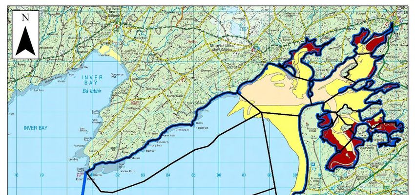
Donegal Bay SPA: Sanderling monitoring - 2014/15
 Marine Institute

List of Tables

Table 2.1    Sanderling counts in Donegal Bay from previous studies.
Table 2.2    Distribution of Sanderling in the NPWS baseline waterbird survey of Donegal Bay, 2009/10.
Table 2.3    Distribution of Sanderling in the NPWS baseline waterbird survey of Donegal Bay, 2009/10.
Table 2.4    Sanderling distribution by zones in IWeBS counts of Donegal Bay, 2006/07-2010/11 and 2012/13.
Table 2.5    Sanderling distribution in the Outer Bay zone in IWeBS counts of Donegal Bay, 2006/07-2010/11 and
             2012/13.
Table 2.6    Distribution of Sanderling in partial census counts of Donegal Bay, Jan-March 2013.
Table 4.1    Sanderling census count dates and associated details in Donegal Bay in 2014/15.
Table 4.2    Numbers and distribution of Sanderling recorded in each subsite during monitoring within Donegal Bay SPA
             in 2014/15.
Table 4.3    Sanderling trestle watch dates and associated details in Donegal Bay in 2014/15.
Table 4.4    Total counts for Sanderling within Donegal Bay SPA in 2014/15 during the trestle Table 5. 1 - Frequency
             occurrence, duration of occurrence & peak number of Sanderling that were observed foraging within the
             areas identified as aquaculture application and licence areas in Donegal Bay.

List of Figures

Figure 1.1    Location of licence application being considered.
Figure 2.1    Donegal Bay & Durnesh Lough SPAs (copy of Figure 1.1 from the AA).
Figure 2.2    Waterbird monitoring subsites in Donegal Bay (Outer Bay) (copy of Figure 3.1. from the AA).
Figure 2.3    Waterbird monitoring subsites in Donegal Bay (Inner Bay) (copy of Figure 3.2. from the AA).
Figure 2.4    Zones used for broad-scale analysis of waterbird distribution (copy of Figure 3.3. from the AA).
Figure 3.1    Census study area with location of vantage points and transects.
Figure 3.2    Trestle watch vantage point with licence areas and existing trestle locations.
Figure 4.1    Location of Sanderling flocks recorded during census in Donegal Bay (Aughrus Pt. – Tallan Strand).
Figure 4.2    Location of Sanderling flocks recorded during census in Donegal Bay (Rossnowlagh / Inishfad).
Figure 4.3    Location of Sanderling flocks recorded during census in Donegal Bay (Murvagh).
Figure 4.4    Location of Sanderling flocks recorded during census in Donegal Bay (Eddrim Estuary).
Figure 4.5    Location of Sanderling flocks recorded during census in Donegal Bay (Mountcharles).
Figure 5.1    Distribution of biotopes in relation to the waterbird monitoring subsites (Figure 6.1 from the AA).
Figure 5.2    Biotope classifications of Donegal Bay (copy of Figure 3 of Aquafact, 2010).

List of Text Figure
Text Figure 2.1 Relationship between the number of complete counts each winter and Sanderling population estimates
                (as indicated by the maximum count and the unsmoothed index values) each winter in the IWEBS
                dataset, 1995/96-2010/11 and 2012/13.

 2927_Dg25_Donegal Monitoring_2014-15.docx                                                                             iii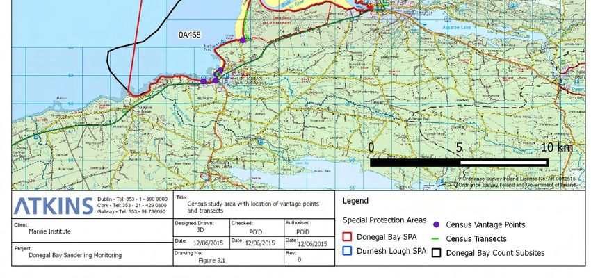
Donegal Bay SPA: Sanderling monitoring - 2014/15
    Marine Institute

1.              Introduction
                Brief & Context
1.1             Atkins (Ecology) was commissioned by the Marine Institute to provide ornithological services in
                relation to the appropriate assessment of aquaculture and shellfisheries on coastal Special
                Protection Areas (SPAs).

1.2             In 2013, Atkins (Ecology) prepared an Appropriate Assessment of aquaculture on the Donegal Bay
                SPA (site code 004151) and a risk assessment of fishing activities in the Inner Bay. Durnesh Lough
                SPA (site code 004145) was also considered in this report, because of its close proximity to the
                Donegal Bay SPA, and the interchange of birds between the two SPAs (Marine Institute, 2013)1.

1.3             As part of the preparation of the 2013 assessment, a need for further data on Light-bellied Brent
                Goose (Branta bernicla hrota) and Sanderling (Calidris canutus) was identified, as previous work
                (Gittings and O’Donoghue, 2012) indicated that both species could be negatively affected by
                intertidal oyster culture, but there were limitations to the available data on their distribution and
                habitat usage in Donegal Bay. In addition, the precise nature of the response of Light-bellied Brent
                Goose to intertidal oyster culture was not clear from the previous work at the time. Therefore, a
                short study of Light-bellied Brent Goose and Sanderling distribution and habitat usage in the main
                areas occupied by intertidal oyster trestles was carried out between January to March 2013 (refer
                to Appendix B of the Donegal Bay SPA Appropriate Assessment; Marine Institute, 2013).

1.4             The Appropriate Assessment report (Gittings and O’Donoghue, 2013) concluded that there was
                potential for intertidal oyster culture in the Mountcharles area to cause sizeable displacement
                impacts to Sanderling, but that there was insufficient data on Sanderling distribution and abundance
                to assess whether these displacement impacts would be significant in terms of the attributes defined
                for the conservation objectives of the Donegal Bay SPA.
1.5             Following the publication of the Appropriate Assessment of aquaculture in the Donegal Bay SPA in
                2013, National Parks and Wildlife Service (NPWS) noted (in their submission) that the assessment
                had stated that some displacement of Sanderling by the existing oyster trestles had probably
                already occurred and as a result, the overall numbers within the Mountcharles/Eddrim Estuary area
                may have been reduced. NPWS were concerned that a further extension of oyster trestle activity in
                this area may well displace the existing Sanderling that use this area further. The assessment put
                this displacement at up to 10% of Sanderling by oyster trestle culture and so was in conflict with
                Sanderling achieving the relevant conservation objective in Donegal Bay SPA. Consequently,
                further information was requested to increase confidence levels in the predicted impact on
                Sanderling in Donegal Bay.

1.6             As a result, an additional period of monitoring for Sanderling in Donegal Bay was proposed from
                September 2014 to February 2015. This report details the methodology, results and conclusions of
                this monitoring period. It also presents a summary of all relevant data sources on Sanderling in
                Donegal Bay.

1 The assessment can be viewed in full at -
https://www.agriculture.gov.ie/media/migration/fisheries/aquacultureforeshoremanagement/aquaculturelicensing/donegalbay/AnnexIIDo
negalBay180713250614.pdf

    2927_Dg25_Donegal Monitoring_2014-15.docx                                                                                  1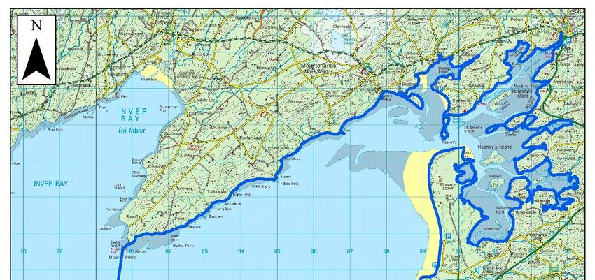
Donegal Bay SPA: Sanderling monitoring - 2014/15
 Marine Institute

             Objectives
1.8          To summarise, the aims of this monitoring were two-fold: -

             •      To attempt to provide an accurate figure for Sanderling populations in Donegal Bay. This figure
                    was to be used to provide a reference level against which the significance of the displacement
                    impact was to be assessed; and

             •      To observe Sanderling behaviour within the Mountcharles/Eddrim Estuary subsites within
                    Donegal Bay to determine if an impact on Sanderling distribution and habitat use due to
                    intertidal oyster culture is observed.

1.9          More specifically, the focus of the assessment is to investigate the potential impact of oyster
             cultivation on Sanderling at plots T12/396A and T12/446A (see Figure 1.1).

                         Figure 1.1 – Location of licence application being considered (T12/396A / T12/446A).

             Acknowledgements
1.10         We are grateful to Lee McDaid, National Parks and Wildlife Service for providing site data and for
             providing information about Sanderling activities in Donegal Bay. Thanks also to Francis O’Beirn
             (Marine Institute); Olivia Crowe (BirdWatch Ireland; IWeBS Office) and David Tierney (NPWS) for
             ongoing assistance with the Marine Institute bird studies.

             Personnel
1.11         The 2014/2015 survey design, analysis and report writing was carried out by Paul O’Donoghue with
             the assistance of John Deasy and Mike Trewby. The fieldwork was carried out by Mike Trewby.
             Data entry and mapping was carried out by Mike Trewby and John Deasy. The report was further
             reviewed by Mike Trewby and Tom Gittings.

 2927_Dg25_Donegal Monitoring_2014-15.docx                                                                      2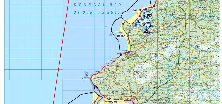
Donegal Bay SPA: Sanderling monitoring - 2014/15
Marine Institute
2. Review of Existing Data
Introduction
2.1 The Appropriate Assessment report (Gittings and O’Donoghue, 2013) examined a range of data
sets and undertook a number of consultations including with John Cromie, co-ordinator of IWeBS
counts for Donegal Bay and Emmett Johnston, NPWS local conservation ranger in order to gain an
understanding of the numbers and distribution of Sanderling in Donegal Bay. This information is
summarised below.
Sanderling
2.2 Sanderling is a small Calidris wader which breeds in high Arctic tundra of eastern Canada,
Greenland and Siberia and winters in coastal areas, particularly on sandy beaches. Donegal Bay is
listed by Boland and Crowe (2012) as a nationally important site for Sanderling.
2.3 During the non-breeding season Sanderling feed on a range of marine invertebrates, mainly
polychaetes, molluscs, small crustaceans as well as insects. The polychaete Scoplelepis squamata
has been found to be an important prey item in parts of NW Europe; as have small bivalves (such
as Donax sp.) as well as shrimp (Crangon crangon); opportunistic feeding on kelp flies, on razorshell
(Ensis sp.) washed ashore and even mussel shells left by feeding Oystercatcher has also been
noted (from Reneerkens et al., 2009).
2.4 In previous work, Gittings and O’Donoghue (2012) reported a negative association between
Sanderling and intertidal oyster trestles. However, the data for Sanderling in this study was limited
and the reported association was based on the position of Sanderling in ordination analyses, rather
than the more detailed analyses of species distribution that were possible for some other species.
Nevertheless, in the extensive study component of Gittings and O’Donoghue (2012), a total of 524
Sanderling were recorded on 14 counts across four sites and there were only two records, each of
single birds, within areas of oyster trestles.
2.5 In the trestle watch study carried out in 2013, there were ten separate observations of flock positions
within the Mountcharles/Eddrim Estuary area. Sanderling were never recorded within the oyster
trestle blocks and the pattern of distribution of the Sanderling flocks is suggestive of Sanderling
avoiding the trestles. However, because of the low total number of observations of Sanderling
flocks, the dataset does not have sufficient statistical power to demonstrate significant avoidance of
the trestle blocks: the probability of all nine flock positions not occurring within the trestle blocks, if
they were selecting habitat at random, would have been around 23%. Nevertheless, the data from
this study adds to the evidence from the previous work by Gittings and O’Donoghue (2012) for
Sanderling showing strong avoidance of oyster trestles. Therefore, for the purposes of this
assessment, we have assumed that intertidal oyster cultivation causes complete exclusion of
Sanderling from the area occupied by the trestles.
Subsites
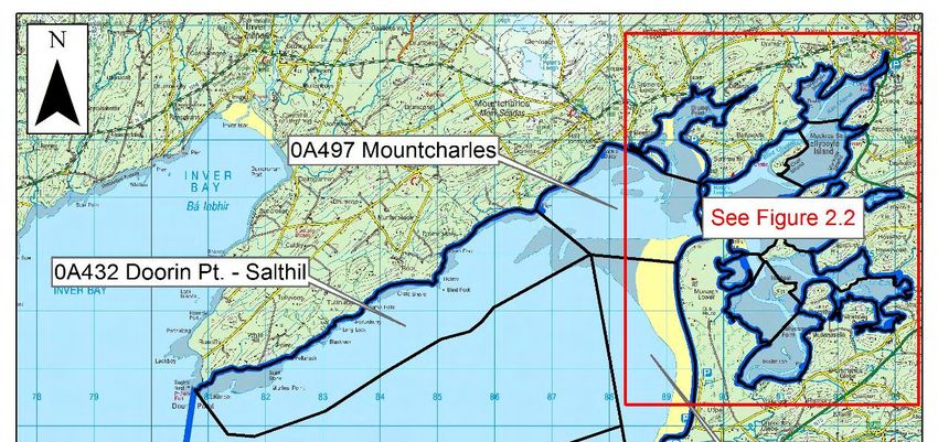
2.6 The boundaries of Donegal Bay SPA are shown in Figure 2.1.
2.7 Donegal Bay has been divided into 19 subsites for the purposes of waterbird monitoring (Figure 2.1
and Figure 2.2). The same subsites were used for both the IWEBS and the NPWS baseline
waterbird survey counts, with the exception of Creevy Pier-Kildoney Point, which was not included
in the NPWS baseline waterbird survey. The subsites cover most of the shoreline of the SPA, with
2927_Dg25_Donegal Monitoring_2014-15.docx 3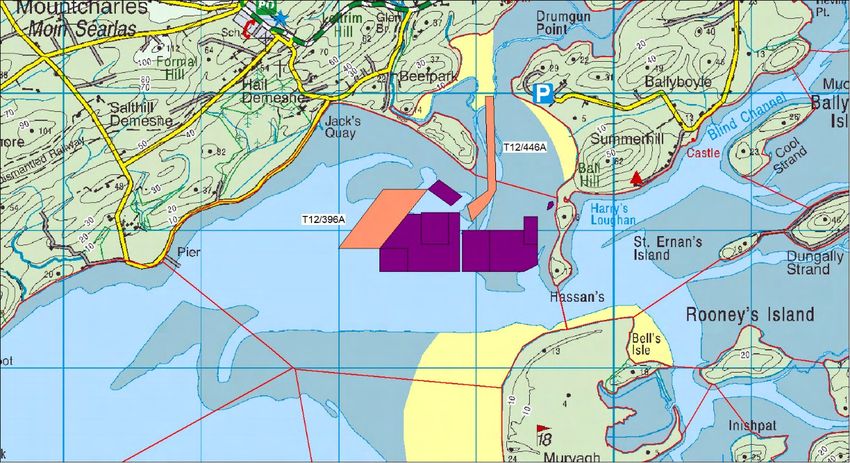
Donegal Bay SPA: Sanderling monitoring - 2014/15
 Marine Institute

             the exception of a section of shoreline between Rossnowlagh and Kildoney and another short
             section of shoreline at the northern side of the mouth of the Erne Estuary. There are large areas of
             offshore subtidal habitat which are not included in any of the subsites; these areas are not, however,
             relevant to Sanderling. As some of the early IWeBS counts used different arrangement of subsites,
             our analyses are based mainly on recent IWeBS data, which uses the subsites discussed above.

2.8          For the purposes of analysing waterbird distribution at a broader scale, the subsites have been also
             grouped into three broad zones: the Outer Bay, the Inner Bay and the Southern Bay (Figure 2.4).

 2927_Dg25_Donegal Monitoring_2014-15.docx                                                                      4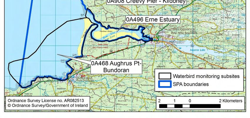
Donegal Bay SPA: Sanderling monitoring - 2014/15
Marine Institute

                       Figure 2.1 – Donegal Bay & Durnesh Lough SPAs (copy of Figure 1.1 from the AA).

2927_Dg25_Donegal Monitoring_2014-15.docx                                                                5
Donegal Bay SPA: Sanderling monitoring - 2014/15
Marine Institute
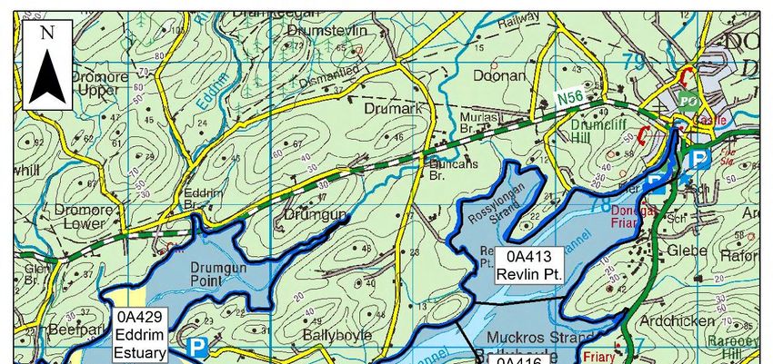
Figure 2.2 – Waterbird monitoring subsites in Donegal Bay (Outer Bay) (copy of Figure 3.1. from
the AA).
2927_Dg25_Donegal Monitoring_2014-15.docx 6Donegal Bay SPA: Sanderling monitoring - 2014/15
Marine Institute
Figure 2.3 - Waterbird monitoring subsites in Donegal Bay (Inner Bay) (copy of Figure 3.2.
from the AA).
2927_Dg25_Donegal Monitoring_2014-15.docx 7Donegal Bay SPA: Sanderling monitoring - 2014/15
Marine Institute
Figure 2.4 – Zones used for broad-scale analysis of waterbird distribution (copy of Figure 3.3.
from the AA).
2927_Dg25_Donegal Monitoring_2014-15.docx 8Donegal Bay SPA: Sanderling monitoring - 2014/15
Marine Institute
Distribution & numbers within Donegal Bay
2.9 As noted, we consulted with the local IWeBS co-ordinator in order to gain an overview of Sanderling
usage of Donegal Bay. Within the bay the main areas which Sanderling tend to use have been
described as the sandy shoreline west and south of the Beefpark peninsula (Mountcharles subsite);
the sandflats at the northern end of Murvagh around the boundary between the Murvagh and
Mountcharles subsites; and the upper shore in the Murvagh subsites, with some also in the
Rossnowlagh subsite (John Cromie, pers. comm.).
2.10 Waterbird distribution has been monitored as part of the Irish Wetland Bird Survey (IWEBS) each
winter since 1995/96. The IWEBS scheme aims to carry out monthly counts each winter between
September and March in all sites that are important for non-breeding waterbird populations.
However, this level of coverage is not always possible to achieve in a volunteer-based scheme. At
Donegal Bay, between one to four complete (or nearly complete) counts have been carried out each
winter, apart from 2001/02 (when no counts were carried out). The level of coverage has increased
in recent years with only one count in most winters prior to 2004/05 and two-four counts in the
winters from 2004/05. Most counts have been carried out in the mid-winter period (December-
February). The counts are carried out by a coordinated team of six volunteers, normally within a
period of 1-2 days. Table 2.1 summarises IWeBS count data from 2006/07 to 2013/14 across each
month (from September to February); counts from Atkins 2012/13 monitoring survey, which was
undertaken in the months of January to March 2013 are also presented.
Table 2.1 – Sanderling counts in Donegal Bay from previous studies.
Season Source Sep Oct Nov Dec Jan Feb Mar
2006/07 IWeBS - - 52 87 26 0 -
2007/08 IWeBS - - - 48 0 - -
2008/09 IWeBS 0 107 - 33 42 - -
IWeBS - - - 21 57 - -
2009/10
BWS 1 - 109 52 271 271 130 -
2010/11 IWeBS - - - 195 205 - -
2012/13 IWeBS 72 14 - 31 1 254 -
2013/14 IWeBS - 68 123 5 96 - -
Atkins
Monitoring
2012/13 - - - - 51 224* 38
Survey
(2013)
* Note: maximum of three counts: 210, 44 and 224.
1
BWS; NPWS baseline waterbird survey 2009/2010.
2.11 The conservation condition and trend of the non-breeding Sanderling at Donegal Bay is summarised
in Table 2.2 (derived from IWeBS data). As can be seen the conservation status of Sanderling in
Donegal Bay is Favourable; the population has grown by +28 in the 5 year period 2003-2008 and
+186.6 in the 12 year period 1994/95 to 2008/09. However, Sanderling is notoriously difficult to
count during high-tide IWeBS surveys. Furthermore, for Sanderling, poor coverage in some years
of the long-term dataset and a resulting relatively high level of data imputation during the indexing
and trend analysis leads to some caution being necessary when examining the trend for this
species. Our analysis of the recent IWEBS data shows that there are large month-to-month
variations in total numbers recorded on counts and it is likely that many of the counts miss significant
2927_Dg25_Donegal Monitoring_2014-15.docx 9Donegal Bay SPA: Sanderling monitoring - 2014/15
Marine Institute
numbers of Sanderling. It is possible that increased coverage in recent winters has biased the trend
analysis: as the number of counts increase it is more likely that at least one count will manage to
be reasonably accurate (i.e. will not miss significant numbers of Sanderling). In fact, there appears
to be a correlation between the number of complete counts2 and the peak Sanderling count and
with the unsmoothed index values3 (Text Figure 2.1), supporting our interpretation.
Table 2.2 – Conservation condition and population trends of non-breeding waterbird SCI species at
Donegal Bay.
Special Site 12 year site 5 year site Current all- Current
Conservation Conservation population population Ireland international
Interests (SCIs) Condition trend1 12YRb trend2 5YR Trend3 trend4
Sanderling Favourable +186.6 +28.0 +109.4 Stable
Source: Tables 4.2 and 4.3 in NPWS (2012b)
N/c = not calculated. 1site population trend analysis, 12 yr. = 1996–2008; 2 site population trend analysis, 5 yr = 2003–
2008; 3 all-Ireland trend calculated for period 1994/95 to 2008/09; 4 international trend after Wetland International (2006);
4
trend based on two five year averages.
Text Figure 2.1 – Relationship between the number of complete counts each winter and Sanderling
population estimates (as indicated by the maximum count and the unsmoothed index values) each
winter in the IWEBS dataset, 1995/96-2010/11 and 2012/13.
2.12 Details of the NPWS baseline waterbird survey (BWS) methodology and results at Donegal Bay
are described in Cummins and Crowe (2010) and NPWS (2012b). Distribution of Sanderling across
subsites in Donegal Bay during the 2009/10 NPWS baseline waterbird survey are presented in
Table 2.3. While the weather over 2009/10 was very cold Sanderling has been found in the
2Where a complete count is defined as including the main subsites that are important for Sanderling (see paragraphs 2.2-2.22).
3Unsmoothed index values were read off the graph on page 11 of NPWS (2012); no index values were available for the winters since
2009/10.
2927_Dg25_Donegal Monitoring_2014-15.docx 10Donegal Bay SPA: Sanderling monitoring - 2014/15
Marine Institute
Waddensea to be the only wader that does not show differences in numbers between cold and mild
winters (from Reneerken et al., 2009); it is likely therefore that the results are not cold-weather
influenced as can happen with some waders.
2.13 In the NPWS baseline waterbird survey counts, Murvagh was the only subsite that held Sanderling
on all the counts. NPWS (2012) notes that, within the Murvagh subsite, Sanderling “appeared to
favour foraging within an area on the lower shore in the north of the subsite, the birds positioned in
roughly the same area in all four low tide counts, usually accompanied by Dunlin, Bar-tailed Godwits
and Oystercatchers amongst other species, with flocks often overlapping with subsites 0A497 and
0A432” (i.e. Mountcharles and Doorin-Salthill). The Erne Estuary held Sanderling on three of the
five counts and the Eddrim Estuary held Sanderling on two of the five counts. No Sanderling were
recorded in the Inner Bay subsites (apart from the Eddrim Estuary).
Table 2.3 – Distribution of Sanderling in the NPWS baseline waterbird survey (BWS) of Donegal Bay,
2009/10.
21 Oct 04 Nov 02 Dec 07 Feb 17 Feb
Subsite
LT LT LT HT LT
Aughrus Pt – Bundoran
0 0 35 0 0
(Southern Bay)
Erne Estuary (Southern Bay) 46 0 160 170 0
Eddrim Estuary (Outer Bay) 0 0 2 35 0
Murvagh (Outer Bay) 63 51 74 66 130
Rossnowlagh (Outer Bay) 0 1 0 0 0
Total 109 52 271 271 130
See Figure 2.2 and 2.3 for subsite locations).
2.14 As noted, in the Appropriate Assessment we further divided Donegal Bay divided into Inner, Outer
and Southern sectors (see Figure 2.4 for zones). In the IWeBS counts, most Sanderling were found
to occur within the Outer Bay zone, with significant numbers also occurring, but less frequently in
the Southern Bay zone (Table 2.4). Most counts were carried out on rising or falling tides.
2.15 The distribution of birds between subsites is not very consistent across IWeBS counts. However,
on most counts, the majority of birds were distributed across the subsites in the middle of the Outer
bay: i.e. Murvagh (0A479), Rossnowlagh – Inishfad (0A489) and Rossnowlagh (0A464) (see Table
2.4). Sanderling were recorded from the Mountcharles subsite on three counts. There were only
two count from the Inner Bay. The distribution of birds within different parts of the Outer Zone is
summarised in Table 2.5; again Murvagh to Rossnowlagh emerges as important, though flocks do
occur elsewhere such as in Mountcharles.
2927_Dg25_Donegal Monitoring_2014-15.docx 11Donegal Bay SPA: Sanderling monitoring - 2014/15
Marine Institute
Table 2.4 – Sanderling distribution by zones in IWeBS counts of Donegal Bay, 2006/07-2010/11 and
2012/13 (refer to Figure 2.4 for zones).
Winter Month Southern Bay Inner Bay Outer Bay Total
Nov 52 52
2006/07 Dec 23 65 87
Jan 22 3 26
2007/08 Dec 28 20 48
Oct 107 107
2008/09 Dec 1 32 33
Jan 25 9 8 42
Dec 17 4 21
2009/10
Jan 57 57
Dec 195 195
2010/11
Jan 48 157 205
Sep 52 20 72
Oct 14 14
2012/13 Dec 31 31
Jan 1 1
Feb 254 254
Oct 67 1 68
Nov 20 103 123
2013/14
Dec 5 5
Jan 33 63 96
2927_Dg25_Donegal Monitoring_2014-15.docx 12Donegal Bay SPA: Sanderling monitoring - 2014/15
Marine Institute
Table 2.5 – Sanderling distribution in the Outer Bay zone in IWeBS counts of Donegal Bay, 2006/07-
2010/11 and 2012/13.
Doorin Pt. - Murvagh- Donegal Bay
Winter Month Mountcharles
Salthill Pier Rossnowlagh total
Nov 52 52
2006/07 Dec 65 87
Jan 3 26
2007/08 Dec 20 48
Oct 107 107
2008/09 Dec 1 31 33
Jan 8 42
Dec 4 21
2009/10
Jan 57 57
Dec 195 195
2010/11
Jan 2 155 205
Sep 20 72
Oct 14 14
2012/13 Dec 31 31
Jan 1 1
Feb 6 248 254
Murvagh-Rossnowlagh represents the combined count across the Murvagh (0A479), Rossnowlagh-Inishfad (0A480) and
Rossnowlagh subsites (0A464). Counts in italics were at high tide, counts in bold were at low tide; all other counts were
on rising or falling tides. For Murvagh-Rossnowlagh, where counts were not all carried at the same tidal states in these
subsites, the count is classified according to the tidal state in the subsite(s) with the majority of the count.
2.16 The distribution of Sanderling during the Atkins partial census counts in January-March 2013 is
shown in Table 2.6. These counts did not cover the Inner Bay, while coverage of some of the more
extensive outer sandflats, such as Murvagh, was probably limited. The largest Sanderling flocks
were recorded in the Aughrus Pt – Bundoran subsite on the two counts. Looking across both the
2013 trestle watch and census counts, Sanderling occurred in the Eddrim Estuary/Mountcharles
area (0A497) on four of the five count days.
2927_Dg25_Donegal Monitoring_2014-15.docx 13Donegal Bay SPA: Sanderling monitoring - 2014/15
Marine Institute
Table 2.6 – Distribution of Sanderling in partial census counts of Donegal Bay, Jan-March 2013.
Subsite 11 Jan 29 Jan 03 Feb 12 Feb 25 Feb 12 Mar
Mountcharles 44 16
Eddrim Estuary 40 10
Murvagh 51 84 12
Census count
Rossnowlagh 38
Aughrus Pt - Bundoran4 126 146
Total 51 210 44 224 38
Trestle watch Eddrim Estuary/ Mountcharles 90 62 63
Other Mountcharles 52
Erne Estuary and Aughrus Pt – Bundoran not covered on 29 Jan 2013; Inner Bay not covered or only partially covered
on all counts. Counts in bold were at low tide; all other counts were on rising or falling tides.
IWebS equivalent areas are as follows: - Mountcharles (0A497); Eddrim Estuary (0A429); Murvagh (0A479);
Rossnowlagh (0A480 & 0A464) and Aughrus Pt – Bundoran (0A468) (see Figure 2.2 & 2.3).
2.17 Overall, while the data indicates that Sanderling distribution across Donegal Bay is highly variable;
there does appear to be three core areas; namely Murvagh – Rossnowlagh, Aughrus Pt – Bundoran
and Mountcharles / Eddrim. Given the large month-to-month variation in total numbers recorded on
counts, and the difficulty of accurately counting a small and highly mobile wader across such a large
site, it seems likely that many of the counts miss significant numbers of Sanderling. It seems
plausible that there is a total midwinter population of around 200-300 birds, in which case, only
counts that record more than 200 are likely to give a good indication of patterns of Sanderling
distribution.
2.18 Excluding the Eddrim Estuary, Sanderling do not seem to favour the Inner Bay; this is in line with
expectations based on biotope and benthic invertebrate data. Therefore, Sanderling distribution
does not overlap to any significant extent with any of the Inner Bay applications or licenses for
intertidal oyster cultivation.
2.19 Available data does suggest that Sanderling do seem to occur with some regularity within the
Mountcharles / Eddrim Estuary area. Therefore, Sanderling distribution does overlap with the
applications and licenses in the Mountcharles subsite.
2.20 In the 2013 census counts and trestle watches, Sanderling were recorded on four of the five survey
days, and were also recorded on a separate reconnaissance visit, with a mean count across these
six days of 48 birds. These were intensive surveys, with the area continuously watched for a period
of over three hours; Sanderling flocks were typically only observed as being present for a short
duration, highlighting the difficulty faced when attempting to census this species and determine its
spatial distribution in Donegal Bay SPA.
2.21 Sanderling were recorded less frequently within the Eddrim Estuary/Mountcharles area in the
IWeBS and NPWS baseline waterbird survey counts. However, in the IWeBS counts, these subsites
were mainly counted on rising or high tides. Most of the NPWS baseline waterbird survey counts
were low tide counts; one of the low tide counts did, however, exceed 200 (i.e., can be considered
4 Both counts from Tullan Strand / Bundoran were early morning counts. It is our experience that birds are unlikely to stay in this area
long as gets busier with walkers later in morning. On 3rd February 2015, the surveyor first picked up 16 Sanderling at 08:00 at Bundoran
Bridge; then a larger flock of 126 birds was recorded on strand at 08:30. On 25th February 2015 the first birds counted – at 07:20 –
associated with roost on beach at Bundoran; these birds commenced foraging before some dispersal from the site occurred.
2927_Dg25_Donegal Monitoring_2014-15.docx 14Donegal Bay SPA: Sanderling monitoring - 2014/15
Marine Institute
likely to accurately reflect Sanderling distribution). As noted, from observations through the years,
the Beefpark peninsula in the Mountcharles subsite has been described as one of the main areas
where Sanderling occur in Donegal Bay (John Cromie, pers. comm.).
2.22 In conclusion, along with the neighbouring Murvagh peninsula, historical data emphasises the
importance of the Eddrim Estuary/Mountcharles area for Sanderling in Donegal Bay. On the basis
of data to 2013 it was estimated that around 25% of the Donegal Bay Sanderling population could
regularly occur within the Eddrim Estuary/Mountcharles area.
2.23 It is obviously not possible to know whether Sanderling occurred within the area now occupied by
trestles, prior to the introduction of the trestles. However, given the pattern of Sanderling distribution
within the Mountcharles/Eddrim Estuary area, the similarity in substrate/biotope between the area
now occupied by trestles and the area where Sanderling now occur, and the location of the trestle
blocks between two areas where Sanderling regularly occur (the Mountcharles/Eddrim Estuary area
and the Murvagh sandflats), it was concluded at the time that it is reasonable to assume that
Sanderling would have occurred within the area now occupied by trestles, prior to the introduction
of the trestles.
2.24 BirdWatch also co-ordinate a Non-Estuarine Waterbird Survey (Crowe et al. 2012) around the
Irish coast. Substantial proportions of the overall national populations of a number of species,
including Sanderling were found to occur along non-estuarine coasts. In the case of Sanderling 51%
of non-estuarine sectors counted included Sanderling in the 2006/07 census, with highest densities
/ km from west, southeast and east coasts. Summers et al. (2002) in a review of site preferences of
waders on the Orkneys found that Sanderling preferred wide, sandy shores.
2.25 There is an extensive non-estuarine coastline both to the south and west of Donegal. With respect
availability of wide sandy beaches close to Donegal Bay SPA; the nearest are as follows. To the
west Inver Bay has a large sandy beach / estuary at the head of the bay. To the south a number of
wide beaches are also present to the southwest of Bundoran; i.e. Bunduff Strand and Trawlua
Strand (either side of Mullaghmore). These are all within ca. 10km of Donegal Bay. The degree of
interchange between Donegal & Inver or Tullan Strand / Bundoran and Bunduff Strand / Trawlua
Strand is not known; generally, however, Sanderling are viewed as quite site faithful.
2927_Dg25_Donegal Monitoring_2014-15.docx 15Donegal Bay SPA: Sanderling monitoring - 2014/15
Marine Institute
3. Methods
Survey area
3.1 The study area for the Sanderling census counts in 2014/15 was the intertidal area of the Outer bay
and Southern bay zones of Donegal Bay (Figure 3.1).
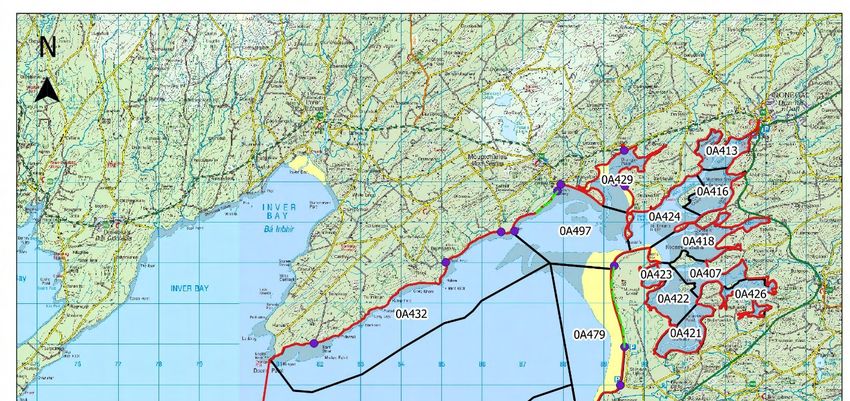
3.2 The study area for the trestle watch surveys in 2014/15 was confined to the subsites within which
existing licences or applications for licences to culture oyster are located. These included the
Mountcharles subsite (OA497) to the west of Hassan’s where the majority of oyster trestles are
located. There is a current application to extend this block further to the west (T12/396A), with a
second to the northeast (T12/446A) of existing trestles in Mountcharles (Figure 1.1). Oyster trestles
occurring to the east of Hassan’s in the St. Ernan’s Island and Dungally Strand subsites (OA418
and OA424) were not monitored during the trestle watch survey as previous datasets and monitoring
has shown that Sanderling distribution does not overlap with applications or licenced intertidal
cultivation areas in the inner bay, except the Eddrim estuary subsite.
Census Counts
3.3 Monthly low tide counts of Sanderling throughout the intertidal area of the Outer bay and Southern
bay zones of Donegal Bay (Figure 3.1) were undertaken between September 2014 and February
2015, inclusive.
3.4 Counts were undertaken using a combination of vantage point and transects to cover the study
area. The positions of these vantage points and transects were recorded on aerial photography.
Data recorded during surveys included the number of birds in each Sanderling flock, the position of
the flocks, their activity i.e. feeding or roosting/other and the habitats used by the birds (original data
available on request).
3.5 All the 2014/15 censuses started at Bundoran typically on a falling tide and sometimes at dawn to
target the roosting site identified in 2013. The Bundoran roost was also visited at dawn on other
dates separate to the census to better understand the pattern of roosting and dispersal from this
site; survey dates included: -
• 20th October 2014;
• 2nd December 2014;
• 6th December 2014;
• 8th December 2014; and
• 23rd January 2015.
3.6 From Bundoran the observer moved north through Donegal Bay, systematically walking the transect
routes or surveying from the vantages points, generally reaching Murvagh Strand during the period
around low tide and then moving around to the Eddrim Estuary, Jack’s Quay and Salthill Pier. Initially
(i.e. September to November) Murvagh Strand and the sand bar stretching west off the northern
end of the dunes was only covered around low tide. However, faced with repeated low sanderling
counts for Donegal Bay, the area was covered twice from December onwards, with the first sweep
of the area undertaken during low tide and then a second sweep undertaken at the end of the survey
2927_Dg25_Donegal Monitoring_2014-15.docx 16Donegal Bay SPA: Sanderling monitoring - 2014/15
Marine Institute
day. The observer would walk the length of Murvagh Strand to try and gauge whether any sanderling
were being pushed along the sandbar by the rising tide or if they were moving into the area from
other locations.
3.7 For the January and February censuses the 0A432 (Doorin Pt.-Salthill) sub-site was not surveyed
in full. Due to the consistent lack of birds in this area, a decision was made to drop the Burnfoot to
Murles Point (Doorin Point) part of this sub-site to allow for more time surveying the Murvagh /
Mountcharles / Eddrim area for sanderling. The decision was justified, as the outer parts of 0A432
do not hold typical sanderling foraging habitats and birds have not been or are very rarely recorded
in this area.
2927_Dg25_Donegal Monitoring_2014-15.docx 17Donegal Bay SPA: Sanderling monitoring - 2014/15
Marine Institute
Figure 3.1 – Census study area with location of vantage points and transects.
2927_Dg25_Donegal Monitoring_2014-15.docx 18Donegal Bay SPA: Sanderling monitoring - 2014/15
Marine Institute
Trestle watches
3.9 The monitoring was undertaken from a vantage point on Hassan’s (Figure 3.2). This is a small
peninsula that separates the Mountcharles and St. Ernan’s Island subsites. The northernmost of
the two small hills on this peninsula provided a good vantage point for surveying the oyster trestle
areas and adjoining application areas across a full low tide period, i.e. from the time that the trestles
became exposed on the receding tide to the time that the trestles were fully covered on the flooding
tide.
3.10 During the monitoring period, the surveyor scanned subsites 0A429 (Eddrim Estuary) and 0A497
(Mountcharles) and the visible areas of other subsites at 10 minute intervals. Any Sanderling
detected were recorded. For each detection, the surveyor recorded the following information: -
• the location of the bird(s);
• the subsite in which they occur;
• the habitat in which they occur;
• the time of the initial detection;
• the time of the final detection;
• the number of birds; and
• their activity (feeding or roosting/other).
3.11 The habitat classes used in the monitoring were either; mud/sandflat within the oyster trestles;
mud/sandflat outside of the oyster trestles or mixed sediment. Birds in lanes between trestle blocks
were recorded within the appropriate ‘within oyster trestles’ category. The mixed sediment habitat
is the habitat that occurs along shoreline areas.
3.12 The position of the tideline in subsites 0A429 and 0A497 was sketched at 30 minute intervals.
3.13 Records were kept of the timing and intensity of husbandry activity within the trestle blocks.
Additional information on other activities such as recreational use and boat activity were also noted
along with weather conditions and any other observations.
3.14 Census and trestle watch counts were undertaken by one counter using a 8 x 40 binoculars and
spotting scope with 25 to 60 x zoom.
Limitations to this study
3.15 During the trestles watches changing weather conditions over the course of a survey day resulted
in sub-optimal visibility over more distant parts of the study area at times. Deterioration in visibility
due to a passing shower or glare was accounted for while surveying and data collected during
periods of compromised visibility were excluded from the data set.
3.16 During sanderling censuses of Donegal Bay the potential for Sanderling movement within the bay
over a survey day was not fully accounted for. There is a risk that single surveyor moving through
a large site like Donegal Bay could be picking up the same birds as they shift to different foraging
and roosting locations within the study area. During the course of this study two core Sanderling
foraging areas have emerged, one at Murvagh Strand/Eddrim Estuary and the other on Tullan
2927_Dg25_Donegal Monitoring_2014-15.docx 19Donegal Bay SPA: Sanderling monitoring - 2014/15
Marine Institute
Strand to the north of Bundoran. While there was probably interchange of birds between these
areas, it was felt that on census days when flocks were recorded in both areas, these were different
birds. To exclude this uncertainty, the two core sanderling foraging areas would have to be counted
simultaneously to conclusively determine that the both location were occupied by different flocks.
2927_Dg25_Donegal Monitoring_2014-15.docx 20Donegal Bay SPA: Sanderling monitoring - 2014/15
Marine Institute
Figure 3.2 – Trestle watch vantage point with licence areas and existing trestle locations.
2927_Dg25_Donegal Monitoring_2014-15.docx 21Donegal Bay SPA: Sanderling monitoring - 2014/15
Marine Institute
4. Results
Low tide census counts
Count dates, timings and weather conditions
4.1 A total of six census counts were undertaken in Donegal Bay SPA from September 2014 to February
2015. The count dates, timings, tide times and weather conditions for surveys are shown in Table
4.1.
Table 4.1 – Sanderling census count dates and associated details in Donegal Bay in 2014/15.
Start End Wind Cloud Temp
Date HW LW Wind Rain Visibility
Time Time Dir. (%) (°C)
26/09/2014 10:39 16:46 - 13:42 F4 W None Good 50 15
25/10/2014 11:57 17:09 - 13:20 F4 SW None Good 90 13
14:40 Show
22/11/2014 08:16 - 11:27 F3 SW Good 90 9
ers
Good to
Moderate
09/12/2014 08:37 16:43 07:13 13:18 F6 W None (Sea mist 100 10
& low
light)
Show Moderate
23/01/2015 07:50 17:25 07:34 13:42 F3 WSW 100 6
ers (Low light)
04/02/2015 09:02 16:32 06:05 12:07 F3 NNW None Good 50 6
Note: Wind speed – Beaufort.
2014/15 Census – Number of Sanderling
4.2 The overall total Sanderling recorded for each census survey in Donegal Bay SPA are shown in
Table 4.2.
Table 4.2 – Numbers and distribution of Sanderling recorded in each subsite during monitoring
within Donegal Bay SPA in 2014/15.
Subsite Number 26/09/14 25/10/14 22/11/14 09/12/14 23/01/15 04/02/15
NW of Durnesh Lake 0A480 9* - - - - -
Bundoran and Tullan Strand 0A468 - - - 77 15 56
Murvagh Strand 0A479 25 5 37 55 40 -
0A497/
Mountcharles/Eddrim Estuary - - - - - 47
0A429
Total 25 1 5 37 2 132 45 103
* Denotes that this Sanderling flock were observed briefly settling at this location before flying out of sight soon after and
were possibly part of the flock observed in Murvagh Strand.
1
There may have been a maximum count of 31 birds (risk of double counting); 2 There may have been a maximum count
of 43 birds (risk of double counting);
4.3 The distribution of Sanderling flocks recorded for each census survey in Donegal Bay SPA are
shown in Figure 4.1. The peak number of Sanderling recorded in Donegal Bay during low tide
2927_Dg25_Donegal Monitoring_2014-15.docx 22Donegal Bay SPA: Sanderling monitoring - 2014/15
Marine Institute
census counts in 2014/15 was 132 birds recorded in the December 2014 count. 77 of these birds
were recorded in the Bundoran/Tullan Strand section of Aughrus Point-Bundoran subsite (0A468)
and 55 at Murvagh Strand (0A479). Another high count of 103 birds was made during the February
count. In the latter case this included 47 birds at Mountcharles / Eddrim Estuary (0A497 / 0A429).
4.4 This peak count for the 2014/15 monitoring census is 41% lower than that recorded during the 2013
census monitoring (224 birds on 25th February 2013; see Table 2.1). It appears that this count of
224 was not an exceptionally high count however, as another count of 210 Sanderling was recorded
on the 3rd February 2013.
4.5 The peak count of Sanderling during the NPWS baseline waterbird survey in Donegal Bay,
undertaken in 2009/10, was 271 birds; recorded for both the 2nd December 2009 low tide count and
the 7th February 2010 high tide count.
2014/15 Census – Distribution of Sanderling
4.6 The distribution of flocks recorded during the 2014/2015 census surveys suggests that two subsites
are of particular importance to Sanderling in Donegal Bay, namely the Aughrus Pt – Bundoran
subsite (0A4685) and the Murvagh Strand subsite (0A479). Sanderling were recorded in 50% and
83% of occasions from these subsites, respectively. Sanderling were also recorded on one occasion
in the Rossnowlagh – Inishfad subsite (0A480) and the Mountcharles subsite (0A497). Sanderling
are consistently recorded in the Murvagh Strand subsite (0A479); i.e. 100% of occasions during the
NPWS baseline waterbird surveys, 50% of occasions during 2013 Atkins monitoring surveys; and
is in line with observations by the local IWeBS coordinator (John Cromie, pers. comm.).
4.7 The NPWS baseline waterbird survey only recorded Sanderling occurring in Aughrus Pt – Bundoran
for one low tide count in December 2009. The 2013 Atkins monitoring surveys recorded Sanderling
in Aughrus Pt – Bundoran on two occasions, in relatively large flocks of 126 and 146. Field
observations from this study suggest that the importance of the Aughrus Pt – Bundoran subsite may
be overlooked in other datasets as the Sanderling can leave the roost at this location early in the
morning and so may not be recorded if surveys take place later in the day (M. Trewby, pers comm).
4.8 During the census counts for the current study (2014/2015) Sanderling were only recorded on one
occasion in the Mountcharles subsite; i.e. during the February count; when a flock of 46 Sanderling
were observed foraging on the sandbank south of Beefpark dunes before later flying into Eddrim
Estuary. The results from this study are comparable to those from the Atkins 2013 monitoring
census where again only one flock of 44 Sanderling were observed in the Mountcharles subsite,
foraging southeast of Jacks’ Quay on the 12th February 2013. However, to determine the use of the
subsite by Sanderling and the importance of the habitats to them, it is necessary to investigate the
results of the trestle watch counts. This will be discussed in more detail below.
5 Though strictly speaking Bundoran to Tallan Strand is the key area for Sanderling within this site.
2927_Dg25_Donegal Monitoring_2014-15.docx 23Donegal Bay SPA: Sanderling monitoring - 2014/15
Marine Institute
Trestle watches
Count dates, timings and weather conditions
4.10 A total of five trestle watch counts were undertaken in Donegal Bay SPA from September 2014 to
February 2015. The count dates, timings, tide times and weather conditions for surveys are shown
in Table 4.3. A trestle watch was not completed in October due to adverse weather (high winds)
which it was feared may have been causing low counts.
Table 4.3 – Sanderling trestle watch dates and associated details in Donegal Bay in 2014/15.
Start End LW Wind
Date Wind Rain Visibility Cloud (%) Temp (°C)
Time Time Dir.
29/09/2014 12:45 18:45 15:39 F1 SSE to S None Good 95 to 100 16 to 19
Light
23/11/2014 09:00 15:00 12:01 F0 to 3 N to W Good 50 to 100 3 to 8
drizzle
08/12/2014 09:40 15:40 12:40 F3 to 4 WNW None Good 30 to 70 7
22/01/2015 09:50 16:10 12:59 F0 to 1 SSE to S None Good 5 to 100 1 to 4
05/02/2015 09:30 15:40 12:37 F0 to 2 WNW None Good 60 to 100 4 to 7
4.11 In contrast to the census counts, Sanderling were recorded within the Mountcharles (0A497) subsite
on four of the five trestle watch surveys. No Sanderling were recorded within this subsite on the
29th September 2014. Table 4.4 presents the maximum flock numbers recorded within the
Mountcharles subsite during the trestle watch.
2927_Dg25_Donegal Monitoring_2014-15.docx 24Donegal Bay SPA: Sanderling monitoring - 2014/15
Marine Institute
Table 4.4 – Total counts for Sanderling within Donegal Bay SPA in 2014/15 during the trestle watch
surveys.
Duration
Max. SS
of trestle
Month Date flock Notes
watch
count
(hr:min)
No Sanderling recorded within Mountcharles subsite
September 29/09/2014 6:00 0
during trestle watch.
October - - No trestle watch survey for October.
Sanderling flocks observed off Jack’s Quay and
around the ‘old’ Eddrim channel, immediately north of
the application aquaculture area. Flock pushed up on
rising tide and at one stage (12:42 to 13:09) was
foraging on a thin sand bar that stretches north out of
the licensed area of trestles. The flock was pushed
November 23/11/2014 6:00 38
into the aquaculture application area briefly and as
the tide inundated this sand bar the flock moved north
to exposed sands off between the ‘old’ and ‘new’
Eddrim channels. Then possibly relocated to the
northern end of Murvagh Strand as the sand flats
were covered by the tide
Sanderling flocks initially located south of Jack’s
Quay and moved along the coastline in the direction
December 08/12/2014 6:00 79 of Salthill Pier with some birds moving further south
to forage along the margins of the ‘old’ Eddrim
channel, west of the application aquaculture area.
Flock of 22 Sanderling first observed flying over
trestle area, into Eddrim Estuary and out over the
Beefpark dunes to settle south of Jack’s Quay.
Additional numbers of Sanderling observed here so
probable that Sanderling were already present in this
area when observations commenced. Maximum
count of 74 as the Sanderling flocks moved west
along the coastline. These flocks split and flew south
onto the sandbar between the ‘old’ and new Eddrim
44 but
channel. Sanderling flocks foraged southwest of the
January* 22/01/2015 6:20 possibly
existing trestles, inside both the licenced and
up to 79
application areas. Small Sanderling flock recorded
along small intertidal channel within trestle area.
These flocks move southwest along northern side of
new Eddrim channel before relocating to the sand
flats south of Jack’s Quay and continued to forage
along the rising tide line. Some of the Sanderling flew
to the sand flat south of Beefpark dunes and from
here flew south out of the subsite, possibly to the
north end of Murvagh Strand.
Flock of 20 Sanderling were initially briefly observed
on the sandbank between the ‘old’ and new Eddrim
channel, within the application aquaculture area. This
flock then moved to the northern side of the ‘old’
Eddrim channel and continued to forage in this area
until they were lost from view at 11:40. At 14:11, a
small flock of 5 Sanderling were again briefly
February 05/02/2015 6:10 22
observed on the sandflat south of Beefpark dunes. A
passing shower obscured the flock from the observer
and once the visibility had improved the SS flock
were no longer present. Note that flocks (c. 200) of
unidentified small waders were observed on the
northern end of Murvagh Strand during this trestle
watch.
* Note: Sanderling flock (5) recorded in Inner Eddrim estuary before trestle watch survey was commenced. Flew into inner
estuary out of sight before trestle watch survey began.
2927_Dg25_Donegal Monitoring_2014-15.docx 25Donegal Bay SPA: Sanderling monitoring - 2014/15
Marine Institute
Figure 4.1 – Location of Sanderling flocks recorded during census in Donegal Bay (Aughrus Pt. – Tallan Strand).
2927_Dg25_Donegal Monitoring_2014-15.docx 26Donegal Bay SPA: Sanderling monitoring - 2014/15
Marine Institute
Figure 4.2 – Location of Sanderling flocks recorded during census in Donegal Bay (Rossnowlagh / Inishfad).
2927_Dg25_Donegal Monitoring_2014-15.docx 27Donegal Bay SPA: Sanderling monitoring - 2014/15
Marine Institute
Figure 4.3 – Location of Sanderling flocks recorded during census in Donegal Bay (Murvagh).
2927_Dg25_Donegal Monitoring_2014-15.docx 28Donegal Bay SPA: Sanderling monitoring - 2014/15
Marine Institute
Figure 4.4 – Location of Sanderling flocks recorded during census in Donegal Bay (Eddrim Estuary).
2927_Dg25_Donegal Monitoring_2014-15.docx 29Donegal Bay SPA: Sanderling monitoring - 2014/15
Marine Institute
Figure 4.5 – Location of Sanderling flocks recorded during trestle counts in Donegal Bay (Mountcharles).
2927_Dg25_Donegal Monitoring_2014-15.docx 30Donegal Bay SPA: Sanderling monitoring - 2014/15
Marine Institute
5. Discussion
Sanderling population in Donegal Bay
5.1 The results of the 2014/15 monitoring period combined with the results of previous monitoring
(2013) and other available datasets show that there is a large degree of variability in Sanderling
counts in Donegal Bay; with a large range in results from each census count from month to month.
The 2014/15 census recorded a maximum count of 132 birds using Donegal Bay during the winter
months. While in line with IWeBS counts from recent years, it is lower than recent peak counts in
the 200’s which suggest that overall Donegal Bay probably supports a midwinter population of over
200 and possibly closer to 300 Sanderling.
5.2 In line with previous counts, which generally recordedDonegal Bay SPA: Sanderling monitoring - 2014/15
Marine Institute
5.7 The extent of interchange between Sanderling flocks in the north and south of the bay is not known;
however, observations of flocks, particularly during the trestle watches, clearly indicate that there is
some interchange between the northern end of Murvagh Strand and the Mountcharles/Eddrim
estuary subsite depending on tide conditions. As a result, the small number of observations from
the census surveys of Sanderling underestimate the importance of Mountcharles/Eddrim estuary
subsites for this species.
5.8 Furthermore, field observations also highlight the potential for some uncertainty as to whether birds
also move southwards out of Donegal Bay from roosts near Bundoran / Erne; thus potentially
leading to a discrepancy between high tide and low tide counts within the SPA.
5.9 A further complication in determining the importance of Donegal Bay for Sanderling is linked to the
origin of birds. As noted Sanderling breed in eastern Canada, Greenland and Siberia. In the past it
was believed the birds wintering in Britain and Ireland were of Siberian origin; recent ringing records,
however, clearly demonstrates that Nearctic birds do travel to Ireland. The degree of mixing of birds
from different breeding populations is poorly understood; as is the degree to which birds use Irish
estuaries as spring / autumn migration stopovers rather than as over-wintering sites. This raises the
possibility of turn-over of birds at a site in spring and autumn such that the estuary actually supports
a larger number of birds than counting of unmarked birds would suggest.
Bundoran Roost
5.10 During 2013 a small roosting site used by waders, gulls and Light-bellied Brent Geese was located
at Bundoran on the sandy cove south of Aughrus Point and Rougey Strand. During two of the
February 2013 censuses the Bundoran area was targeted for surveying between dawn and sunrise;
this also coincided with periods close to (within 2 hours of) high tide – either rising (3/02/2013) or
falling (25/02/2013). On both of these dates large flocks of sanderling were recorded; 126 and 146
birds, respectively. While the sanderling flocks were foraging, it was presumed that they had roosted
in the area. The attraction of the area as a high tide night roost might be related to the street lighting
along the promenade which could benefit roosting birds by illuminating approaching predators.
Unfortunately, given the time pressure of having to complete a count of Donegal Bay and then
conduct a trestle watch there was no time to track the onward dispersal of these birds. However, it
likely that disturbance thresholds in this relatively busy area of Bundoran quickly exceed tolerance
levels and birds leave the area. Potential sanderling foraging areas - identified as predominately
sandy beaches or estuaries – are available to the NE of this roosting site on Tullan Strand and the
Erne Estuary, which are within c. 1 km and c. 2.5 km respectively. The coastline to the southwest
of Bundoran is less promising for sanderling, being dominated by low rocky shore with the
occasional shingle beach, until Bunduff Strand at Mullaghmore, which is c. 10 km to the south. It
seems more probable that birds using this area would therefore remain within the Donegal Bay /
Erne area.
5.11 Over winter 2014-15, the Bundoran roosting site was targeted on several occasions at dawn during
October and December 2014. While other species including Oystercatchers, Ringed Plover and
Turnstone were in attendance sanderling were not recorded until a visit on 23rd January 2013 when
just a single bird was recorded.
Sanderling distribution in Mountcharles
5.12 Previous studies into interactions between shorebirds and intertidal aquaculture trestles suggest
that Sanderling strongly avoid oyster trestles (Gittings and O’ Donoghue, 2012). This is supported
by observations from previous trestle watches at Mountcharles in 2013 where 10 separate
observations of flock positions were recorded outside the oyster trestle blocks. In the 2014/15 trestle
watch study, the position of Sanderling flocks mapped during the trestle watch survey indicate that
2927_Dg25_Donegal Monitoring_2014-15.docx 32Donegal Bay SPA: Sanderling monitoring - 2014/15
Marine Institute
Sanderling were rarely recorded with the existing trestle blocks, with only one record of a flock of c.
8 birds (possibly an underestimation as 20 birds were seen leaving the area soon after) recorded in
an open area between the trestle blocks (Figure 4.5).
5.13 All other observations in this study indicate that the majority of Sanderling flocks were mainly
distributed in an area of intertidal muddy sand to sand biotope south of Jack’s Quay and along the
margins of the ‘old’ Eddrim channel that runs to the northwest of the licence and application
aquaculture areas (Figure 4.5). NPWS biotope mapping is derived from the OSi Discovery Series
mapping; the distribution of available intertidal habitat has, however, changed significantly. Thus,
for example, flocks of Sanderling noted to the south of the existing Mountcharles trestles (T12/243B
& T12/145B) appear on NPWS biotope mapping to be in subtidal habitat, but are in fact availing of
a narrow band of suitable intertidal habitat; care must therefore be taken in interpreting their spatial
distribution here as evidence of tolerance of trestles as opposed to a need to avail of a narrow band
of available habitat within a narrow tidal window. It can’t be known for example whether in the
absence of trestles Sanderling would continue to forage northwards through T12/243B and
T12/145B; but this periodical availability of suitable food resources across the neap and spring tide
cycle is likely to strongly influence Sanderling distribution within Donegal Bay.
5.14 Sanderling flocks were also observed to use the southern part of licence application T12/396A; the
middle section appears from aerial photography to be somewhat deeper and may explain the
distribution of flocks to the south and west.
5.15 There were no observations of birds from the northern part of T12/396A; nor indeed from areas
immediately north of T12/396A and the adjoining block of existing trestles. Sanderling flocks were
recorded within the application aquaculture area on two separate trestle watches, namely the
January and February 2015 counts with peak numbers of c. 66 (with potentially more birds obscured
by large ripples in seabed) and c. 20 birds recorded, respectively. The January flock remained in
the application aquaculture area briefly before continuing to forage in the licenced aquaculture area
to the southeast. The February flocks were recorded both in the application aquaculture area to the
west and to the north. In both cases the flocks foraged briefly in the area before moving outside the
application aquaculture area or being obscured from the observers view.
5.16 There was a single observation of 46 birds from the extreme southern tip of T12/446A during a
census count. Otherwise there was no evidence of significant use of this area by Sanderling.
5.17 Due to observed patterns of mobility, it proved difficult to calculate the duration of foraging within
specific areas in a robust fashion; this has therefore not been undertaken. The assessment is based
on qualitative comments and counts presented.
5.18 In summary, in contrast to the census survey, the intensive trestle watch survey recorded Sanderling
being present in the Mountcharles subsite on all but one occasion. The majority of Sanderling flock
observations were made outside of the aquaculture application and licence areas, mainly in the
areas south of Jack’s Quay, west along the coastline towards Salthill Pier and on the north and
south margins of the ‘old’ Eddrim channel. However, observations were made of Sanderling flocks
utilising the intertidal habitats covered by both the application and existing aquaculture licence areas
on a number of occasions. In particular, on the 22nd January 2015 showed significant numbers of
birds foraging along the northern margin of the new Eddrim channel, southwest of the existing
trestles.
2927_Dg25_Donegal Monitoring_2014-15.docx 33You can also read