OSMM HIGHWAYS NETWORK - ROADS - TECHNICAL SPECIFICATION
←
→
Page content transcription
If your browser does not render page correctly, please read the page content below
ORDNANCE SURVEY GB

 OSMM HIGHWAYS NETWORK - ROADS
 - TECHNICAL SPECIFICATION

OFFICIAL
v2.3 March 2021
Page 1 of 61
OSMM HIGHWAYS NETWORK - ROADS - TECHNICAL SPECIFICATION                                               OFFICIAL
March 2021

Version History

Version       Date              Description
    1.0       03/2016           Initial release.
    2.0       10/2016           Minor updates.
    2.1       04/2017           Minor updates.
    2.2       10/2017           Minor updates.
    2.3       03/2021           Addition of Scottish Street information.

Purpose of this Document

This is the Technical Specification for the OS MasterMap Highways Network - Roads product. This
Specification provides greater insight into this product and its potential applications. For information on the
contents and structure of OS MasterMap Highways Network, please refer to the Product Guide and
Getting Started Guide.

The terms and conditions on which OS MasterMap Highways Network - Roads is made available to you
and your organisation are contained in that Ordnance Survey customer contract. Please ensure your
organisation has signed a valid current customer contract to be able to use OS MasterMap Highways
Network - Roads.

We may change the information in this Specification at any time, giving you the notice period set out in
your contract. We do not accept responsibility for the content of any third-party websites referenced or
accessed in or through this Specification.

This document has been screened according to Ordnance Survey's Equality Scheme. If you have difficulty
reading this information in its current format and would like to find out how to access it in a different
format (braille, large print, computer disk or in another language), please contact us on:
+44 (0)3456 05 05 05.

Copyright in this Guide

© Ordnance Survey Limited 2021. This Specification (including for the avoidance of doubt, any mapping
images reproduced within it) is protected by copyright and apart from the rights expressly granted within
this document to use the content, all rights are reserved. Any part of this Specification may be copied for
use internally in your organisation or business so that you can use OS MasterMap Highways Network -
Roads under the terms of your licence (but not otherwise).

No part of this Specification may be reproduced or transmitted in any form or by any means (including
electronically) for commercial exploitation, onward sale or as free promotional material without getting the
written consent of Ordnance Survey beforehand.

Elements of the data in the products are provided by GeoPlace, a limited liability partnership between the
Local Government Group and Ordnance Survey.

© Local Government Information House Limited copyright and database rights 2021.
© Hawlfraint a hawliau cronfa ddata cyfyngedig Tŷ Gwybodaeth ar Lywodraeth Leol 2021.

The product contains data created and maintained by Scottish Local Government.

© Ordnance Survey Ltd 2021                                                                           Page 2 of 61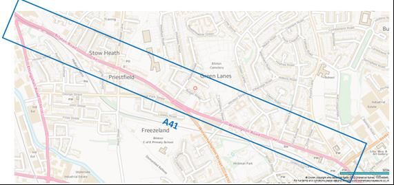
OSMM HIGHWAYS NETWORK - ROADS - TECHNICAL SPECIFICATION                                      OFFICIAL
March 2021

Trademarks

Ordnance Survey, OS, the OS Logos, OS MasterMap, AddressBase, GeoPlace, TOID, ITN and OSGB36 are
registered trademarks, and OS MasterMap Highways - Roads is a trademark of Ordnance Survey, Britain’s
mapping agency.

BaseMap is a registered trademark of Basemap Ltd.

OGC is a registered trademark of Open Geospatial Consortium, Inc.

Contact details

https://www.ordnancesurvey.co.uk/contact-us

© Ordnance Survey Ltd 2021                                                                 Page 3 of 61
OSMM HIGHWAYS NETWORK - ROADS - TECHNICAL SPECIFICATION                                                                                                                         OFFICIAL
March 2021

Contents
1.         Introduction............................................................................................................................... 6
1.1        Identifiers....................................................................................................................................................................... 7
1.1.1      TOIDs ............................................................................................................................................................................ 7
1.1.2      USRNs............................................................................................................................................................................ 8
1.1.3      Unique IDs .................................................................................................................................................................... 8
1.2        Available Formats ........................................................................................................................................................ 8
1.3        Adherence to Standards ............................................................................................................................................ 9
1.3.1      Extending INSPIRE Specification .............................................................................................................................. 9
1.4        Notation ........................................................................................................................................................................ 9
1.4.1      UML Diagram and Table Conventions ................................................................................................................... 9
1.4.2      Lexical Conventions ................................................................................................................................................. 10
1.4.3      Stereotypes ................................................................................................................................................................. 10
1.4.4      Constraints ................................................................................................................................................................. 11
1.4.5      Relationships and Associations .............................................................................................................................. 12
2.         Specification Changes ............................................................................................................. 13
2.1        Features ....................................................................................................................................................................... 13
2.2        Code Lists, Data Types and Enumerations ......................................................................................................... 13
3.     OS MasterMap Highways Network - Roads ......................................................................... 13
3.1 Common Attribution ............................................................................................................................................... 14
3.2 RoadLink ...................................................................................................................................................................... 14
3.2.1 Attributes .................................................................................................................................................................... 16
3.3 RoadNode ................................................................................................................................................................... 19
3.4 Road.............................................................................................................................................................................. 23
3.5 Street ............................................................................................................................................................................ 26
3.6 RoadJunction .............................................................................................................................................................. 31
3.7 FerryLink ..................................................................................................................................................................... 34
3.8 FerryNode................................................................................................................................................................... 36
3.9 FerryTerminal............................................................................................................................................................. 37
3.10 Data Types .................................................................................................................................................................. 39
3.10.1 Identifier ...................................................................................................................................................................... 39
3.10.2 OperationalStateType .............................................................................................................................................. 39
3.10.3 DesignatedNameType .............................................................................................................................................. 40
3.10.4 ResponsibleAuthority ............................................................................................................................................... 40
3.10.5 CycleFacilityType ....................................................................................................................................................... 41
3.10.6 ElevationGainType .................................................................................................................................................... 41
3.10.7 NumberOfLanesType ............................................................................................................................................... 41
3.10.8 RoadWidthType ........................................................................................................................................................ 42
3.11 Code Lists ................................................................................................................................................................... 43
3.11.1 ChangeValue ............................................................................................................................................................... 43
3.11.2 RoadClassificationValue ........................................................................................................................................... 43

© Ordnance Survey Ltd 2021                                                                                                                                                   Page 4 of 61
OSMM HIGHWAYS NETWORK - ROADS - TECHNICAL SPECIFICATION                                                                                                                          OFFICIAL
March 2021

3.11.3 RoadFunctionValue ................................................................................................................................................... 44
3.11.4 MatchStatusValue ...................................................................................................................................................... 45
3.11.5 OperationalStateValue ............................................................................................................................................. 45
3.11.6 ProvenanceSourceValue .......................................................................................................................................... 46
3.11.7 RoadStructureValue .................................................................................................................................................. 47
3.11.8 LinkDirectionValue ................................................................................................................................................... 47
3.11.9 FormOfWayValue ..................................................................................................................................................... 47
3.11.10 CycleFacilityValue ................................................................................................................................................... 48
3.11.11 RoadWidthConfidenceLevelValue ...................................................................................................................... 49
3.11.12 FormOfRoadNodeValue ....................................................................................................................................... 50
3.11.13 RoadNodeClassificationValue .............................................................................................................................. 50
3.11.14 AccessPointValue .................................................................................................................................................... 51
3.11.15 StreetTypeValue...................................................................................................................................................... 51
3.11.16 JunctionTypeValue .................................................................................................................................................. 51
3.11.17 ConnectionTypeValue ........................................................................................................................................... 52
3.11.18 FormOfWaterwayNodeValue ............................................................................................................................. 52
3.12 Enumeration ............................................................................................................................................................... 53
3.12.1 MinMaxLaneValue...................................................................................................................................................... 53
4.         How the product fits together? ............................................................................................. 53
5.         Change Only Update (COU) ................................................................................................. 55
5.1        Full Supply ................................................................................................................................................................... 55
5.2        Change Only Update supply ................................................................................................................................... 55
6.         Supply format .......................................................................................................................... 56
6.1        GML .............................................................................................................................................................................. 56
6.2        Schema overview and location ............................................................................................................................... 56
Annex A: GML Examples................................................................................................................. 58
Full Supply ............................................................................................................................................................................... 58
Change Only Update ............................................................................................................................................................ 58

© Ordnance Survey Ltd 2021                                                                                                                                                    Page 5 of 61
OSMM HIGHWAYS NETWORK - ROADS - TECHNICAL SPECIFICATION                                                                    OFFICIAL
March 2021

1.           Introduction
The OS MasterMap Highways Network is the authoritative highway network for Great Britain. It brings
together Ordnance Survey’s large scale road content, the National Street Gazetteer (NSG), the Trunk
Road Street Gazetteer (TRSG) and the Scottish Street Gazetteer (SSG).

OS MasterMap Highways Network is made up of four product schemas; Linear Highway Network,
Highways Dedication, Routing and Asset Management Information and Highways Water Transport
Network (Figure 1). These four schema create three products which are a part of the OS MasterMap
Highways Network family:

•    OS MasterMap Highways Network - Roads
•    OS MasterMap Highways Network - Routing and Asset Management Information
•    OS MasterMap Highways Network - Paths

This technical specification will cover the OS MasterMap Highways Network - Roads (from here referred
to as Road Network) product specification, for further details on Routing and Asset Management
Information or Paths product specification please see their Technical Specifications.

Figure 1: The conceptual INSPIRE Transport Network Model. OS MasterMap Highways will include the Linear Network, Routing and Asset
Management Information and the Water Transport Network within the Generic Network Model.

© Ordnance Survey Ltd 2021                                                                                               Page 6 of 61
OSMM HIGHWAYS NETWORK - ROADS - TECHNICAL SPECIFICATION                                                 OFFICIAL
March 2021

1.1        Identifiers
All features that comprise the OS MasterMap Highways Network – will be assigned a persistent identifier,
in most instances this is an Ordnance Survey TOID. For features which have originated from the National
Street Gazetteer or Scottish Street Gazetteer, the persistent identifier will be either a Unique Street
Reference Number (USRN) for Street features or a unique ID for Maintenance, Reinstatement, and Special
Designation.

Identifiers shall be encoded in three properties in the data:

1. gml:id – this is feature identifier comprised of the shorthand prefix namespace and local identifier which
   is used to uniquely identify and reference the feature within the dataset. Example:
   osgb4000000009461245.

2. gml:identifier – this is a global feature identifier and can be used to identify and reference the feature
   within other datasets. Example: http://data.os.uk/id/4000000009461245.

3. inspireID – this is a complex property made up of a localId, namespace and versionId which uniquely
   identifies the feature and version within an INSPIRE dataset. The versionId will not be populated in the
   OS MasterMap Highways Network products.

  http://data.os.uk/id/4000000009461245
  2010-04-01T00:00:00.000

   4000000009461245
   http://data.os.uk/
   16

Where features have come from the same source as the OS MasterMap ITN Layer the identifier will be
persistent and correspond to the same feature in ITN.

The gml:id is used throughout the OS MasterMap Highways Network products as the identifier used to
reference to other features.

1.1.1      TOIDs
TOIDs are strings of up to twenty characters which are comprised as two parts:

•   Namespace: this is either a HTTP URI (http://data.os.uk/) or shorthand prefix (‘osgb’); and
•   Local identifier: 16-digit numeric string (0-9).

Identifiers that are TOIDs manifest themselves as the following in the product:

•   gml:id – ‘osgb4000000009461245’
•   localId – ‘4000000009461245’
•   identifier - ‘http://data.os.uk/4000000009461245’

© Ordnance Survey Ltd 2021                                                                            Page 7 of 61
OSMM HIGHWAYS NETWORK - ROADS - TECHNICAL SPECIFICATION                                            OFFICIAL
March 2021

1.1.2      USRNs
USRNs are strings of up to twelve characters which are comprised of two parts:

•   Namespace: this is either a HTTP URI (http://data.os.uk/) or shorthand prefix (‘usrn’); and
•   Local identifier: up to an 8-digit numeric string (0-9).

Identifiers that are USRNs manifest themselves as the following in the product:

•   gml:id – ‘usrn82101225’
•   localId – ‘82101225’
•   identifier - ‘http://data.os.uk/82101225’

Although the gml:id is the identifier used for referencing to features in OS MasterMap Highways Network
products the localId is the identifier used by the National Street Gazetteer, National Land and Property
Gazetteer and the OS AddressBase family of products.

1.1.3      Unique IDs
Unique IDs for Maintenance, Reinstatement, Special Designation are strings of up to seventeen characters
which are comprised of two parts:

•   Namespace: this is either a HTTP URI (http://data.os.uk/) or shorthand prefix (‘id_’); and
•   Local identifier: 14 alpha numeric string.

The ID for HighwayDedication is a string of up to 25 charactes comprised of the characters “esu” followed
by three parts separated by “_”:

•   LHA authority code;
•   ESU it references; and
•   dedication code in the NSG.

e.g. esu4720_4280330430163_8, esu4720_4280340431456_11

Identifiers that are Unique IDs manifest themselves as the following in the product (examples given for both
unique ID formats):

•   gml:id – ‘id_3700MA01862142’ or ‘esu4720_4280330430163_8’
•   localId – ‘3700MA01862142’ or ‘esu4720_4280330430163_8’
•   identifier - ‘http://data.os.uk/3700MA01862142’ or ‘https://data.os.uk/id/ esu4720_4280330430163_8’

1.2        Available Formats
OS MasterMap Highways Network is supplied in GML 3.2.1.

© Ordnance Survey Ltd 2021                                                                        Page 8 of 61
OSMM HIGHWAYS NETWORK - ROADS - TECHNICAL SPECIFICATION                                             OFFICIAL
March 2021

1.3       Adherence to Standards
OS MasterMap Highways Network extends the INSPIRE Transport Networks (Road and Water) Technical
Specification (version 3.2).

OS MasterMap Generic Network model extends the INSPIRE Base Models - Generic Network Model
(version 3.0rc3).

1.3.1     Extending INSPIRE Specification
OS MasterMap Highways Network extends the INSPIRE specification to include the additional properties
required by BS 7666-1:2006 defined within the National Street Gazetteer (NSG) Data Transfer Format
(DTF) and Scottish DTF (SDTF) to ensure that conformance to both INSPIRE and BS7666-1:2006 can be
achieved.

1.4       Notation

1.4.1     UML Diagram and Table Conventions
The data structure is described by means of UML class diagrams and accompanying data dictionary tables.
The specification conforms to the rules for application schema specified in ISO 19103 Conceptual schema
language and ISO 19109 Rules for application schema, as adopted by INSPIRE.

Colour conventions have been used in the diagrams and tables to allow users to easily distinguish the
INSPIRE feature classes (coloured grey) from the Ordnance Survey feature classes which extends the
INSPIRE specifications (coloured orange). All code lists classes are coloured blue, enumeration classes are
green and data types/union classes are purple (Figure 2).

The data dictionary tables use orange for a feature type; blue for a code list; green for enumerations and
purple for data types.

© Ordnance Survey Ltd 2021                                                                         Page 9 of 61
OSMM HIGHWAYS NETWORK - ROADS - TECHNICAL SPECIFICATION                                                           OFFICIAL
March 2021

                   Figure 2: Colour conventions used in the UML diagrams within this Technical Specification

1.4.2     Lexical Conventions
•   Class names are conceptually meaningful names (singular noun) in UpperCamelCase.

•   Class names end in “Value” where the class is assigned the stereotype  or
    .

•   Class names shall end in “Type” where the class is assigned the stereotype .

•   Property names (attributes and associations) are in lowerCamelCase.

1.4.3     Stereotypes
The following stereotypes are used on UML elements:

                             UML
Stereotype                                   Description
                             Element
                                             Parent package containing sub-packages and elements that
        Package
                                             comprise part of the modular specification.

              Class           A spatial object type. [ISO 19136].

© Ordnance Survey Ltd 2021                                                                                     Page 10 of 61
OSMM HIGHWAYS NETWORK - ROADS - TECHNICAL SPECIFICATION OFFICIAL
March 2021
UML
Stereotype Description
Element
Class A structured data type with identity.
Class A structured data type without identity. [ISO/TS 19103].
A structured data type without identity where exactly one of the
Class
properties of the type is present in any instance.
Class A fixed controlled set of values for a free text data type.
A controlled set of values for a free text data type that may be
Class
extended.
A property that is required but is either not currently captured
Property
(unknown) or is partially populated (unpopulated).
Property Property considered part of the life cycle information.
1.4.4 Constraints
Constraints are defined on the Class using human readable language only. Constraints are displayed on class
diagrams (Figure 3). These constraints are used to define co-constraints or restrict INSPIRE properties
only.
Figure 3: Diagram to show how constraints will be shown in the UML diagrams in this Technical Specification
© Ordnance Survey Ltd 2021 Page 11 of 61OSMM HIGHWAYS NETWORK - ROADS - TECHNICAL SPECIFICATION OFFICIAL
March 2021
1.4.5 Relationships and Associations
There are 3 key types of relationship defined between classes (Figure 4):
• Generalisation/Specialisation: this is used to denote either:
• An extension relationship: where the target class represents the same real-world entity and is
extending it to include additional properties not defined on the parent class. NOTE this class shall
the same name as the class it is extending.
• A sub typing relationship. The target class defined a specialised sub-type of parent feature. For
example, TransportNode is a specialised sub-type of a generic Node class.
• Directed Association: used to denote relationships between features. These relationships are encoded
as references to the related feature via the identifier assigned in the gml:id. The directed end shall be
assigned a name which describes the relationship between the two features and a multiplicity.
• Aggregation: these denote part-of relationships. Aggregations are used to describe loose part-of
relationships. If the parent feature ceases to exist, then the part feature can continue to exist. For
example, a Road Name may cease to exist, but the Road will still exist.
Figure 4: Relationships between Feature Types which will be used on the UML diagrams throughout this Technical Specification
© Ordnance Survey Ltd 2021 Page 12 of 61OSMM HIGHWAYS NETWORK - ROADS - TECHNICAL SPECIFICATION OFFICIAL
March 2021
2. Specification Changes
There have been small enhancements to the OS MasterMap Highways Network. This section will outline
the main changes to the Road Network product. For changes to the Routing and Asset Management
Information product, please see the Routing and Asset Management Information Technical Specification.
2.1 Features
• RoadJunction feature has been populated.
• RoadLink and RoadNode ‘z’ values have been enhanced to reduce discrepancies when the road passes
over a structure, for example a bridge.
2.2 Code Lists, Data Types and Enumerations
• The “OperationalState” attribute on the Street features has introduced a new value, “Addressing Only”,
into the “OperationalStateValue” codelist.
• Corrected wrong multiplicity value for minimum width attribute within the “RoadWidthType” Data
Type. This had the incorrect value of ‘1’ this has been corrected to ‘0..1’.
3. OS MasterMap Highways Network - Roads
The Road Network is a topologically structured link and node network made up of the following feature
types:
1. RoadLink – A line segment representing the general alignment of the carriageway of the road.
2. RoadNode – A point connecting to at least one RoadLink, providing network connectivity.
3. Road – A Road defines the complete collection of references to RoadLink features defining the network
topology which share the same road name and/or road classification number. For example, the A38 or
Romsey Road.
4. Street – A Street feature is the definition of the street as defined in the National or Scottish Street
Gazetteer, made up of aggregated geometry with a unique identifier (USRN).
5. RoadJunction – A collection of RoadNodes that make up a named or numbered road junction.
6. FerryLink - A feature which represents a ferry route between two FerryNode’s.
7. Ferrynode - A feature representing the point at which a vehicle ferry route or section of ferry route
starts or ends.
8. FerryTerminal A feature representing the point at which vehicle transfers from the ferry network to the
road network or vice versa.
© Ordnance Survey Ltd 2021 Page 13 of 61OSMM HIGHWAYS NETWORK - ROADS - TECHNICAL SPECIFICATION OFFICIAL
March 2021
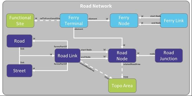
Figure 5 illustrates the relationship between the feature types.
Figure 5: Illustration to show how the Road Network feature types relate to one another.
OS MasterMap Highways Network has been built with the INSPIRE Transport Networks Data Specification
as a basis. This has been extended to include the additional properties of required by BS 7666-1:2006
defined within the NSG to ensure that conformance to both INSPIRE and BS7666-1:2006 can be achieved.
3.1 Common Attribution
Each feature within the OS MasterMap Highways Network will have the following common attribution:
• gml:id, gml:identifier and inspireId
• beginLifespanVersion
• inNetwork – this shall always be set to “OSHighwayNetwork”
• reasonForChange
• validFrom (Note: this is assigned a nilReason value “unknown” for most features)
In addition, many of the attributes which have been inherited from the INSPIRE Transport Network model
have a stereotype of ‘voidable’, for example “beginLifespanVersion”. Where these attributes have not been
populated then there is a requirement to give a reason for this. This will be specified in the GML through
an attribute called “nilReason”.
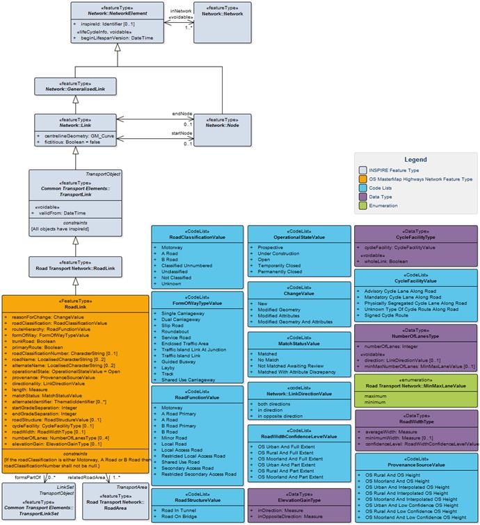
3.2 RoadLink
Overview
A RoadLink is a linear spatial object that defines the geometry and connectivity of a road network between
two points in the network. Road links can represent single carriageways, dual carriageways, slip roads,
roundabouts and indicative trajectories across traffic squares. RoadLinks will be split for connectivity
purposes (for example at junctions) and RoadNodes will connect the RoadLinks together. Each RoadLink
will provide a reference to the RoadNodes at the start and end of the RoadLink.
RoadLinks will split where two links cross over or under one another when there is no connectivity, for
example at bridges and flyovers. Therefore, the attributes “startGradeSeparation” and
“endGradeSeparation” have been populated on the RoadLink. The Grade Separation attribute will indicate
© Ordnance Survey Ltd 2021 Page 14 of 61OSMM HIGHWAYS NETWORK - ROADS - TECHNICAL SPECIFICATION OFFICIAL
March 2021
where there is or is not a physical connection between the roads in the real world. Grade Separation will
determine if a RoadLink is above another; if the two RoadLinks, when referencing the same RoadNode,
have different value then it is not possible to move between them at that point.
The context diagram (Figure 6) shows how the RoadLink has been inherited from INSPIRE and the
attribution held on the RoadLink.
Figure 6: Context Diagram: RoadLink
© Ordnance Survey Ltd 2021 Page 15 of 61OSMM HIGHWAYS NETWORK - ROADS - TECHNICAL SPECIFICATION OFFICIAL March 2021 3.2.1 Attributes «FeatureType» RoadLink Definition: A feature that represents a part or all of a highway. Constraints: If the roadClassification is either Motorway, A Road or B Road then roadClassificationNumber shall not be null. Attribute: id Definition: Unique identifier, for RoadLink this is a TOID Type: CharacterString Size: 20 Multiplicity: [1] Attribute: identifier Definition: Uniform Resource Identifier Type: CharacterString Size: 37 Multiplicity: [1] Attribute: inspireId INSPIRE Definition: External object identifier of the spatial object. Type: Identifier Multiplicity: [0..1] Attribute: beginLifespanVersion «voidable» «lifeCycleInfo» INSPIRE Definition: Date and time at which this version of the spatial object was inserted or changed in the spatial data set. Note: The time part is always set to zero. Type:DateTime Multiplicity: [1] Attribute: centrelineGeometry INSPIRE Definition: The three dimensional geometry that represents the alignment of the section of road. Type:GM_Curve Multiplicity: [1] Attribute: fictitious INSPIRE Definition: Indicator that the centreline geometry of the link is a straight line with no intermediate control points – unless the straight line represents the geography in the resolution of the data set appropriately. Type:Boolean Size: 5 Multiplicity: [1] Attribute: validFrom «voidable» INSPIRE Definition: The time when the transport link started to exist in the real world. Note: The time part is always set to zero. Type:DateTime Multiplicity: [1] Attribute: reasonForChange Definition: The reason for a change made to a feature. © Ordnance Survey Ltd 2021 Page 16 of 61
OSMM HIGHWAYS NETWORK - ROADS - TECHNICAL SPECIFICATION                                                   OFFICIAL
March 2021

Type: ChangeValue                        Size: 32                                  Multiplicity: [1]
Attribute: roadClassification
Definition: The official designated importance of a road that provides an indication of its expected
usage and importance.
Type: RoadClassificationValue            Size: 21                                  Multiplicity: [1]
Attribute: routeHierarchy
Definition: A classification of the road designed to give the most appropriate route.
Type: RoadFunctionValue                  Size: 32                                  Multiplicity: [1]
Attribute: formOfWay
Definition: A description of the road based on its nature or use.
Type: FormOfWayTypeValue                 Size: 42                                  Multiplicity: [1]
Attribute: trunkRoad
Definition: States if the RoadLink forms part of the Trunk Road network
Type: Boolean                            Size: 5                                   Multiplicity: [1]
Attribute: primaryRoute
Definition: States if the RoadLink forms part of the Primary Route network
Type: Boolean                            Size: 5                                   Multiplicity: [1]
Attribute: roadClassificationNumber
Definition: The official road number assigned by the appropriate authority. Note that this includes at
least one letter. For example ‘A329(M)’
Type: CharacterString                    Size: 10                                  Multiplicity: [0..1]
Attribute: roadName
Definition: The name of the road the feature is part of. When a RoadLink is referenced by a Street
with a streetStateType of Designated Street Name this is the name used else the name is from Road.
Note: Where a feature has more than one name, the language of each name is provided as a 3-digit
ISO 639-2 code (‘eng’, ‘cym’, ‘gla’).
Type: LocalisedCharacterString           Size: 255                                 Multiplicity: [0..2]
Attribute: alternateName
Definition: Another name for the road the feature is part of, this is populated with the name captured
by Ordnance Survey when it differs from that in Street.
Note: Where a feature has more than one name, the language of each name is provided as a 3-digit
ISO 639-2 code (‘eng’, ‘cym’, ‘gla’).
Type: LocalisedCharacterString           Size: 255                                 Multiplicity: [0..2]
Attribute: operationalState

© Ordnance Survey Ltd 2021                                                                             Page 17 of 61
OSMM HIGHWAYS NETWORK - ROADS - TECHNICAL SPECIFICATION                                                     OFFICIAL
March 2021

Definition: Indicator identifying the construction status of the road
Type: OperationalStateValue                  Size: 19                                Multiplicity: [1]
Attribute: provenance
Definition: The origin and derivation of the three dimensional geometry of the RoadLink.
Type: ProvenanceSourceValue                  Size: 23                                Multiplicity: [1]
Attribute: directionality
Definition: Indication of the direction of traffic flow.
Type: LinkDirectionValue                     Size: 21                                Multiplicity: [1]
Attribute: length
Definition: The calculated two-dimensional length of the RoadLink in metres.
Note: A Unit of Measure (uom) is provided as part of the attribute which will always be ‘m’.
Type: Measure                                Size: 7,2                               Multiplicity: [1]
Attribute: matchStatus
Definition: Indicates whether the feature has been matched to a feature in the NSG.
Type: MatchStatusValue                       Size: 39                                Multiplicity: [1]
Attribute: alternateIdentifier
Definition: Identifier(s) of the Elementary Street Unit from NSG or TRSG.
Type: ThematicIdentifier                     Size: 20                                Multiplicity: [0..*]
Attribute: startGradeSeparation
Definition: The relative level of the link at the startNode.
Type: Integer                                                                        Multiplicity: [1]
Attribute: endGradeSeparation
Definition: The relative level of the link at the endNode.
Type: Integer                                                                        Multiplicity: [1]
Attribute: roadStructure
Definition: Identifies if this section of road passes through or over a physical structure.
Type: RoadStructureValue                     Size: 14                                Multiplicity: [0..1]
Attribute: cycleFacility
Definition: Identifies if the RoadLink has facilities for a cyclist.
Type: CycleFacilityType                                                              Multiplicity: [0..1]
Attribute: roadWidth
Definition: An indication of the width of the road carriageway as recorded in the OS MasterMap
Topography layer, this must not be used to identify whether individual vehicles can use a route.

© Ordnance Survey Ltd 2021                                                                               Page 18 of 61
OSMM HIGHWAYS NETWORK - ROADS - TECHNICAL SPECIFICATION                                                    OFFICIAL
March 2021

Type: RoadWidthType                                                                 Multiplicity: [0..1]
Attribute: numberOfLanes
Definition: The number of lanes along a RoadLink.
Note: Values not populated in this release.
Type: NumberOfLanesType                                                             Multiplicity: [0..4]
Attribute: elevationGain
Definition: The elevation gain is calculated from three-dimensional geometry to define the total ascent
experienced when passing along a RoadLink feature.
The value is expressed both with and against the coordinate order.
Type: ElevationGainType                                                             Multiplicity: [0..1]
    Association: formsPartOf
Definition: Identifier of the Road or Street to which the RoadLink forms part of.
Multiplicity: 0..*                        Size: 20
    Association: startNode                                                                          INSPIRE
Definition: The node coincident with the first vertex of the geometry attribute.
Multiplicity: 0..1                        Size: 20
    Association: endNode                                                                            INSPIRE
Definition: The node coincident with the last vertex of the geometry attribute.
Multiplicity: 0..1                        Size: 20
    Association: relatedRoadArea
Definition: Reference to the topographic representation(s) of the same part of the road.
Multiplicity: 1..*                        Size: 20

3.3          RoadNode
Overview

A point spatial object that is used to break up the road network for connectivity. The road network splits
for the following circumstances:

•     The location where an attribute recorded on the road link changes for example its name or form;

•     The intersection or crossing of Roads (including bridges, flyovers and tunnels where there is no
      connectivity);

•     The start/end of a Road;

•     Where a One Way Routing feature starts or ends; and

© Ordnance Survey Ltd 2021                                                                           Page 19 of 61
OSMM HIGHWAYS NETWORK - ROADS - TECHNICAL SPECIFICATION OFFICIAL
March 2021
• Where a tunnel starts or ends.
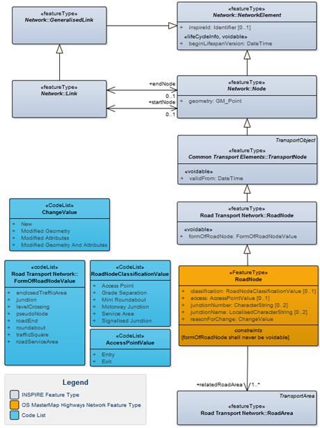
The context diagram (Figure 7) shows how the RoadNode has been inherited from INSPIRE and the
attribution held on the RoadNode.
Figure 7: Context Diagram: RoadNode
Attributes
«FeatureType» RoadNode
Definition: A point representing either the start/end of a road, the connectivity between two or more
roads or where one of the recorded attributes changes along a road.
Constraints:
formOfRoadNode shall never be voidable
© Ordnance Survey Ltd 2021 Page 20 of 61OSMM HIGHWAYS NETWORK - ROADS - TECHNICAL SPECIFICATION OFFICIAL March 2021 Attribute: id Definition: Unique identifier, for RoadNode this is a TOID Type: CharacterString Size: 20 Multiplicity: [1] Attribute: identifier Definition: Uniform Resource Identifier Type: CharacterString Size: 37 Multiplicity: [1] Attribute: inspireId INSPIRE Definition: External object identifier of the spatial object. Type: Identifier Multiplicity: [0..1] Attribute: beginLifespanVersion «lifeCycleInfo» «voidable» INSPIRE Definition: Date and time at which this version of the spatial object was inserted or changed in the spatial data set. Note: The time part is always set to zero. Type:DateTime Multiplicity: [1] Attribute: validFrom «voidable» INSPIRE Definition: The time when the transport node started to exist in the real world. Note: The time part is always set to zero. Type:DateTime Multiplicity: [1] Attribute: geometry INSPIRE Definition: The three dimensional location of the node. For nodes representing grade separated intersections the elevation is of the lower road Type:GM_Point Multiplicity: [1] Attribute: formOfRoadNode «voidable» INSPIRE Definition: Description of the function of a road node in the road transport network. Type:FormOfRoadNodeValue Size: 21 Multiplicity: [1] Attribute: classification Definition: Further specialisation of the form of road node. Type: RoadNodeClassificationValue Size: 19 Multiplicity: [0..1] Attribute: access Definition: Point where vehicles can either exit or enter a controlled-access highway. Note: Values not populated in the initial release. Type: AccessPointValue Size: 5 Multiplicity: [0..1] Attribute: junctionName © Ordnance Survey Ltd 2021 Page 21 of 61
OSMM HIGHWAYS NETWORK - ROADS - TECHNICAL SPECIFICATION                                                 OFFICIAL
March 2021

Definition: The name of any junction that the node represents part of.
Note: Where a feature has more than one name, the language of each name is provided as a 3-digit
ISO 639-2 code (‘eng’, ‘cym’, ‘gla’).
Type: LocalisedCharacterString          Size: 120                                Multiplicity: [0..2]
Attribute: junctionNumber
Definition: The number of any motorway junction that the node represents part of, for example M3
J12.
Type: CharacterString                   Size: 30                                 Multiplicity: [0..2]
Attribute: reasonForChange
Definition: The reason for a change made to a feature.
Type: ChangeValue                       Size: 32                                 Multiplicity: [1]
Association: relatedRoadArea
Definition: Reference to the topographic representation(s) of the same part of the road.
Multiplicity: 1..*                     Size: 20

© Ordnance Survey Ltd 2021                                                                           Page 22 of 61
OSMM HIGHWAYS NETWORK - ROADS - TECHNICAL SPECIFICATION OFFICIAL
March 2021
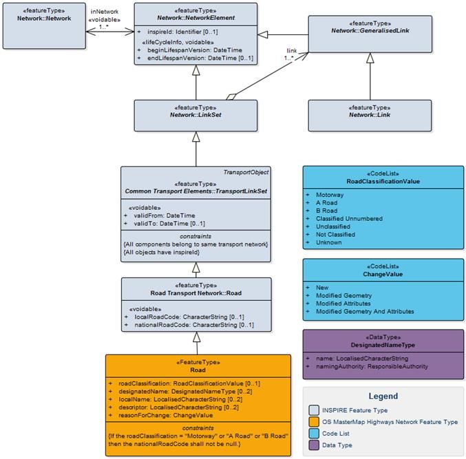
3.4 Road
Overview
Figure 8: A Road feature for the A41
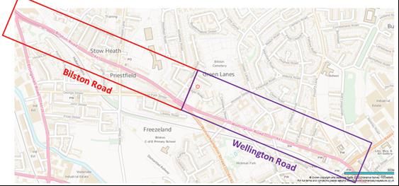
Figure 9: Two Road features covering the two named thoroughfares which make up the A41
A Road feature is a link set which represents a collection of RoadLink features used primarily by motorised
vehicles that share the same name (e.g. Bilston Road) or classification number (e.g. A41). A Road will
reference the complete collection of RoadLink features irrespective of which authority boundary it falls
within. The feature will include Motorways, A Roads, B Roads and Named Thoroughfares (roads), as
illustrated in Figure 8 and Figure 9.
© Ordnance Survey Ltd 2021 Page 23 of 61OSMM HIGHWAYS NETWORK - ROADS - TECHNICAL SPECIFICATION OFFICIAL
March 2021
The link set may not be contiguous across junctions or where a classified road consists of separate
sections, which may be separated by some considerable distance. In addition, the same RoadLink feature
may be referenced by multiple Road features.
The context diagram (Figure 10) shows how the Road has been inherited from INSPIRE and the attribution
held on the Road.
Figure 10: Context Diagram: Road
Attributes
«FeatureType» Road
Definition: A compound feature that represents a road with a name or number. This may be a
classified road, such as the A38, or a named road such as Romsey Road. This references a collection of
RoadLinks.
© Ordnance Survey Ltd 2021 Page 24 of 61OSMM HIGHWAYS NETWORK - ROADS - TECHNICAL SPECIFICATION OFFICIAL March 2021 Constraints: If the roadClassification = "Motorway" or "A Road" or "B Road" then the nationalRoadCode shall not be null. Attribute: id Definition: Unique identifier, for Road this is a TOID Type: CharacterString Size: 20 Multiplicity: [1] Attribute: identifier Definition: Uniform Resource Identifier Type: CharacterString Size: 37 Multiplicity: [1] Attribute: inspireId INSPIRE Definition: External object identifier of the spatial object. Type: Identifier Multiplicity: [0..1] Attribute: beginLifespanVersion «lideCycleInfo» «voidable» INSPIRE Definition: Date and time at which this version of the spatial object was inserted or changed in the spatial data set. Note: The time part is always set to zero. Type:DateTime Multiplicity: [1] Attribute: validFrom «voidable» INSPIRE Definition: The time when the transport link set started to exist in the real world. Note: The time part is always set to zero. Type:DateTime Multiplicity: [1] Attribute: localRoadCode «voidable» INSPIRE Definition: Identification code assigned to the road by the local road authority. Type:CharacterString Size: 10 Multiplicity: [0..1] Attribute: nationalRoadCode «voidable» INSPIRE Definition: The national number of the road. Type:CharacterString Size: 10 Multiplicity: [0..1] Attribute: roadClassification Definition: The national classification of the road. Type: RoadClassificationValue Size: 21 Multiplicity: [0..1] Attribute: designatedName Definition: Official name assigned to the highway by a designated Street Naming Authority. Note: On the Road feature this will always be the OS name. © Ordnance Survey Ltd 2021 Page 25 of 61
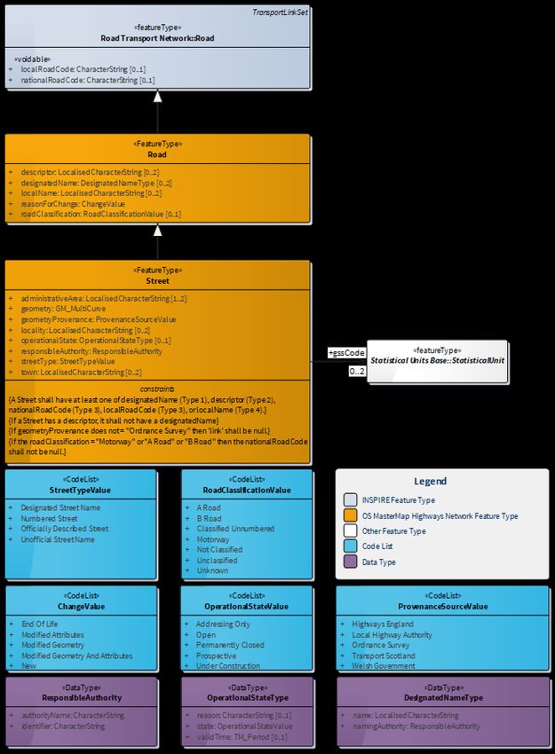
OSMM HIGHWAYS NETWORK - ROADS - TECHNICAL SPECIFICATION                                                   OFFICIAL
March 2021

Type: DesignatedNameType                                                           Multiplicity: [0..2]
Attribute: reasonForChange
Definition: The reason for a change made to a feature.
Type: ChangeValue                         Size: 32                                 Multiplicity: [1]
 Aggregation: link                                                                                 INSPIRE
Definition: The reference to the RoadLink features which builds up the Road feature.
Multiplicity: 1..*                       Size: 20

3.5        Street
Overview

A Street feature (Figure 11) is the definition of the street as defined in the National or Scottish Street
Gazetteer. A Street includes aggregated geometry. Where possible, the geometry of streets captured by a
Roads or Highway Authority is spatially matched to the geometry of OS RoadLinks.

1. if any of the Street’s Elementary Street Unit(s) (ESUs) have been matched to a RoadLink(s) then the
   aggregated geometry of the RoadLink(s) will be provided.

2. if none of the Street’s ESUs have been matched to a RoadLink then the aggregated geometry of the
   ESUs will be provided.

The provenance of this geometry can be identified through the “geometryProvenance” attribute. They will
represent either the complete Street or a section of a Street within an Administrative Unit, Town, or
Locality and provides additional information about who is responsible for its naming and or numbering. A
RoadLink can be referenced by multiple Street features.

The Street extends the Road to provide the additional attribution required to adhere to BS 7666:

1. USRN: The Unique Street Reference Number is the unique and persistent identifier of a Street assigned
   by the Roads or Highway Authority.

2. Street Type: The type of Gazetteer record for which the USRN relates. It is mandatory for all USRNs
   to be assigned a Street Type.

3. Operational State: indicates whether the Street is proposed, under construction, open, or closed
   (permanently or temporarily).

4. Responsible Authority: reference to the authority who performs an administrative function – notably
   naming and numbering.

A Street will split when it crosses the boundary of an Administrative Area where the local maintenance
responsibility changes. A Street could also split at a town or locality boundary to allow properties to be
located uniquely upon a street via a unique identifier (i.e. USRN).

Note, in the definitions below users should read the term Highways as Roads when applied to streets in
Scotland.

© Ordnance Survey Ltd 2021                                                                             Page 26 of 61
OSMM HIGHWAYS NETWORK - ROADS - TECHNICAL SPECIFICATION                    OFFICIAL
March 2021

                                   Figure 11: Context Diagram: Street

© Ordnance Survey Ltd 2021                                              Page 27 of 61
OSMM HIGHWAYS NETWORK - ROADS - TECHNICAL SPECIFICATION OFFICIAL
March 2021
Attributes
«FeatureType» Street
Definition: Any road, footway, path, cycletrack, track or passageway that forms a highway.
A highway represents individual subsections of Road which are managed (naming/numbering) by a
specified responsible authority.
Constraints:
• A Street shall have at least one of designatedName (Type 1), descriptor (Type 2),
nationalRoadCode (Type 3), localRoadCode (Type 3), or localName (Type 4).
• If a Street has a descriptor, it shall not have a designatedName.
• If geometryProvenance does not = "Ordnance Survey" then 'link' shall be null.
• If the roadClassification = "Motorway" or "A Road" or "B Road" then the nationalRoadCode
shall not be null.
Attribute: id
Definition: Unique identifier, for Street the characters “USRN” appended with the USRN e.g.
USRN12345678
Type: CharacterString Size: 12 Multiplicity: [1]
Attribute: identifier
Definition: Uniform Resource Identifier
Type: CharacterString Size: 29 Multiplicity: [1]
Attribute: inspireId INSPIRE
Definition: External object identifier of the spatial object.
Note: This is the USRN from the NSG or TRSG or SSG.
Type: Identifier Multiplicity: [0..1]
Attribute: beginLifespanVersion «lifeCycleInfo» «voidable» INSPIRE
Definition: Date and time at which this version of the spatial object was inserted or changed in the
spatial data set.
Note: The time part is always set to zero.
Type:DateTime Multiplicity: [1]
Attribute: validFrom «voidable» INSPIRE
Definition: The time when the transport link set started to exist in the real world.
Note: The time part is always set to zero.
Type:DateTime Multiplicity: [1]
Attribute: localRoadCode «voidable» INSPIRE
Definition: Identification code assigned to the road by the local road authority.
Note: This is only used for classified unnumbered roads.
© Ordnance Survey Ltd 2021 Page 28 of 61OSMM HIGHWAYS NETWORK - ROADS - TECHNICAL SPECIFICATION OFFICIAL March 2021 Type:CharacterString Size: 120 Multiplicity: [0..1] Attribute: nationalRoadCode «voidable» INSPIRE Definition: The national number of the road. Type:CharacterString Size: 10 Multiplicity: [0..1] Attribute: designatedName Definition: Official name assigned to the highway by the Street Naming Authority. Type:DesignatedNameType Multiplicity: [0..2] Attribute: localName Definition: Unofficial local name associated to the highway. Note: Where a feature has more than one name, the language of each name is provided as a 3-digit ISO 639-2 code (‘eng’, ‘cym’, ‘gla’). Type:LocalisedCharacterString Size: 120 Multiplicity: [0..2] Attribute: descriptor Definition: Street description allocated by a Street Naming Authority or Highway Authority used to identify a street that does not have a designated name. Note: Where a feature has more than one name, the language of each name is provided as a 3-digit ISO 639-2 code (‘eng’, ‘cym’, ‘gla’). Type:LocalisedCharacterString Size: 120 Multiplicity: [0..2] Attribute: reasonForChange Definition: The reason for a change made to a feature. Type:ChangeValue Size: 32 Multiplicity: [1] Attribute: roadClassification Definition: The national classification of the road. Type:RoadClassificationValue Size: 21 Multiplicity: [0..1] Attribute: streetType Definition: Classification of the type of Street from the National Street Gazetteer. Type: StreetTypeValue Size: 35 Multiplicity: [1] Attribute: operationalState Definition: Indicator identifying the physical nature of the road e.g. Under Construction. Type: OperationalStateType Multiplicity: [0..1] Attribute: locality Definition: The Populated Place representing the locality that the Street is located within. Note: Where a feature has more than one name, the language of each name is provided as a 3-digit ISO 639-2 code (‘eng’, ‘cym’, ‘gla’). © Ordnance Survey Ltd 2021 Page 29 of 61
OSMM HIGHWAYS NETWORK - ROADS - TECHNICAL SPECIFICATION                                                   OFFICIAL
March 2021

Type: LocalisedCharacterString            Size: 35                                 Multiplicity: [0..2]
Attribute: town
Definition: The settlement that the Street falls within.
Note: Where a feature has more than one name, the language of each name is provided as a 3-digit
ISO 639-2 code (‘eng’, ‘cym’, ‘gla’).
Type: LocalisedCharacterString            Size: 30                                 Multiplicity: [0..2]
Attribute: administrativeArea
Definition: The administrative area that the Street is located within
Note: Where a feature has more than one name, the language of each name is provided as a 3-digit
ISO 639-2 code (‘eng’, ‘cym’, ‘gla’).
Type: LocalisedCharacterString            Size: 30                                 Multiplicity: [1..2]
Attribute: responsibleAuthority
Definition: Reference to the authority that has current responsibility for naming and numbering.
Type: ResponsibleAuthority                                                         Multiplicity: [1]
Attribute: geometryProvenance
Definition: Identify where the geometry of the feature originated.
Type: ProvenanceSourceValue               Size: 23                                 Multiplicity: [1]
Attribute: geometry
Definition: The aggregated geometry of either the matched RoadLinks or the Elementary Street Units.
Type: GM_MultiCurve                                                                Multiplicity: [1]
Association: gssCode
Definition: A reference to the unique identifier of administrative areas managed by the Office for
National Statistics. Role is used to describe the authority - 'Upper Tier Local Authority', 'Lower Tier
Local Authority' and 'Unitary Local Authority'
Multiplicity: 0..2                                                                 Size: 9
Aggregation: link                                                                      INSPIRE
Definition: The reference to the RoadLink features which builds up the Street feature. Where the
Street has not been matched to a RoadLink this attribute will be voided.
Multiplicity: 1..*                                                                 Size: 20

© Ordnance Survey Ltd 2021                                                                             Page 30 of 61
OSMM HIGHWAYS NETWORK - ROADS - TECHNICAL SPECIFICATION OFFICIAL
March 2021
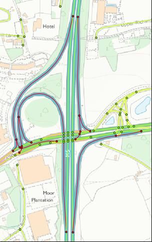
3.6 RoadJunction
Overview
A RoadJunction feature is a collection of RoadNode features that share the same road junction name or
number. The collection of RoadNodes will include all RoadNodes that constitute part of a “slip road” or
other link between two or more crossing road features (Figure 12). A RoadNode could be referenced by
multiple RoadJuntion features.
Motorway Junctions will be populated completely, other junctions are being supplied as data is improved
for future releases.
Figure 12: Collection of RoadNodes making up a Road Junction (highlighted red).
RoadLinks representing the slip road are highlighted red for clarification only.
© Ordnance Survey Ltd 2021 Page 31 of 61OSMM HIGHWAYS NETWORK - ROADS - TECHNICAL SPECIFICATION OFFICIAL
March 2021
The context diagram (Figure 13) shows how the RoadJunction feature relates back to the Network
Elements.
Figure 13: Context Diagram: RoadJunction
Attributes
«FeatureType» RoadJunction
Definition: A compound feature that represents a road junction with a name or number.
Attribute: id
Definition: Unique identifier, for RoadJunction this is a TOID
Type: CharacterString Size: 20 Multiplicity: [1]
Attribute: identifier
Definition: Uniform Resource Identifier
Type: CharacterString Size: 37 Multiplicity: [1]
Attribute: inspireId INSPIRE
Definition: External object identifier of the spatial object.
Type: Identifier Multiplicity: [0..1]
Attribute: beginLifespanVersion «voidable» «lifeCycleInfo» INSPIRE
© Ordnance Survey Ltd 2021 Page 32 of 61You can also read