Prediction of Impending Drought Scenarios Based on Surface and Subsurface Parameters in a Selected Region of Tropical Queensland, Australia
←
→
Page content transcription
If your browser does not render page correctly, please read the page content below
Journal of Water Resource and Protection, 2021, 13, 605-631
                                                                                             https://www.scirp.org/journal/jwarp
                                                                                                          ISSN Online: 1945-3108
                                                                                                            ISSN Print: 1945-3094

Prediction of Impending Drought Scenarios
Based on Surface and Subsurface Parameters in
a Selected Region of Tropical Queensland,
Australia

Bithin Datta1*, Dilip Kumar Roy2, Jonathan J. Kelley1, Bradley Stevens1

Discipline of Civil Engineering, College of Science and Engineering, James Cook University, Townsville, Australia
1

Irrigation and Water Management Division, Bangladesh Agricultural Research Institute, Joydebpur, Bangladesh
2

How to cite this paper: Datta, B., Roy,       Abstract
D.K., Kelley, J.J. and Stevens, B. (2021)
Prediction of Impending Drought Scenari-      Droughts occur in all climatic regions around the world costing a large ex-
os Based on Surface and Subsurface Pa-        pense to global economies. Reasonably accurate prediction of drought events
rameters in a Selected Region of Tropical     helps water managers proper planning for utilization of limited water re-
Queensland, Australia. Journal of Water
                                              sources and distribution of available waters to different sectors and avoid cat-
Resource and Protection, 13, 605-631.
https://doi.org/10.4236/jwarp.2021.138033     astrophic consequences. Therefore, a means to create a simplistic approach
                                              for forecasting drought conditions with easily accessible parameters is highly
Received: July 1, 2021                        desirable. This study proposes and evaluates newly developed accurate pre-
Accepted: August 8, 2021                      diction models utilizing various hydrologic, meteorological, and geohydrolo-
Published: August 11, 2021
                                              gy parameters along with the use of Artificial Neural Network (ANN) models
Copyright © 2021 by author(s) and             with various forecast lead times. The present study develops a multitude of
Scientific Research Publishing Inc.           forecasting models to predict drought indices such as the Standard Precipita-
This work is licensed under the Creative      tion Index with a lead-time of up to 6 months, and the Soil Moisture Index
Commons Attribution International
                                              with a lead-time of 3 months. Furthermore, prediction models with the capa-
License (CC BY 4.0).
http://creativecommons.org/licenses/by/4.0/   bility of approximating surface and groundwater storage levels including the
               Open Access                    Ross River Dam level have been developed with relatively high accuracy with
                                              a lead-time of 3 months. The results obtained from these models were com-
                                              pared to current values, revealing that ANN based approach can be used as a
                                              simple and effective predictive model that can be utilized for prediction of
                                              different aspects of drought scenarios in a typical study area like Townsville,
                                              North Queensland, Australia which had suffered severe recent drought con-
                                              ditions for almost six recent years (2014 to early 2019).

                                              Keywords
                                              Drought Prediction, Artificial Neural Network, Prediction Model, Dam
                                              Levels, Aquifer Salinity, Water Storage, Townsville Queensland

DOI: 10.4236/jwarp.2021.138033         Aug. 11, 2021            605                     Journal of Water Resource and Protection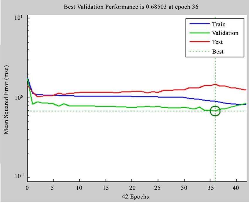
B. Datta et al.

                                 1. Introduction
                                 The main problem with mitigating the consequences of a drought is that a drought
                                 is generally identified only after the drought has started and we are well into a
                                 drought scenario. This lack of proper early prediction of droughts can prevent
                                 efficient management of drought without adequate foresight. The tropical north-
                                 ern part of the Queensland state in Australia had been reeling under a severe
                                 drought for several years. Although drought conditions in Townsville and sur-
                                 rounding areas were declared officially in 2015, the drought had been in full
                                 swing by then with visible signs of extreme water scarcity. Because of the severe
                                 constraints on water use, as the result of the existing drought condition, the
                                 economy of the region suffered substantially. Early detection and prediction of
                                 the drought could have lessened the enormous economic costs and the associat-
                                 ed hardships. Therefore, this study was undertaken to develop at least prelimi-
                                 nary models capable of predicting future drought scenarios in this region with
                                 some forecast lead time. Such predictions can enormously help manage the sup-
                                 ply and demand sides of water resources, with enormous benefits resulting from
                                 early detection and prediction of droughts. Both subsurface storage levels as well
                                 as surface storage in the Ross River dam situated in Townsville, Northern
                                 Queensland were incorporated in the prediction models for drought scenarios.
                                 In addition, aquifer salinity level prediction models were developed.
                                   The term drought has been recognized around the world as an environmental
                                 disaster costing a large expense to global economies. The occurrences of droughts
                                 are likely in most climatic regions around the world following rainfall deficien-
                                 cies over an extended period. The recent droughts in the state of California in
                                 the U.S.A. is a glaring example. Temperatures, high winds, low relative humidi-
                                 ty, timing, and characteristics of rains including distribution of rainy days dur-
                                 ing crop growing seasons as well as onset, intensity, duration, and terminations
                                 of rain play a significant role in the occurrence of drought [1]. Droughts can ef-
                                 fectively be classified into three main categories: meteorological drought, agri-
                                 cultural drought, and hydrological drought [2]. Meteorological drought is con-
                                 sidered as the ongoing shortage of precipitation, which usually affects a large ar-
                                 ea (i.e., North Queensland). Meteorological drought is the originating source of
                                 drought that triggers the other two types of droughts. Agricultural drought is re-
                                 lated to the scarcity of water needed to meet the requirement of crop production
                                 or plant growth. Hydrological drought can be defined as the occurrence of low
                                 flow in watercourses, and the below average levels of lakes and groundwater. It is
                                 related to a period with a decrease in surface and groundwater resources availa-
                                 ble for uses of an established water resource system [1]. A lack of precipitation
                                 often triggers agricultural and hydrological droughts, but other factors, includ-
                                 ing more intense but less frequent precipitation, poor water management, and
                                 erosion, can also cause or enhance these droughts.
                                   Among others, lack of rain is the main cause of drought. It has, however, been
                                 noted that both Hydro-meteorological variables and climate indices have a sig-

DOI: 10.4236/jwarp.2021.138033                        606                    Journal of Water Resource and Protection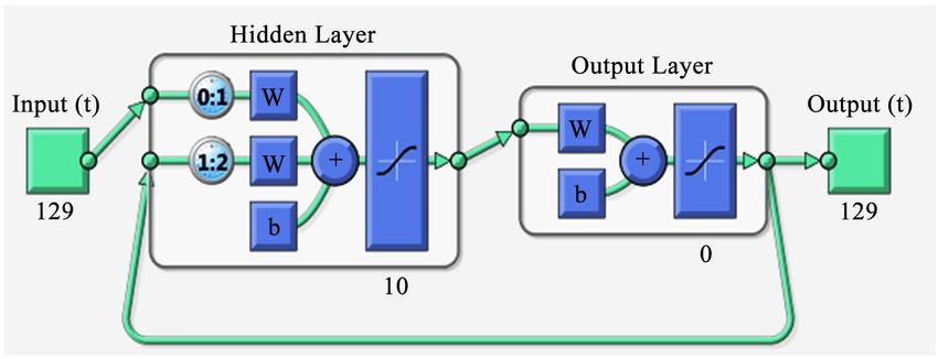
B. Datta et al.

                                 nificant effect on the cause, duration, and intensity of a drought. However, the
                                 intensity of a drought may not solely depend on the rainfall occurrence [3]. The
                                 occurrence of precipitation is perhaps the fundamental parameter regarding the
                                 initiation of drought. As stated previously, meteorological drought occurs be-
                                 cause of rainfall deficiencies that are ultimately a precursor for agricultural and
                                 hydrological drought. Therefore, the justification behind rainfall deficiencies is
                                 an important aspect of drought. The lack of rain can be linked to many causes
                                 related to climate indices and anomalies (such as the El Niño Southern Oscilla-
                                 tion (ENSO) event) and possibly even climate change [4]. Whilst these climate
                                 indices and anomalies have a large influence on the occurrence of drought, pre-
                                 sent study does not address these issues, as the intention is to develop a simple
                                 prediction model within the scope of the data availability for the study area.
                                 Poor water management can often be one of the lead causes behind drought se-
                                 verity and localized occurrence. The use of ineffective and failed water manage-
                                 ment plans can effectively increase the severity of localized drought conditions
                                 with the inappropriate use of water.
                                   The severity of droughts can be characterized by drought indexes that have
                                 been developed to detect, monitor, and assess drought events [5]. Drought indi-
                                 cators essentially are variables that identify and assess drought conditions, which
                                 are commonly based on hydrological and meteorological variables. There are
                                 numerous indices used throughout the industry that has played a major role in
                                 drought management. The most commonly used indices include Palmer Drought
                                 Severity Index (PDSI), Standard Precipitation Index (SPI), Soil Moisture Index
                                 (SMI), and Southern Oscillation Index (SOI). Drought indicators facilitate an
                                 effective way of understanding the characteristics of a particular drought event.
                                 Each of the above indicators is utilized for identification and classification of the
                                 drought event occurrence. Each of these indicators is dependent on the quanti-
                                 fying parameters used. For example, the SPI considers only precipitation, whilst
                                 PDSI considers precipitation, evapotranspiration, and runoff. Although the
                                 PDSI may be more reliable, SPI is a simplistic model that provides accurate
                                 analysis. The use of any of these indicators depends on the input data available
                                 and the region being considered (when calculating climate Indices), and these
                                 indicators provide useful stepping-stone to a forecasting model.
                                    There are a few researchers, who have developed forecasting models to assist
                                 in the prediction of drought occurrence, intensity, and duration [6] [7] [8] [9].
                                 These forecast models rely heavily on large amounts of spatial data and complex
                                 modelling procedures. Therefore, accurate and long-term data are needed to
                                 work effectively with these models. However, in many parts of the world, such as
                                 regional North Queensland, Australia has extremely limited amount of temporal
                                 and spatial data. As a result, many of the forecasting models that have been used
                                 elsewhere may not be suitable for the tropical Townsville region, in north
                                 Queensland, Australia due to the limited amount of relevant data. Therefore, it is
                                 necessary to construct modelling solutions that can derive desired output varia-
                                 bles with minimal input variables. This may be achieved through modelling

DOI: 10.4236/jwarp.2021.138033                        607                     Journal of Water Resource and Protection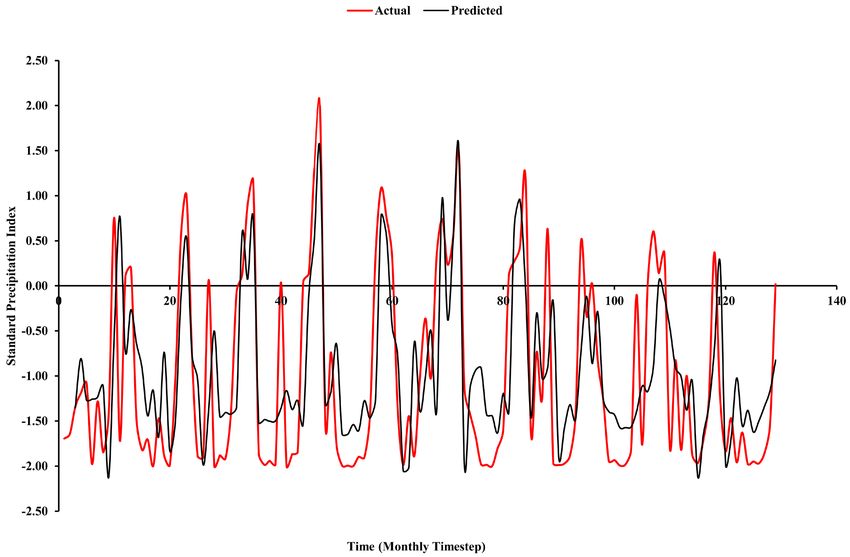
B. Datta et al.

                                 networks such as Artificial Neural Network (ANN) models through which effec-
                                 tive drought prediction, and management of its consequences can be achieved. If
                                 an effective drought prediction model can be derived, the management of water
                                 resources can reduce the implications of drought. Restriction schemes and water
                                 penalties can be applied in an effective manner and adequate distribution to ag-
                                 ricultural regions may be achieved. Hence this attempt at preliminary develop-
                                 ment of drought models for this region. The recent severe drought in the
                                 Townsville and surrounding areas of tropical Northern Queensland resulting in
                                 severe constraints on availability and use of water was the motivation to try and
                                 develop drought prediction models which can be beneficial for more efficient
                                 management of water supply based on better forecasting of drought conditions.
                                 The ANN was chosen as a training and testing-based pattern recognition tool to
                                 learn and extract information from the patterns of input parameter values and
                                 the resulting drought conditions as outputs. It was also envisaged that the ANN
                                 based predictions also can utilize the capabilities of the ANN to recognize rele-
                                 vant input data contributing to better prediction. The different modelling tools
                                 used for prediction of drought scenarios at different parts of the world are briefly
                                 discussed here.
                                    The probability of occurrence and the severity of drought can be forecasted by
                                 regression analysis [10]. The development of a regression analysis model that
                                 exhibited the grain yield of a crop was developed by Kumar and Panu [6]. The
                                 use of crop yield as an agricultural drought quantifying parameter and multiple
                                 variables affecting crop yield as explanatory variables was used for the assess-
                                 ment of agricultural drought forecasting [1]. The model generated by Kumar
                                 and Panu [6] is capable of explaining approximately 82 percent of the variation
                                 of grain yield and was able to predict the yield several months in advance. How-
                                 ever, they found that the moisture index of the soil had marginal contribution to
                                 the analysis and accounted for insignificant variation in yield [6]. Another study
                                 conducted by Liu and Juárez [8] used ENSO indices and satellite recorded Nor-
                                 malized Difference Vegetation Index (NDVI) to construct a drought prediction
                                 model using a multiple linear regression technique for a region in Brazil. Three
                                 regression models were generated using an NDVI anomaly as a dependent vari-
                                 able and various ENSO index anomalies as independent variables. It was con-
                                 cluded in this study that the use of satellite recorded NDVI rather than precipi-
                                 tation data improved the correlation with the ENSO indices. Whereas, the third
                                 model generated, using a dataset with high anomaly values of NVDI and ENSO
                                 indices, predicted drought onset in the Brazilian region four months in advance
                                 with a success rate of 68 percent [8].
                                    Time series analysis has also successfully been utilized for drought forecasting
                                 by several researchers in different parts of the world. The advantages of using
                                 this tool include its efficient search capability for estimations, identification, and
                                 analytical checking, capabilities important for model development [9]. Auto-
                                 regressive Integrated Moving Average (ARIMA) and Seasonal Autoregressive
                                 Integrated Moving Average (SARIMA) are two of the commonly used stochastic

DOI: 10.4236/jwarp.2021.138033                        608                     Journal of Water Resource and Protection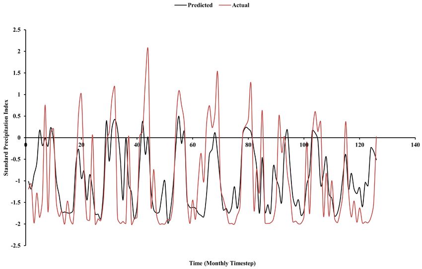
B. Datta et al.

                                 models that are generally fitted to Time Series data. Furthermore, seasonal data
                                 can be utilized by using the Seasonal ARIMA model, which is written as, ARIMA
                                  ( p, d , q ) ( P, D, Q) m , in which the second part considers the seasonal data [7].
                                 These models can be used through computer programming where auto-generation
                                 of the model is achieved by input data. This modelling system has been used in
                                 various drought applications including the modelling of a drought forecasting
                                 parameter. The use of both yearly and monthly PDI, utilized as stochastic input
                                 data for quantifying a parameter, was used in combination with ARIMA models
                                 to simulate and forecast PDI models by Rao and Padmanabhan [11]. Further-
                                 more, a study conducted by Fernandez, et al. [12] using a multiplicative seasonal
                                 ARIMA model, had the ability to forecast stream flow with a lead-time of 12
                                 months. Drought indices were derived based on this predicted average stream
                                 flow over different periods. However, the capability of this forecast is strongly
                                 dependent on the identification, estimation, and diagnostic checks to select the
                                 best model [10].
                                     ANN models, mimicking the operation of a human brain can be utilized to
                                 forecast the values of the predicted set based on a set of predictors or input vari-
                                 ables [13]. A major advantage of using an ANN model, especially for forecasting,
                                 is that intermediate relationships between inputs and outputs do not need to be
                                 fully defined. This capability of ANN makes it suitable for prediction of drought
                                 forecasting in which the relationship between the large numbers of complex in-
                                 put variables can produce suitable output solutions [10]. A good example of the
                                 application of ANN modelling approach in drought prediction is the work con-
                                 ducted by Morid, et al. [14], where they predicted quantitative values of drought
                                 indices. This involved using multiple combinations of rainfall data, SPI, and the
                                 Effective Drought Index (EDI) in the prior months. It was found that the best
                                 ANN, for both SPI and EDI, had quite a simple framework, where a three-layer
                                 network with a maximum of six neurons for a hidden layer was sufficient to find
                                 the optimal outputs. Furthermore, Kuligowski and Barros [13] developed a
                                 site-specific short-term precipitation-forecasting model based on ANN. The pa-
                                 rameters utilized in this model consisted of radiosonde-based 700-hPa wind di-
                                 rection and precursor precipitation data to generate the forecast. By using these
                                 parameters, the ANN provided quantitative precipitation forecasts with a
                                 lead-time of up to 6 hours in advance. The justification behind using a 6-hour
                                 lead time is because the relationship between the precipitation quantity at any
                                 two locations significantly weaken as lag time increases when, precipitation
                                 fields change rapidly with time [13]. However, the ability to increase the lag time
                                 depends on additional parameters to be considered. The models to be generated
                                 however, will consider an array of different parameters where relationships be-
                                 tween variables may be able to increase lead-time and forecast a much wider
                                 range of essential drought parameters and thresholds. The involvement of
                                 drought indices utilized not just as inputs into the model but also as an output
                                 will not only help predict droughts, but drought severity as well.
                                     The aim of this paper is to develop and evaluate ANN based drought-forecasting

DOI: 10.4236/jwarp.2021.138033                        609                     Journal of Water Resource and Protection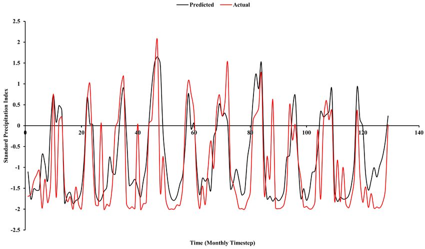
B. Datta et al.

                                 model by utilizing various hydrologic, meteorological, and geohydrology pa-
                                 rameters. This model will be evaluated for possible application to data obtained
                                 from the North Queensland region to mitigate critical impacts on water scarcity.
                                 Several models will be generated to assess how different parameters may be af-
                                 fecting drought severity of the study area. Upon the successful evaluation of the
                                 model capabilities and accuracy, performance of the models is evaluated and
                                 tested with past/present data to ensure accuracy.

                                 2. Methodology
                                 2.1. Drought Indicators
                                 Categorizing and assessing a drought is essential to determine when drought re-
                                 sponse actions need to be implemented. The use of drought indicators and trig-
                                 gers is important to assess the onset of drought conditions, monitor, and meas-
                                 ure drought events, and to decrease drought impacts [15]. Drought indicators,
                                 essentially, are variables that identify and assess drought conditions, which are
                                 commonly based on hydrological and meteorological variables. Examples of
                                 such commonly used indicators include precipitation, soil moisture, stream flow,
                                 groundwater levels, surface water reservoir levels, temperature, and evapotran-
                                 spiration. As an indicator breaches a certain threshold (often referred to as a
                                 trigger), this categorizes the drought and typically may depict levels of severity.
                                 The severity of droughts can be characterized by drought indexes that have been
                                 developed to detect, monitor, and assess drought events [5]. There are numerous
                                 indices used throughout the industry, which have played a major role in drought
                                 management where the most commonly used indices include PDSI, SPI, SMI,
                                 and ENSO. Brief description for each of these indices are provided in the fol-
                                 lowing paragraphs.
                                    The PDSI has been used for the past 50 years as a means of providing an indi-
                                 vidual measure of meteorological drought severity [16]. Three indicators are
                                 considered in the calculation of PDSI: Precipitation data, temperature data, and
                                 the available water content in the soil. From these indicators, variables such as
                                 soil recharge, evapotranspiration, runoff, and the moisture loss in the top soil
                                 layers can be found. The severity of the drought in question is considered to be a
                                 function of both magnitude and frequency of the moisture deficit [17]. However,
                                 there are a few limitations associated with the PDSI approach. These limitations
                                 include: an intrinsic time scale that makes it more suitable for agricultural ap-
                                 plications, and not so much for hydrologic applications, that runoff only occurs
                                 after all soil layers are saturated causing underestimation, and the reaction time
                                 to respond to forming and diminishing droughts [1].
                                    The SPI was developed to provide a better representation of the wetness and
                                 dryness in comparison to the PDSI approach. SPI was developed to quantify a
                                 precipitation deficit for different time scales [17]. It is basically, a standardizing
                                 transform of the probability of long-term precipitation that has been recorded
                                 [16]. This long-term record is then fitted to a probability distribution, which is
                                 transformed into a normal distribution so that the mean SPI for the location and

DOI: 10.4236/jwarp.2021.138033                        610                     Journal of Water Resource and Protection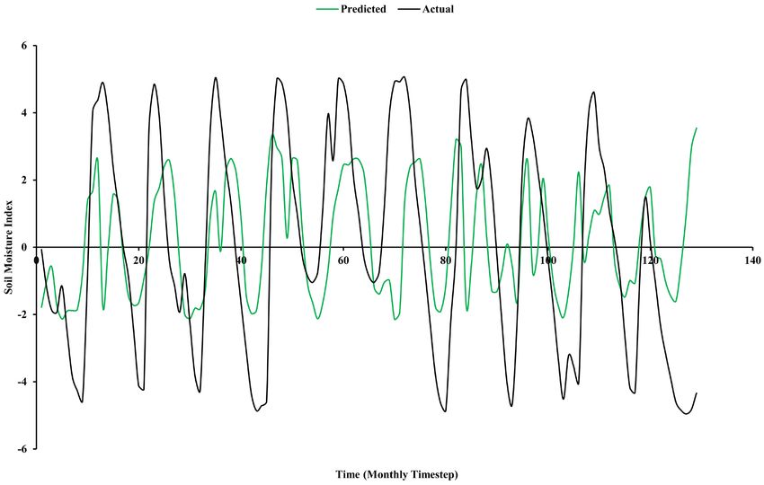
B. Datta et al.

                                 desired period is zero with a standard deviation of one [1]. Ideally, twenty to
                                 thirty years of monthly values (or more) would be optimal for accurate results.
                                 The time series of the SPI is then used for drought monitoring by setting specific
                                 thresholds of the SPI for defining the drought beginning and ending times. An
                                 accumulation of the SPI values can be used to assess the drought severity by us-
                                 ing the indicators specified in [17]. There are, however, limitations that the SPI
                                 encounter where the length of rainfall data used has a significant impact on the
                                 SPI values. Mishra and Singh [1] suggested that when calculating SPI values,
                                 computed over different lengths of time, it may result in significantly incon-
                                 sistent values. However, SPI is relatively simple to find given minimal inputs.
                                    Soil moisture is an important parameter when considering the hydrological
                                 balance and surface interactions. However, none of the previously mentioned
                                 indices directly considers soil moisture content as part of the index. Therefore,
                                 the development of SMI was developed by the High Plains Regional Climate
                                 Centre to assist in the onset of agricultural drought by indicating the observed
                                 moisture of the soil relative to a plants ability to extract water [18]. The values
                                 obtained through calculations procedures form a distribution where the θ values
                                 are scaled from -5 (severely deficient water content) to 5 (very wet). This index
                                 has been utilized in many different scenarios since its development for calculat-
                                 ing the water stress in Nebraska and has proven to be particularly useful [19]. El
                                 Niño and La Niña events occur naturally in the global climate system. The oc-
                                 currences of these events are due to the change in state of the Pacific Ocean and
                                 the atmosphere surrounding it from its normal state for a period of several sea-
                                 sons. The effect of El Niño events in the Australian region (Western Pacific) as-
                                 sociates with the cooling of the ocean, whereas La Niña events have the reverse
                                 effect. This however acts in reverse order when considering the central and east-
                                 ern pacific region where the theory of these events was first acknowledged. The
                                 changes that continuously occur in the Pacific Ocean and its surrounding at-
                                 mosphere occur in a cycle called the ENSO.
                                    All the previously mentioned indices, and majority of others that have been
                                 derived, use precipitation as a primary parameter for the prediction and assess-
                                 ment of drought [1]. The cause of torrential or lack of precipitation has been
                                 proven to be related to atmospheric phenomena, for instance ENSO, Sea Surface
                                 Temperature (SST), and Geopotential Height (GpH) [10]. However, the rela-
                                 tionship between the climate indices and precipitation is dependent on the re-
                                 gion to be forecasted. For example, the use of ENSO data will be reliable in the
                                 pacific region such as Eastern Australia and Peru but, will not be a reliable fore-
                                 casting tool for a region like Europe. In order to produce accurate drought-forecast
                                 models, the prediction of ENSO actions is important particularly in Australia.
                                 Three approaches are generally used in predicting ENSO:
                                    1) Statistical Models (Oceanic & Atmospheric Models): currently the most
                                 used model used. However, is limited due to the lack of time scale data as rec-
                                 ords only go back to the 1950’s.
                                   2) Physical Ocean & Statistical Atmosphere Models: this method is the second

DOI: 10.4236/jwarp.2021.138033                        611                    Journal of Water Resource and Protection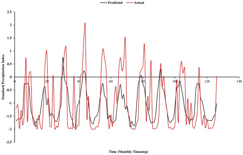
B. Datta et al.
most used method. The forecasting of ENSO relies on the physical laws that
govern the ocean’s response to variations in atmospheric boundary conditions.
3) Physical Coupled Ocean & Atmosphere Models
These three schemes have forecast lead times that are typically similar whereas
the simple models, 1 and 2, have an approximate accuracy for lead times to 1
year. Scenario 3 can predict slightly further in time, however, is a slightly more
complex method [20]. These models provide a strong forecasting analysis tool
(when used correctly) which has been utilized by many, particularly in Australia.
These indices are great tools for drought prediction. However, they require a
large scale of indicators to be able to predict rainfall data accurately.
2.2. Drought Forecasting
The forecasting of drought essentially requires past data (hydro-meteorological
variables), a set of drought and climatic indices, and a suitable prediction model
to predict the probability of occurrence as well as the nature of severity of
drought [10]. The input variables for drought prediction vary depending on dif-
ferent types of droughts to be forecasted. For instance, historical precipitation
data is needed to predict meteorological drought events. On the other hand,
prediction of hydrological drought scenario necessarily demands reservoir water
level, stream flow, and ground water levels data. Likewise, agricultural drought is
predicted by using data on soil moisture content and crop yield data.
Several drought indices, discussed earlier, have been derived to assess the ef-
fect of a drought and defining different drought parameters. In addition, the use
of climate indices such as ENSO is used in conjunction with the hydrological
values for long-term drought forecasting [10]. The prediction of drought can be
made by utilizing regression models, time series models, probability models,
neural network models, and hybrid models [10]. Current study utilizes the im-
plicit pattern recognition capability of a trained and tested ANN to develop a
drought prediction model.
2.3. The Study Area and Data
The data used in this study are obtained from two sources: Bureau of Meteorol-
ogy, Australia and the Townsville City Council, Queensland, Australia. The data
on soil moisture, precipitation, evapotranspiration, temperature, and the historic
Ross River dam (located in the study area) levels are collected from these two
sources. The SPI and SMI indices are calculated using the procedures mentioned
in the previous subsections of the methodology section. In addition, groundwa-
ter levels and groundwater salinity data are obtained from two bores within the
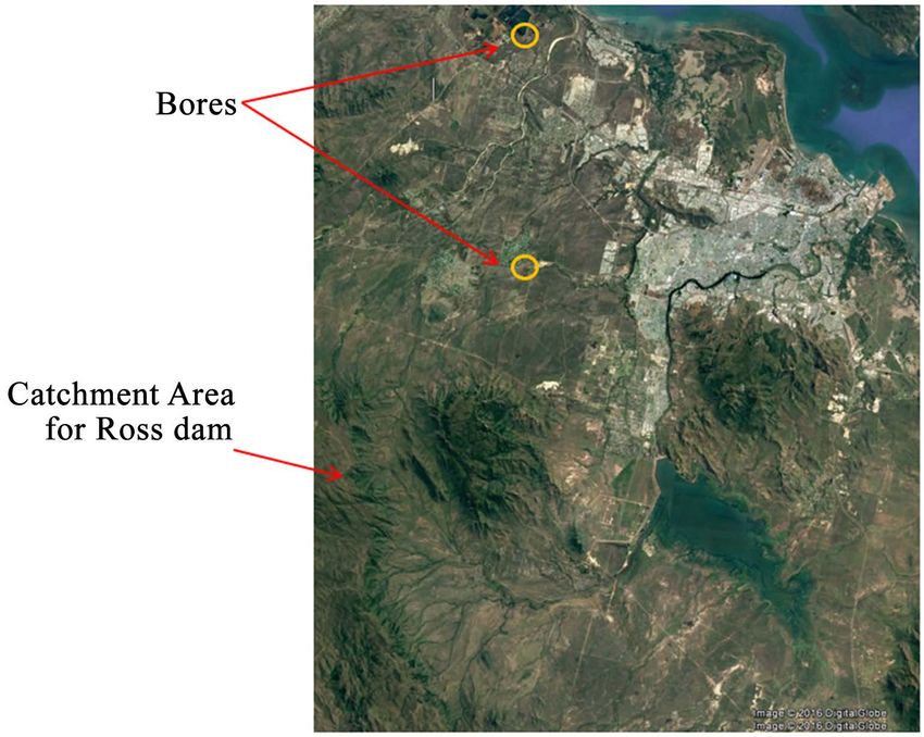
Townsville catchment as shown in Figure 1 below.
The implementation of the usable datasets varied depending on the number of
inputs and outputs to be specified, and whether the datasets are time dependent
or not. The data used was organized and manipulated that includes shifting data
to different prediction ranges e.g., for a 3-month prediction model, the target
data was shifted up three-time steps with respect to the input data.
DOI: 10.4236/jwarp.2021.138033 612 Journal of Water Resource and Protection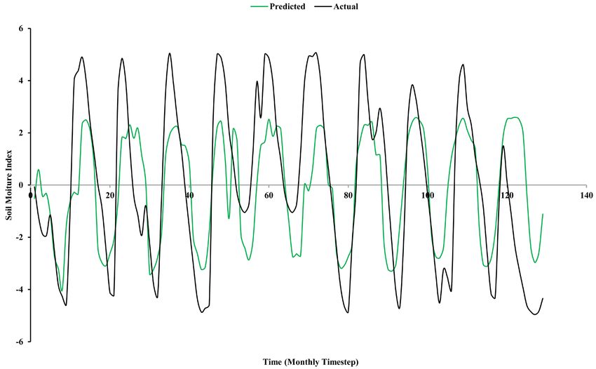
B. Datta et al.
Figure 1. Study area (Townsville catchment with bore locations).
2.4. Model Selection/Training
This study utilizes time series neural networks as a prediction tool for future
scenarios of drought forecasting. In particular, Non-Linear Autoregressive with
External Input (NARX) model was utilized as the preferred neural network tool.
This model uses both time series and regression analysis within its process to
maximize the computational ability and efficiency to achieve optimal output re-
sults.
The number of layers utilized throughout testing was maintained at 2 layers:
one hidden layer and one output layer with a consistent number of neurons (de-
fault of 10 used). Furthermore, a time delay of two-time steps was initiated to
ensure the system can learn and start accurately approximating a value by the
third time step in the training process as seen in Figure 2.
The NARX model takes the form of:
y ( t ) = f ( x ( t − 1) x ( t − d ) , y ( t − 1) y ( t − d ) ) (1)
where, d = number of delays, and t = time step.
The training performance is evaluated by computing the Mean Square Error
(MSE) as shown in Figure 3, and repeatedly training the data until sufficient
performance is identified.
When the inputs are not assumed to be time dependent, such as the salinity in
bores, a different ANN structure, Feed Forward Back propagation (FFB) was
used. This ANN structure does not feed the output data back as the next input
like the NARX, rather each input is independent of one another, and the rela-
tionship is purely between the input and output without respect to time. The
structure of the ANN model used for this purpose can be viewed in Figure 4.
The training procedure is similar to the NARX model and follows the same per-
formance steps.
After satisfactory training of the models, the trained and tested models are
used for future predictions. The predicted results were compared directly against
the actual values to validate the accuracy of the model and the simulation.
DOI: 10.4236/jwarp.2021.138033 613 Journal of Water Resource and Protection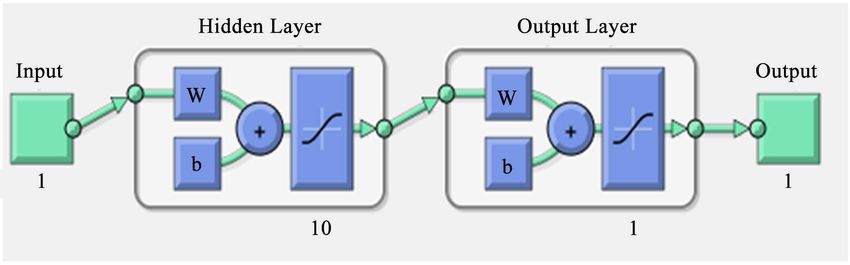
B. Datta et al.

                                     Figure 2. Algorithm/ANN Map dependent on time.

                                 Figure 3. MSE plot.

                                 Figure 4. Algorithm/ANN Map independent of time.

                                 Hundreds of these tests were conducted for several scenarios where inputs and
                                 outputs were changed, length of prediction was altered, and input simplicity.
                                 The tests that acquired reasonable results were sub divided into three drought
                                 scenarios. Simulation can then be conducted with additional input variables
                                 once validation of results showed sufficient accuracy. This can be done by using

DOI: 10.4236/jwarp.2021.138033                         614                  Journal of Water Resource and Protection
B. Datta et al.
just one-time step at a time if required. The model will then produce a predicted
output value for a specific lead-time for which the data was trained i.e., three
months.
3. Developed Models
A large number of ANN models were generated in the testing phase. However,
the final and informative tests have been collaborated and identified under each
drought type subgroup. Each model underwent the methodology previously
stated above.
3.1. Meteorological Drought
A large number of ANN models were generated in the testing phase. However,
the final and informative tests have been collated and identified under each
drought type subgroup. Each model underwent the methodology previously
stated above.
Prediction model 2 takes advantage of the SOI as well as the addition of
monthly precipitation values and monthly average maximum temperature
measurements. The purpose of this model is to include additional dynamic in-
puts to assist with a prolonged lead-time of 6 months.
Figure 5 represents the inputs and outputs to be used to generate a particular
prediction model to find SPI values at a lead-time of 3 and 6 months. The model
uses both agricultural and meteorological input parameters to assess the appro-
priate wetness intensity accurately. The purpose of interchanging the lead-time
is to assess the error variation with a prolonged lead-time.
3.2. Hydrological Drought
There are two types of hydrological models generated for hydrological drought:
Surface water levels, and ground water levels. The first model incorporates the
use of drought indices as inputs to predict the water levels of the Ross River
dam, as illustrated in Figure 6(a).
Figure 5. Developed models: (a) Model 1; (b) Model 2; (c) Models 3 and 4.
DOI: 10.4236/jwarp.2021.138033 615 Journal of Water Resource and ProtectionB. Datta et al.
Figure 6. Developed models: (a) Model 5; (b) Models 6, 7, 8, and 9.
Two bores in Townsville, north Queensland, Australia were assessed in this
next model, Bore 11800007A and Bore 11700027B. Firstly, the groundwater table
was predicted using a NARX model with a lead-time of 3 months. Once reason-
able results were obtained, a FFB model was used to link the predicted ground-
water levels with the salinity of the ground water. The schematic diagram of the
modelling approach is presented in Figure 6(b). The purpose of using two dif-
ferent bores is to assess the conditions of a coastal aquifer in the vicinity of the
coast, and also, relatively away from the coast. Then distinguish the different
effecst the inputs have on the prediction.
3.3. Agricultural Drought
To assess agricultural drought conditions, the use of the SMI at the root zone
soil is a good tool and indication of drought severity. Therefore, two prediction
models were generated with the use of different input variables. The first predic-
tion, as seen in Figure 7(a), utilized the meteorological parameter SPI as an in-
put. This parameter was used as there may be a delayed (3 Month) correlation
between the wetness intensity, and the soil moisture at the root zone layer. By
using a single variable, it makes the manipulation of data much simpler.
The final test utilizes the average monthly soil moisture and the total monthly
evapotranspiration occurring. These parameters were chosen as input as they
represent the movement of water in the soil itself. A maximum lead-time of 3
months was used, as this model does not account for any meteorological varia-
bles.
4. Results and Discussions
This section addresses the results obtained through testing, where the overall
performance of the models was validated. Through these tests, a functional and
simple ANN model was developed to predict meteorological, hydrological, and
agricultural drought for the Townsville region, in Northern Queensland, Aus-
tralia.
4.1. Meteorological Drought
For the assessment of meteorological drought, numerous tests were conducted
with variations in input parameters with respect to meteorological drought
DOI: 10.4236/jwarp.2021.138033 616 Journal of Water Resource and ProtectionB. Datta et al.
Figure 7. Developed models: (a) Model 10; (b) Model 11.
indices. With the available data, the obtained relationship between the inputs
and accurate precipitation measures was not realistic for an acceptable lead-time.
Therefore, present study used appropriate drought indices for the assessment of
drought conditions of the specified study area. Moreover, the use of a drought
index such as SPI drastically increased the ANN model ability to predict drought
conditions for an appropriate lead-time. Four tests were conducted to assess
meteorological drought prediction. The results of these tests are discussed here.
The first prediction model (Model 1) establishes the relationship between SOI
and SPI. As seen from the trend between actual and predicted values in Figure
8(a), three months lead-time prediction of SPI from SOI is quite accurate since
this model only assesses one variable, and the intensity of SPI is governed by
many meteorological factors. The simplicity behind the use of one variable
makes this prediction model a viable monthly model to grasp an understanding
of the approximate wetness in three months. The accuracy of this model, how-
ever, can be explained by the effect of ENSO on the east coast of Australia. Gen-
erally, the more intense this phenomenon is, the greater the intensity of wetness
in the region. As such, this model may be applied for prediction of drought sce-
narios on the Eastern coast of Australia by utilizing the limited available data.
Considering one variable is used for this prediction, the model has an approxi-
mate accuracy of 43 percent, which is quite reasonable for one input variable.
The second model (Model 2) utilizes average monthly high temperature (with
respect to daily maximum temperatures), monthly precipitation values, and SOI
as inputs to approximate SPI. This model incorporates two additional inputs on
top of prediction model1 to help gain a more accurate relationship over a longer
6-month ahead prediction. As seen in Figure 8(b), the predicted values follow
an accurate trend with respect to actual SPI values. However, the amplitude of
these prediction estimates is substantially lower, particularly when the SPI
reaches the wetter stages (>0). This may be because, dry periods are magnified
under certain temperatures; however, under wet conditions temperature may
not have a substantial effect. This is most likely because the temperature is taken
inland (Townsville) as opposed to out at sea, where increased heat enhances
evaporation and in turn, increases precipitation and wetness. Therefore, the use
of temperature and precipitation being used simultaneously may provide some
sort of cancellation effect when considering a wet period. Despite this, the model
prediction accuracy increases when considering intense drought scenario’s (SPI
< 0). An error analysis conducted on the dataset to assess the accuracy of the
DOI: 10.4236/jwarp.2021.138033 617 Journal of Water Resource and ProtectionB. Datta et al.
(a)
(b)
DOI: 10.4236/jwarp.2021.138033 618 Journal of Water Resource and ProtectionB. Datta et al.
(c)
(d)
Figure 8. Meteorological drought prediction; (a) Model 1; (b) Model 2; (c) Model3 (3-month lead time); (d) Model 4 (6-month
lead time).
DOI: 10.4236/jwarp.2021.138033 619 Journal of Water Resource and ProtectionB. Datta et al.
model indicates that the average percentage error occurring is 76.4%, therefore
which may seem quite low accuracy. It can be seen that the vast outliers will oc-
cur in the wetter periods in which the model does not quite meet the intensity of
the SPI, consequently affecting the model performance. As previously stated, this
model is more focused on the drought conditions and with that in mind, the er-
ror for drought condition assessment is substantially lower.
The third model (model 3) developed utilizes a wide range of input variables,
namely monthly precipitation, SOI, monthly evapotranspiration, and average
soil moisture. These parameters represent a greater refinement of the cause of
drought conditions. Due to the inclusion of these additional inputs, the model
provided better results than expected over the original three-month lead-time.
Therefore, an additional model with a lead-time extended to six months was also
implemented. As seen in Figure 8(c), there is a good trend matching between
inputs and outputs, with matching amplitude indicating that there exists strong
relationship between these datasets. Change in SOI generally enhances intensity
of precipitation values, where precipitation values are also majorly governed by
evapotranspiration, and hence the change in water content in the soil. With such
relationships between inputs, a closer and more accurate model has been created
that has more accurate prediction capabilities of future values. Error analysis in-
dicates a lower error occurring when comparing with the previous model. With
a percentage error of approximately 42 percent, this model can be labelled to be
58 percent accurate. The reduction in error in this model is generally due to the
accuracy in intensity, particularly in the wetter periods. By utilizing the time se-
ries tool and reducing the overall lead-time to 3 months, the time steps can adapt
with the changes in input variables more simply.
Furthermore, model providing six-month ahead prediction (model 4) as seen
in Figure 8(d) also demonstrates a good trend of prediction. However, the in-
tensity of the predicted SPI does not match perfectly with the actual values. This
may simply be due to the prolonged lead-time of 6 months, hence reducing the
effectiveness of the relationship between the input values. Moreover, it can be
identified that the values react more appropriately with each given time step
when comparing to model 2. Appropriate error calculations seem to provide
some justification behind the model’s improved ability with respect to model 2.
Given an average accuracy of 34.7 percent, this model is a relatively accurate
model especially considering the lead-time being 6 months.
4.2. Hydrological Drought
This section in particular concerns one of the more important issues surround-
ing urban developments and the agricultural industry. Five models have been
developed for this purpose (Models 5 - 9). The results obtained from these mod-
els are presented and discussed in the following sub-sections.
Model 5 (Surface Water: Ross River Dam Water Levels)
This prediction model incorporates the use of the two drought indices, SPI
and SMI, to help predict Ross dam water levels. The use of additional inputs was
DOI: 10.4236/jwarp.2021.138033 620 Journal of Water Resource and ProtectionB. Datta et al.
trialed prior to final validation of these inputs, however, did not improve neither
accuracy nor simplicity of the model and output values. As can be seen in Figure
9(a), accurate interpretations of dam level readings with a lead-time of 3 months
can effectively be found. The model generates an accurate trend that follows ac-
tual water levels which continues along time steps. However, in months of major
water influx, the predicted dam levels typically lag one-time step behind which is
expected whilst using drought indices as an input. This is not necessarily an
overly disastrous occurrence as the model adequately mimics negative change in
levels quite well. Therefore, the model is near perfect for drought mitigation and
management strategy development. However, it is worth mentioning that the
results do have fluctuations where predicted dataset tends to be slightly higher
than actual values with slight fluctuations. A possible explanation for this is the
exact location in which the inputs were taken. The data obtained is measured in
the Townsville CBD, which is a substantial distance from both the Ross River
dam and the catchment area itself. So, just because there was substantial rain in
the CBD hence increasing the SPI and SMI thresholds, does not mean that the
rainfall intensity and therefore drought indices will be identical within the dam’s
catchment. The resolution to this problem is to simply retrieve precipitation data
within the catchment zone, if available, which could potentially reduce the error
drastically and possibly increase the lead-time to something more respectable.
Furthermore, this model does not consider water usage from external sources
such as town water and the agricultural industry. Typically, with respect to pas-
tures, crops, and other vegetation, the use of water peaks during the drier peri-
ods. This is due to the reduction of rainfall and therefore creating increasing
demand of water to maintain vegetation life sufficiently. This may be another
reason as to the decrease in accuracy as the dam levels decrease. The error pre-
sented in this model is substantially lower than previous models generated. At an
accuracy of approximately 85 percent, it can be utilized as an efficient and effec-
tive tool to help manage water supply.
Model 6 (Ground Water: Groundwater Table) Bore: 11700027B
This model assesses the effect and correlation between SPI and groundwater
table on a coastal aquifer at bushland beach of Townsville, Queensland, Austral-
ia. The data in Figure 9(b) represents the depth measured from ground level to
the datum level of the water and plotted against the predicted data. The selection
of SPI without the inclusion of SMI was found to have the closest correlation.
The results in Figure 9(b) show a good correlation between input and output
values and show a clear response to changes in SPI values as seen for the first
10-time steps. Following this, the prediction overcompensates for several time
steps and assumes a larger amount ground water is present. A possible scenario
for this occurrence may be due to an increased ratio of volume with respect to
the aquifer height, which the model may not have had enough experience within
the training state. A solution to this would simply be to have the ability to access
a larger dataset for a coastal aquifer in the region, which is currently not availa-
ble. However, this model still proves to be accurate with minor error variations.
DOI: 10.4236/jwarp.2021.138033 621 Journal of Water Resource and ProtectionB. Datta et al.
(a)
(b)
DOI: 10.4236/jwarp.2021.138033 622 Journal of Water Resource and ProtectionB. Datta et al.
(c)
(d)
DOI: 10.4236/jwarp.2021.138033 623 Journal of Water Resource and ProtectionB. Datta et al.
(e)
Figure 9. Prediction of hydrological drought; (a) prediction model 5; (b) prediction model 6; (c) prediction model 7; (d) predic-
tion model 8; (e) prediction model 9.
The error occurring in this test verifies the simplicity of the relationship be-
tween groundwater levels and SPI values with an approximate accuracy of 97
percent. However, this model does not directly assess drought conditions, rather
merely relates ground water fluctuations with respect to drought conditions. A
greater assessment of water storage capability and depth capabilities would close
this limitation. However, the results from the test may then be also used to pre-
dict salinity levels in the coastal groundwater aquifer.
Model 7 (Salinity) Bore: 11700027B
The use of the predicted dataset from model 6 was utilized to assess the salin-
ity changes, and the effects of water levels on these values. It is expected that the
salinity levels will increase when ground water levels decrease. This becomes in-
creasingly obvious when comparing Figure 9(b) with Figure 9(c) as the salinity
levels tend to drop as ground water level decreases. This is due to saltwater in-
trusion from the interaction with the close proximity seawater. As the freshwater
head decreases, salt water tends to seep in and start to replenish the reduced wa-
ter level, which in turn, increases the salinity of the ground water. Therefore, to
assess this, a FFB ANN model was utilized to find the relationship between the
ground water level and the salinity content without needing to consider a time
step.
The results obtained from the FFB show relatively sound performance and an
accurate relationship. Despite the anomaly occurring at the 7th and 12th time
step, the trend between the two series is more or less accurate. By using this tool
DOI: 10.4236/jwarp.2021.138033 624 Journal of Water Resource and ProtectionB. Datta et al.
after predicting the ground water level, a quick assessment of the bore water
quality can be approximately assessed 3 months in advance to ensure the salinity
level does not exceed the (1000 uS/cm) mark. As can be seen in the graph, the
salinity for this water far surpasses the minimum salinity requirement. This bore
cannot be used effectively for watering purposes, however, was used to depict the
relationship between groundwater levels and salinity. The model, however, can
be increasingly accurate with the inclusion of more data points and therefore as-
sisting the training function. Despite this, a clear relationship can be gathered
with small amounts of data training. Average test error is 3.73 percent meaning
that the resulting model is around 96% accurate.
Model 8 (Ground Water: Groundwater Table) Bore: 11800007A
This prediction model assesses the groundwater table (depth to datum) of an
inland aquifer in the Ross River basin. The results given in Figure 9(d) provide
the representation of the bore depth with respect to a particular date. As previ-
ously discussed, many inputs were trialed however, the use of SPI proved to be
the simplest and utmost effective to minimize error. As can be seen in Figure
9(d), the predicted dataset follows a direct correlation to the actual ground water
levels. It is worth discussing the fact that this model had a substantially larger
input dataset in comparison to that for the coastal aquifer. This enhanced the
ability of the model to react accordingly with input deviations. It also allows the
user to trust the predicted value because of the trained dataset. Despite this, mi-
nor discrepancies can be seen occurring within the dataset commonly at major
points of flux.
The model gives an excellent 3-month ahead prediction with an accuracy of
95%. There are a couple of possible justifications behind the accuracy of this
model including the underground contribution of stream flow from the Ross.
This flow is highly dependent on precipitation and the seepage into the ground
water streams. It can then be identified that the use of SPI as an input is an ex-
ceptional parameter. Also being in a suburban area, the number of bores and
approximate water usage is relatively low when comparing to bores on agricul-
tural estates. The usage affect is therefore minimal which, is another possible ex-
planation for the accuracy of the prediction.
Model 9 (Salinity) Bore: 11800007A
By using the predicted data set obtained from the prediction model 8, a FFB
model was utilized to try to find a close relationship between salinity and ground-
water levels. However, when viewing Figure 9(e), there seems to be no direct
trend for the most part of the model. This model was carried out in the same
manner, as model 7 however was unable to find direct correlations between re-
sults. One possibility may be due to the low amount of data points required for
training. However, the previous model predicted well with a similar amount of
data. The most probabilistic cause is because this bore does not sit close to sea-
water. Therefore, the salinity does not depend on the depth of the bore, as there
is truly little or no salt water to intrution in this part of this aquifer. This howev-
er does not include contaminants and other intrusions on the aquifer, which
DOI: 10.4236/jwarp.2021.138033 625 Journal of Water Resource and ProtectionB. Datta et al.
may very well depend on the height on the bore. Furthermore, the salinity level
of this bore is sufficiently low and can be used for most of the vegetation.
4.3. Agricultural Drought
For the assessment of agricultural drought, two models were utilized which in-
cludes both meteorological and agricultural input datasets. To help reduce error
and simplify these models, a conversion of root-zone soil moisture to the drought
index SMI was conducted.
The first prediction model generated took advantage of the meteorological
index, SPI. The use of the SPI simplifies the models input requirements and
alerts the model of the wetter and drier periods. The results obtained from the
simulation (model 10), as seen in Figure 10(a), it does show that the SPI gives a
good indication on the wetter and drier periods. However, the amplitude of the
fluctuations in the predicted dataset is lower than that of the actual dataset. This
occurs particularly where the SMI is greater than 2.0 in the actual dataset. The
reasoning for this may well be that because, this dataset is of root-zone soil
moisture therefore when precipitation occurs, sufficient seepage is needed to be
able to reach this layer of soil. Since the seepage rate is slow, possible evapora-
tion may reduce the amount of water in the top soil moisture therefore reducing
the amount of moisture to seep to the root zone. However, in reverse effect of
this in the dry periods, the intensity can be mimicked. Because of this, the train-
ing program may have found that minimal error occurred when focusing on the
bottom end of data. The usual process to avoid this is to increase the number of
neurons in the program. However, since there was only one input, minimal ef-
fect occurred and correlation between the two values stayed the same. Despite
the intensity, there is a clear trend in the data, which can essentially show the
approximate fluctuations of the soil moisture. Furthermore, the model follows
an accurate time step arrangement where the peaks occurring in the predicted
dataset matches the time step of the actual data. Although accurate readings are
not absolute, the change in soil moisture can be assessed to some extent. With
that in mind, a 3-months prediction can allow the agricultural industry to pre-
pare and control soil conditions to the appropriate and desired growing capabil-
ities. Regardless of the percentage error being 78 percent as seen in Figure 10(a),
given the trend of this model, it does give a good indication on the soil moisture
trend.
The second prediction model in this category (model 11) was developed based
on the results obtained from the previous prediction model in the hope that the
use of evapotranspiration will help reduce the error focus from the lower regions
of the SMI. By observing Figure 10(b), there is a clear trend and accurate time
step formation between the simulated dataset and the actual dataset. However,
the simulation once again does not meet the intensity that occurs in the actual
data set. Although this occurs, the hypothesis mentioned in in the preceding
paragraph about the use of evapotranspiration to reduce the error focus on the
lower SMI values has been validated. It does however reduce the ability to
DOI: 10.4236/jwarp.2021.138033 626 Journal of Water Resource and ProtectionB. Datta et al.
(a)
(b)
Figure 10. Agricultural drought prediction; (a) prediction model 10; (b) prediction model 11.
DOI: 10.4236/jwarp.2021.138033 627 Journal of Water Resource and ProtectionB. Datta et al.
predict the scenarios because of the intensity change but does give a more even
distribution when concerning the trend. At the final time steps in the simulation
however, there appears to be the presence on an anomaly set of predictions. This
simulation anomaly may be due to uneven precipitation occurrence in those
months. The values for evapotranspiration were taken relatively close to the Ross
River dam whereas; precipitation values were taken at the airport some 15 km
inland. In these particular time steps, there was substantial rain occurring over
the coast of Townsville, which did not occur over the dam. This was an anoma-
lous rainfall occurrence and is the highly probable reasoning for these results.
Despite this, there appears to be a strong trend in the model and the generation
of the SMI can be achieved at a 3-month prediction efficiently.
5. Conclusions Limitations and Recommendations
Artificial Neural Network based prediction models can be utilized as an effective
prediction tool for the prediction of possible drought scenarios. The developed
models produced sound results that could essentially help the North Queensland
economy deal with the effect of drought with the assistance of future prediction
models. Based on the results of the present study, it can be concluded that ANN
based modelling is an effective, simple, and efficient prediction tool to accurately
forecast drought conditions. It is also demonstrated that meteorological drought
conditions can effectively be assessed using the SPI which can be approximately
forecasted for a lead time of up to 6 months in advance. Hydrological conditions
have the ability to be forecasted using drought indices such as SMI and SPI. Sur-
face water levels of the Ross River dam can be predicted at a lead-time of 3 months
without any considerable error. Ground water conditions including groundwater
levels and salinity intrusion for the specified bore locations of the coastal aquifer
can also be successfully modelled using the proposed ANN based models. On
coastal aquifers, salinity levels are highly dependent on ground water levels.
However, groundwater level has minimal effect on saltwater intrusion for inland
aquifers. SMI is an effective tool to assess agricultural drought conditions and
can be forecasted using both meteorological and agricultural values with a lead
time of 3 months. This can allow the agricultural industry to prepare and control
soil conditions to the appropriate and desired growing capabilities.
For accurate prediction of drought scenarios using any prediction model re-
quires a considerable amount of past data. Furthermore, the calculation of both
SPI and SMI should utilize 20 - 25 years’ worth of normalized data to ensure
greater variations and values of the index. However, only 11 years of historical
data were accessible for calculating the indices.
The management of the use of bores, particularly in gardens and lawns, heav-
ily relies on the conservation programs that are in place. A good example of a
conservation program is Townsville Water Program where the restriction of wa-
tering has set periods, i.e., between 6 pm and 8 pm twice a week, which moreo-
ver depends on the restriction level. If these water restrictions are not abided by,
DOI: 10.4236/jwarp.2021.138033 628 Journal of Water Resource and ProtectionB. Datta et al.
then fines may be dealt with. This however is not the most effective solution for
groundwater control and needs to revise as the depreciation of water in aquifers
often causes saltwater intrusion. Water quality in aquifers can be influenced by
the effect of saltwater intrusion as the water level of the aquifer falls. Appropriate
management of bores needs to be implemented to restrict this event from occur-
ring. Two common alternatives for controlling saltwater intrusions include a
planned pumping strategy, and planned extractions from barrier wells [21].
Salinity has been recognized as a problem around coastal regions of Australia
in aquifers. Salinity affects crop and vegetation growth when used for irrigation
purposes and in high enough doses, can reverse effect osmosis. Acceptable levels
of salinity are usually of salinity levels of 700 μS/cm or less. However, the effect it
has on individual crop yield depends on the crop itself. For example, fruit crops
can accept salinity of up to 1000 μS/cm without affecting crop yield and pastures
can accept up to 1300 μS/cm without affecting yield. All of these aspects will
need to be considered for developing short term groundwater management
strategies.
The main focus of this study was to construct and then verify the feasibility
and plausible accuracy of predicting various drought scenarios, including Mete-
orological, Hydrological, and Agricultural drought scenarios on a sub-regional
scale. A number of different prediction models are developed and the perfor-
mance of these models is evaluated, within the limits of available data, related to
the tropical application area of Townsville in Queensland, in Northern Australia.
The choice of the study area was based on the recent occurrence of a fairly long
drought (2014-2015 to early 2019) that had serious consequences in this study
area comprising of urban and agricultural land use. The prediction models de-
veloped and evaluated predict different likely consequences of drought scenarios
related to different aspects. The variations tested represent advantages and dis-
advantages, while affecting accuracy. Therefore, no particular model is selected
or recommended for universal use.
The aim was to analyse the feasibility of using the proposed approach for pre-
diction of different drought aspects. Further studies with robust data sets are
necessary for recommending a particular set of models with wide applicability.
Also, due to the fact that the application is limited to a region forming part of a
state, it was felt that the utility of incorporating larger scale models, e.g., Global
Circulation Models (GCMs) may not be very useful for this limited application
area, short-term prediction scenario. The lead times were however, short enough
to be useful as real time prediction models, with possible utilization for short
term or real time planning and operation of reservoir (e.g., Ross River dam), or,
for developing real-time groundwater management strategies to mitigate im-
pending drought consequences.
This study is a preliminary effort in developing drought prediction models for
the dry tropical region in the vicinity of Townsville. More rigorous development
and evaluation of prediction accuracy are no doubt necessary as the next step in
order to incorporate these prediction models for evolving sustainable, reliable
DOI: 10.4236/jwarp.2021.138033 629 Journal of Water Resource and ProtectionYou can also read