APPENDIX N - EXISTING ENVIRONMENT MAPS
←
→
Page content transcription
If your browser does not render page correctly, please read the page content below
APPENDIX N – EXISTING ENVIRONMENT MAPS
This appendix provides further planning environment details to support the summary in section 4 of the AEE, including
details about the zones, overlays, controls, precincts, designations and plan changes sourced from the AUP
GeoMaps (updated 20 May 2021).

Zones
The zones that apply to the Project are illustrated in Figure 1 below.
The Strategic Transport Corridor Zone provides for the development and use of state highways and rail corridors as
a single, integrated transport system operated by more than one agency. SH1 and SH22 are operated by Waka
Kotahi and the NIMT rail corridor is operated by KiwiRail.
The Business Light Industry Zone provides for industrial activities that do not generate objectionable odour, dust or
noise in sections of land either side of the SH1 corridor.
The Residential Mixed Housing Suburban Zone provides for residential activities that retain the suburban built
character in the surrounding land adjacent SH1 (north of Otūwairoa (Slippery Creek) Bridge). The Residential Mixed
Housing Urban, and Residential Terrace Housing and Apartment Buildings zones provide for high-intensity residential
activities on land to the west of Jesmond Bridge.
The Future Urban Zones are currently used for a range of rural activities and have identified sections of land either
side of the SH1 corridor (around Bremner Road Bridge and Quarry Road) as greenfield land suitable for urbanisation
in the future.
The Open Space Informal Recreation Zone provides for various informal outdoor recreational activities and access
to natural features in small parcels of land either side of the SH1 corridor. The Open Space Sport and Active
Recreation Zone the west of the Drury Interchange provides for indoor and outdoor organised sports, active
recreation and community activities. The Open Space Conservation Zone provides for limited development and
recreational activities along the coastline to the north of Jesmond Bridge in order to protect the values of the coastal
environment.
The Coastal General Coastal Marine Zone provides for the use and development in the CMA of Ngakoroa Stream
(northern side of Jesmond Bridge) whilst protecting the natural character and the ecological, cultural and landscape
values. Jesmond Bridge is located over water, which is not zoned, however the coastal zone provisions apply.

 WAKA KOTAHI NZ TRANSPORT AGENCY               FILE EXISTING ENVIRONMENT MAPS.DOCX | 11/06/2021 | REVISION A | PAGE 1
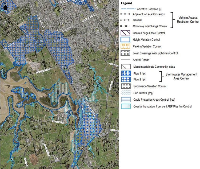
Figure 1 Zones

 WAKA KOTAHI NZ TRANSPORT AGENCY   FILE EXISTING ENVIRONMENT MAPS.DOCX | 11/06/2021 | REVISION A | PAGE 2
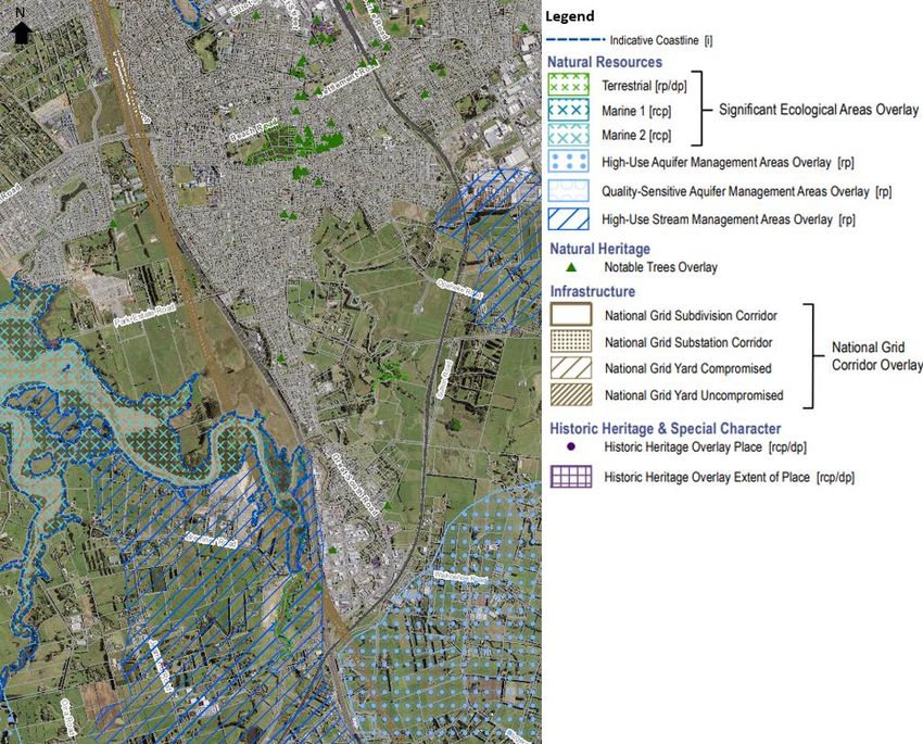
Overlays
The overlays that apply to various sections of the Project are illustrated in Figure 2 below.

Figure 2 Overlays

 WAKA KOTAHI NZ TRANSPORT AGENCY               FILE EXISTING ENVIRONMENT MAPS.DOCX | 11/06/2021 | REVISION A | PAGE 3

Controls
The controls that apply to various sections of the Project are illustrated in Figure 3 below.

Figure 3 Controls

 WAKA KOTAHI NZ TRANSPORT AGENCY               FILE EXISTING ENVIRONMENT MAPS.DOCX | 11/06/2021 | REVISION A | PAGE 4

Precincts
The precincts within the Project is illustrated in Figure 4 below. The Karaka 1 precinct provides for the continued use
and development of the New Zealand Bloodstock Karaka Sales Centre, enabling activities in relation to the sale and
auction of horses and stock over a series of annual sales.
The Hingaia 1 precinct is a Special Housing Area which provides for high density, integrated residential development
on the Hingaia Peninsula, with the aim to increase the supply of housing, to facilitate the efficient use of land, and to
co-ordinate the provision of infrastructure. The purpose of Hingaia 1 sub-precinct B is to ensure the development
contains affordable dwellings. The purpose of Hingaia 1 sub-precinct is to ensure the development contains dwellings
owned and operated by community housing providers, such as Kainga Ora.
The Drury 1 precinct is a Special Housing Area which provides for high density, integrated residential development
which is co-ordinated with the delivery of infrastructure required to service the precinct. The purpose of the precinct
is to ensure the development contains affordable dwellings.

Figure 4 Precincts

 WAKA KOTAHI NZ TRANSPORT AGENCY                FILE EXISTING ENVIRONMENT MAPS.DOCX | 11/06/2021 | REVISION A | PAGE 5

Designations
The designations within the Project are illustrated in Figure 5 below.

Figure 5 Designations

 WAKA KOTAHI NZ TRANSPORT AGENCY               FILE EXISTING ENVIRONMENT MAPS.DOCX | 11/06/2021 | REVISION A | PAGE 6
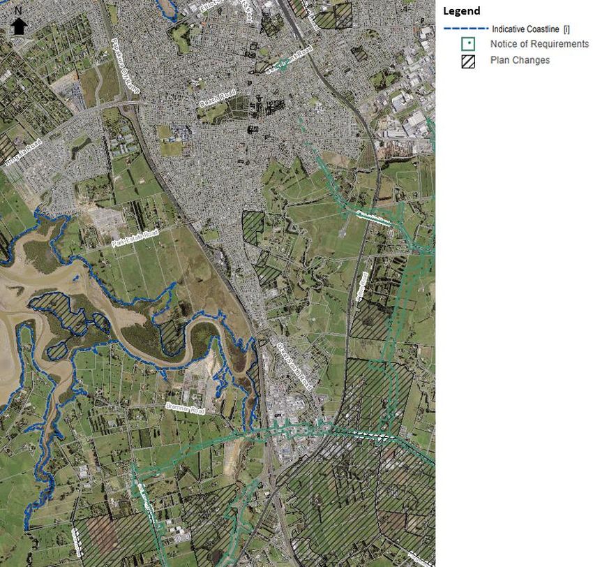
Plan Changes
The plan changes within and adjacent to the Project corridor are illustrated in Figure 6 below.

Figure 6 Plan changes

 WAKA KOTAHI NZ TRANSPORT AGENCY              FILE EXISTING ENVIRONMENT MAPS.DOCX | 11/06/2021 | REVISION A | PAGE 7
You can also read